earthquake ground damage hazard studies … · earthquake ground damage hazard studies and their...
TRANSCRIPT

1588
1 Opus International Consultants Limited, P O Box 12-003, Wellington, New Zealand. E-mail [email protected]
EARTHQUAKE GROUND DAMAGE HAZARD STUDIES AND THEIR USE INRISK MANAGEMENT, IN THE WELLINGTON REGION, NEW ZEALAND
Pathmanathan BRABHAHARAN1
SUMMARY
Earthquake ground damage hazards pose a significant risk to infrastructure, lifelines, buildings andlife in urban areas. Lifelines such as transportation, energy, water, wastewater andcommunications networks are important for the survival of the community in the aftermath ofearthquakes. Hazard identification, awareness, vulnerability and risk assessment, mitigation andpreparedness are important to be able to reduce the risk from earthquakes.
The paper illustrates the assessment of ground damage hazards such as liquefaction and slopefailure, and mapping with the aid of geographical information systems, through studies carried outin the Wellington Region of New Zealand. The methods developed and used for the grounddamage hazard studies are outlined. The hazard maps have been used to consider the effects ofearthquakes on lifelines, commercial and residential development and infrastructure, and theassociated risk.
The use of the hazard maps in developing processes and criteria aimed at reducing the risk todevelopment is outlined through appropriate examples. Assessment of the risk to lifelines such aswater supply, telecommunication and road networks helps manage the risk, through prioritisationand mitigation or planning for emergency preparedness. Risk-economic assessments can be avaluable tool in this process.
INTRODUCTION
New Zealand lies along the Pacific Rim and has a high level of earthquake hazard. New Zealand’s capital,Wellington, has a high risk from earthquakes due to a combination of high seismicity, unfavourable terrain andconcentrated development. Over the past decade, there has been significant effort in New Zealand to study andquantify the impact of earthquakes on the community, infrastructure and lifelines. Given the high risks, much ofthis work was initiated in Wellington.
In New Zealand, the Resource Management Act 1991 places a responsibility on local authorities for “the controlof any actual or potential effects of the use, development or protection of land, including for the purpose of theavoidance or mitigation of natural hazards …”. The Act has encouraged local authorities to take a more activerole in helping the community to become prepared for natural hazards such as earthquakes. Local authorities aredeveloping strategies to deal with natural hazards. The Wellington Regional Council has been the first in NewZealand to recognise the importance of earthquake hazard mitigation, and has an objective that “Any adverseeffects of natural hazards on the environment of the Wellington Region are reduced to an acceptable level”(Wellington Regional Council, 1995). This will need to be a long term and ongoing objective given the highearthquake hazards in the Wellington Region.
A number of studies to assess the earthquake hazards were commissioned by the Council to identify and presentthe hazards in the region, and included earthquake ground damage hazard studies and risk studies which are
15882
outlined in this paper. These have been complemented by studies by the Wellington Earthquake LifelinesGroup, which has considered the risk to lifelines on a very broad scale, and helped increase the awareness of the
risk from earthquakes. A number of follow-on studies have been initiated by territorial and lifeline authorities toassess the risk to specific infrastructure and lifelines. Some of these studies have included prioritisation andconsideration of mitigation measures to help with risk management.
HAZARD IDENTIFICATION STUDIES
Earthquake Hazards
Earthquakes are commonly associated with some or all of the following hazards leading to an impact on thepeople, built and natural environments :
• Fault rupture• Ground shaking• Ground liquefaction• Slope failure• Tsunami and seiche
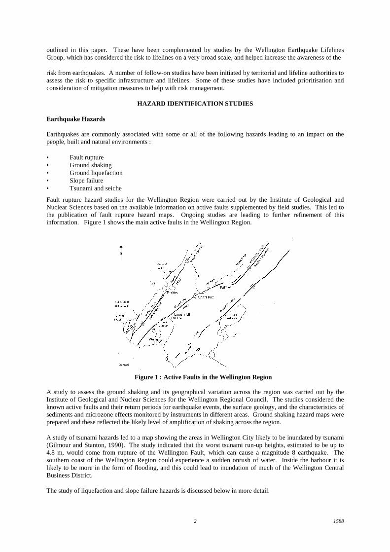
Fault rupture hazard studies for the Wellington Region were carried out by the Institute of Geological andNuclear Sciences based on the available information on active faults supplemented by field studies. This led tothe publication of fault rupture hazard maps. Ongoing studies are leading to further refinement of thisinformation. Figure 1 shows the main active faults in the Wellington Region.
A study to assess the ground shaking and its geographical variation across the region was carried out by theInstitute of Geological and Nuclear Sciences for the Wellington Regional Council. The studies considered theknown active faults and their return periods for earthquake events, the surface geology, and the characteristics ofsediments and microzone effects monitored by instruments in different areas. Ground shaking hazard maps wereprepared and these reflected the likely level of amplification of shaking across the region.
A study of tsunami hazards led to a map showing the areas in Wellington City likely to be inundated by tsunami(Gilmour and Stanton, 1990). The study indicated that the worst tsunami run-up heights, estimated to be up to4.8 m, would come from rupture of the Wellington Fault, which can cause a magnitude 8 earthquake. Thesouthern coast of the Wellington Region could experience a sudden onrush of water. Inside the harbour it islikely to be more in the form of flooding, and this could lead to inundation of much of the Wellington CentralBusiness District.
The study of liquefaction and slope failure hazards is discussed below in more detail.
Figure 1 : Active Faults in the Wellington Region
15883
Liquefaction Hazards
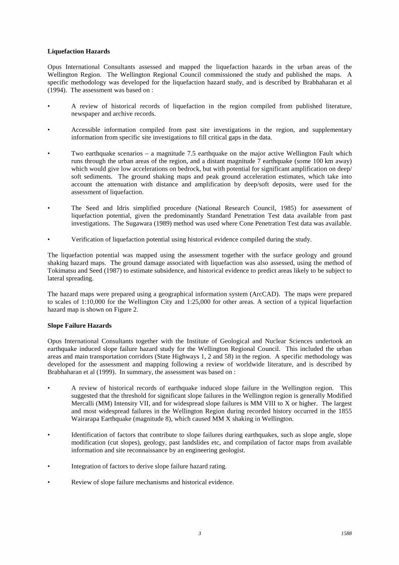
Opus International Consultants assessed and mapped the liquefaction hazards in the urban areas of theWellington Region. The Wellington Regional Council commissioned the study and published the maps. Aspecific methodology was developed for the liquefaction hazard study, and is described by Brabhaharan et al(1994). The assessment was based on :
• A review of historical records of liquefaction in the region compiled from published literature,newspaper and archive records.
• Accessible information compiled from past site investigations in the region, and supplementaryinformation from specific site investigations to fill critical gaps in the data.
• Two earthquake scenarios – a magnitude 7.5 earthquake on the major active Wellington Fault whichruns through the urban areas of the region, and a distant magnitude 7 earthquake (some 100 km away)which would give low accelerations on bedrock, but with potential for significant amplification on deep/soft sediments. The ground shaking maps and peak ground acceleration estimates, which take intoaccount the attenuation with distance and amplification by deep/soft deposits, were used for theassessment of liquefaction.
• The Seed and Idris simplified procedure (National Research Council, 1985) for assessment ofliquefaction potential, given the predominantly Standard Penetration Test data available from pastinvestigations. The Sugawara (1989) method was used where Cone Penetration Test data was available.
• Verification of liquefaction potential using historical evidence compiled during the study.
The liquefaction potential was mapped using the assessment together with the surface geology and groundshaking hazard maps. The ground damage associated with liquefaction was also assessed, using the method ofTokimatsu and Seed (1987) to estimate subsidence, and historical evidence to predict areas likely to be subject tolateral spreading.
The hazard maps were prepared using a geographical information system (ArcCAD). The maps were preparedto scales of 1:10,000 for the Wellington City and 1:25,000 for other areas. A section of a typical liquefactionhazard map is shown on Figure 2.
Slope Failure Hazards
Opus International Consultants together with the Institute of Geological and Nuclear Sciences undertook anearthquake induced slope failure hazard study for the Wellington Regional Council. This included the urbanareas and main transportation corridors (State Highways 1, 2 and 58) in the region. A specific methodology wasdeveloped for the assessment and mapping following a review of worldwide literature, and is described byBrabhaharan et al (1999). In summary, the assessment was based on :
• A review of historical records of earthquake induced slope failure in the Wellington region. Thissuggested that the threshold for significant slope failures in the Wellington region is generally ModifiedMercalli (MM) Intensity VII, and for widespread slope failures is MM VIII to X or higher. The largestand most widespread failures in the Wellington Region during recorded history occurred in the 1855Wairarapa Earthquake (magnitude 8), which caused MM X shaking in Wellington.
• Identification of factors that contribute to slope failures during earthquakes, such as slope angle, slopemodification (cut slopes), geology, past landslides etc, and compilation of factor maps from availableinformation and site reconnaissance by an engineering geologist.
• Integration of factors to derive slope failure hazard rating.
• Review of slope failure mechanisms and historical evidence.

15884
N
EW
S
WELLINGTON
Lambton Harbour
Evans Bay
Worser Bay
Liquefaction PotentialHighModerateVariableLowNo Liquefaction
Figure 2 : Typical Liquefaction Hazard Map
• Assignment of factor values and weightings and integration to obtain a slope failure susceptibility rating
Rs = Σ ( Fi . Wi ) (Equation 1)
where Fi represents factor values for the factor ‘i’ and Wi represents associated weightings, for factors– slope angle, slope modification, slope height, geology, past landslides and groundwater.
• Three earthquake scenarios – a magnitude 7.5 earthquake on the active Wellington Fault, a magnitude 7distant earthquake event (some 100 km away) and an Intermediate Scenario, an earthquake causing MMVII to VIII shaking in the Wellington Region.
• Mapping of slope failure susceptibility using the factor maps and the slope failure susceptibility ratingderived by combination of the factors.
• Presentation of slope failure potential for the three earthquake scenarios considered. The slope failuremaps were calibrated using the historical evidence of slope failures during earthquakes.
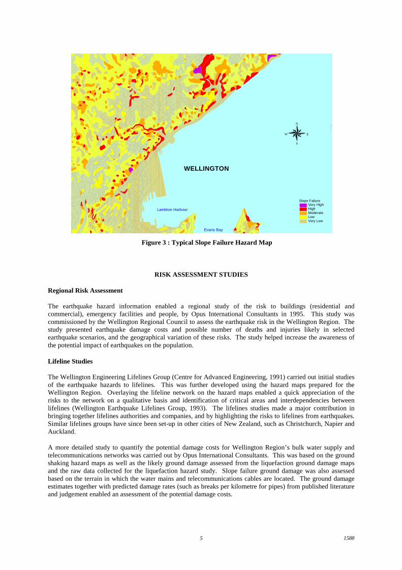
Slope failure hazard maps were prepared to a scale of 1:25,000, and have been published by the WellingtonRegional Council. A typical section of the slope failure hazard map is presented in Figure 3.
Hazard Maps
The liquefaction and slope failure hazard maps were prepared using ArcCAD, which is compatible with theArcInfo geographical information system.
The hazard information is held in Wellington Regional Council’s ArcInfo GIS system, and is available forearthquake risk studies and risk management by other territorial authorities. The information in GIS formatenables it to be readily used with GIS information on infrastructural assets and lifelines, to assess the risk tothese assets.
The hazard maps have also been published and are useful for engineering as well as information and educationalpurposes, to improve the awareness of the community to earthquake hazards.
15885
N
EW
S
WELLINGTON
Lambton Harbour
Evans Bay
Slope FailureVery HighHighModerateLowVery Low
Figure 3 : Typical Slope Failure Hazard Map
RISK ASSESSMENT STUDIES
Regional Risk Assessment
The earthquake hazard information enabled a regional study of the risk to buildings (residential andcommercial), emergency facilities and people, by Opus International Consultants in 1995. This study wascommissioned by the Wellington Regional Council to assess the earthquake risk in the Wellington Region. Thestudy presented earthquake damage costs and possible number of deaths and injuries likely in selectedearthquake scenarios, and the geographical variation of these risks. The study helped increase the awareness ofthe potential impact of earthquakes on the population.
Lifeline Studies
The Wellington Engineering Lifelines Group (Centre for Advanced Engineering, 1991) carried out initial studiesof the earthquake hazards to lifelines. This was further developed using the hazard maps prepared for theWellington Region. Overlaying the lifeline network on the hazard maps enabled a quick appreciation of therisks to the network on a qualitative basis and identification of critical areas and interdependencies betweenlifelines (Wellington Earthquake Lifelines Group, 1993). The lifelines studies made a major contribution inbringing together lifelines authorities and companies, and by highlighting the risks to lifelines from earthquakes.Similar lifelines groups have since been set-up in other cities of New Zealand, such as Christchurch, Napier andAuckland.
A more detailed study to quantify the potential damage costs for Wellington Region’s bulk water supply andtelecommunications networks was carried out by Opus International Consultants. This was based on the groundshaking hazard maps as well as the likely ground damage assessed from the liquefaction ground damage mapsand the raw data collected for the liquefaction hazard study. Slope failure ground damage was also assessedbased on the terrain in which the water mains and telecommunications cables are located. The ground damageestimates together with predicted damage rates (such as breaks per kilometre for pipes) from published literatureand judgement enabled an assessment of the potential damage costs.

15886
Infrastructural Risk Studies
A number of territorial authorities have commissioned studies to assess their exposure to earthquake hazards.One of the earliest comprehensive studies was carried out for the Porirua City Council by Opus InternationalConsultants. GIS data from the hazard studies, and infrastructural asset information for buildings, roads, watersupply and drainage were used to assess the earthquake risk during four earthquake scenarios.
Similar studies have just been completed for Upper Hutt City Council by Opus International Consultants. TheUpper Hutt integrated earthquake risk study has been carried out using a geographical information system(ArcCAD) by developing GIS models which derive the damage costs for each of the identified infrastructurelayers, for a given input earthquake MM Intensity. The models use parameters linked to the earthquake hazardmaps prepared for the Wellington Regional Council, and is flexible to accommodate refined data on theinfrastructure as it becomes available, new infrastructural assets that may be added to the network, or refinementof the hazard information. This provides a valuable tool for ongoing management of the risks to Council’sassets. The assets included roads, bridges, water supply, drainage, pump stations, reservoirs and buildings.
EARTHQUAKE RISK MANAGEMENT
Risk Management Options
The ultimate objective of earthquake hazard and risk studies is to manage the risks posed by earthquakes to thepeople and the built and natural environments. The risks from earthquakes cannot be eliminated completely inany society. The cost of risk reduction can be considerable and complete elimination may not be practical,affordable or economically viable. Therefore there is a strong need for risk management.
Brabhaharan (1998) presented possible earthquake risk management options. The risk can be managed by :
• Mitigation• Avoidance or Redundancy• Acceptance and Preparedness
Often a combination of measures may be appropriate. Risk can be defined as :
Risk = Hazard Likelihood x Consequences (Equation 2)
The likelihood of the earthquake, at any location cannot be changed. Avoidance considers means of relocatingto an area with a lower hazard. Much of earthquake risk management involves ways of managing theconsequences of the hazard to our asset or community of interest.
A number of initiatives have been taken in the Wellington Region, to manage the risk associated withearthquakes. The risk management initiatives are illustrated using selected examples.
Porirua City Council Planning Criteria
Porirua City Council have initiated risk management initiatives to reduce the risk to the community in the longterm, based a studies of potential risk management options prepared by Opus International Consultants. The riskmanagement initiatives were implemented through planning measures, discussed below.
Seismic Hazard Zones
Seismic Hazard Zones were derived from the individual earthquake hazard maps to show areas which hadearthquake hazards that required specific consideration during development, beyond design to normal buildingcode requirements. These zones included areas of significant amplified ground shaking, liquefaction, slopefailure and fault rupture. The zones were then related to the property boundaries from cadastral maps andinstalled in Porirua City Council’s geographical information system, and became part of the District Plan. Thisenables council officers to query individual properties and where located within the seismic hazard(consideration) zone, to provide information to developers as part of Land Information Memoranda (LIM) orProject Information Memoranda (PIM).
15887
Criteria for Control of Development
The District Plan also includes specially developed criteria for development in areas with significant hazardsbeyond that covered by building codes and depending on the nature of the development. For example, facilitiesthat will attract significant number of people will need to meet special requirements given the higher risk.
Upper Hutt Rural Road Risk Management
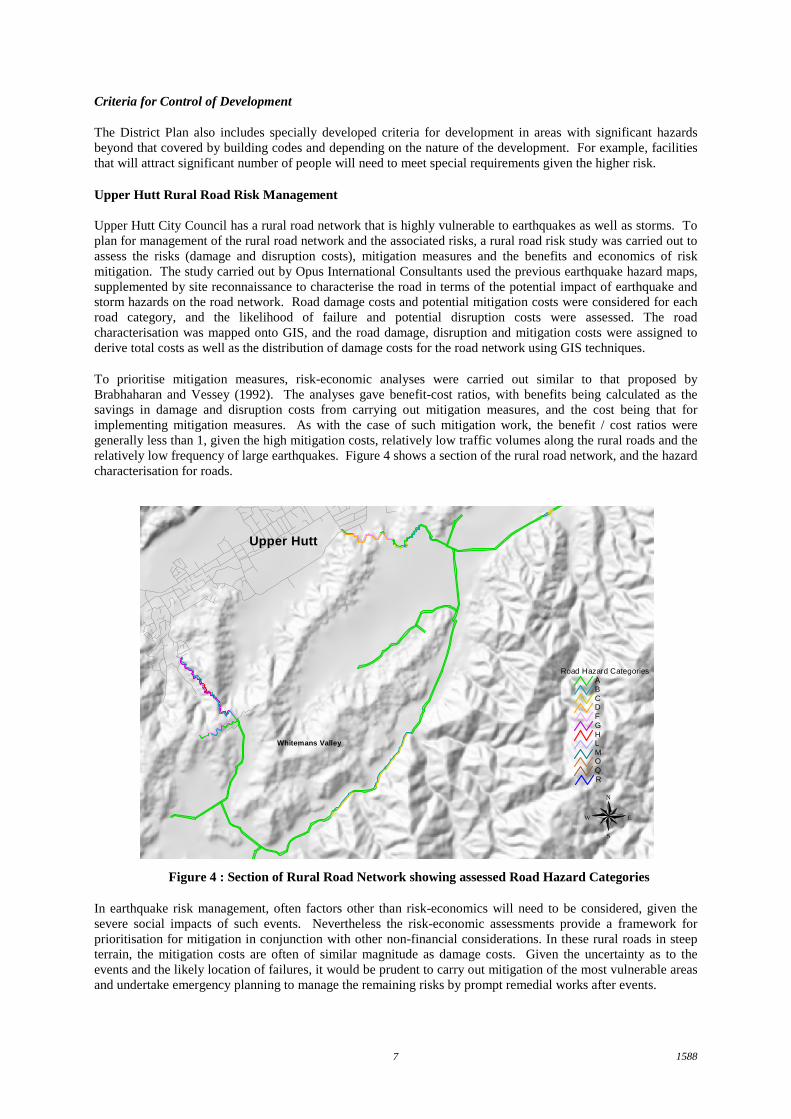
Upper Hutt City Council has a rural road network that is highly vulnerable to earthquakes as well as storms. Toplan for management of the rural road network and the associated risks, a rural road risk study was carried out toassess the risks (damage and disruption costs), mitigation measures and the benefits and economics of riskmitigation. The study carried out by Opus International Consultants used the previous earthquake hazard maps,supplemented by site reconnaissance to characterise the road in terms of the potential impact of earthquake andstorm hazards on the road network. Road damage costs and potential mitigation costs were considered for eachroad category, and the likelihood of failure and potential disruption costs were assessed. The roadcharacterisation was mapped onto GIS, and the road damage, disruption and mitigation costs were assigned toderive total costs as well as the distribution of damage costs for the road network using GIS techniques.
To prioritise mitigation measures, risk-economic analyses were carried out similar to that proposed byBrabhaharan and Vessey (1992). The analyses gave benefit-cost ratios, with benefits being calculated as thesavings in damage and disruption costs from carrying out mitigation measures, and the cost being that forimplementing mitigation measures. As with the case of such mitigation work, the benefit / cost ratios weregenerally less than 1, given the high mitigation costs, relatively low traffic volumes along the rural roads and therelatively low frequency of large earthquakes. Figure 4 shows a section of the rural road network, and the hazardcharacterisation for roads.
N
EW
S
Upper Hutt
Whitemans Valley
Road Hazard CategoriesABCDFGHL
OQR
M
Figure 4 : Section of Rural Road Network showing assessed Road Hazard Categories
In earthquake risk management, often factors other than risk-economics will need to be considered, given thesevere social impacts of such events. Nevertheless the risk-economic assessments provide a framework forprioritisation for mitigation in conjunction with other non-financial considerations. In these rural roads in steepterrain, the mitigation costs are often of similar magnitude as damage costs. Given the uncertainty as to theevents and the likely location of failures, it would be prudent to carry out mitigation of the most vulnerable areasand undertake emergency planning to manage the remaining risks by prompt remedial works after events.

15888
CONCLUSIONS
The Wellington Region of New Zealand has a high risk from earthquakes. The Wellington Regional Council hasa proactive strategy to reduce the adverse effects of natural hazards to an acceptable level, and a comprehensiveprogramme of earthquake assessment and mapping studies have been undertaken over the past decade.
Assessment and hazard mapping techniques have been developed for earthquake induced ground damagehazards – liquefaction and slope failure, and have been applied to the hazard mapping in the Wellington Region.The studies have been based on a technical assessment as well as verification using historical records. Thesehave the potential to be used in hazard mapping for other areas.
The hazard identification studies have allowed the assessment of earthquake risks for a range of infrastructuralassets and lifelines. These have allowed the risks to be quantified and used for risk management purposes. Thishas also been used extensively for insurance loss estimates. Planning measures can be used to encourageconsideration of earthquake hazards and risk management for new development. Porirua City Council has takensuch an approach.
Risk mitigation can often have a high cost. Risk-economic assessments can be useful to consider the economicbenefits from mitigation. This together with non-financial factors can be used to prioritise mitigation and makedecisions on appropriate risk management strategies.
ACKNOWLEDGEMENTS
I wish to acknowledge the initiatives of the Wellington Regional Council and the Upper Hutt City Council fortheir initiatives for managing earthquake risks in the region. I am also grateful to them for permission to publishinformation from their studies and to Opus International Consultants and colleagues for their support.
REFERENCES
Brabhaharan, P and Vessey, JV (1992). Development of Economical Solutions to Mitigate Geotechnical Risks :Waipaoa Water Treatment Augmentation Plant. 6th Australia-New Zealand Conference on Geomechanics.Christchurch. February 1992.
Brabhaharan, P, Hastie, WJ and Kingsbury, PA (1994). Liquefaction Hazard Mapping Techniques Developedfor the Wellington Region, New Zealand. Annual NZNSEE Conference, Wairakei, 18-20 March 1994.
Brabhaharan, P (1998). Hazard Assessment and Risk Management for Earthquake Disaster Survival. InvitedKeynote Address. Engineering in Natural Disasters – Survival, Relief and Restoration. Conference ’98. 25-27September 1998. Rabaul, Papua New Guinea. Institution of Engineers, PNG.
Brabhaharan, P, et al (1999). Earthquake slope failure hazards in the Wellington Region. Under preparation.
Centre for Advanced Engineering (1991). Lifelines in Earthquakes – Wellington Case Study. August 1991.
Gilmour, A and Stanton, B (1990). Tsunami Hazard in the Wellington Region. Regional Natural DisasterReduction Plan. Wellington Regional Council. June 1990.
National Research Council (1985). Liquefaction of Soils during Earthquakes. National Academy Press.
Tokimatsu, K and Seed, HB (1987). Evaluation of Settlements in Sands due to earthquake shaking. Journal ofgeotechnical engineering. ASCE Vol 113, No 8, pp 861-878.
Wellington Earthquake Lifelines Group (1993). 1993 Report. Wellington Regional Council. November 1993.
Wellington Regional Council (1995a). Earthquake and Geological Hazard Mitigation Strategy, WellingtonRegional Council. December 1995.