earthquake damage assessment using objective image ... · earthquake-induced damage...
TRANSCRIPT
Earthquake Damage Assessment Using Objective Image Segmentation: A Case Study of 2010 Haiti Earthquake
Thomas Oommen1, Umaa Rebbapragada2, and Daniel Cerminaro3
1Department of Geological Engineering, Michigan Technological University, Houghton, MI 49931; PH (906) 487-2045; FAX (906) 487-3371; email: [email protected] 2Jet Propulsion Laboratory, California Institute of Technology, 4800 Oak Grove Dr., Pasadena, CA 91109; PH (818) 354-0038; email: [email protected] 3Department of Civil and Environmental Engineering, Michigan Technological University, Houghton, MI 49931; email: [email protected] ABSTRACT
The free and open availability of high-resolution satellite and airborne imagery after the 2010 Haiti earthquake provided a new opportunity to analyze earthquake-induced damage. Previous work has analyzed pre- and post-event remote sensing images using pixel-based change detection. The drawback of these methods is that they have difficulty differentiating earthquake-induced damage from other natural and manmade changes. An alternate method is to analyze damage in terms of objects rather than image pixels. The significant advantage of object-based analysis is its ability to effectively use the characteristics of the change such as shape, length/width ratio, asymmetry etc. to differentiate between damage types. However, to make effective use of object-based analysis for earthquake-induced damage evaluation, we need a comprehensive understanding of all potentially useful earthquake-induced damage characteristics, specifically from a segmentation-based perspective.
In this study, we perform a case study on imagery from the Haiti earthquake that evaluates a novel object-based approach for characterizing earthquake induced surface effects of liquefaction against a traditional pixel based change technique. Our technique, which combines object-oriented change detection with discriminant/categorical functions, shows the power of distinguishing earthquake-induced surface effects from changes in buildings using the object properties concavity, convexity, orthogonality and rectangularity. Our results suggest that object-based analysis holds promise in automatically extracting earthquake-induced damages from high-resolution aerial/satellite imagery. INTRODUCTION Earthquakes are a major natural disaster associated with large scale destruction and high mortality rates. The Federal Emergency Management Agency (FEMA) estimates that a major earthquake in a highly populated area of the United States may cause up to $200 billion in losses. In developing countries, earthquakes not only cause human, property, and economic losses, but also results in the disruption of economic and social progress. A recent example of the havoc caused by an earthquake is the January 12th, 2010 Haiti Earthquake. This event leveled approximately 20 percent of the buildings in greater Port-au-prince; killed close to a quarter of a million people;

and left over a million individuals homeless in less than a minute (Eguchi et al. 2010). To date, prevention or prediction of earthquakes is only rarely achieved. However, the impact of earthquakes can be greatly reduced with effective disaster management (Montoya 2002).
Disaster management can be categorized in four phases: mitigation, preparedness, response, and recovery. Within the disaster management cycle, possibly the most critical and challenging phase is the response phase since the situation after the event is uncertain (Steinle et al. 2001). The overall cost of a disaster after the event, both in terms of economic damage and fatalities, is minimized when the response phase is quickly and efficiently managed (Kerle & Oppenheimer 2002). Effective management of the response phase requires accurate and timely damage assessment.
Damage assessment is performed through field survey and the analysis of remotely sensed data. Damage assessment through field survey has high accuracy; however, field survey requires extensive time and man power, especially if the area affected by the earthquake is large (Estrada et al. 2000). Moreover, because of ground interruptions after the disaster, transportation of survey crew and the timely communication of detailed damage assessment by field surveying are challenging (Steinle et al. 2001). For these reasons, field surveys oftentimes concentrate only on a few media reported areas, which may have less damage than other areas (EDM, 2000).
The use of remotely (aerial/satellite) sensed data overcomes some of these limitations of field survey and provides valuable information on damage for disaster management (Eguchi et al. 1999). The advantage of remotely sensed data is its comprehensive, synoptic, and multi-temporal coverage of large areas in real time at frequent intervals. Additionally, damage estimates from remotely sensed data can be used to relate earthquake-induced damages to local geology and other Geographic Information System (GIS) layers, providing critical information for engineering and disaster management (Rathje et al. 2005). However, several challenges - such as spatial and temporal resolution and availability of pre-event images - have curtailed the adoption of remotely sensed data to develop rapid, post-earthquake damage assessment.
The 2010 Haiti earthquake is one of the first events where remotely sensed data technology was embraced at a large scale in a real operational sense (Eguchi et al. 2010). After the Haiti earthquake, three key international organizations- the World Bank (WB), the United Nation Institute for Training and Research (UNITAR)-Operational Satellite Applications Program (UNOSAT), and the European Commission’s Joint Research Centre (JRC) worked together within the framework of Post-Disaster Needs Assessment (PDNA) to produce damage assessment primarily based on the visual comparison of pre- and post-event remote sensing data. Although visual damage assessment can provide very useful information, it is time consuming and its accuracy varies with the expertise of the interpreter. Therefore, image processing methods have been adopted for rapid damage assessment. The different image processing methods adopted in the past for earthquake-induced damage assessment can be broadly categorized into pixel-based or object-based analysis. Until recently, pixel-based methods, primarily by employing

supervised or un-supervised classification of post-event image or change detection between the pre- and post-event image have been mostly used for damage assessment (Nichol and Wong 2005, Martha and Kerle 2010). The dominance in the use of pixel-based methods was primarily due to lack of high resolution pre- and post-event images after an event. However, the pixel-based methods account only for the spectral and textural information and suffer from several limitations compared to object-based methods for rapid earthquake-induced damage assessment. The availability of the high spatial resolution images from the Haiti earthquake has demonstrated the potential for using object-based methods for rapid damage assessment in the future. The object-based approach is based on the concept that important semantic information is not represented in single pixel value alone but in meaningful image objects consisting of several pixels and their mutual relations (i.e., context) (Khudhairy et al. 2005). In this paper, the traditional pixel based change technique of image differencing is compared with object-based approach for characterizing earthquake induced surface effects of liquefaction from Haiti.
STUDY AREA AND DATA On January 12, 2010, a magnitude Mw 7.0 earthquake occurred in the Port-au-Price region of Haiti that displaced over a million people. The earthquake occurred on the Enriquillo-Plaintain Garden Fault Zone (EPGFZ), a major active tectonic feature in the region with a long history of deformation and slip (Rathje et al. 2010). The Haiti earthquake is one of the first events in which remote sensing technology was embraced at such a large scale for damage assessment (Eguchi et al. 2010). And the reason for this was the free and widely-available high-resolution satellite and airborne imageries from the very onset of the disaster. It is evident from the use of remote sensing for this event that in the future remote sensing is going to be an integral part of the post-disaster damage assessment. The remote sensing data from the Haiti event will serve as a benchmark for what can and should be accomplished in these disastrous events (Eguchi et al. 2010).
In this study, we considered the Quickbird pre- and post-event images from Haiti. The panchromatic band of the Quickbird image with 60cm spatial resolution was used for the analysis. The pre-event image was acquired on 22 Feb, 2009 and the post-event image was acquired on 15 Jan, 2010, 3 days after the earthquake event (Figure 1).
METHOD AND RESULT The pre- and post-event images were analyzed using Erdas Imagine, image processing software. The images are in a raster form organized into rows and columns where each cell known as a pixel contains a value representing the digital number. The images were co-registered using the Imagine autosync workstation. The autosync selects a sensor model and runs the automatic point measurement to rectify the image. It also allows manual user input for co-registration. In this study we used a combination of both manual and automatic generation of ground control points to co-register the images. The Root Mean Square Error (RMSE) of the co-registered image was 1.08 with an error std. dev of 0.454 pixels. The pre-event image was used as the reference image for the co-registration. Both the images were cloud free and no
atmospheric corrections were applied. The co-registered images were used for the pixel-based and object-based change detection studies.
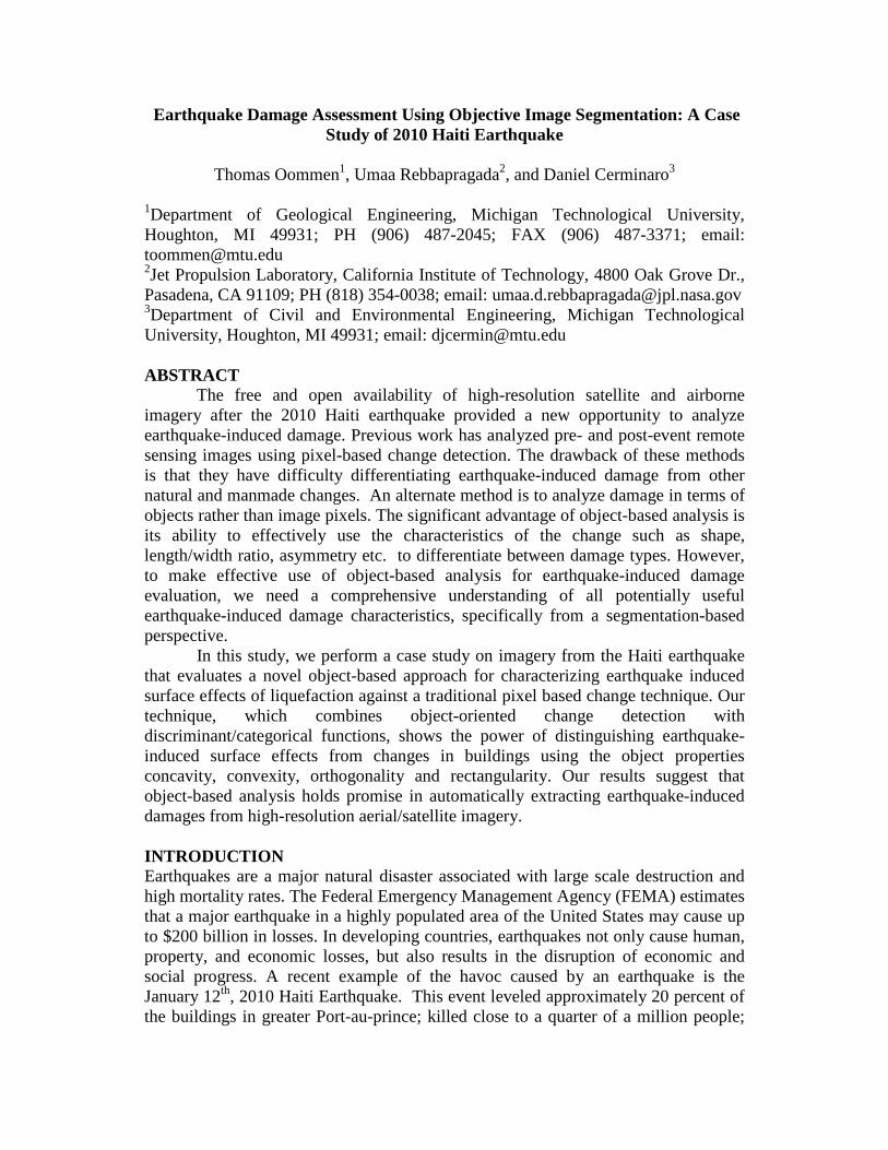
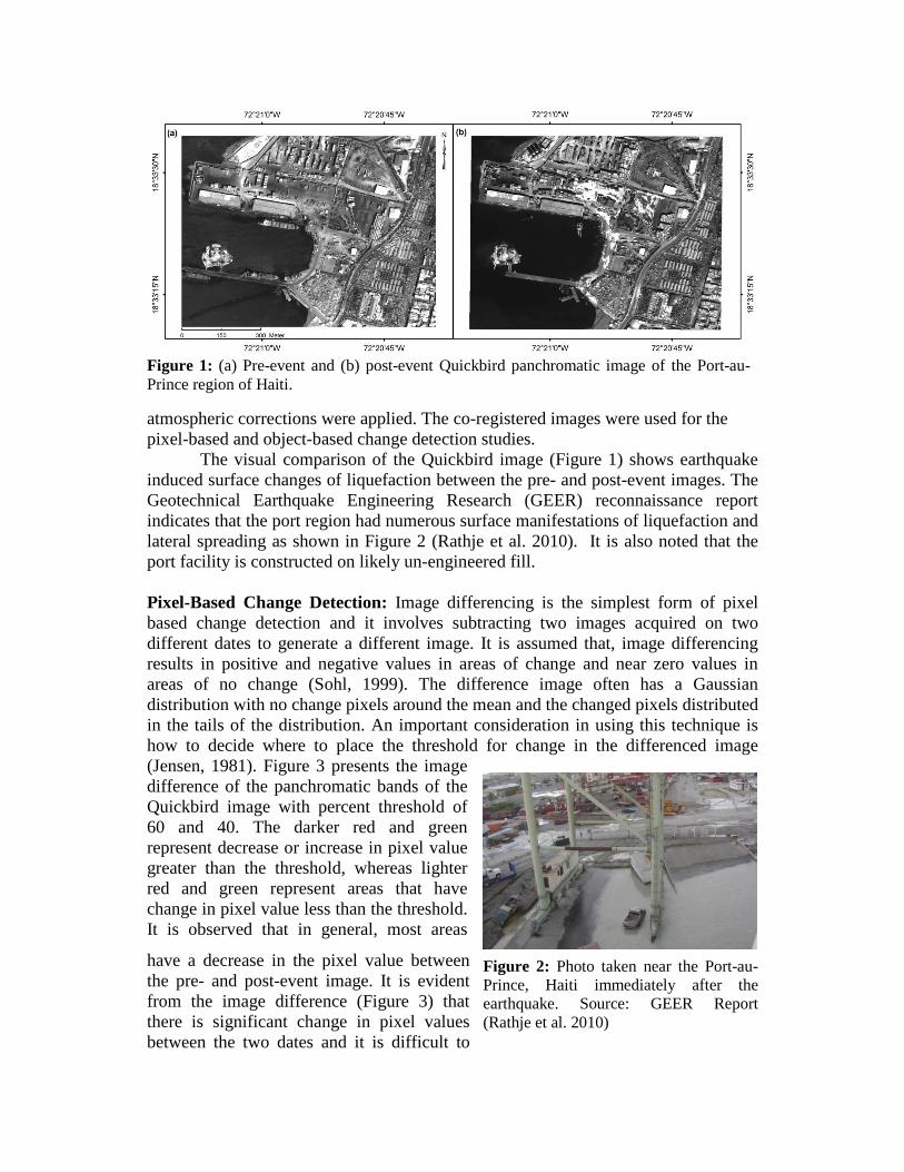
The visual comparison of the Quickbird image (Figure 1) shows earthquake induced surface changes of liquefaction between the pre- and post-event images. The Geotechnical Earthquake Engineering Research (GEER) reconnaissance report indicates that the port region had numerous surface manifestations of liquefaction and lateral spreading as shown in Figure 2 (Rathje et al. 2010). It is also noted that the port facility is constructed on likely un-engineered fill.
Pixel-Based Change Detection: Image differencing is the simplest form of pixel based change detection and it involves subtracting two images acquired on two different dates to generate a different image. It is assumed that, image differencing results in positive and negative values in areas of change and near zero values in areas of no change (Sohl, 1999). The difference image often has a Gaussian distribution with no change pixels around the mean and the changed pixels distributed in the tails of the distribution. An important consideration in using this technique is how to decide where to place the threshold for change in the differenced image (Jensen, 1981). Figure 3 presents the image difference of the panchromatic bands of the Quickbird image with percent threshold of 60 and 40. The darker red and green represent decrease or increase in pixel value greater than the threshold, whereas lighter red and green represent areas that have change in pixel value less than the threshold. It is observed that in general, most areas
have a decrease in the pixel value between the pre- and post-event image. It is evident from the image difference (Figure 3) that there is significant change in pixel values between the two dates and it is difficult to
Figure 1: (a) Pre-event and (b) post-event Quickbird panchromatic image of the Port-au-Prince region of Haiti.
Figure 2: Photo taken near the Port-au-Prince, Haiti immediately after the earthquake. Source: GEER Report (Rathje et al. 2010)

distinguish the earthquake induced surface effects from other changes based on the pixel values alone. This observation is in concurrence with earlier studies that showed that the image difference alone cannot be used for earthquake induced building damages (Rathje et al. 2005). Object-Based Change Detection Using Erdas Imagine Objective: Erdas Imagine Objective combines inferential learning with expert knowledge to emulate human visual processing by analyzing the data not just on a pixel by pixel basis but also by looking at object-based measures such as shape, size, texture, shadow, association and more. In this study, we develop a model for earthquake induced surface effects based on object-oriented change detection together with a discriminant function. The conceptual procedure of the model that we used is presented in Figure 4. The Discriminant Function Change (DFC) is a new algorithm for change detection between two co-registered images. The advantage of DFC is that the two images can have a different number of bands and wavelength characteristics. It characterizes the natural spectral clusters in the pre-event image by unsupervised classification/clustering. These clusters are used to compute the Mahalanobis Distance (MD) of the post-event image. Further, the MD is converted to a probability value based on the Chi2 look up table. The resultant is a probability image with pixel values 0.0 to 1.0 with a value of 0.0 representing no change (darker regions). The DFC image obtained in this study is presented in Figure 5a. It is evident that the DFC image identifies the earthquake induced surface effects as change (brighter regions in Figure 5a). However, these changes are not distinguishable as such from other changes that have occurred between the two dates. The real advantage of the DFC is that it provides a robust spectral probability of change per pixel which can be integrated with object based learning.
The DFC image together with the post-event image is passed through the raster pixel processor to the raster object processor for segmentation. Segmentation is an important step in the object based change detection in which the raster image is portioned into segments based on the location and the pixel value. Segmentation also identifies the edges in the image. The result from the segmentation is presented in
Figure 3: (a) Image difference between the pre- and post-event image (a) change threshold of 60% (b) change threshold of 40%.

Figure 5b. It is evident from this image that the study area is heterogeneous with several small segments. The segmentation process needs user inputs for the minimum value difference between the neighboring segments and the variation factor that
Figure 4: Conceptual procedure for automatic detection of earthquake induced surface features using object-based method together with DFC.

describes the variation in pixel values within a segment. In this study, we automatically computed these variables based on the input images. However, it is important to explore the methods to optimize these variables for different types of earthquake induced damages and surface effects. The segmented image was further analyzed using various raster object operators and converted to a vector. The raster object processor enables one to filter the segmented image based on spatial characteristics and pixel values. These operations help to filter objects with a zonal probability mean less than a specified minimum probability, dilate by combining adjacent raster objects (horizontally, vertically or diagonally) with similar pixel values, and erode by shrinking the raster object by excluding pixels in the object that have values similar to the neighboring pixels. The vector image obtained from the raster to vector conversion is further filtered using vector object operators to remove island object or lone pixels within other objects. The output of the vector object operator is presented in Figure 6a. It is observed from the vector object operator that it identifies the change objects.
Figure 6: (a) Output of the vector object operator in blue overlaid on the post-event panchromatic image (b) Output of the vector object processor and clean up operations in blue overlaid on the post-event panchromatic image.
Figure 5: (a) DFC image showing brighter areas representing probability of change. (b) segmented image.
However, these changes include earthquake induced surface effects as well as other natural changes. The natural changes identified as damages include several rooftops towards the east of the image.
We further refine the results of the vector object operator using vector object processing. The vector object processing is a critical step in differentiating the different type of vector objects based on their object properties and their association to shadow, elevation etc. We analyze the different object properties such as concavity, convexity, orthogonality, and rectangularity for the two dominant change objects identified in the output of the vector object operator namely earthquake induced surface effects and buildings.
The object property of concavity is the ratio of the objects area to its convex hull area with a maximum value of 1 for an object with no concavities. The convexity is a measure of how convex an object is and is measured by the ratio of the objects convex hulls perimeter to the object perimeter. Orthogonality is a measure of how well the object resembles an orthogonal vector object with all right angles. Whereas, rectangularity is a measure of how similar an object is to a rectangle, and is computed by the ratio of the area of the object to the area of its oriented bounding rectangle.
The distribution of these object properties for surface effects and buildings are compared using kernel density plot and presented in Figure 7. It is observed that the surface effect and buildings have distinguishable distribution for all the four object properties. The mean object property for buildings is higher than the surface effects. This indicates that the object properties represents a potentially suitable variable for use in distinguishing between earthquake induced surface effects and changes to buildings. Further, we used these object properties to refine the output of the vector object operator (Fig. 6a) and the results are presented in Figure 6b. It is observed that the resultant image is able to capture most of the earthquake induced surface effects and except for some building changes that are falsely identified.
CONCLUSION AND FUTURE WORK
In this study, we compare the traditional pixel based change detection using image differencing with object based change analysis for characterizing earthquake induced surface effects. The study was carried out using the high resolution pre- and post-event Quickbird panchromatic image from Haiti. The pixel-based approach identifies several changes between the pre- and post-event dates; however, it is not possible to distinguish the earthquake induced surface effects from other changes based on the pixel values alone. The object-based approach enables to segment the image into objects based on the location and the pixel value and analyze the object properties to characterize the change image. In this study, we develop a model for earthquake induced surface effects based on object-oriented change detection together with discriminant function. The analysis of four object properties (i.e. concavity, convexity, orthogonality, and rectangularity) show power in distinguishing earthquake induced surface effects from changes in buildings. The comparison of the two approaches indicates that the object-based approach is superior to pixel based approach in characterizing earthquake induced damages. Future work will focus on identifying the distribution of key object characteristics that distinguish various kinds

of earthquake-induced damages, with the goal of increasing the accuracy while maintaining a low rate of false detections. AKNOWLEDGEMENT We thank Patrick Florance, Manager, Geospatial Technology Services, Tufts University for sharing the Tufts Haiti image library. We also thank Ian Anderson, Director, Remote sensing products, Erdas Imagine for his support for the object-based change detection. A portion of this research was carried out at the Jet Propulsion Laboratory, California Institute of Technology, under a contract with the National Aeronautics and Space Administration (NASA). Copyright 2011. Government sponsorship acknowledged.
REFERENCES EDM. 2000. Report on the Kocaeli, Turkey Earthquake of August 17, 1999 (6). The Institute
of Physical and Chemical Research, Japan. Eguchi, R.T., Houshmand, B., Huyck, C.K., Shinozuka, M. and Tralli, D.M.. 1999. A new
application for remotely sensed data: Construction of building inventories using
Figure 7: Kernel density plot comparing the distribution of the various object properties for earthquake induced surface effects and changes in buildings.

synthetic aperture radar technology. In: Research Progress and Accomplishments, 1997-1999, MCEER-99-SP01, Multidisciplinary Center for Earthquake Engineering Research, University at Buffalo.
Eguchi, R. T., Gill, S. P., Ghosh, S., Svekla, W., Adams, B. J., Evans, G., Toro, J., Saito, K., and Spence, R. 2010. The January 12, 2010 Haiti earthquake: A comprehensive damage assessment using very high resolution areal imagery. In: 8th International Workshop on Remote Sensing for Disaster Management, Tokyo Institute of Technology, Tokyo, Japan.
Estrada, M., Matsuoka, M. and Yamazaki, F. 2000. Use of Landsat images for the identification of damage due to the 1999 Kocaeli, In: Turkey earthquake: Proceedings of the 21st Asian Conference on Remote Sensing. 2: 1185-1190.
Jensen,J. R., 1981. Urban Change Detection Mapping Using Landsat Digital data. The American Cartographer 8: 127-147.
Kerle, N. and Oppenheimer, C. 2002. Satellite remote sensing as a tool in Lahar disaster management. In: Disasters : The Journal of Disaster Studies Policy and Management, 26 (2002)2, 140-160.
Martha, T.R. and Kerle, N. 2010. Object - oriented and cognitive detection and characterization of landslides: abstract + powerpoint. In: Proceedings of the 8th International Workshop on Remote Sensing for Disaster Management, 30 September-1 October 2010, Tokyo, Japan. 2 p. + 21 slides.
Montoya, A. L. 2002. GIS and remote sensing in urban disaster management. In: Proceedings of the 5th AGILE Conference on Geographic Information Science. 25-27, April 2002, Palma, 103-107
Nichol, J. and Wong, M.S. 2005: Detection and interpretation of landslides using satellite images. Land Degradation and Development 16, 243–55.
Rathje, E.M., Crawford, M., Woo, K., and Neuenschwander, A. 2005. Damage Patterns from Satellite Images from the 2003 Bam, Iran Earthquake, Earthquake Spectra, 21(S1), S295-307.
Rathje, E.M., Bachuber, J., Cox, B., French, J., Green, R., Olson, S., Rix, G., Wells, D., and Suncar, O. 2010. Geotechnical Engineering Reconnaissance of the 2010 Haiti Earthquake, Geo-engineering Extreme Events Reconnaissance Report.
Sohl, T., L, 1999. Change Analysis in the United Arab Emirates: An Investigation of Two Techniques, Photgrammetric Engineering & Remote Sensing, 65: 475-484.
Steinle, E., Kiema, J., and Leebemann, J. 2001. Laser scanning for analysis of damages caused by earthquake hazards. In: Proceedings of the OEEPE – Workshop on Airborne Laserscanning and Interferometric SAR for Detailed Digital Elevation Models, Stockholm, 1–3 March, 2001.