dynamics of large woody debris in streams in old-growth douglas-fir forests
TRANSCRIPT
Dynamics of large woody debris in streams in old-growth Douglas-fir forests
G. W. LIENKAEMPER AND F. J. SWANSON
USDA Forest Service, Pacific Northwest Research Station, Forestry Sciences Laboratorv,3200 SW Jefferson Way, Corvallis, OR, U.S.A. 97331
Received June 6, 1986
Accepted October 29, 1986
LIENKAEMPER, G. W. , and F. J. SWANSON. 1987. Dynamics of large woody debris in streams in old-growth Douglas-fir forests.Can. J. For. Res. 17: 150-156.
Transfer of large woody debris (>10 cm diameter) from old-growth Douglas-fir (Pseudotsuga menziesii (Mirbel) Franco)forests into five first- to fifth-order stream reaches (drainage areas of 0.1 to 60.5 km 2 ) has ranged from 2.0 to 8.8 Mg • ha - I • year- Iin 7- to 9-year study periods. Amounts of large debris in these streams range from 230 to 750 Mg • ha - I , with generally lowervalues in larger channels. The addition of woody debris is widely scattered in time and space and comes mainly from single treesrooted away from the streambank. We infer that wind is a major agent for entry of wood into these streams. Downstreammovement of debris is strongly related to length of individual pieces; most pieces that moved were shorter than bankfull width.
LIENKAEMPER. G. W., et F. J. SWANSON. 1987. Dynamics of large woody debris in streams in old-growth Douglas-fir forests.Can. J. For. Res. 17 : 150-156.
Le transfert de debris ligneux grossiers (>10 cm de diametre) de vieux peuplements de douglas (Pseudotsuga menziesii(Mirbel) Franco) dans cinq biefs de ruisseaux de premier a cinquieme ordres (aires de drainage de 0,1 a 60,5 km 2 ) a varie de 2,0 a8,8 Mg • ha - I • an I sur des periodes d'etude de 7 a 9 ans. Les quantites de debris grossiers dans ces ruisseaux variaient de 230 a750 Mg • ha I , les plus faibles valeurs etant generalement associees aux plus larges cannaux. L'addition de debris ligneux estlargement repartie dans le temps et l'espace et origine surtout d'arbres individuels deracines de la berge des ruisseaux. Nous endeduisons que le vent est un agent majeur de l'entree du bois dans ces ruisseaux. Le mouvement aval des debris est fortement reliea la longueur des debris individuels; la plupart des debris qui se sont &places etaient plus courts que la largeur entre les berges.
ITraduit par la revue]
IntroductionThe transfer of large woody debris from forests to streams is a
major link between terrestrial and aquatic ecosystems. In thepast decade logs have been recognized as an important structuralcomponent of streams in forested mountainous areas and asource of nutrients for aquatic biota (Swanson eta!. 1976, 1982;Bilby and Likens 1980; Triska 1984; Triska et al. 1982, 1984).Large pieces of wood form important elements of fish habitat bycreating pools and providing cover (Bustard and Narver 1975;Bisson and Sedell 1984; Lestelle and Cederholm 1984). Woodydebris structures also retain fine particulate organic matterwhich serves as habitat and nutritional resources for somegroups of aquatic invertebrates (Triska et al. 1982; Speaker etal. 1984).
Logs are a conspicuous feature of many forested streams. Theamount of woody debris in streams strongly reflects thestructure, composition, and history of the adjacent forest. Thehighest reported quantities of woody debris (660 Mg/ha) arefound in streams draining basins of less than 1000 ha andflowing through old growth coastal redwood (Sequoia semper-virens (D. Don) Endl.) stands in north coastal California (Kelleret al. 1986). Streams of similar size flowing through other typesof old-growth coniferous forests in northwestern North Americacontain 100 to 300 Mg/ha (Harmon et al. 1986).
Despite the large quantities and biological importance ofwood in aquatic ecosystems, especially in creating fish habitat,there has been little study of the mechanisms and rates ofdelivery and redistribution. The importance of estimatingrecruitment of large woody debris to streams has increased asland managers have begun to manage streamside stands forlong-term production of lar ge woody debris for streams.Knowledge of debris stability is critical to managers chargedwith maintaining stream crossings and road networks.
Movement of pieces of wood has been observed by periodic
surveying of mapped channel sections (Swanson et a!. 1976;Megahan 1982; Toews and Moore 1982) and by relocatingmarked pieces (Bilby 1984). Swanson et al. (1976) and Kellerand Tally (1979) used dendrochronologic analysis of treesgrowing on downed trees and of stems damaged by falling treesto measure the residence time of logs in streams. These studiesrevealed that many large conifer logs have remained in place insmall streams for a century or more.
Here we report the first, long-term, direct observations ofwood input and redistribution in streams. This study of thedynamics of woody debris in streams is based on 7 to 9 years ofobservations in five stream reaches in old-growth Douglas-fir(Pseudotsuga menziesii (Mirbel) Franco) forests. This is part ofan interdisciplinary, ecosystem-scale examination of forest—stream interactions, but this discussion is limited to analysis oflog input and redistribution in mountain streams.
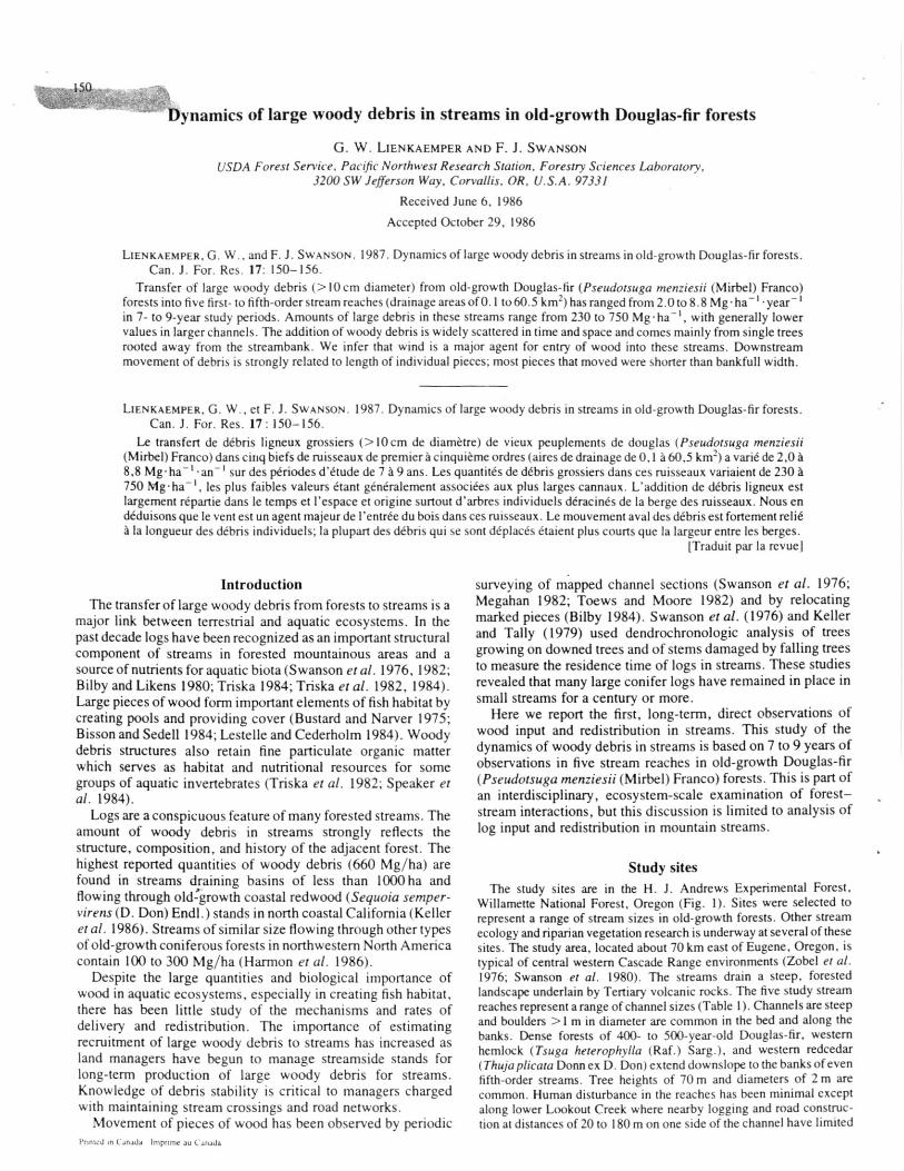
Study sitesThe study sites are in the H. J. Andrews Experimental Forest,
Willamette National Forest, Oregon (Fig. 1). Sites were selected torepresent a range of stream sizes in old-growth forests. Other streamecology and riparian vegetation research is underway at several of thesesites. The study area, located about 70 km east of Eugene, Oregon, istypical of central western Cascade Range environments (Zobel et a!.1976; Swanson et al. 1980). The streams drain a steep, forestedlandscape underlain by Tertiary volcanic rocks. The five study streamreaches represent a range of channel sizes (Table 1). Channels are steepand boulders >1 m in diameter are common in the bed and along thebanks. Dense forests of 400- to 500-year-old Douglas-fir, westernhemlock (Tsuga heterophylla (Raf.) Sarg.), and western redcedar(Thuja plicata Donn ex D. Don) extend downslope to the banks of evenfifth-order streams. Tree heights of 70 m and diameters of 2 m arecommon. Human disturbance in the reaches has been minimal exceptalong lower Lookout Creek where nearby logging and road construc-tion at distances of 20 to 180 m on one side of the channel have limited
Prtnted m Canada Imprtmc au ( anada

CA-
LIENKAEMPER AND SWANSON 151
TABLE 1. Geomorphic characteristics of study areas and year of study initiation
MeanWatershed Reach Sample Stream bankfull
Initiation Stream Elevation area length area gradient widthStudy site of study order (m) (km2) (m) (ha) (%) (m)
Watershed 9 1976 1 500 0.1 170 0.06 37 3.5Watershed 2 1976 2 550 0.8 146 0.08 26 5.2Mack Creek 1975 3 785 6.0 332 0.40 13 11.9Upper Lookout Creek 1975 3 775 11.7 483 0.75 8 15.5Lower Lookout Creek 1977 5 435 60.5 350 0.84 3 24.0
UPPERLOOKOUT
MACK4.1 WATERSHED 2 "fr
-t- CALOWER LOOKOUT
WATERSHED 9
-100 5 km OREGON
FIG. 1. Woody debris study sites are located in the H. J. AndrewsExperimental Forest, Willamette National Forest. Oregon.
the source of wood and possibly increased potential for windthrow inthe uncut forest adjacent to the stream.
Streams carry flood flows during autumn and winter (Harr 1981).Average annual precipitation is about 2500 mm. Continuously record-ing stream gauges have been operating for more than 30 years on two ofthe study streams. During our period of observation, instantaneouspeak discharges at watershed 2 ranked as the 6th (3075 L/s) and 10th ofthe 10 highest flows recorded in the period 1952-1984; in lowerLookout Creek the 4th (86 400 L/s) and 8th highest peak dischargesbetween 1950 and 1984 occurred in the period of this study.
MethodsChannel mapping
Stream channels were mapped in 1975, 1976, or 1977 (Table 1) toillustrate the distribution of individual logs and debris accumulations.Channels were mapped at a scale of 1:118 with a rangefinder and aleveling rod to locate pieces of debris and boundaries of channel units(Swanson et a!. 1976). Changes in log position and the rate ofintroduction of new logs were determined annually at Mack Creek andupper Lookout Creek and less frequently at the other sites. Minorchanges were noted on the maps from the previous year, but majorchanges in the structure of debris accumulations or channel geometryrequired complete remapping of the reach. Logs were not tagged:recognition of individual pieces from year-to-year was based on shape,location, and distinctive distinguishing characteristics of debris pieces.Some pieces of woody debris may have fallen into the wider channelsand floated downstream before sampling, but this is likely to bebalanced by input of material floated in from upstream areas.
Amount of woody debrisWoody debris, here referred to as logs -̂10 cm in diameter and
^ 1.5 m in length. was measured and mapped in and adjacent to thestream channel. The diameter at each end and the length of the piecewere recorded for pieces within the bankfull channel, as defined bychannel banks and lack of rooted trees. Root wads were not included inthe calculation of log volume. Bank-full stream width was measured at
regular intervals along each study reach. Mean width calculated fromthese measurements and length of the study reach were used todetermine the area of each study section.
Determinations of amount of large woody debris included material^ 10 cm in diameter located within the bankfull channel. The volume ofeach piece was calculated using the formula for the frustrum of aparaboloid:
Tr(D? + D)L8
where D I and D2 are the diameters at each end and L is the length. Thisequation is the product of the average diameter of the two ends andpiece length. Total volume of all pieces of woody debris divided by thesampled area yielded the volume per unit area, excluding root wads. Anassumed average specific gravity of relatively undecayed conifer wood(0.4 Mg/m 3) was multiplied by volume per unit area to estimatestanding crop.
Debris delivery to streamsStudy areas were examined in the autumn to determine the annual
delivery rate of logs. New material was noted on the maps and eachpiece tallied and measured. Delivery of logs was inventoried in terms of(i) the number of occurrences of input (an occurrence could involve allor part of one tree or more than one tree), (ii) the number of trees fromwhich pieces were derived, and ( iii) the number of pieces delivered tothe channel. Mass of material delivered per unit area was calculated anddivided by the period of observation to estimate an annual rate ofdelivery.
Each of the inventory factors has different implications. The numberof trees involved in delivering woody debris depends on structuralcharacteristics of a stand as well as on the agents of delivery. Thefrequency of tree fall is an important aspect of stand dynamics. Thestream channel responds to the number and size of pieces that resultfrom delivery and related breakage.
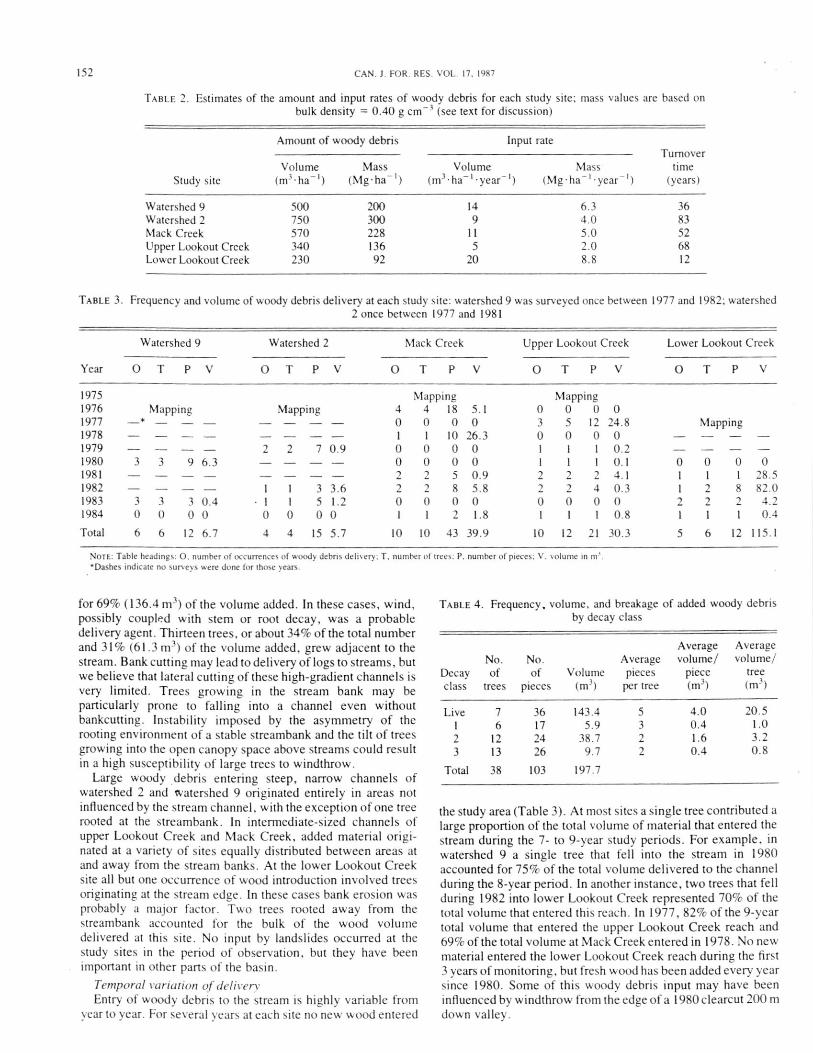
ResultsAmount of large woody debris
The amount of large woody debris was measured during thefirst year of monitoring at each study site (Table 2). Valuesranged from 92 Mg/ha at lower Lookout Creek to 300 Mg/ha atwatershed 2. These quantities were typical of those measured inother streams of similar size flowing through mature coniferousforests in the Pacific Northwest, but less than in coastal redwoodforests (Harmon et al. 1986). Amounts of large woody debris inthe streams generally decreased from small to large channels.
Debris deliverySource location and agents of deliveryRooting locations of trees that were sources of wood entering
stream channels set limits on interpretation of the agents ofdelivery. Portions of 38 trees entered the study reaches duringthe sample period (Table 3). Twenty-five of these trees (66%)were growing in areas not subject to bank erosion and accounted
111 Volume —
152
CAN. J. FOR. RES. VOL. 17. 1987
TABLE 2. Estimates of the amount and input rates of woody debris for each study site; mass values are based onbulk density = 0.40 g cm -3 (see text for discussion)
Amount of woody debris
Input rateTurnover
Volume Mass time(m 3 • ha -1 • year .-(Mg • ha I • year - ) (years)Study site
Volume Mass(m 3 •ha -/ ) (Mg•ha-1)
Watershed 9 500 200 14 6.3 36Watershed 2 750 300 9 4.0 83Mack Creek 570 228 11 5.0 52Upper Lookout Creek 340 136 5 2.0 68Lower Lookout Creek 230 92 20 8.8 12
TABLE 3. Frequency and volume of woody debris delivery at each study site: watershed 9 was surveyed once between 1977 and 1982; watershed2 once between 1977 and 1981
Year
Watershed 9 Watershed 2 Mack Creek Upper Lookout Creek Lower Lookout Creek
0 T PV 0 T PV 0 T P V 0 T P V OT P V
1975 Mapping Mapping1976 Mapping Mapping 4 4 18 5.1 0 0 0 01977 -* - - - - - - 0 0 0 0 3 5 12 24.8 Mapping1978 1 I 10 26.3 0 0 0 0 - -1979 - - - - 2 2 7 0.9 0 0 0 0 1 I I 0.2 - - -1980 3 3 9 6.3 0 0 0 0 1 1 I 0.1 0 0 0 01981 - - - - 2 2 5 0.9 2 2 2 4.1 1 1 1 28.51982 - - - - 1 1 3 3.6 2 2 8 5.8 2 2 4 0.3 1 2 8 82.01983 3 3 3 0.4 1 1 5 1.2 0 0 0 0 0 0 0 0 2 2 2 4.21984 0 0 0 0 0 0 0 0 1 1 2 1.8 I 1 1 0.8 1 1 1 0.4
Total 6 6 12 6.7 4 4 15 5.7 10 10 43 39.9 10 12 21 30.3 5 6 12 115.1
NOTE: Table headings: O. number of occurrences of woody debris delivery: T. number of trees: P. number of pieces: V, volume in ni.'Dashes indicate no surveys were done for those years.
for 69% (136.4 m 3 ) of the volume added. In these cases, wind,possibly coupled with stem or root decay, was a probabledelivery agent. Thirteen trees, or about 34% of the total numberand 31% (61.3 m 3 ) of the volume added, grew adjacent to thestream. Bank cutting may lead to delivery of logs to streams, butwe believe that lateral cutting of these hi gh-gradient channels isvery limited. Trees growing in the stream hank may beparticularly prone to falling into a channel even withoutbankcutting. Instability imposed by the asymmetry of therooting environment of a stable streambank and the tilt of treesgrowing into the open canopy space above streams could resultin a high susceptibility of large trees to windthrow.
Large woody . debris entering steep, narrow channels ofwatershed 2 and watershed 9 originated entirely in areas notinfluenced by the stream channel, with the exception of one treerooted at the streambank. In intermediate-sized channels ofupper Lookout Creek and Mack Creek, added material origi-nated at a variety of sites equall y distributed between areas atand away from the stream banks. At the lower Lookout Creeksite all but one occurrence of wood introduction involved treesoriginating at the stream edge. In these cases bank erosion wasprobably a major factor. Two trees rooted away from thestreanthank accounted for the hulk of the wood volumedelivered at this site. No input by landslides occurred at thestudy sites in the period of observation. but they have beenimportant in other parts of the basin.
Temporal variation of deliveryEntry of woody debris to the stream is highly variable from
year to year. For several years at each site no new wood entered
TABLE 4. Frequency, volume, and breakage of added woody debrisby decay class
Average Averagevolume/ volume/
piece tree(m 3 ) (m3)
7 36 143.4 56 17 5.9 3
12 24 38.7 213 26 9.7 2
38 103 197.7
the study area (Table 3). At most sites a single tree contributed alarge proportion of the total volume of material that entered thestream during the 7- to 9-year study periods. For example. inwatershed 9 a single tree that fell into the stream in 1980accounted for 75% of the total volume delivered to the channelduring the 8-year period. In another instance, two trees that fellduring 1982 into lower Lookout Creek represented 70% of thetotal volume that entered this reach. In 1977, 82% of the 9-yeartotal volume that entered the upper Lookout Creek reach and69% of the total volume at Mack Creek entered in 1978. No newmaterial entered the lower Lookout Creek reach during the first3 years of monitoring, but fresh wood has been added every yearsince 1980. Some of this woody debris input may have beeninfluenced by windthrow from the edge of a 1980 clearcut 200 mdown valley.
No. No. AverageDecay of of Volume piecesclass trees pieces (m3)
per tree
Live123
Total
4.0 20.5
0.4 1.0
1.6 3.2
0.4 0.8

LIENKAEMPER AND SWANSON
TABLE 5. Summary of woody debris delivery and redistribution by study site
153
No. of No. ofDate of No. of
pieces moved pieces added
No. of
first pieces between first between first added pieces
Study site map mapped
map and 1984 map and 1984 that moved
Watershed 9 1976 80 5 12 0Watershed 2 1976 87 7 15 0Mack Creek 1975 106 53 43 18Upper Lookout Creek 1975 305 40 21 5Lower Lookout Creek 1977 46 30 12 6
Stage of decomposition and breakage of logsWoody debris entering the stream channel was classified
according to a modification of the Fogel et al. (1972) decayclass system. Logs in decay class 1 had intact bark, twigs of lessthan 3 cm diameter, and wood with no decay stains. Logs indecay class 2 had lost twigs and some bark and sapwood wassoft. Logs in decay class 3 were only partially intact withsloughing bark and red-brown wood. Trees or portions of treesthat were living when they fell were also noted.
Freshly killed trees made up 73% of the volume but only 18%of trees added at all sites during the study (Table 4). Decay class2 made up 19% of the volume, and classes 3 and 1 accounted for5% and 3%, respectively. Freshly killed trees broke into thehighest number of pieces (5) per tree (Table 4). The number ofpieces produced per fallen tree or snag decreased slightly withincreasing stage of decay.
RedistributionThe greatest redistribution of woody debris occurred in larger
streams during the monitoring period (Table 5). Less than 10%of the pieces identified on the original maps were detected tohave moved during the 8 years of observation at watershed 2 andwatershed 9 (downstream or rotational movement of more than1 m was easily detected). None of the material added to thesestreams during that period moved. Just over 10% of the piecesoriginally surveyed in upper Lookout Creek moved during thestudy period, and 24% of the material added in 9 years wasredistributed. Of the debris pieces first mapped in lowerLookout Creek, 65% was redistributed between 1978 and 1984,and half of the material added during that period has movedsince it was introduced.
Since Mack Creek had been mapped in detail before a highflow in November 1977 moved many pieces of woody debris,we were able to develop a detailed description of redistributionof woody material. Because the stream gauge on Mack Creekwas not operational at the time of the high flow, we used datafrom other stream gauges and other information to estimate areturn interval of 10 years. Snow conditions in the Mack Creekbasin may have resulted in flows of greater return interval thanin other basins in the H. J. Andrews Experimental Forest.However, the greater mobility of debris in Mack Creek duringthis event, relative to other study sites, may have resultedprimarily from the breakup of a single debris jam: releasingpieces which triggered downstream changes. The high flowmoved half of the pieces in the Mack Creek study site by 1978.None have moved since. Of the 18 pieces that fell into MackCreek during the monitoring period before the November 1977flow, 16 moved before 1978. Between 1978 and 1984 only 2 of25 new pieces of wood that entered Mack Creek wereredistributed.
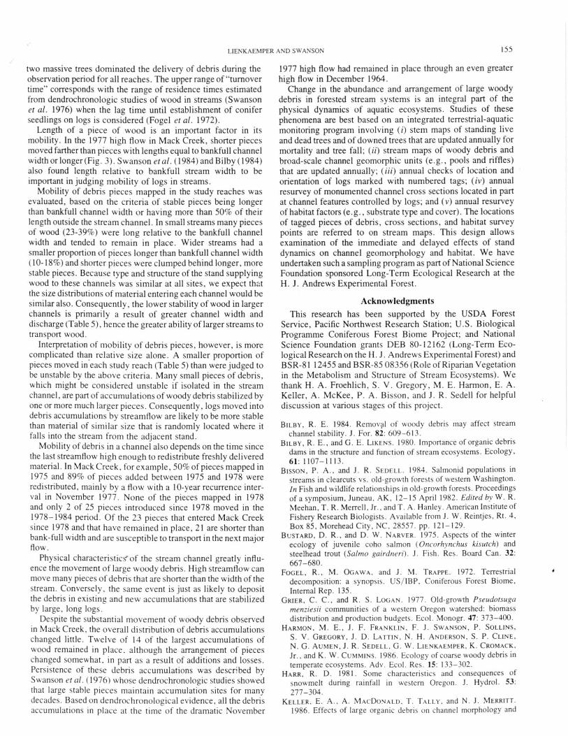
Woody debris was transported through a 220 m long zone in
Mack Creek where log movement was severely restricted at theupstream and downstream ends. A large debris jam located atthe upstream end of this zone trapped material transported fromfarther upstream. During the high flow, water ponded behind aroadfill at the downstream end of the zone, and most of thematerial that moved out of the section was trapped in theresulting pond. Transported woody debris also accumulated atseveral areas between the upper jam and the pond.
Many pieces exported from the reach and deposited at theroadfill were recognizable by size, shape, bark pattern, andother characteristics. Their positions before high flow anddistances transported could be determined from stream mapsand observations of researchers familiar with the site. Werelocated 70 pieces of woody debris that appeared on mapsprepared before high flow (Fig. 2A). Of these, 28 piecesremained in place and 42 were transported varying distancesdownstream. Most of the transported pieces accumulated in thepond behind the roadfill below the study section and at the debrisaccumulation at the left-hand end of Fig. 2A. For example. thelog that keyed the debris accumulation highlighted in black(Fig. 2A) was broken, and most of the material that accumulatedbehind it floated out of the section. Black, highlighted logs (Fig.2B) show where a few pieces were deposited. Although mostpieces floated into place, the streamward ends of several logsthat were anchored outside the stream channel pivoted a fewmetres downstream, e.g., a stippled log in Fig. 2B. Some pieceswere buried within major accumulations and were not tallied.
Pieces of woody debris that remained stationary wereanchored in some way or were protected from high streamflowby anchored pieces. Root wads anchored five (19%) of thepieces that did not move. Another 44% were anchored on thestreambank by part of their mass. The remaining 37% of thestationary pieces were protected by anchored pieces. The meanlength of pieces anchored by rootwads was 15.4 m and protectedpieces had a mean length of 6.0 m. The seven pieces anchoredon the bank by 50% or less of their length had a mean length of7.6 m, and the five pieces that had more than 50% of their lengthoutside of the stream channel averaged twice that length(15.2 m).
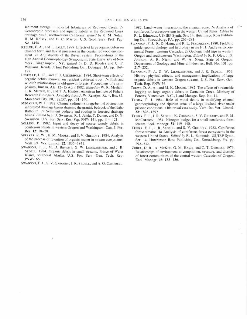
The distance a piece moved in the November 1977 high flowdepended greatly on the length of the piece in relation tobankfull width (Fig. 3). All 30 pieces moving more than 10 mwere shorter than 1 1 m; average bankfull width was 11.9 m.Several longer pieces moved less than 10 m by pivoting orturning on points located on adjacent hillslopes.
DiscussionThe locations of trees that supplied wood to the study reaches
offer some insight to agents of woody debris introduciton. Treesrooted at the streambank can enter the channel as a result of

UNDERCUT BANKROOTS IN STREAMBANK
- WATER FLOWACTIVE CHANNEL
A FLOATED ORGANIC DEBRIS0 LIVING TREE
-• LARGE ORGANIC DEBRIS- CHANNEL BOUNDARY
® 1978
E
MID CDLU02 60
cn
40 00 AVERAGE BANKFULL
CHANNEL WIDTH
154 CAN. J. FOR. RES. VOL. 17. 1987
C) 1975
FIG. 2. The November 1977 high flow redistributed a large amount of wood in Mack Creek. For example. most of the material highlighted inblack (A) was washed out of the study area, but some material was redeposited at the next bend (black pieces in B). The stippled log in A broke andpivoted downstream.
0 FLOATED TO NATURALPOSITION
too 0 0 A FLOATED TO ROADFILL0 PIVOTED ON POINT ON
BANK
20 0
akD5 10 15
PIECE LENGTH (m)FIG. 3. Unanchored logs that were shorter than bankfull width were
redistributed in the November 1977 high flow at Mack Creek.
lateral cutting by the stream. Wind and other factors, such asasymmetry of a root mass developed in the bank environment,might also lead to introduction of trees rooted at the streammargin, even in the absence of bank cutting. Lateral cutting inthe study reaches appeared to he rare: the presence of 400- to
500-year-old trees along the banks indicated that channelmigration has been minimal. Consequently, the large propor-tion of woody debris added from trees growing away from thestream channel, coupled with complex root and crown environ-ments of streamside trees, led us to conclude that wind (perhapspredisposed by decay and other factors) has been the mostprominent agent of delivery of wood to the studied streamchannels. Elsewhere in the basin debris slides and earthflowshave been localized sources of woody debris for stream reaches.
Amounts and delivery rates of woody debris in streams aresimilar to estimates of woody debris in nearby forest stands.For Douglas-fir forests similar in age to those in our sites, otherstudies reported values of 80-190 Mg/ha (Grier and Logan1977: Sollins 1982; Harmon et al. 1986). Input rates to theforest floor as reported in the same studies ranged from 4.5 to7.0 Mg • ha -I. year -1 . Woody debris delivery rates for sitessampled in this study (2.0-8.8 Mg ha- ' year -I ) and standingcrop estimates (92-300 Mg/ha) were similar to forest floorvalues. Variation in delivery rate among and within stream sitesand upland forest areas is partly a result of the shortness ofrecord.
An index of the residence time of woody debris is the"turnover time," calculated as the standing crop divided by thedelivery rate (Table 2). The broad range of estimates of turnovertime (12-83 years) is in part a result of the short period ofrecord. The 9-year record, for example. is less than 10% of thetime required for complete decomposition of an individual logfrom an old-growth tree in these streams (Swanson et al. 1976).Because of the small sample size, the introduction of only one or
E80 0
0 0
20
LIENKAENIPER AND SWANSON 155
two massive trees dominated the delivery of debris during theobservation period for all reaches. The upper range of "turnovertime" corresponds with the range of residence times estimatedfrom dendrochronologic studies of wood in streams (Swansonet al. 1976) when the lag time until establishment of coniferseedlings on logs is considered (Fogel et al. 1972).
Length of a piece of wood is an important factor in itsmobility. In the 1977 high flow in Mack Creek, shorter piecesmoved farther than pieces with lengths equal to bankfull channelwidth or longer (Fig. 3). Swanson et al. (1984) and Bilby (1984)also found length relative to bankfull stream width to beimportant in judging mobility of logs in streams.
Mobility of debris pieces mapped in the study reaches wasevaluated, based on the criteria of stable pieces being longerthan bankfull channel width or having more than 50% of theirlength outside the stream channel. In small streams many piecesof wood (23-39%) were long relative to the bankfull channelwidth and tended to remain in place. Wider streams had asmaller proportion of pieces longer than bankfull channel width(10-18%) and shorter pieces were clumped behind longer, morestable pieces. Because type and structure of the stand supplyingwood to these channels was similar at all sites, we expect thatthe size distributions of material entering each channel would besimilar also. Consequentl y , the lower stability of wood in largerchannels is primarily a result of greater channel width anddischarge (Table 5), hence the greater ability of larger streams totransport wood.
Interpretation of mobility of debris pieces. however, is morecomplicated than relative size alone. A smaller proportion ofpieces moved in each study reach (Table 5) than were judged tobe unstable by the above criteria. Many small pieces of debris,which might be considered unstable if isolated in the streamchannel, are part of accumulations of woody debris stabilized byone or more much larger pieces. Consequently, logs moved intodebris accumulations by stream flow are likely to be more stablethan material of similar size that is randomly located where itfalls into the stream from the adjacent stand.
Mobility of debris in a channel also depends on the time sincethe last streamflow high enough to redistribute freshly deliveredmaterial. In Mack Creek, for example, 50% of pieces mapped in1975 and 89% of pieces added between 1975 and 1978 wereredistributed, mainl y by a flow with a 10-year recurrence inter-val in November 1977. None of the pieces mapped in 1978and only 2 of 25 pieces introduced since 1978 moved in the1978-1984 period. Of the 23 pieces that entered Mack Creeksince 1978 and that have remained in place, 21 are shorter thanbank-full width and are susceptible to transport in the next majorflow.
Physical characteristics' of the stream channel greatly influ-ence the movement of large woody debris. High streamflow canmove many pieces of debris that are shorter than the width of thestream. Conversely, the same event is just as likely to depositthe debris in existing and new accumulations that are stabilizedby large, long logs.
Despite the substantial movement of woody debris observedin Mack Creek. the overall distribution of debris accumulationschanged little. Twelve of 14 of the largest accumulations ofwood remained in place. although the arrangement of pieceschanged somewhat, in part as a result of additions and losses.Persistence of these debris accumulations was described bySwanson et al. (1976) whose dendrochronologic studies showedthat large stable pieces maintain accumulation sites for manydecades. Based on dendrochronological evidence, all the debrisaccumulations in place at the time of the dramatic November
1977 high flow had remained in place through an even greaterhigh flow in December 1964.
Change in the abundance and arrangement of large woodydebris in forested stream systems is an integral part of thephysical dynamics of aquatic ecosystems. Studies of thesephenomena are best based on an integrated terrestrial-aquaticmonitoring program involving (i) stem maps of standing liveand dead trees and of downed trees that are updated annually formortality and tree fall; (ii) stream maps of woody debris andbroad-scale channel geomorphic units (e.g., pools and riffles)that are updated annually; (iii) annual checks of location andorientation of logs marked with numbered tags; (iv) annualresurvey of monumented channel cross sections located in partat channel features controlled by logs; and (v) annual resurveyof habitat factors (e.g., substrate type and cover). The locationsof tagged pieces of debris, cross sections, and habitat surveypoints are referred to on stream maps. This design allowsexamination of the immediate and delayed effects of standdynamics on channel geomorphology and habitat. We haveundertaken such a sampling program as part of National ScienceFoundation sponsored Long-Term Ecological Research at theH. J. Andrews Experimental Forest.
AcknowledgmentsThis research has been supported by the USDA Forest
Service, Pacific Northwest Research Station; U.S. BiologicalProgramme Coniferous Forest Biome Project; and NationalScience Foundation grants DEB 80-12162 (Long-Term Eco-logical Research on the H. J. Andrews Experimental Forest) andBSR-81 12455 and BSR-85 08356 (Role of Riparian Vegetationin the Metabolism and Structure of Stream Ecosystems). Wethank H. A. Froehlich, S. V. Gregory, M. E. Harmon, E. A.Keller, A. McKee, P. A. Bisson, and J. R. Sedell for helpfuldiscussion at various stages of this project.
BILBY, R. E. 1984. Removal of woody debris may affect streamchannel stability. J. For. 82: 609-613.
B ILBY, R. E., and G. E. L IKENS. 1980. Importance of organic debrisdams in the structure and function of stream ecosystems. Ecology,61: 1107-1113.
B ISSON, P. A., and J. R. SEDELL. 1984. Salmonid populations instreams in clearcuts vs. old-growth forests of western Washington.In Fish and wildlife relationships in old-growth forests. Proceedingsof a symposium, Juneau, AK, 12-15 April 1982. Edited by W. R.Meehan, T. R. Merrell. Jr., and T. A. Hanley. American Institute ofFishery Research Biologists. Available from J. W. Reintjes, Rt. 4,
Box 85, Morehead City, NC, 28557. pp. 121-129.
B USTARD, D. R.. and D. W. N ARVER. 1975. Aspects of the winterecology of juvenile coho salmon (Oncorhvnchus kisutch) andsteelhead trout (Salta° gairdneri). J. Fish. Res. Board Can. 32:
667-680.
FOGEL, R.. M. OGAWA, and J. M. TRAPPE. 1972. Terrestrialdecomposition: a synopsis. US/IBP. Coniferous Forest Biome,Internal Rep. 135.
G RIER, C. C.. and R. S. LOGAN. 1977. Old-growth Pseudotsuga?nen:iesii communities of a western Oregon watershed: biomassdistribution and production budgets. Ecol. Monogr. 47: 373-400.
H ARMON. M. E., J. F. FRANKLIN. F. J. SWANSON, P. SOLLINS,
S. V. G REGORY, J. D. LATTIN, N. H. ANDERSON. S. P. CLINE,
N. G. A UMEN, J. R. SEDELL, G. W. LIENKAEMPER, K. CROIMACK,
Jr.. and K. W. C UMMINS. 1986. Ecology of coarse woody debris intemperate ecosystems. Adv. Ecol. Res. 15: 133-302.
HARR. R. D. 1981. Some characteristics and consequences ofsnowmelt during rainfall in western Oregon. J. Hydrol. 53:277-304.
KELLER. E. A., A. M ACDONALD. T. TALLY. and N. J. M ERRITT.
1986. Effects of large organic debris on channel morphology and
156
CAN. J. FOR. RES. VOL. 17. 1987
sediment storage in selected tributaries of Redwood Creek. InGeomorphic processes and aquatic habitat in the Redwood Creekdrainage basin, northwestern California. Edited by K. M. Nolan,H. M. Kelsey, and D. C. Marron. U.S. Geol. Surv. Prof. Pap.No. 1454.
KELLER, E. A., and T. TALI.Y. 1979. Effects of large organic debris onchannel form and fluvial processes in the coastal redwood environ-ment. In Adjustments of the fluvial system. Proceedings of the10th Annual Geomorphology Symposium, State University of NewYork, Binghampton, NY. Edited by D. D. Rhodes and G. P.Williams. Kendall/Hunt Publishing Co., Dubuque, IA. pp. 169-197.
LESTELLE, L. C., and C. J. CEDERHOLM. 1984. Short-term effects oforganic debris removal on resident cutthroat trout. In Fish andwildlife relationships in old-growth forests. Proceedings of a sym-posium, Juneau, AK, 12-15 April 1982. Edited by W. R. Meehan,T. R. Merrell, Jr., and T. A. Hanley. American Institute of FisheryResearch Biologists. Available from J. W. Reintjes, Rt. 4, Box 85,Morehead City, NC, 28557. pp. 131-140.
MEGAHAN, W. F. 1982. Channel sediment storage behind obstructionsin forested drainage basins draining the granitic bedrock of the IdahoBatholith. In Sediment budgets and routing in forested drainagebasins. Edited by F. J. Swanson, R. J. Janda, T. Dunne, and D. N.Swanston. U.S. For. Serv. Res. Pap. PNW-141. pp. 114-121.
SOLLINS, P. 1982. Input and decay of coarse woody debris inconiferous stands in western Oregon and Washington. Can. J. For.Res. 12: 18-28.
SPEAKER, R. W., K. M. MOORE, and S. V. GREGORY. 1984. Analysisof the process of retention of organic matter in stream ecosystems.Verh. Int. Ver. Limnol. 22: 1835-1841.
SWANSON, F. J., M. D. BRYANT, G. W. LIENKAEMPER, and J. R.SEDELL. 1984. Organic debris in small streams. Prince of WalesIsland, southeast Alaska. U.S. For. Serv. Gen. Tech. Rep.PNW-166.
SWANSON, F. J., S. V. GREGORY, J. R. SEDELL, and A. G. CAMPBELL.
1982. Land-water interactions: the riparian zone. In Analysis ofconiferous forest ecosystems in the western United States. Edited byR. L. Edmonds. US/IBP Synth. Ser. 14. Hutchinson Ross Publish-ing Co., Stroudsburg, PA. pp. 267-291.
SWANSON, F. J.. R. D. HARR, and R. L. FREDRIKSEN. 1980. Field tripguide: geomorphology and hydrology in the H. J. Andrews Experi-mental Forest, western Cascades. In Geologic field trips in westernOregon and southwestern Washington. Edited by K. F. Oles, J. G.Johnson, A. R. Niem, and W. A. Niem. State of Oregon,Department of Geology and Mineral Industries, Bull. No. 101. pp.217-232.
SWANSON, F. J.. G. W. LIENKAEMPER, and J. R. SEDELL. 1976.History, physical effects, and management implications of largeorganic debris in western Oregon streams. U.S. For. Serv. Gen.Tech. Rep. PNW-56.
TOEWS, D. A. A., and NI. K. MOORE. 1982. The effects of streamsidelogging on large organic debris in Carnation Creek. Ministry ofForests, Vancouver. B.C.. Land Manage. Rep. No. 11.
TRISKA, F. J. 1984. Role of wood debris in modifying channelgeomorphology and riparian areas of a large lowland river underpristine conditions: a historical case study. Verh. Int. Ver. Limnol.22: 1876-1892.
TRISKA, F. J., J. R. SEDELI., K. CROMACK, S. V. GREGORY, and F. M.McCoRtsoN. 1984. Nitrogen budget for a small coniferous foreststream. Ecol. Monogr. 54: 119-140.
TRISKA, F. J., J. R. SEDELL, and S. V. GREGORY. 1982. Coniferousforest streams. In Analysis of coniferous forest ecosystems in thewestern United States. Edited by R. L. Edmonds. US/IBP Synth.Ser. 14. Hutchinson Ross Publishing Co., Stroudsburg, PA. pp.292-332.
ZOBEL, D. B., A. McKEE, G. M. HAWK, and C. T. DYRNESS. 1976.Relationships of environment to composition. structure, and diversityof forest communities of the central western Cascades of Oregon.Ecol. Monogr. 46: 135-156.