dutchman flat area nordic ski and snowshoe trails · 2018-09-03 · common- corridor w0.5 miles...
TRANSCRIPT
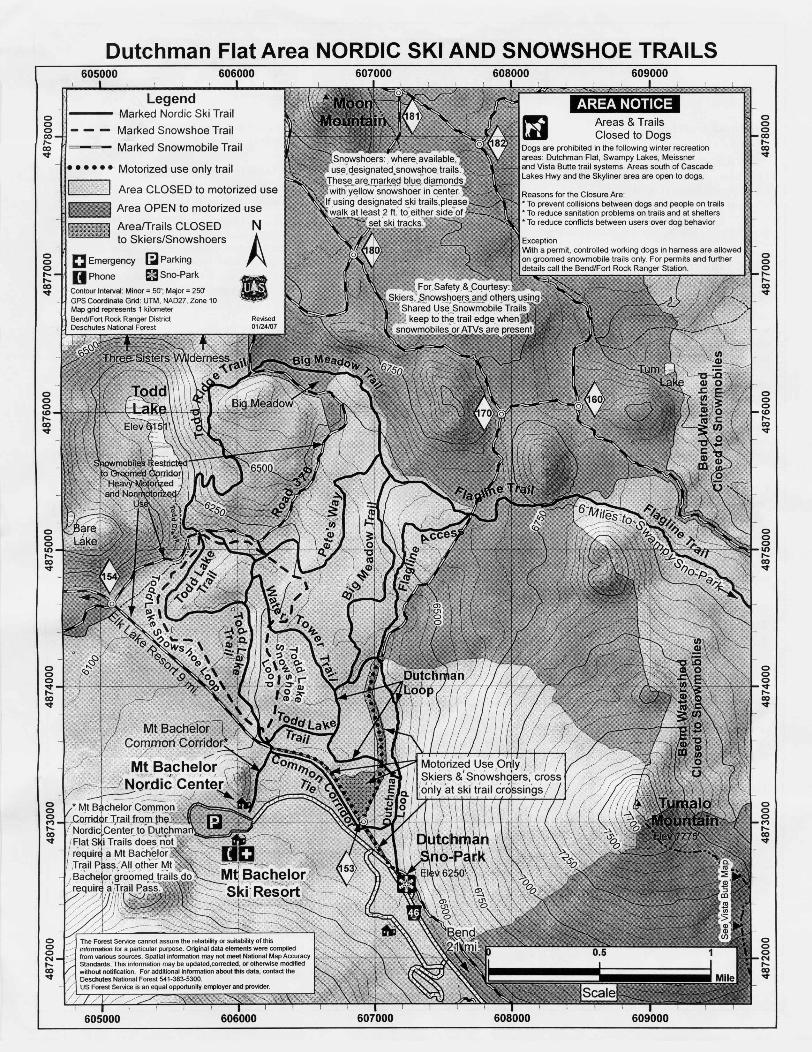
Dutchman Flat Area NORDIC SKI AND SNOWSHOE TRAILS605000 606000 607000 608000 609000
oooco,...co'<t
LegendMarked Nordic Ski TrailMarked Snowshoe TrailMarked Snowmobile Trail
AREA NOTICEoooco,...IX)'<t
ooo,...,...co'<t
• • • • •• Motorized use only trail
-c=J Area CLOSED to motorized use_ Area OPEN to motorized use
AreafTrails CLOSED Nto Skiers/Snowshoers A
C Emergency [:;J ParkingUPhone sa Sno-Park II
Contour Interval: Minor = 50'; Major = 250' 'GPS Coordinate Grid: UTM, NAD27, Zone 10 '--v--'Map grid represents 1 kilometerBend/Fort Rock Ranger DistrictDeschutes National Forest
Areas & TrailsClosed to Dogs
Dogs are prohibited in the following winter recreationareas: Dutchman Flat, Swampy Lakes, Meissnerand Vista Butte trail systems, Areas south of CascadeLakes Hwy and the Skyliner area are open to dogs,
Reasons for the Closure Are:• To prevent collisions between dogs and people on trails• To reduce sanitation problems on trails and at shelters• To reduce conflicts between users over dog behavior
ExceptionWith a permit, controlled working dogs in hamess are allowedon groomed snowmobile trails only. For permits and furtherdetails call the Bend/Fort Rock Ranger Station,
ooo,...,...CO'<t
ooo(Q,...CO'<t
ooo(Q,...co'<t
ooo10,...CO'<t
ooo10,...CO'<t
ooo'<tr--CO'<t
ooo~co'<t
oooMr--CO'<t
oooNr--CO'<t
oooNr--CO'<t
605000 606000 607000 608000 609000

Common Corridor-W 0.5 milesThis route links the Mt. Bachelor Nordic Centerwith Cascade Lakes Hwy. The trail isdesignated as a common corridor to allow skiersto travel from the Mt. Bachelor Ski Area to theForest Service Nordic trail system at no charge.
Todd Lake Trail:S3.3 milesThe trail begins at Dutchman Loop and goeswest. This more difficult trail has some excitingchallenges, and is a good alternative to theheavily used Cascade Lakes Hwy and Road 370Trails. From the Mt. Bachelor Access, the traildescends much of the way to the intersectionwith Road 370. Continuing to Todd Lake, thetrail climbs gradually for a short distance andmakes a loop (unmarked) around the lake. It isrecommended to travel around the lake in aclockwise direction, and to stay off the ice.
Common Corridor Tie-W 0.6mileThis trail provides a more direct route fromDutchman Sno-Park to Mt. Bachelor NordicCenter. Be aware of the "motorized only" areasand trails as noted on the map
Water Tower Trail
S1.2 milesThe most direct access is from Dutchman Loop.The grade is gentle except for two steep sectionsas it follows through sparse mountain hemlockto within about 100 feet of the Mt. Bachelorwater tower. The trail then crosses a bridge toan open meadow. Beyond the meadow, the traildescends westerly a short distance to intersectRoad 370.
Road 370 Trail:S2.2 milesRoad 370 is a groomed snowmobile trailstarting at Cascade Lakes Highway andextending to the east side of Three Creek Lake.Road 370 is a shared corridor trail used jointlyby Nordic skiers, snowmobilers, dog sledders,
and snowshoers. Nonmotorized users shouldyield the right-or-way to the motorizedtraveler. The first Y2 mile follows flat terrain toTodd Lake junction. The next I 'A miles areuphill to Big Meadow. At Big Meadow, thetrail goes northwest until it intersects the BigMeadow Trail. From Big Meadow the views ofMt. Bachelor are spectacular. Because of trailcongestion, and some steep fast pitches, allusers should exercise caution when comingdown this route.
Todd Ridge Trail~~ 1.0mile
This trail offers some steep challenges, rising350 feet before it joins the Big Meadow Trail.It may be accessed at Todd Lake or at BigMeadow. Novices should approach from ToddLake, as it is easier to traverse up the steep sideridge rather than down. But if you are theexpert skier looking for a steep continuousdowngrade through the trees, this is the trail foryou.
Pete's Way~~ 1.0 mile
Access this trail from the Water Tower Trailapproximately 35 yards northwest of the watertower. It continues up moderately steep terrainfor the first Y2 mile. The remaining Y2 mile isgentle until it intersects the Big Meadow Trail.
Big Meadow Trail:S2.3 milesThis trail starts at Dutchman Loop and is one ofthe primary access routes to the Three SistersWilderness. From Dutchman Flat the trailgradually ascends through mountain hemlockwith few openings along the way to BigMeadow. It connects with the Todd Ridge Trailacross Road 370.
Flagline Trail~~~" 8.0 milesThis trail begins at the Big Meadow Trail andtravels north ofTumalo Mountain ending at theSwampy Lakes shelter. Using a car shuttle, aski tour of about 8 miles from Dutchman Sno-Park to Swampy Sno-Park can take 4-6 hours toaccomplish. This trip should only be attempted
in good weather. The route crosses snowmobiletrails two times.
Flagline Access
~~i:.6i ~ 1.0 mileThis trail branches off Dutchman Loop at thenortheastern comer of Dutchman Flat andtravels north through dense hemlock until it hitsFlagline Trail. The route is all uphill andprovides very few scenic views, but it providesa loop opportunity as well as alternative accessto the Three Sisters Wilderness.
Todd Lake Snowshoe Trail
~~i:.6i ~ 2.8 milesThis designated snowshoe trail (notrecommended for skiing) can be hiked as an outand back or as a loop. Access is from the Mt.Bachelor Common Corridor with the trailstarting at the Common Corridor nordictrailhead information board. The trail leads thruforests of lodgepole pine and stands of largemountain hemlock and crosses two meadows.
i~[.);4n [41~itk~(IWki:(.)i i;1'" iitilliiiijI. Match your abilities and experience with your
trip plans.2. Do not snowshoe or walk over a ski track.
When snowshoeing on ski trails, please walk atleast 2 ft. to either side of the set ski tracks toavoid ruining them.
3. Keep to the right when meeting another skier.When stopped, do not block the trail.
4. Yield the right of way to the descending skier.5. If an accident occurs, everyone should render
necessary assistance. Witnesses should establishtheir identities.
6. Respect the rights of all winter users. Do notinterfere with or harass others. People mayjudge all skiers or snowmobilers by oneindividual's actions.
7. Do not litter. If you pack it in, pack it out.8. Please ski to the right on shared use trails to
allow snowmobiles to pass safely.9. Please respect areas closed to dogs. If you visit
areas open to dogs, follow canine courtesy.10. Shelter policy - Day Use only. No overnight
camping - overnight use exhausts wood rapid
Emergency 9-1-1Deschutes non-emergency 541-693-69 J JBend-Fort Rock Ranger StationRecreation Information, Volunteering &Lost and Found 541-383-4000
This Nordic map produced and printed in cooperation between the Central Oregon Nordic Club and the Deschutes National Forest.Nordic Trails and shelters in this area are built and maintained by volunteers from the Central Oregon chapter of the
Oregon Nordic Club, P.O. Box 744, Bend, OR 97709 (Website: http://conc.freehosting.net) in cooperation withUnited States Forest Service * Deschutes National Forest * Bend-Fort Rock Ranger District (Website: www.fsJed.us/r6/centraloregonl)