meissner sno-park area nordic ski snowshoe trails · meissner sno-park area nordic ski...
TRANSCRIPT
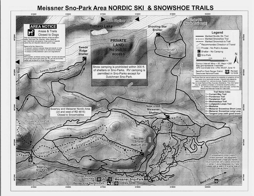
Meissner Sno-Park Area NORDIC SKI & SNOWSHOE TRAILS615000 616000 617000 618000 619000 620000
~
LegendMarked Nordic Ski TrailMarked Snowshoe TrailMarked Snowmobile Trail
/ Recommended Direction of Travel
r C Private - No Public Access
IIShelter - No Camping
sa Sno-Parko 025
g;
I
05Mile
Contour Interval: Minor = SO', Major = 250'Map grid represents 1 kilometerGPS Coordinate Grid: UTM, NAD27, Zone 10
BendlFort Rock Ranger District n RevisedDeschutes National Forest U 12/15/09
N
Ag~:I
The Forest Service cannot assure the reliability or suitability of thisinformation for a particular purpose. Original dala elements
were compiled from various sources. Spatial informationmay not meel National Map Accuracy Standards. This information
may be updated,corrected, or otherwise modified withoutnotification. For additional information about this data, contact the
Deschutes National Forest 541·383·5300.
~,Trail Name Index
1 = Currant Way Trail2 = Ponderosa Trail3 = Penstemon Trail4 = Wednesdays Trail5 = Lodgepole Loops Trail6 = Mistletoe I7 = Meissner Snowshoe Short Loop r8 = Meissner Snowshoe Long Loop9 = Tangent Loop (with good snow)
~:I
~:I
8~
g~
615000 816000 617000 618000 619000 620000
MEISSNER SNO-PARK NORDIC SKIING AND SNOWSHOEING
Virginia Meissner Sno-park was named inmemory of Virginia Meissner and hercontributions to Nordic skiing in CentralOregon. Sno-Park permits are requiredfrom November 1S to April 30. Dogs areNOT allowed.
Currant Way1.1 miles (easy)Heading west from the trailhead, the trailmoves over undulating terrain throughgrand fir and small stands of lodgepole andponderosa - makes a great loop of 1.9miles by returning on Tangent (moderate).
Gentian1.2 miles (difficult)Gentian is accessed off the north Tangenttrail at what is known as "S Corners" (theintersections of Tangent, Gentian,Wednesdays and Snowbush) and haswonderful views of South Sister andBroken Top. This trail moves side to sideand has some swooping downhill corners.
lodgepole Loops1.4 miles (easy)Beginning east of the trailhead, this is agreat figure 8 trail loop for beginners withflat to rolling terrain with gentle uphill anddownhill slopes.
Lupine0.3 miles (difficult)Provides alternate access to and fromMeissner Shelter. Not a groomed trail.
Manzanita0.9 miles (easy)Provides access to Meissner Shelter and isone of the most popular trails. It windsthrough open country with wonderfulmountain views.
Mistletoe0.4 miles (moderate)A fun downhill run from the Meissnershelter back to Tangent.
Paintbrush Loop1.4 miles (difficult)Provides access to the Shooting Starshelter. S. part of loop not groomed. N.part of loop periodically groomed.
Paintbrush/Columbine1.5 miles (moderate terrain, but rateddifficult due to distance from trailhead)Moderate length ski to some great viewsat the cinder pit. Accessed via Tangentand Wednesdays. Also known as "CinderPit" trail.
Pine Drops1.7 miles (moderate)This trail begins by the grooming garageoff Tangent and heads north throughrolling terrain, crosses Tangent again andthen northeast to intersect withSnowbush.
Ponderosa3.6 miles (easy to moderate)Whether classic or skating, you will lovethe challenging terrain of this trail as itmoves through stands of old growthponderosa and grand fir. S. part of loop iseasy, N. part of loop is moderate terrain.
Snowbush1.6 miles (moderate)This makes a great downhill run whenskied from west to east. Ski up toMeissner Shelter from the bottom. PineDrops connects here as well to complete aloop back to Tangent or to accessPonderosa and Wild Strawberry.
Tangent Loop5.5 miles (easy to moderate)Primary corridor for Meissner. Alsoprovides access to Swampy area. Greatmountain views are on the north side.
Wednesdays4 miles (moderate to difficult)The north part of Wednesdays is groomedand also known as the "Cinder Pit Trail"when connecting with Paintbrush andColumbine. The remaining part ofWednesdays is not a groomed trail.
Wild Strawberry1.6 miles (difficult)This is the most expert trail on theMeissner system. If you love rolling, twistytrails, this is for you.
Meissner Snowshoe Loops3.2 miles (easy to moderate)A 3 Y. mile loop trail, with a 1 % mile shortloop option. These trails are designed forsnowshoers only and marked with bluediamonds with a yellow snowshoer symbolin the center. When on groomed trails,please stay off the set ski tracks.
Nordeen Snowshoe Tie2.5 miles (moderate to difficult)Connects Meissner Sno-Park to Nordeenshelter, then on to the Snowshoe LongLoop on the Swampy Trail system.
Trail GroomingThe Meissner Nordic Community Ski Club grooms upto 40 kms of trail for both skating and classicaltechnique. Trails are groomed on Tuesday, Thursday,Saturday and Sunday from December 1- March 31.Check the Snow Phone or website for the latestgrooming report: 541.585.2289 ormeissnernordic.org Please beware that groomingequipment and personnel may be on these trailsduring these periods and other unscheduled times.
mmrmNordic Trails and shelters in this area are built andmaintained by volunteers from Meissner Nordic,Central Oregon Nordic Club and the Oregon NationalGuard in cooperation with the USDAForest Service.Your cooperation is essential to keep these facilitiesavailable for public use. Please use wood sparingly,pack out all trash, discourage vandalism and noovernight camping within 300 ft. of shelters.
Emergency 9-1-1Deschutes non-emergency 541-693-6911Deschutes National Forest Recreation Information &Lost and Found 541-383-4000
i§t'l;j I][4i:J tt1~[,Piti:te)i i;,.,i.ji[.111j, •a1. Match your abilities and experience with your
trip plans.2. Do not snowshoe or walk on a ski track.3. Keep to the right when meeting another skier.
When stopped, do not block the trail.4. Yield the right of way to the descending skier.5. If an accident occurs, everyone should render
necessary assistance. Witnesses shouldestablish their identities.
6. Respect the rights of all winter users. Do notinterfere with or harass others. People mayjudge all skiers or snowmobilers by oneindividual's actions.
7. Do not litter. If you pack it in, pack it out.8. Please respect areas closed to dogs. If you visit
areas open to dogs, follow canine courtesy.9. Shelter policy - Day Use only. No overnight
camping - overnight use exhausts firewoodrapidly.
10. Ski or snowshoe at your own risk!
This map produced and printed in cooperation with the Meissner Nordic Community Ski Club (Meissnernordic.org ) and the Deschutes National Forest.Nordic trails in this area are maintained by volunteers from Meissner Nordic, CONCand Deschutes National Forest. Trails groomed by Meissner Nordic. All are in
cooperation with Deschutes National Forest * Bend-Fort Rock Ranger District (http://www.fs.fed.us/r6/centraloregon)