draft final - california high-speed rail · california high-speed train project eir/eis draft final...
TRANSCRIPT

DRAFT FINALHistoric Architectural
Survey Report
Merced to Fresno Section Project EIR/EIS
February 2012
Project Environmental Impact Report /Environmental Impact Statement
Sacramento
Stockton
Modesto
Merced
San Francisco
Fresno
Kings/Tulare(Potential Station)
Gilroy
San Jose
Redwood City/Palo Alto (Potential Station)
Millbrae-SFO
Bakersfield
Palmdale
San Fernando/Burbank Ontario Airport
Norwalk Riverside/Corona
Murrieta
Escondido
San Diego
EastSan Gabriel
ValleyLos Angeles
Anaheim


CALIFORNIA HIGH-SPEED TRAIN PROJECT EIR/EIS
DRAFT FINAL TECHNICAL REPORT
Merced to Fresno Section Historic Architectural Survey Report
Prepared by:
California High-Speed Rail Authority and Federal Railroad Administration
February 2012


CALIFORNIA HIGH-SPEED TRAIN PROJECT EIR/EIS DRAFT FINAL HISTORIC ARCHITECTURAL SURVEY REPORT MERCED TO FRESNO SECTION
Page i
Table of Contents List of Abbreviated Terms ............................................................................................. iii 1.0 Introduction..................................................................................................... 1-1 2.0 Summary of Findings ....................................................................................... 2-1 3.0 Description of the Undertaking ....................................................................... 3-1
3.1 No Project Alternative ................................................................................ 3-1 3.2 High-Speed Train Alternatives ..................................................................... 3-1
3.2.1 UPRR/SR 99 Alternative .................................................................. 3-1 3.2.2 BNSF Alternative ............................................................................ 3-5 3.2.3 Hybrid Alternative (Preferred Alternative) ......................................... 3-7 3.2.4 Heavy Maintenance Facility Alternatives ........................................... 3-8
3.3 Project Construction .................................................................................. 3-8 4.0 Area of Potential Effects .................................................................................. 4-1
4.1 Description of the APE ............................................................................... 4-1 5.0 Summary of Identification Effort .................................................................... 5-1
5.1 Previously Identified Built Environment Resources ........................................ 5-1 5.2 Consulting Parties, Public Participation ........................................................ 5-7 5.3 Field and Research Methodology ................................................................. 5-8
6.0 Historic Context ............................................................................................... 6-1 6.1 Natural Setting .......................................................................................... 6-1 6.2 Historic Setting .......................................................................................... 6-1
6.2.1 San Joaquin Valley ......................................................................... 6-1 6.2.2 Merced County .............................................................................. 6-2 6.2.3 Madera County .............................................................................. 6-8 6.2.4 Fresno County .............................................................................. 6-12
7.0 Built Environment Resources Identified as Not Eligible for the NRHR or the CRHR ................................................................................................................ 7-1
8.0 Findings ........................................................................................................... 8-1 9.0 References ....................................................................................................... 9-1 10.0 Preparer Qualifications .................................................................................. 10-1
Appendices
A Maps: Project Location, Project Vicinity, and Area of Potential Effects for Built Environment Resources (bound separately)
B Correspondence C DPR 523 Forms D Streamlined Documentation E California Historical Resource Status Codes F Programmatic Agreement

CALIFORNIA HIGH-SPEED TRAIN PROJECT EIR/EIS DRAFT FINAL HISTORIC ARCHITECTURAL SURVEY REPORT MERCED TO FRESNO SECTION
Page ii
Tables
5-1 Previously Identified Built Environment Resources within the HST Project Area of Potential Effects ......................................................................................................... 5-2
6-1 Population Statistics, City of Atwater 1930-2000 ........................................................... 6-7 7-1 Built Environment Resources that do not appear Eligible for the NRHP or CRHR ............... 7-2
Figures
3-1 Merced to Fresno Section HST Alternatives .................................................................. 3-2 3-2a-b Ave 24 Wye and Chowchilla Design Options ............................................................. 3-4 6-1 Detail from Mapa de los Estados Unidos de Méjico, Disturnell, 1847 ............................... 6-3 6-2 Southern Pacific Railroad in California, Colton, 1876 ...................................................... 6-4 6-3 Detail, Merced Irrigation Map, showing locations of the cities of Atwater and Merced,
Hall, 1885 ............................................................................................................. 6-6 6-4 Map of Madera, Thompson 1891 ................................................................................ 6-11 6-5 Fresno County Irrigation sheet, Hall, 1885 ................................................................... 6-13 6-6 Detail, Fresno County, Thompson, 1891 ...................................................................... 6-14

CALIFORNIA HIGH-SPEED TRAIN PROJECT EIR/EIS DRAFT FINAL HISTORIC ARCHITECTURAL SURVEY REPORT MERCED TO FRESNO SECTION
Page iii
List of Abbreviated Terms
ACHP Advisory Council on Historic Preservation
APE Area of Potential Effects
APN Assessor Parcel Number
Authority California High-Speed Rail Authority
BNSF Burlington Northern Santa Fe Railway
Caltrans California Department of Transportation
CASHPO California State Historic Preservation Officer
CCIC Central California Information Center
CEQA California Environmental Quality Act
CFR Code of Federal Regulations
CHRIS California Historical Resources Information System
CRHR California Register of Historical Resources
Delta Sacramento-San Joaquin Delta
DPR Department of Parks and Recreation
EIR Environmental Impact Report
EIS FOE
Environmental Impact Statement Findings of Effect
FRA Federal Railroad Administration
HABS Historic American Building Survey
HAER Historic American Engineering Record
HASR Historic Architectural Survey Report
HLRC Historical Landmarks and Records Commission
HMF heavy maintenance facility
HPSR Historic Property Survey Report
HST high-speed train
LOD limits of disturbance
mph MOA
miles per hour Memorandum of Agreement
NEPA National Environmental Policy Act of 1969
NHPA National Historic Preservation Act
NRHP National Register of Historic Places
OHP Office of Historic Preservation

CALIFORNIA HIGH-SPEED TRAIN PROJECT EIR/EIS DRAFT FINAL HISTORIC ARCHITECTURAL SURVEY REPORT MERCED TO FRESNO SECTION
Page iv
PA Programmatic Agreement
PG&E Pacific Gas and Electric
QI Qualified Investigator
SR State Route
SSJVIC Southern San Joaquin Valley Information Center
UPRR Union Pacific Railroad

CALIFORNIA HIGH-SPEED TRAIN PROJECT EIR/EIS DRAFT FINAL HISTORIC ARCHITECTURAL SURVEY REPORT MERCED TO FRESNO SECTION
Page 1-1
1.0 Introduction This Historic Architectural Survey Report (HASR) has been prepared as part of the California High-Speed Train (HST) project, Merced to Fresno Section. This study has been prepared to assist the project proponent, the California High-Speed Rail Authority (Authority), and the lead federal agency, the Federal Railroad Administration (FRA), to comply with Section 106 of the National Historic Preservation Act (NHPA), and its implementing regulations issued by the Advisory Council on Historic Preservation (ACHP), as these pertain to federally funded undertakings and their impacts on historic properties. This study also assists the Authority and FRA to comply with the National Environmental Policy Act (NEPA), California Environmental Quality Act (CEQA) and the NEPA and CEQA Guidelines, as they pertain to historical resources, for this project.
This study follows the procedures set forth in the Programmatic Agreement (PA). The PA provides an overall framework for the Section 106 process to be conducted across all nine separate and independent projects that are part of the California HST Project, of which the Merced to Fresno Section is one project. The PA also provides guidelines for the development of the Area of Potential Effects (APE); the identification, documentation, and evaluation of historic properties; and the assessment of adverse effects.
The purpose of this HASR document is (1) to present the APE for the built environment resources for the project; (2) to identify properties that are not eligible for listing in the National Register of Historic Places (NRHP) or California Register of Historical Resources (CRHR); (3) to present historic status and the conclusions of evaluations of potential significance for properties within the APE that are not exempt under the PA and require evaluation to fulfill Section 106, NEPA, and CEQA obligations; and (4) to present findings that are not reported in the Historic Property Survey Report (HPSR). The HPSR is a separate document prepared to document known historic properties, those listed or eligible for listing in the NRHP, historical resources for the purpose of CEQA, and properties that are ineligible for the NRHP, but will be acquired, destroyed, demolished, or substantially altered as the result of the undertaking.
The HASR will be submitted to the California State Historic Preservation Officer (CASHPO) for review. The CASHPO will review and evaluate the adequacy of the accompanying APE, as well as the identification and evaluation findings of the study. Upon CASHPO concurrence with the eligibility determinations, future documents will present the Findings of Effect (FOE) analysis and propose appropriate mitigation for any adverse effects to historic properties that are identified in a Findings of Effect report. The conclusions of both the HPSR and HASR will be used as the basis for the Environmental Impact Report/Environmental Impact Study (EIR/EIS) prepared for the Merced to Fresno Section of the HST System.


CALIFORNIA HIGH-SPEED TRAIN PROJECT EIR/EIS DRAFT FINAL HISTORIC ARCHITECTURAL SURVEY REPORT MERCED TO FRESNO SECTION
Page 2-1
2.0 Summary of Findings This summary outlines the conclusions of the intensive inventory and evaluation of non-eligible built environment resources within the APE for the Merced to Fresno Section of the California HST Project, in accordance with the procedures set forth in the PA. The project location, project vicinity, and APE are shown on index sheets and associated map sheets in Appendix A of this HASR. The APE maps showing built environment resources include the assessor’s parcel numbers (APNs) that serve as the map reference numbers for built environment resources inventoried and evaluated by this study. Evaluations of all built environment resources are presented on Department of Parks and Recreation (DPR) 523 forms and other recordation forms prepared for previous studies. Many built environment resources within the APE were more than 50 years old, but were substantially altered, and as such were subject to “streamlined documentation” as set forth in Attachment C, Section C of the PA. The DPR 523 forms (Appendix C) and streamlined documentation (Appendix D) are organized north-to-south in the project area by county, and then in ascending numerical order by APN.
The architectural APE for this project contains a survey population of 551 built environment resources (buildings, structures, sites, objects, districts, landscapes). Of that survey population, 151 are inventoried in the HPSR and consist of 18 built environment resources that are NRHP listed or eligible for listing or were historical resources for the purposes of CEQA; and 133 built environment resources that were ineligible, but would be acquired, destroyed, demolished, or substantially altered as the result of the undertaking. All 151 properties represented in the HPSR were documented on DPR 523 forms. The remaining 400 built environment resources are inventoried and evaluated in this HASR and consist of 177 ineligible properties that were documented on DPR 523 forms (Appendix C) and 223 ineligible properties that were substantially altered and documented on streamlined documentation (Appendix D). The evaluations concluded that none of these properties appear to meet the eligibility criteria for the NRHP or the CRHR, and none of the properties were resources for the purposes of CEQA.


CALIFORNIA HIGH-SPEED TRAIN PROJECT EIR/EIS DRAFT FINAL HISTORIC ARCHITECTURAL SURVEY REPORT MERCED TO FRESNO SECTION
Page 3-1
3.0 Description of the Undertaking The purpose of the Merced to Fresno Section of the HST Project is to implement the California HST System between Merced and Fresno, providing the public with electric-powered high-speed rail service that provides predictable and consistent travel times between major urban centers and connectivity to airports, mass transit systems, and the highway network in the south San Joaquin Valley, and to connect the northern and southern portions of the HST System. The approximately 65-mile-long corridor between Merced and Fresno is an essential part of the statewide HST System. The Merced to Fresno Section is the location where the HST would intersect and connect with the Bay Area and Sacramento branches of the HST System; it would provide a potential location for the heavy maintenance facility (HMF) where the HSTs would be assembled and maintained, as well as a test track for the trains; it would also provide Merced and Fresno access to a new transportation mode and would contribute to increased mobility throughout California.
3.1 No Project Alternative
The No Project Alternative refers to the projected growth planned for the region through the 2035 time horizon without the HST Project and serves as a basis of comparison for environmental analysis of the HST build alternatives. The No Project Alternative includes planned improvements to the highway, aviation, conventional passenger rail, and freight rail systems in the Merced to Fresno project area. There are many environmental impacts that would result under the No Project Alternative.
3.2 High-Speed Train Alternatives
As shown in Figure 3-1, there are three HST alignment alternatives proposed for the Merced to Fresno Section of the HST System: the UPRR/SR 99 Alternative, which would primarily parallel the UPRR railway; the BNSF Alternative, which would parallel the BNSF railway for a portion of the distance between Merced and Fresno; and the Hybrid Alternative, which combines features of the UPRR/SR 99 and BNSF alternatives. In addition, there is an HST station proposed for both the City of Merced and the City of Fresno, there is a wye connection (see text box on page 3-3) west to the Bay Area, and there are five potential sites for a proposed HMF.
The Authority has identified the Hybrid Alternative as the preferred alternative for the north-south alignment between Merced and Fresno. The Hybrid Alternative would connect to San Jose to the west along one of three wye design options. The San Jose to Merced Section Project EIR/EIS will fully evaluate the east-west alignment alternatives and wye configurations, including the Ave 24 Wye, the Ave 21 Wye, and another wye design option, the SR 152 Wye. This report contains analysis of the north-south alignment and portions of the Ave 24 Wye and Ave 21 Wye. A decision regarding the preferred east-west alignment, including the preferred wye design option, will take place after circulation of the San Jose to Merced Section Project EIR/EIS; that decision will finalize the alignment and profile of the Hybrid Alternative. In addition, the Authority has identified the Mariposa Street Station Alternative as the preferred alternative for an HST station in Downtown Fresno.
3.2.1 UPRR/SR 99 Alternative
This section describes the UPRR/SR 99 Alternative, including the Chowchilla design options, wyes, and HST stations.
3.2.1.1 North-South Alignment
The north-south alignment of the UPRR/SR 99 Alternative would begin at the HST station in Downtown Merced, located on the west side of the UPRR right-of-way. South of the station and leaving Downtown Merced, the alternative would be at-grade and cross under SR 99. Approaching the City of Chowchilla, the UPRR/SR 99 Alternative has two design options: the East Chowchilla design option, which would pass Chowchilla on the east side of town, and the West Chowchilla design option, which would pass Chowchilla

CALIFORNIA HIGH-SPEED TRAIN PROJECT EIR/EIS DRAFT FINAL HISTORIC ARCHITECTURAL SURVEY REPORT MERCED TO FRESNO SECTION
Page 3-2
Figure 2-1 Merced to Fresno Section
HST Alternatives
Figure 3-1 Merced to Fresno Section
HST Alternatives

CALIFORNIA HIGH-SPEED TRAIN PROJECT EIR/EIS DRAFT FINAL HISTORIC ARCHITECTURAL SURVEY REPORT MERCED TO FRESNO SECTION
Page 3-3
3 to 4 miles west of the city before turning back to rejoin the UPRR/SR 99 transportation corridor. These design options would take the following routes:
East Chowchilla design option: This design option would transition from the west side of the UPRR/SR 99 corridor to an elevated structure as it crosses the UPRR railway and N. Chowchilla Boulevard just north of Avenue 27, continuing on an elevated structure away from the UPRR corridor along the west side of and parallel to SR 99 to cross Berenda Slough. Toward the south side of Chowchilla, this design option would cross over SR 99 north of the SR 99/SR 152 interchange near Avenue 23½ south of Chowchilla. Continuing south on the east side of SR 99 and the UPRR corridor, this design option would remain elevated for 7.1 miles through the communities of Fairmead and Berenda until reaching the Dry Creek Crossing. The East Chowchilla design option connects to the HST sections to the west via either the Ave 24 or Ave 21 wyes (described below).
West Chowchilla design option: This design option would travel due south from Sandy Mush Road north of Chowchilla, following the west side of Road 11¾. The alignment would turn southeast toward the UPRR/SR 99 corridor south of Chowchilla. The West Chowchilla design option would cross over the UPRR and SR 99 east of the Fairmead city limits to again parallel the UPRR/SR 99 corridor. The West Chowchilla design option would result in a net decrease of approximately 13 miles of track for the HST System compared to the East Chowchilla design option and would remain outside the limits of the City of Chowchilla. The West Chowchilla design option connects to the HST sections to the west via the Ave 24 Wye, but not the Ave 21 Wye.
The UPRR/SR 99 Alternative would continue toward Madera along the east side of the UPRR south of Dry Creek and remain on an elevated profile for 8.9 miles through Madera. After crossing over Cottonwood Creek and Avenue 12, the HST alignment would transition to an at-grade profile and continue to be at-grade until north of the San Joaquin River. After the San Joaquin River crossing, the HST alignment would require realignment (a mostly westward shift) of Golden State Boulevard and of a portion of SR 99 to create right-of-way adjacent to the UPRR railroad that would not preclude future expansion of these roadways. After crossing the San Joaquin River, the alternative would rise over the UPRR railway on an elevated guideway, supported by straddle bents, before crossing over the existing Herndon Avenue and again descending into an at-grade profile and continuing west of and parallel to the UPRR right-of-way. After elevating to cross the UPRR railway on the southern bank of the San Joaquin River, south of Herndon Avenue, the alternative would transition from an elevated to an at-grade profile. Traveling south from Golden State Boulevard at-grade, the alternative would cross under the reconstructed Ashlan Avenue and Clinton Avenue overhead structures. Advancing south from Clinton Avenue between Clinton Avenue and Belmont Avenue, the HST guideway would run at-grade adjacent to the western boundary of the UPRR right-of-way and then enter the HST station in Downtown Fresno. The HST guideway would descend in a retained-cut to pass under the San Joaquin Valley Railroad spur line and SR 180, transition back to at-grade before Stanislaus Street, and continue to be at-grade into the station. As part of a station design option, Tulare Street would become either an overpass or undercrossing at the station.
3.2.1.2 Wye Design Options
The following text describes the wye connection from the San Jose to Merced Section to the Merced to Fresno Section. There are two variations of the Ave 24 Wye for the UPRR/SR 99 Alternative because of the West Chowchilla design option. The
What is a “Wye”? The word “wye” refers to the “Y”-like formation that is created where train tracks branch off the mainline to continue in different directions. The transition to a wye requires splitting two tracks into four tracks that cross over one another before the wye “legs” can diverge in opposite directions to allow bidirectional travel. For the Merced to Fresno Section of the HST System, the two tracks traveling east-west from the San Jose to Merced Section must become four tracks—a set of two tracks branching to the north and a set of two tracks branching to the south.

CALIFORNIA HIGH-SPEED TRAIN PROJECT EIR/EIS DRAFT FINAL HISTORIC ARCHITECTURAL SURVEY REPORT MERCED TO FRESNO SECTION
Page 3-4
Ave 21 Wye does not connect to the West Chowchilla design option and therefore does not have a variation.
Ave 24 Wye
The Ave 24 Wye design option would travel along the south side of eastbound Avenue 24 toward the UPRR/SR 99 Alternative and would begin diverging onto two sets of tracks west of Road 11 and west of the City of Chowchilla. Under the East Chowchilla design option, the northbound set of tracks would travel northeast across Road 12, joining the UPRR/SR 99 north-south alignment on the west side of the UPRR right-of-way just north of Sandy Mush Road. Under the West Chowchilla design option, the northbound set of tracks would travel northeast across Road 12 and would join the UPRR/SR 99 north-south alignment just south of Avenue 26. The southbound HST guideway would continue east along Avenue 24, turning south near SR 233 southeast of Chowchilla, crossing SR 99 and the UPRR railway to connect to the UPRR/SR 99 Alternative north-south alignment on the east side of the UPRR near Avenue 21½. Under the West Chowchilla design option, the southbound tracks would turn south near Road 16 south of Chowchilla, crossing SR 99 and the UPRR to connect to the UPRR/SR 99 north-south alignment on the east side of the UPRR adjacent to the city limits of Fairmead.
Figure 3-2a shows the wye alignment for the East Chowchilla design option and Figure 3-2b shows the alignment for the West Chowchilla design option. Together, the figures illustrate the difference in the wye triangle formation for each design option connection. The north-south alignment of the West Chowchilla design option between Merced and Fresno diverges along Avenue 24 onto Road 12, on the north branch of the wye, allowing the HST alternative to avoid traveling through Chowchilla and to avoid constraining the city within the wye triangle.
Ave 21 Wye
The Ave 21 Wye would travel along the north side of Avenue 21. Just west of Road 16, the HST tracks would diverge north and south to connect to the UPRR/SR 99 Alternative, with the north leg of the wye joining the north-south alignment at Avenue 23½ and the south leg at Avenue 19½.
3.2.1.3 HST Stations
The Downtown Merced and Downtown Fresno station areas would each occupy several blocks, to include station plazas, drop-offs, a multimodal transit center, and parking structures. The areas would include the station platform and associated building and access structure, as well as lengths of platform tracks to accommodate local and express service at the stations. As currently proposed, both the Downtown Merced and Downtown Fresno stations would be at-grade, including all trackway and platforms, passenger services and concessions, and back-of-house functions.
Downtown Merced Station
The Downtown Merced Station would be between Martin Luther King Jr. Way to the northwest and G Street to the southeast. The station would be accessible from both sides of the UPRR, but the primary
Figure 3-2a and b Ave 24 Wye and Chowchilla Design
Options

CALIFORNIA HIGH-SPEED TRAIN PROJECT EIR/EIS DRAFT FINAL HISTORIC ARCHITECTURAL SURVEY REPORT MERCED TO FRESNO SECTION
Page 3-5
station house would front 16th Street. The major access points from SR 99 include V Street, R Street, Martin Luther King Jr. Way, and G Street. Primary access to the parking facility would be from West 15th Street and West 14th Street, just one block east of SR 99. The closest access to the parking facility from the SR 99 freeway would be R Street, which has a full interchange with the freeway. The site proposal includes a parking structure that would have the potential for up to 6 levels with a capacity of approximately 2,250 cars and an approximate height of 50 feet.
Downtown Fresno Station Alternatives
There are two station alternatives under consideration in Fresno: the Mariposa Street Station Alternative and the Kern Street Station Alternative.
Mariposa Street Station Alternative (Preferred Alternative) The Mariposa Street Station Alternative is located in Downtown Fresno, less than 0.5-mile east of SR 99. The station would be centered on Mariposa Street and bordered by Fresno Street on the north, Tulare Street on the south, H Street on the east, and G Street on the west. The station building would be approximately 75,000 square feet, with a maximum height of approximately 60 feet. The two-level station would be at-grade, with passenger access provided both east and west of the HST guideway and the UPRR tracks, which would run parallel with one another adjacent to the station. Entrances would be located at both G and H Streets. The eastern entrance would be at the intersection of H Street and Mariposa Street, with platform access provided via the pedestrian overcrossing. The main western entrance would be located at G Street and Mariposa Street.
The majority of station facilities would be located east of the UPRR tracks. The station and associated facilities would occupy approximately 18.5 acres, including 13 acres dedicated to the station, bus transit center, surface parking lots, and kiss-and-ride accommodations. A new intermodal facility would be included in the station footprint on the parcel bordered by Fresno Street to the north, Mariposa Street to the south, Broadway Street to the east, and H Street to the west. The site proposal includes the potential for up to three parking structures occupying a total of 5.5 acres. Two of the three potential parking structures would each sit on 2 acres, and each would have a capacity of approximately 1,500 cars. The third parking structure would have a slightly smaller footprint (1.5 acres), with five levels and a capacity of approximately 1,100 cars. Surface parking lots would provide approximately 300 additional parking spaces.
Kern Street Station Alternative The Kern Street Station Alternative for the HST station would also be in Downtown Fresno and would be centered on Kern Street between Tulare Street and Inyo Street. This station would include the same components and acreage as the Mariposa Street Station Alternative, but the station would not encroach on the historic Southern Pacific Railroad depot just north of Tulare Street and would not require relocation of existing Greyhound facilities. Two of the three potential parking structures would each sit on 2 acres, and each would have a capacity of approximately 1,500 cars. The third structure would have a slightly smaller footprint (1.5 acres) and a capacity of approximately 1,100 cars. Like the Mariposa Street Station Alternative, the majority of station facilities under the Kern Street Station Alternative would be east of the HST tracks.
3.2.2 BNSF Alternative
This section describes the BNSF Alternative, including the Le Grand design options and wyes. It does not include a discussion of the HST stations, because the station descriptions are identical for each of the three HST alignment alternatives.
3.2.2.1 North-South Alignment
The north-south alignment of the BNSF Alternative would begin at the proposed Downtown Merced Station. This alternative would remain at-grade through Merced and would cross under SR 99 at the south end of the city. Just south of the interchange at SR 99 and E Childs Avenue, the BNSF Alternative

CALIFORNIA HIGH-SPEED TRAIN PROJECT EIR/EIS DRAFT FINAL HISTORIC ARCHITECTURAL SURVEY REPORT MERCED TO FRESNO SECTION
Page 3-6
would cross over SR 99 and UPRR as it begins to curve to the east, crossing over the E Mission Avenue interchange. It would then travel east to the vicinity of Le Grand, where it would turn south and travel adjacent to the BNSF tracks.
To minimize impacts on the natural environment and the community of Le Grand, the project design includes four design options:
Mission Ave design option: This design option would turn east to travel along the north side of Mission Avenue at Le Grand and then would elevate through Le Grand adjacent to and along the west side of the BNSF corridor.
Mission Ave East of Le Grand design option: This design option would vary from the Mission Ave design option by traveling approximately 1 mile farther east before turning southeast to cross Santa Fe Avenue and the BNSF tracks south of Mission Avenue. The HST alignment would parallel the BNSF for 0.5 mile to the east, avoiding the urban limits of Le Grand. This design option would cross Santa Fe Avenue and the BNSF railroad again approximately 0.5 mile north of Marguerite Road and would continue adjacent to the west side of the BNSF corridor.
Mariposa Way design option: This design option would travel 1 mile farther than the Mission Ave design option before crossing SR 99 near Vassar Road and turning east toward Le Grand along the south side of Mariposa Way. East of Simonson Road, the HST alignment would turn to the southeast. Just prior to Savana Road in Le Grand, the HST alignment would transition from at-grade to elevated to pass through Le Grand on a 1.7-mile-long guideway adjacent to and along the west side of the BNSF corridor.
Mariposa Way East of Le Grand design option: This design option would vary from the Mariposa Way design option by traveling approximately 1 mile farther east before turning southeast to cross Santa Fe Avenue and the BNSF tracks less than 0.5 mile south of Mariposa Way. The HST alignment would parallel the BNSF to the east of the railway for 0.5 mile, avoiding the urban limits of Le Grand. This design option would cross Santa Fe Avenue and the BNSF again approximately 0.5 mile north of Marguerite Road and would continue adjacent to the west side of the BNSF corridor.
Continuing southeast along the west side of the BNSF corridor, the BNSF Alternative would begin to curve just before Plainsburg Road through a predominantly rural and agricultural area. One mile south of Le Grand, the HST alignment would cross Deadman and Dutchman creeks. The alignment would deviate from the BNSF corridor just southeast of S White Rock Road, where it would remain at-grade for another 7 miles, except at the bridge crossings, and would continue on the west side of the BNSF corridor through the community of Sharon. The HST alignment would continue at-grade through the community of Kismet until crossing at Dry Creek. The BNSF Alternative would then continue at-grade through agricultural areas along the west side of the BNSF corridor through the community of Madera Acres north of the City of Madera; in the vicinity of Madera Acres, the HST Project would provide a grade separation of Road 26 and Road 28, which would cross over both the existing BNSF tracks and the new HST guideway. South of Avenue 15 east of Madera, the alignment would transition toward the UPRR corridor, following the east side of the UPRR corridor near Avenue 9 south of Madera, then continuing along nearly the same route as the UPRR/SR 99 Alternative over the San Joaquin River to enter the community of Herndon. After crossing the San Joaquin River, the alignment would be the same as for the UPRR/SR 99 Alternative
3.2.2.2 Wye Design Options
The Ave 24 Wye and the Ave 21 Wye would be the same as described for the UPRR/SR 99 Alternative (East Chowchilla design option), except as noted below.
Ave 24 Wye
As with the UPRR/SR 99 Alternative, the Ave 24 Wye would follow along the south side of Avenue 24 and would begin diverging into two sets of tracks (i.e., four tracks) beginning west of Road 17. Two tracks

CALIFORNIA HIGH-SPEED TRAIN PROJECT EIR/EIS DRAFT FINAL HISTORIC ARCHITECTURAL SURVEY REPORT MERCED TO FRESNO SECTION
Page 3-7
would travel north near Road 20½, where they would join the north-south alignment of the BNSF Alternative on the west side of the BNSF corridor near Avenue 26½. The two southbound tracks would join the BNSF Alternative on the west side of the BNSF corridor south of Avenue 21.
Ave 21 Wye
As with the UPRR/SR 99 Alternative, the Ave 21 Wye would travel along the north side of Avenue 21. Two tracks would diverge, turning north and south to connect to the north-south alignment of the BNSF Alternative just west of Road 21. The north leg of the wye would join the north-south alignment just south of Avenue 24, and the south leg would join the north-south alignment just east of Frontage Road/Road 26 north of the community of Madera Acres.
3.2.3 Hybrid Alternative (Preferred Alternative)
This section describes the Hybrid Alternative, which generally follows the alignment of the UPRR/SR 99 Alternative in the north and the BNSF Alternative in the south. It does not include a discussion of the HST stations because the station descriptions are identical for each of the three HST alternatives.
3.2.3.1 North-South Alignment
From north to south, generally, the Hybrid Alternative would follow the UPRR/SR 99 alignment with either the West Chowchilla design option with the Ave 24 Wye or the East Chowchilla design option with the Ave 21 Wye. Approaching the Chowchilla city limits, the Hybrid Alternative would follow one of two options:
In conjunction with the Ave 24 Wye, the HST alignment would veer due south from Sandy Mush Road along a curve and would continue at-grade for 4 miles parallel to and on the west side of Road 11¾. The Hybrid Alternative would then curve to a corridor on the south side of Avenue 24 and would travel parallel for the next 4.3 miles. Along this curve, the southbound HST track would become an elevated structure for approximately 9,000 feet to cross over the Ave 24 Wye connection tracks and Ash Slough, while the northbound HST track would remain at-grade. Continuing east on the south side of Avenue 24, the HST alignment would become identical to the Ave 24 Wye connection for the BNSF Alternative and would follow the alignment of the BNSF Alternative until Madera.
In conjunction with the Ave 21 Wye connection, the HST alignment would transition from the west side of UPRR and SR 99 to an elevated structure as it crosses the UPRR and N. Chowchilla Boulevard just north of Avenue 27, continuing on an elevated structure along the west side of and parallel to SR 99 away from the UPRR corridor while it crosses Berenda Slough. Toward the south side of Chowchilla, the alignment (with the Ave 21 Wye) would cross over SR 99 north of the SR 99/SR 152 interchange near Avenue 23½ south of Chowchilla. It would continue to follow along the east side of SR 99 until reaching Avenue 21, where it would curve east and run parallel to Avenue 21, briefly. The alignment would then follow a path similar to the Ave 21 Wye connection for the BNSF Alternative, but with a tighter 220 miles per hour (mph) curve. The alternative would then follow the BNSF Alternative alignment until Madera.
Through Madera and until reaching the San Joaquin River, the Hybrid Alternative is the same as the BNSF Alternative. Once crossing the San Joaquin River, the alignment of the Hybrid Alternative becomes the same as for the UPRR/SR 99 Alternative, including the westward realignments of Golden State Boulevard and SR 99.
3.2.3.2 Wye Design Options
The wye connections for the Hybrid Alternative follow Avenue 24 and Avenue 21, similar to those of the UPRR/SR 99 and BNSF alternatives.

CALIFORNIA HIGH-SPEED TRAIN PROJECT EIR/EIS DRAFT FINAL HISTORIC ARCHITECTURAL SURVEY REPORT MERCED TO FRESNO SECTION
Page 3-8
Ave 24 Wye
The Ave 24 Wye is the same as the combination of the UPRR/SR 99 Alternative with the West Chowchilla design option, and the Ave 24 Wye for the BNSF Alternative.
Ave 21 Wye
The Ave 21 Wye is similar to the combination of the UPRR/SR 99 Alternative with the Ave 21 Wye on the northbound leg and the BNSF Alternative with the Ave 21 Wye on the southbound leg. However, the south leg under the Hybrid Alternative would follow a tighter, 220 mph curve than the BNSF Alternative, which follows a 250 mph curve.
3.2.4 Heavy Maintenance Facility Alternatives
The Authority is studying five HMF sites (see Figure 3-1) within the Merced to Fresno Section, one of which may be selected. (The sponsor of the Harris-DeJager site withdrew its proposal from the Authority’s consideration of potential HMF sites [Kopshever 2011]. However, to remain consistent with previous analysis and provide a basis of comparison among the HMFs, evaluation of the site continues in this document.)
Castle Commerce Center HMF site – A 370-acre site located 6 miles northwest of Merced, at the former Castle Air Force Base in northern unincorporated Merced County. It is adjacent to and on the east side of the BNSF mainline, 1.75 miles south of the UPRR mainline, off of Santa Fe Drive and Shuttle Road, 2.75 miles from the existing SR 99 interchange. The Castle Commerce Center HMF would be accessible by all HST alternatives.
Harris-DeJager HMF site (withdrawn from consideration) – A 401-acre site located north of Chowchilla adjacent to and on the west side of the UPRR corridor, along S. Vista Road and near the SR 99 interchange under construction. The Harris-DeJager HMF would be accessible by the UPRR/SR 99 and Hybrid alternatives if coming from the Ave 21 Wye and the UPRR/SR 99 Alternative with the East Chowchilla design option and the Ave 24 Wye.
Fagundes HMF site – A 231-acre site, located 3 miles southwest of Chowchilla on the north side of SR 152, between Road 11 and Road 12. This HMF would be accessible by all HST alternatives with the Ave 24 Wye.
Gordon-Shaw HMF site – A 364-acre site adjacent to and on the east side of the UPRR corridor, extending from north of Berenda Boulevard to Avenue 19. The Gordon-Shaw HMF would be accessible from the UPRR/SR 99 Alternative.
Kojima Development HMF site – A 392-acre site on the west side of the BNSF corridor east of Chowchilla, located along Santa Fe Drive and Robertson Boulevard (Avenue 26). The Kojima Development HMF would be accessible by the BNSF Alternative with the Ave 21 Wye.
3.3 Project Construction
At-grade track sections would be built using conventional railroad construction techniques. A typical sequence includes clearing, grubbing, contouring, and compacting of the rail bed; application of ballast; laying track; and installing electrical and communications systems. The precast segmental construction method is proposed for elevated track sections. In this construction method, large concrete bridge segments would be mass-produced at an onsite temporary casting yard. Precast segments would then be transported atop the already completed portions of the elevated track and installed using a special gantry crane positioned on the viaduct. Although the precast segmental method is the favored technique for viaduct construction, other methods may be used, including cast-in-place, box girder, or precast span-by-span techniques. Construction is currently planned to commence in 2012 and conclude in 2017.

CALIFORNIA HIGH-SPEED TRAIN PROJECT EIR/EIS DRAFT FINAL HISTORIC ARCHITECTURAL SURVEY REPORT MERCED TO FRESNO SECTION
Page 4-1
4.0 Area of Potential Effects Section 106 requires that an APE be defined for the project. An APE is defined in 36 Code of Federal Regulations (CFR) Section 800.16(d) as the geographic area or areas within which an undertaking may directly or indirectly cause alterations in the character or use of historic properties, if any such properties exist. The APE is influenced by the scale and nature of an undertaking; it may be different for different kinds of effects caused by the undertaking and different types of resources. The APE for this undertaking was developed in accordance with both 36 CFR 800.16(d) and the guidelines set forth in Attachment B of the PA (see Appendix F) drafted by the FRA, ACHP, and the CASHPO.
The HASR presents the APE for built environment resources for the project (see Appendix A). It should be noted that while the Merced to Fresno Section project area and the APE extend to Ventura Street in Downtown Fresno, this report (as well as the HPSR and Archaeological Survey Report [ASR]), only includes analysis to E. Amador Street. The technical reports (HPSR, HASR, and ASR) prepared for the next HST section to the south, Fresno to Bakersfield, include analysis of the resources south of E. Amador Street to Ventura Street, including the Fresno Station (Authority and FRA 2012c, d). This separation avoids redundancy in the technical analysis needed for formal Section 106 compliance.
The APE will be submitted to the California State Office of Historic Preservation (OHP) for CASHPO concurrence and was used to identify the built environment resources considered in this report. See the following sections for more detailed descriptions of the built environment APE as well as Section 3.0 for a detailed discussion of the alternatives.
4.1 Description of the APE
The initial APE for the Merced to Fresno Section was approved by the CASHPO on August 16, 2010 (M.W. Donaldson to J. Ketelsen or R. Rodland, August 16, 2010). Since then, the APE has been refined to reflect changes in the alignment and guidelines set forth in Attachment B of the PA. The refined APE, included in Appendix A for concurrence by the CASHPO, was used to determine the survey population for this HASR. The APE may be revised according to future refinements to the proposed rail alignment alternatives and as engineering revisions become available. All APE refinements or changes will be subject to consultation with CASHPO. The current APE is shown in Appendix A of this HASR.
The built environment APE for the Merced to Fresno Section includes all legal parcels intersected by the proposed limits of disturbance (LOD), or the footprint of actual facilities proposed for construction (e.g., tracks, grade separations, stations, switchyards, and maintenance facilities), and construction staging areas, and also includes properties that could be directly affected by the undertaking. If built environment resources existed on a large rural parcel within 150 feet of the proposed HST at-grade right-of-way, or if it was determined that the resources on that parcel were otherwise potentially affected by the project, the entire parcel was included in the APE. If built environment resources on a large rural parcel were more than 150 feet away from the proposed HST at-grade right-of-way, and were otherwise not potentially affected by the project, the APE boundary was set at the limits of the proposed right-of-way. In these cases, resources outside the APE on that parcel did not require further survey.
The built environment APE also includes properties adjacent to those intersected by the proposed HST project if the built environment resources on those parcels may be indirectly affected by the undertaking as the result of visual or audible changes that may cause changes in traffic or land use patterns. The built environment APE is further defined according to the following parameters set forth in Attachment B of the PA (see Appendix F):
The APE for historic architectural properties includes all properties that contain buildings, structures or objects more than 50 years of age at the time of the survey is completed by the Qualified Investigators (QIs), as follows:
Properties within the proposed project right-of-way;

CALIFORNIA HIGH-SPEED TRAIN PROJECT EIR/EIS DRAFT FINAL HISTORIC ARCHITECTURAL SURVEY REPORT MERCED TO FRESNO SECTION
Page 4-2
Properties where historic materials or associated landscape features would be demolished, moved, or altered by construction;
Properties near the undertaking where railroad materials, features, and activities HAVE NOT been part of their historic setting and where the introduction of visual or audible elements may affect the use or characteristics of those properties that would be the basis for their eligibility for listing in the National Register; and
Properties near the undertaking that were either used by a railroad, served by a railroad, or where railroad materials, features, and activities HAVE long been part of their historic setting, but only in such cases where the undertaking would result in a substantial change from the historic use, access, or noise and vibration levels that were present 50 years ago, or during the period of significance of a property, if different.
For the HST project, a key phrase in the APE definition in the Section 106 regulations contained within 36 CFR 800.16(d) is ‘may cause alterations in the character or use of historic properties’ because many of the undertakings involve the construction of high-speed rail alongside existing railroads. In such cases, potential historic properties near the proposed undertaking historically had railroad features, materials, and activities within their setting that contributed to their character, or may even have been used by or served by the railroad. For example:
The character and use of a historic railroad passenger or freight depot or railroad bridge would not change unless it would be put out of service, destroyed, altered, or moved for the undertaking;
The character and use of an industrial building next to existing railroad tracks would not change unless freight railroad service was an important association and the spur lines or loading areas would be removed by the undertaking;
The character and use of buildings would not change if they would be separated from the undertaking by an existing railroad; however,
The character of a non-railroad or non-industrial building would likely change if the building is visually sensitive and the proposed undertaking introduces an elevated grade separation or other large building or structure;
The use of a non-railroad or non-industrial building would likely change if the building is sensitive to noise, like a school, museum, or library, and the frequency of noise or vibration events from passing trains is increased over historic-era railroad events.
However, some sections of an undertaking may be introducing rail service where none existed during the historic era, for example, along a highway or through agricultural fields. For such sections, the undertaking is more likely to change the character or use of a historic property, and the APE would take into account changes to its setting and the introduction of visible or audible elements that are out of character with the property. Other effects to be considered when delineating the APE may include, but are not limited to, physical damage or destruction of all or part of a property; physical alterations; moving or realigning a historic property; isolating a property from its setting; visual, audible, or atmospheric intrusions; shadow effects; damage from vibrations; and change in access or use (Authority and FRA 2011b).

CALIFORNIA HIGH-SPEED TRAIN PROJECT EIR/EIS DRAFT FINAL HISTORIC ARCHITECTURAL SURVEY REPORT MERCED TO FRESNO SECTION
Page 5-1
5.0 Summary of Identification Effort This chapter describes the inventory and field methods employed, the methods to characterize historic context and previously recorded historic properties, and involvement of the public. The methods outlined here represent the implementation of the Merced to Fresno Architectural Survey and Evaluation Plan (Authority and FRA 2009a), which were submitted to and approved by the Project Management Team and the Authority. Relevant aspects of the PA were incorporated into both inventory and evaluation plans and were also implemented during the course of the identification effort.
5.1 Previously Identified Built Environment Resources
Architectural historians meeting the professional qualifications of the Secretary of the Interior’s Standards for Architectural History and meeting the definition of QI, as per the PA, conducted the identification and evaluation of built environment resources for the Merced to Fresno Section of the HST.
Records searches conducted at the Central California Information Center (CCIC) for Merced County and at the Southern San Joaquin Valley Information Center (SSJVIC) for Madera and Fresno Counties included retrieval of background information on previously recorded built environment resources. Additional record searches for built environment resources were conducted at both information centers on January 26, 2011, April 4, 2011, June 6, 2011, and June 29, 2011. Background information provided by the California Historical Resources Information System (CHRIS) centers was used to identify built environment resources listed in, determined eligible, or potentially eligible for listing in the NRHP and CRHR within the APE. This background information included the following:
NRHP and CRHR Listings (2011)
Directory of Properties in the Historic Property Data Files for Merced, Madera, and Fresno Counties (OHP 2011)
California Inventory of Historic Resources (OHP 1976)
California Points of Historical Interest (OHP 1992)
California Historical Landmarks (OHP [1990] 1995)
Previous Environmental Studies within the Project Area
The records provided by the CHRIS centers indicated that a total of 103 built environment resources were previously recorded within the APE. See Table 5-1 for more detailed information on these resources. As previously stated in Section 4.0, built environment resources south of E. Amador Street in Downtown Fresno are addressed in the HPSR and HASR for the Fresno to Bakersfield Section, and therefore, are not included in Table 5-1.
Of the 103 built environment resources previously recorded in the APE, 46 resources are no longer extant. Of the remaining 57 resources, only one was listed in the NRHP (Status Code 1) and one resource was determined eligible for listing in the NRHP (Status Code 2). Eight resources appeared to be eligible for listing in the NRHP and CRHR (Status Code 3) and six were recognized as historically significant by local government (Status Code 5). In addition, 27 resources were found to be not eligible for listing in the NRHP (Status Code 6), and 14 resources had not been fully evaluated (Status Code 7) or had no status code assigned in the HRI list (see Appendix E).
The project QIs also reviewed local registers and lists of historic properties and consulted with local government planning staff to thoroughly account for previously identified historic properties and include them in the HPSR survey population. No additional local landmarks other than those identified through the CHRIS center searches were identified in the APE for Merced or Madera County. Additional built environment resources not found in the records provided by the CHRIS centers were identified as local

CALIFORNIA HIGH-SPEED TRAIN PROJECT EIR/EIS DRAFT FINAL HISTORIC ARCHITECTURAL SURVEY REPORT MERCED TO FRESNO SECTION
Page 5-2
landmarks in Downtown Fresno by the Fresno County Historical Landmarks and Records Commission (HLRC). Those resources are identified in the HPSR for the Fresno to Bakersfield Section.
Of the 103 known built environment resources identified in the records provided by the CHRIS centers, 24 were exempted according to provisions set forth in Attachment D of the PA (see Appendix F). For a more detailed description of the methodology for exempted resources, see Section 5.3. In summary, 12 of the 103 previously recorded built environment resources required documentation for this HASR (see Table 5-1). Another 388 built environment resources were newly identified in the field by the QIs, resulting in a total of 400 properties documented in this report.
Table 5-1 Previously Identified Built Environment Resources within the HST Project Area of Potential Effects
APN/Map ID #a
Primary Number Resource Description
CHRIS Status Codeb
Documentation Status
All Counties
P-24-000097 Southern Pacific Railroad 6Y Exempt
P-24-001881 BNSF Railway 6Y Exempt
Merced County
P-24-000084 Lingard Lateral/Givens Lateral/Hadley Lateral 6U Exempt
P-24-000085 Koff Lateral Canal 6Y Exempt
P-24-000086 Hartley Lateral Canal 6Y Exempt
P-24-000096 Farmdale Canal Segment; Farmdale Lateral Canal 6Y Exempt
051-010-010 P-24-000444 T-47, Repair Hangar, Building 47 6Y DPR 523 Forms Updated in HASR, Not Eligible
051-010-010 P-24-000445 T-51, Repair Hangar, Building 51 6Y DPR 523 Forms Updated in HASR, Not Eligible
051-010-010 P-24-000446 T-54, Line Maintenance Building, Building 54 6Y
DPR 523 Forms Updated in HASR, Not Eligible
P-24-000447 T-84, (Type F-2) Fire Station 6Y Not Extant
P-24-000450 Building #332 (Type S-A), Supply Room 6Y Not Extant
P-24-000455 T-331, Recreation Building 6Y Not Extant
P-24-000465 T-521 Commissary Warehouse, Cold Storage 6Y Not Extant
P-24-000466 T-522 Commissary Warehouse, Cold Storage 6Y Not Extant
P-24-000467 T-531 (Type SH-18), Warehouse, Commissary Storage 6Y Not Extant
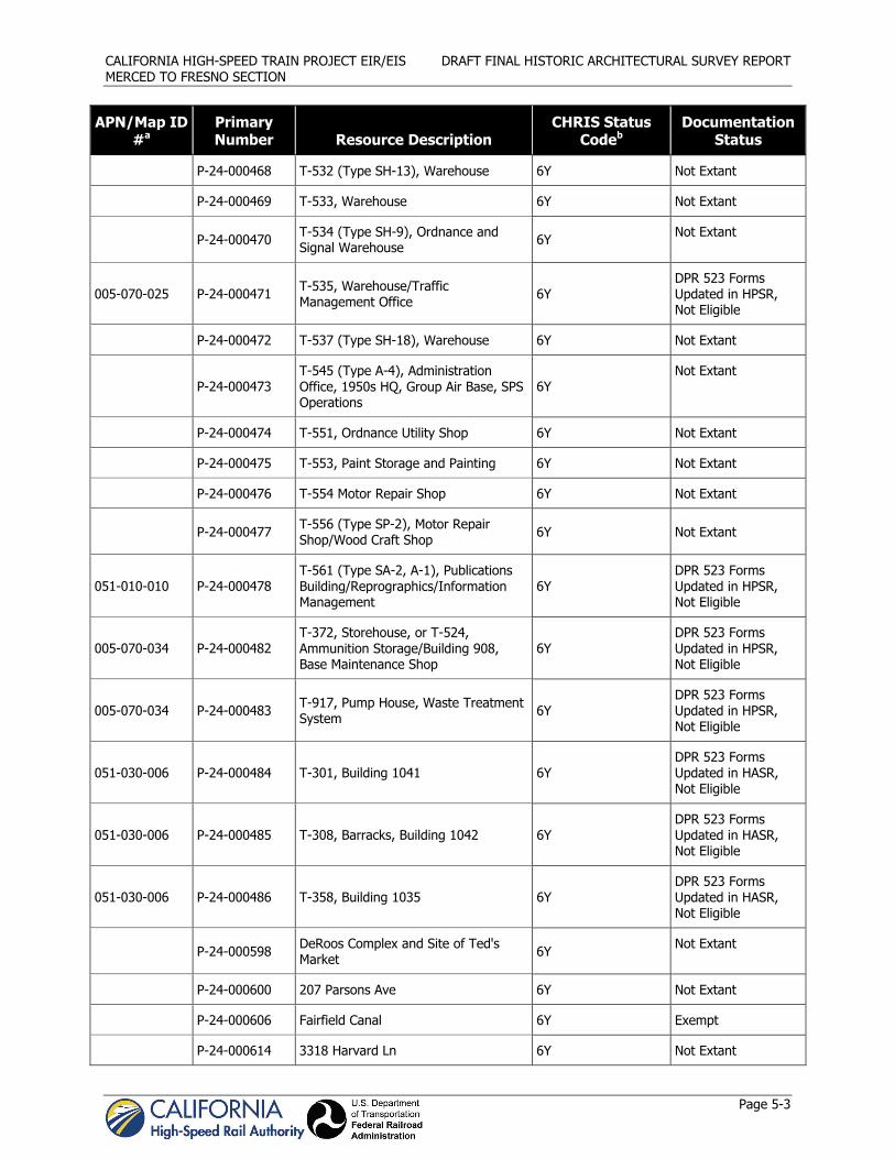
CALIFORNIA HIGH-SPEED TRAIN PROJECT EIR/EIS DRAFT FINAL HISTORIC ARCHITECTURAL SURVEY REPORT MERCED TO FRESNO SECTION
Page 5-3
APN/Map ID #a
Primary Number Resource Description
CHRIS Status Codeb
Documentation Status
P-24-000468 T-532 (Type SH-13), Warehouse 6Y Not Extant
P-24-000469 T-533, Warehouse 6Y Not Extant
P-24-000470 T-534 (Type SH-9), Ordnance and Signal Warehouse 6Y Not Extant
005-070-025 P-24-000471 T-535, Warehouse/Traffic Management Office 6Y
DPR 523 Forms Updated in HPSR, Not Eligible
P-24-000472 T-537 (Type SH-18), Warehouse 6Y Not Extant
P-24-000473 T-545 (Type A-4), Administration Office, 1950s HQ, Group Air Base, SPS Operations
6Y Not Extant
P-24-000474 T-551, Ordnance Utility Shop 6Y Not Extant
P-24-000475 T-553, Paint Storage and Painting 6Y Not Extant
P-24-000476 T-554 Motor Repair Shop 6Y Not Extant
P-24-000477 T-556 (Type SP-2), Motor Repair Shop/Wood Craft Shop 6Y Not Extant
051-010-010 P-24-000478 T-561 (Type SA-2, A-1), Publications Building/Reprographics/Information Management
6Y DPR 523 Forms Updated in HPSR, Not Eligible
005-070-034 P-24-000482 T-372, Storehouse, or T-524, Ammunition Storage/Building 908, Base Maintenance Shop
6Y DPR 523 Forms Updated in HPSR, Not Eligible
005-070-034 P-24-000483 T-917, Pump House, Waste Treatment System 6Y
DPR 523 Forms Updated in HPSR, Not Eligible
051-030-006 P-24-000484 T-301, Building 1041 6Y DPR 523 Forms Updated in HASR, Not Eligible
051-030-006 P-24-000485 T-308, Barracks, Building 1042 6Y DPR 523 Forms Updated in HASR, Not Eligible
051-030-006 P-24-000486 T-358, Building 1035 6Y DPR 523 Forms Updated in HASR, Not Eligible
P-24-000598 DeRoos Complex and Site of Ted's Market 6Y Not Extant
P-24-000600 207 Parsons Ave 6Y Not Extant
P-24-000606 Fairfield Canal 6Y Exempt
P-24-000614 3318 Harvard Ln 6Y Not Extant

CALIFORNIA HIGH-SPEED TRAIN PROJECT EIR/EIS DRAFT FINAL HISTORIC ARCHITECTURAL SURVEY REPORT MERCED TO FRESNO SECTION
Page 5-4
APN/Map ID #a
Primary Number Resource Description
CHRIS Status Codeb
Documentation Status
066-050-003 P-24-000615 1383-1385 Yale Ave 6Y DPR 523 Forms Updated in HPSR, Not Eligible
P-24-000616 3316 Harvard Ln 6Y Not Extant
P-24-000644 Bridge 39-1L 6Y, 7R,
Caltrans Category 5 Exempt
P-24-000646 Bridge 39-4L 7R,
Caltrans Category 5 Not Extant
P-24-000647 Bridge 39-6L 6Y, 7R,
Caltrans Category 5 Exempt
P-24-000649 Bridge 39-57L 6Y, 7R,
Caltrans Category 5 Exempt
P-24-000650 Bridge 39-59L 6Y, 7R
(not listed in Caltrans Inventory)
Not Extant
P-24-000657 Bridge 39-108L 7R,
Caltrans Category 5 Exempt
P-24-000738 Southern Pacific Freight Station 3S Not Extant
035-160-010 P-24-000737 Evergreen Memorial Park/De Long Memorial Park 5S2
DPR 523 Forms Updated in HPSR, CEQA Resource
034-205-005 P-24-000749 KAMB California Highway Patrol Building 3S
DPR 523 Forms Updated in HPSR, NRHP Eligible
P-24-000821 Cardwell Grain and Milling Company 3S Not Extant
031-211-018 P-24-000863 1424 Q St 7R DPR 523 Forms Updated in HASR, Not Eligible
P-24-000909 Little Snelling 5D2 Not Extant
P-24-000910 629 W 14th St 5D2 Not Extant
P-24-000911 637 W 14th St 5D2 Not Extant
P-24-000912 Joseph Couza Home 5D2 Not Extant
P-24-000913 729 W 14th St 3S Not Extant
P-24-000914 733 W 14th St 5D2 Not Extant
P-24-000915 743 W 14th St 5D2 Not Extant

CALIFORNIA HIGH-SPEED TRAIN PROJECT EIR/EIS DRAFT FINAL HISTORIC ARCHITECTURAL SURVEY REPORT MERCED TO FRESNO SECTION
Page 5-5
APN/Map ID #a
Primary Number Resource Description
CHRIS Status Codeb
Documentation Status
031-213-015 P-24-000916 Caswell T. Hunter Home 5S2 DPR 523 Forms Updated in HPSR, CEQA Resource
031-213-016 P-24-000917 Frank Bacigalupi Home 5S2 DPR 523 Forms Updated in HPSR, CEQA Resource
031-213-017 P-24-000918 Jacob Schafer Home 5S2 DPR 523 Forms Updated in HPSR, CEQA Resource
P-24-000919 911 W 14th St 5S2 Not Extant
031-243-004 P-24-000920 Merced Beverage and Supply Co. 3S DPR 523 Forms Updated in HPSR, CEQA Resource
035-010-005 P-24-000921 Merced County Hospital 3S
Recorded with “streamlined documentation” in HASR, Not Eligible
031-231-005 P-24-000922 PG&E Merced Receiving Station 3S DPR 523 Forms Updated in HPSR, NRHP Eligible
P-24-000923 632 W 15th St 5D2 Not Extant
P-24-000924 Mayflower Apartments 3S Not Extant
P-24-000925 706 W 15th St 3S Not Extant
P-24-000926 712 W 15th St 7N Not Extant
P-24-000927 Dan’s Appliance Repair 3S Not Extant
P-24-000928 742 W 15th St 3S Not Extant
P-24-000929 822 W 15th St 5S2 Not Extant
031-211-007 P-24-000930 912 W 15th St 5S2 DPR 523 Forms Updated in HPSR, CEQA Resource
P-24-000931 916 W 15th St 5S2 Not Extant
031-360-001
031-360-027 P-24-000932 Merced Southern Pacific Railroad
Station 3S DPR 523 Forms Updated in HPSR, NRHP Eligible
P-24-000933 64 W 16th St 7N Not Extant
031-162-013 P-24-000934 Hotel Des Pyrenees 7R
Recorded with “streamlined documentation” in HASR, Not Eligible

CALIFORNIA HIGH-SPEED TRAIN PROJECT EIR/EIS DRAFT FINAL HISTORIC ARCHITECTURAL SURVEY REPORT MERCED TO FRESNO SECTION
Page 5-6
APN/Map ID #a
Primary Number Resource Description
CHRIS Status Codeb
Documentation Status
031-154-011 P-24-000935 Oy Kuong Laundry/Ranch Restaurant 5S2 DPR 523 Forms Updated in HPSR, Not Eligible
031-152-012 P-24-000936 315 W 16th St 7R DPR 523 Forms Updated in HASR, Not Eligible
P-24-000942 Richfield Oil Company 5S2 Not Extant
P-24-001570 639 W 14th St 5D2 Not Extant
P-24-001696 Bridge 39-07 6Y,
Caltrans Category 5 Exempt
P-24-001711 Farmers Insurance 6Y Not Extant
P-24-001712 Bridge 39-58 6Y
(not listed in Caltrans Inventory)
Not Extant
P-24-001713 Bridge 39-99 6Y,
Caltrans Category 5
Not Extant
P-24-001714 Bridge 39-50 6Y
(not listed in Caltrans Inventory)
Not Extant
P-24-001715 Abandoned section of SR 99 6Y Exempt
P-24-001716 Bridge 39-100 6Y,
Caltrans Category 5 Exempt
059-330-006 P-24-001854 1732 N Hwy 99 6Y DPR 523 Forms Updated in HASR, Not Eligible
318-101-024 P-24-001877 ATSF Le Grand Railroad Station No Status Code Assigned
DPR 523 Forms Updated in HPSR, Not Eligible
P-24-001886 Doane Lateral 6Y Exempt
P-24-001909 Merced Irrigation District 3 Exempt
Madera County
P-20-002487 Mammoth Orange Drive-In 2S2, 7W Exempt, moved
P-20-002489 Boyd Lateral Canal 4S1/7N1 Exempt
P-20-002490 Califa Canal 4S1/7N1 Exempt
P-20-002491 Lateral 32.2 (Madera Canal) 3S Exempt

CALIFORNIA HIGH-SPEED TRAIN PROJECT EIR/EIS DRAFT FINAL HISTORIC ARCHITECTURAL SURVEY REPORT MERCED TO FRESNO SECTION
Page 5-7
APN/Map ID #a
Primary Number Resource Description
CHRIS Status Codeb
Documentation Status
011-320-001 P-20-002494 3 D’s Motel 3S DPR 523 Forms Updated in HASR, Not Eligible
P-20-002512 SR RR Bridge over Ash Slough No Status Code Assigned Exempt
No APN P-20-002519 Robertson Blvd Palm Trees 7L DPR 523 Forms Updated in HPSR, NRHP Eligible
P-20-002662 BNSF Railway between MP 1008.9 and 1013.9
No Status Code Assigned Exempt
P-20-002696 East Madera Underpass, Bridge 41-0027
7,
Caltrans Category 4 Exempt
Fresno County
No APN P-10-004513 Belmont Avenue Subway Caltrans Category 4 DPR 523 Forms Updated in HPSR, NRHP Eligible
P-10-005573 Herndon Canal 6Y Exempt
510-23-303
510-23-304 Not in HRI List Forestiere Underground Gardens 1S/1CL
DPR 523 Forms Updated in HPSR, NRHP Listed
450-02-008 Not in HRI List Roeding Park No Status Code Assigned
DPR 523 Forms Updated in HPSR, NRHP Eligible
No APN No Primary Number Assigned
Weber Ave Overcrossing (Bridge 42C0071)
2S2, 2S,
Caltrans Category 2
DPR 523 Forms Updated in HPSR, NRHP Eligible
a APN/Map ID numbers included for only those properties surveyed and evaluated in the HPSR and HASR reports.
b See Appendix D, California Historical Resource Status Codes, for description of status codes.Caltrans Category 2 = Eligible for National Register listing
Caltrans Category 4 = Unevaluated
Caltrans Category 5 = Ineligible for National Register listing
5.2 Consulting Parties, Public Participation
The PA sets forth the procedures for the identification and participation of consulting parties and the public in the Section 106 process for the project. Stipulation V, Part B of the PA requires that a list of consulting parties, a summary of coordination efforts, and public comments be submitted to the CASHPO for review, comment, and concurrence. That information, provided below, will be submitted as part of the HASR to the CASHPO and revised following the public comment period. The public, local agencies, and other interested parties have the opportunity to comment on the findings of the historic properties surveys at public meetings and through review of the Draft and Final EIS/EIR documents. Public participation will also be afforded in the Memorandum of Agreement (MOA) and treatment plan development process discussed in Stipulation VIII of the PA.

CALIFORNIA HIGH-SPEED TRAIN PROJECT EIR/EIS DRAFT FINAL HISTORIC ARCHITECTURAL SURVEY REPORT MERCED TO FRESNO SECTION
Page 5-8
Consultation with the CASHPO and the appropriate interested parties regarding potential effects on built environment properties has been ongoing throughout this project. As part of the outreach process, letters were sent to interested parties in 2009 and supplemental letters were sent in July 2010. No responses were received from the first (2009) and second (2010) round of letters. The recipients, listed below, include such interested parties as area museums and local historical societies, in compliance with the consultation requirements of NHPA and its implementing regulations (36 CFR 800). Interested parties contacted during this process included the following:
Clovis-Big Dry Creek Historical Society, in the Clovis Museum Fresno Art Museum Fresno City and County Historical Society Gustine Museum Kearney Mansion Museum Madera County Historical Society Merced County Historical Society and Merced County Courthouse Museum Society for California Archaeology Department of Anthropology, California State University, Fresno
As per PA stipulation V.A., these interest groups and interested individuals will be invited to comment on the treatments proposed, and those with demonstrated interest in the project will be invited to participate as consulting parties.
In addition to the interested party letters sent out in 2009 and 2010, a public meeting was held with the City of Fresno Historic Preservation Commission on September 19, 2011 to discuss findings in the Draft EIR/EIS on potential impacts to resources within the City of Fresno’s jurisdiction. The Historic Preservation Commission provided a staff report outlining questions and comments on the Draft EIR/EIS document. The Merced to Fresno section has responded as necessary by incorporating changes into the Final EIR/EIS and applicable technical reports.
Information collected during the public comment period for the Draft EIR/EIS were incorporated into the Final EIR/EIS and technical reports (HPSR, HASR, and ASR) following the public review period.
Additional Consulting Parties
FRA and the Authority are identifying all consulting parties for the MOA per Section 106 of the NHPA (see 36 CFR 800.2 (c) (3)). In December 2011, FRA and the Authority invited local governments to participate as consulting parties to comment on potential effects of the HST Project to historic properties within their jurisdiction. Potential consulting parties contacted during this process included the following:
City of Merced City of Madera Madera County City of Fresno Fresno County
As of January 2012, the City of Fresno and the City of Madera have accepted the invitation to become consulting parties (see Appendix B). Consulting parties will have the opportunity to review and comment on the FOE report and participate in the development of measures to avoid, minimize, and mitigate adverse effects to historic properties.
5.3 Field and Research Methodology
Project QIs conducted all intensive-level field survey and field research for preparation of this draft HASR during several periods between August 2010 and June 2011. Consistent with the PA and the Merced to Fresno Architectural Survey and Evaluation Plan (Authority and FRA 2009a), QIs conducted an intensive-level survey of properties within the APE that were 50 years of age or older at the time of survey (constructed in or before 1960) and that were not exempt from study, per Attachment D of the PA. All

CALIFORNIA HIGH-SPEED TRAIN PROJECT EIR/EIS DRAFT FINAL HISTORIC ARCHITECTURAL SURVEY REPORT MERCED TO FRESNO SECTION
Page 5-9
field survey was conducted from public thoroughfares, except in cases where the property owners were contacted and agreed to provide entry to properties not adequately visible from a public thoroughfare. Access to those properties was arranged in the manner specified in the project protocol for such contact, and the inventory was completed for these properties.
Once the built environment APE was defined (see Section 4.1), the QIs began fieldwork to account for all buildings, structures, and objects, districts, and landscapes found within the APE. This survey took into account known resources (see Table 5-1 above) and identified any additional resources that would require survey for the HASR, specifically those resources that not only appeared to be more than 50 years old, but also appeared to retain historic integrity. The resources surveyed as part of the HASR were not likely to be found eligible for listing in the NRHP or CRHR, but would not be destroyed, demolished, acquired, or substantially altered, as part of the proposed project. These resources were then subject to intensive-level survey, including recordation and evaluation on DPR 523 forms, which are presented in Appendix C.
Built environment resources that met the PA definition of “substantially altered properties” were recorded using a streamlined documentation format described in Appendix C of the PA. Because they do not retain integrity, they were not subject to full evaluation on DPR 523 forms. The PA also allows for streamlined documentation for tract homes and pre-fabricated homes more than 50 years of age that are not eligible for the National Register, but are not substantially altered. Resources subject to streamlined documentation are presented in Appendix D.
When certain common built environment resources were encountered during the field surveys, they were treated using the allowances noted in Attachment D of the PA: “Properties Exempt from Evaluation.” Given the proposed project’s location between Merced and Fresno in the Central Valley, these were largely limited to railroad, water supply, and highway features. Attachment D of the PA identifies categories of properties that do not warrant documentation and evaluation unless deemed otherwise in the professional judgment of QIs in the field. For these types of features, the exemptions were defined under three categories listed in Attachment D: Railroad Related Features; Water Conveyance and Control Features; and Highway and Roadside Features. Except in cases where related features had been previously listed or determined eligible for listing in the NRHP or CRHR through a formal consultation process, or were judged to be eligible for listing by the QIs in the field, no documentation was prepared.
To confirm specific construction dates for built environment resources and to narrow estimated dates of construction, background research was conducted through county assessor records and through review of historic plat maps, USGS topographic maps, historic aerial photographs, and other documents. Field survey and preliminary research helped to determine which resources were built in or before 1960. The QIs conducted property-specific research once identification of the intensive-level survey population was complete.
The historical overview presented in this report and the property-specific research conducted for the significance evaluations were based on a wide range of primary and secondary material gathered by historians and architectural historians. Research on the historic themes and survey population was conducted in both archival and published records, including but not limited to, California State Library – California History Room (Sacramento); California State Archives (Sacramento); California State Railroad Museum (Sacramento); Online Archive of California; Los Angeles Public Library Online Database Collections; Merced County Assessor’s Office; Merced County Planning and Community Development Department; City of Merced Planning Division; Merced County Library; Merced County Courthouse Museum/Merced County Historical Society; Madera County Assessor’s Office; City of Madera Planning Department; Madera County Library; Chowchilla Library; Fresno County Assessor’s Office; City of Fresno Planning and Development; Fresno County Library – California History and Genealogy Room; California State University, Fresno – Henry Madden Library.
The project historians and architectural historians also reviewed CHRIS, California Historical Landmarks and Points of Historical Interest publications and updates, the NRHP, the CRHR, and local register listings.

CALIFORNIA HIGH-SPEED TRAIN PROJECT EIR/EIS DRAFT FINAL HISTORIC ARCHITECTURAL SURVEY REPORT MERCED TO FRESNO SECTION
Page 5-10
In addition, the historians and architectural historians used published and digital versions of the population schedule of the U.S. Census Bureau information (U.S. Census Bureau 1850–1930).
Additionally, project QIs reviewed previous cultural resources reports, historic-period maps and atlases, historic photographs, aerial photography, local and state historical resources lists, and city directories. A review of the Caltrans “Historic Bridge Inventory” (Caltrans 2006) identified 14 bridges within the project limits; only one is listed as Category 2 (eligible for listing in the NRHP); two are listed as Category 4 (historical significance not determined); eight are listed as Category 5 (not eligible for listing in the NRHP); and two were not listed in the inventory. Weber Avenue Overcrossing and Belmont Avenue Subway were documented in the HPSR report, and the remaining 12 bridges were exempted according to guidelines set forth in the PA.

CALIFORNIA HIGH-SPEED TRAIN PROJECT EIR/EIS DRAFT FINAL HISTORIC ARCHITECTURAL SURVEY REPORT MERCED TO FRESNO SECTION
Page 6-1
6.0 Historic Context The cultural resources found in or likely to be encountered in the project area are a result of human behaviors within, and adaptations to, the environment. To better understand the origin and meaning of these resources, an environmental and cultural context must be established. The following paragraphs briefly describe the natural setting of the project area, and summarize cultural developments through the historic past.
6.1 Natural Setting
The HST project area is situated in the San Joaquin Valley (the Valley), a large north-south running basin in the central part of California. Geologically, the Valley has undergone periods of uplift and subsidence over millions of years. The Valley was filled with an interior ocean during the Jurassic and Cretaceous periods, up until the late Pliocene (circa [ca.] 5 million years ago). As a result, the Valley partially filled with sediment while inundated, then continued to fill with alluvial soils washed down from the Sierra Nevada and Coast Ranges. During the Pleistocene (ca. 2 million years ago) climate fluctuations alternately triggered depositional and erosional episodes in the region (DMJM+Harris 2004). The northern portion of the Central Valley is drained by the Sacramento River and the southern portion is drained by the San Joaquin River. The two rivers merge north of the project area, forming a system of channels and marshes comprising the Sacramento-San Joaquin Delta (Delta). The valley bottom is comprised of active alluvial fans along the mountain ranges, alkali basins and river floodplains consisting of well-sorted flood deposited soils; natural levees in these floodplains offered natural locations for prehistoric occupation (Rosenthal et al. 2007).
6.2 Historic Setting
6.2.1 San Joaquin Valley
Post-contact history for the state of California generally is divided into three specific periods: the Spanish Period (1769–1822), Mexican Period (1822–1848), and American Period (1848–present) (Schuyler 1978). Although there were brief visits by Spanish, Russian, and British explorers from 1529 to 1769 within the territory claimed by Spain, the Spanish Period in California began in earnest in 1769 with a settlement at San Diego and the first (Mission San Diego de Alcalá) of 21 missions established between 1769 and 1823.
During the Spanish Period, expeditions explored portion of the Central Valley beginning in the 1770s. In 1772, Pedro Fages led a small group of soldiers through the Tejon Pass into southernmost San Joaquin Valley, and 4 years later Francisco Garcés visited the same region (Wallace 1978:459). In the 1772 expedition Fages also explored the land east of San Francisco Bay, as did Juan Bautista De Anza in 1776, both remarking on the vast interior plains comprising the Central Valley, including the San Joaquin Valley, which is the portion of the Central Valley lying south of Sacramento-San Joaquin River Delta, located in Stockton, California (Gunsky 1989:2–3). In 1806 the Spanish expedition led by Lieutenant Gabriel Moraga, entered the San Joaquin Valley via Pacheo Pass while seeking sites for new missions and also searching for runaway Indian neophytes from the coastal missions. In 1808 Moraga led another expedition from the Bay area as far south as the Merced River. Moraga named the Kings River (El Río de los Santos Reyes) and the stream that flows into Lake Buena Vista (San Joaquin), an appellation was later applied to the San Joaquin River (Elliott 1882:167; Hoover et al. 1990:85). The final Spanish expedition into the California interior was led by Luis Arguello in 1817.
Two major north-south trails were established in California during the Spanish Period. El Camino Real connected the 21 missions that paralleled the coastline between San Diego and Sonoma. Today’s Interstate 5 between San Diego and Los Angeles and Highway 101 between Los Angeles and Petaluma generally follow “The King’s Highway.” In the interior, El Camino Viejo was the oldest north-south trail that traversed the entire length of the San Joaquin Valley; much of the trail lay east of the Coast Range and parallels the route of the HST approximately 30 miles to the west (Hoover et al. 2002:85; Elsmere Canyon website). “The Los Angeles Trail” connected today’s Los Angeles and East Oakland and was also

CALIFORNIA HIGH-SPEED TRAIN PROJECT EIR/EIS DRAFT FINAL HISTORIC ARCHITECTURAL SURVEY REPORT MERCED TO FRESNO SECTION
Page 6-2
later known as the Stockton–Los Angeles Road. The same route was a popular cattle and sheep trail from 1849 to the 1880s.
The Mexican Period begins with independence from Spain and is marked by an extensive era of land grants, most of which were in the interior of the state, and by exploration by American fur trappers west of the Sierra Nevada Mountains. In the northern San Joaquin Valley, land grants were issued in today’s Fresno, Merced, San Joaquin, and Stanislaus counties. Jedediah Smith was the first trapper to enter California. His small party trapped and explored along the Sierra Nevada Range in 1826, and entered the Central Valley in 1827. His party trapped and camped along the San Joaquin River, and his travels included friendly encounters with the Southern Valley Yokuts near the Kings River (Clough and Secrest 1984:27). Although the San Joaquin Valley was only sparsely settled during the Spanish and Mexican Periods, the Native American population was decimated by introduced diseases, particularly the malaria epidemic of 1833 (Cook 1978:98). Figure 6-1 depicts a portion of Mexico’s western territory, including California, at the end of the Mexican Period in 1847.
The signing of the Treaty of Guadalupe Hidalgo in 1848, ending the Mexican–American War, is the start of the American Period when California and several other western states became a territory of the United States (Gunsky 1989; Schuyler 1978). The discovery of gold in 1848 at Sutter’s Mill near Sacramento and the resulting Gold Rush era influenced the history of the state and the nation. Largely as a result of the Gold Rush, California became the 31st state in 1850. Thousands of settlers and immigrants continued to pour into the state, particularly after the completion of the transcontinental railroad in 1869. Many headed for the gold fields, but enterprising individuals and businesses met the increasing demand of the miners for commodities and food, boosting the agriculture, ranching, dairy, manufacturing, fishing, lumber, and transportation industries.
In the 1870s, the Central Pacific Railroad constructed its Southern Pacific line through the San Joaquin Valley to reach southern California, revolutionizing the transportation network, passenger travel, and the ability of farmers and ranchers to sell their goods to distant markets. No 19th century railroad-related structures survive from this period. Figure 6-2 shows the Southern Pacific Railroad at its completion in 1876. Chinese laborers made a noted contribution to the construction of the rail line, and settled in communities referred to as Chinatowns, including one in today’s City of Fresno (Hoover et al. 1990:171). During this period in the late 1800s, the San Joaquin Valley became the center of California’s wheat belt. While ranching remained an important industry, with the expansion of large-scale irrigation in the early 1900s came the production of a variety of fruits and vegetables, vineyards, alfalfa, and cotton, among other crops (Jelinek 1979:47–60).
The establishment of a state highway system in the early 1900s was the next major transportation development. Two north-south highways were planned through the Central Valley. One corresponds to today’s SR 99 in the interior; the second to U.S. Highways 1 and 101 along the western slope of the Coast Range. The routes were planned to pass through as many population centers as possible, and particularly the latter half of the 20th century witnessed the growth of existing and new residential, commercial, and industrial complexes along these routes and the modern freeway system. SR 99 was completed as a four-lane expressway between Sacramento and Los Angeles in the 1950s, and I-5 was completed in the 1970s.
6.2.2 Merced County
One of the first explorers to the California interior, Gabriel Moraga, set out from San Juan Bautista in 1806 with 25 men in search of a suitable location for an inland mission. Their route took them to a point along today’s Merced River. After difficult travel through wetlands, they found and named the river. Moraga explored the area again in 1808 and 1810 (Hoover et al. 1990:198). No mission was ever established within the interior, however, and the mission fathers considered the Moraga expeditions a failure.

CALI
FORN
IA H
IGH
-SPE
ED T
RAIN
PRO
JECT
EIR
/EIS
D
RAFT
FIN
AL H
ISTO
RIC
ARCH
ITEC
TURA
L SU
RVEY
REP
OR
T M
ERCE
D T
O F
RESN
O S
ECTI
ON
Pa
ge 6
-3
Figu
re 6
-1
Det
ail f
rom
Map
a de
los
Esta
dos
Unid
os d
e M
éjic
o, D
istu
rnel
l, 18
47
Appr
oxim
ate
proj
ect
loca
tion
in r
ed

CALIFORNIA HIGH-SPEED TRAIN PROJECT EIR/EIS DRAFT FINAL HISTORIC ARCHITECTURAL SURVEY REPORT MERCED TO FRESNO SECTION
Page 6-4
Figure 6-2 Southern Pacific Railroad in California, Colton, 1876
Approximate project location in red

CALIFORNIA HIGH-SPEED TRAIN PROJECT EIR/EIS DRAFT FINAL HISTORIC ARCHITECTURAL SURVEY REPORT MERCED TO FRESNO SECTION
Page 6-5
To accommodate the large numbers of miners heading to the Sierra Nevada Mountains during the Gold Rush, a toll road was constructed over Pacheco Pass and into Merced County in the 1850s (Hoover et al. 1990:199). Between 1858 and 1861, this route was traversed by the Butterfield overland stage line; rest stations were established along the route at 15-mile intervals. In 1870 the Southern Pacific line of the Central Pacific Railroad was constructed southward into the San Joaquin Valley, connecting the valley to Sacramento and San Francisco. Between Merced and Chowchilla, a post office was established in 1881 along the rail line at today’s unincorporated community of Athlone. Service at the Athlone post office was temporarily suspended in 1909 but resumed in 1914 and continued until it was officially closed in 1937 (Durham 1998:741). During the early growth period in the mid- to late-1880s, settlement along the railroad and the region’s waterways increased, and settlers raised livestock and grew a variety of crops. Small towns blossomed along the rivers, but the majority did not survive into later times because of floods, drought, or competition by the railroad (Hoover et al. 1990:203). While many of the towns that flourished for a time along the area’s rivers ultimately failed, other communities arose along the railroad, usually nucleated around a siding, construction depot, or station facility.
The county’s two largest population centers—Atwater and Merced—both developed and grew as a direct result of the railroad’s presence and the transportation services this modality offered. A discussion of these two cities can be found below.
Established in 1855 with the annexation of the southwestern portion of Mariposa County, Merced County derives its name from that given to Merced Lake, named for “Our Lady of Mercy” (Nuestra Señora de la Merced) by the Spanish expedition of 1775 led by Juan Bautista de Anza (Gudde 1998:234). The same name was given to the Merced River by members of the Spanish expedition led by Gabriel Moraga in 1806 (Hoover et al. 1990:198; Gudde 1998:234). The burgeoning City of Merced was named the county seat in 1872.
Although the bottom lands in the county are fairly well watered, particularly around the Merced and San Joaquin rivers, a series of canals were constructed beginning in the late 1860s to prevent flooding and control irrigation (Elliott 1882:170–171). Construction on the first extensive canal in the state, the San Joaquin and Kings River Canal, began in 1871. The 67-mile canal was completed in 1878. Figure 6-3 shows the irrigation system that then existed in Merced County in 1885.
The eastern portion of Merced County experienced an expansion of a profitable livestock industry. By the 1920s, the county had over 80,000 stock cattle and over 40,000 dairy cattle. Sheep and hogs were also raised in the fertile county grasslands (Outcalt 1925). Today, the county’s leading commodity is milk from dairy cows. Poultry (chicken, turkey, and eggs), cattle, and crops are also key economic products. Leading crops include almonds, sweet potatoes, tomatoes, alfalfa hay, and cotton (Merced County Agricultural Commission 2008).
6.2.2.1 City of Atwater
The City of Atwater is located in the central part of the San Joaquin Valley. Situated southwesterly of the former Castle Air Force Base and 6 miles west-northwest of the City of Merced, much of Atwater’s core lies between the Santa Fe Trail (County Road 37) and SR 99 in Merced County.
The history of today’s City of Atwater is rooted in the development of farmland in the northern San Joaquin Valley. Marshall D. Atwater began growth wheat on land in the area as early as 1869, and later rented 6,000 acres of farmland located between the Southern Pacific line and Winton (Atwater Chamber of Commerce 2007). In 1872, Atwater requested the railroad build a siding to handle his grain shipments. This stop later became known as the Atwater Switch.

CALIFORNIA HIGH-SPEED TRAIN PROJECT EIR/EIS DRAFT FINAL HISTORIC ARCHITECTURAL SURVEY REPORT MERCED TO FRESNO SECTION
Page 6-6
Attracted by the fertile farmland for growing fruits and other crops, plus the opening of a school at Atwater in 1878, settlement in the area slowly increased (Atwater Chamber of Commerce 2007). In 1884, George S. Bloss Sr. moved to Atwater with his family from Connecticut. The farmer built a two-story home by the railroad tracks in 1892, and another home on Cedar Avenue in 1913, referred to today as the Bloss home. Atwater’s burgeoning agricultural industry prospered in the early 1910s and with a related growth in population, rising from about 200 to 1,000 by the early 1920s (Sanborn 1914; 1923). U.S. census counts show that Atwater remained small through the Great Depression and did not begin to grow substantially until the economic upturn of the post war decades. Table 6-1 shows the population growth in Atwater from 1930 to 2000.
Atwater is also known for its adjacency to Castle Air Force Base. The U.S. Army established the base in 1941, and it housed the Army Air Corps Basic Flying School Winton (Atwater Chamber of Commerce 2007). Six Air Force Base buildings including two hangars, a maintenance building, and a barracks constructed between 1941 and 1942 are documented in this report (see updated DPR 523 forms in see Appendix C). Four Castle Air Force Base buildings were documented in the HPSR report. In 1946, the base fell under the control of the Strategic Air Command, and it remained active until it was closed in 1995 at the end of the Cold War. Today, vintage aircraft may be viewed at the Castle Air Museum at the former military facility.
Figure 6-3 Detail, Merced Irrigation Map, showing locations of the cities of Atwater and Merced, Hall, 1885
Approximate project location in red

CALIFORNIA HIGH-SPEED TRAIN PROJECT EIR/EIS DRAFT FINAL HISTORIC ARCHITECTURAL SURVEY REPORT MERCED TO FRESNO SECTION
Page 6-7
Table 6-1 Population Statistics,
City of Atwater 1930 – 2000
Year Population
1930 917
1940 1,235
1950 2,779
1970 11,640
1980 17,530
1990 22,282
2000 23,113
Sources: U.S. Census Bureau (1930); City of Atwater Department of Commerce (1950); Pacific Municipal Consultants (2000); US-Cities (n.d.)
6.2.2.2 City of Merced
The City of Merced nucleates around the intersection of SR 99 and U.S. Route 140 in the center of the eastern portion of Merced County.
The entry of the Central Pacific Railroad into the San Joaquin Valley in 1870 prompted creation of a town site and the start of construction of the future City of Merced, which was incorporated in 1889. The City’s growth and prosperity was largely a consequence of its location alongside the railroad, and entryway to the mines of the southern Mother Lode area during the Gold Rush years of the 1850s and 1860s (Hoover et al. 1990:203). An early tourism trade to Yosemite also brought impetus for growth in Merced. From the moment California received Yosemite from the federal government in 1864, the state planned the area as a park specifically geared to tourists. The completion of the transcontinental railroad in 1869 allowed eastern tourists to visit and extol the unique beauty of Yosemite. Since Yosemite initially had no direct connection by rail, visitors would travel across the valley in stagecoaches and then horseback to reach the park. This practice continued into at least the 1870s (Hyde 1993:69-72). Merced carries the moniker, “Gateway to Yosemite” and as early as 1872, the El Capitan Hotel in town served as the starting point for the stagecoaches carrying tourists to Yosemite.
By special election, the county seat was moved to the City of Merced in 1872. That year the city boasted two major hotels (El Capitan and Cosmopolitan), a variety of mercantile establishments, restaurants, livery stables, saloons, and grocers, as well as a post office, jail, school, and bank (Elliott 1882:112–115). The Tuolumne Hotel opened the following year. The Merced County Courthouse, a three-story edifice constructed in 1875 and located just outside the APE, is one of the oldest historical buildings in the state (Hoover et al. 1990:203). It is listed on the National Register of Historic Places and is now the Merced County Courthouse Museum.
The railroad continued to foster growth in Downtown Merced through the end of the 19th and early 20th centuries. Vestiges of the early 20th century residential, commercial, and industrial development close to the railroad still survive and fall within the APE for the Merced to Fresno Section. The survey population for the HASR contains a number of early 20th century buildings including several commercial buildings (APN: 031-152-010, 031-154-016, 031-360-014, 031-154-009); residences (APN: 031-211-008, 031-211-012, 031-211-013, 031-213-001, 031-213-004, 031-213-009, 031-203-014, 031-213-010); the Hotel Des Pyrenees (APN: 031-162-013); and the Merced County Hospital (APN: 035-010-005). The survey population for the HPSR also included several residences and commercial buildings along the existing railroad as well as a highway patrol building, electric substation, and the Merced Southern Pacific Railroad Station (1927).
CALIFORNIA HIGH-SPEED TRAIN PROJECT EIR/EIS DRAFT FINAL HISTORIC ARCHITECTURAL SURVEY REPORT MERCED TO FRESNO SECTION
Page 6-8
Located in the fertile northern San Joaquin Valley, the city continues to grow and prosper. It has always been an important shipping and exchange place, and the agriculture industry remains an important part of the area’s commerce. The city is served by two railroads, the Union Pacific and BNSF, and by three busy highways (SRs 59, 99, and 140). In 2005, the tenth campus of the University of California was completed in the city.
6.2.2.3 Le Grand
Le Grand serves as an exemplar among the smaller unincorporated communities that developed in Merced County as a direct result of the railroad. Originally known as “Idlewild” at its earliest period, the community of Le Grand grew to serve the farming district that still surrounds it. The town developed on land owned by Mrs. Luella Dickinson. When her husband, William Le Grand Dickinson, donated land to the San Francisco and San Joaquin Valley Railroad (now the BNSF) for a station, the railroad named the new stop “Le Grand.” The Dickinsons made their primary residence in Stockton, California. With the completion of the rail line, the Le Grand Station opened for traffic and the town quickly adopted the name. The ATSF Le Grand Railroad Station still stands alongside the south side of the railroad and is part of the survey population for the HPSR report. In September 1896, developers filed the first official “Town of Le Grand” subdivision map at the Merced County Courthouse. This plan platted the original 97 lots in town. Within a year, an additional 22 lots opened for development. Further development occurred in the early 20th century. Much of the HASR survey population in Le Grand consists of 1-story, stucco-over-frame, residences with side and front gable roofs that were constructed during the first quarter of the 20th century (APN: 318-140-002, 318-136-004, 318-061-001, 318-063-003, and 318-081-006). The Black Rock Milling Company, constructed in the 1920s, still survives adjacent to the railroad in Le Grand (APN: 318-140-001). The town grew, causing many businesses to relocate from Plainsburg to Le Grand. During 1908, most of the farmland surrounding Le Grand underwent subdivision into 5-, 10-, and 20-acre parcels and many of these parcels remain intact today. The number of building lots in town continued to grow through 1913, when Le Grand adopted the appearance it still retains today (Merced County Planning Department 1983:II-1; Gudde 2010:208).
6.2.3 Madera County
Spanish expeditions did not enter Madera County, possibly because of the maze of sloughs, sandy washes, and lack of water (Hoover et al. 1990:168). Trappers and explorers, such as Jedediah Smith, led the first historical accounts of visits to Madera County by non-indigenous peoples. Smith led a small group of hunters and trappers from Salt Lake City to the San Joaquin Valley in 1827, and again in 1828. In 1844, John Frémont traversed Madera County and recorded the difficulty of crossing the many sloughs in the area. Miners in the 1850s and 1860s often came through the area from Gilroy, over Pacheco Pass on the Stockton–Los Angeles Road, and journeyed on to the Sierra Nevada mines (Hoover et al. 1990:168–169).
One of the area’s pioneers was Major James D. Savage. Savage is credited with “discovering” the Yosemite Valley in 1851 (Madera County 2007). He turned from battling the local Native Americans in his early years to befriending them. Savage named the Yosemite Valley for the local tribe, the “Ah-wah-nee-chee,” who had family ties to the Mono Lake Paiutes on the eastern side of the Sierras. Savage was also known for employing Chinese laborers to work the San Joaquin River panning for gold. As another part of their contribution to the history of the county, Chinese laborers built many miles of rock walls in the area between Raymond and Mariposa, many of which are still standing.
Early mining in the Southern Mother Lode, which extended generally from the northwest to southeast throughout Merced County, was conducted by means of surface extraction of heavy minerals from sandy soils, known as placer mining (Hoover et al. 1990:169–170; Madera County 2007). This form of mining was practiced along the Fresno River and in places such as Coarsegold Gulch, Grub Gulch, and Gold Creek. The placer mines of Grub Gulch were very productive throughout the 1880s, accounting for the majority of gold extracted from the region.
The California State Legislature established Madera County in 1893 and named it after its principal town of Madera (Hoover et al. 1990:168). The lawmakers extracted the new county’s landmass from the

CALIFORNIA HIGH-SPEED TRAIN PROJECT EIR/EIS DRAFT FINAL HISTORIC ARCHITECTURAL SURVEY REPORT MERCED TO FRESNO SECTION
Page 6-9
portion of Fresno County north and west of the San Joaquin River. Madera County lies in the geographical center of the state. The completion in 1870 of the Southern Pacific line through the county and a demand from the eastern United States for lumber from Sierra Nevada forests combined to spur the growth of the town of Madera. To facilitate the transportation of cut trees to the railroad, a 63-mile water flume was constructed at a cost of a half million dollars (Hoover et al. 1990:170). With the completion of the flume in 1874, the town of Madera was settled and nucleated around the lower end of the flume. The town name is the Spanish word for wood (madera).
The Central Pacific established a series of rail stops and sidings along its route within Madera County in the late 1800s. From north to south, these include today’s incorporated communities of Minturn, Berenda, and Borden, among others. Local wheat farmers, Jonas and Thomas Minturn, constructed a railroad siding just northwest of Chowchilla when the railroad reached the area in 1872. The Minturn post office opened a decade later in 1884 and operated until 1922 (Durham 1998:804). Located on the north bank of Berenda Creek on the rail line between Chowchilla and Madera, a four-story hotel and a store were built in 1872 and a post office established at Berenda in 1873 (Durham 1998:745; Elliott 1882:199). The name was changed to Berenda in 1919, and the post office closed in 1935. With the coming of the railroad in 1872, the community of Borden was named in favor of a local community leader instead of the name of Arcola preferred by the original settlers who moved from Alabama in 1868 and established the earliest farm community (known as the Alabama Settlement) in this part of the San Joaquin Valley (Durham 1998:749; Hoover et al. 1990:171). By 1874 the lively town of Borden boasted two stores, two hotels, restaurants, stables, and a barber and physician (Elliott 1882:199). Eight years later, however, it had the appearance of a deserted mining camp. The Borden post office opened in 1873 and was officially closed in 1906. A post office was established in another small community along the rail line, Fairmead, in 1913 but closed in 1940 (Durham 1998:771).
6.2.3.1 City of Chowchilla
The City of Chowchilla extends southwesterly from the intersection of SR 99 and SR 233, which most of the city’s core flanking either side of Robertson Boulevard (SR 233). The city lies between the Ash Slough and the Berenda Slough.
Between the Chowchilla River and Berenda Slough, the Chowchilla post office opened in 1912, and the town incorporated in 1923 (Durham 1998:758). The name Chowchilla apparently derives from the name of the local tribe of Northern Valley Yokuts, who John Frémont mentioned during his forays into what is now Madera County.
The growth of the area and the city is attributed to Orlando A. Robertson, a land developer who invested some four million dollars in the purchase in May 1912 of the Chowchilla Ranch from the California Pastoral & Agricultural Company Ltd. (City of Chowchilla 2005). Robertson divided the acreage into tracts to sell to prospective farmers, but also reserved a portion as a town site. Town infrastructure included a water system, streetlights, and roads, including 12-mile Robertson Boulevard. By the time of the grand opening of this California colony in October 1912, the colony boasted 300 miles of country roads. Rooted in the concepts undergirding the American antebellum religious and utopian community movement, the colony movement for settling land in California began during the late 1850s and flourished during the final 30 years of the 19th century and into the early 20th century. The basis for virtually all colony land developments was a cooperative for constructing irrigation water canals and distribution systems. Individuals and even small groups could not undertake such activities, but the pooling of money and labor allowed all colony members to benefit (Clark 2001:52-55). The numerous colonies that dotted the southern San Joaquin Valley were unique with the Central Valley and provided a foundation for the flourishing agricultural production of the area today.
By 1887, five colonies existed in the vicinity of Fresno: Washington Colony; Central Colony; Church or Temperance Colony; the Scandinavian Colony; and the Nevada Colony. The developers divided each of these colonies into 20-acre lots and provided irrigation to produce crops of grapes, fruits, and vegetables (Enos 1887:188). In 1913, developer Robertson added 12 miles of track that connected to the Southern

CALIFORNIA HIGH-SPEED TRAIN PROJECT EIR/EIS DRAFT FINAL HISTORIC ARCHITECTURAL SURVEY REPORT MERCED TO FRESNO SECTION
Page 6-10
Pacific line as an additional guarantee of Chowchilla Colony’s success. Known as the Chowchilla Pacific Railroad, the now-abandoned tracks of this short line hosted train service for 40 years.
In 1917, Robertson purchased an adjacent 40,000 acres and with Chicago packer Louis Swift and started the successful Western Meat Ranch (City of Chowchilla 2005). Although management has changed, it continues as a cattle and farming operation. In 1919, Robertson bought and then sold tracts in the 26,000-acre Old Bliss Ranch. Although Robertson’s investments were profitable for development at Chowchilla, he lost much of his wealth as other land speculations crashed during the Depression era in the 1930s.
The series of palm trees that were planted in 1913 along Robertson Boulevard continue to signify this historic route. The width of the boulevard was planned as ample turnaround for a team of horses (City of Chowchilla 2005). The boulevard, also part of SR 233, is listed as a California Point of Historical Interest and is recommended eligible for the NRHP as part of the HPSR report. Not all California Points of Historical Interest are listed on the CRHR or the NRHP. Another early landmark, Hotel Chowchilla at the corner of Third and Robertson, was once one of the finest hotels in the state prior to several fires. The building later housed Woodbury’s variety store and is now occupied by Rose Furniture.
The majority of properties identified for this HASR fall within the rural areas of Chowchilla and consist of small, one-story residences constructed in the early to mid-20th century, are accompanied by several outbuildings associated with large-scale agricultural pursuits, and situated on large parcels. The largest money-making pursuits include dairy, grapes, almonds, and pistachios. Agricultural properties in the survey population that fit this description include APN: 025-020-016, 024-080-013, 027-071-017, and 024-141-003.
6.2.3.2 Fairmead
Fairmead Colony dates to 1912 when the Cooperative Land Trust Company of Palo Alto platted this land as a farming community. Fairmead mimicked the other colonies that proliferated throughout the southern San Joaquin Valley. In the initial developmental years, farmers within the Fairmead Colony produced bountiful crops of grains, alfalfa, vegetables, fruits, berries, and flowers. The Fairmead Post Office opened for service in 1913 and within three years of its founding, Fairmead comprised a growing collection of homes, churches, schools, boulevards, parks, and mercantile establishments, along with the attendant infrastructure. The Fairmead Inn, a newspaper, a lumberyard, and a blacksmith shop rounded out the business community during the second decade of the 20th century. Fairmead peaked about 1920 and then entered a gradually and extended state of decline. When the State Highway Department relocated SR 99 in 1930 away from Fairmead, it only exacerbated the colony’s economic woes and accelerated the closure of businesses and the loss of citizens to the growing population centers of Chowchilla and Madera. The dramatic decline in Fairmead’s population caused the United States Post Office Department to close the Fairmead postal facility in 1940. Little change or substantive improvements occurred in Fairmead since the 1940s and what remains of the old colony continues in a state of declination (Madera County Planning Department 2011:8; Durham 1998:771). No properties in the survey population fall within Fairmead.
6.2.3.3 City of Madera
The City of Madera nucleates around the intersection of SR 99 and SR 145 at a point about equidistant between Chowchilla and Fresno. Figure 6-4 illustrates how it looked in 1891.
On the banks of the Fresno River, today’s City of Madera was incorporated in 1907 and is the Madera County seat. The Southern Pacific Railroad came through the San Joaquin Valley and the area that would become Madera in 1872, providing the main transportation route into the valley (Solomon 1999:24). The railroad promoted growth and prosperity in the City of Madera through the end of the 19th century and into the early 20th century. The Madera Southern Pacific Railroad Station, constructed in 1927, still stands in Downtown Madera and is part of the survey population for the HPSR report. Originating as the town at the end of a 63-mile lumber flume, which the California Lumber Company completed in 1874, Madera rapidly developed. In 1876 the California Lumber Company laid out the town grid (Hoover et al.

CALIFORNIA HIGH-SPEED TRAIN PROJECT EIR/EIS DRAFT FINAL HISTORIC ARCHITECTURAL SURVEY REPORT MERCED TO FRESNO SECTION
Page 6-11
Figure 6-4 Map of Madera, Thompson, 1891
Approximate project location in red

CALIFORNIA HIGH-SPEED TRAIN PROJECT EIR/EIS DRAFT FINAL HISTORIC ARCHITECTURAL SURVEY REPORT MERCED TO FRESNO SECTION
Page 6-12
1990:170–171). Some of the first buildings erected in the city included a hotel, general store, and post office. The hotel (APN: 007-101-011) still survives in Downtown Madera and was recorded with streamlined documentation. Likewise, a string of two-story commercial buildings that also date from the 1880s survive in downtown Madera (though heavily altered) are part of the survey population for this HASR report and include APN: 007-101-005, 007-101-006, 007-101-008, 007-101-009, and 007-101-010. The Madera County Courthouse, constructed in 1900 of granite blocks, still stands today and is now the Museum of the Madera County Historical Society.
In addition to its historic and current connection with the lumber industry, the City of Madera is actively involved in the agricultural industry. Agricultural products such as fruit and nut crops, alfalfa and wheat, and a variety of vegetables are shipped all over the world from the City (Madera Agricultural Commissioner 2008). Situated alongside the railroad, the City of Madera contains a number of manufacturing enterprises and warehouses devoted to processing the county’s agricultural pursuits. The T.S. Woo Distributing in Downtown Madera was originally used for olive oil manufacturing. Other industrial operations in the APE include the Valley Feed & Fuel Co., Western Grain and Milling, and Evans Feed and Livestock Supply were documented as part of the HPSR report.
6.2.4 Fresno County
The Spanish bestowed the name fresno, or ash, upon the area where the City of Fresno now stands due to the many Oregon ash trees growing in the area along a creek (Gudde 1998:138). The first Europeans to traverse the area were with Captain Pedro Fages in 1772; next was Moraga’s 1806 expedition (Hoover et al. 1990:85; Johnson et al. 1993:29). During the early Spanish and Mexican Periods, most of the exploration conducted in the San Joaquin Valley was directed to either finding sites for new missions or retrieving the native neophytes who had run away from the coastal missions. In the later part of the Mexican Period during the 1840s, Kit Carson and John CA. Frémont explored the area.
The main branch of the El Camino Viejo, the oldest north-south trail that traversed the entire length of the San Joaquin Valley, passed through the western portion of Fresno County through the present towns of Reedley, Sanger, and Friant (Hoover et al. 1990:86). Used to drive cattle and wild horses to Los Angeles, the trail (later the Stockton–Los Angeles Road) followed the base of the Coast Range to Arroyo de Panoche Grande near Mendota and the project area (Clough and Secrest 1984:39).
The construction of the Southern Pacific line into the San Joaquin Valley in the 1870s led to the expansion of the livestock and farming industries in Fresno County, as well as the establishment of communities distributed along the tracks. Today’s City of Fresno was initially a railroad stop called Fresno Station. A post office was established in 1872 (Durham 1998:1038). Between Downtown Fresno and the San Joaquin River, today’s unincorporated community of Herndon was established in 1872 as Sycamore (Durham 1998:1046). A post office was opened at the Herndon rail stop in 1887 and temporarily closed in 1893, with service resuming in 1907.
Fresno County’s agricultural potential was recognized when the otherwise arid land was transformed by irrigation efforts, initiated as early as the 1850s with diversions from local rivers by individual farmers and private companies, a trend that continued throughout the 19th century with the incorporation of the Fresno Canal & Irrigation Company (Elliott 1882:102–103; Clough and Secrest 1984:115–117). One of the pioneers of irrigation in the county was Moses Church, who developed some of the area’s first canals, and was one of the partners of the Fresno Canal & Irrigation Company. His canals became known as “Church Ditches.” Irrigation fostered an era of extensive wheat farming throughout the San Joaquin Valley. By 1887, water from the canal systems irrigated over 600,000 acres within the county (Clough and Secrest 1984:187). Figures 6-5 and 6-6 show how Fresno County looked in 1885 and 1891.

CALI
FORN
IA H
IGH
-SPE
ED T
RAIN
PRO
JECT
EIR
/EIS
D
RAFT
FIN
AL H
ISTO
RIC
ARCH
ITEC
TURA
L SU
RVEY
REP
OR
T M
ERCE
D T
O F
RESN
O S
ECTI
ON
Pa
ge 6
-13
Figu
re 6
-5
Fres
no C
ount
y Ir
rigat
ion
Shee
t, H
all,
1885
Ap
prox
imat
e pr
ojec
t lo
catio
n in
red
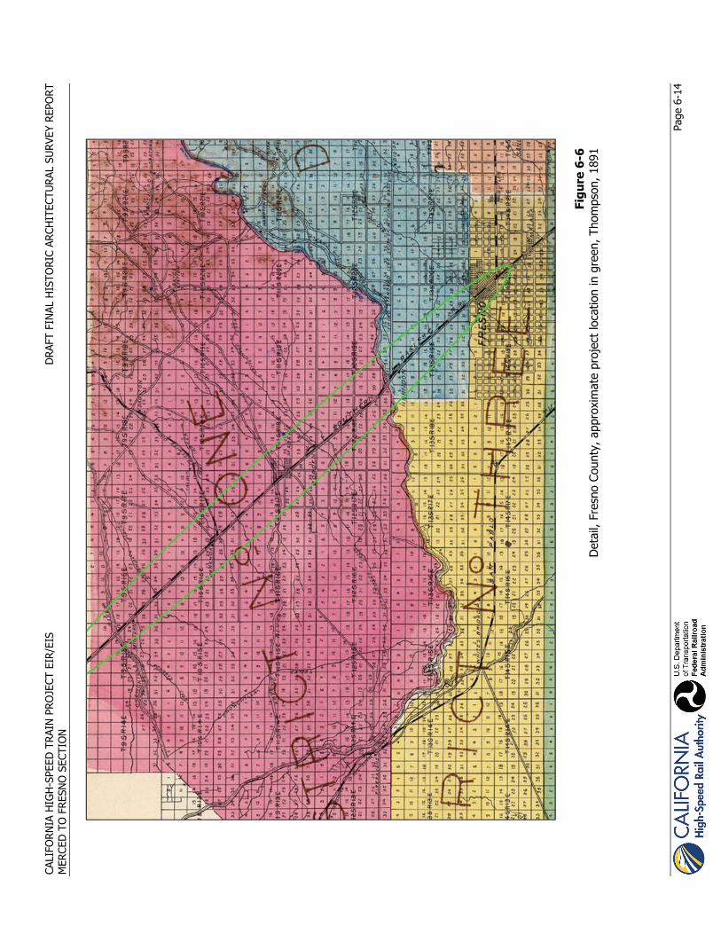
CALI
FORN
IA H
IGH
-SPE
ED T
RAIN
PRO
JECT
EIR
/EIS
D
RAFT
FIN
AL H
ISTO
RIC
ARCH
ITEC
TURA
L SU
RVEY
REP
OR
T M
ERCE
D T
O F
RESN
O S
ECTI
ON
Pa
ge 6
-14
Fi
gure
6-6
D
etai
l, Fr
esno
Cou
nty,
app
roxi
mat
e pr
ojec
t lo
catio
n in
gre
en, T
hom
pson
, 189
1

CALIFORNIA HIGH-SPEED TRAIN PROJECT EIR/EIS DRAFT FINAL HISTORIC ARCHITECTURAL SURVEY REPORT MERCED TO FRESNO SECTION
Page 6-15
Today, Fresno County is known as one of the most productive agricultural regions in the state. According to the county’s annual agricultural crop and livestock report for 2008, agricultural production in Fresno County was another record setting year “exceeding the five billion dollar-mark for the second time!” (Fresno Department of Agriculture 2008). This amount represents nearly a 6%increase from the 2007 production value—the first that exceeded five billion dollars—with increases in 2008 in field, seed, fruit and nut crops, livestock and poultry, and industrial crops.
6.2.4.1 City of Fresno
People began to settle the area that is now the City of Fresno when the town of Millerton flooded in 1867 (Hoover et al. 1990:87–88). The Central Pacific Railroad established a station stop for their Southern Pacific line and named it Fresno Station. A post office was opened at Fresno in 1872, and in 1874 the county seat was moved from Millerton to Fresno (Durham 1998:1038; Hoover et al. 1990:85, 89). The city was incorporated in 1897, and is now the largest city in the San Joaquin Valley.
In the center of the San Joaquin Valley, the City of Fresno is one of the largest agricultural industry trade centers (Hoover et al. 1990:89). The city is also known for the development of gravity irrigation. The people who came to the area to work the agricultural fields and related industries were not always content with the conditions that awaited them in San Joaquin Valley’s rich farmlands. From October 1910 until March 1911, the Industrial Workers of the World (IWW or “wobblies”) led California’s first free speech demonstration in the City of Fresno in their attempt to organize unskilled agricultural laborers (Clough and Secrest 1984:194–195).
The City of Fresno is the home of California’s first junior college. Fresno Junior College opened its doors in 1910, and the first enrollment of 28 students was taught by three teachers (Hoover et al. 1990:90). In 1958, the name of the school was changed to Fresno City College. The city also boasts the California State University at Fresno. The college began in 1911 as the State Normal School, and became a teaching college in 1921. In 1949, it began offering advanced degrees and currently has an enrollment of 20,000 students (California State University at Fresno 2008).
Fresno is home to a variety of ethnic groups, beginning in 1885 with the settlement of the Chinese rail laborers who were instrumental in the construction of the Southern Pacific line. The Chinese rail laborers settled on the west side of the city and by the late 1880s were joined in the Chinatown District by other ethnic groups (Clough and Secrest 1984:36–37, 77). In the early 1890s, Fresno’s was the second largest Chinatown in the state, the population exceeded only by that in San Francisco. In the mid-1900s, urban renewal and the construction of SR 99 through West Fresno destroyed much of Chinatown and the old tenderloin district. Recently, however, the city is engaged in downtown revitalization efforts and creating a Specific Plan to regulate development and preserve its past, including the Chinatown Historic District (City of Fresno 2010). Bordered by SR 99 on the west, the tracks of the Union Pacific Railroad on the east, Fresno Street on the north, and Ventura Street on the south, the district includes the Downtown Fresno Station, which would be used by the HST project.
Following the establishment of Fresno’s Chinatown by Chinese railroad workers, other ethnic groups began to settle in Fresno’s Chinatown District during the 20th century. The new arrivals included a large Armenian population, who upon finding a climate and soils similar to those in Armenia, became adept at producing nuts and fruits, including figs, melons, pistachio nuts, and raisins (Hoover et al. 1990:91). During the first years of World War II, Fresno had two assembly centers for temporary detention of Japanese Americans—one at the fairgrounds and another in Pinedale, just north of the city, both of which are California Historical Landmarks. The detention centers were meant to hold people of Japanese ancestry until permanent centers could be established. Many of the Japanese from the Fresno area went to more permanent relocation centers at Manzanar and Tule Lake.
The City of Fresno has the unusual distinction of establishing the first modern landfill in the United States. The Fresno Municipal Sanitary Landfill was the site of many innovations in sanitary landfill operations, such as trenching, compacting, and covering the landfill with soil on a daily basis. The municipal landfill began operating in 1937 but closed in 1987. The site of the landfill is now listed as a National Historic

CALIFORNIA HIGH-SPEED TRAIN PROJECT EIR/EIS DRAFT FINAL HISTORIC ARCHITECTURAL SURVEY REPORT MERCED TO FRESNO SECTION
Page 6-16
Landmark and is located approximately 3 miles west of the HST at the southwest corner of West Jensen Avenue and South West Avenue. Similar to other California cities, a network of street cars operated in the urban center starting in 1889, progressing from horse-drawn to steam, cable, and electric (Clough and Secrest 1986:247–251). The urban street car network ended in 1939.
Today, the economy of the City of Fresno remains tied to the agricultural sector; the service industry also makes a substantial contribution to the area’s income. At the geographic center of the valley, Fresno is considered to be the hub for commerce, industry, education, health care, and government in northern San Joaquin Valley.
CALIFORNIA HIGH-SPEED TRAIN PROJECT EIR/EIS DRAFT FINAL HISTORIC ARCHITECTURAL SURVEY REPORT MERCED TO FRESNO SECTION
Page 7-1
7.0 Built Environment Resources Identified as Not Eligible for the NRHR or the CRHR
This chapter summarizes the inventory and evaluation of the built environment resources presented in this HASR. The built environment resources inventoried and evaluated in this HASR reflect the major historical events discussed in the historical context for the study corridor that stretches from Atwater in Merced County, through the Downtown Merced, through Chowchilla, to Downtown Madera, and terminates in Downtown Fresno. Although the survey area covers a region that includes portions of three counties, the majority of resources surveyed herein are in, or in the immediate vicinity of, the cities of Merced, Madera, and Fresno. A lesser number of properties are in the rural areas of Merced, Madera, and Fresno counties.
There are 400 ineligible properties that were identified as part of this HASR report. None of the properties in Table 7-1 appear to meet the criteria for listing on NRHP. They are also not eligible for listing in the CRHR and are not considered historical resources for the purposes of CEQA. Full documentation for ineligible properties that are not substantially altered is included on the associated DPR forms in Appendix C. Streamlined documentation is located in Appendix D for ineligible properties that are substantially altered and ineligible pre-fabricated homes that are not substantially altered.
7.1.1.1 Ineligible Built Environment Resources
Residential properties make up the vast majority of built environment resources located within the APE. In Merced, the residential properties included Craftsman bungalows (APN 031-213-010 and 031-211-013), and Folk styles (APN 031-211-008 and 031-213-004). Residences within the APE in Madera included Folk Victorian style (APN 007-054-003), Craftsman bungalow style (APN 007-043-003 and 001-190-012), Ranch styles (APN 003-080-022 and 003-080-022), Minimal Traditional styles (APN 003-080-007 and 003-010-004). Residences in Fresno consisted primarily of frame, single-family dwellings dating to the mid-20th century. A large majority of residential properties documented within the APE for the project date to the 20th century, between 1925 and 1960. The residences are typically plain in design, with little architectural style, and most have been altered. These properties are indicative of the general growth and development of Merced, Le Grand, Chowchilla, Madera, and Fresno during the 20th century.
Industrial and large commercial buildings were also present within the APE for the project, primarily located in the urbanized areas of Merced, Madera, and Fresno lining the active railroad corridors. In Fresno, large industrial complexes include APN 458-24-039 and APN 458-25-015. In Madera industrial complexes include 011-151-003 and 011-073-003. An industrial complex recorded in Merced for this HASR report includes 031-360-014. These 20th century industrial and commercial buildings are constructed of a wide range of materials, from concrete block to brick to frame, and most are utilitarian in design with few decorative elements. They represent the early to mid-20th century industrial and commercial growth of the cities along the active rail lines.
A smaller number of military, institutional, and government and buildings are located within the APE. The Castle Air Force Base in Atwater contains a number of remnant mid-20th century hangars (051-010-010), barracks (APN 051-030-006), and maintenance buildings (APN 051-010-010). Most are utilitarian in plan and simple in design, are constructed of wood frame and have been altered in some capacity since their construction. The Merced County Hospital located outside Downtown Merced was constructed in the early-20th century with its earliest buildings designed in the Spanish Revival and Art Deco styles but has undergone considerable expansion over the years and contains many late-20th century intrusions. The California Department of Motor Vehicles property (APN 450-18-101) in Fresno contains masonry and frame shop buildings dating from the early-20th century and the brick and steel main office building (which replaced the original 1926 building) that dates to 1963.
There are a number of rural agricultural resources within the APE for the project, primarily in the rural areas of Madera. The agricultural complexes usually contain a residence, support buildings, and farmland, orchards, or pastures. Ranches and farmsteads are commonly found throughout the Chowchilla area,

CALIFORNIA HIGH-SPEED TRAIN PROJECT EIR/EIS DRAFT FINAL HISTORIC ARCHITECTURAL SURVEY REPORT MERCED TO FRESNO SECTION
Page 7-2
within the APE. Examples documented in the HASR report include APN 025-020-016, 024-080-013, and 027-071-017 in Madera County and APN 259-150-014, 059-330-006, and 067-010-027 in Merced County. These rural complexes represent the agricultural development of the San Joaquin Valley during the early 20th century.
Table 7-1 Built Environment Resources that do not appear Eligible for the NRHP or CRHR
APN Name Address City County Year Built
Previous Status Code
Current Status Code
Appendix C: Ineligible, recorded with full DPR 523 Forms
005-090-023 Migliazzo and Sons Dairy
3645 Bradshaw Rd Atwater Merced ca. 1940 6Z
005-100-003 4149 and 4085 Fox Rd Atwater Merced ca. 1930 6Z
005-100-004 4075 Fox Rd Atwater Merced ca. 1957 6Z 005-100-005 4065 Fox Rd Atwater Merced 1958 6Z
051-010-010
T-51, Repair Hangar, Building 51 51 Apron Ave Atwater Merced ca. 1941 6Y 6Z
051-010-010
T-54, Line Maintenance Building, Building 54 54 Apron Ave Atwater Merced ca. 1944 6Y 6Z
051-030-006
T-308, Barracks, Building 1042
1042 Castle Air Museum Atwater Merced ca. 1942 6Z
051-030-006 T-301, Building 1041
1041 Santa Fe Dr. Atwater Merced ca. 1941 6Z
051-030-006 T-358, Building 1035
1045 Castle Air Museum Atwater Merced ca. 1942 6Z
053-260-032 9022 E Mission Ave Le Grand Merced ca. 1960 6Z
067-010-027 1953 S Burchell Ave Le Grand Merced
ca. 1918 ca. 1950 6Z
067-050-013 2264 S Plainsburg Rd Le Grand Merced 1931 6Z
068-230-046 3334 S Cunningham Rd Le Grand Merced ca. 1930 6Z
068-230-046 3334 S Cunningham Rd Le Grand Merced ca. 1930s 6Z
068-250-062 Santa Fe Ave Le Grand Merced ca. 1918 6Z
318-063-003 3765 Santa Fe Ave Le Grand Merced ca. 1927 6Z
318-063-004 3779 Santa Fe Ave Le Grand Merced 1910 6Z
318-081-006 3915 Santa Fe Ave Le Grand Merced 1925 6Z
318-081-012 13289 E Jefferson St Le Grand Merced ca. 1918 6Z
318-083-010 14271 Madison St Le Grand Merced 1958 6Z
318-140-001
Black Rock Milling Company
13461 Le Grand Rd Le Grand Merced 1925 6Z
318-140-011 4185 Fresno Rd Le Grand Merced ca. 1960 6Z

CALIFORNIA HIGH-SPEED TRAIN PROJECT EIR/EIS DRAFT FINAL HISTORIC ARCHITECTURAL SURVEY REPORT MERCED TO FRESNO SECTION
Page 7-3
APN Name Address City County Year Built
Previous Status Code
Current Status Code
067-030-022 7815 Mission Ave
Le Grand--Changed to match DPR form 12/27/11 CR Merced 1959 6Z
031-152-012 Sanchez Appliance 315 W 15th St Merced Merced ca. 1927 7R 6Z
031-154-009 San Benito Glass, Inc. 229 W 16th St Merced Merced ca. 1928 6Z
031-164-009
Weaver's Smog and Repair 1609 G St Merced Merced ca. 1955 6Z
031-164-014 1639 G St and 2-14 W Main St Merced Merced ca. 1940 6Z
031-201-004 Smith Van & Storage, Inc.
1120-1160 W 15th St Merced Merced ca. 1955 6Z
031-203-014 1045 14th St Merced Merced ca. 1935 6Z
031-211-018 1420 and 1424 Q St Merced Merced
ca. 1940 ca. 1885 7R 6Z
031-213-010 803 W 14th St Merced Merced ca. 1920 6Z
031-352-002 Ralph's Auto Sales 1590 W 16th St Merced Merced ca. 1955 6Z
031-352-010
Bad Boys Wheels and Tires 1566 W 16th St Merced Merced ca. 1928 6Z
031-360-061 The Branding Iron 640 W 16th St Merced Merced ca. 1936 6Z
057-310-014
NW corner Beachwood Dr and Ashby Rd Merced Merced ca. 1946 6Z
057-380-032 2691 W Lobo Ave Merced Merced ca. 1919 6Z
057-590-018 2687 Dan Ward Rd Merced Merced ca. 1950 6Z
059-330-006 1732 N Hwy 99 Merced Merced ca. 1934 6Y 6Z
066-010-014 5101 and 5017 E Mission Ave Merced Merced
c. 1930 and c. 1960 6Z
066-032-003 3421 E Mission Ave Merced Merced ca. 1954 6Z
066-040-006 1093 Lawndale Ave Merced Merced 1961 6Z
066-050-014 1326 Yale Ave Merced Merced 1959 6Z
067-030-016 1050 S Arboleda Dr Merced Merced 1931 6Z
067-180-014 6863 Plainsburg Rd Merced Merced 1960 6Z
075-100-003 7877 E Sandy Mush Rd Merced Merced ca. 1960 6Z
075-100-017 Cross Rd Merced Merced ca. 1940 6Z
259-150-013 1330 E Childs Ave Merced Merced ca. 1920 6Z
024-070-034 12583 Avenue 21 Chowchilla Madera ca. 1920 6Z 024-141-003 13570 Avenue 21 Chowchilla Madera ca. 1946 6Z 024-141-010 20610 Road 14 Chowchilla Madera ca. 1960 6Z 024-141-029 13830 Avenue 21 Chowchilla Madera ca. 1946 6Z

CALIFORNIA HIGH-SPEED TRAIN PROJECT EIR/EIS DRAFT FINAL HISTORIC ARCHITECTURAL SURVEY REPORT MERCED TO FRESNO SECTION
Page 7-4
APN Name Address City County Year Built
Previous Status Code
Current Status Code
024-142-007 14501 Avenue 20½ Chowchilla Madera ca. 1958 6Z
025-070-009 11417 Avenue 25 Chowchilla Madera ca. 1950 6Z
025-120-006 10391 and 10397 Avenue 24 Chowchilla Madera ca. 1920s 6Z
026-110-008 14690 Avenue 27 Chowchilla Madera ca. 1960 6Z
026-232-021 24276 Robertson Blvd Chowchilla Madera ca. 1925 6Z
026-240-063 24349 Road 15 Chowchilla Madera ca. 1950 6Z
026-271-057 23741 Robertson Blvd. Chowchilla Madera ca. 1920s 6Z
026-280-002 15404 Avenue 24 Chowchilla Madera ca. 1946 6Z
026-280-003 23728 Road 15 3/4 Chowchilla Madera ca. 1946 6Z
026-280-007 23682 Road 15¾ Chowchilla Madera ca. 1950 6Z 027-054-034 18481 Gordon St Chowchilla Madera ca. 1960 6Z 027-061-009 18643 Arc Dr. Chowchilla Madera ca. 1918 6Z 027-135-005 22471 Maple St Chowchilla Madera ca. 1920s 6Z 027-135-015 22465 Maple St Chowchilla Madera ca. 1920s 6Z 027-222-002 Merriam Farms 20759 Road 19 Chowchilla Madera ca. 1930 6Z 026-130-004 16329 Avenue 26 Chowchilla Madera ca. 1948 6Z
027-054-021 23545 Fairmead Blvd Chowchilla Madera ca. 1960 6Z
027-131-003 22564 Fir St Chowchilla Madera ca. 1960 6Z 003-010-003 724 Sonora St Madera Madera ca. 1948 6Z
003-080-007 316 Cleveland Ave Madera Madera ca. 1950 6Z
003-080-021 317 Wilson Ave Madera Madera ca. 1957 6Z 003-080-028 325 Wilson Ave Madera Madera ca. 1955 6Z
006-010-003 117 W Central Ave Madera Madera ca. 1957 6Z
007-012-011 125 E Central Ave Madera Madera ca. 1940 6Z
007-012-012 115 E Central Ave Madera Madera ca. 1950 6Z
007-041-004 Enterprise Rent-a-Car
709 N Gateway Dr Madera Madera ca. 1929 6Z
007-041-008 625 N Gateway Dr Madera Madera ca. 1948 6Z
007-041-009 703 N Gateway Dr Madera Madera ca. 1957 6Z
007-043-001 130 E Central Ave Madera Madera ca. 1950 6Z
007-043-003 107 E 1st St Madera Madera 1916 6Z
007-043-007 West and West Enterprises 609 N. E St Madera Madera 1941 6Z
007-043-008 105 E. 1st St Madera Madera 1925 6Z 007-053-001 520 N. D St Madera Madera ca. 1929 6Z 007-053-002 518 N. D St Madera Madera ca. 1926 6Z 007-053-004 512 N. D St Madera Madera ca. 1926 6Z 007-053-006 500 N. D St Madera Madera ca. 1898 6Z 007-053-010 511 N. E St Madera Madera 1944 6Z 007-054-001 424 N. D St Madera Madera ca. 1898 6Z 007-054-002 420 N. D St Madera Madera ca. 1891 6Z 007-054-003 416 N. D St Madera Madera ca. 1898 6Z 007-054-004 408 N. D St Madera Madera ca. 1956 6Z

CALIFORNIA HIGH-SPEED TRAIN PROJECT EIR/EIS DRAFT FINAL HISTORIC ARCHITECTURAL SURVEY REPORT MERCED TO FRESNO SECTION
Page 7-5
APN Name Address City County Year Built
Previous Status Code
Current Status Code
007-075-004 308 N. D St Madera Madera ca. 1912 6Z 007-075-009 309 N. E St Madera Madera ca. 1948 6Z
007-075-012 312 & 316 N. D St Madera Madera ca. 1958 6Z
007-076-007 200 N. D St Madera Madera ca. 1930 6Z
007-076-012 George's Auto Supply 150 E 4th St. Madera Madera ca. 1961 6Z
007-151-007 125 S Gateway Dr Madera Madera ca. 1948 6Z
007-153-004 112 S D St/134 E Yosemite Ave Madera Madera ca. 1912 6Z
007-153-005 Yosemite Pharmacy
136 E Yosemite Ave Madera Madera ca. 1912 6Z
007-154-004 214 S. D St Madera Madera 1956 6Z
007-154-008 Buick Dealership 100 E. 6th St Madera Madera 1954 6Z
007-154-012 218 S. D St Madera Madera 1954 6Z 007-183-002 238 S. D St Madera Madera ca. 1911 6Z 007-183-004 221 S. E St Madera Madera ca. 1957 6Z 007-184-017 316 S. D St Madera Madera ca. 1926 6Z 007-184-022 Boyle Electric 308 S. D St Madera Madera ca. 1920 6Z
011-011-001 409 S Gateway Dr. Madera Madera ca. 1957 6Z
011-012-008 112 Clinton St Madera Madera ca. 1957 6Z 011-043-002 504 S. D St Madera Madera ca. 1926 6Z 011-043-004 512 S. D St. Madera Madera ca. 1926 6Z 011-043-005 516 S. D St. Madera Madera ca. 1926 6Z
011-043-007
Southern Pacific Railroad Freight House 501 S. E St Madera Madera ca. 1929 6Z
011-074-011 600 S. D St Madera Madera ca. 1948 6Z 011-112-002 704 S. D St Madera Madera ca. 1954 6Z 011-112-003 708 S. D St. Madera Madera ca. 1948 6Z 011-112-004 712 S. D St Madera Madera ca. 1948 6Z
011-151-004 H & M Auto Repair
815 S Gateway Dr Madera Madera ca. 1948 6Z
011-151-006 827 S Gateway Dr Madera Madera ca. 1926 6Z
011-152-002 804 S. D St Madera Madera ca. 1926 6Z 011-152-004 812 S. D St. Madera Madera ca. 1950 6Z 011-152-005 816 S. D St Madera Madera ca. 1926 6Z 011-152-007 113 E 13th St Madera Madera ca. 1922 6Z
011-201-002
NE corner of E 14th St and E Olive Ave Madera Madera ca. 1957 6Z
011-300-010 644 E Olive Ave Madera Madera ca. 1947 6Z
011-320-001 3 D's Motel 1100 S Gateway Dr Madera Madera ca. 1947 6Z
011-330-010 726 S Knox St Madera Madera ca. 1947 6Z
013-110-038 1500 N Gateway Dr Madera Madera ca. 1957 6Z
013-120-003 900 N Gateway Dr Madera Madera ca. 1947 6Z
029-140-010 24868 Avenue 20½ Madera Madera ca. 1957 6Z
029-180-005 19742 Hw 99 Madera Madera ca. 1918 6Z
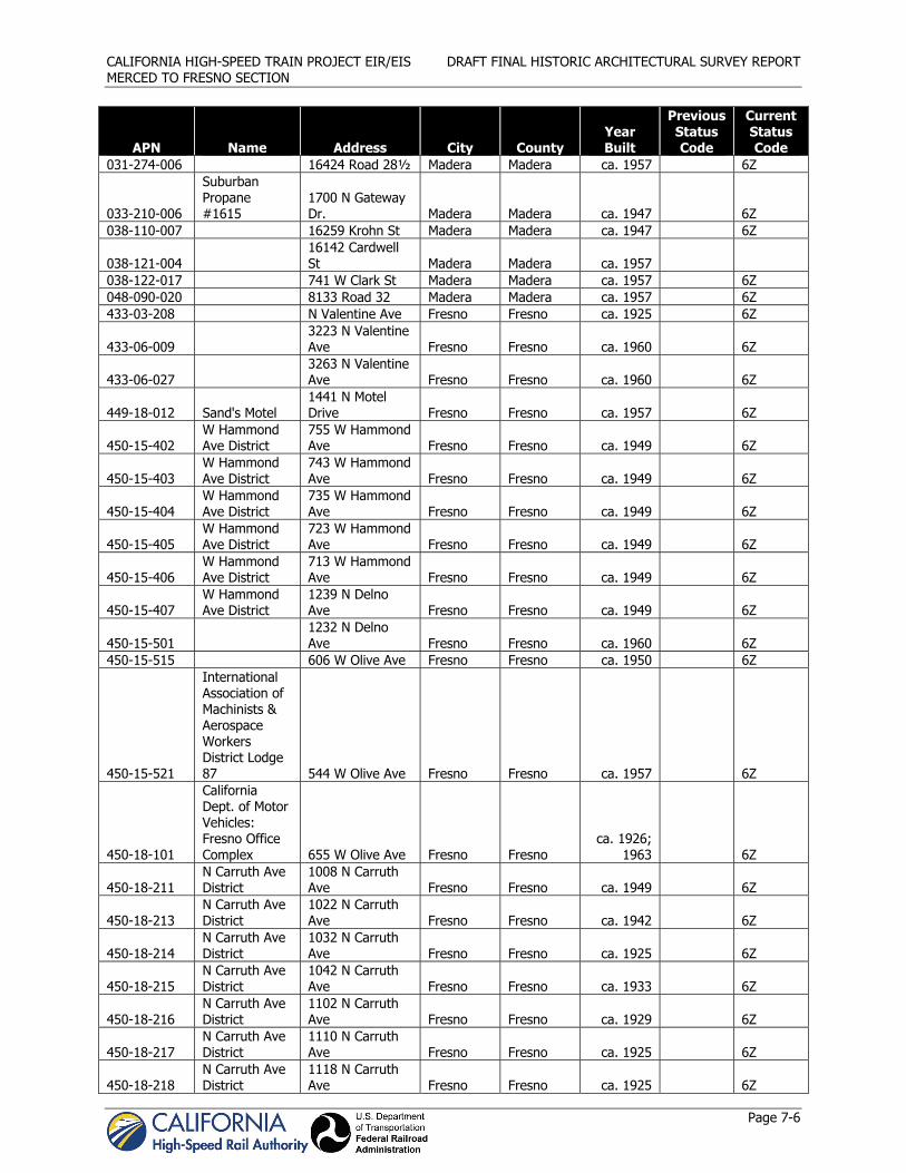
CALIFORNIA HIGH-SPEED TRAIN PROJECT EIR/EIS DRAFT FINAL HISTORIC ARCHITECTURAL SURVEY REPORT MERCED TO FRESNO SECTION
Page 7-6
APN Name Address City County Year Built
Previous Status Code
Current Status Code
031-274-006 16424 Road 28½ Madera Madera ca. 1957 6Z
033-210-006
Suburban Propane #1615
1700 N Gateway Dr. Madera Madera ca. 1947 6Z
038-110-007 16259 Krohn St Madera Madera ca. 1947 6Z
038-121-004 16142 Cardwell St Madera Madera ca. 1957
038-122-017 741 W Clark St Madera Madera ca. 1957 6Z 048-090-020 8133 Road 32 Madera Madera ca. 1957 6Z 433-03-208 N Valentine Ave Fresno Fresno ca. 1925 6Z
433-06-009 3223 N Valentine Ave Fresno Fresno ca. 1960 6Z
433-06-027 3263 N Valentine Ave Fresno Fresno ca. 1960 6Z
449-18-012 Sand's Motel 1441 N Motel Drive Fresno Fresno ca. 1957 6Z
450-15-402 W Hammond Ave District
755 W Hammond Ave Fresno Fresno ca. 1949 6Z
450-15-403 W Hammond Ave District
743 W Hammond Ave Fresno Fresno ca. 1949 6Z
450-15-404 W Hammond Ave District
735 W Hammond Ave Fresno Fresno ca. 1949 6Z
450-15-405 W Hammond Ave District
723 W Hammond Ave Fresno Fresno ca. 1949 6Z
450-15-406 W Hammond Ave District
713 W Hammond Ave Fresno Fresno ca. 1949 6Z
450-15-407 W Hammond Ave District
1239 N Delno Ave Fresno Fresno ca. 1949 6Z
450-15-501 1232 N Delno Ave Fresno Fresno ca. 1960 6Z
450-15-515 606 W Olive Ave Fresno Fresno ca. 1950 6Z
450-15-521
International Association of Machinists & Aerospace Workers District Lodge 87 544 W Olive Ave Fresno Fresno ca. 1957 6Z
450-18-101
California Dept. of Motor Vehicles: Fresno Office Complex 655 W Olive Ave Fresno Fresno
ca. 1926; 1963 6Z
450-18-211 N Carruth Ave District
1008 N Carruth Ave Fresno Fresno ca. 1949 6Z
450-18-213 N Carruth Ave District
1022 N Carruth Ave Fresno Fresno ca. 1942 6Z
450-18-214 N Carruth Ave District
1032 N Carruth Ave Fresno Fresno ca. 1925 6Z
450-18-215 N Carruth Ave District
1042 N Carruth Ave Fresno Fresno ca. 1933 6Z
450-18-216 N Carruth Ave District
1102 N Carruth Ave Fresno Fresno ca. 1929 6Z
450-18-217 N Carruth Ave District
1110 N Carruth Ave Fresno Fresno ca. 1925 6Z
450-18-218 N Carruth Ave District
1118 N Carruth Ave Fresno Fresno ca. 1925 6Z

CALIFORNIA HIGH-SPEED TRAIN PROJECT EIR/EIS DRAFT FINAL HISTORIC ARCHITECTURAL SURVEY REPORT MERCED TO FRESNO SECTION
Page 7-7
APN Name Address City County Year Built
Previous Status Code
Current Status Code
450-27-110 525 N Farris Ave Fresno Fresno ca. 1925 6Z
458-13-116 417 W Belmont Ave Fresno Fresno ca. 1919 6Z
458-13-208 El Prado 275 W Belmont Ave Fresno Fresno ca. 1940 6Z
459-11-113 313 N Palm Ave Fresno Fresno ca. 1947 6Z
459-11-114 A&L Iron Works
301 N Palm Ave and 320 N H St Fresno Fresno ca. 1947 6Z
459-20-001 Acme Machine Company 210 N. H St Fresno Fresno ca. 1948 6Z
459-20-002 Garcia's Tire Shop 202 N. H St Fresno Fresno ca. 1948 6Z
504-10-405 6965 N Weber Ave Fresno Fresno ca. 1950 6Z
504-10-406 6961 N Weber Ave Fresno Fresno ca. 1950 6Z
504-10-505 6833 N Weber Ave Fresno Fresno ca. 1925 6Z
504-11-402 7085 N Weber Ave Fresno Fresno ca. 1950 6Z
504-11-403 7079 N Weber Ave Fresno Fresno 1950 6Z
504-11-405 7069 N Weber Ave Fresno Fresno 1951 6Z
504-11-407 7059 N Weber Ave Fresno Fresno 1950 6Z
504-11-409 7051 N Cattern Ave Fresno Fresno 1951 6Z
504-11-411 7037 N Weber Ave Fresno Fresno 1953 6Z
504-14-009 6741 N Weber Ave Fresno Fresno ca. 1940 6Z
508-10-210 5263 N State Ave Fresno Fresno ca. 1937 6Z 511-24-016 3639 N Brawley Fresno Fresno ca. 1960 6Z
Appendix D: Ineligible, streamlined forms
005-100-001 4450 N Santa Fe Dr. Atwater Merced ca. 1950 6Z
005-100-008 4100 N Santa Fe Dr. Atwater Merced ca. 1958 6Z
005-130-010 3700 Santa Fe Ave Atwater Merced ca. 1959 6Z
051-010-010
T-47, Repair Hangar, Building 47 47 Apron Ave Atwater Merced ca. 1940 6Y 6Z
051-010-010 Gas Station Heritage Dr Atwater Merced ca. 1940 6Z 051-010-010 Heritage Dr Atwater Merced ca. 1940 6Z
067-050-012 2272 Plainsburg Rd Le Grand Merced 1949 6Z
067-060-007 2373 S Burchell Rd Le Grand Merced ca. 1950 6Z
067-060-041 2779 Banks Rd Le Grand Merced ca. 1920 6Z
068-030-088 4885 S Santa Fe Ave Le Grand Merced 1949 6Z
068-050-068 3128 Fresno Rd Le Grand Merced 1935 6Z
068-130-016 Buchanan Hollow Rd Le Grand Merced 6Z

CALIFORNIA HIGH-SPEED TRAIN PROJECT EIR/EIS DRAFT FINAL HISTORIC ARCHITECTURAL SURVEY REPORT MERCED TO FRESNO SECTION
Page 7-8
APN Name Address City County Year Built
Previous Status Code
Current Status Code
068-230-018 Fresno Dr Le Grand Merced 1943 6Z
068-230-048 13482 Hainline Rd Le Grand Merced ca. 1920 6Z
068-250-013 14000 Le Grand Rd Le Grand Merced ca. 1955 6Z
318-010-007 Santa Fe Ave Le Grand Merced ca. 1940 6Z
318-010-010 3845 Santa Fe Ave Le Grand Merced 1939 6Z
318-061-001 3679 Jackson St Le Grand Merced ca. 1925 6Z 318-061-007 1330 Monroe St Le Grand Merced ca. 1916 6Z
318-061-008 3720 Washington Ave Le Grand Merced 1945 6Z
318-065-001 3807 Santa Fe Ave Le Grand Merced 1895 6Z
318-065-006 Santa Fe Ave Le Grand Merced ca. 1950 6Z
318-065-008 13306 E Jefferson St Le Grand Merced ca. 1925 6Z
318-065-009 E Jefferson St Le Grand Merced ca. 1925 6Z 318-101-007 3661 Fresno Rd. Le Grand Merced 1925 6Z
318-101-026 3718 Santa Fe Ave Le Grand Merced 1947 6Z
318-102-004 13401 E Jefferson St Le Grand Merced ca. 1956 6Z
318-102-005 13429 E Jefferson St Le Grand Merced ca. 1940 6Z
318-136-001 13323 Le Grand Rd Le Grand Merced 1931 6Z
318-136-002 13333 E Le Grand Rd Le Grand Merced 1954 6Z
318-136-004 Le Grand Rd Le Grand Merced 6Z
318-140-002 13383 Le Grand Rd Le Grand Merced 1931 6Z
031-360-014 398 W 16th St Meeced Merced ca. 1940 6Z
031-152-010 1615 Martin Luther King Blvd Merced Merced ca. 1920 6Z
031-154-016 1619 I St Merced Merced ca. 1930 6Z
031-162-013 Hotel Des Pyrenees 163 W 16th St Merced Merced ca. 1927 7R 6Z
031-164-012 51 W 16th St Merced Merced ca. 1950 6Z 031-164-013 55 W 16th St Merced Merced ca. 1932 6Z 031-172-004 1250 W 16th St Merced Merced ca. 1960 6Z 031-211-012 921 14th St Merced Merced ca. 1915 6Z 031-211-013 935 14th St Merced Merced ca. 1920 6Z 031-213-001 862 W 15th St Merced Merced ca. 1920 6Z 031-213-004 834 W 15th St Merced Merced ca. 1920 6Z 031-213-009 1415 O St Merced Merced ca. 1920 6Z 031-360-015 264 W 16th St Merced Merced ca. 1955 6Z 031-360-024 Chevron Fuel 129 W 15th St Merced Merced ca. 1955 6Z 031-360-039 Chevron Fuel 129 W 15th St Merced Merced ca. 1955 6Z
035-010-005 Merced County Hospital 200 E 13th St Merced Merced ca. 1900 6Z
035-020-031 1450 G St Merced Merced ca. 1950 6Z 035-160-006 732 Crist Ave Merced Merced ca. 1940 6Z
057-131-009 3526 N Santa Fe Dr Merced Merced ca. 1915 6Z
057-500-023 Dan Ward Rd Merced Merced ca. 1925 6Z

CALIFORNIA HIGH-SPEED TRAIN PROJECT EIR/EIS DRAFT FINAL HISTORIC ARCHITECTURAL SURVEY REPORT MERCED TO FRESNO SECTION
Page 7-9
APN Name Address City County Year Built
Previous Status Code
Current Status Code
059-051-030 1731 W 16th St Merced Merced ca. 1945 6Z 059-051-041 1735 Ashby Rd Merced Merced ca. 1945 6Z
066-010-016 1015 S Arboleda Dr Merced Merced ca. 1945 6Z
066-010-017 S Arboleda Dr Merced Merced ca. 1945 6Z 066-033-001 1392 Healy Rd Merced Merced ca. 1939 6Z 066-033-002 1468 Healy Rd Merced Merced ca. 1949 6Z 066-050-004 1346 S Yale Ave Merced Merced 1901 6Z 066-180-006 SR 99 Merced Merced 1930 6Z 066-180-006 Merced Merced ca. 1930 6Z 066-250-011 2903 Vasser St Merced Merced 1948 6Z
259-150-014 1330 E Childs Ave Merced Merced ca. 1890 6Z
259-170-002 1766 E Gerard Ave Merced Merced 1948 6Z
259-180-001 1907 E Gerard Ave Merced Merced 1939 6Z
031-211-008 904 15th St Merced ca. 1900 6Z 031-211-019 934 W 15th St Merced ca. 1950 6Z 031-213-008 1419 O St Merced ca. 1947 6Z
031-251-012 1439 G St (18 W 15th St) Merced ca. 1950 6Z
001-190-012 124 E Robertson Blvd Chowchilla Madera ca. 1920 6Z
024-080-013 11270 Avenue 21 Chowchilla Madera ca. 1935 6Z
024-090-003 20766 Robertson Blvd Chowchilla Madera ca. 1950 6Z
024-120-011 21248 Road 14 Chowchilla Madera ca. 1945 6Z 025-020-008 12879 Avenue 26 Chowchilla Madera ca. 1930 6Z 025-020-016 26734 Road 13 Chowchilla Madera ca. 1920 6Z 025-120-010 24500 Road 11 Chowchilla Madera ca. 1930 6Z 026-110-003 26820 Road 15 Chowchilla Madera ca. 1950 6Z
026-110-004 Minturn Bar 26805 Chowchilla Blvd Chowchilla Madera ca. 1950 6Z
026-130-003 16283 Avenue 26 Chowchilla Madera ca. 1960 6Z
026-233-005 24301 Robertson Blvd Chowchilla Madera ca. 1950 6Z
026-240-027 Chowchilla Flea Market 24134 Road 16 Chowchilla Madera ca. 1940 6Z
026-310-004 23698 Robertson Blvd Chowchilla Madera ca. 1945 6Z
027-020-004 17563 Avenue 24 Chowchilla Madera ca. 1955 6Z 027-053-009 Chowchilla Rd Chowchilla Madera ca. 1945 6Z 027-054-005 18337 Gordon St Chowchilla Madera ca. 1930 6Z
027-054-042 23603 Chowchilla Blvd Chowchilla Madera ca. 1930 6Z
027-091-007 22252 Road 18½ Chowchilla Madera ca. 1945 6Z 027-201-011 19699 Avenue 21 Chowchilla Madera ca. 1945 6Z 027-201-015 21244 Road 20 Chowchilla Madera ca. 1920 6Z 027-222-011 19558 Avenue 21 Chowchilla Madera ca. 1935 6Z
029-090-020 Valley Pistachio Country Store 20865 Avenue 20 Chowchilla Madera ca. 1930 6Z
031-274-008 16395 Road 28½ Chowchilla Madera ca. 1940 6Z 031-281-003 16352 Road 28½ Chowchilla Madera ca. 1950 6Z
027-020-009 24183 Chowchilla Blvd Chowchilla Madera ca. 1955 6Z

CALIFORNIA HIGH-SPEED TRAIN PROJECT EIR/EIS DRAFT FINAL HISTORIC ARCHITECTURAL SURVEY REPORT MERCED TO FRESNO SECTION
Page 7-10
APN Name Address City County Year Built
Previous Status Code
Current Status Code
027-020-026 24279 Chowchilla Blvd Chowchilla Madera ca. 1950 6Z
027-020-033 17465 Avenue 24 Chowchilla Madera ca. 1950 6Z
027-132-007 19333 Avenue 22½ Chowchilla Madera ca. 1930 6Z
027-152-001 22421 Sinclair Dr Chowchilla Madera ca. 1940 6Z 003-010-004 720 Sonora St Madera Madera ca. 1940 6Z 003-010-005 716 Sonora St Madera Madera ca. 1940 6Z
003-010-008 003-010-009 003-010-010 003-010-011 003-031-015 003-031-016 003-051-002 003-051-003 003-051-016 003-051-017 003-052-003 003-080-002 003-080-003 003-080-012 003-080-013 003-080-014 003-080-027
Unnamed Subdivision
multiple addresses Madera Madera 6Z
003-021-001 727 Sonora St Madera Madera ca. 1920 6Z 003-021-003 723 Sonora St Madera Madera ca. 1935 6Z 003-021-004 721 Sonora St Madera Madera ca. 1955 6Z
003-021-014 105 E Riverside Dr Madera Madera ca. 1950 6Z
003-032-006 117 W South St Madera Madera ca. 1940 6Z 003-051-012 304 W Wilson St Madera Madera ca. 1945 6Z 6Z 003-051-013 300 W Wilson St Madera Madera ca. 1945 6Z
003-080-006 320 W Cleveland Ave Madera Madera ca. 1946 6Z
003-080-018 309 W Wilson St Madera Madera ca. 1945 6Z 003-080-022 321 Wilson Ave Madera Madera ca. 1955 6Z
003-080-025 328 W. Cleveland Ave Madera Madera ca. 1950 6Z
003-080-026 324 W. Cleveland Ave Madera Madera ca. 1955 6Z
007-053-003 516 N D St Madera Madera ca. 1930 6Z 007-054-005 404 N D St Madera Madera ca. 1923 6Z 007-054-008 407 N E St Madera Madera ca. 1960 6Z 007-054-010 116 E 2nd St Madera Madera ca. 1950 6Z
007-071-002 309 N Gateway Dr Madera Madera ca. 1926
6Z
007-071-003 319 N Gateway Dr Madera Madera ca. 1950
6Z
007-072-001 225 N Gateway Dr Madera Madera ca. 1950
6Z
007-075-011 329 N E St Madera Madera ca. 1950 6Z 007-101-004 110 N D St Madera Madera ca. 1940 6Z
007-101-005 135 E Yosemite Ave Madera Madera ca. 1888 6Z
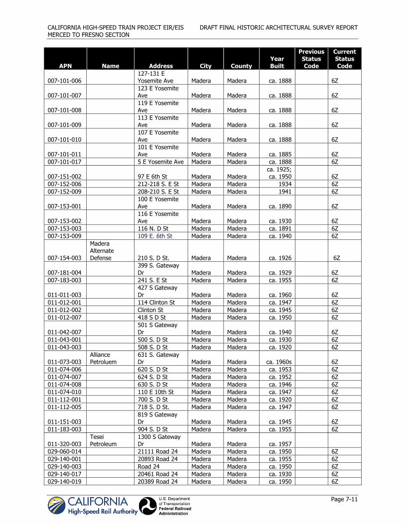
CALIFORNIA HIGH-SPEED TRAIN PROJECT EIR/EIS DRAFT FINAL HISTORIC ARCHITECTURAL SURVEY REPORT MERCED TO FRESNO SECTION
Page 7-11
APN Name Address City County Year Built
Previous Status Code
Current Status Code
007-101-006 127-131 E Yosemite Ave Madera Madera ca. 1888 6Z
007-101-007 123 E Yosemite Ave Madera Madera ca. 1888 6Z
007-101-008 119 E Yosemite Ave Madera Madera ca. 1888 6Z
007-101-009 113 E Yosemite Ave Madera Madera ca. 1888 6Z
007-101-010 107 E Yosemite Ave Madera Madera ca. 1888 6Z
007-101-011 101 E Yosemite Ave Madera Madera ca. 1885 6Z
007-101-017 5 E Yosemite Ave Madera Madera ca. 1888 6Z
007-151-002 97 E 6th St Madera Madera ca. 1925; ca. 1950 6Z
007-152-006 212-218 S. E St Madera Madera 1934 6Z 007-152-009 208-210 S. E St Madera Madera 1941 6Z
007-153-001 100 E Yosemite Ave Madera Madera ca. 1890 6Z
007-153-002 116 E Yosemite Ave Madera Madera ca. 1930 6Z
007-153-003 116 N. D St Madera Madera ca. 1891 6Z 007-153-009 109 E. 6th St Madera Madera ca. 1940 6Z
007-154-003
Madera Alternate Defense 210 S. D St. Madera Madera ca. 1926 6Z
007-181-004 399 S. Gateway Dr Madera Madera ca. 1929 6Z
007-183-003 241 S. E St Madera Madera ca. 1955 6Z
011-011-003 427 S Gateway Dr Madera Madera ca. 1960 6Z
011-012-001 114 Clinton St Madera Madera ca. 1947 6Z 011-012-002 Clinton St Madera Madera ca. 1945 6Z 011-012-007 418 S D St Madera Madera ca. 1950 6Z
011-042-007 501 S Gateway Dr Madera Madera ca. 1940 6Z
011-043-001 500 S. D St Madera Madera ca. 1930 6Z 011-043-003 508 S. D St Madera Madera ca. 1920 6Z
011-073-003 Alliance Petroluem
631 S. Gateway Dr Madera Madera ca. 1960s 6Z
011-074-006 620 S. D St Madera Madera ca. 1953 6Z 011-074-007 624 S. D St Madera Madera ca. 1952 6Z 011-074-008 630 S. D St Madera Madera ca. 1946 6Z 011-074-010 110 E 10th St Madera Madera ca. 1947 6Z 011-112-001 700 S. D St Madera Madera ca. 1920 6Z 011-112-005 718 S. D St. Madera Madera ca. 1947 6Z
011-151-003 819 S Gateway Dr Madera Madera ca. 1945 6Z
011-183-003 904 S. D St Madera Madera ca. 1955 6Z
011-320-003 Tesei Petroleum
1300 S Gateway Dr Madera Madera ca. 1957
029-060-014 21111 Road 24 Madera Madera ca. 1950 6Z 029-140-001 20893 Road 24 Madera Madera ca. 1955 6Z 029-140-003 Road 24 Madera Madera ca. 1950 6Z 029-140-017 20461 Road 24 Madera Madera ca. 1930 6Z 029-140-019 20389 Road 24 Madera Madera ca. 1950 6Z

CALIFORNIA HIGH-SPEED TRAIN PROJECT EIR/EIS DRAFT FINAL HISTORIC ARCHITECTURAL SURVEY REPORT MERCED TO FRESNO SECTION
Page 7-12
APN Name Address City County Year Built
Previous Status Code
Current Status Code
033-030-003 17880 Road 24 Madera Madera ca. 1955 6Z
033-210-004 Riley's Tavern 1750 N Gateway Dr Madera Madera ca. 1950 6Z
034-170-024 13251 Road 28 Madera Madera ca. 1920 6Z
035-092-012 28719 Avenue 15 3/4 Madera Madera ca. 1960 6Z
037-010-023 27363 Avenue 17 Madera Madera ca. 1927 6Z 037-010-028 27467 Avenue 17 Madera Madera ca. 1930 6Z 037-010-032 27637 Avenue 17 Madera Madera ca. 1957 6Z 037-030-003 27584 Avenue 17 Madera Madera ca. 1940 6Z
038-050-001 16449 Sharon Blvd Madera Madera
ca. 1940; ca. 1915 6Z
038-050-003 Madera Madera ca. 1923 6Z 038-122-006 1615 Cardwell St Madera Madera ca. 1950 6Z 038-122-008 Cardwell St Madera Madera ca. 1940 6Z 038-122-014 1521 Cardwell St Madera Madera ca. 1930 6Z 047-220-015 29802 Avenue 11 Madera Madera ca. 1955 6Z 047-230-003 30166 Avenue 11 Madera Madera ca. 1950 6Z 047-240-005 31259 Avenue 10 Madera Madera ca. 1950 6Z 048-090-022 Road 32 Madera Madera ca. 1955 6Z 027-071-017 19898 Avenue 24 Madera ca. 1935 6Z 048-090-025 32413 Avenue 8 Madera ca. 1930 6Z
433-06-007 Guerro Doors 3249 N Valentine Ave Fresno Fresno Pre-1961 6Z
449-16-203 1343 W McKinley Ave Fresno Fresno ca. 1954 6Z
449-16-214 1558 N. Weber Ave Fresno Fresno ca. 1953 6Z
449-16-215 1568 N. Weber Ave Fresno Fresno ca. 1954 6Z
449-16-217 1588 N Weber Ave Fresno Fresno ca. 1957 6Z
450-27-212
Main Event Almighty Boxing Club and Belmont Circle Office Center
93 E Belmont Ave Fresno Fresno ca. 1950 6Z
450-27-227
34 E Belmont Ave 51 and 57 W Belmont Ave Fresno Fresno ca. 1948 6Z
450-27-228
34 E Belmont Ave 51 and 57 W Belmont Ave Fresno Fresno ca. 1948 6Z
458-13-117 327 W Belmont Ave Fresno Fresno ca. 1955 6Z
458-24-039
J.B. Mill Feed Co./Zacky Farms 315 N. H St. Fresno Fresno ca. 1920 6Z
458-25-015
Central Piers Mobile Home & RV Parts
284 and 210 N Thorne Ave Fresno Fresno ca. 1950 6Z
459-02-156 459-02-359
La Tapatia & Hoppy's Headquarters
154 E Belmont Ave Fresno Fresno
ca. 1948; ca. 1950 6Z

CALIFORNIA HIGH-SPEED TRAIN PROJECT EIR/EIS DRAFT FINAL HISTORIC ARCHITECTURAL SURVEY REPORT MERCED TO FRESNO SECTION
Page 7-13
APN Name Address City County Year Built
Previous Status Code
Current Status Code
504-10-401 6987 N Weber Ave Fresno Fresno ca. 1936 6Z
504-10-407 6957 N Weber Ave Fresno Fresno ca. 1948 6Z
504-10-501 6873 N Weber Ave Fresno Fresno ca. 1948 6Z
504-10-504 6843 N Weber Ave Fresno Fresno ca. 1959 6Z
504-10-507 6853 N Weber Ave Fresno Fresno ca. 1955 6Z
504-11-401 7093 N Weber Ave Fresno Fresno 1950 6Z
504-11-404 7075 N Weber Ave Fresno Fresno 1946 6Z
504-11-406 7065 N Weber Ave Fresno Fresno 1955 6Z
504-11-410 7041 N Weber Ave Fresno Fresno 1959 6Z
504-11-412 7025 N Weber Ave Fresno Fresno 1946 6Z
504-14-005 6767 N Weber Ave Fresno Fresno ca. 1930 6Z
504-14-006 6761 N Weber Ave Fresno Fresno ca. 1948 6Z
504-14-007 6755 N Weber Ave Fresno Fresno ca. 1948 6Z
504-14-010 6737 N Weber Ave Fresno Fresno ca. 1938 6Z


CALIFORNIA HIGH-SPEED TRAIN PROJECT EIR/EIS DRAFT FINAL HISTORIC ARCHITECTURAL SURVEY REPORT MERCED TO FRESNO SECTION
Page 8-1
8.0 Findings The historic status of the 400 built environment resources surveyed for this HASR is shown on Table 7-1. The survey population included 177 ineligible properties that were not substantially altered are documented on DPR 523 forms in Appendix C. Built environment resources represented in this HASR also include 223 properties that were substantially altered and recorded with streamlined documentation forms in Appendix D. QIs evaluated all of these resources by applying NRHP and CRHR criteria and in accordance with the California OHP Instructions for Recording Historical Resources (March 1995). None of the built environment resources in the APE that were built in 1961 or after (i.e., were less than 50 years old at the time of survey) appeared to have potential for exceptional significance (NRHP Criteria Consideration G). Resources less than 50 years old were exempt from both intensive survey and streamline documentation requirements. No built environment resources addressed in this HASR required further study to resolve the question of their eligibility.
This HASR was prepared as part of project compliance with applicable sections of NHPA and its implementing regulations issued by the ACHP as these pertain to federally funded undertakings and their impacts on historic properties. This HASR will be submitted to the CASHPO for its concurrence in the adequacy of the APE and the identification and evaluation findings.
All historic-period architectural resources (built in 1960 or before) that did not meet the draft HST Section 106 definition for “streamlined documentation” were also evaluated in accordance with Section 15064.5(a)(2)–(3) of the CEQA Guidelines, using criteria outlined in Section 5024.1 of the California Public Resources Code. None of the historic architectural resources surveyed and presented in this HASR is considered a historical resource for the purposes of CEQA. CEQA historical resources are those listed in the CRHR, eligible for listing in the CRHR, or those that meet other local government standards as historical resources, as per CEQA Guidelines Section 15064.5(a)(4).


CALIFORNIA HIGH-SPEED TRAIN PROJECT EIR/EIS DRAFT FINAL HISTORIC ARCHITECTURAL SURVEY REPORT MERCED TO FRESNO SECTION
Page 9-1
9.0 References Atwater Chamber of Commerce. 2007. History of Atwater, CA. Electronic document,
http://www.atwaterchamberofcommerce.org/history.html. Accessed January 15, 2010.
Baloian, R. 2003. Primary Record: P-10-005721. On file at the California Department of Parks and Recreation (DPR).
California Department of Transportation (Caltrans). Structures Maintenance. 2006. “Historic Bridge Inventory.” http://www.dot.ca.gov/hq/structur/strmaint/historic.htm. Accessed March 2010 and October 2010.
California High Speed Rail Authority and Federal Railroad Administration (Authority and FRA). 2009a. Merced to Fresno Architectural Survey and Evaluation Plan. Sacramento, CA, and Washington, DC. August 2011.
California High Speed Rail Authority and Federal Railroad Administration (Authority and FRA). 2011b. Section 106 Programmatic Agreement among the Federal Railroad Administration, the Advisory Council on Historical Preservation, the California State Historic Preservation Officer, and the California High Speed Rail Authority Regarding Compliance with Section 106 of the National Historic Preservation Act. Sacramento, CA, and Washington, DC. June 2011.
California High-Speed Rail Authority and Federal Railroad Administration (Authority and FRA). 2012c. Historic Property Survey Report, California High-Speed Train Project EIR/EIS, Merced to Fresno Section. Prepared by AECOM. Sacramento, CA, and Washington, DC. February 2012c.
California High-Speed Rail Authority and Federal Railroad Administration (Authority and FRA). 2012d. Archaeological Survey Report, California High-Speed Train Project EIR/EIS, Merced to Fresno Section. Prepared by AECOM. Sacramento, CA, and Washington, DC. February 2012d.
California Office of Historic Preservation (OHP). 1976. California Inventory of Historic Resources. Sacramento, CA: California Department of Parks and Recreation.
California Office of Historic Preservation (OHP). 1992. California Points of Historical Interest. Sacramento, CA: The Resources Agency, California Department of Parks and Recreation.
California Office of Historic Preservation (OHP). [1990] 1995.California Historical Landmarks. Sacramento, CA: The Resources Agency, California Department of Parks and Recreation. http://www.parks.ca.gov/default.asp?page_id=21386.
California Office of Historic Preservation (OHP). 2011. Historic Properties Directory Listing by County, for Merced, Madera, and Fresno Counties (through 9 March 2011). Prepared by the State Office of Historic Preservation. On File at the Central California Information Center and the South San Joaquin Valley Information Center. Accessed June 2011. Sacramento, CA.
California State University, Fresno. 2008. Fast Facts about Fresno State. Electronic document, http://csufresno.edu/ucomm/fastfacts/. Accessed January 15, 2010.
City of Atwater Department of Commerce. 1950. Current Population Reports, Special Census of Atwater, California: February 23, 1950. Series P-28, No. 404. Department of Commerce, Bureau of the Census, Washington, D.C. Available at http://books.google.com/books?id=pQlaJvuaWasC&pg=PT368&dq. Accessed May 14, 2011.
City of Chowchilla. 2005. Chowchilla’s History. Electronic document, http://www.ci.chowchilla.ca.us/city%20facts/history.htm. Accessed January 12, 2010.

CALIFORNIA HIGH-SPEED TRAIN PROJECT EIR/EIS DRAFT FINAL HISTORIC ARCHITECTURAL SURVEY REPORT MERCED TO FRESNO SECTION
Page 9-2
City of Fresno. 2010. Specific Plan. Electronic document, http://www.fresno.gov/Government/DepartmentDirectory/DCR/DowntownRevitalization/planningdesign.htm. Accessed January 15, 2010.
Clark, Pamela J. 2001. A Study of The Altrurian Newspaper and Its Attempt to Establish or Reinforce Community Core Values in the Cooperative Colony Established by the Colorado Cooperative Company at Nucla, Colorado, from 1895 to 1901. Dissertation submitted to the University of Wyoming, Laramie, Wyoming. Also found at: http://www.pairodox.org/pams%20dissertation.doc
Clough, Charles W and William B. Secrest, Jr. 1984. Fresno County, the Pioneer Years: From the Beginnings to 1900. Panorama West Books, Fresno, California.
Clough, Charles W and William B. Secrest, Jr. 1986. Fresno County in the Twentieth Century: From 1900 to the 1980s. Panorama West Books, Fresno, California.
Colton & Co., G.W & C.B. 1876. Map of California to accompany printed agreement of S. O. Houghton as to the rights of the Southern Pacific R.R. Co. of Cal. to government lands under Acts of Congress passed July 27, 1866 and March 3, 1871 made before the committee of the judiciary of the Senate and Ho. of Reps. in May 1876. n.p.
Cook, Sherburne A. 1978. Historical Demography. In California, edited by Robert F. Heizer, pp. 91–98. Handbook of North American Indians, Vol. 8, William G. Sturtevant, general editor, Smithsonian Institution, Washington, D.C.
Disturnell, John 1847. Mapa de los Estados Unidos de Méjico : segun lo organizado y definido por las varias actas del congreso de dicha républica y construido por las mejores autoridades. Revised Ed. J. Disturnell, New York.
Donaldson, Milford Wayne. Letter to Jodi Ketelsen or Rob Rodland, 16 August 2010, On file at the Office of Historic Preservation, Department of Parks and Recreation, Sacramento, California.
DMJM+Harris. 2004. Sacramento to Bakersfield, Cultural Resources Technical Evaluation. In association with Applied Earthworks. Prepared for the California High-Speed Rail Authority and the Federal Railroad Administration for the California High-Speed Train Program EIR/EIS. January 2004.
Durham, David L. 1998. California's Geographic Names: A Gazetteer of Historic and Modern Names of the State. Quill Driver Books.
Elliott, Wallace W 1882. History of Fresno County, California. Wallace W Elliott & Co. Publishers, San Francisco, California. 1973 facsimile ed. Valley Publishers, Fresno, California.
Elsmere Canyon website: http://www.elsmerecanyon.com/tunnelarea/passes/oldroad/oldroad.htm. Accessed July 18, 2011.
Enos, John Summerfield, Commissioner. 1887. Second Biennial Report of the Bureau of Labor Statistics of the State of California for the Years 1885 and 1886. J.D. Young, Superintendent State Printing, Sacramento, California.
Fresno Department of Agriculture. 2008. Agricultural Crop and Livestock Report. Electronic document, http://www.co.fresno.ca.us/uploadedFiles/Departments/Agricultural_Commissioner/PDF/2008%20Crop%20Report%20All.pdf. Accessed January 12, 2010.
Gudde, Erwin G. 1998. California Place Names: The Origin and Etymology of Current Geographical Names. 4th Edition. University of California Press, Berkeley.
Gudde, Erwin G. 2010. California Place Names: The Origin and Etymology of Current Geographical Names. 5th Edition. University of California Press, Berkeley.

CALIFORNIA HIGH-SPEED TRAIN PROJECT EIR/EIS DRAFT FINAL HISTORIC ARCHITECTURAL SURVEY REPORT MERCED TO FRESNO SECTION
Page 9-3
Gunsky, F. R. 1989. Pathfinders of the Sacramento Region: They Were There Before Sutter. Sacramento County Historical Society.
Hall, William H. 1885. Merced Sheet, Detail Irrigation Map. California Department of Engineering.
Heizer, Robert F. 1938. A Folsom-type Point from the Sacramento Valley. Southwest Museum Masterkey.
Hoover, Mildred B., Hero E. Rensch, Ethel G. Rensch, and William N. Abeloe. 1990. Historic Spots in California. 4th ed. Revised by Douglas E. Kyle. Stanford University Press, Palo Alto, California.
Hoover, Mildred B., Douglas Kyle, and Ethel Rensch. 2002. Historic Spots in California. 5th ed. Revised by Douglas Kyle. Stanford University Press, Palo Alto, California.
Hyde, Anne F. 1993. “From Stagecoach to Packard Twin Six: Yosemite and the Changing Face of Tourism, 1880-1930.” Published in Yosemite and Sequoia: A Century of California National Parks. California Historical Society, San Francisco.
Jelinek, Lawrence J. 1979. Harvest Empire: A History of California Agriculture. Boyd & Fraser Publishing Company, San Francisco.
Johnson, Stephen, Gerald Haslam, and Robert Dawson. 1993. The Great Central Valley: California's Heartland. University of California Press, Berkeley.
Kopshever, Jim. 2011. E-mail from Jim Kopshever, Harris-DeJager site property owner, to Peter Valentine, regarding withdrawal of site from consideration for use as an HMF, October 27, 2011.
Madera Agricultural Commissioner. 2008. 2008 Agricultural Crop Report. Electronic document, http://www.madera-county.com/agcommissioner/cropreports/index.html. Accessed January 15, 2010.
Madera County. 2007. County History. Electronic document, http://www.madera-county.com/history/index.html. Accessed January 12, 2010.
Madera County Planning Department. 2011. Fairmead Colony Area Plan. Electronic document: http://www.madera-county.com/rma/archives/uploads/1305645006_Document_upload_fairmeadareaplanmaya2011.pdf. Accessed July 18, 2011.
Merced County Agricultural Commission. 2008. 2008 Annual Report on Agriculture. Electronic document, http://www.co.merced.ca.us/archives/36/Merced%202008%20Agricultural%20Report.pdf. Accessed January 15, 2010.Moratto, Michael J. 1984. California Archaeology. Academic Press, San Diego, California.
Merced County Planning Department. 1983. Le Grand Community Specific Plan. Electronic document, http://www.co.merced.ca.us/pdfs/planning/cplan/completed/legrand/legrand_community_specific_plan.pdf. Accessed July 7, 2011.
Outcalt, John. 1925. History of Merced County California: With A Biographical Review of the Leading Men and Women of the County Who Have Been Identified with Its Growth and Development from the Early Days to the Present, Illustrated Complete in One Volume. Historic Record Company, Los Angeles.
Pacific Municipal Consultants. 2000. City of Atwater General Plan. Sacramento, California. Found at http://www.atwater.org/doc_files/chapter_2__land_use__public.pdf. Accessed May 14, 2011.
Rosenthal, Jeffrey S., Gregory G. White, and Mark Q. Sutton. 2007. The Central Valley: A View from the Catbird’s Seat. In California Prehistory: Colonization, Culture, and Complexity, edited by Terry L. Jones and Kathryn A. Klar. AltaMira Press, Lanham, Maryland.

CALIFORNIA HIGH-SPEED TRAIN PROJECT EIR/EIS DRAFT FINAL HISTORIC ARCHITECTURAL SURVEY REPORT MERCED TO FRESNO SECTION
Page 9-4
Sanborn Fire Insurance Map Company. Misc. Sanborn maps for Cities of Atwater, Merced, Le Grand, Madera, and Fresno. On file at the California State Library. Sacramento, CA.
Schuyler, Robert L. 1978. Indian–Euro-American Interaction: Archaeological Evidence from Non-Indian Sites. In California, edited by Robert F. Heizer, pp. 69–79. Handbook of North American Indians, Vol. 8, William G. Sturtevant, general editor, Smithsonian Institution, Washington, D.C.
Solomon, Brian. 1999. Southern Pacific Railroad. MBI Publishing Company, Osceola, Wisconsin.
Thompson, Thomas H. 1891. Official Historical Atlas map of Fresno County. Thos. H. Thompson, Tulare, California.
U.S. Census Bureau. 1930.
US-Cities. n.d. Atwater, CA. http://www.us-cities.org/city/California/Atwater.html. Accessed May 14, 2011.
Wallace, William J. 1978. Southern Valley Yokuts. In California, edited by Robert F. Heizer, pp. 448-461. Handbook of North American Indians, Vol. 8, William G. Sturtevant, general editor, Smithsonian Institution, Washington D.C.

CALIFORNIA HIGH-SPEED TRAIN PROJECT EIR/EIS DRAFT FINAL HISTORIC ARCHITECTURAL SURVEY REPORT MERCED TO FRESNO SECTION
Page 10-1
10.0 Preparer Qualifications This study was conducted by or under the supervision of persons who qualify as archaeologists, historians, and/or architectural historians under the Professional Qualification Standards of the U.S. Secretary of the Interior (as defined in 36 CFR Part 61). The following staff meets the standards for “Qualified Investigator” as defined in the PA (see Appendix E).
Mark Bowen, M.A. (Public History, California State University-Sacramento, 2003) is an Architectural Historian with 15 years experience in the fields of cultural resources management. He is a Cultural Resources Specialist and Project Manager on a wide variety of infrastructure, government facilities, and development projects. He has experience preparing cultural resources technical studies in compliance with Caltrans, Federal Highway Administration (FHWA), and FRA requirements for bridge replacement, road widening, highway projects, and rail improvement projects, and he has prepared studies for review by Caltrans staff in districts 1, 2, 3, 4, 5, 6, 9, and 10. Mr. Bowen has provided research, conducted cultural resources surveys, authored technical reports, and written sections of CEQA/NEPA documents pertaining to cultural resources. He assists clients in compliance with Section 106 of the National Historic Preservation Act, consults regularly with the OHP, and develops mitigation for effects to historic resources.
Madeline Bowen, M.A. (History, California State University-San Francisco, 1992) has more than 14 years experience conducting cultural resources inventory and evaluation studies throughout California and has worked with a wide range of clients, including state, local, and federal agencies. She currently serves as author and co-author of cultural resources technical reports, including historic resources and historic architectural inventories/evaluations. She has evaluated hundreds of resources for significance for the California Register of Historical Resources and National Register of Historic Places, prepared Historic American Building Survey (HABS) and Historic American Engineering Record (HAER) documentation, developed integrated cultural resource management plans, developed mitigation measures, and prepared reports for cultural resource and environmental compliance. Ms. Bowen has conducted research at various sources of primary and secondary documentation repositories throughout California. She meets the Secretary of the Interior’s standards for work in history and architectural history.
Patricia E. Ambacher, M.A. (History, California State University-Sacramento, 2003) is a qualified historian and architectural historian under the United States Secretary of the Interior’s Professional Qualification Standards (as defined in 36 CFR Part 61). In her 8 years experience she has served as the lead historian responsible for cultural resources investigations in compliance with Section 106 of the NHPA for various agencies. Ms. Ambacher prepares a variety of technical reports including HPSR/HRERs, HABS, HALS, FOEs, HPTPs, Initial Studies, and EIRs. She is well-versed in CEQA and has surveyed and evaluated properties in accordance with Section 15064.5(a)(2)-(3) of the CEQA Guidelines for a variety of public agencies. She also conducts archival and historic research to establish appropriate historic contexts for the evaluations of a multitude of property types. Prior to working in the private sector Ms. Ambacher worked as a historian for the California Office of Historic Preservation and served as staff to the State Historical Resources Commission. She has given training sessions to California State Parks’ cultural staff and presented at workshops and conferences concerning multiple property submissions and how to evaluate resources for the National Register and the California Register. Ms. Ambacher is also a contributor to the national Veteran’s History Project of the American Folklife Center at the Library of Congress.
Susan Lassell, M.A. (Historic Preservation Planning, Cornell University, 1994) provides historic preservation and environmental compliance expertise to clients throughout the western United States. With over 17 years experience, Ms. Lassell has been recognized for her ability to smoothly navigate projects through compliance with state and federal environmental laws, including NEPA, Section 106, Section 4(f) and CEQA. Ms. Lassell has conducted a wide variety of historic preservation projects, including built environment survey and evaluation reports, cultural resources management plans, HABS/HAER documentation, master plans for historic sites, and environmental education. Through a

CALIFORNIA HIGH-SPEED TRAIN PROJECT EIR/EIS DRAFT FINAL HISTORIC ARCHITECTURAL SURVEY REPORT MERCED TO FRESNO SECTION
Page 10-2
combination of experience and her master’s degree in historic preservation planning, Ms. Lassell meets the Secretary of the Interior’s professional qualification standards for architectural history and history.
Alan Tabachnick, M.S. (Historic Preservation Planning, Columbia University, 1986) is a Senior Architectural Historian and has over 25 years of significant national environmental and cultural resource expertise, working on projects across the United States. He has acted as Cultural Resources Task Manager on a variety of transportation and infrastructure projects, including transit, roadways, aviation, and ports. He has authored numerous Section 106 documents, including APEs, Determination of Eligibility Reports, Determination of Effect Reports, as well as agreement documents. He is familiar with the project development and permitting processes associated with NEPA and has written numerous Section 4(f) documents.
Vanessa Zeoli, M.H.P. (Historic Preservation, University of Kentucky, 2007). Ms. Zeoli has 9 years experience in historic preservation and 7 years of experience in cultural resources management throughout the eastern United States. She joined AECOM in July 2010, but previously served as Senior Architectural Historian and Principal Investigator for several firms in the Mid-Atlantic region. As Principal Investigator, she has acted as cultural resource liaison between various clients and local, state, and federal review agencies. Over the past 9 years, Ms. Zeoli has completed various documentation and regulatory compliance projects including Historic Architectural Surveys, HABS Documentation, National Register nominations, Section 106 studies, Historic Tax Credit Applications, and existing condition surveys. She exceeds the qualifications set forth in the Secretary of Interior’s Standards for Architectural Historian (36 CFR Part 61).
M.K. Meiser, M.A. (Historic Preservation Planning, Cornell University) Ms. Meiser is a historic preservation planner and a Secretary of Interior-qualified (36 CFR Part 61) architectural historian and historian with 9 years of experience in surveying, documenting, evaluating, and planning for historic structures, districts, sites, and cultural resources. She has consulted on a variety of CEQA and NEPA projects with clients, architects, engineers, and agency representatives for regulatory review, including Section 106 consultation. She has completed a multitude of cultural resource technical reports and archival documents, including California Department of Transportation Historic Property Survey Report (HPSR) and Historical Resources Evaluation Report (HRER) studies, National Register of Historic Places nominations, Historic Structure Reports, and HABS/HAER. Her experience in historic preservation planning provides a strong understanding of federal, state, and local historic preservation laws. She has a thorough knowledge of the Secretary of the Interior’s Standards for the Treatment of Historic Properties and their functions in historic preservation planning. Ms. Meiser maintains a solid knowledge of architectural history and building materials conservation and has led seminars on architectural styles, workshops in materials conservation, and preservation design charrettes.
Anne Jennings, M.S. (Historic Preservation, University of Vermont, 2002) Ms. Jennings is an architectural historian with 9 years experience in providing cultural resource management and historic architectural expertise on a variety of projects throughout the United States. She has conducted fieldwork and historic research for historic architectural resources surveys, National Register nominations, preservation plans, and historic structures reports. She has also participated in the preparation of numerous cultural resource documents in compliance with federal, state, and local preservation legislation, including Section 106 of the National Historic Preservation Act (NHPA) reviews, National Environmental Policy Act (NEPA) reports, memoranda of agreement (MOA), Historic American Buildings Survey/Historic American Engineering Record (HABS/HAER) and state-level documentation reports, historic building reuse studies, environmental assessments and impact statements.
Emma Waterloo, M.A. (Historic Preservation Planning, Cornell University, 2010) Ms. Waterloo is a recent graduate of Cornell University’s historic preservation planning Masters program. She has prepared numerous cultural resource documents in compliance with federal, state, and local preservation regulations, including Sections 106 and 110 of the National Historic Preservation Act (NHPA). She has assisted with the preparation of cultural resources surveys, Historic American Buildings Survey (HABS) documentation reports, and state-level documentation reports. She has also assisted with the preparation

CALIFORNIA HIGH-SPEED TRAIN PROJECT EIR/EIS DRAFT FINAL HISTORIC ARCHITECTURAL SURVEY REPORT MERCED TO FRESNO SECTION
Page 10-3
of environmental impact statements (EISs) in compliance with National Environmental Policy Act (NEPA) and other state and local environmental regulations.