dpwh strategic infrastructure programs and policies dpwh presentation final.pdf · dpwh mandate:...
TRANSCRIPT

DPWH STRATEGIC INFRASTRUCTURE PROGRAMS AND POLICIES
SECRETARY MARK A. VILLARDepartment of Public Works and Highways
April 19, 2018
Presented by:
Director CONSTANTE A. LLANES, JR., CESO III
Planning Service
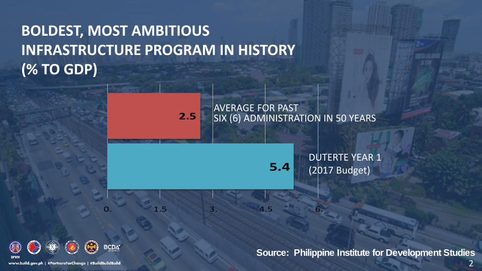
BOLDEST, MOST AMBITIOUSINFRASTRUCTURE PROGRAM IN HISTORY (% TO GDP)
Source: Philippine Institute for Development Studies
2.5
5.4
0. 1.5 3. 4.5 6.
AVERAGE FOR PAST SIX (6) ADMINISTRATION IN 50 YEARS
DUTERTE YEAR 1(2017 Budget)
2
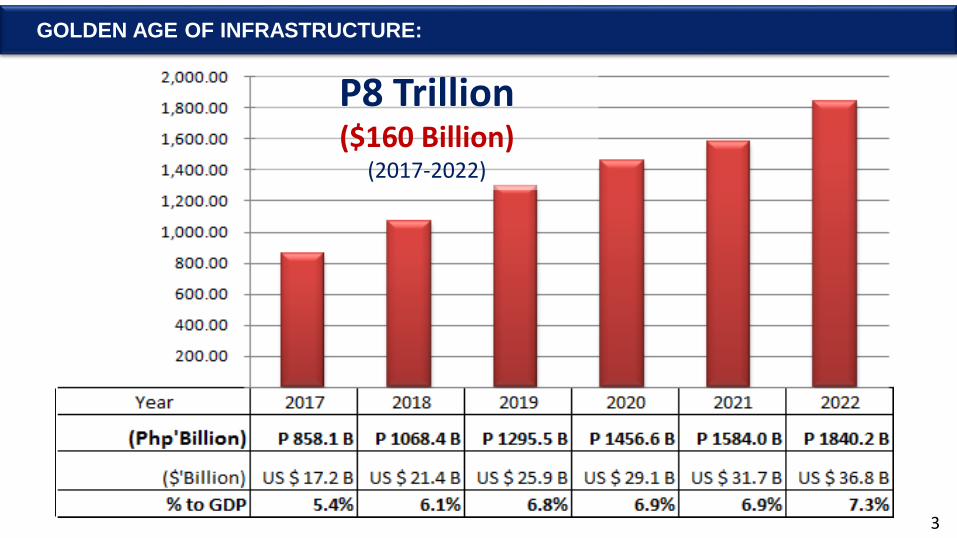
GOLDEN AGE OF INFRASTRUCTURE:
P8 Trillion($160 Billion)
(2017-2022)
3
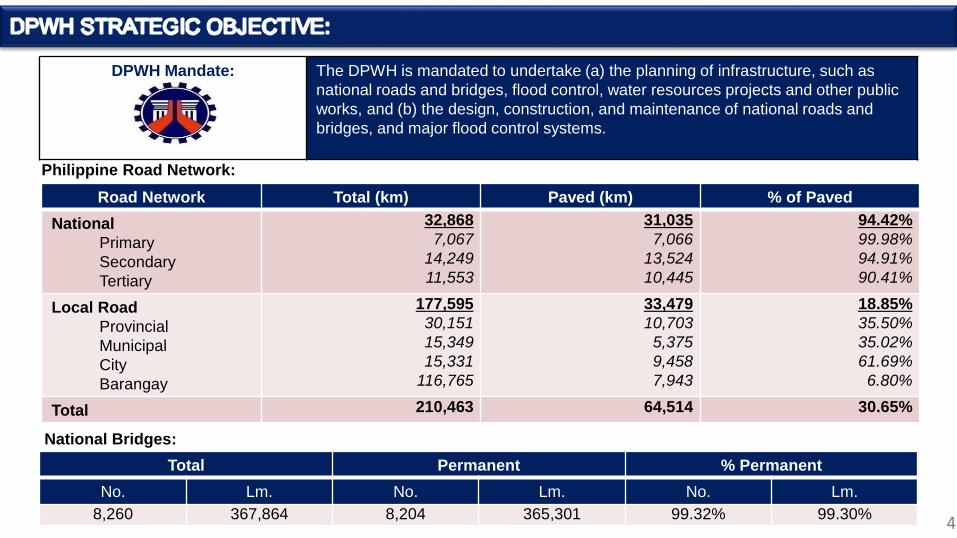
DPWH Mandate: The DPWH is mandated to undertake (a) the planning of infrastructure, such as
national roads and bridges, flood control, water resources projects and other public
works, and (b) the design, construction, and maintenance of national roads and
bridges, and major flood control systems.
Road Network Total (km) Paved (km) % of Paved
National
Primary
Secondary
Tertiary
32,868
7,067
14,249
11,553
31,035
7,066
13,524
10,445
94.42%
99.98%
94.91%
90.41%
Local Road
Provincial
Municipal
City
Barangay
177,595
30,151
15,349
15,331
116,765
33,479
10,703
5,375
9,458
7,943
18.85%
35.50%
35.02%
61.69%
6.80%
Total 210,463 64,514 30.65%
Total Permanent % Permanent
No. Lm. No. Lm. No. Lm.
8,260 367,864 8,204 365,301 99.32% 99.30%
Philippine Road Network:
National Bridges:
4 4
Am
ou
nt
(In
Bill
ion
Pes
os)
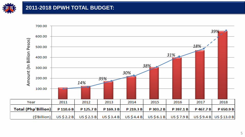
2011-2018 DPWH TOTAL BUDGET:
5
14%
30%
38%
31%
18%
39%
35%

DPWH MAJOR STRATEGIC INFRASTRUCTURE PROGRAM AND POLICIES:
FY 2017 FY 2018
Traffic Decongestion Program(Implement High Standard Highways/Expressways; Construct / widen national roads and bridges; Construct by-passes/diversion roads; Construct flyovers; interchanges and underpasses)
P 113.1 B($2.3B)
P 149.7 B($3.0B)
Integrated and Seamless Transport System(Mindanao Infrastructure Logistics Network, MLIN; Construct/improve roads leading to growth corridors in Western Mindanao; Study and implement Inter-island linkage projects; Connect gaps along national roads; Construct/replace bridges)
P 88.0 B($1.8B)
P 101.5 B($2.0B)
Convergence and Rural Road Development Program(Construct/upgrade local access roads to designated tourism destinations, RORO ports / seaports and airports; Construct/improve roads leading to industrial trade corridors.)
P 18.1 B($0.4B)
P 49.8B($1.0B)
Livable, Sustainable & Resilient CommunitiesIntegrated Water Resources Management Program
(Construct/rehabilitate flood mitigation structures along major river basins and principal rivers; Construct water impounding projects; Construct water supply/septage & sewerage/rain collectors; Upgrade drainage capacity)
Disaster Risk Reduction and Climate Change Adaptation Program(Rehabilitate, retrofit and strengthen existing bridges; Provide safe access to highly vulnerable areas; Improve national roads vulnerable to flooding, landslide and slope failure; Build evacuation centers)
P 106.8 B($2.1B)
P 165.0 B($3.3B)
US $ 1 = Php 506

CAR – P 19.85 B
Region I – P 28.94 B
Region II – P 19.80 B
Region III – P 55.86 B
NORTHERN LUZON – P124.45B (21.75%)
Region XIII – P 31.36 B
Region X – P 55.59 B
Region IX – P 23.09 B
Region XI – P 56.03 B
Region XII – P 23.87 B
MINDANAO – P189.94B (33.19%)
NCR – P42.66B (7.46%)
Region IV-A – P 46.99 B
Region IV-B – P 32.33 B
Region V – P 41.34 B
SOUTHERN LUZON – P120.65B (21.08%)
Region VI – P 31.96 B
Region VII – P 27.66 B
VISAYAS – P94.51B (16.52%)
Region VIII – P 34.90 B
TOTAL : P 572.22 B
* Excludes Inter-Regional/Nationwide-P39.55B7
DPWH 2018 BUDGET BY REGION (CAPITAL OUTLAYS):

Effective Flood Control Program Adopting Integrated Water Resources Management Principles and River Basin Approach
Complete and update the flood control and drainage
master plans and feasibility studies of the 18 Major
River Basins & critical Principal Rivers.
8

STUDY AREA
Cluster City and Municipality
North Danao City, Compostela, Liloan and Consolacion
Central Mandaue City, Cebu City, Talisay City,Lapu-Lapu City and Cordova
South Minglanilla, Naga City, San Fernando and Carcar City
METRO CEBU INTEGRATED FLOOD
CONTROL AND DRAINAGE SYSTEM
MASTER PLAN
ESTIMATED FUNDING REQUIREMENT
River Improvements P 23.9 B
Diversion Channels P 3.5 B
Drainage Mains P 6.1 B
Total: P 33.5 B
IDENTIFIED CASES OF FLOODING
1. Overbanking of Rivers and Creeks
2. Flood Plain/Natural Depression Areas
3. Undersized or absence of Drainage Lines
4. Absence of Outlet

Metro Manila Logistics Improvement ProjectFrom 30 bridges to 42 bridges crossing Pasig River, Marikina River and Manggahan Floodway
BINONDO-INTRAMUROS BR.
NORTH & SOUTH HARBOR BR.
PALANCA-VILLEGAS BR.
BEATA-MANALO BR.
BLUMENTRITT-ANTIPOLO BR.
STA. MONICA-LAWTON BR.
MARIKINA-VISTA REAL BR.
J.P. RIZAL-LOPEZ JAENA BR.
J.P. RIZAL-ST. MARY BR.
MERCURY-EVANGELISTA BR.
EAST BANK-WEST BANK BR. 1
EAST BANK-WEST BANK BR. 2
ESTRELLA-PANTALEON BR.
GUADALUPE BR.
LAMBINGAN BR.
10
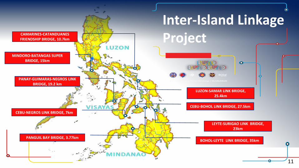
Inter-Island Linkage Project
MINDORO-BATANGAS SUPER BRIDGE, 15km
PANAY-GUIMARAS-NEGROS LINK BRIDGE, 19.2 km
CEBU-NEGROS LINK BRIDGE, 7km
LEYTE-SURIGAO LINK BRIDGE, 23km
BOHOL-LEYTE LINK BRIDGE, 35km
CEBU-BOHOL LINK BRIDGE, 27.5km
CAMARINES-CATANDUANES FRIENDSHIP BRIDGE, 10.7km
LUZON-SAMAR LINK BRIDGE, 25.4km
11
PANGUIL BAY BRIDGE, 3.77km

START: 2018
COMPLETION: 2020
Infrastructure Preparation and Innovation Facility (IPIF)Project Identification and Planning Stage, Feasibility Study, Detailed Engineering Design and Preparation of Procurement Documents of the top priority and infrastructure projects under “Build Build Program”
PROJECT COST:ADB:GOP:
P 3.019 BP 1.416 BP 1.603 B
12
Six (6) Inter-Island Bridges:Luzon-Samar Link Bridge (25.4 km)Cebu-Negros Link Bridge (7 km)Cebu-Bohol Link Bridge (27.5 km)Davao-Samal Link Bridge (4.4 km)Panay-Guimaras-Negros Long Span Bridge(19.2 km)Bataan-Cavite Interlink Bridge (28.0 km)
Tunnel:North Eastern Luzon Expressway (Tunnel Section) -10 km
Road Network:Laguna Lakeshore Road Network Project -90 km
Six (6) Flood Control Projects:Apayao-Abulug River Basin Abra River Basin Jalaur River Basin Buayan-Malungon River Basin Agus River Basin Tagum-Libuganon River Basin
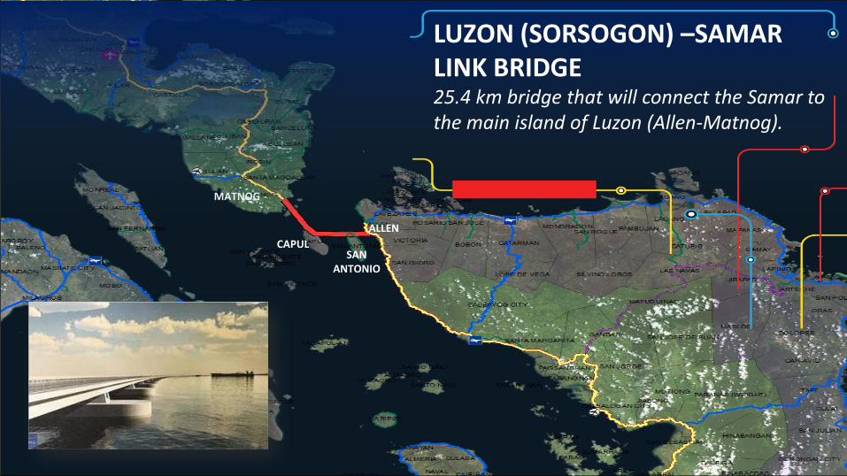
CAPULSAN
ANTONIO
MATNOG
ALLEN
LUZON (SORSOGON) –SAMAR LINK BRIDGE25.4 km bridge that will connect the Samar to the main island of Luzon (Allen-Matnog).

PANAY-GUIMARAS-NEGROS LINK BRIDGE19.2-km Bridge projects linking Panay-Guimaras-Negros Islands
START: 2018
COMPLETION: 2025
INDICATIVE COST:LP:GOP:
P 97.30 B ($1.9B)P 72.98 BP 24.32 B
14

SANTANDER
SAN JOSE
DUMAGUETE CITY
CEBU-NEGROS LINK BRIDGE5 Km Long span bridge with 2 Km Causeway.

CEBU-BOHOL LINK BRIDGE27.5 km Long-span Bridge passing through 3 small islands.
CEBU
BOHOL

Luzon Spine Expressway NetworkFrom 385 km to 1,040 km High Standard Highways in Luzon. La Union to Bicol in 8 hours and 15 minutes.
17

START: 2017
COMPLETION: 2022
NEW BACOLOD ECONOMIC HIGHWAY21.5 km road that would serve as an alternate route passing the interior area of Bacolod City leading to Bacolod Silay Airport and tourists destinations in the area. Will reduce travel time from the boundary of Bacolod City at Brgy Sum-Ag to Bacolod Silay Airport Access Road from 45 minutes to 15 minutes.
PROJECT COST: P 5.79 B ($115.8M)
18

Seg. 1-Talisay-Cebu City-Mandaue: 26.8 km – 6 lanes including 2 km tunnel.
Seg. 2-Consolacion-Liloan-Compostela-Danao: 29.8 km – 4 lanes
Seg. 3-Naga-Minglanilla: 17.2 km – 4 lanes
METRO CEBU EXPRESSWAY 73.8 km high standard arterial road starting from Naga City and ends at Danao City with 2 km tunnel. Travel time between Danao City and Naga City will be reduced from 3 hours to 1 hour and 25 minutes.
START: 2018
COMPLETION: 2022
PROJECT COST:Civil Works:RROW:
P 54.2 BillionP 10.8 BillionP 43.4 Billion

START: 2017
COMPLETION: 2020
U.N. AVENUE UNDERPASS, MANDAUE CITY4-lane (602 m) Underpass with 2-lane service roads at both sides, drainage system, pumping station and an on-grade slab bridge along Plaridel Street. Travel time between Mainland Cebu & Mactan International Airport will be reduced from 1 hour to 40 minutes
PROJ. COST: P 711.82 Million
START: 2016
COMPLETION: 2019
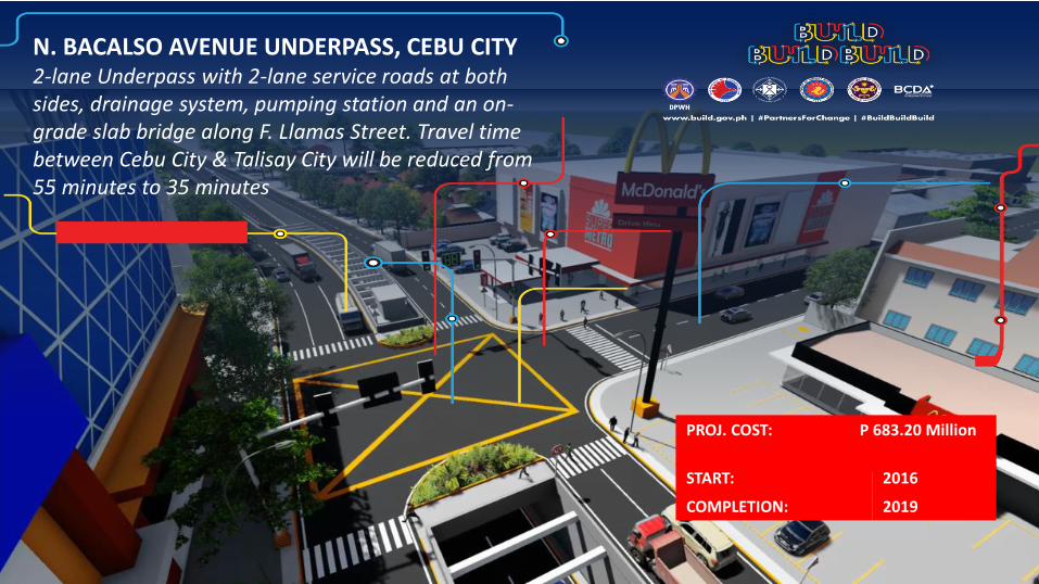
N. BACALSO AVENUE UNDERPASS, CEBU CITY2-lane Underpass with 2-lane service roads at both sides, drainage system, pumping station and an on-grade slab bridge along F. Llamas Street. Travel time between Cebu City & Talisay City will be reduced from 55 minutes to 35 minutes
PROJ. COST: P 683.20 Million

MEASURES TO ACCELERATE INFRASTRUCTURE SPENDING :
22
❖ Created Right-of-way (ROW) task force to address ROW issues in project implementation;❖ Revised the DPWH Right of Way Acquisition Manual (DRAM) pursuant to the new ROW Law, R.A. 10752, to
improve acquisition of ROW;❖ Created Infrastructure Monitoring Advisory Groups (IMAGs) that will enable participatory and transparent
monitoring of big ticket projects;❖ Implemented Project and Contract Management Application (PCMA) for improved efficiency, transparency
and accountability of physical and financial outcomes through use of online geographic based status reporting and geo-tagged photos;
❖ Enforced 24/7 work schedule on major infrastructure projects implemented in urban areas.❖ Issued New Procurement Manual to streamline procurement process; ❖ Created a multi-media citizens feedback mechanism to receive and take action to any complaint, query or
suggestion;❖ Pursued overseas development assistance on complex projects requiring considerable foreign content,
expertise and/or advance engineering technology;❖ Strictly imposed calibrated sanctions/penalties on contractors with negative slippages;❖ Increased level of authority of Regional and District Engineering Offices based on performance and
absorptive capacity.❖ Conducted advance procurement and Detailed Engineering Design (DED) activities for 2018 projects. ❖ Executed MOA with DOE/NEA for the relocation of electrical facilities.

THANK YOU !!!