does geophysics have a role in models? example from ... · test hole airborne data. 34th...
TRANSCRIPT

Does Geophysics have a role in groundwater models? An example from
western Nebraska, USA.
Jared D. Abraham1, James C. Cannia 2 and Steven M. Peterson2
1U.S. Geological Survey, Crustal Geophysics and Geochemistry Science Center, Denver, Colorado, USA, Email
[email protected] ; 2 U.S. Geological Survey, Nebraska Water Science Center, Lincoln, Nebraska, USA

34TH International Geological Congress
Nebraska Panhandle

34TH International Geological Congress
Study Location and Groundwater Models in the Area

34TH International Geological Congress
Appropriated Designations

34TH International Geological Congress
• Main objectives:– Analyze effects of water management options– Study area includes the area within the valley just
downstream of Bridgeport west to ~ 10 km into WY
– Covers the majority of the surface-water irrigated area within the NPNRD
– Analysis goals: determine what kind of management activities provide irrigation season flows (greater than X) past Bridgeport?
Model Background

34TH International Geological Congress
Motivation for Enhancing Hydrogeologic Frameworks
• Traditional techniques (borehole logs, borehole geophysics, surface geophysics soundings, and aquifer tests) produced point data only.
• Point data are interpolated over long distances to create hydrogeologic frameworks.
• Groundwater models lack detail and cannot reliably resolve local variations.
100 km

34TH International Geological Congress
Geology and Lithology
A. Iron stained sedimentsB. Siltstone clasts ~1.5 feet in diameterC. Cross bedded, fluvial, coarse grained
sediments of the Pliocene Broadwater Formation. Manganese stained sedi.
Photo taken ~ 1.5 miles north of Big Springs Nebraska facing west.
A. Tertiary Brule fracturesB. Unfractured Tertiary BrulePhoto taken along summit road between tunnels 1 and 2,
Scottsbluff National Monument, facing east.

34TH International Geological Congress
What AEM Provides to Groundwater Investigations
• AEM surveys provides nearly continuous data that can be calibrated to existing borehole logs and other mutually supportive data.
• AEM data can be quickly collected without disturbing delicate environments (e.g., arctic tundra) and economically important agricultural crops (e.g., corn and wheat).
• AEM data is more economical than ground geophysics over large areas

Resistivity Applied to Sediments
Increase in resistivity
Decrease in resistivityFiner-grained sediment
Coarser-grained sediment

34TH International Geological Congress
Airborne Electromagnetic Survey
SkyTEM Time Domain System Fugro Resolve Frequency Domain System

34TH International Geological Congress
•Translating resistivity to hydrogeologic framework
•USGS OFR 2009‐1110•USGS OFR 2010‐1259•USGS SIR 2011‐5219
Airborne Electromagnetic Surveys

34TH International Geological Congress
Location of Airborne AEM Surveys

34TH International Geological Congress
Block Flights and Reconnaissance Lines
10
100
Canal Data
Test Hole
Airborne Data

34TH International Geological Congress
Interpretation of EM Inversions(displayed as 2‐D Section)

34TH International Geological Congress
Pick Confidence

34TH International Geological Congress
Results of Interpretation

34TH International Geological Congress
Selected Sections from 3‐D Model

34TH International Geological Congress
Change in Saturated ThicknessNew Saturated ThicknessPrevious Saturated Thickness

34TH International Geological Congress
For the area of the airborne geophysical surveys, an additional 458 gigaliters (GL)
(3.7 million acre‐feet)
of water in storage was identified or 34% additional water in storage
~$124 million USD

34TH International Geological Congress
Canal Leakage Potential
• Translation of resistivity to leakage potential
•USGS SIR 2006‐5032•USGS SIR 2009‐5194•USGS SIR 2009‐5223•USGS SIR 2010‐5226

34TH International Geological Congress
Miles of 565 km of data

34TH International Geological Congress
Red
Resistivity Profile of Alliance Canal
Red indicates location of section

34TH International Geological Congress
Canal Leakage Potential

34TH International Geological Congress
Canal Leakage10 km

34TH International Geological Congress
Variations in hydraulic propertiesTertiary OgallalaClay, silt, sand, gravel, Claystone, siltstone,sandstone, conglomerate
Up to 150 meters thick
“The trash can of the Rocky Mountains”

34TH International Geological Congress
NMR Systems

34TH International Geological Congress
Surface NMR Layout

34TH International Geological Congress
Surface NMR Hydraulic Properties
34TH International Geological Congress
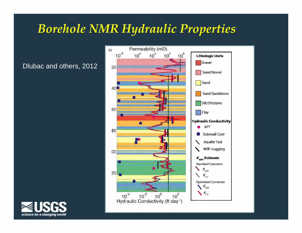
Borehole NMR Hydraulic Properties
Dlubac and others, 2012

34TH International Geological Congress
Borehole and Surface NMR
Knight and others, 2012

34TH International Geological Congress
• Use AEM data to refine aquifer base• Use surface-geophysical data to refine canal leakage
distribution applied to the groundwater flow model• Use NMR to constrain hydraulic conductivity estimates• Use Soil-Water Balance Model to estimate rangeland
recharge• Use latest in Parameter Estimation for calibration• Use latest Ground Water Management (GWM) process
for MODFLOW to perform analysis
Approach‐ Bringing it All Together

34TH International Geological Congress
Changes in Transmissivity
Previous T values New T values

34TH International Geological Congress
Calibration• Groundwater flow model calibration improved when aquifer
base elevations were refined using the airborne data– Mean residual for the North Platte River at Bridgeport was 1,274
l/sec (45 ft3 /sec) less than the model using the previous aquifer base (this is ~10% of the average gaged flow)
– What does this mean?– 1,274 l/sec (45 ft3 /sec) also amounts to 40 Gigaliters
(32,600 acre-ft) per year, or similar to the amount of some of the surface-water irrigation districts in Western NE
– Improvement in overall calibration of simulated: predevelopment steady state water levels and stream base flows as well as transient development period water levels and stream base flows for 1950-2008

34TH International Geological Congress
Flow pathsPrevious Base of Aquifer New Base of Aquifer
1)
2)

34TH International Geological Congress
Green dots: Intentional recharge sites used

34TH International Geological Congress
• Interpretive analysis shows benefit of where to manage pumpage or intentional recharge; and what flows are infeasible
• Model accurately simulates stream base flow with a level of detail not found in previous models of the area
Optimization Model Summary

34TH International Geological Congress
Geophysics HAS a role in groundwater models
• Integrate managers and groundwater modelers at the beginning
• AEM is useful for improving frameworks• Capacitively Coupled Resistivity provides leakage
estimates of canals• Incorporating NMR with AEM improves the distribution of
hydraulic properties • The geophysics provides a representation of the natural
system not achievable by other methods• These improved models allows for greater confidence
because the assumptions in model calibration are validated by observations

34TH International Geological Congress
Project Sponsors

34TH International Geological Congress
Thank You Thank You
Jared D. Abraham (303) 236-1318e-mail: [email protected]
USGS Crustal Geophysics and Geochemistry Science Center (303) 236‐1213Denver Federal Center, Bldg. 20, Box 25046, MS 964, Denver, CO 80225‐0046
http://crustal.usgs.gov/