document resume - eric · document resume ed 250 220 so 015 873. 'author fien, john, ed.; and...
TRANSCRIPT

DOCUMENT RESUME
ED 250 220 SO 015 873.
'AUTHOR Fien, John, Ed.; And OthersTITLE Research in Geographical Education -- Volume 2. Papers
Presented to the National Meeting of the AustralianGeographical Research Association (2nd, Sydney,Australia, December 4-6, 1982),.
INSTITUTION Australian Geographical Educational ResearchAssociation, Brisbane.
REPORT NO ISBN-0-86856-600-4'PUB DATE 83NOTE 278p.; For the prOceedings of the 3.980 national
meeting, see ED 206 554.PUB TYPE Reports - Research/Technical (143)''-- Collected Works
- Conference Proceedings (021)
EDRS PRICE MF01/PC12 Plus Postage.DESCRIPTORS Cognitive Ability; cognitive Development;
Communication (Thought Transfer); ComparativeEducation; Coa.iter Assisted Instruction; CurriculumDevelopment; *Educational Research; EducationalResources; Elementary Secondary Education; *GeographyInstruction; Map Skills; Methods Courses; PreserviceTeacher Education; Slow Learners; Student Attitudes;Teaching Methods; Textbooks
IDENTIFIERS -*Australia; New Zealand
ABSTRACTThis.publication containe 14 papers, most of which
were written by instructors of higher education in Australia andGreat Britain. FollotAng an introduction, the first five papers are"The Development of Children's Map Ability" (Simon,Catling),"Published Guidance to Pupils on..Atlas Mapwork Skills" (HerbertSandford), "Tactual Mapping and the Bold Atlas of Australia" (JohnRoberts), "Students' Ability to TransformVerbal and VisualInformation" (Rod Gerber an4 Nea Stewart -Dore),, "Children Talking toYearn," (Michael Williams). Using microcomputers in geographyeducation is the subject of the sixth paper, "On Sitting Back andLettingen Happen: How to Be Unchained and Use Microcomputers in
Geographical Education (Colin Davey). A case study in preserviceteacher education is presented inpater number seven, "The Armidale'Heritage Study: A Case Study in Applied. Research in Pre-ServiceTeacher Education" (E.S. Elphick and Warren Malloway). The remainingpapers are "Investigating the National Estate: Some Observations froman Implementation Study" (Colin Davey end Anthony Milne), and"Educational Materials and the Corporate Sector: Some IdeologicalImplications" (Jane Williamson), "Bias in Ceography Textbo,As" (Johnrien), "Teaching Geography to Less-Able 11-14 Year Olds" (GrahamCorney and Eleanot"Rawling), "Attitudes and Approaches to TeachingLess Able Pupils ir Year 8 Geography in Queensland" IJohn Fien,Rodney Gerber, and Peter Wilson), "Geography Methods Courses andStudent Morale" (Anne Carter), and "Geography in the New ZealandEducational System and the Process of Curriculum Change" (FrancesSlater). (LP)

4
0NUJ
-I
r.
!rU.S. SIANT/IMPS/ IDUCATION
NATIONAL INSTITUTE OF IDUCATIONFDUCATIONAL RESOURCES INFORMATION
CENTER IERICIThai dot alment hs been reproduced es
myy4 hum the person DI ,gorutiotson
Minot r Ihnuiso, tulvP Won mg& 10 oninaveNati a p,.tI.ty
i'a.,,14 of .w.v yr iatormarts stattai U. OHS 1$(.4.11
tk, not ancess.inly n40031011 tdrtr,71 'of
.11 ixllx y
"PERMISSION TO REPRODUCE THISMATERIAL HA&SEEN GRANTED SY
fje( aiLchr
TO THE EDUCATIONAL RESOURCESINFORMATION CENTER (ERIC),"
Austtaloin Geographical Education Research Association
RESEARCHIN
GEOGRAPHICAL EDUCATION
Volume 2
Edited by
John Fien, Rod Gerber, Kevin Laws and Peter Wilson
ly

I 0
y.
.
Australian Geographipl Education Research Association
RESEARCHI N
GEOGRAPH.I CAL ECiUCAT I ON
VOLUME 2
A collection of the paperspresented to the second national
meeting of the AustralianGeggraphical Research- Association
at the Cambridge Inn, Sydney,
December 4 - 6, 1982
EDITED BY
JOHN F I EN , ROD GERBER; KEVIN LAWS AND PETER WILSON
3

r
ti
r:o
4
Copyright C.1983, AGERA and ,individual authors.
Printed,by Brisbane College of Advanced Education Printery, Brisbane.
ISBN r 04.46-600-411,
Enquiries to:, Australian Geographical Education Research AssociationSocial Studies Department,Brisbane College of Advanced Education,Kelvin Grove Campus,Victoria Park Road,Kelvin Grove,
. Brisbane, Australia. 4059.
Cover Print:
--
The cartoon on the cover was used by John Fien to introduce hispaper on Bias in Geography Textbooks: A Wien
Cover Cartoon and Graphic Works Vivienne Wilson
4

4
o
CONTENTS
Contributors
INTRODUCTION
Page
John Fien, Rodney Gerber, Kevin Laws, Peter Wilson 1
44/. ,
THE DEVELOPMENT OF CHILpREN'S MAP ABILITY
Simon Catling"
PUBLISHED GUIDANCE TO PUPILS ON ATLAS MAPWORK SKILLS
Herbert Sandford 44
TACTUAL MAPPING AND THE BOLD ATLAS OF AUSTRALIA
John Roberts
STUDENTS' ABILITY9TO TRANSFORM VERBAL AND VISUAL INFORMATION
Rod Gerber and Nea Stewart-Dore
CHILDREN TALKING TO LEARN
Michael Williams
ON SITTING BACK AND LETTING IT HAPPEN: HOW TO'BE UNCHAINED
AND USE MICROCOMPUTERS IN GEOGRAPHICAL EDUCATION
3
23
90
) Colin Davey104
0
THE ARMIDALE HERITAGE STUDY : A CASE STUDY IN APPLIED RESEARCH
IN PRE-SERVICE TEACHER EDUCATION
E.S. Elphicisand Warren Halloway118
INVESTIGATING THE NATIONAL ESTATE :eSOME OBSERVATIONS, FROM AN
IMPLEMENTATION STUDY -
4
Colin Davey and Ahthony Milne135
4
EDUCATIONAL MATERIALS AND THE CORPORATE SECTOR : SOME IDEOLOGICAL
IMPLICATIONS
Jane Williamson
154
BIAS IN. GEOGRAPHY TEXTBOOKS :,/k REVIEW1
163
John Fien
TEACHING GEOGRAPHY TO LESS-ABL,t11,14 YEAR OLDS
Graham Corney and Eleanor Rawling185
00.
ATTITUDES AND APPROACHES TO TEACHING LESS ABLE. PUPILS IN YEAR 8
GEOGRAPHY IN QUEENSLAND
John Fien, Rodney Gerber and Peter Wilson.
GEOGRAPHY METHOD COURSES AND STUDENT MORALE' r^
,
Anne Carter ,
. 223
GEOGRAPHY IN THE NEW ZEALAND EDUCATIONAL SYSTEM AND THE PROCESS
OF CURRICULUM CHANGE - SOME TRENDS AND CURRENT PROBLEMS
Frances Slatert.
A
rr ;
,
,
2,
236

r'S
1
MR. STMON CATLING,SOUTHMEAD SUNIO" SCHOOL,.
PRINCES WAY,.
SOUTHFIELDS,LONDON. SW19.
ENGLAND.
SR. ANNE CARTER,McAULEY COLLEGE,GLADSTONE ROAD,DUTTON PARK,
BRISBANE,AUSTRALIA..
CONTRIBUTORS
MR. GRAHAM CORNEY,DEPARTMENT OF EDUCATIONAL STUDIES,
,UNIVERSITY OF OXFORD,
15 NORHAM GARDENS,
Oit'ORD,G0X2GPY,ENGLAND.
DR. COLIN biirEY
DEPARTMENTOF HUMAN AND ENVIRONMENTAL
STUDIES,SYDNEY INSTITUTES OF EDUCATION,P.O. BOX 63,CAMPERDOWN,NEW SOUTH WALES,AUSTRALIA. 2050.
f.
MR. JOHN FINN,BRISBANE COLLSGE OF ADVANCED
EDUCATION,KELVIN GROVE CAMPUS,VICTORI4 PARK ROAD, .
KELVIN GROVE,BRISBANE,AUSTRALIA. 4059.
DR. ROD GERBER,BRISBANE OPLEGE or ADVANCED
EDUCATION,KELVIN" GROVE CAMPUS,
VICTORIA PARK ROAD,KELVIN GROVE4BRISBANE,AUSTRALIA. 4059.
0
MR: WARREN HALLWAY,CENTRE FOR SOCIAL'SCIENCE.EDUCATION,ARMIDALE .COLLEGE OF ADVANCED
tDUCATION,:ARMIDALFAUSTRALIA. 2350.
DR. ANTHONY K. MILNE,DEPARTMENT OF HUMAN' AND'ENVIRONMENTAL
StUDIES, .
SYDNEY INSTITUTE OF EDUCATION
P BOX .63,
CAMPERDOWN,NEW SOUTH WALES,AUSTRALIA. 2050..
'A
MRS. ELEANOR BAWLING,ASSOCIATE DIRECTOR,GEOGRAPHY 16 -19 PROJECT,
INSTITUTE OF EDUCATION,UNIVERSITY OF LONDON,BEDFORD WAY,LONDON: WC1H OAL,
ENGLAND.
MR. JOHN ROBERTS,GEOGRAPHY DEPARIMENT,UNIVERSITY OF SYDNEY,.
SYDNEY, $
AUSTRALIA. 2006:
DR. HERBERT A. SANDFORD,BRUNA PIN,18 BICTON PLACE,LEIGHAM,PLYMOUTH. PLG 8RN,
ENGLAND.'
4
DR. FRANCES SLATER,GEOGRAPHY DEPARTMENT,INSTITUTE OF EDUCATION,UNIVERSITY OP LONDON,
,LONDON. OAL,ENGLAND. ,
4
°No
N.

o
-I
MRS. NEA STEWART -DORE,BRISBANE COLLEGE OF ADVANCED EDUCATION,
KELVIN GROVE CAMPUS 111h
VICTORIA PARK ROAD,KELVIN GROVE, .
BRISBANE,AUSTRALIA. 4059.
MR. MICHAEL WILLIAMS,EDUCATION DEPARTMENTUNIVERSITY OP MANCHESTER,OXFORD RoAp,'MANCHESTER' M13 9PL,ENGLAND.
0
MS. JANE WILLIAMSON"BRISBANE COLLEGE ON ADVANCED EDUCATION,
Kew= GROVE CAMPUS,VICTORIA PARK ROAD,KELVIN GROVE,BRISBANE,AUSTRALIA. 4059.
DR. PETER WILSON,BRISBANE COLLEGE OF ADVANCED EDUCATION,KELVIN GROVE CAMPUS,VICTORIA PARK' ROAD .'AKELVIN GROVE, -
BRISBANEAUSTRALIA.. 4059.
55
0

3..
INTRODUCTION
r search in Geographical Education - Volume
submitted to the second national meeting of
set after the inaugural national meeting 'in
2 is a collection of the papers
AGERA. It follows the precedent
L980. The popularity of this
initial publication enhances our perception,that there is a definiteneed to
disseminate the results of quality. research in geographical education-widely.
As well, the national meetings of AGERA seem to provide a much-needed forum
for people to 'expose the considerable variety of research studies they have
been undertaking throughput the world.
The international flavour'of the initial AGERA publication has been maintained
in this second volume, as has the variety of reported research studies.
,1 Papers included here have emanated from Australia and the United Kingdom.
They have been written mainly by people working in the tertiary education
sector, put who have strong links with primary and secondary schools.
The papers presented here ariiianged into four categories:
0
1. studies in skills and different modes of communication
2. aspects about the use Of resources in geographical education',
3. considerations of the learner in geographical education and
4. curriculum change In geography.
10ti
Studies in skills and modes of pommunication include six papers Which relate
to the four basic modes of communication. ,Three papers deal specifically
with maps. Simon Catling sheds new light on the nature of children's map
ability. His synthesis may lead to the development of a theory of develOp-
ftment of children's mapping ability. Herbert Sandford focuses on mapping
skills which pupils usually develop from atlases. He considers the nature,
extent and usefulness of the guidance on skill development which is ,offered
ro
by selected school atlases. John Roberti'addresses the special case of
maps the visually-handicapped users. He illustrates how an atlas can be
designed espedially.for this group of nap users. Rod Gerber and Nee Stewart-
* Dore link maps with verbal statements in an attempt to examine how children
transform verbal information into visuaygraphic information and vice versa.
The oral mode of communicution is the- main consideration of Michael Williams'
paper. Michael examines the functions of conversations in'geography class-
rooms and suggests alternative roles for talking in geography lessons.
Finally, Colin Davey explores the use of Microcomputers in, the geography
classroom from a personal or experiential viewpoint. Colin suggests a four-
fold process which may enhance the use of microcceputers in the geography

6
2.
classroom..
The section on the use of resources in geography contains four papers. The
first of these details' heritage study:in ale as an example of applieda
research in geography teacher trainees. Warren Halloway and E. Elphick
have used this study to develop a range of skills, knowledge and attitude
aO6ut the Armidals (New)Fouth Wales) built environment which the trainees
can use in their teaching. ,Colin Davey and Anthony Milne present the
results of a study they bonducted on the implementation.of a kit of educa-
tional materials in the National Estate in selected Australian schools.
Their findings should be useful for others preparing curriculum materials
in geogrphy. 'Jane Williamson investigates the production bf educational
resources by the corporate sector. Jane focuses on the materials produced,
by a large multinational mining company in Australia. Finally in this section,
John Fien considers the nature Of bias in geography textbooks. This paper,
although basically a literature review, raises a number bf issues on bias of
which geography teachers should become aware.
The third section considers the learner in geographical education. Two papers
focus on the less-able pupil and one 'considers student morale. Graham Corney
and Eleanor Rawling report on the survey they conductedwith-Anglish less -able
students aged between eleven and fourteen year s-. John Fien, Rod Gerber and
Peter Wilson report on a replication Of this study to Year Eight 'students in
#` Queensland, Australia. Finally, Sister Anne Carter investigates studenth
morale in British geographical education method courses. Anne concludes that
student morale is related to course "aims and level 4 practicality in course
presentation.
There is bnly one paper in the section on curriculum'change in geography. It
is by Frahces Slater, whb examines' the redeielopment of the geography,
curriculum for Forms 5 to 7 in New Zealand. Frances draws a range of pertinent
conclusions about the problems which these changes have pr9duced for
geographical edu8ation in New Zealand.
These papers reflect the commitment of AGERA members 'to improve geographical
education through sensible research activities. Hopefully, they will .
stimulate contributions from other people in the future.
John Fien, Rod Gerber, Kevin Laws, Peter Wilson
to9

4
3.
: THE DEVELOPMENT OF CHILDREN'S MAP ABILITY
Simon Catling*
a.
A16;3tract
aHow realistic are teachers' expectations of childrei's
abilities to read and to draw maps? .A synthesis of
recent ..esearch.into children's development of mapping
ability,. map drawing and map reading skills begins to
answer this qUestion. Such a synthesis reveals-how
important it is, for children to develop an understand-- ing of the elements ,of maps to enable them to employ
the concepts of maps succesealy. Comprehensive
statements on the-desired expectations for the
children's development of map reading and drawing
$ skills should be helpful to teachers planning their's
mapping programmes. ,This synthesis may provide the
1 beginning of a theory of development of childr4n's
mapping ability.
INTRODUCTION
ti
IF a thirteen year old was asked -to draw a map aka classroom as part of an
activity involving planning the,. repositioning pf the main items of furniture.-
or of theway from home to the local shops to help a new neighbour find his
way, what would'we expect her to produce? A likely response is that we would-
wish tp see a map in which the features are accurately located, reflecting
the spatial layout of the aria'as if seen in plan"sspective, whether those
features are drawn in plan-view or are shown byiymbols, these identified in
a key. The features in the map would be accurately shown in proportion, the
'distances between them reflecting tie reduction of scale, which would, perhaps,
be abown by a scale bar. We would also expect the map to satisfy the purpose
for which it was drawn.
The drawing of such a map is an activity which primary, middle and secondary
school children may well, in a variety of guises, be requested to do. It
* Mr. Sim& Catling is Deputy Headmaster at the Southmead Junior School,
London.
rie

4.f
-
may form part of the study of the locality, aimed ateliciting information
for the children about their awareness of the localarea (Stoltman, 1980)4
or it may be an 'introductory or diagnostic element in a mapwork course
(Catling., 1978a). Whichever it be, it is likely that the teacher would hope
that each..child's map drawing would measure up to the expectations stated
above. Likewise, children are often invited to use maps., either actively,
to follow during a trail walk,"r passively, perhaps as part of a maths-
matics textbook scale or grid exeruis3.
If the same child were asked to relate a teacher-drawn map of the classroom.
toAthe features,in that loom, or to describe what is shown th a few grid
squares of a land -use map, whatunderstanding would we anticipate that she
requires in order to undertake either'ofthese teaks? We would generally
expect thatAie be.able to pereeiye and read the symbols on the map, relating
these to the features or concepts which they represent either in reality orr .
"toa generalised mental image, drawing on IgeVioils experience or reflection,
and employing the key. The referencing of a symbol to the correct featuree`
in the environment requires that, the child is able to orientate the map,
whether actually or mentally, and to locate symbols and features in the
spatial field. ..For the child to.apprediate the apitial:form of the mapped
area a similar ability to orientate oneself within the map 14 otsential.
Such aptitudes indicate that the child understands the perspective of the map
as a representation of the landscape, And sees it holistically. Equally, if
the task is well done, it is obvious that she recognizes the purpose of the
map in hand and its limitations, and is aware of the scale of the map and .
can use it accurately.
These stiessments of what we wouldapect of a child's-ability in map drawing
and map reading introduce the three key points of this paper. Firstly,
these examples identify the elements of understanding required to appreciate
and utilize the map concept. Secondly, they are statements which presume
achieved accuracy, understanding and quality of interpretation on the child's
part. Thirdly, achieved capability implies learning founded in structured
experience. The extent to which children may be capable of reaching these I
standards will be examined shortly, but initially it is important to examine'
the key ideas in understanding the -concept Elm. i.
I,- I
/ EXPECTATIONS IN MAPWORK
4
In the introductory statements of expectations of children's map drawing
and reading five aspects of the map conceptvere identified. ,These are the

elemdnts of location and orientation', perspective, scale, symbolism and.'
purpose. Hamare -graphic representations (Robinson & Petchenik, 1976),
structured by the spatial concepts of iodation and orientation; each
feature, or expressed relationship, has a plade, but its position can only
be stated relative to another feature or relationship, or by way of a
superimposed reference grid,(patling, 1978b). Unlike the depth perspeCtive
of a landscape pieture,,a map's! perspective. presents the landscape, or a. .
selection of features or relationships from it, viewed as if looking down.
.
directly from above, showing the horizontal spatial formin two dimensions.
The map provides a ..iniaturised vie*/ 9f the region portraved,perhaps
Proportionally accurate Or'overtly able to be used for distance or area .
measurements it is a scaled representation. What is included in the map is.
shown, not.by the plan-view that is observed in a vertical aerial 'photograph
but..by a symbol, perhaps plan-shape, pictorial or purely Abstract, which
Oiveh significance to what is shbwn. Naturally, it is not'possible to show
All the features of an area oz -any Map of it, Ifor 'this :Would create
s
.
unnecessary clutter or 'noise!; and less can be shown as the scale of i map
decreases. Thus a map is nece arily selective in the information it displays.'
Its content is defined by its pu.rpose, which also will guide the nature of
its style of presentation, whether topographical or tbpological, hnd its.
.-
level, of abstraction from the reality it portrays. In simplified form,
Figure 1 summarises the characteristics of these elements of the map.
ELEMENT DEFINITION4
Location and . a. relative position: near to, far from, etc. .
Orientation b. absolute position: by grid reference (A4, 6185,
'let. 62° 31' longt. 49° 26' 10").
c. relative direations left of, straight ahead, etc.
d.' absolute direction: north of, east-south-east of etc.
4e. .viewpoint as 4, from above: plan -forms
f. occupancy of horizontal space; site and area covered.
g. projection: relation of earth-surface to plane paper,
Scale h. relative scale: proportion'
i. absolute scale:. ,measurement from specific scale
perspeCtives
Symbolism
Purpope
..-.Figure 1. THE =TENTS OF THE MAP
j. pictorial symbols drawing of particular feature. .
k. iconic symbol: standardized pictogram (windmill,
tree on 0.5. 1:50,000 map)
1. plan symbol: plan-form of feature
m., abstract symbol: unrelated shape or colour (dot,
4 square, etc.; green, brown,.purple, etc.
n. aim of map:, road map, natural regions of world, etc.
selectivity of content: choice of specifi6,features
or relationships
p. abstraction from reality: showing relationships, etc.
not readily identifiable in other ways.
q. form of map: architect's plan, topological
transformation, etc.
12
O

ty
6.
That it is *portant for children to develop an understanding of
elements of the map in order to be able to employ the'concept map success-
fully is a view widely. held (e.g. Fairgrieve,.1926; Sabaroff, 1963-4; \'
Pattison, 1966-7; Rushdoony, 1968; Garnett, 1965; Alen, I974; Sandford,
1974; Bailey, 1974;' Bentley et al., 1975p Axnheim, 1976). From their
earliest, encounters with maps children are exploring these map elements to
a greater or lesieiextent, though sadly often in practice little overt
attention' seems to have been paid to fostering this learning by teachers
(D.E. -S., 1978). Yet the evidence of research (Stringer, 1976) suggests
that experience both of drawing their own and of using prepared maps
will enhance the development of children's map understanding.
In order to =pize such experience, it is essential that account
be taken of the expectations held of Children's map learning. Figure 2
jip presents an outline formulation of'these expectations in terms of map
drawing and map reading skills and ideas, structured around the elements
of the map.' The rationale for:these criteria for achieve map understanding
is that they enable both the setting of objectives for mapwork and offer
a structure with'wh4ch to asses research into the development of
children's map ability. Indeed, if objectives for mapwork are to be
outlined these must take account of the development of children's
understanding.
THE DEVELOPMENT OF MAP ABILITY
In an earlier paper research into children's map ability was reviewed
(Catling, 1979a). A central conclusion was that children's understanding of
the,concept megevolved as they matured. The'review suggested that this
ontological development is both complex and gradual, and that it is related
to the development of children's spatial cognition.
Children's spatial understanding evolves through four stages. The
initial stage, daring the first few months of life, is that of sensori-
motor spatial action, throughout which the child develops a growing,*
awareness of the environment around her. The physical and perCeptual
encounters with the environment which the infant experiences during this
stage, as a result of being moved#around and later of moving herself around,
provide a stream of momentary and haphazard experiences which lay the
foundation for the development of the second stage. 'When the child retvelops
the capacity to represent meptally to herselfan image of even r maw features
and their relative location, she has entered the stage of egocentric spatial
13

O
Figure 2. EXPECTATIONS OF MAP ABILITY
ASPECT KEY IDEAS
Ts
,
0
MAP READING SKILLS AND. IDEAS MAP DRAWING SKILLS AND IDEAS
Location
Orientation
a) Understand that a map snowsthe position of features,and how they stand inrelation to each other.
b) Appreciate that the map hasa frame of reference forindicating position anddirection.'
c) Understand that though' north is generally at the
'top' of a map, it may not
be.
.a) Be able to give or find theposition of a feature relativeto another.
b) Be able to une a grid co-ordinate system (of whicheversort),to find or state position.
c) Remember to check the directionindicator of the map.
d) Be able to follow or giverelative or cardinal. directions
on a map.e) Be able to place a map so that
it is orientated to features orcardinal direcpione in the.
'environment.f) Be able to locate and indicate
the, direction of feature)kinthe environment from the map.
a) Be able to draw places an a mapin accurate relative locationto each other. '
b) Be a*le to or a map with
features in tneir correctlocatlion, as in A scale 14WRemeMber to include in a mapan indication of direction,either of cardinal directionsor of relative directions, suchas of a nearby town.
Scale a) Understand the meaning of
scale: a proportiona...
reduction of reality.b) Appreciate that maps.may
be of different scales.c) Appreciate thetos scale
reduces generalization,
increases.
a) Know that it is important todheck the scale of a map whenusing it.
b) Be able to use the scale on amap.for measuring distance andarea, also for estimating.
c) Be able to compare maps ofdifferent scales, both of thesame and different areas.
a)
b)
c)
d)
Be able to draw a proportion-ally scaled free-hand map.Be able to draw a map to aSpecific scale.Be able to draw maps of differ-ent scales of the same area.Remember to indicate the scaleof the map (or that it is notto scale).
Perspective .a) Appreciate that a map showsperspective from above. ...
b) Understand thatJa map showsthe horizontal space occupied
by a feature.
14
a) Know that large-scale maps show a)
the plan-view form of theenvironment.
b) Know that small-scale mapsschematise the 'view from , b)
Above' of the environment.
Be able to draw'a map of anarea, which shows appreciationof the plan view perspectiveinvolved.Be able to show the spatiallayout of the area.
15
*4

a
ASPECT KEY IDEAS MAP READING SKILLS AND IDEAS MAP DRAWING SKILLS AND IDEAS
Perspective, crRealize that a map is atwo-dimensional represent-ation of a three-dimension-al environment, and thatmany features shown havethree-dimensions iv reality.
d) Appreciate that the 'viewfrom above' enables thespatial ,layout and relation-ships of an area to be shownwhich cannot be readilyindicated in any other way.
e) Understand that the boundednatuTe.of.the,map documentmeans that there arerelationships beyond it thatcannot be shown.
c) Be able to identify features .
from the 'plan-view' position.d) Be able to perceive symbols
where they may Overiay'or beoverlain: to extract 'figure'
from 'ground'.e) Be able to interpret altitude,
Where appropriate, from themap information.
f) Be able to identify the spatialCharacteristics of an area
from the map.
c) Be able to draw a large-scale plan-4o= map of anarea or feature.
d) Be able to draw a schematicmap of an area, indicatingspecific characteristics.
Symbols a) Realise that symbols on amap. represent features,relationthips or general-izations, in the environment.
b) Be aware that symbols showlocation.
c) Appreciate that symbols areclassificatory: indicatingand representing commonproperties of a class of
features.d) Appreciate that as map scale
is reduced symbols becomemore abstract and stylized.
e) Appreciate the difference be-tween. plan-style 'replicative'
symbols of large-scale maps(showing shape, area and
exact location) and abstractor 'representational' symbols
a
a) Be able to use a key.b) Be able to perceive the symbols
on a map, and to grasp both theconcepts and reality behind
them.c) Be able to relate symbols, and
thus features, to each other.d) Be able to extract symbols where
overlain on or by other symbolsand to perceive the feature orrelationship portrayed.
e) Know meaning of bonventionalsigns.
ti
a) Be able to choose approp-riate symbols to representfeatures, i.e., symbols that
have shared meaning.b) Be able to show the relat-
ionships of features byjuxtaposing or embedding
symbols.c) Remember to include a kelt,
with a map drawing. yde'
.;!
17
?).

ASPECT., KRv TDEAS MAP PEADTNa SKTTLS AND IDEAS .MAP DRAWING SKILLS AND IDEAS
Symbols of small -scale maps (showing--position and-general-character -istics of featur4s).
0
t
Purpose a) Appreciate the purpose of themap and the context of its use.
b), Realize that a map merely repre-sents a selection of features,relations and generalizationsAbout the environment, and thatthis derives from the purpose ofthe map.
c) Assess the extent to which themap fulfils the purpose forwhich it was intended.
d) Understand that a map standsfor the real world, but is a'generalization and simplifica-tion of it.
e) Appreciate,the limitatioMs ofthe map( in relation to scale,purpose, size of paper, time ofdraughting, etc. '
f) Appreciate the map as bOth arepresentational and a concept-ual model.
g) Understand that:there are manydifferent. styles of map.
h) Appreciate that map-styledepends on current knowledge,technology and fashion.
i) Realize that the style of themap is related to its purpose.
o
arBe able to find, read- and under-stand the title .
b) Be able to use the map for thepurpose for which it was designed.
c) Be able to extract or retrieveoinformation from the bap viasyMbols.
d) Know when a specific map is or isnot appropriate. ,
q) Be able to explain features,reit:U.6ns or generalizations froma specific map.
f) Bq able\to compare maps ofdifferentscales oepurposes andextract information or explaincircumstances from them.
g) Know for what purpose different° styles of map are used, e.g.
architect's plan drawing, worldmap of Mercator projection, ortopological London undergroundmap.
h) Know when to employ the relevantmap.
i)"Know how to extract information'from .the specific map- style.
j) Know the limits of any particularmap-style:
a) Be able to draw a map that e
includes the necessary,features to fulfil aspecific purpose.
b) Be able to draw maps ofdifferent types of the samearea, to show differentfeatures or characteristics:i.e. maps having differentpurposes.
c) Be able to include thetitle with tat map.
d) Be able to draw maps ofdifferent styles, e.g.scaled plan or topologicaloutline.
e) Know which style of map todraw for which circumstances'or purpose. .
18 19

understanding, in which her swareness of the spatial structure, of the
environment is tied to personal actions, and is characterised by a cognition
Of experience that is centred on her own viewpoint and involvement. During
this stage the child will lea* to move around the home and to certain
'places within its immediate vicinity successfully, as and when she wishes.
However, when asked, she finds it difficultto describe, either verbally.
or graphically, the spatial structure of the area of her movements, in more
than sequential, terms, occur. The continuous experience of familiar
environments, which foster, for example, development of the notions. Of '
direction and relativelocation, leads gradually to a moire co-ordinated
understanding of the spatial layout of the discrete areas she constantly
ides. Achievement.of this awareness indicates that the child has entered
the stage of objective E4atial understanding, and appreciates that spatial
relations between features exist objectively, that is, without tie need to
be described only in terms of her experience of them. Yet the quality of
her understanding is still limited, for although she is aware of the spatial
relaiions within a variety of fimiliar clusters of features, she is not c*
Able to co-ordinate these discrete parts within an holistic frimework.
It is only when she is able.mentally to 'survey' the. whole 'or a territory,
aware of and able to describe its general structure, including reference
N.to 'her areas of ignorance, that the child has entered the fourth, stage of
abstract. spatial understanding,. which, for example, enables hero describe
thelntegrated nature of her familiar environment and to communicate that
understanding fully to others (Catling, 1979b).
.0
a
The range of reported research into map drawing and map reading
Ability (see Catling, 1979a; Stringer, 1976; Meyer, 1973; Spencer &
Darvizeh, 1981; Pichi, 1977) has produced evidence that the child's
understanding of the elements of-the map is initiated as she enters the
qtage of egocentric spatial understanding, but does not achieve fruition
until the stage of al2!;tritspatesrltilinialundan. However, understanding
in one element may move ahead of such development in another; for example,
children seem to be able to comprehend the symbols on a map before they. are
aware of the idea of proportional relat no (Walker, 1978; Charlton, 1975)*,
though they are. unlikely to be able to image a landscape 'from the mesh of
symbols on a topographical map prior to understanding fully the nature of
scale, since the two, with the other map elements, Art 4nextricably inter-
twined in such mental imaging frcm the map:' It would appear from studies
of older children's map drawing and reading that problems of understanding
t.
0
.1 .
persist well into adolescence (Satterly, 1963; Salt, 1966; Pearson,
.1968; Ilsley, 1969; Blair,41964; Lawless, 1974; Boardman, 1975 -6;
Sandford, 1972; Rhys,4972; Heamon, 196; ,Boardman & Towner, 1979, 1980).
An analysis of the research. referred to above reveals the evolution' .
of children's understanding presented in figures 3 and 4. The development
of map drawfhg ability (figures 3) is described separately from tie develop-
ment,of map readingability.(figure 4), both for clarity of itesentation,,
and because map drawing demonstrates a different aspect of map ability front
'map reading. Whereas the latter requires the child to comprehend the
meaning of and demonstrateskills inusing a prepared map, the former demands
that the child translate her image of an area, or her findings from area
study, into a map graphic which'can be understobd by others. Map drawing.
involves the child in the act of creating the mep. Map reading requires .
the child either to bring her cognitive map to or to construct her own image
from the map, depending on her knowledge of and recognit4.on of the area
shwon (Dale, 1971). Through experience of both aspects of mapwork the child
learns to appreciate the knowledge and skills involved in map preparation
and map cognition, becoming aware of the limitations inherent in both
asepects of selection and. interpretation (Rdbinson.aPetchenik,.1976).
This.last sentence) of course, is a statement of intent; it is hived that
the child will come to realize the value, potential and limitationspof the
m Concept, and becciie competent at employing it in appropriate.circum--
stances'as need arises. .
Figures a and 4 show that it is no simple matter for a child to
understand the elements of the maialthough the essential Capacity for'
retrieving information from or presenting information through maps,
however simply, is present in early childhood. Ittis obvious from the
range of understanding and the nature of its development that to become
what might be called map graphicate (Balchin, 1972; Boardman, 1975-6)
involves the interrelated mastery of a wide variety of concepts and skills.
Figure 5, presents.a generalized summary of the child's development, showingti
the relationship of spatial understanding to environmental cognition
(Moare,,1976), drawing ability (Goodnow, 1977; Butterworth, 1977) and
the eleients of map ability.
A notit-of caution in interpreting these figures must be appended
here. The outlines.of children's map ability development presented in
figures 3, 4 and S i'S,schematic and essentially notional. The range of

Figure 3. DEVELOPMENT OF THE CHILD'S MAP DRAWING
two
ASPECT EGOCENTRIC SPATIAL UNDERSTANDING OBJECTIVE SPATIAL UNDERSTANDING ABSTRACT SPATIAL UNDERSTANDING
Location Poor locational awareness: .-
& egocentric of reference
Orientation
Topological connections:connectedness, sequence, order
Sequential style of construc-tion: concern with simplerelations.
Map drawing could not be usedfor navigation in the areait depicts.
Development of object frame ofreference.
Projective relatione:sequential structuring,partially co-ordinated, somedistortion of location andrelations though.
Tendency to cluster groups of°features distinctly from eachother: better structured thanlinks between them.
Sequential style,with branchingpattern,' linking to known area
Improving accuracy: partialvalue in orientation in areashown.
Abstractly co-ordinated frameof reference used in mapdrawing.
Metric structure: 'geometricpattern, integrated whole,
Survey-style, construction:. aware of relations of parts
of area.
Accurate positioning of feat-
ures: map drawing could be
used for orientation in thearea.
Scale No real understanding of scale.
Features are smaller thanreality because of paper.
Size emphasis on 'own'features, e.g. home.
Distance unconsidered, justseparation.
Idea of relative scale developing.
Difficulty in drawing to scale.
Still tendency to emphasise'favoured' places.
Idea of proportion developing.
. Some distance xelationships .being indicated: tendency toover-estimate immediatedistance, and under-estimatelonger distances.
Tendency to squeeze featuresonto, edge of paper, even ifknown to be further awa
Appreciates concept of scale.
Can draw to scale includes
scale line.
PrOportional sizes offeatures roughly accurate.
Proportional distances roughlyaccurate.
Aware of limitation of paper,stops when not room ratherthan squeeze features ontopaper.
3

0 t
J c.
ASPECT EGOCENTRIC SPATIAL UNDERSTANDING OBJECTIVE SPATIAL UNDERSTANDING ABSTRACT SPATIAL UNDERSTANDING
Perspective Elevation/perspeCti e:of hidden 'dead
d
unaware
s
A
Begins to distinguish 450'and90° viewpoints:. attempts touse understanding, but oft9nproduces both on same mae.
Plan-view. peispective: aware
that felkorp occupies hori-zontal space, and that mapshows all ground.
Little.awareness or 'map idea:aware of connecti ns, but
oilittle idea of h"- .to show
them: attempts p cture-styleai solution.
Situation' viewed own
viewpoint: egocentric..
11,
Becoming aware of map as meansof showing relations thatcannot be shown in other ways.
I.
Developing awareness ofrelationships beyond egO-'centric connections.
Aware of map as showingspatial structure and rela-tionships of environment:uses understanding correctly.
Objective 4vieura space:co-ordinates perspectives.
.9
Possible recognition ofproblem Of showing height:developing solutions.
1 Symbols. Pictorial, individualizeddrawingq of features: little
.recognition of need for
public sharing of meaning.
Starts to develop equivalents(or representations) to' show
features.
Recognition of need to shareand communicate with symbols.
Stylized, iconic symbols:possible use of key.
Idea of similarity developing.
Modification of conventional
(or old) 'eqvivalents torepresent. features and spatial
rerationships./
Aware of symbols as mode ofcommunication and as source
of information.
Plan-view representation.Introduction of abstract
symbols.Use of standardized symbols.Recognition of need for key.
Development of new equiva-lents to represent featuresand spatial structure.
- 24 4
25
O

ASPECT
0ErpOlie
a
'EGOCENTRIC SPATIAL UNDERSTANDING' OB44CTIVE SPATIAL UNDERSTANDING
Attempts to provide necessaryinformation in map, but problemof uncertainty about content:in lined, to be unselective of
'who e content.
Tendency eithee.to includu albthat is known-reqardie'ss'Ofv4ue, or to. be arbitrary. or ,
sparing in content toApoint oflittle value. t.
ABSTRACT SPATIAL UNDERSTANDING
Able to decide what should andshould not be included andhow it is best shown:produces useful map thatsuits purpose intended.
Map Drawing Producticeof a 'pictorialdrawing of an area.
No use of paper as frameworkfor map.
Tendency to use parts of paperonly: large empty spaCes.
,PeatUree excluded if placement;impeded by others Alreadydrawn.
4
Tendency to'employ an'orthar.
4 ,graphic projection indrawings.
Production of a schematicdrawing of an area.
bee, initially withoutliiffer-entiating, of paper e&., .e as
framework for map..
Tendency to cover paper, butspaces unconnected'withcontent.
Distortion of placement offeatures Occurs as means ofsolving problem. of impedi-
ment of previously drawnfeatures.
Recognition of problem ofrepresenting 3-dimensionalenvironment in two dimensions:attempts at soltition.
Attempt to introduce depth:Oblique projection (yet doesnot display what is known).
Production of a map-styledrawing of an area.
Constructs own borders for
'1114p .
'All of paper used in a
rational way: spaces have
meaning. .
Idea of'embeddedness ofsy0ols develops: overlaps .
or overlays symbols wherenecessary.
Solution of problem of two -
dimensional representationof three-dimensionalenvironmental space.
Co-ordination of spatialrelations successful, anduse of perspective in plan -
view drawings.
26
r.A

0
ASPECT EGOCENTRIC SPATIAL UNDERSTAND/NO OBJECTIVE SPATIAL UNDERSTANDING ABSTRACT SPATIAL UNDERSTANDING`''
Uncertain of map scale related toto real world.
Able to relate map scale toreal world.
Knows to check scale of mapbefore assessing distance,size, etc.
Perspective Difficulty in appreciating mapperspective, but can identify
a few specific features fromnew viewpoint.
Developing appreciation of plan-view perspective - understandingof perspective over a-small area,e.g. map of neighbourhood. ;
Aware that buildings have height-,
but difficulty in understandingmap has depth: how it representsa 3-D environment in two
dimensions--;
Understands plan-view perspec-tive of map.,
Appreciates perspective over
a region: large area.
Can appreciate depth in map,
L.A. shape of landscape.
Symbols , Can identify symbols if,stylized and obvious, notreally in need of a key.
28
Can appreciate plandeform symbols.Appreciates more generalizedsymbols - becomes aware of needfor a key.
Growing awareness that symbolsstand for features: begins to beable to image individualfeatures.
Can relate small number ofsymbols to each othcr.Can appreciate relief represen-tation (better understanding oflayer shading than contourlines):
Begins to relate map of familiararea to personal image of that
area.
Appreciates symbols as gener-alizations and classifications.
Understands value of key, and
uses it.
Can interpret abstract symbols,and relate meaning to real,
world situation.Aware that syMbols can show
telatimiships.
Can understand complex patternof symbols - can extract
embedded shapes.Can interpret relief symbols.
Begins to construct image ofunfamiliar area from map of
it.
29

ABSTRACT EGOCENTRIC SPATIAL UNDERSTANDING OBJECTIVE SPATIAL UNDERSTANDING r ABSTRACT SPATIAL UNDERSTANDING
Purpose Fails to appreciate purpose of aparticular map.
Ur abli to select appropriate map.
Can use map for a specificpurpose.
Uncertain as to appropriatenessof specific map when needs to
make choice.
Map Reading Able to comment on a Simple ,
relationship, e.g. this is
Interpretation my house, that is yours, andthis road loins them, etc.
Looks haphazardly around themaps interested in features(symbols) that catch his eye.
30
Able to derive information frommap, e.g. this route is the oneto follow from A to 71, X farm
is in square L9, etc.
Able to understand and use map
for purpose intended..
-4Mr-arecIf-TriiitatiOUS Of differ-
ent types of maps.Can selett appropriate. map forspecific purpose.
Ihclined to take trips acrossand round the map, possiblylinked up: still tends to bemore interested in detail. .
Attempts to identify patternsbut has problem in explainingthem, e.g. X is a settlementbecause it has a name.
Able to offer simple reasonsand explanations from map, e.g,cannot go across there becausehouses are in the way.
Attempts to relate simpleadditional information to themap, but has difficulty indrawing valid conclusions fromboth: explanations tend to lack
logic.
Able to extract'variety of alt-ernatives from map, e.g. these
' are the routes that could beused, but this is the shortest,
etc.
Able to survey slaves a whole:picks out general Character-'istics of area.
9
ro.
Can identify relationships on amap and draw conclusions fromthem, providing explanations,e.g. X is a settlement becausea) relation of buildings andb) number of buildings, etc.
Able to -offer Complex explana-tions from the map, e.g. theshorter route may take longerto travel than this lenychierroute because the former isover difficult terrain whichthe latter avoids.
Can relate other information tothe map: draws on own experi-ence, uses verbal, numeric orgraphic information - to drawconclusions and provide reasons.
Can derive explanations by andfrom comparison of maps.

4
t.
Figure 4. DEVELOPMENT OF THE CHILD'S MAP READING
ASPECT EGOCENTRIC SPATIAL UNDERSTANDING OBJECTIVE SPATIAL UNDERSTANDING 'ABSTRACT SPATIAL UNDERSTANDING
Location Understands relative location
and orientation: i.e. near to,
Orientation left of, etc. - but hasproblems of left-right-confusion.
Can use simple grid systems,e.g. B6, developing to simplenumber grids, e.g. 4925'
Can use cardinal directions,i.e. N., S., etc. developingto NW., SE., etc.
Difficulty in fc..iowing pre-, Learns to give and follow
determined route on map, but directions over routes and
able to show a route on a map. .sections of a map, and do samewith map in both familiar andunfamiliarienvirOnment.
Develops Capacity to align map -
using compass irections, butcontinuing problems of confus-ing east-west relations (oal,be linked to left-rightconfusion).
Difficulty in aligning map to
environment.
Able to relate specific symbolson map to particular featuresin environment and vice versa.
Learns to relate map featuresto landscape features, and canalign map using landscapefeatures.
Can use a complex grid,,i.e.° 6 figure reference.Develops understanding oflongitude and latitude'gridsystem.
Can understand and use allcompass directions.
Can describe and fo/low'wayaround a map.
advise on likely features. encour*ered in unfamiliar,
4a from the map, in the field.
creciates that cardinalerections are absolute - able
oo align map using all compass
. directions correctly.
Scale
32
No idea of formal scale.
Some idea of proportion, e.g.this building is bigger thanthat, this road is longer.
Develops ability to use asimple scale line to measuredistance.
Developing appreciatiOn of pro-portion, e.g. snaking road,longer than straight road.
Appreciates relative size.Not sure of ratio or relation-ship of different scales.
Understanding of scale:measuring 114 estimating,distance and area.
Can compare different scales.Appreciates ratio.Can compare sizes.
33

AO 4.
0
Figure 5. ELEMENTS IL DEVELOPMENT OF MAP ABILITY (after Moore, 19)N. 8)
El
11
gId..1.0 of (*WI
Ocvelnewint Al Spatial, Under-
otandinq and moOreventatton
1 i
tr.
Abstractlygo-ordineted
NeferencoSystom
floodSystem
ofWarw.
1 -.EgocentricOrientation
IMP
4.1
NAM
1View tramabove withPlan hos
PAP GRAPHICACY
21::freewith
lased.plan rorm
dadelevation
Nepreeentaties
Idea of Ahemwith elegationaspreeontatiam
ffront.es'
View
II
Development of
Oefrence System
AccurateScaling
.A141U0Seale
.... andPropoitions
Seletiveelseend
DistanceDecreasing
fromRase
--Arbitrary
andVariablo
Alsoend
Distanceflepitasiste0
:Sam
I 3
A II
ID
StandardisedAbstract
Symbols
Wes
I
I esvulrmeoremenvettill
of
'Representational' 4
1environmental
IconicOres
I11
hatasesSymbols
UMWPictorial'Alike'
Symbols
I.
11.000Atrieammo Noticing ....
offiletntee
Perspective
II
Drawing
.--- 1II
AttemptsDepth
toOrawine
. A...
orthonsciticid10
11AMMO 1 t
1 - ot,v imp
Pi
Il
Limitations
I
I
Other
I
11
ii
Perceivingppitsis
an:p--
Development of idea of Development of Also of
View from above ScaleDevelopment of Development of Development of Development of Nap Needing
_ LACKINGAWKWAL
35

019.
research from which it has been conitructed is varied in depth, breadth and
quality. Though much' work has been undertaken in the U.K., the U.S.A.,
Australia and elsewhere (see; Satterly, 1963; Rushdooney, 1968: Stringer,
19/' Catling, 1979b; Wilson, Gerber & Tien, 1981); it has generally been
1
sma.4 scale; limited in sample total and cross-section", in the ageLrange
covered, and in the nature and variety of map elements, styles and situations.
Inevitably there,isthe danger of generalization from limited find*ngs.
This occurs in the research; and the structure outlined in figures 3, 4
and 5 cannot be excluded from such a chirge. There must, therefore, be
care taken in reading too, much into the findings which have been synthesized
into the developmental sequences of children's map drawing and map )ending
ability.
CONCLUSION
This review has presented not so much an overview of the research,
evidence as an attempt to deyelop from a wide range of stlidies a coherent
outline o4 the development of children's map ability, drawing together
research into map drawing and.map reading. It is offered as a tentative
step towards the construction of a theory that may help to explain the
development of children's map ability. That such a synthesis of disparate
evidence has limitations has been noted. Yet this growing evidence, though
piecemeal, has continually proVided deeper insights into the nature and
development of children's map ability. It seems. pertinent that what it has
to'offer should be built upon rather than discarded. Thus, the outline of
development presented in figures 3, 4 and 5 should focus our thinking on
the' conclusions of the research to date.' Though it,attepptean explanation
of the evidence, it might equally act as a guiue to future studies.
Considerable gains would accrue from broadly based and detailed studies
which fill in the gaps, and challenge, modify or back up this postulated
structure. Equally, what is proffered may have value for our teaching, if
it enables us to organize the experiences' which are important in the
develqpment of Children's map ability in sequences; which both use and
maximize their level of.awareness and potential for understanding.
Achieving this must be our goal.

20.
REFEIIENCES
Alen, J. Geography for children aged 5 to 13, in Long, M. (ad.), Handbook
for Geography Teachers, Methuen, 13-35.
Arnheim, R. The perception of maps, American Cartographer, Vol, 3, 1976,
5-10.
-Bailey, P. _Eliviaitatsimmax, Ravta & ChFles, 1814.
Balchin, Graphicacy, Geography, Vol. SV;A.912, 185-95.
Bentley, J.C., Charlton, W.A:,Goodenough, R.A., PriceR.R., and Rawoliffe,
J.M. The Use of Maps in Sdhoql, .Blackwell, 1975.
Blair, D. A Practical Study of the.Ability of Some Secondary Children to,
Handlethe Representation of Spattal Relationships: Dip.'Ed.
Didiertation,'LiverpoolUniversity.
Boardman, D. Graphicacy in the curriculumt:Educational Review, Vol. 28,
1975-6., 118-25.
Boardman, D. and Towner, * Reading:Ordnance4urvey Maps,. Some Problems-
of Graphicacy, Tea ping Research Unit,; Department of Curriculum
Rtudies,Birming University, 1979.
Boardman,AD. and Towner, Problems of correlating air photographs with
Ordnance. Survey pa, Teaching Geography, Vol. 6, 1980, 761.
Butterworth, G. (ed.) Child's Representation of the World, Plenum, 1077.
Catling, S.J. Cognitiv mapping'exercises as a primary geographical
experience, Tetiching Geography, Vol. 3, 1978are120-3.
Catling, S.J. ..The elements of the map, Classroom Gearepher, March 1878b,
2-10. /
Catling, S.J. Maps aad cognitive maps: this young child's perception,
Geographx, Vol. 64, $79a, 288-96:7) ..
Catling, S.J. Children'eMaps .Place, paper presented at the International
Conference on Environmenta Psychology at Surrey University, July 19th,
1979b ,1 6
a.
Charlton, I.E. IderstdAStudofPuItandaS'lismScale,
Direction, and Location in the Age-range Eight to Thirteen, M.Phil.
dissertation, Leeds University, 1975.
pale, P.F. Children's reactions to maps and aerial photographs, Area,
Vol. 3, 1971, 170-7..
Department of Edubation and Science. Primary Education in England, H.M.S.O.,
1978.
Fairgrieve, J. Geography,in School, U.L.P., 1926.
Garnett, O. Fundamentals in School Geography, Harrap (3rd ed.), 1965.
Goodnow, J. Children's Drawing, Fontana/Open Books, 1977.
D7
Par
L 'IO
+1'
I

Heamon, A4-;-- Visual Petceotion in Geography: a study of selected aspects
of Hpatia'-Ability; M.Ed. dissertation, Reading-University, 1966.
Ilsley, C.V. An Investigation into the Problems of Testing the Reading of
Medium Scale Ordnance Survey Ma{s as Evidenced by the Performance of
a Sample of Candidates of the Certificate of Secondary Education
Ability Range, M.A.:dissertation, London University, 1969.
Lawless, S.R.: Levels of Reopening in Mapwork shown by School Children in g
Malawi, M.Phil. disertatian, Nottingham University, 1974.
Meyer, J.M.W. Mapkapl Skills Instruction and the Developing Cognitive'
12, 1973, 27-35. .
MbOre, G.T. Theory and research on the development of environmental
knowing, in poore, G.T. and Golledge, R.G. (eds.), Environmental
Knowingewden Hutchinson & Rosi,.1976.
Pattison, W.D. .Territory, Learner and Mapl'Elementary School Journal,.
Vol. 67, 1966-7, 14643.:
Bearson, M. An Investigation into the use of Large and Medium Scalee
(1:200,000 or larger topographical maps and,plans in geography'
teaching in the field of Secondary Education in Britain from 1885
to 1966.141.Phil. dissertation, London University, 1968. -
Piche, D. The Geographical Understanding ofphildren Aged 5 to 8 Years,r
Ph.D. thesis, London University, 1977.
Rhya, W. The development of logical thinking, in Graves, N. (ed.), NeW
Movements in the Study and Teaching of Geography, Temple Saith, 1972.
Robinson, A.H. and Petchenik, B.B. The Nature of Maps, University of
Ch.Spigo Press, 1976:
Rushdoony, M.A. A Child's Ability to teid Maps: Summary of the Research,'
Journal ofGeography,021. 67, 1968, 213-22.
SalSaroff, R. Nap Interpretation in the Primary Grades, Elementary School
Journal, Vol. 64, 1963-4, 59-67.
Salt, C.D.. An Investigation into the ability to interpret contOursand
contour maps in a mixed secondary modern school, Adv. Cert. Ed.
dissertation, Sheffield University, 1966.
Sandford, H. Perceptual Problems in Graves, N. (ed.), 22. cit., 19,2.
Sandford, H. Ordnance Survey Maps, in Long, M. (ed.), op. dit.,"1974.
Satterly, D.J.H. A; Study_ of the skills and concepts involved in Map Drawing
and Ma. keadi st children aged 14+ to 15+ in a Seco
Modern School, Dip. Ed. dissertation, Bristol University, 1963.
Spencer, C. and Darviseh, 21. The case foi developing a cognitive environ-s
mental psychology that does not the abilities of
young children, Journal of Environmental Psychology, Vol. 1, 1961,
1-10. 38
e
0
S.

."'"7"7"-'7-7-7-------. , .
s 22..fir
,
'''.
, ,
.
.
Stoltman, J.P. Mental Maps:. Resources -for'Teaching and Learning,
Teaching Geography Occisi4nal Paper No. 32, 'Geographichl
0
Adsoccation, 1980. .
. ,
Stringer, W.N. Spatial cognition and geoiraphical,education, Geographical
Education, Vol. 2, 1976,.431 -54. .
.Walker, RIJ. An-Investigation into the Development of_Map Using Abilities
in Primary School Children,,M.A dissertation, London University,
1978.
Wilson, .P.', Gerber, R. and Tien, J. leds.) Research in Geographical
o .
Education, Australian Geographical Education itedearch Associatiop,
1981.
4
0
a
0
0 0

a
PUBLISHED GUIDANCE TO PUPILS ON ATLAS MAPWORK SKILLS
Herbert A. Sandford *
Abstract Most school atlases provide the pupil with some guidance in
skills for their use. This may be organised into a distinct introductory
section, or. may permeate through and infludhce the entire compilation,4
4and it may be complemented by a separate workbook or handbook. The .
nature, extent and content of this guidance is examined, and some
possible)inadeguacies are revealed.
F.
TYPOLOGY, AND RELATIONS OF DESK ATLASES
AND Assocutb scmxpOoxs AND HANDBOOKS
The guidance provided directly to pupils for their development of
desk atlas skills needs to be considered in its full .and rather complex
context(Figure1). Of atlases marketed for children, both those sold
through.retail outlets for domestic use and those sold for institutional$44
scholastics use, may contain some guidance. It may be limited to a.
partial key to the symbols, and usually is in the cases of retail (trade)
atlases and of history and bible atlases, though there are some striking
exceptions such as Oeborne's Children's Atlas in its current edition
(Peek 1979). The present Concern is with.predotinatelyigeographical
atlases, whether local, national or global in scope (eg. the Westerman
Grundschulatlas Hessen, List's Regionalatlas Bundesrepublik Deutschland
and Klett's:Alexander Weltatlas respectively), and/among these, with
the desk atlas (working atlas or class atlas) rather than with the
reference atlas that is shelved out of the way.
Existing 'classifications cannot be meanimifully!applied to desk atlases
and associated publications. Saliscev treats Of 'school atlases'.as'a
Whole in his main typology (Saliscev 1967) but Imhof in his breaks them
down into history and geography atlases, and into regional and world
atlases (Imhof 1972) . A more helpful typology is that,of,Curkin who
adds the concept of ''sweck' or purpose, and:thusrecognise Grund -, Mittel -,
and Hochr,-ntlatlas (Corkin 1961, 1974). Otiose after an excellent
summarrof the above and other classifications, puts forward his own
oh
* Dr. Herbert qandford is an Associate Resear8h Fellow and an UNESCO
Consultant IA school atlases.
0
0

ICHATI.21.1
GEOGRAPHY ATLAS SOCIAL A ENV. STUD. ATLAS
LOCAL OR REGIONAL ATLAS
REFERENCE SHELF ATLAS
HISTORY ATLAS RELIGIOUS STUDIES ATLAS OTHER SUBJECT AREAAMi]
!DESK (WORKING) ATLAS$
TEACHER'S REFERENCE ATLAS TEACHER'S DESK'ATLAS
'SCHOOL LIBRARY REF. AT.I CLASSROOM LIBRARY REF. AT
with ractice activities
PUPIL'S INDIV. REF. ATL.
I with content guidance
I
PUPILS' DESK ATLAS
UNATTACHEDATLAS
INSEPARABLE ATLASCUM WORKBOOK
SEPARABLE ATLASAND WORKBOOK
SEPARABLE ATLASWITH W/B A H/B
SEPARABLE ATLASAND HANDBOOK
UNATTACHEDW/B AND/OR H/B
with ractice ac with skills with content guidance with no practice or guidance
SCHOOL LIBRARY REF. BK CLASSROOM LIBRARY REF. BK PUPIL'S INDIV. REF. BK.
PUPILS' REFERENCE Boail
REFERENCE BOOK
MomutidiErin
re. large scale maps
FUMY nThrristiaacqu sltlon
TEACHER'S HANDBOOK
re small soh maps
Icartograp4 sensu latol
4 higure 1. TYPOLOGY OF SCHOOL ATLASES AND ASSOCIATED PUBLICATIONS.(The heavvlisse:indicate the main focus of interest of the accompanv41.4 text. Each box or cell may be subdivided accordingto educational grade or level, and ccording to the language in which it is couched.)
OK
roduction map using'
cartograp y sensu strictol
'PUPILS' WORKBOOK'

e. 5.
expanded typology Mews 1975). Unfortunately, even this does not
include guidanua as a distinguishing characteiistic. Dubut did, but inOM
her important and detailed analysis of 150 pupils' desk atlases she
found substantial guidance in too few for it to form a diagnostic
feature in her typology, not even for her category of 'atlas d'initiation'
or 'first atlas' (Dubut 1982).
The proposed classification (Figure 1) not only innovator shelf and
desk atlases, and teacher's and pupils' atlases, but also divides these
last according to the nature of the guidance rather than school grade.
For present purposes, grade say be considered as an extra" dimension
affecting the whole of the classification, which thereforemay be read
successively at, any, primary, middle and upper school levels, so that
there are lower, middle and upper school atlases. Similarly for pupils'
mapwork books, and for all other 'cells' in the diagram. A further
all-through subdivision would be in respect of the language of the
publication, which has relevance to the rendering of geographical names
in particular.
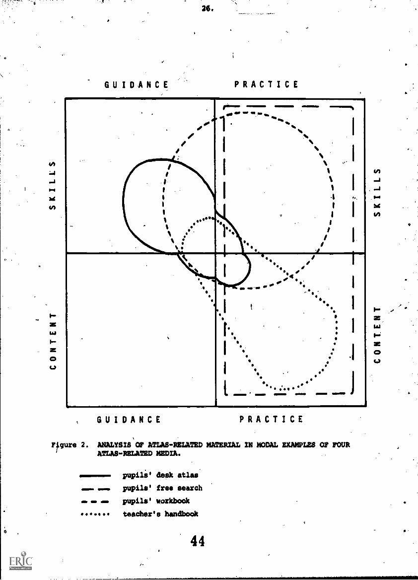
It is important to distinguish between practice and guidance, and between 7
guidance for skills and that for content (Figure 2).' When an atlas
provides an explanation of latitude and longitude, perhaps with a.
1.)worked example or even a singls confirming exercise, it is mapwork
guidance. 'A few atlases however, notably the once \famous Study Atlas
by Workman out of Collins-Longman, set out extensive exercises for the
pupils. Such activity is mapwork practice. Guidance may develop.the
skills with which to manipulate symbols, scales, co-ordinates and
the like, or else may describe, explain and amplify the graphic content
of the atlas. Pupils' atlas workbooks and teachers' atlas handbooks
are both kinds of desk book, but while the former directly guide the
pupils, the. guidance in the latter is mediated through the teacher.
Figure 1 shows that not all desk books relate to specific atlases any
more than do all atlases have a companion desk book, and that some
pupils' workbooks and teacher's handbooks are of no use without the
atlas for which they have been prepared (even though it is possible
for these atlases to be used separately).
0
GUIDANCE
26.
PRACTICE
_.. .
....
..
if
.
iis
..It
1111
I%
%
411.I' 1
.
ie1
'6...mg 4111. gm,
'... 14
I
I
.
s
I
--...%
'lb
likb.. .
. .
,..
II
th
ii
t1
. iI
I0
I
I
I
t..
I
I
.
.
litI%
,
%
a,
0 los.
I 0.d, 0IIM se '.. °P
I
I .
.IS .
I II .
tI
14.*
'
0
..,,,
0
.11 0 e'
''
I
I
p
.1
.4qr.
e
ammomons wow em ammo ammo
GUIDANCE PRACTICE
Figure 2. ANALYSIS OF ATLAS- RELATED MATERIAL IN MODAL EXAMPLES OF FOURATLAS-RELATED MEDIA.
11111111110
IMO
pupili' desk atlas
pupils' free search
pupils' workbook
teacher's handbook
44

It is helpful and necessary to consider the relationship between large
scale (topographic or cadestral) mapwork and small scale (0,rographic
or atlas) mapwork, and between (surveying and) drawing maps and using
them (Figure 3). Atlas mapwork guidance has come to involve a
prolonged preface of largescale mapwork guidance by way of sketch
perception maps, official topographic survey maps, and others. It
reseems legitimate to count this largescale widen in with atlas
guidance per se whenever it occurs in such a co ext. In the present
enquiry the emphasis is upon map using (reading and interpretation)
rather than on map making (drawing and even surveying) though cognizance
is taken of the latter when invoked to aid comprehension and use of
atlas maps. Figures 2 and 3 do not show the complementary and supportive
provision of guidance and practice to serve educational and private
interests that might have been expected. The reasons for this are
obscure.
THE DEFICIENCY IN ATLAS MAPWORK GUIDANCE
Despite the wide range of published works containing guidance for atlas
use there is in toto far less than for large scale maps. This last is
profuse. In her sample of 150 scholastic atlases, Dubut found Only -
ten examples of 'livres du maitre' (teacher's handbOOks or manuals)
and only 15 examples. of 'livrets on pages de traveuxpra,tiquee' (pupils'
workbooks or atlases-contained pages of guidance and/or activities).
Sandford's contemporaneous survey of over 300 similar atlases, though
analysed differently, arrives at essentially the same conclusion
(Sandford 1982).
The relative eparcity of atlas mapwork guidance belies the importance
widely attached it. Indeed, in many parts of the world more teaching
effort is devoted to small than to large scale maps, especially where
official survey sheets are not generally available as in Nigeria and
in the Communist Bloc. Relevant Basic Skills ligurs in the appropriate
Iowa Test (Section N, may reading), and many UK Certificate of Secondary
Education Examinations have questions, even compulsory ones, involving
the practical use of atlases in the examination room. The University
of London has gone further and now publishes a special 'examination
atlas' for use by candidates en courrant and made up out of pages
45

1,4
a
LARGE SCALE
O
2S.
SMALL SCALE
.
.
40
000
.
.#0* ***** #'
4. 444 40 lob40
,40
0tft, 0
.4
.%,
.
... .
.
. %
%N
.
I
.
:
.
. .
..
)II
II
%
%
%
0
r.
I
,,, , 11.
L
.1.
.
4t Vie.
_or...
1
1141I:
4
i
.
I
OINI 11101110 11110110=1.0 amo
LARGE SCALE44
SMALL SCALE
Figure 3. USE AND SCALE RELATIONS IN ATLAS-RELATED MATERIAL IN MODALEXAMPLES OF FOUR ATLAS-RELATED MEDIA.
pupils' desk atlas
pupils' free search
pupils' workbook
teacher's handbook
46

r. 29..
selected from Bartholomew's range of 'environmental:atlases' (Sandford.
1980d)t and another similar examinations board is to follow suit. But
examiners' reports often express dismay at the low leVel of candidates'
attainment in.atlas mapwork. This is not a mere artifact of item
analysis and the application of facility indices during the preparation
of the question papers. 'It is real. The present writer studied the
atlas mapwork of 1600 English secondary school children and concluded
that their low level of attainment is ,not due to low innate ability but
to atlas skills being taken for granted in most teacher training, and
therefore, by'mobt trained teachers (Sandford 1970).
A volunteer group of eleven newly qualified secondary school geography
teachers in England was questioned about a conventional, general-purpose,
hypsometricallyrcoloured, pupils' desk atlas map of China. Not one
could give the height of the surface of Lake Baykal as being between
400 and 600, the lower and upper.limits of the altitude colour surrounding
the lake, and only five of the attempts offered an answer in metnee,
though it.was a metric mapl The position appears to be much the same
in America, for example, where Schneider found similar results among
elementary'schoOl teadherse.more than half of whom could not identify
lines of latitude and longitude (Schneider 1976)1
There seems to be, a fairly wide assumption that.if a child can handle
the large scale map he needs no specific'atlas guidance. In a'survey
of geography teaching in 21 European countries, mapwork figures very
prominently, and atlases were found to be widely distributed, but
atlas mapwork;as such was declared to be significant by only Malta
(Merchant 1971). It is little more than an afterthought in The Use
of Maps in Schools (Bentley 0.a. 1975) and gains only nine lines in
the Schools Council's Understanding Napa (Schools Council 1979). Such
neglect is not confined to Europe. In Nigeria for instance no
reference is made to atlas mapwork skills in the syllabus prepared for
schools by the Institute of Education of Ahmadu Bello University,
Zaria',.and to be used by the present writer in the compilation of
Evans Junior Atlas Junior Atlas for Social Studies (Sandford 1980a).
There is a very real gap that has to'be bridged between large and
small scale mapwork, a gap which could be partly filled by the

30.
.
all-too-l'ttle used International One -in-a- Million map sheets. ,By
virtue of its scale. and of the unfamiliarity and remoteness of what
it depicts, the atlas is necessarily more abstract, more divorced
from reality. The round globe/flat map problem is a severe test of
a girl or boy's conceptual rowers, quite apart from the sheer practical
difficulty of page turning (over and rOund) "and the strain on short
term memory imposed by the impossibility bf placing atlas map, of
adjacent areas side by side as one can-topographic map sheets.
The present wide currency of satellite imagery undoubtedly helps today's
youngsters to understand the-small scale atlas map. But this understanding
is best mediated thrOUgh a globe., The
and some children get -ho nearer to one
or the more, recent Magic Globe that is
globe is now less used in schools%
than the globe pencil sharpenr,
constructed internally And
manipulable in the manner-of Rubik .Cube: (Sandford 1982b) . The. influence..
of the former has been ably written up by Sperling (Sperling 1978) .
THE ORIGINS OF NEGLECT
In the teaching of geography in nineteenth century England, reference
atlas and demonstration globe here of great importance (and wall maps too,
in the board schools) and children were tutored and schooled in their
use Not only would they learn to find the. antipodes of any place, Out
also its perioeci (those living in the same latitude but in opposite
semi-circles of the same meridian) and its antoeci (those living in theet
same semi-circle of the meridian but in opposite parallels of latitude)!
The pupil of that generation could solve problems with atlas or globe
which the teacher today cannot even formulate!
When Scott Haiti* toured Europe for the Royal Geographical Society, and,
brought back to England the ideas of heimatskunde (home knowledge; local
geography) and anschauungslehre (learning by observation; fieldwork),
there dame an enthusiasm for the OrdmanowSurvey map, for the finely \engraved, black-AndWhite, one inch topographic map in sheet.form. Numorous
articles appeared in The Geographical Teacher, later deography, and in
successive Geographical.Association handbooks, to guide teachers in
their use in the classroom. This was established the focus of interest
on the largescale topographic map sheet that persists to this day.
484

31.
Under pressure from full timetables, more time spent on rdnance Survey
maps meant less time for atlases. When cheap pupils' desk atlases
came, the demonstration globe fell into disuse and teachers began to
forget the value of the latter for an understanding of the former.
Cheap milt.' desk globes came much later. Their proper use was
pioneered in'the famous William Ellis School in London, but unfortunately
they never widely 'caught on'.
English pedagogic preferences for mapmrk became widely disseminated
outside Europe, but the relative neglect of the atlas has perhaps been
less marked on the mainland (Sandford & Jacobs 1981) where there has)been
a greater interest from an early date (Peucker 1893).
Syllabuses reflect externally prescribed desiderata involving citizenship,
jobs, the needs of higher education and so forth, while the great
majority of *pile, on leaving school, have quite a different and more
casual approach to the atlas and to other small scale mapb. In England,
for instance, atlases are found in the majority of homes, and both parents
and their children browse through them from time t6 time for interest and
pleasure.
ANALYSIS OF PUPILS' ATLAS MAPWORK
HY FREE AND DIRECT SEARCH
Hoyle studied the voluntary or free search 'of pupils! desk atlas maps by
35 primary school children in England (Moyle 1975), and Sandford similarly
by 340 secondary schodl children (Sandford 1966 (1967)), through an
analysis of their running commentaries. )
Sofia of the more significant details are tabulated in Figures 4,5, and 6.
Figure 4 classifies the children'sinterpretational skills by theme.
These themes are usually single phenomena studied over a large area
(less 'g'-than 'x' according to Hartshorne 1939, 1959), as in international
airwaybnetworks), but may synthesise a =Woe of phenomena in a more
restricted area (leas 'x' than sce as in a classic French study of a ayg).
The alternative to free search is direct search during which children
have to involve themselvei in acti/ities set by the teacher, and the
Figure details this as given in the unattached pupils' atlas workbooks

H
0
Structure
Relief
Drainage
Climate
Vegetation
Occupations
Settlements
Communications
Other
TOTAL
INTERPRETATIONAL, SKILLS.
FREQUENCY' SUCCESS
FREE SEARCH DIRECTED SEARCH. _FREE S. DIRECTED S.
Royle Sandford Moore Prater Sandford Sandford
1975 (%) 1967 ( %) 1973 (0 1975 (%) 1967 (%) 1970 (%)
.,
10 0 0
,...
99.3
12 28 .0 0 . 96.2 39.1
7 0 0 71.8
2422 0 ' 100 79.0
38.82 0 0 53.8
9 0 0 68.0
649 0 0 65.4
44.5
4 0 0 94.8
9 0 0 80.6
lop 100 0 100
Figure 4. ANALYSIS OF PUPILS' ATLAS NAPHORK PRACTICE BY FREE AND DIRECT SEARCH: INTERPRETATIONAL SKILLS.
A
50
51

Using; symbols
Locating places
o. Finding routes
Observing distributions
4 Making comOarlsans
Achieving partial over-
views
Achieving total overviews
TOTAL
/''N\013J/ECTIVAL e
$ K I L L S , N.
EQUENCY SUCCE_SS. 4
FREE SEARCH/ DIRECTED SEARCH . FREE S. DIRECTED S.
Royle1975 (%)
Sandford1966 ,( %)
.,1460re
. 1973 (%) '
Prater1915 (%)
Sandford.1966 % 1967
Sandford1970 (%)
j
/43 t
27 /
t/10'
17
2 :
t
24
35
t
13
19
8.
t
c,
.14
85
1
0
. 0 '
0
0
-
i
,13
76
5
0
5
1
0
98.1-.
98.9
99.61-
A 97.2
99.9.
, 99.4
.99.9 i
.
,l.
' 86.2.
.99.7*
*37.0
39.0
60:6,
...
. 3,8; 5
x 80.1,.
.
.
100 . 100 100 - 100 ,.
.
.
Figure 5. ANALYSIS OF PUPILS' ATLAS MAPNORK PRACTICE BY FREE AND DIRECT SEARCH s OBJECTIVAL SKILLS
* Pupils were provided with a locational overlay
52
t = traceI

4 Map Reading
91,3 Perception
Apperception.
Qualitative techniques
Quantitative techns.
Nap Interpreting
Qualitative interp'n.
Quantitative interp'n
TOTAL
ALL FUNDAMJNTAL SKILL S HIGHER ORDER FUNDAMENTAL SKILLS
F R E Q U E N C Y S U C C E S S FREQUENCY .
FREE SEARCH DIRECTED SEARCH FREE S. DIRECTED'S. FREE SEARCH DIRECTED S.. f_
------,-.K.
Prat",
,19754Boyle
1975 fil
Sandford1966 %(1967)
Moore1973 %
,Prater
1975 %Sandford
1966 %(1967
'Sandford1970 %
Royla1975 %
Sandford1966 % (196'))
Mears1973 %
37
37
16
4
6
0
38
38
15
6
2
0
34
34
31
1
0
0 .
34
34
30
1
1
0
,
98.1
99.0
95.6
98.5
1
168.9
44.2
77.4
76.2
53.4
0
54
20
; 12
141
0
.
0
46
31
18
5
0
1
6
90
3
_______4±1
0
.0', ,
13.
82.
2
0'
100 100 100 100.
100 100 100
F.
Figure 6. ANALYSIS or PUPILS' ATLAS MAPWORK PRACTICE BY FREE AND DIRECT SEAM! s FUNDAMENTAL SKILLS OF MANIPULATING SYMBOLS
55

by Moore (1973) and Prater (1975). These are typical of the genre
and a useful source of information on what teachers want children to be
able to do with atlases. It is seen in the Figure that only very
rarely are these high level interpretational skills required by teachers
altholgh children are interested in making them'And are-quite successful,
especiially when choosing their own.
In order to discuss these topics the child has first to reach intermediate
objectives, to employ such objectival skills as to use map symbols, locate
places, find routes, observe distributions, make comparisons and achieve
partial or more general overviews of the map (Figure 5). These objectives
are listed'in order of increasing apparent difficulty, though, this
appearance is not confirmed by the success rates also given in the Figure.
It is notable that these authors were overwhelmingly interested in the
pupils' ability to locate places (shades of the old, discredited,
'"capes-and-bays' geography?)
Figure 6 analyses the same data in terms of initial, fundamental skills
aployed,their classification having arisen naturally from the study of
the children's own commentaries. Simple map reading is related
directly to what the map symbolises and involves seeing and understanding
these symbols (perception end apperception), and then manipulating them
in either a literary or else in a numerical manner (qualitative and
quantative techniques). For instance, a child might say that "The Indus
is a big river" or that "The Indus is nearly 3000km long". In Sandford's
study tnere were enough techniques emploied for meaningful subdivision.
Qualitative techniques were distributed as\umerosity (numerousness) 12%,
area 13, shape 2 density 1, height and depth "33, 'being part of 3,
'forming a group of 3, length 4, direction 4 position 261 qualitative
techniques as horizontal scale 4%, vertical scale 4 compass 44,
co-ordinates 8 and projection, a trace (one example y). In directed
search there is such variation between authors that it ght be better
to quote the same average figures that are already available* Workman
(1939), Wright (1942), Midgley (1950) and Moore in his first edition
(1961) Sandford 1966 (1967). (In view of these early publication dates
it needs to be stated that there has been little progress made in this
type of publication since then). They give qualitative techniques of area
10%, 'group' 8, length 4, direction 4 and position 70: quantitative
techniques of horizontal scale .27, vertical scale 6,- compass 39 and
56

36.
co- ordinates 28.
Skillsof map interpretation are of higher order than those of map
reading, for they involve deduction ("The Indus floods") and induction
("The longest rivers in India rise in thellimalayas") from the directly
mapped evidence (Sandford 1972). Interpretation may also be either in
words or in numbers, qualitative or quantitative: the railway network
in Russia may be described as being more complete than that in Siberian
Russia or else their indices of connectivily may be compared. Pupils
are already being required to make some quantitative interpretations
but only rarely as yet in respect of atlas maps." Here again teachers
seem to be demanding of pupils less than these pupils are prepared
to offer; many pupils wish to be more precise and to think more widely and
more deeply than is expected of them. This disparity is all the greater
when one considers only the highest order fundamental skills employed in
each manipulation of the mapped symbols (Figure 6). Por instance, a
question requiring the fairly precise location of a particular town
involves seeing and understanding the symbols as well as skill in the
use of the co-ordinates. This last is the highest level skill and so
in the reworked data this alone is counted. It will be seen that in
free search children are very interested in the symbols themselves and
want to go on to manipulate them, often precisely and numerically, and
often =akin, deductive and inductive interpretations, while their teachers
more often take an understanding of symbols.for granted and expect only
the simpler, verbal use of them - simple descriptions of what the map
directly puts into evidence.
The same kinds of pedagogic objectives in regard to mapwork are revealed by
activities in rapwork books compiled for use with a particular, named,
atlas, such as Hawkes' Looking into the Atlas for Wheaton's Middle School
Atlas, or actually bound into the atlas, such as the Study Atlas by
Workman out of Collins- Longman, only recently unavailable after a very
long and successful-run, while comparable objectives outside the United
Kingdom can be found from Canada (in Crime's little School Atlas Maps) to
India (in the Indian Book Depot's very useful and popular, copy -out and
fill-in Practical Geography.)
57
S.Y
GUIDANCE ON ATLAS.MAPWORK SKILLS IN DESK
ATLASES AND ASSOCIATED PUBLICATIONS
For the purpose of analysing skill guidance from the assorted material
it seems valid to acceptnthe overt intention of the author (as revealed
by headings and suchlike) rather than less objectively to attempt to
disinter the unstated and perhaps unconscious objectives. Content guidance
and all practice activities are ignored except for minimal in-context
explanatory worked examples..` Some kinds of guidance were disclosed that
were not equivalent to the kinds of practice classified in Figures 4
4, 5 and 6, and so these form hew categories in Figure 7. This mismatch
is a pure accident arising naturally out of the nature of the samples Chosen:
for analysis as there is logically and in practice a guidance category for
every practice catego.y. In Figure 7 there is sufficient information on
ultimate interpretational skills and on quantitative techniques for these
to be subdivided, but not so for qualitative techniques. There is no
entirely valid means of counting each author's contribution of guidance but
a fairly reliable one is to count pages and this has been done to the nearest
one tenth of significant material.
.Figure 1 shows that skills guidance may be found in an independent or
unattached book (handbook and/or workbook), shared between, atlas and book,
or in a comprehensive atlas cum workbook, and selected examples of each are
analysed. The atlas cum workbook, in which the usual sharp distinction
between the two has broken down, is rare. But it has had a long if sporadic
history as'in the Atlas Geographies published by the now defunct cartographic
house of W and AK Johnston of Edinburgh, a series which contained much
content guidance and skills practice, transparent overlay maps and both
bound-in and loose-insert atlas maps. The -Arrant, widely-used New
Rashistriya Atlas from the Indian Book Depot of Delhi retains this sort of
concept in its combination of atlas map, thoroughgoing content guidance
and more modest skills guidance. The.potettial effectiveness of this kind
of publication is high as is demonstrated by the-attention to objectival
and interpretational skills in the one cited.(Pigure 7).
Most atlas companions are separately bound, however. They are non-obligatory
to users of the atlas but cannot properly be used with any other, and are the
characteristic approach of British publishers to the home market. Fill-in

(or copy-out and fill-in) pupils' desk atlas workbooks are provided
by 84- field and Sims (Checkpoint for Our. World), Oxford University
Press (AFir..1 Atlas Workbook for the Oxford First Atlas) and Collins-
Longman (Atlas One and Two Workbooks for Atlas One and Two), and
permanent ones by Nelson (Atlas 80 and Atlas Scotland Workbooks for
Atlas 80 and Atlas Scotland) and Johnston and Bacon (Clasen)
(Developient Book Land 2 for the World Study Atlas). These are all
largely providers of activities for the pupils.to practice SUMS
they already possess or are expected to learn through the activities,
but the Development Books are atypical in containing much content
guidance and Atlas 80 and Atlas Scotland Workbooks in providing a
measure of skills guidance.
A21 these are for the use of relatively young children, and may he
preceded by the so-called 'pre-atlas' workbook such as tiAt of Collins-
Longman's Let's Make Maps, a useful little' fill-in book. They only
relevance tc the theme of this paper is that their publishers might feel
able to claim that any program-of guidance in or associated with the
atlas itself might beconcertinned. Other such works are sporadically
published', eg. Hammond's pre-:atlas Map Skills Readiness Book, full of
skills guidance for largescale maps.
One of the finest pupils' desk atlas map workbook is Rigby-Philip's
Student's Activity Book (by Lindsay Francis, Colin Green and Tony Milne)
to go with The Australian Atlas, for which the first author was also a
consultant. This was first published in 1978 and was followed in 1981 by
Jacaranda's fine Activity Book (by Rodney Gerber) to go with the
New Jacaranda Atlas. The former provides a fine blend of Ocilla
guidance and practice while the latter finds room for some objective skills
and for much content guidance. This, together with their being
associated with secondary level atlases, set them apart from the great
majority of English examples. Matrom's World Atlas Workbook is a
different type again, providing limited farms of practice only. It is
an exact counterpart-of Hasse's Stordia 1-2 Arbejsblade, companion to'
its Atlas for Folkeskolen.
Superior to even the-exemplary Aus Alian atlas workbooks, or at least
potentially so, are packages that contain not only an atlas but both
59
a pupil's desk workbook and a teacher's desk handbook. The Guide
de Travaux Practigues, for instance, is a fill-in, practice-only
companion to Mon Atlas of Les Editions HRW Ltee. The pupils' material
is actually bound into the handbook but is to be torn out and duplicated.
Meulenhoff Educatief accompanies its secondary grade Schoolatlas mavo/havo
vivo by a booklet of practical questions and activities, and by an
updatable file of content guidance ably edited by Jan Abrahams and
associate. More thorough going are the publications of Biblioteksfbrlaget
in Stockholm. Their OrienteeringsatlaatandStudieatlas are each
accompanied by a very fine pupils' desk workbook (selevhifte) of,
fundamental and interpretational skillk and of content guidance, together
with an even finer teacher's ban kdboo(11Ararhandlednings), both books
being 4avith with their contained atlas map extracts. ,
The finest packages of all are perhaps those published by Tei-koko Sho-in
of Tay.). This family of magnificent elementary, junior high and senior
high school atlases are each accompanied by an even more magnificent
teacher's desk atlas cum handbook ('Shi-do-sho'), made by binding copious
guidance into the atlas, and, at junior high level the atlas, the Chu-gak-ko
Sha-kai-ka Chi-xu, has also a pair of pupils' desk workbooks (IGaku-shu
Haku-chi smus), partly in colour, and" for practice rather than for guidanCe.
From GeographischesVerlagsgesellschaft Velhagen & Klasing and Herman
Schroedel comes a fine family of atlases. The various regional editions
of,their Unsere Welt Grundschulatlis areaccompanied by a small but useful:
teacher's handbook of skills and Content guidance and by a'very fine
map and air photo book with its own fine teacher's handbook of skills and
"content guidance. Pupils can progress through the Unsere Welt aegionalatlas
(of West Germany) to the main Atlas Unsere Welt in various editions and
for which a very competent teacher's handbook is available to offer
guidance in content more than in map skills, and to suggest practice for
pupils.4
Georg Westermann Verlazi also produce a very tine family of atlasesAnd
associated publications of which especial mention ought to be made of
60

their Diercke Weltatlas ( in several editions) ancFits Diercke Handbuch
- perhaps the best such work yet produced and a mime of highly
`authoritative information for teachers, mainly on content but with some
guidance on skills and some suggestions for pupils' practice.. They also.
have a more modest 'lehrerband' for theit'Westerman Weltatlat. There
are other German-language teacher's handbooks cast in\the same mould,
examples being the Lehrermaterialen for the List Gros,rWeltatlas
and for theList Schulatlas, the Lehrerbegleitbuch fok Freytag and Berndt's
Unterstufen Schulatlas, and the Final Report for the Sdweizerischer
Schulatlas of the Interkantonaler Lehrmittelzenttal Kon4eptkomission.1
A .'boswi seri accompanies De kleine Bosatlas, the middle\meMber of the
famous family of Bos atlases of Wolters Noordoorf, and it is worth noting
that Wolters of Groningen was one of the earliest to prodUce an atlas
companion, Bos' Leetboek and his concise or Beknopt Leerbdek der Ardrijkunde
("Textbook" and."Concise Textbook of Geography") for the original Bos'
Schoolatlas de Ceheerde Brae, 1877. Less well known but 'particularly
replete with skills guidance and suggestions for pupil activities is the
.fine little teacher's handbook by John Madden to behused with his
My First Atlas, out of Hammond (Figure 7).a
By far the larger number of pupils' 'desk atlases are accompanied by'no desk
book and it may be useful to select examples' of these that are, in respect
of the current enquiry, more or less representative of Dubut'i types of
atlas, a procedure that is all the more appropriate as guidance was
discarded by her as a diagnostic feature. Duput's 'atlas d'initiation'
or 'first atlas' (herSiroup A) is. intended for young children. When A
wide selection' of these is exaiined it is found that guidance, though
not diagnostic, is frequent, sometimes extensive and generally distidctive
in character. ,Evans Junior Atlas for Social Studies (Sandford 1980a) is
better endowed than most in quantity, quality and balance. It ilusttates
informality in. guidance, with children being helped to learn vicariously
through the portrayed experiences of other children with whom they\can,
identify. Pictures are incorporated and pupils induced t6 learn actively
by the inclusion ef judiciously selected exercises. - \
Dubut's '8' type of desk atlas, her atlas de conception nouvelle, is
characterised by the use of 'paysage' maps (landscape, environmental,
61
%of 41. ,
geoscape or'geographicall, maps (Sandford, 1979) and by bringing together
suites of thematic maps to aid the elucidation of 'polythematic' or general
maps, and frequently by including manycartogrami, diagrams, and such like.
Although cases in this Group do not generally include imich'guidance, it is
needed, and occasionally.provided, as,withBartholomew's very fully guided
First Atlas of the Environment (Sandford, 19S0b).
The third or 'C' the 'atlas classique adominante torogrenhigues or
conventional atlas consisting largely of traditional, hypsametrically-coloured ,
maps - rarely' has much guidance any more than does the 'atlas classique
tisee' of the 'D' Group, wherein the maps are supplemented by much .
thematic material, cartograms and diagrams. Australiancand Polish examples
of these are given.
CONCLUSIONS
Regarding the relationship between atlas, workbook and handbook, it will be
noticed that handbooks are more likely than workbooks or atlases to provide
guidance on interpretational skills, and workbooks more than handbooks or
atlases on objectival skills - and the examples pm Figure 7 are typical of
the difference. It may also be seen that there/is no regularity whereby
the_presence of guidance in a desk book obviates it in an atlas (e.g. the
American My First Atlas denies this) and there may be more duplication than
complementation (e.g. the Swedish Studieatlas, and the Japanese Chu-gak-ko
Sha -Kai -ka Chi -zu).
The total amount o f guidance tends to be greaterin the following cases
(the number of pages being inclusive of atlas and iny associated book) :.
a) When there is a pupils' workbook and/or teacher's handbook as with the
American and Japanese examples cited in the previous paragraph.
b) When there is nou-traditional material as in Bartholamey's First Atlas
of the,Environment.
c) When the publications are of British and Australian, or of German and
Scandinavian origin, such as the New Jacaranda Atlas.
d) When the.atlas is intended for young children, such as Collins-Longmaes
Junior Atlas for New Zealand and the South Pacific.

O
4 3
42.
and which can be compared to their Senior Atlas for New Zealand.
There is no concensus of opinion as to the nature and account of skills
guidance to be provided, or in which kind of publicationlbueit does
seem (despite some excellent examples to the contrary) that guidance
is generally too little and that it is ill-balanced when matched against
either pedagogic or private interests. (Sandford 1980c, 1281a, 1981b)
A more determined effort to bring these into line.is suggested.
REFER arm
Bentley J.C. e.a., 1975,.The Use of Maps in School, London.
Curkin V.G.'1961, GedgrafiSeskie atlasy, Moscow.
Curkin V.G. 1974, Atlasnaja kartografija, Leningrad.
0
Dubut G. 1982, L'Analyse de_150 Atlas scolaires, unpublished report'
to theICA's 11th ICC, available from the author at4
the AFDEC, Paris.
Hartshorne R, 1939, The Nature of Geography, London
Hartshorne R,.1959, Perspective on the Nature of Geography, London
IMhof El *72, Thematische Kartographic, Lehrbuch der Allegemeinen
Geographie, Bd. 10, Berlin.
Merchant E.C. 1971, The'Teaching of Geography at School Level, Educdtion"o
.11LEBELDEAAlstion 2:-"General and Technical Education,
No. 13, London.
Midgley C. 1950, Know Your Was, London.
Moore M.G. 1961, Find the Answer Geography, London
Pask R.F. 1979, (consultant editor for Osborne's Childrens Atlas of the
World, London* .
Peucker K, 1893, (reported in) Geography at the forty-second German
Educational Congress, Geographical Journal 2, 162-164
Prater D.C.R. 1975, Look at Your Atlas, London
Royle D. 1975, The Interpretation of Atlas Maps in the Junior School,
B.Ed. dissertation, University of Exeter, Exeter.
Salacev (Salistsches) A. K. 1967,'EinfUhrung in die Kartographie, Gotha.
Sandford, H.A. 1966 (1967), An Experimental Investigation into Children's
Perception of a School Atlas Map, M.A. (M. Phil.) thesis,
University of London, London.

Sandford B.A. 1970, A Study bf the Concepts involved in the. Reading a1d
itte....tilti2BE121421111LIWIi4MtAtvSsImaJitEktem,
.Ph. D thesis, University of London, London..
Sandford°H.A. 1972, Perdeptual problemi,4n New Movements in the Study and
Teachintkof Geography Graves, Professor N).
4983-92, London.
.Sandford B.A. 1979, Things maps.don't,tell us, Geography 64, p297-302
Sandford H.A. 1980a,(advisor to) Evans Junior Atlas for Social Studies,
London.Sandford H.A. 1980b,(advisor to) Bartholomew's First Atlas of the
..-Environment; Edinburgh.
Sandford H.R. 1980c,Directed and free search of the school atlas map,
Cartographic Journal 17, pp83-92
Sandford B.A. 1980d,(advisor to) Examination Atlas, University of London,
London.
Sandford H.A. 1980e,Map design for children, Bulletin of the Society of
University Cartographers 14, pp39-48.
Sandford H.,4. 1981a,Objective analysis of school' atlases, Research in
Geographical Education, pp234-245, AGERA, Brisbane.
Sandford H.A. 1981b,Towhs on maps, Cartographic Journal 18, pp120-127.
Sapdford H.A. 1982a,A Global Study of Current School Atlases in Relation\
to the School Pupil's Field of Geographical informatiC44:
unpublished report to the s 11th ICC, available from
the author at the College of t.Mark and St.John,
Plymouth.
Sandford H.A.'1982b,Global tensions, The Times Edu ational Su. Inman
30:4.82, p31, London.
Sandford H.A. and Jacobs E, 1981, Cartography'and eacher training: a .
comparison between Britain and The Netherlands, Bulletin
of the Society of University Cartographers 15, pp15-18.
Schneider D.0.1976, the performance of elementary teachers and sudents on
a test of map and globe skills, Journal of Geography
75, pp326-332.
Schools Counci1,1979,Understanding Maps, London.
Sperling W. 1978, Kindliche phantasiegloben, Der Glubusfreund Nr.25-27
pp291-296.
Stams, W.1977, Entwicklungstendenzen der atlaskartographie, Petermans
Geographische Mitteilungen, 121, pp61-70.
Workman B.A.1939, (educational advisor to Collins-Longman's Study Atlas,,
London.
Wright W.D. 1941, Can You Tell Me? London.

TACTUAL MAPPING AND THE "BOLD ATLAS OF AUSTRALIA"
John Roberts*
Abstract
recent cartographic developments have consider dthe possibillity of providing maps for all sortb of.users. Thll.visually handicapped users are onespecial gr p for which maps are being designed.This paper Iconsideres the special/design requirements
It
for tactile maps and details recent developmentsthroughout he worlds Its main/emphasis is to out-line the aOroach and design of the Bad Atlas of
'Australia fbr visually handicapped users. ,,
p
TACTUAL MAPPING
The Australian Institute of Cartographers became involved in Tactual Mapping
for the blind some two years ago. Each state committee formed subcommittees,
with agencies of the blind formulating and investigating maps and diagrams
required by the blind or the visually impaired.
Tactual maps are read with the movement of the whole hand or even with
two hands by the blind or visually impaired. These types of maps.are also
known as "tactile" or "raised line" maps.
In Perth, Western, Australia, the Australian Institute of Cartographers
is preparing maps for the blind by using a new%process known as puffed
ink. After printing,using the silk screen method, the ink on the
paper is heated and rises, becoming tactual. The advantage of this
system to date is that there are no limitations as to size. A full
* John Roberta is the Chief Cartographer of the University of Sydney,Department of Geography.
65
range of patterns has been tested for the blind for their acceptability.
In Melbourne; Andrew Turk of the AIC, Dr Jack Massey and John Poliness
of Melbourne University have been working with the Royal Blind Soqiety
on an Agricultural and Pastoral Land Use Atlas in Victoria. In the
,preparation of this atlas a full researchprogramme was undertaken to
ascertain suitable patterns for the use of not only the blind but for
people with low vision. A computer was used to select class intervals
from statistical data and displayed on a computer graphics screen to con-
firm suitability. The information was then plotted and a negative was
made with braille cut into it. An etched zinc plate was made and
small holes drilled into it. Thermoform clear plasti4copies were
printed by heating pieces-of plastic over the map plate whilst creating
a vacuum beneath the plate.
s .
A paper print with bold lettering was also made and a similar process
made for a location map of Victoria with town names in braille and
bold print. The plastic tactual sheets and low vision paper prints
are then fitted together back to back, all in registration.
This type of map is read tactually by both hands one to locate locality
and the other to examine Agricultural and Pastoral\lnd Use.
r1
In Japans new process has been produced by Minolta; the "Minolta"
Stereocopying system. A photocopier uses a special copying paper
which is coated with hundreds of millions of thermally-foamed micro-
capsules which look like wheat flour. The photocopy is developed in a
66

4.
46.
second machinewhich converts the flat image into'a well-defined three-
dimensional image for finger tip.reading. The process takes 'only about
15,seconde'and the depth of laised images can be controlled. A limitation
to thiittype of machine is that it uses only A4 aLze paper,, and line
thickness and patterns have to vary to enable a reader to distinguish
the patterns. .
This system is teidg used by the Victorians with their computer assisted
tactual mapping to provide a rapid method of producing simple, small
1formal tactual maps and. other graphics.ALThe Victorian Government has
involved inmates of Pentridge irisoh in tactual.map production and a
prison industry is boc.ag established.'
In New South Wales, volunteers of the Central Mapping Authority; Bathurst
have completed a seven map tactual series of Sydney :antral Business
District and, at present, a tactual map of the Sydney Metropolitan Area
is being prepared showingtransport routes and major suburban centres.
It plans of shopping centres and Sydney Airport terminals are under pre-
parationoby Sydn C InstitUte volunteers.
NSW Division. of AIC are1 preparing maps by using the Nottingham Kit whiCh
was developed in Nott Ohm, England. It consists of materials such as
wire for roads, 4ted wire for expressways, gauze for water, sand paper
for parks, patterns for malls, traffic lights and buildings. A clear
plastic material is used as a base. The cartographers produce a drawing
to scale at a thermoform size of 250 x 265mm and from this the clear.
film from the kit hastdoubled sided tape laid on it. The patterns are
1
67
4

then stuck down on the base material, tracing the original drawing. The
exposed adhesive is removed by sprinkling ground glass over it.
Thermoform' copies (plastic prints) are then made from the master. The
masters have been deposited with Guide Dog Associations of NSW and are
readily available.
The'Canberra Division of AIC is also using the.thermoform system but Ihey
use nyloprint gates instead of the Nottingham Kit. A master drawing
is drafted by the cartographers and a negative is made photographically.
The nyloprint plate is made from the negative, the unexposed areas being.
removed, leaving the exposed areas raised, The plate is then drilled
before thermoform copies are made under vacuum. The nylon is on a
aluminium plate and this type of process is used in the Newspaper industry.
An advantage of the nylon plate is\that it can be stuck on a wall and
felt without damage.\i
The Australian Institute of Cartographers has instigated a Nationwide
Working Group on Tactual Mapping and they will be presenting their work
procedures to a seminar in. conjunction with the Australian Association
4 .
of Workers with the Visually Impaired and the Orientation and Mobility0
InstructorsAssociation of Australia in Melbourne, on th,; 27th March 1983.
\
In 1964 the AIC is hoping to introduce at the ICA Conference in Perth
Tactual Mapping tc0 the international Cartographic Association list of
Commissions with terms of reference and hopefully an Australian Chairman.

Bold Attas of Australia
As Predideont of the NSW Division of the Australian Institute of
Cartographers, I became involved in our sub-committee on Tactual Maps
after the seven map Series of Sydney CHO was completed and I approached
the.ftemier of NSW, Mr Neville Wran, requesting government assistance
in the palAuction of tactual maps. Mr Wran agreed that thia. was both
important: and necessary in helping the visually handicapped and he
authorised that at the discretion of the Director of the Central
Mapping Authority two days per week be set aside for work olt tactual
mapping.
This is a very important breakthrough and aid, not only
impaired, but to the teacher$ and mobility instructors
agencies who now see the Cartographers participation as
to the visually
of the various
a helpful one.
At a committee meeting it war pointed out that the majority of visually
,, impaired are not blind but able to read very:bold print. As a
cartographer working in educ tion, making slide masters in-a bold
format, the idea of a geograp y atlas of Australian Resources was born.
It would be named "A; Bold Atas of Australia".4
The opinions of various geographsrs, school teachers
were sought and it was decided that an atlas of.this
successful.. It would not only be A help to students
teaching a4. The atlas would contain approximately
in a simplified form and containing Only one subject
63
and educatois
type would be very
but also as a
42 maps each being
at a time

49.
\isting atlases tend to complicate maps by having too many themes.
?Or magpie, soil maps show all the soil types without classification
to climate, whereas in the-bold atlas, soils will be classified to
climate, into'a simplified six, categories; Agricultural maps in
atlases show beef, sheep, mixed. farming, cropso'forest and irrigation
areas all on the one map which is too complex for the average
student to decipher, whereas the bold atlas will have one map for
each subject.
The atlas will be prepared from information fret: National Mapping
Australian Resources Atlas and will ooVer the following subjects:
I Continenti of the World
2 Australia and its neighbours
3 Oceans and depth showing fishing zones
4 Seas surrounding AUstralia and water features
5 State boundaries and capital cities
6 Major towns
7 Landforms (contours)
8 Mountain ranges (pictorial)
9 Major rivers
10 Major deserts
11 Vegetation
12 Soils
13 Geology by era
14 Sedimentary basins (economic Geology)
15 Solid Geology showing oldest age of rocks
16 Drainage divisions and irrigation areas Os;
17 Major climatic zones
1.

50.
18
19
20
21
Average (median) annual rainfall
Summer average and, Winter average rainfall
Average annual temperacure
Summer average temperature and Winter average temperature
22 Heat discomfort (humidity) and frost period
23 Typical weather map (Summer)
24 Typical weather map (Winter)
25 Growing period
26 Sheep grazing areas 0
27 Cattle grazing areas
28 Neat farming and other crops
29, National Parks and Reserves
30 Metallic minerals
31 Non- metallic minerals
32 Iron ore mines, iron °mid and steel plants and shipments
33 Oil, natural gas and uranium
34 Oil refineries and seaboard bulk storage installations
35 Coalfielps
36 Population
37 Major roads and shipping routes
38 Major railways
39 Major air routes
40 Comparison size of Australia
41 Historical discoveries of Australia
42 Historical settlements of Australia
Copyright clearance has been obtained from National Mapping and an
ISBN 0 909764 07 7 has been allotted by the National Library of
Australta.
71

51.
, 4'
Ashton Scholastic Publishers, after investigations of the higher primary
k''.
and lower secondary school markets, have agreed to publish the atlas.
which willbe produced in an A3 format for normal children as well asr' .
being suitable for visually impaired children and adults and senior
citizens.
A quantity of maps have already been completed.° An index of.the style
used can been seen in reduced form in Figures 1, 2,.3, 4 and 5. The
completed maps use colour tones) 'blue for oceans, and orange for land.
Orange was selected because it is already being successfully used with
overhead projectors in visually handicapped schools for general student
use and With colour blind students.
The coloured maps were tested with students of St. Edmunds and North
Rocks Visually Handicapped Schools to evaluate coloUr and letter size..
Following research by G.J. Matthews**4078 and A. Turk** 1982 helvetida
.
lettering style was used, with a minimum size of 18 pt in upper and
lower case. The space. between letters has been increased to alleviate
the problem of letters joining together when seen by the. visually im-
paired. ,
Little difficulty was experienced in reading letters,'even though SCAO
children could read only one letter at a time with their eyes approximately
2-4cm away from the map. Colour defective children saw the orange as red,
but could still see the black lettering.
A'letter and questionnaire, (copy attached) was forwarded to all.
Australian InstitutiOns involved with the visually handicapped and from
this the general comments were* "Sounds like a good idea to fill an

52.
obvious need"Or "Congratulations!, Excellent idea and long needed ".
At present we discourage our secondary. students from studying Geography
because of difficulties experienced in mapping, so this could make a
big difference".
At this stage the atlas is now being prepared by myself and my assistant
JohannaPde Roder. It is being compiled fray various maps held within
the University's map library. Maps are, simplified then reduced to A3
size photographically and draOn in ink on drafting film. Lettering is
done on a Stripprinter and colour negative overlays are cut out 'of
"K and E's" peel coat, all in registration.
Geographers of thie department will edit and notate on each map in their
field. The notation will then be audio taped onto cassette. There
will be two tapes available; one for sthools'and the other for the
visually handicapped:,
A student can examine the atlas in its simple form and,then increaseo 4
his knowledge with the additional information on cassette.
It is hoped that the atlas will sell for about $5.00 ($8.00 with
cassette.
Publication is,anticipated by'the middle of 1983
Thecanberra Division of the Australian Institute of Cartographers will
be making the atlas available in tactual form for use by the blind. The
cassette will'also be an obvious benefit in understanding the atlas.
73
I

Tropie of Copt' Wore
Figure 1: CONTINENTS OF THE WORLD - Map 1(Projection: Mol iweide's Homolograph)(Blup ocean areas, orange land areas on white background)
0 2000loookm
INDOad.
ESIA
O
1
AUSTRALIA
-------
PAPUAN W
GUINEA
KIRIBATI
SOLOMON4 ' ISLANDS
etA
equal
TUVALU
VANUATU qiFIJI
NEW aCALEDONIA\IroPio Of
Capri
et
TO GA;Of n
Nortolk Is.Lord
Howe Is. of
NEWZEALAN
serf.
rj kmFigure 2: AUSTRALIA AND ITS NEIGHBOURS - Map 2(Blue ocean and orange land areas)
120'l 150

4
Darwin
1 NORTHERN;(TERRITORY:s1
!QUEENSLAND
-.......S ...ft....
-6"-.WESTERN I, ...........L..,AUSTRALIA SOUTH i Brisbane
AUSTRALIA [NEW SOUTHa. ..,
,
Perth 4 WALES
1 4 A.C.T.. Sydna"41 A y
Ackeial I 44.1" \FCanbe rr aMelbourne
VICTORIA,
TASMANIA Hobartitz.c00
Figure 3: STATE BOUNDARIES AND CAPITAL CITIES - Map 5 km(Blue ocean and orange lend)
MillionYears0
65
230
600
3450oldestknowrock
CAINOZOIC
MESOZOIC
PALAEOZOIC
PRE CAMBRIAN
0 500
km
Figure 4: GEOLOGY BY ERA- Map 13(Cainozoic white, Mesozoic orange dots, Palaeozoic orange andwhite IVO., Pre- Cambrian orange)
75

Innisf ail
Mackay
'Lb IsohyetEj Less than 300mm021 300. to 800mmED GooIN Greater than
Goo Kosciusko .
r. , Vi.;; 4.
00km-
Figure 5: Averviis Annual Rainfall - Map 18(Less than 300 :em white, 300 to doomm orange and white strips,800 to 1200 mm orange, greeter than 1200mm black)
0
NOTE : On Figures 1 to 3 titles and map numbers are still tobe completed also rainfall legend. t

541,i
o
THE UNIVERSITY OF SYDNEY
Dear Si'r /Madam
,,, Department ofGeography
SYDNEY, NEW SOUTH WALESAVSTRALIA 2006
Teleigsoaa: 692 11.22
8
I wish to inform your organization that I am going to prepare an atlas of .
Australian Resourcetv in,bold print for the low vision 'children and people.of Australia.
I am the president of the NSW Division of the Australian Institute ofCartographers, and am, presently on a joint committee with the NSW agenciesfor the Blind and Institute of Cartographers involved in Tactual mappingin NSW. From this involvement I have discovered the need for in atlasin bold print for the visually impaired.
The atlas will be known as the "Bold Atlas of Australia" by John E. Roberts,MAIC, Department of Geography, University of Sydney, and will consist ofthe following maps and subjects which follow the general school syllabusand guidelines.
1. Continents 9f the, World2. -Austrelia and its neighbours3. Oceans (using base from 2) and Bathymetry
- Seas surrounding Australia plus latitude,and longitude)5. State' boundaries an4 capital cities
,6. Major towns7. Landforum (Contours)8. Mountain Ranges (pictorical)9. Major rivers10. Deserts11. Vegetation12. Soils13. Geology by age of units14. Seotmentary basins (Economic Geology)15. Geological units by rock type16. Drainage divisions and Irrigation areas17. Major climatic zones18. Average (median) annual rainfall19. Summer average annual rainfall20. Winter average annual rainfall21. Average annual temperature22. Summer annual temperature (Max. and Min.)23. Wiriter annual temperature (Max. and Min.)24. Heat Discomfort (humidity)
77
.1,

25. Typical weather asp (Summer)'
26. Typical weather map (Winter)
27. Soil moisture index (Summer and Winter)
29. Sheep grazing
29. Cattle grazing'
30. Wheat farming
' 31. 'Other crops
32. .Fishing limits of Australia
Minerals (Ore boidies)
34. Oil, Natural l's and UraniuM
35. Coal
36. Population37. Roads38. Railways39. Shipping490. Air routes
41.. Comparison sa.ze of Australia-
42. Historical disCoveries4..
,. Copyright clearance has been obtained. from,Neeional Mapping and an ISBN
0 909764 07 7 has been allotted by the National Library of Australia.
I have prepared five, maps for the atlas and they are going to be used at
North Rocks Central School for Blind Children and St. Edmund's Wahroonga
to evaluate the colour being used and size of lettering. Professor
Lederer of the Royal Blind Society, Enfield will also comment on the
,format of mapping and colour. At this stage the format is black lettering
and bold black lines, orange to denote subject and blue to represent.
water around Australia. Final colour tone selected will be subject
to these tests and recommendations.
I have enclosed a zerox copy of these maps (not coloured), for your
information.
To make this a viable project it is my. intention to aim the. atlas at
primary echool.level as each map is simple and self explanatory. For
secondary students a cassette tape will be available with comments
and explanations from Igceuters in this department to relevant details
on the subject. By obtaining education acceptability the atlas will be
available for a reasonable price hOpefully for lessthan $8.00 with a
tape and $5.00.on its ,own.
To help me ascertain the viability of the atlas could you please
return the attached foriloiving an indichtion ss to your interest in
the atlas and'to the possible numbers required by yoiii-inetitute or.
the possible number required by known users.
It is planned to have the artwork completed early next yearend the atlas
published later in the year. is also my intentions to have the Australian
Institute of Cartographers produce the atlas in Tactual form for the Blind.
Any other comments would be appreciated.
Yours faithfully
.Z74,600g
John E. Roberts, MAIL
Cartographer 78
47

7 r58,
Please return" form to .
JOHN ROBERTS, CARTOGRAPHERDEPARTMENT or GEOGRAPHY
UNIVERSITY-4PSYTMEY--SYDNEY NINO -2006
AUSTRALIA
Comments
Signed
INTERESTED
NOT INTERESTED4
APPROXIMATE NUMBER. REQUIRED BY' INSTITUTION
APPROXIMATE NUMBER REQUIRED BY; OTHERS
d1.11j11.1111...
Institution1
79
a
-

After completion of the "Bold Atlas of Australia" it is my intention
to produce anotherBold Atlas on Australia's Neighbours. This will
satisfy,new-1983 NSW geography 8911abusand will'cover resources of
New Zealand, New Caledonia, Fiji, Vanuatu; Tuvalu, Tonga, Solomon
Islands, Papua New Guinea, andsIndonedia.
k.
Educators in PNG and NZ have'already.indicated a market potential for
this to Ashton Scholastic publishitig 'company.' Should the "Bold Atlas
of Australiejbe successful, other publications are envisaged such.
as if Resources Atlas of Australian States, and a World Continent
Resources Series but these will only be published if the public accepts
the Bold Atlas idea.
References
**G.J. Matthews, 1978, 3rd Australian Cartographic Conference, Brisbane
"An Atlas of Canada for the Visually Handicapped"
**A. Turk; 1982,10th ual Confer,ince, The Australian Map 'Curators
Circle, Tactual-Mapping".
80

STUDENTS' ABILITIES TO TRANSFORM VERBAL AND VISUAL INFORMATION
IN GEOGRAPHY
Rod Gerber and Nea Stewart-Dore *,
ABSTRACT
This paper introduces, the concept of ldren's trans--forming printed information in their tudies. of
geography. it also details a' study nducted by theauthors with a group of English school children into.their abilities to draw maps from a written' statementafter reading a map. The results of this studyindicate that there are, substantial differences inchildren's abilities to make visual and verbal trans-formations in. geography.
INTRODUCTION
Students in geography are required to,px;cess a wide lenge of print inform-
ation in their studies. This inforMation may consist,of written:statements,
graphic presentations including diagrams, graphs and maps, and tables of
statistics. A crucial pedagogical problem in using various forms of print
information for learning purposes in geography is to discover the means by
which teachers can help students to process such information effectively to
realise specific learning objectives. Learning.using print information
occurs when geography students extract, organise and translate what they
read into forms of information which suit the students' needs and purposes.
As Merritt et al (1977, 14) argue, translated forms :of information may
differ from the way in which the original information is presented. .
example, geography students'may write a paragraph on urban problems after
reading maps of cities.showing transport movement, atmospheric pollution
and population distribution, as well as examining a selection of relevant
photographs. Alternatively, the students may draw a graph of traffic move-
/* Dr Rod Gerber and Mrs Nei Stiwart-DoFe are lecturers in the School ofTeacher Education, Brisbane College of Advanced Education (Kelvin Grove).
81

ments in a city after reading an apt written description of traffic flows
in a city.
Morris and.Stewart-Dore (1980) have incorporated the concepts of extracting,
organising and translating information, into their model for effectAve reading
,in content.areas. Their uaage of extracting and organising information
focuses oa strategies teachers may use to:develop student competencies in
Si
transforming information from one form to another aspeCt of learning how to
learn. Morris and Stewart -Dore suggest strategies to help students. develop
their abilities to represent text passages in diagrammatic forms such as
flow diagrams, retrieval charts and graphs. Research studies by Fry (1981),
Geva (1961), Merritt (1975, 1976 and 1977) and Merritt, White and Moore (1978)
have'demonstrated the effectiveness of using such diagrammatic representations
of both expository and narrative prose for a variety of learning purposes.
The conclusions that can be drawn from these studies imply the need-for
students to develop graphic literacy and to become competent in twins, a
variety of strategies to derive' personal meaning and knowledge from inform-
ation presented in different print forms.. The plea for students to develop
graphic literacy underlies the educational publications of Atkins ,(1978) and
Fry (1981). The terms encoding and decoding are useful to describethe
prom:sea of,makinemeaning of the signs, drawn on maps (Gerber, 1980).
Gerber defined the process of understanding cartographic language as the
identification of individual signs followed by the comprehension of these
signs. The process of comprehension of cartographic signs consists of
..knowing each sign in context'(i.e. on a map), Out of context (i.e, in isola-
tion as in a legend). understanding the concept rerresented by the sign and
being able to draw inferences from it.
Traditionally, the, terms encoding and decoding have also been used to explain
something of what readers do when they attempt to make sense of continuous
prose. Goodman (1976 (a) and 1976'(b)) however,, dissuades.us that reading
involves principally identification, and decoding of discrete elements
(symbols) in print, and suggests that efficient readers merely sample what
graphic information is necessary to prompt the use of linguistic cues to
paedict and create ,weaning. Thus, efficient readers move directly from
graphic symbols encoding the sense of a passage to meaning. There may well
be little difference between the processing of verbal and graphic symbols.

Since geographyteichers and students use a wide range of print materials
in teaching and learning, it seems worthwhile to investigate some of the
ways geography students extract and organise information. It is likely that
the students' extraction and organisation of informati;?n will involve their
transforming the information into another form; e.g. creating a graph from
a set of statistics. What would be most helpfdl would 114' to find out what
transformations students make in geography and the processes by which the
students complete each transformation.\
A STUDY
The study reported here represents an initial attempt to investigate geog-
raphy students' Abilities to engage in and to complete verbal and visual
transformations. Verbal transformation is the process by whiCh geography
students read a map, decode its message and express its meaning in a written"
passage. Visual transformation is the reverse process by which geography
students read a written passage, interpret its meaning and draw a map or
diagram to represent the writer's message graphically. The study focused
only on students' abilities to draw maps from written statements' and con-
versely to make written statements after reading maps. No attempt was made
to probe the processes by which students completed their verbal and visual
. transformations.
This pilot study was conducted with two,classes of students from a secondary
school in Plymouth, England. The composition of the study group is detailed
in Table 1. Thirty students of equal numbers of boys and girls in each of
Forms 1 and 3 participated in each task, of the study. The average age of
the students was 11.9 years for Form 1 and 14.3 years for Form 3.
Table 1: COMPOSITION OF STUDY GROUP
Form Mean Age (Years)Sex
Number of ChildrenMale Female
1 1199 15 15 30
3 14'27 15
----
15 30
The students completed three sets of tasks to produce a verbal and a visual
transformation in each set. These tasks were devised to reflect three ways4
83

R
63.
of organising information coherently. The first task derived from inform-
ation which required students to draw and. write from explicit information.
The second task reflected cause-effect relationships and required students
to explain reasons for the relationships graphically and in writing. The
final.task, relating to Eskimo hunting grounds, demanded that students make
inferences from information implied by given text to map.
The actual instruments for this study consist of sets of matching written
statements and maps designed to match these organisational patterns. Each
map and written statement is accompanied by a designated task which is used
to direct the students in their transformation task. The verbal and visual9
transformation tasks derived from explicit information are illustrated in
Figures 1 and 2 with information about Mr Ruddle'sfarm. The geographical
information, here, is coMberned with the location of the farm and the main
features on the farm. The verbal and visual transformation tasks requiring
explanations about cause-and-effect relationships focus on information about
.the suburb of Beneen in a city. The written statement is illustrated in,
Figuree3 and the map is presented in Figure 4. Finally, the verbal and
visual transformation tasks requiring inferences to be made are presented
in Figures 5 and 6. Informatibn in these tasks focuses on the hunting areas
of a'typical Eskimo village. Students are required to draw inferences about
the seasonal hunting activities of Eskimos, from the information in the
written statement and the map.
C
The six tasks were administered to the two classes of geography students in
a random order and were spaced over a four week period so that any practice
effects would be minimal: Students were allowed a time of approximately
thirty minutes to complete each transformation task.
Criteria for evaluating the students' ability to complete verbal and visual
transformations in geography may be extablished by considering.relevant geog-
raphical concepts, the elements of graphics such as maps and the processes
which students use to construct transformations. 'These criteria are listed
in Figure 7. For verbal transformations, students are Assessed on their
ability to' write a coherent written statement which includes evidence of their
understanding of: the arrangement of features on the map; the structural
integrity of the main features on the map (i.e. the combination of features.
reflects the way these features are organised on the map); the use of airdetiOns
to locate features: the understaneing and use of scale and proportion as

MR. RUDDLE'S FARM
MR. RUDDLE'S fECMN3ULAR FARM IS 2 400 METRES ICING AND 1 800 METRES WIDE.,
THE UNGER SIDE OF THE FARM IS ALIGNED EAST - 'ST. IT IS BORDERED CI THE
VEST BY THE LOGAN RIVER AND CN THE EASTERN SIDE BY A IkAZIAMY LINE.
'THERE ARE THREE HOUSES ON THE PAM. 7g) OF 'MESE ARE IN THE =IRE OF THE(
PFOPEferY AND ARE SURROUNDED BY A HAYSEED, A MACHINERY SHED, \N ANIMALr
NURSERY AND THE DUEL THIS (LISTER OF imam= IS CaINECTED TO THE MUM
Lnia:&AY FREE Y BY WALKER' S MAD mita RUNS TO THE EAST ACROSS THE MUM
LINE. THE THIRD HOUSE IS TO THE SOME! OF WALKER'S MAD ABOUT 500 METRES FRCN
THE RAILWAY LINE. CVE CLUSTER OF POUR IRRIGATED FIELDS SEPAIr-3E IT FItiM THE
RalkD.
THE OMER CLUSTER OF ELEVEN IRRIGATED FIELDS LIES INTHE FLAT AREA BEIWEEN
THE BUILDIN3S AND TIE RIVER.
THESE FIELDS ARE IRRIGATED BY TM 1141DERGROUND PIPES WHICH START FROM THE
SAME Ponqr AT THE BANK OF THE IL)CAN RIVER.
iJAMPS ARE IDCATED IMMEDIATELY torattAtor OF THE mik..toR CliSTER OF BUILDINGS
AND SOUTH OF THE HOUSE NEAR THE PAIIMAY LINE.
SEVEN MTER TADS FOR CAT= 70 DRINK AT AND SEVERAL CLUSTERS OF SHADE Tim
ARE IAMTED BETWEEN THE MIN CLUSTER OF BUIWINGS AND THE VESTERLY GROUP OF
IRRIGATED
QUESTICN: DRAW A MAP OF MR. RUEDLE 'S PAM 410 S37.1 ACCURAT'ELY *DM ALL OF
ITS FEATURFS ARE IACATED.
Figure 1: VISUAL TRANSFORMATION TASK USING EXPLICIT INFORMATION
85

PLAN OF t1R.RUDD,LE ' SI FARM
0 250
Metres
in Houses2111M Hayshed/Barn
Machinery Shed4.0 Dairyo Water Tank
Shade Trees
Swamp/Marsh
Wm=
4===.
Silo for storing'
animal food "
Irrigated Fields
FencesIrrigation PipeRailway
Minor Road
Main Road
Animal Nursery
Other Farm Land
QUESTION: WRITE A DESCRIPTION OF MR. RUDDLE'S FARM TO SHOW WHERE EVERYTHING IS
LOCATED ON THE FARM.
Figure 2: VERBAL TRANSFORMATION TASK USING EXPLICIT INFORMATION
8687

BENNEEN LA11) 1i3ES
BEM= IS EORDESED BY THE Buff= RIVER TO THE MOE AND %Eno AND BY THE
MAIN FRMAY SD ME BAST. SECAUSE THE AREA IS PRONE TO FLOWING, PARKS LINE
THE RIVER BANK AND A SPORTTN3 OW= BACKS' CN TO THE FREEWAY . A GOLF COME ,
A WKS CLUB, AN 'ALL- SPORTS CENT'RE AND A SWIMMING POOL TOM THE SPORTING
0:NPLEX
BENNE= IS A HOUSING norm. THE FIRST HOUSES WERE BUILT FACING THE FAVOURABLE
NDRT'H TO NDrati-EASTERLY ASPECT, LEAVING TEE WESTERLY ,,HILTS AREA TO BE THE LAST
TO BE DEVELOPED.
THE ROAD PATTERN FOR THE SUBURB DISCOURAGES FAST TRAFFIC MDVEMENT AND INVREASZS
SAFETY. THIS IS BECALSE THE Nenow or Rocs, snows, ciesaris AND CLL LIE
SACS ELIMINATES cross-mArs AND HEAVY CaflUIER TRAFFIC BYPASSES THE ESTATE
ALONG THE MAIN FREEWAY. TIE SUBURB'S TWO SERVICE STATIOM (MACES) ARE
watTED C THE mummy EDGE CP THE RESIDE:tam AREA TO THE MST OF THE
RIENEATIoNAL AREA TO LIME BEST USE VEHICLE TRAFFIC IN AND our OF swam
BECAUSE THE RESIDENTS MEDIATE NEELS HAVE TO BE 'SERVED, IN EACH CORNER OF
THE MIME THERE IS A SHOPPING CENME GROCEFet SLIMS HAIRDRESSERS BUTCHERS
anmers ETC OFFER A SMALL RA= OF NIEESSAW SERVICES WITHIN EASY DIED=
OF 14DST IICUSES
SO ThAT SCHCCLING IS =WED FOR, TEM ARE FOUR somas oN THE L., . TNA
PRIM E& SCHOOLS SERVE accumiN LIVING IN THE NOlerilWEST AND SOUTH -EAST AREAS.
AS WELL, A CHURCH scNooL IS smug) NC THEAST OF Mtn' WM, NCR PAR FBI ONE.
OF THE PRIMARY SCHOOLS. SINCED BENNEEN 'S SCHOOL POPULATION IS VARIED IN AGE A
SECONDARY mom HAS BEEN BUILT JUST TO THE WPM OF THE CHURCH SC HOCL 314 'A
POSITION CENTRAL MUM FOR SECCNDARt AGE araDREN BENNEEN TO REACH EASILY.4
AN AGED PEOPLE ;CYO IS SITUATED TO THE EAST OF a CM, BEDEW A PRIMARY
SCHOOL AND THE =Rai SCHOOL. THE SITE PROVIDES A PLEASANT COW 'U( '10 THE WEST
AND IS SHELTERED BY MOUNT CAM. IT CATERS FOR THE ELDERLY RESIDENTS OF BENNEEN
QUESTION s DRAW A MAP OF HEMMEN TO Sli(XV THE AREA HAS BEER DEVEXPED
'TO SERVE BEST THE PEOPLE WHO LIVE THERE.AIIMINNEW
Figure 31 VISUAL TRANSFORMATION TASK USING CAdSEANDEFFECT INFORMATION
88

it
BENNEEN - LAND USA
f-1FUTUREHONIES
RECRE ATIONI
AllqAS
ROADS
=RIVERNorth
QUESTION: LOOK CLOSELY AT THE MAP OF BENNEEN. W (TE A STATEMENT TO 5110W
WHY BENNEEN IS A GOOD SUBURB FOR Ye' FAMILY TO LIVE THERE.
Figure4.4: VERBAL TRANSFORMATION TASK USING CAUSE -AND-Err,..T INFORMATION
89

THE .HUNTING ARMS OF AN ESKDD VIII
AN maw 'VILLAGE IS SITUATED ON A RUGGED, SOU EASTERLY COASTLINE. THERE
ARE' SEVERAL srau, ISLANDS OFFSHORE. MY SMALL; LW-NAVIGABLE STREAMS BIA4WC
TO THE COAST.
THE CLIME IS SEVERE. IN SPRING, ICE Exnalcs 40 Kruiesszs (25 MILES )
TO SEA, WHILE IN WINTER, THE ICE FIDE PROJECTS 70 KtuoterRes (45 MILES) TO SEA.
THE moms' ram SOURCE OF FOCI) IS SEA NAVNIALS. SEALS AND NAME ARE HUNTED
THROU31 HOIES. IN 'THE ICE IN wirmat, AND BY BOAT IN MM. SEALS ARE ALSO
NETTED IN AUTL/41. AN NHEtt MAI44AL, THE MALE, IS HUNTED BY BOAT IN SUMER
AND IN LATE AUTUMN. HUNTING NAM= TAKES PLACE WITHIN A 200 ICI:=NETRE
(125 ME) RANGE fROM THE VILLAGE.
HUNTING AND EGG comornv TAKE PLACE AIDNG THE *MAST SHORELINE AND IN
NO3 ROCKS IN SUMER. TM ARE NETTED OR CAUGHZ BY HAND. ALONG THE 'COAST,
BIRDS ARE CA= C61 PISIWG LINES.
EIREKV WINTER AND SPRING, =ML) ARE HUNTED OVER THE LAND AREA MAINLY TO
Lae rpras AND seer OF THE =AGE. HINTELE MAY JOURNEY. UP TO 150 =METRES
(90 MIIES) FR21 THE VILLAGE DURTIC THIS TIME. AS WEIL, CARIBOU ARE HUNTED .
IN A StiAIL COASTAL AREA 250 ICLIOMRES(155 MILES) 70 THE NORM-EAST OF .THE
VILLA,GEn.
SMALL ANIMALS ARE TRAPPED VIAND FPM THE VILLAGE, UP TO 130 =mum
(80 rams) AWAY IN WINTER. IN ADDITION,. LIMITED AMOUNTS CB' FISH ARE CAL
NEAR THE ICE FLOE IN SEINER AND =MN.
THE ESKXI'VS MOVE ON THE LAND AND THE SEA. IN SUN.= AND AUTUMN, A SINGLE OR
DOCAJE KAYAK AND SOMETIMES LARGER BOATS ARE USED FOR SEA
WALKING, LAND TRANSPORT, ESPECIALLY IN WINTER
TEAM.
QLESTICNs. DRAW A
TRAVEL. OTHER THAN
AND SPRING, IS BY SEED AND DOG
MAP '10 gm THE EX= OF THE ESICD4V HUNTING AREAS
THROUGHOUT THE YEAR.
Figure 5: VISUAL TRANSFORMATION TASK USING IMPLIED INFORMATION

THE HUNTING AREAS OF A TYPICAL ESKIMO VILLAGE
Winter r--1 Summer IlllOpen WaterHunting 1.--J Hunting ImTufting
QUESTION:
WRITE A PASSAGE TO COMPARE THE HUNTING BY
THE ESKIMOS IN WINTER .AND IN SUMMER. YOU
SHOULD ALSO INCLUDE SOME REASONS FOR THE
SUMMER AND WINTER HUNTING PATTERNS.
Figure 6s VERBAL TRANSFORMATION TASK USING IMPLIED INFORMATION

f
70.
reflected in the accuracy of statements of distance and the relative pro-
portions of key features; tLe accurate use of the main signs on the map; the
ability to emphasise the main or "figure" aspects of the alp; and the con-
ceptual integrity or overall comprehensiveness and acclaim, of the written
statement. Most of these criteria rely substantially on the students'
ability to translate the message of the map successfully.
The criteria for the visual transformation task are designed to match those
of the verbal transformation task. The criteria for the visual transformation
task hinge around the students' ability to encode cartographic information.
Consequently, the following criteria are used to evaluate the students' visual
transformations: the accurate location of the ten main features on the map;
the structural integrity of the key base features such .as rivers, roads and
clusters of buildings; the use of an accurate statement of direCtion; the
understanding and use of proportion and Scale as evidenced bl%dep cting the
relative proportion of key features accurately, an accurate repress tion of
distance and a clear statement of scale; the ability to encode signs on a map
as evidenced by an-accurate encoding of the main features'to berepreeented
on the map and the sophistication of the signs; the ability to present a clear
"figure" on the map; and the conceptual integrity or overall comprehensiveness
and accuracy of the map.
Each of the above criteria was assessed on a five-point scale. The most /
accurate,,responses were scored 1 and the least accurate responses were scored
5. The, students' scores for each criteria on a verbal and a visual transform-
ation are totalled to produce verbal and visual transformation scores for each
of the three levels of comprehension. The students' performancet,may then be
compared on the basis of total transformation scores and individual criteria.
The results of this study are presented in two forms - statistical analyses
of students' performance and'descriptive examples of the students' transform-
ations. The statistical analyses used in the study consist of the following:
1. Analysis of variance to detect significant differences between groups
on the basis of Form and Sex.
2. Pearson correlations of the students' Jerformances in verbal and visual
transformations across the three levels of comprehension and
3. Analyses of each criteria to detect notable variations in criteria
applied to verbal end visual transformations.
92

71.0
Tile analyses of variance between the grdUps on the basis of Form and Sex are
pesented in Tables 2 and 3 respectively. The students' actual mean scores
are presented in Tables 5 and,6. The results in Table 2 indicate significant1
differences between the group mean scores of students in Forim 1 and Form 3
on all of verbal transformation tasks and on the cause-and-effect and
inferential tasks for visual transformation. However, the results in Table 3
indicate that there is insignificant variance of students' ability to visually
and verbally transform geographical, information by sex.
I
Table 2: ANALYSIS OF VARIANCE OF STUDENTS'ABILITY:PO. VISUALLY AND VERBALLY
`TRANSFORM GEOGRAPHICAL INFORMATION BY FORM
VariableDegrees ofFreedom .
F score Significance of F
-
Verbal Transformation 1 1 5.22 - .026*
Verbal Transformation 2 '1 17.41 .000*
Verbal Transformation 3 1 19.52 .000*
Total Verbal Transformation 1 15.99 .000*
Visual Transformation 1 .1_._ .0.13 7722 7
Visual Transformation 2 1 4.97 .011*
Visual Transformation 3 1 22.42 .000*
Total Visual Transformation 1 , 1.85 .179
* Significant at 1).05 level.
Table 3: ANALYSIS OF VARIANCE OF STUDENTS' ABILITY "0 VISUALLY AND IlERBALLY
TRANSFORM GEOGRAPHICAL INFORMATION BY SEX
/
VariableDegrees ofFreedom
F Score Significance of
-------,
Verbal Transformation 1 1 , 0.P43 .336
Verbal Transformation 2 1 0.001 .970
Verbal Transformation 3 1 1.177 .283
Total Verbal Transformation 1' 0.485 .489
.,
Visual Transformation 1 1 0.014 .905
Visual Transformation 2 1 0.194 .662 .
Visual Transformation 3 1 0.366 .548
Total Visual Transformation 1.0.008 ,.930.----..,
* Significant at 0.05 level

72.
The above results indicate substantial significant variations between Form 1
and Form 3 students on discrete and overall verbal transformations and discrete
.visual transfordations. It is also worthwhile to compare each students' scores
on matching verbal and visual transformations. Pearson correlations were
-computed to match 'students' verbal and visual transformation scores at each
of the ,three ways of organising information and as a grand total score for all
verbal and visual transformations. The results of the Pearson correlations
are presented in Table 4. At the grand total level, the resultt indicate low
correlation scores for Form 1, Form 3 and fe).the whole group in students'
abilities to transform geographical inform4Lon.verbally and visually. For
explicit information, the results indicate a low level of correlation for all\
students on their ability to transform geographical information verbally and
visually. The correlation scoresvary for the cause - and - effect organisation
task. There is a very low correlation for students in Form 1 (.033) and a low,
level of correlation for the whole gropp (.376). However, there is a moderate
'correlation (.460) for students in Form 3 between their score's on verbal and
visual transformations using geographical information. When data relating to
the inferential talc were analysed, the correlation scores for all students
were low (.084, %066 and' .194 respectively), indicating little m'relation
between students' scores on their verbal and visual transformations of,
geographical information.
An analysis ofleach zriteria in each verbal sand visual' transformation was con-
ducted to ascertain how students handled each aspect of the transformation'and
whether there was any evidence of development from Form 1 to Form 3. The
reiults`of thee item analyses are presented in Tables 5 and 6. Table 5 refers1
to the students1' verbal transformations and Table 6 refers to the students'
visualtransfoilmations. The students' scores on their verbal transformations
indicate that the criteria which the students areable.to perform best are:
accuracy in making statements of distance, the accurate use of the signs on a
map, the use of directions to locate features and their understanding, of the
arrangement of eatures:on the map. Additionally, the criteria which the
students unders and least in making verbal transformations are the conceptual..
integrity of t4.1 written statement and use of the relative proportions of key
features. Thes generalisations are true for each of the three tasks derje
ved
from differently organised information. /
0
There is considerable evidence of development from Form 1 to Form 3 in!some
criteria of verbal transformation. Fort the verbal transformation using explicit
94

73.
Table 4: C(3RRELATIONS OF CHILDREN'S SCORES ON THEIR ABILITIES TO VISUALLY
AND VERBALLY TRANSFORM GEOGRAPHIC INFORMATIONt1
0 .
Correlated VariablesI,
.
: Correlated Scores
. ,,
Verbal TransforMaticr/Visual Transformation..
,J,-°,
/
'I
-:
;
:
.
,248
.233
.214
.376
.033.
.465
.
.194
.084
.066
.237
.325
.311
.
i
1
I
of Explicit information
. Whole Group
. Form 1
. Form 3 I -
. . 1.
Verbal Transformatioh/Visual transformation'ransformation
of Cause - and - Effect InformatiOn ,
. Ile Group
F 1 ,
...
I
. Fd41 3
(1,Verbal Transformatiory'VLsual Transformation
of Implied Information,
. Whole Group
. Form 1
. Form 3
. .
Total.Verbal Transformation/Total Visual
Transformation.
. Whole Group
. Form 1---
. Form 3 i
,
information most development has occurred in theaccuracy of the students
Atatements%of distance. However, there is evidence of development in all .
other criteria. Most development for the task using cause-and-effect inform-;
ationhs occurred from Form 1 to Form 3 in the use of direction to locate
features, the, accurate use of the main signs on the map and the ability to
emphasise tha_main or "figure" Aspects of thelmap. There was also evidence,
of development in the students' understanding.of the arrangement' of features
on the map, understanding of the structural integrity of the main features4
ot the map, statement of the relative proportions of the key features and the
conceptual integrity of the written statemen. There wasI
evidence of develop-
.

74.Table 5: 4CHILDREN'S ABILITY TO TRANSFORM GEOGRAPHIC INFORMATION VERBALLY - ITEM ANALYSIS
Variable MarksiGroup
SDGroup
RangeGroup
X
form 1SDForm 1
RangeForm 1
X
Form 3SDForm 3
RangeForm 3
i,
Verbal Transformation (1)
Arrangement 5.
2.93 0.71 2.0 3.10 0.71 2.0e
2.77 0.608 2.0mit
Structural Integrity.
5 3.18 0.87 3.0 3.33 0.8 3.0 3.03 0.93 3.00
Direction 5 2.67 0.65 3.0 2.83 0.59 2.0 2.5 0.68 3.0
Proportion 5 3.38 0.67 3.0 3.5 0.57 2.0 3.27 0.74 2.0
Distance 5 2.72 .0.64 2.0 3.07 0.52 2.0 2.37 0.56 2.0
Legend 5 2.75 0.6 2.0 2.83 0.65 2.0 2.67 0.55 2.0
Figure 'Ground 5 3.05 0.75 3.0 3.2 0.71 3.0 2.9 0.76 2.0
Conceptual Integrity 5 3.40 0.78 3.0 3.57 0.78 3.0 3.21 0.82 2.0
TOTAL 40 24.10 4.68 19.0 25.43 4.26 16.0 22.77 4.76 17.0
u 4110,
Verbal Transformation (2).
Arrangement ' 5 3.33 0.63 3.0 3.53 0.57 2.0 3.13 '0.63 2.0
Structural Integrity 5 3.83 0.59 3.0 4.07 0.52 2.0 3.6 0.56 2.00
Direction 5. 3.18 0.65 2.0 3.53 0.51 1.0 2.83 0.59 2.0
Proportion S 3.85 0.55 2.0 4.0 0.52 2.0 3.7 0.54 2.0ciP
diatance 5 ' 3.05 0.43 2.0 3.13 0.35 1.0 2.97 0.49 2.0
Legend 5 3.13 0.62 2.0 3.43 0.5 1.0 2.83 0.59 2.0
Figure-Ground 5 3.48 0.62 3.0 3.73 0.52 2.0 3.23 0.63 2.0
Conceptual Integrity c5 3.92 .0.56 2.0 4.1 0.55 2.0 3.73 0.51 2.0
TOTAL 40 27.82 3.76 17.0 29.63 2.97 12.0 26.0 3.62 14.0
,
1 .
Verbal Transformation (3)
: :angement 5 3.67 0.60 3.0 3.9 0.48 2.0 3.43 0.63 2.0
Structural Integrity 5 4.17 - 0.59 2.0 4.4 0.49 1.0 3.93 0.58 2.0%
'3.3Direction 5 3.43 0.67 2.0 3.57 0.5 1.0 0.79 2.0
Proportion 5 4'l 0.48 2.0 4.33 0.48 1.0, 3.87 0.35 1.0
Distance 5 3.35 0.61 2.0 3.53 0.51 1.0 3.17% 0.65 2.0
Legend 5 3.42 0.62 2.0 3.70 0.47 1.0 3.13 Nt, 0.63 2.0
Figure-Ground 5 3.78 0.61 3.0 4.13 0.35 1.0 3.43 0.63 2.0
conceptual Integrity 5 4.18 0.57 2.0 4.43 0.5. 1.0 3.93 0.52 2.0
TOTAL 40 30.1 3.81 18.0 32.0 2.74 9.0A.
28.2 3.81 15.0
.
V SAL TRANSFORMATION ,
GRAND TOTAL 120 81.8 11.1 48.0 86.97 8.73 32.0 76.63 10.93 38.00
...- ,
re
:1
96
a
tr

a
Table (St CHILDRENtS ABILITY TO TRANSFORM GEOGRAPHIC INFORMAilutl VISUALLY - ITEM ANALYSIS
Variable Marks
XGroup
SDGroup
RangeGroup
iForm 1
lip
Form 1
RangeForm 1
X -
Form 3
SDForm 3
RangeForm 3
Visual Transformation (1)1
Arrangement 5 3.0 082 4.0 3.2 0.93 3.0 2.8 0.66 3.0
Structural Integrity 5 3.07 0.92 4.0 3.2 1.03 3.0 2.93 0.78 3.0
Direction .5 3.38 0.52 2.0 3.37 0.49 '1.0 3.4 0.56 2.0
Proportion 5 3.13 0.77 3.0 3.2 0.88 3.0 3.1 0.64 2.0
Distance 5 2.48 0.65 2.0 2.67 0.76 2.0 2.3 0.47 1.0
Scale 5 4.67 0.48 1.0 4,447 0.51 1.0 4.87 0.35 1.0
Legend 5 4.22 1.17 3.0 3.77 1.25 3.0 4.67 0.88 3.0
SophisticatiJn of Signs 5 2.32 0.62 2.0 2.17 0.65'' 2.0 2.47 3.57 2.0
Figure - Ground 5 3.12 0.76 3.0 3.0 0.91 3.0 3.23 Q.57 2.0
Conceptual Integrity 5 3.33 0.08 3.0 3.4 1.04 3.0 3.27 0.69 2.0
TOTAI 50 32.68 5.44 23.0 32.43 6.56 23.0 32.93 4.11 17.0q
Visual Transformation (2)
Arrangement 5 3.5 0.59 3.0 3.77 0.57 2.0 3.23 0.51 '2.0
Structural Integrity 5 4.02 0.51 2.0 4.2 0.55 2.0 3.83 0.38 1.0
Direo$14n 5 3.32 0.47 1.0 3.43 0.5 1.0 3.2 0.41 1.0
Proportion 5' 3.92 0.49 2.0 i 4.13 0.43 2.0 3.; 0.47 1.0
Distance 5 2.88 0.49 2.0 3.07 7.45 2.0 2.7 0.47 1.0
Scale 5 5400 0..0 '0.0 5.0 0.0 0.0 5.0 0.0 0.0
Legend 5 4.8 0.61 2.0 4.67 0.76 2.0 4.93 0.37 2.0
Sophistication of Signs 5 2.77 0.56 3.0 2.83 0.46 2.0 2.7 0.65 3.0
Figure-Ground 5 3.45 0.56 2.0 3.4 0.52 2.0 3.5 0.51 1.0
Conceptual Integrity 5 3.95 0.62 2.0 4.1 0.7J 2.0 3.8 0.48 2.0
P
TOTAL 50 37.6 3.07 14.0 38.6 3.01 13.0 36.6 2.85 10.0
-
Visual Transformation (3)
Arrangement 5 3.75 0.51 3.0 3.63 0.62 3..0 3.87 0.35 1.0
Structural Integrity 5 4.0 0.61 2.0 3..87 0.78 2.0 4.13 0.35 ,1.0
Direction 5 3.47 0.5 1.0 3.43 0.5 1.0 3.5 0.51 1.0
Proportion 5 3.92 0.49 2.0 3.73 0.58 2.0 4.1 0.31 1.0
Distance 5 2.85 0.55 2.0 2.67 0.66 2.0 , 3.03 0.32 '2.0
Scale 5 5.0 0.0 0.0 5.0 0.0 0.0 5.G 0.0 0.0.
Legend 5 4.52 1.0 3.0 4.1 1.24 3.0 4.93 0.36 2.0
Sophistication of Signs, 5 2.72 0.85 3.0 2.2 0.76 3.0 1.23' 0.57 2.0
Figure-Ground 5 3.4 0.72 2.0 3.03 0.72 2.0 3.77 0.51 2.0
Conceptual Integrity 5 3.95 0.62 2.0 3.73 0.74 2.0 4.17 0.38 1.0
TOTAL SC 37.52 4.21 17.0 35.3 4.76 17.0 39.73 1.78 7.0
4
VISUAL TRANSFORMATION
GRAND TOTAL 150 107.73 8.91 41.0 106.2 10.03 41.0 109.27 7.48 28.00
04,
97

76.
ment from Form 1 to Form 3 on all criteria for the verbal transformation
using implied information.
An examination of the students scores across the three different organisations
of information indicates a general decrease in students' ability to transform
geographical information verbally from the explicit information to the
implied information xor all criteria. Therefore, pne may conclude that the
three levels of information organisationeare of increasing difficulty from the4
explicit level to the implied level and that students have displayed develop-
Ment in all criteria of verbal transformation of geographical infec4;?mation from
Form to Form 3. '
The pettevls of the students' scores on their visual transformations .are not
as definite. the criteria Which the students understood best in their visual
transformations are: an accurate representation of distances, the sophistica-
tion of encoded signs used on the maps, the accurate location4of the main
features on,the maps, and the ability to present a clear "figure" on the map.
Also, the crite4,ia which the students expressed most poorly in their maps Were:
a clear statement of scale, the Lse of a clear legend, and the structural
integrity of key base features such as roads, rivers and clusters of buildings.
The evidence"of development from Form 1 to Form 3 which was noticeable in the
students' verbal transformations was not as noticeable in their visual trans-.
formations. In fact, for the explicit and cause-and-effect information,
students in FOrm 1 outscored students in Form 3 in most criteria. The only
exceptions were in scale and in the figure.- ground relationship. This pattern
may have occurred because the students in Form 1 had more ability in drawing
maps. Alternatively, it may have occurred because there is no substantial
difference in the abilities of adolescents to make visual transformations.
However, for the implied information there is evidence of considerable develop-
ment from Form 1 to Form 3 in students' ability to make visual transformations '
of geographical information. Most development occurred in the use of a clear
legend, the sophistication of the signs included in the legend and in the
establishment of a figure-ground relationship. Development was also noted
in the students' understanding of: the conceptual integrity of the maps, the
accurate representation of distances, the depiction of relatively accurate
prportions of key features, the structural integrity of the key base features
on the ma-s, the arrangement of these key features and accuracy of directions
on the maps,
98

77.
An examination of the students' scores across the three forms of infolmation
for &air visual transformat4.uns did not reveal the same consistent decrease
in ability across,the three forms as occurred in.the students' verbal trans-,
formations. Students in Form 1 found the visual transformation using the
cause-and-effect information the most difficult task, with transformation
using explicit information as the easiest task. Students in Form 3 exhibited
a general decrease in ability to makb visual transformations using explicit
:,information to making these transformations using implied information. Overall,
the students found that visual transformations using explicit information are
the easiest type of visual transformation and that similar difficulties were
experienced using cause-and-effect and implied forms of information.
't' The above results may be illustrated by referring to representative samples
of the students' transformations. The students' verbal transformations using
explicit information are represented in Figures 7 and S. Not only is the
example fiat% Form 3 more comprehensive.than for the Form 1 example, but it
generally ditR3ays greater understanding of most of the above-mentioned criteria
for verbal transformation of geographical information. For example, directions
used are more accurate, as are statements of distance. As well, the Form 3
example contains a clearer underptanding of the structure of the area.4
4
The hou4e4 au out ecom Lagan /civet. Next to the hou4e4 axe hay4hed/
batn. Next tetht baxn4 axe machinexy 444. Newt to the mackinay
e4hit 1.4 the daixy. The waters tanks and tteos axe att 4pAead apart. The
aniMat nuA4eAy..i.4 on the out the hou4e4. Therm axe 6ence4 4uAAound-
ing moot pan t,4 c/6 the0Am. The Wa2imA4 Road tead4 to ate the hou4e4
and banns "etc.. The Watkeu Road abso tead4 to the main mad. The vat-
way CA )44e4 ovex the Wake/a Road. The im.i.gated 6ietd4 4pAzad art ovex
the liaxm., the 4.AAigated p4,pe4 Lead through thejtetd4. The other &am
Land i4 where att the animat.6 go to un'about.
Figure 7: A FORMII VERBAL TRANSFORMATION USING EXPLICIT INFORMATION

78.
The railway stanza just in 6tom the south -east connet and unA in a
N.N.W. direction. Hatiway up the naitvay a minot toad tuna under it
honizontatty bon about 1125 metne4. At the- night end of the minot
toad, tuns the main toad in a 4tight tegattnd atamt. The mink toad ,
44 canted Watker04 Road, and the main toad 44 canted Mt Linde,say Ftee-
oly. linden Wathen'4 Raod, an the leg oi the.naitway twice ate'6out
innigated 6.4:eta. The tange4t one being nearest the railway, two
along Aide one another nearest the 400,4t;1/4 'Undetneath them nuns an
innigation pipe which nuns three quanteu o6 the way through the Lange
°one. Undetneath the pipe 44 the iounth iietd, and undetneath that
6ietd ate some hoUses. S.W. oi the ioutth 6ietdthene',6 a 4alamp.which
num. south. The ,innigation pipe undet the joint gelds NAM S.W. ion
about 250 m, then tuns west 604 about 625 m. Undenneath.tha4 pant of
the pipe theie ate three mote tieta. There's a tame one on the teat,
the centre one about three quat,W4 the Aize of the 6.4tat,land the
one on the night about hat6 the 4,Zze.o6 the second.
Figure 8: A)FORM 3 VERBAL TRANSFORMATION USING EXPLICIT INFORMATION
I.
The two samples of visual transformation using explicit information (Figures,
9 and 10) represent the work or Xhe more able students in Forms 1 and '3. These
two samples illustrate the similar abilities of 'both groups of Studepts to
transform geographic information visually using explicit information. The
main difference between the two samples is the increased abstraction of the
signs on the map of the Form 3 student.
Using the cause-and-effect information, the students' samples of verbal and
visual transformations maintained the'pattern of definite development in the
students' ability to make verbal transformations from Form 1 to Form 3 (see
Figures 11 and 12). There is a noticeable. ifference in the quality of the
Form 1 student's' response compared to.the r sponse using explicit information,
with the response using the cause-and-effect informaitiOn being inferior in
terms of the use of direction,.the arrangement of the main features, the
structural integrity of the area and the appreciation of a figure-ground
relationship. Again, the Form 3 transformation sample is more comprehensive.
than the Form 1 sample. However, compared to the Form 3 verbal transfOrmation .
using the cause-and-effect information there are less accurate statements
100
Oa,
'

V
H
A Figure 9: A FORM 1 VISUAL TRANSFORMATION USING EXPLICIT INFORMATION
4
4
V
tin .21f100 rflei(e.:) .
s
Stinksit
ci.eu.k.N
o
101102
.. I

103
I
r
-:.n"') F007
414W);1141 :aq).117
1# \Ai likfrk... Rao j
re,
0.
WCs
#.4sict railway
a ALI. tAta41,.vdat.er ccmks.,
Figure 10: A FORM 3 VISUAL TRANSFORMATION USING EXPLICIT INFORMATION
0
4
\
104

81.
A4
. concerning dectio'n, distance, the conceptual integrity of the statement and,
the'Arrangement of the key'features in the Beneen' area.
41
4
ci
I think Bihneen 4.4avood place .to rive OA a iamity becau4e them, i4 a
good Aetection otAchootA th.g. city. Them. 44 a itegway which 44
teachabte"Ao you can go to the big citie4. 'Mae i4 a.whote 'Lange
oi tei4uxe aua4. There axe plenty oi homeA ion Theme 44 a.
tot o 'gnarl apace u4t outAide the city.
The head4 ate veiny tai4ty 40 that the tutiiic 4tay4 Atm.
Thai* a t.imet ntatby where peoptg can go boating on U.
Them (me not many 4hop6.
Figure 111 A FORM 1 VERBAL TRANSFORMATION USING CAUSE - AND -EFFECT INFORMATION
2.
0 , ,
Benneen 4agood Aubutb iot a 6amUy to Live becau44 o6 the main
attAactionhtheAe. The Benneen RiveA 4ituated on the we4t hand and
notth hand Aide olc the editate, becau4e the rivet £6 there the peapte
can go on boat Aide4 ot,i11.4h4A,g, Awimming on even a boat holiday.
Them. £6 a paxk wh.ieh. £4 t4 the north of the atate and gowfuAt by
the hiva; 4o 44 itA hot you can 4anbath on the paAk44then go Oft a 4a14m.
There 44 a 04maky ichoot on the noth4a4t 41.de oti the atate and a
pAimaty ichoot 4ituated to the 4oath-out neat an otd peopte14 home and
newt the church Achgot. The gotlictub £6 next to the main iteeway and
a 4econdaty Ac.hoot on the north -eut with a Atuam /cunning .thorough U.
There ate kittA to the 4outh-we4t cohere you can fAyey'Sro6 ctimbing
and the 4hop4 ate to the notch -we4t white a ganage AA t6 the north -ea.of.
Figure 12:. FORM 3 VERBAL TRANSFORMATION AT THE CAUSE -AND -EFfECT LEVEL
.
The students' visual transforthations using cause -and-effect infoimation
(Figures 13 and 14) are not as accurate as their visual transformations
using explicit information, especially in relation to the arrangement of key
features.2
The students' responses using the implied information reflect the difficulty
105 0 0

Viso
oo
e.
prok
1
, 4-.m
ti Spot s tomtit:A1
/ 4..34 1
"L
0.11t ,
Dr.]
tr71: n0
::4/.: I
,.. 1 ___ __:_,...................
.
Figure 13t A FIRM 1 VISUAL TRANSFORMATION USING CAUSEANDEFFECT INFORMAWION
N
O
107

0
1
C.
w
. r Awe- v.)
1317
pv0134101 cp.tl ri n I`e* rs rt0 1 10 11 to 1.1 t/ . 1, a a ry,tiro 0 0 t71
171 cl a0 I- cl
t.tRi30 it ti
I.- itc
R. v.\ 9%1044
i-t
coot 34-
it\ (Iv y,3
Figure 14:14: A FORMA VISUAL TRANSFORMATION USING CAUSE-AND-EFFECT INFORMATXON

84.
of both verbal and visual transformations using this form tlf information.
This difficulty was most pronounced for Form I students for their verbal
transformation (see Figure 15). Form 1 students made verbal transformations
which were superficial. These written statements made limited use*of almost
all of the specific criteria and reflected the problem younger students have
with amore abstract geographical inforfltation.
Winter HunteAs
The Eskimot.ix wintet go hunting sea mammats 40 they can get, their good.
They atso go ttappimg and hunting caribou. They cannot go gishing in
mintet because the water i4 all 6tozen up tike ice.
Summa Hunting.
In summer Eskimos go open water hunting, in other wonds, gishing in the
middte.og the watet. They go and collect eggs and hunt sea mammatz
(diving).
Figure 15: A FORM l'VERBAL TRANSFORMATION USING IMPLIED INFORMATION
The Hunting Meads ot a Typicat E4kimo VittAge
In the w-intim. the E4kimo4 hunt mo4tty around their Vittage by tapping
the animats. They atso hunt mammats and things tike that. The ice in
Match is very 4matt, because o6 the timm deathe4: They have quite a
tot og ice duting Vecembet because og the winter. Dating the summet
the Eskimos go collecting eggs. The vintage 44 sumounded by streams,
and duting the wintet they me gtozen ova. This time og you'when the
ice is gtozen you can 'walk aciu44 the stteams.
Dating the summer the men ate able to hunt mote gteety because the
animats start having their young and ate not able to nun a4.6a4t as
u4uat. The men go cottecting the biAd6' eggs mound the coast o6 the
Land. There is a tot og sea around the Land. They go open water
hunting mound the Land because og the 4e41 mount ApaAt Atom being
streams in the vi age .there ate mote mound it.
Figure 16: A FORM 3 VERBAL ThANSFORMATION USING IMPLIED INFORMATION
105t

85.
Comparable verbal transformations by Form 3 students, as typified by the
example. in Figure 16, are definitely more sophisticated that the Form 1
example. The written statements make similar use of direction as for the
other forms of information. However, the Form 3 students are less able to
use scale, .structural and conceptual integrity and the arrangement of the
key features using implied information.
Samples of the students' visual transformations are illustrated in Figures 17
:. end 18. It is when they use implied 'information that the differences between
the students' visual transformations are most evident. Form 1 students (see
Figure 17) presented limited information in both abstract and pictorial forms.
Legends were used on some maps, but statements of scale and direction were
absent. Form .3 students (see Figure 18) presented more abstract information.'
They incorporated the concept of seasonality intheir maps. Although state-.
ments of scale were absent, Form 3 students made use .of a direction indicator.
It should be noted that the visual transformations using implied'informstion
were inferior for both Form 1 and Form 3 students compared to the other visual
transformations.
CONCLUSIONS
The above results indicate that British students aged twelve to fourteen years
do not exhibit similar abilities to complete verbal and visual transformations
of the same geographical information. In fact, the low correlations between
the students' scores on their verbal and visual transformations suggests that
geography teachers of these students could not expectthem to make equatable
verbal and visual transformations of similar geographical data. The significant
differences between the students in Form 1 and Form 3 on all aspects of verbal
transformation and when they used cause-and-effect and implied information for
visual transformations suggest there is some development in students' ability,
to make verbal and visual transformation across the early secondary years.
As well, these students displayed di:fering strengths and weaknesses in making
verbal and visual transformations, as displayed by their ability to understand
the range of discrete criteria. While direction, distance, legend and arrange-
ment were the criteria best handled in verbal transformations, distance,
sophistication of signs, arrangement and figure - ground relationship were the
criteria best handled in the visual transformations. This pattern seems so
for all students and could provide geography teachers with clues on the criteria
to stress in verbal and visual transformations respectively. Conversely, the

BEV COPY AVAILABLE.11... }t..m...v_ thra,ot 4. e. Ect........
Figure 17: A FORM 1 VISUAL TRANSFORMATION USING IMPLIED INFORMATION
111

d4
.1
.14
C4
A.
t:
a
r..1
a
t-
Figure 18: A,
FORM 3 VIS AL TRANSFORMATION USING IMPLIED INFORMATION
112 '113
KEY.hro 03;itig
0 9,
'`e
DEwit 6'1Gf
a
4 1144 -
-

88. -
O
h
criteria which were handled poorly could provide geography teachers with ideas
on ,those aspects, of processing geographical information which need be
developed through learning.
This study has been an initial attempt to determine whether differences do
occur in students' aBilities to make verbal and visual transformations of
geographical print information. There seems to be sufficient evidence to say
'that further detailed studies should be conducted to establish how Aiistralian
students perform on verbal and visual transformations of geographical informa-
tion. As well, there is a need to investigate the processes by which students ;
make such transformations. Some insights into these processes may assist
geography teachers°to devise more efficient strategies for-promoting learning
in geography. Once this hiS been done, there is the prospect of investigating
other kinds of transformation of information which are common in geography
classrooms. Oral, numerical and other kinds of graphic transformation come
to mind as possibilities for investigation. Overall, It does seem that under
standing students' transformations of information may lead to the development
'of learning experiences better suited .to the cognitiye abilities'of geography
students.
REFERENCES
atkins, C., 1978, Graphic Literacy, Rigby, Adelaide.
Fry, E., 1981, Graphical Comprehension: How to Read and Make Graphs,
JaMestown Publishers, Providence, Rhode Island.
Gerber, R., 1980, Development of Competence and Performance in Cartographic
Language by Children at the Concrete Level of Map- reasoning, -
Educational Resources Information Centre, ED 196 786.
Geva,.E., 1981, Ficilitatinv Reading Comprehension through.Flow-charting,
Technical Report No. 211, Centre for the Study. of Reading, University
of Illinois.
Goodman, K.S., 1976a, Behind the Eye: that Happens in Reading, in Theoretical
Models and Processes of Reading, Singer, H. and Ruddell, R. (eds),
International Reading Association, Newark, 470-496.
Goodman, K.S., 1976b, Reading: A Psychologuistic Guessing Game, op. cit.,
497-508.
Hill, W.R., 1979, Secondary School Reading: Process, Program, Procedure,
Allyn and Bacor Boston..
Merritt, J.E., 1975, Rea.- .g: Seven to Eleven, Education, Vol. 2(1), 3-13.
114
89. 0
Merritt, J.E./.1976, Developing Higher Levels of Reading Comprehension, Paper
presented to the Pirit Annual Conference of the Reading Association. .
of Ireland,:Dublin.
Merritt, J.E., 1977, Contexts, Convepts and Reading Outcomes, Paper presented
9 to the conference on Processing pf Visible Language, Institute for
Perception Research, Eindhoven.
`Merritt, J.E., Prior, D.,'Grugeon, E. and Grugeon, D., 1977, Developing
Independence in Reading,. The Open University Press, Milton Keynes.
4.Merritt, J.E,,, White, F. and Moore, S., 1979, Reading Purposes, Reading. '
Outcomes and Comprehension, in Growth in Reading, Thackray, D.ed.),4
Ward Lock Educational, London.
Morris?, A. and Stewart-Dore, N. (1980), ERICA Series No. 7 and 8, Kelvin Grove
C.A.E., mimeo.

ti
90.
CHILDRENIALKING TO LEARN, a
Michael Williams*
Abstractt.
Considerable recent research has been conducted into
the tise of language in classrooms. Unfortunately, few
of these findings have been. presented to teachers in a
form that can be applied in,their classrooms. This
paper focuses on: pupils' and teachers' talking in
geography classrooms; the social and cognitive
functions of conversation in the classrpom inter-
actions; add'alternative roles,for talking in /
geography classrooms. The concept of pupil-pupil
1I '
tutoring is raised as a potentially effective alternate"
strategy for promoting oral communication. This leads
to the call for more research into the monitoring and
evaluation of strategies for group organisation in
geography classrooms.
For as long as we have had Classrooms teachers have observed with varying
'degrees of curiosity children's behaviour, and so have children observed
.their teachers. Recent decades have witnessed increasing visits by academic
strangers to classrooms to observe teachers and children, sometimes
separately, sometimes in interaction. The motives of these strangers vary
from person to,person. Some are sociologists engaged in,micro-social
studies, others are social poychologists4 others are educational psychdl-
6gists and others are curriculum specialists. Without doubt classroom
spoken language has become one of the principal foci of enquiry. Oral
language is an accessible source of data, and data which can be transported
frae the classroom to other places for description and analysis. It is
possible to consider the oral exchanges of pupils with their peers as theNN
possession'of those pupils, and the same is true for teachers with their
pupils. This esession ie removea by researchers, used for the researchers'
purposes and then what?
*Michael Williams lectuies in ihe Department of Education, University of
Manchester.

91.)
r
In this paper I wish to argue that language researchers who use classrooms .
as their bases for inquiry and the sOurces for their data have a respons-
bility to present some of their findings in ways which.are.understood by
teachers and which can be seen by them to be useful in their day to day work
as teachers. Implicit in such an argument is.the hypothesis that despite
the considerable attention given by researchets to classroom language and
behaviour, there appears to be little evidence in many classrooms of any
dramatic changes in classroom behaviour. Is this because the research
findings'are inconclusive or unconvincing? Or is it because the findings
are pwesented in a language which teachers cannot understand or in publica-
tions which teachers do not read? Or could'it be that the information
contained in studies of classrooms has been read but has not become 'action
knowledge'? The.argument can be pursued by applying some of these questions
to the part played by pupil talk in learning in classrooms.
Classroom researchers are guilty 9f neglecting the subject context of
0
,
school classrooms. It is interesting to read thorough, scholarly reviews of
classroom research by Donald McIntyre, Tony Ildwards, Martyn Hammersley and
David Hargreaves in the Winter 1980 issue of 'Educational Analysis' (titled //
Classroom Studies and edited by David, Hargreaves) from the point .of view.of/i c")
the teacher educator or teacher. Is it naive to assume that classroom /
ptudies will yield guidance to classroom teachers as to ways of changing and
improving their performance? For teachere,who perceive their teacher identity
through the eyes of the subject specialist this recent collection of reviews
can offer only questions. Thus Tony Edwards (1980) refers to the work of
Byrnes (1977 and 1979) in sodio-linguistics and his 'association of Particular
spheres of interaction with"appropriate ways of speaking'. He writes,""lbe
speakers' sense of identity and perception of the situation is expressed in
the act of speaking. If belonging to'any group brings constraints to talk
like one of us', it also bring opportunities to display or deny membership,
through using the relevant esoteric forms of speech". `Edwards goes on to
write:
The academic identitites of teachers and pupils,are often
displayed in this way: Learning a subject involves
learning its 'language', and special items of vocabulary
often serve to mark.the boundaries of academic territories
(Barnes at al. 1971, Edwards' 1978, Richards 1978).,
This g#neral point must be made speculatively because
there has been so little recording of the actual words
exchanged in classrooms that we continue to know remark-. ably little about variations in the forms and fUnctions
of instructional talk. For' example, do some subjects
make especially heavy linguistic demands? How do teachers
'mediate' between the everyday language of their pupils
117
4,
92.
and-the language they consider.proper"and necessary to
their subject? HQW far do they modify the'subject
specific wording f their exposition or its level of
abstraction when teaching younger or less able pupils,
or when switching from lecture to discussion? Is
pupils' own use of subject-language a measureof their
socialization into the particular academic sub-culture?
.These ate all questions for which very little information
is available. (Edwards, 1980, 33)
O
We, can ask, is this lack of information a product of the.lack'of interest
classroom teachers or.a lack of interest among social scientists in class-.
4roci teaching and learning, as opposed to classroom interaction? Possibly,
it'reflects the difficulties experienced by teachers, pupils and researcher."
in artibulating the meaning of the classroom subjects. Thus-a subjects
teacher, when askew to give meaning to the subject content of a particular
lesson or to small episodes in that lesson,/may well experience difficulty
in giving a-coterent response. Exhortations to teachers to innovate in
their classroom practices by, for example, providing more opportunities for
pupil-pupil talk, pose'the Rutistion about meaning in a particularly blunt
way.
In the Bullock Report (DIES, 1975) we read:
In general a curriculum subject, philosophically speaking,
is a distinctive. mode of analysis.. While many teachers
recognise that their aim is to initiate a student in a
particular mode of analysis, they rarely recognise the
linguistic implications ordoing.so. They do not
recognise, in abort, that the mental. processes they
seek to foster are the outcome of a development that
originates in speech. iperson's impulse to talk over a
problem that his thinking has failed to solve is a
natural ones what he is doing is to regress to an
earlier, simpler form of problem-solving situation. (p. 189)
The authors of the Bullock Report go on to argue that far more status
should be given to pupil talk - exploratory and expressive -,and state
that "For such talk to flourish, the context must be as informal and
relaxed as possible, and this is most likely to occur in small groups and
in a well organised and controlled classroom".
Douglas Barnes (1976) used file term 'exploratory talk' as an organising
concept. and this extends the Bullock notion of 'talking over a problem'.
For Barnes '.exploratory talk' is 'the groping towards a meaning which is
usually marked by frequent hesitationsfrephrasings, false starts and
changes of direction' and he goes on to argue that such talk is one means
by which the assimilation and accommodation 6fnew,knowledge to old i5
118

.1s' 93.
carried out. He writes, "The more a learner controls his own learning
strategies and the more he is enabled to think,eloud, the more he can
take responsibility for formulating hypotheies and evaluating them" (p.
28). Lets turn to the recorded example of such talk included in the
Appendix. The context is a small sixth forA group in which the ten pupils
are seatel round a large table discussing world energy problems with their
teacher. ft
In a general way we canidentify in this short extract pupils engaged in
formulating hypotheses, making. assertions, expressing value judgements and
introducing evidence derived from school lessons and extpi-school sources,
e.g. a TV programme: A more precise mode of analysis Is offered by Barnes '
and Todd (1977) (see Table'l). Before considering the need for such analysis
it is worth reflecting on the observations made by the authors of 'Writing '
Across the Curriculum' (Schools Council,.1976):
It might be argued that in any sixth,form we could-find students who
had a real understanding and knowledgee'and yet had hardly
ever 'chewed over ideas in this way with other people in
the course of their work. The answer woad seem to be
not that the chewing-over process has not occurred but
that it has occurred internally; in other words thi
students have been thinking. But if we consider that
very large numbers of pupils for whom most of school
knowledge never really becomes part of their view of the
world but instead withers and dies, tam reason may indeed
be that the process has not occurred - not in any form.
We might have more success with such...dhildren if we ,
deliberately made provision for'this thinking, chewing-
over part oelearning to go on openly: which is to say,
in language. (p. 14)/'
In this final sentence we find a policy statement - the delibekately created
provision for open chewing over, for pupil talk - exploratory and expressive.4S
We can translate the stages in implementing such a policy into a Sekies of
diagrams (Figure 1).
In Stage A we can see the pupils.as a.class group and ,the oral interaction
between teacher and pupils (shoWn by the arrows) as originating predominantly
from the teacher. With regard to learning (shwon in Stage A(ii)) we can see 0
that the teacher communicatee'something'to be learned,"or facilitates
learning by the, pupils. The broken line indicates the strenWt of the
coMmunication from teadhee (TI tOpupil as learner (t). 'The dotted lines
have been added to indidate that both pupil and teacher learn. Indeed,
in some circumstances,/(probably most') the teacher learns more in
119
.
"

Table 1
LEVEL ONE
SOCIAL AND COGNITIVE FUNCTIONS OF CONVERSATION,
(i) .Discourse Moves
(a) Initiating (b) Extending (c)
Qualifying
A
Contradict-ing
(ii) Logical Process
(a) Proposes a cause
(b). Proposes a-result,
s
Eliciting (d) Responding
- Continue Accepting
ExpandBring inSupportInformation
(c) Expandi loosely (e.g. descriptive details)
(d) Applies a principle to a case
(e) Categorises
(f) States conditions under which statement is valid or
(q) Advances evidence
(h) Negates
(i) Evaluates
(j) Putsalternative view"
(k) StiggItsts a method
(1) Restates in dfferent terms
invalid
4 46
LEVEL TWO
(iii) Social Skills
120.
I
(a) Progress throUgh task Given questionsShifting topicEnding a discussionManaging manipulator tasks
(b) Competition and conflict Competition for the floor
ContradictionJokingCompelling participation
(c) Supportive behaviour Explicit agreementNamingReference backExplicitalapproval of others.
Expression of shardd feeling
0
1
4
(iv) Cognitive Strategies
1 Constructing the question
2 Raising new questions
3 Setting up heotheses
4 Using evidence
5 Expressing feelings andrecreating experience
(v) Reflexivity
(a) Monitoring own speech andthrought
(b) Interrelating alternativeviewpoints
(0) Evaluating own and others'performance
(d) 'Awareness of strategies
'Closed' tasksOpen tasks
Beyond the givenExplicit hypotheses
AnecdoteHypothetical casesUsing every-day knowledge*llenging generalities
Expressing ethical judgementsShared recreation of literary
experiewe
own contributions provisional:
validity to othersmore than one possibilityfinding overarching'principlei
0
audience for recording , o.
summarisingmoving to new topic
Source: Barnes, D. and Todd, 1112,
Communication and Learning in Small Groups,Routledge and Kagan Paul, 1977,pp. 20-21.
121

r
o 4!
95.
Figure 1 THE TRANSITION/EOM CLASS TO GROUPS AND BACK 'AGAIN.
122
I I
I I.
I
,g
. .. .
54: d. 00
I

O
98.
interaction than the pupil'- whether'this be in substantive or in non-
substantive terms. Thus it is as,usual to find teachers stating that the
best way to learn a subject is to teach it as it is to find student
teachers complaining that they always over-prepare their lessons. In
both cases the teachers are learning in excess of what is needed or capable
of being learned by the pupils.
From Stage A to Stage B the teacher and pupils must cross a threshold.
Structurally and environmentally the transition may be viewed simply as a
change from a whole. -class situation to a small gimp situation. Barnes
(1976c p..197) offers practical advice to teachers on a strategy'for
creating such groups. Be uses five headings: feeling of competence;
common grounds focussing, pope, and, making public. From 'a discussion
of the meanings of these terms he moves to the description of a simple
model:
0
1. Focusing Stage. Topic presented in full class.
2. Exploratory Stage. Pupils carry out any necessarymanipulation of materials and
talk about issues which their
attention has been direrted,'.
towards.
3. Reorganizing Stage.
4. Public Stage.
.Teacher refocuses att4.-0..a, and
tells groups how they will be
reporting back and how long they
have to prepare for it.
Groups prepent their findings to
one another and this leads to-
further discussion.
This is a neat and.very simple model. It appears to suffer from two major
faults. Firstly, it pays little heed to context and the nature of the
transition from the'conventional classroom. settingto the new setting.
Secondly, it neglects the substantive element. Are we to assume that theQ.
same model can be applied anywhere in the school curriculum. Is it as
appropriate for PE, Metalwork, chemistry,' mathematics and geography?
However, it is the first fault which is the most serious.
In Stage B(ii) we have highlighted a fundamental change in the roles of
teacher and pupils once the threshold between stages A and B has been
crossed. Whereas in Stage A the roles of teacher and learner are clearly
delimited, in Stage B the pupils have, in theory at least, taken on the
dual roles of teachers and learners. The teacher is,seen to stand apart
from the group, the principal interactions'are,between the members of the
123

97.
group and the dotted-lines indicate that while the teacher continues to
learn so do the pupils as individuals and as a group. In Figure 2 the
distinction between the pupils, as individuals, amdthe teacher has beee
drawn. Thus teacher and pupils arrive in the classroom with experiences,
expectations and goals, some subject-related others not subject-related.
The change from Stage A to Stage B is influenced by these.
TEACHER PUPIL(S)
EXPERIENCES EXPERIENCES
Subject-related' Subject-related
Not.subject-related . Not subject-related
EXPECTATIONS cXPECTATIONS
Subject- related
Not subject-related
GOALS
Subject-related
Not subject-related
Sir)ject-related
Not subject-related
.GOALS
Subject-related
Not subject-related
Figure 2. WHAT TRACHEAS AND PUPILS SEPARATELY BRING TO CLASSROOM.
LESSONS
Thus, in some subjects, ouch as geography, there will be occasions when
the pupil comes to a lesson with such experience that for that lesson he
has superior subject knowledge and subject skills and different attitudes
to those of the teacher. The assumption generally is that teachers are
superior _jarsali in all three elements but this does not have to be so.
Further, we must take into account pupils' experience as members of a
school class, their experiende as members of groups in other contexts and
subjects, and their experience as members of noncurriculum groups, e.g.
informal friendship groups.
We must also take into account pupils' expectations of the teaching
arrangements for a subject since these are important. in setting the limits

within which a teacher can work. Teachers of geography are often
reminded by pupils that they are stepping ,beyond the limits-of their
subject, and these reminders sometimes refer to,the substantive content
and sometimes to the teaching strategies. The boundaries besetting
geography maynot be obvious to outsiders but teachers and-pupils alike
seem able to identify them. Thus, the expectations of pupils extend to
utat they consider 'appropriate.behaviour for teachers within subjects.
While pupils perceive groups and teams to be usual in teaching subjects
where apparatus is used (e.g. Science, Crafts and P.N.), they may
consider them unusual in other subjects.
For the teacher, then, experiences and expectations of pupils must Oe
taken into account in defining goals. Clearly we can simply °distinguish
between subject-related and non-subject-related goals. But we can make
a similar distinction with reference to classroom language. Thus we can
distinguish between:
(i) language attitudes, skills and knowledge (general)
(ii) language attitudes, skills and knowledge (subject- specific)
(iii) Nan - language attitudes, skills and knowledge (general)
(iv) Non-language attitudes, skills and knowledge (subject-specific).
With regard to pupils arranged in groups to work on subject-related tasks
it is
to promo
of the
oral 1
subject
are to
rtant to be clear which of these four'areas.the teacher is seeking
. Subject specialist teachers have been criticized by the authors
llock Report and others for not paying sufficient attention to the
age of pupils. Their concern is with all four areas. Presumably,
achers are most concerned with areas (ii) and (iv). 1f teachers
e from Stage A,to Stage S they need to be clear which of the
four areas they intend pupils to focus on. Only if this is clear can the
monitorinil and evaluation;of groupi be accomplished satisfactorily.
tt
ExaminatiOn of audio-tapes of pupils engaged in group discussion suggests
that acme; pupils can teach other pupils geography. Such tapes however
hide the oilerious problems confronted by the teacher, in monitoring several
groups engaged in discussion simultaneously in the same classroom. Clearly
the scope for error is enormous in pupil groups. Teachers confront all
kinds of errors in pupil writing. and experience difficulty in diagnosing
the reasons for many of these errors. Whereas in writing the teacher may
engage in a one-to-one relationship with individual pupils, in a group
situation any interveation must disrupt the group. This assumes that the
125

/1(elechem. Is on hand to make the timely intervention.. With several groups
/ active in a single classroom such timely intervention-.is obviously'a
matter of chance. Further, we must not lose sight of the change in role
required by the pupil: in a group he becomes a teacher-learner.
Experience of teacher educators shows that preparing students,to take on
the role of subject teacher is difficult. Presumably pupils who are
expected to be teachers in groups (and all pupils will have the opportunity
to take on that role) require preparation and training. As.fert of this
training pupils must be brought to accombodate the fundamental cnanges in
their own roles, their relationships with their peers and with the teacher.
The teacher, too, must engage in a process of accommodation.
Useful guidance in clarifying same of.these issues can be Obtained from
-studies,- maisly-undertaken---in-thetutaciaW---Allkut-
(1976) has edited a collection of papers On this theme under the title
Children as Teachers. One of the most interesting results to emerge from.
research on tutoring concerns its effects on the child whO teaches or helps
another child. Even more intriguing than improvement in substantive
learning are the positive changes in social behaviour, motivation, attitudes
to school, and self-concept occurring'in the child doing the tutoring. The
tutor frequently shows a better attitude toward school and teacher, becomes
more responsible and thinks more highly of himself.
The further analysis of the effects of tutoring - children teaching other
children - in subject contexts would appear to be a fruitful field for
further inquiry. As in languege Studies there is a danger that the subject
context is likely to be neglected. Tutoring studies, however, serve to
reinforce the dilemma confronting teachers. They are encouraged to arrange
classroom groups to engage in discussion. Research studies point to the -
gains which can be achieved by pupils in such groups. Yet the structural,
organizational problems persist. Groups need to be constituted carefully
and the members must be prepared for their new roles and trained to become
teacher-learners. Groups need to be monitored and evaluated. For geography
teachers there is little research evidence on which to found monitoring and
evaluation strategies for group organization. Until there is more evidence
of this then the transition from StageII to Stage C (in Figure 1) is even
more theoretical than that from Stages A to S. The change from the purpose-
ful and constructive interactive whole class incurs crossing another
threshold and, again, for geography teachers there is little guidance,
based on careful research studies or anecdotal experience, currently
available. 126

100.
REFERENCES
Allen; V.L. (ed.) Children As Tsachers, Academic Press, 1976.
Barnes, D. From Communication to Curriculum, Penguin, 1976.
Barnes, D., Britton, J. and Rosen, H. Language, the Learner and the
School, Fenguin, 1971.
Barnes, D. and Todd, F. Communication and Learning in Small Groups,
Roaledge and Fagan Pauli 1977.
D.E.S. A Language for Life (Bullock Report), 47.4.S.O., 1975.
Edwards, A. The language of history and the communication of.historical
knowledge, in Dickinson, A. and Lee, P. '(adO.), History Teaching
and Hietoridal Understanding, Heinemann, 1978.
Edwards, A.D. Perspectives on classroom language, Educational Analysis,
Vol. 2, No. 2, 1980, pp. 31-46;
Hymes, D. Foundations in Sociolinguistics : An Ethnographic Approach,
Tavistock, 1977.
Byrnes, D, Language in.education z forward to fundamentals, in Gar:tics, 0.
and King, X. (eds.), Languaffle, Chieldren and Society, Pergamon, 1979.
Richards, J. Classroom Language : What Sort? Allen and Unwin, 1978.
Schools Council Writing Across the Curriculum Project, From Information
to Understanding, 1976.

101.
Appendix : Sixth Formers discussing world energy problems
P Yes, buz I mean how much would conservation actually do? Surely it
should be more a question of creating ...
P Surely anything is better than nothing.
P Yeah, I know, but it's sort of ...
P But at the moment the incentive is not to conserve.
Cl
p Yes, I know but surely, yes we should try to save energy but that
should not be the emphasis. It means it should be mainly sort of
concentrating on creating new sources of energy rather than saving
at
P I think you could do both.
P Yes, you could 6 both at the same time.
P No, I don't think conservation is valid an its own.
P No. No-one is suggesting that. .4 think we should ...
P
P The government, you know, is. just not interested in ...
4
P Because we've got separate policies. We've ,got a separate gas board
and a separate electricity board which both compete to sell more energy.
P It's a lot better than lots of little electricity boards.
Oh yes. If you could'nationalise into one then they might not compete
so much.
P If you had a national policy to try and conserve, to promote ideas
that you are, sort of, going to use wasted heat it's going to be a
lot better than having several companies that are trying to sell as
much energy.as they can.
P But just think of a firm controlling the whole energy, all the gas
and electricity.
P But we've got it at the moment.
P You just want a general government policy.
P Government controlling all the energy.
P So you're suggesting some sort of merger between the industries?
P Yeah.
P Well there should be a policy they follow whiph would give lower rates
to industries which tried to recycle their waste energy. At the moment,
it's exactly the opposite. So for exasple, on 'Tomorrow's World' last
night where there was this company which was losing 40% of the energy
it used up the chimneys. And it wanted Itlycle it and it was gang

2,02.
to gain 10% of all its electricity used by recycling it. But the 4
electricity board charged them the maximum rate they could for the
energy they wel using per unit and charged them a huge standby cost
just in caee theil system failed. So in the end, if they did go-tbrough-l-rith-this---ectanne-and-zecycle-their 'energy they would.be worse-
off than they were before. They'd be having to pay a lot more for
their energy than if they just wasted it. It's silly.
P Well the .act that it was on Tomorrow's World and the fact that there's
been some sort of public outcry - thii moans somethi.ng doesn't it.
P There are a lot of cases like it.
P Yeah, too many like it.
P A lot of things,could be cut down.
'P Yes, the power stations are just toe big so they're dangerous and they
have to be kept outside the conurbation, while in Sweden they use
smaller ones and they provide for, say, 150,000 and they. put them
,the cities and the lbw grade heat which would normally go up the
chimneys they use for heated swimming pools and all the houses:
P 'Because most of it's only going up to 1000C and you can't really use
that usually in industries.
P SO 15ee, that's the heat which we're dissipating into the atmosphere.
T It is important to have heated'swimming pools of course!
P It's cutting down, before we were using electricity stralght.
P It's using a source of energy twice whereas you would'have been
using
T The point is, it may generate new uses you see. And your conservation,
may generate new uses. The fact is, like in that case you may have a
heated swimming pool, whereas previously it was unheated.
P But surely
P That's only'becAuse they had excess. They were heating all the houses,
right, more or less for nothing. All the central heating and everything.
T It also seemed a slightly naive argument to me, to assume that if all
the boards savedresources, then these resources were transferable to
underdeveloped countries.
P No. There's more available ....
P No
P Even so we can use them for longer, there'd be more for the under-
develOped countries.
P We ...
T What interests me is the fact that there are a lot of resources abOut..
Why aren't we using them at the moment? If,we save them for any
longer will they continue not to use them? That's what I'm after.
129

P Well, if you industrialise
P As long as.they're there, it doesn't matter.
if we use-them-up-p-then-theylre-gone-,- you-know.
P So we've got them there.0
P We ought to be recycling things a lot. more.
P It doesn't really matter if we use them or not.
P You are saying we should use these resources now. Why? Because if
you industrialised the undeveloped countries they're not going to
have any resources to use in. their industries at all.
e
P There are an awful lot of resources lying on the .other side of the
Iron Curtain'and we're never going to get to use that, and the western 4
-world has got to use what it's got now'rand5ot to conserve that as well.
P We're not really suggesting that there should be all-out conservation,
but that conservation should work hand in hand with technical. innovation
and technical do-dahs.
I would like to thank Bryan Stephenson of. the University of Exeter for
this recoided extract.

104.
ON SITTING BACK AND LETTING IT HAPPEN:
HOW TO BE UNCHAINED* AND USE MICROCOMPUTERS IN
GEOGRAPHICAL EDUCATION
Colin Davey**
Abstract
o I
This paper presents a case for the use oPm4ro-computers within geography teaching. olmmajoreducational roles of: teacher substitution, dataexplorations...simulation and problem-solving are
examined in the light of the author's experiences.
A four-fold process of: apprehension, endounter,experience and application is identified as a
likely pathway to greater use of microcomputers.
I INTODUCTION
Computer- assisted learning (CAL) is now within the reach of all geography.
teachers. The advent of the microcomputer has:
dramatically reduced the cost factor:
made machines smaller and portable;
provided a technology compatible with past improvementwin
educational hardware (viz colour. television);
held out a promise'of even more exciting extensions in the near
future with the advent of vi4eodisc and the various forms of
video and telephone network in ormation storage.
Gdpgrephy teachers cannot afford to ignore\these exciting developments.
Boteducationaloutcomesofstudentsandthe.satisfactions to be derived
from being a geography teacher will increase once the. microcomputer is
adopted as part of your set of resources for learning.
* Chaining is a programming instruction which reduces memory requirements.
** Sydney College of Advanced Education, Sydney Institute of Education.
131

0
105..
Britain has begun a Micro-electronics Education Program (MEP) to help
schOOls prepare students for life in a society in which appliances and
systems based on micro-electronics will be commonplace. Geography is
o identified as a priority sublect (with mathematics, science, business
f: es and craft/design) within the scope of MEP. Over 4-5:teen-anion
dollars has been provided for the development of Software (programs for
teaching and learning) alone (Hall, Kent and Wiegand, 1982, 137)(1). On
a population basis this is equivalent to one and a,half million dollars for
New South WalesI A start has been made in New. South Wales with official
recognition of Computing as an area "in which experience may be necessary"
1McGowan at al., 1981, 33) and the release of a ministerial statement on
computers in education (Minister for Education, 1982). This last statement
emphasises the need to generate computer awareness for all students with a
special- emphasis on Years 7 to 9 of the secondary school. Official thinking
seems to favour a special course in computer awareness, for all students
though there is also a recognition that computing "may well form part of
various subjects" in which this is appropriate (Minister for Education,
1982).
It is the contentiorrof this paper that computers have a role across the
curriculum. Many of.the meaningful and relevant understandings, skills and
values concerning computers can only be gained through applications within
the total curriculum.' Computers cannot be assumed to be their own stimulus
and justification. They are a part of life and must be understood and
utilised through integration. Geographers must accept the challenge and
recognize that to be incomputerate is to be illiterate in the 1980s.
EDUCATIONAL ROLES
The microcomputer can perform a number of educational roles. Shepherd,
Cooper and Walker (1980, 122) identify four ways in which geographical
learning can be enhanced. These are: teacher substitute, data exploration,
simulation and problem-solving(2)
. With the exception of the first of the
four roles these are not designed to replace the function of the teacher.
Even,the first role is one of teacher support rather than replacement. The
machine and the procedures provide a set of tools which are not ends in
themselyes. A microcomputer is, in one sense, another piece of educational
technology which takes its place beside the 16 mm movie projector, the 35 mm
slide projector, the overhead projector, the chalkboard and the video
cassette recorder. In its fullest application, however, it can do much more
than any one bf these pieces of "old" technology.
i(i) Teache Substitute
. /
. CAL is a yogicil extension of those developments of several decades ago -
/ programmed learning. Computer programs (software) can be usedbto provide
/ the dr41 and praCi1ce itisiiiihiE6-aiditt-atUdent learning-of-essential
geogra hical information(3)
, reinforce skills () , or in a tutorial '
fashi n(5)
. It is only the last role which regal* approaches the ideals 1
of p ogramined learning. Branching prograisallow for individual capabilities
106
in t eir provisiod of computer assisted instruction (CAI). There are very .
few software packages available to fulfill the teacher "substitute" role
wi in geography. Development is'co*ly and demanding. In reality this
rot= of the microcomputer is least lexible and the most difficult to
de elop. Popular views are:thaefthis if, the sole role of computers in
ed cation. The potential and current application of CAL goes far beyond
t
Data Exploration
Th s is a student-centred approach to the use of Mibrocomputars which is
mo e clearly CAL. /Enormous flexibility is available within this role since
th computer is being used as an educational tool.: Geography teachers,
es cially, can benefit greatly from the use of microcomputers to explor4
data. Riviztigno (1980) coined the phrase computer enhanced instruction
(CE
mod
) to refer to the retrieval, pkesentation and analysis of data in this
She is right on target with her reference of enhancement. Learning
;(ratlher than instruction) is. what results, though, when teachers use the
facillities of a standard computer software package to analyze data. or, better
stil hand'over to students (who are more likely to be computer iterate
anyw Y)
Middlle and upper secondary students can be introduced to real world data
whic ,
illustrates geographical concepts, develops skills or enables values
to be.examined. Data from tie Australian Bureau of Statistics, World Bank
reports,,fieldwork etc. can provide input for meaningful manipulation using,
a program, or package of programs, prep bred by others. This is when the
microcomputer becomes a learning aid with minimal demands upon the teacher.
Statistics cease to be.frightening due to the tedious and complex calculations
involved (they still need to be understood though). The concept of associa-
tion, fok example, can be illustrated by input of data on life expectancy
at birth for selected countries and data on gross domestic r-oduce per capita,
for the same countries. Readily' understood commandsto plot one variable
133

ar
C
vA
4.4
0
against the,other provide a 'visual display (on the monitor screen or printer)
of the asiociation. ,:Calculation of the correlation co- efficient perniits a
statiLtical measure of the-degree of association(6)
Microcomputers also offer the possibilities of, information retrieval whether
this infOrmatiOn,is non-numerid-Or numeric. When data on
floppy disk this will permit students to obtain and use census data
produdtion statistics etc. A supplier of software, such as Micro-Educational,
17 Park Road, Garden Suburb, N.S.W. 2288,twill be able to advise on available
software.' STATGRAPH FILER, available from local suppliers, handles both
alphabetical and numeric'data. If yot have"a printer, word processing
programslare available from around $150. Thesb'oifer sorting facilities
such as alphab-tic and poipcode which could be used to handle survey data
%
to extract spatial summaries.
Mapping 4.s a familiar 'activity to geography teacbers.. Use of a digitizer,
such 'as the Apple graphics tablet, enables direct use of map-based or
/ -graphical informatiot. In association with the irogram package (total cost,.
Of softwaretand digitizer is about $900) It
areas, create and store maps and much m8re.
in. geomorphology. is a tedious task manually.
enabling concentration upon the concepts and
is possible to measure distances,
Analysis of drainage, networks
A digitizer removes the drudgery
principles which'are represented
by the data analysis. Any map scale can be accommodated provided that the
working area is' within the confines, of the operating surface of the digitizer.
(iii) 'simulationA
Use of games,. simulations, 'simulation games ithd role play has become a
familiar part of the geography curr/Fulum. It may be that the ability of
microcomputers to. offer operating models of real world processes (or theories
about these processes) offers the most comfortable introduction. Start here
o if you feel uncertain of data exploration orteacher "substitution". 'This
writer began with &simul*ion.
VILLAGE (Payne, Hutchings and Ayre, 1980) is a simulation designed to deve%pp
coticepts related,to the selection of the best location for an agricultural
village in a hypothetical, environment. Students are given theJtask of
chooSing locations in order to minimise travelling needed to carry on the ,
basic activitietrof the settlement. The simulation is an excellent example
of educational'softWare. It can be used in whole, class, small groap, or
individual learning situations.;
134
t.

..108.
.I
.
Do not use VILiGE as a gimmick for its novelty yalue..Wise users of'non-0 .
computerised sirlations integrate these within Curriculum topics. .
11
Microcomputer simulations are no differ:Int. VILLAGE provides an excellent
accom ent to real-world case studies of small agricultural communities .
where methi satin and fidhnoIogy are at low-Ieviii.--C4depts of location,
network, movement and accessibility can be supported andextended by,
appropriate use of t14s simulation.
Initiatives by Forer andIstokes in New Zealand (For r,- 1981)` have led to the.
development of a set of computer programsfoi;ming'the N:Z. CITY unit.. These.
-programs were designed specifitally'to use the graphics Capabilitkes of the
Apple 2 plus microcomputer to simulate aspects of urban okowth, a normative
model of urban rent (Aloram) and spatial competition for retail tride,areari.
WEBER, available as part of GAPE initiatives, uses Alfred Weber's simple
normative.model of least Cost location to permit student exploration of
assumptions and applicability of theeMdei. GRAVITY is used upon HUPP's
probability model;ofconsumer choice of a shopping centre (Shepherd, Cooper
and,Walker, 1980, 93-99) and is also available from GAPE(7)
.
0N, .
In the Jkited States a consortium of computer userstas. been formed to review
and test computer materials for educational use.. CONDUIT(8)
.. One package,
DEMO-GRAPHICS, simulates factors affeCting the growth of world populationi.
The programs include 1980 data on popUlatiolyfertility and mortality for
40 coantries( ). Another CONDUIT package models the interaction of the U.S
economy, energy supply and demand, and the physical environment(10) to
enableundergraduate'students to study'the formation of public policy.o
11:
(iv) Problem-SolvingA
o
The.ability to write a computer program is needed to solve open-ended
problems. Shepherd, Cooper and Walker (1980, 176-180) discuss the pros and
cons of students writing their own programs and argue that secondary school.
students should have fundamental programming skills. Since secondary school
mathematics courses now include computer progiamming (e.g. Jones And
Couchman, 1980), this ability exists
provide resources to assist teachers
Teachers with abilities in BASIC(11)
in embryo. Students are likely to
of senior secondary geography classes. I
and,PASCAL(12)
language will also
0
increase in numbers. High level languages are being developed which remove
many of the restrictions of present languages, These new languages sound an,
read like normal dialogue and will be even easier to use. For the present
a lack of ability to write computer programs is no restriction on using
135
109. .
microcomputers in your teaching. This can come later. The'ie are other
problem-solving possibilities with your micro which are both powerful and
easy to use.
The microcomputer can be used to assess student progress by testing. Tests
can be "given" by the computer which also maintains a record of results.
Speedy analysis'of results permits diagnosis of rearning difficulties,
enabling re teaching or the provision of correctkve assistance. Payne, .
iiutctings and Ayre (1980, 207ff) prokdde a readable introduction to the
testing function of microcomputers. They point out that testing is restricted
to multiple choice questions, true-false items and those questions which
require e one-word answer. A set of programs (four) is given to establish
a computer assessment system.f .
Many schools have begun to use microcomputers because of their clerical
functions. To. manvschool administrators this may be the selling point.
Information storage, and retrieval systems are available as software packages
which establish files able to be enlarged and modified(13)
. Written and
graphical reporting facilities enable this information to be obtained as..
required. No longer need there be groans of dismay when asked to identify
the number of Welsh born male students with-Norwegian mothers. Au4matic,
data processing makes it easy once you've bought the software. !
Word processing systems promise to revolutionise some routine tasks(14)
Changing programmes (curriculum) becomes easier when a word prodessing
package enables new references, content samples, or units, to'be inserted
and then re-typed automatically. The advent of videodisc Will extend the
range of microcouting by virtue of both its extended storage capacity
(e.g. 100 hours of music or 50,000 slides on one side) and/the capacity to
integrate computer programs, maps, text, slides in teaching sequences.
Communication with other computers and equipment is al* possible with the
microcomputer. Use of an acoustic couple.,: such as the Electromed Sendata
700 (costing $325.00) makeswit possible 4.o',connect a!telephone to your
microcomputer. Programs, mail and data can be exchinged,with other schools
or with a central distribution facility. One Sydney educational computer
supplier(15) has installed a herd disk system which will permit such
exchanges. In similar fashion data and softWare access by telephone should
be a iee ce of the telephone network informatiotl service once this is
established in Australia(76)
.
eD.
13 6
4
O

110.
BUT WHAT ABOUT ME?
Those of ua with little or no knowledge of computer programming languages
need feel no handicap, however. Use of microcomptters is not dependent upon
creative capacity. There is a growing array of available software to supply
the four forms of learning support identified above. Suppliers of software
for microcomputers are rapidly increasing in number.` Intelligent use of
software does not depend upon programming Ability. This is to say that the
microprocessor is something to be usee and is neither an object of awe or
enslavement. A powerful learning aid is available. Maximising its potential
becomes a possibility when at least three things take place(17)
These will
be called encounter, exPerieitce and application.
A fourth element in the process is apprehension. Perhaps this is where we
all enter the Arena? Once it is realised that microcomputers are an easy,
to use tool and do not require mathematics, our arprehension should be
dissipated. Certainly.our students do not seem .to show such apprhension.
They are the computer generation. Let's join them. .
Encounter
A
Most secondary schools are in the position of having at least one microcomputer.
These are often in the mathematics or science departments. Most of us only
know that they are there. We have possibly seen the machine as we scurry
past an open office door or glimpse a classroom-occupied by engrossed students
surrounding a demonstrator. Perhaps we have senior students who are learning
to programme in BASIC as part of their mathematics curriculum? Maybe this .
is why we have done no more than encounter the notion of computers. Are they
mysterious machines which only mathematicians or those rare expert logical
thinkers can employ? Fortunately our fears are groundless.
ExperienceU
Those of us who have had the good fortune to be assisted in the process of
unlocking the mysteries of the machinery have begun the awakening. This is
more likely if we have witnessed the use of a ready-made package with
relatively simple user demands. Unfortunately these afire rare in schools.
Many new teachers, however, will have included a course, or module, on
computing somewhere in their pre-service education. Teachers who have taken
advantage of in-service opportunities may also be available within the
reservoir of potential. Watching someone at work is the best way of realising
that those enormous and complex instruction books need not be a barrier.
137

13.3..
Application
Once we have seen details of a program which is designed for a geography
course our interest may have been heightened. Actually getting someone to
make it work for us or being able to obtain a working version makes it likely
that we can enter phase three. Application gets us to the real fun. StransJ;
isn't it, we have heard that before? Weren't overhead projectors, tape
recorders, movie projectors and spirit masters all like this once upon a
time? We began to use educational technology after the stimulus of both
hardware and software and now equally creative in our stencil-making, recording
and photography. Of course the ready supply of software guarantees continued
use. At present this is a real barrier to the widespread application of
computers in the geography curriculum.
The writerhas been through the three phases described above - always with
the aid of others. What follows is an attempt to help you find a place4for
what will be a major part of life from now on.
How it Happened
Feeling that geography was in danger of being left behind,some questions were
asked of a mathematician proficient in the use of microcomputers(1S).. She
was helpful and also recalled a brochure giving details of a read-made
package(19)
. This was ordered, obtained, unpacked and unused for a while
since no time was available for experience. While dust was gathering a chance
ecounter with a publisher's display really got things moving. There was a
book called Computer Software for Schools(20)
. A quick flip through th
pages revealed a chap. r titled: "Village: a geography simulation". Ev
more excitement followed the discovery of the complete program listing in
BASIC (Beginners All-purpose Symbolic Instruction Code) which is the .
language of most microcomputers. Encounter was one thing, however. How was
the program to be made workable? Fortunately the experience was provided in
the form of a talented young physicist employed at Sydney Institute of
Education to waft people just like me(21). Once Stephen had the program
working my task was easy. All that remained was to turn on the machine,
load the diskette, and remember two lines of instruction for the Apple. The
rest was easy - answer the questions and follow the instructions which dame
up on the video screen.
"VILLAGE" is not self-contained within the machine. Maps, tasks and data
accompany the programs. The Apple was, indeed, just a tool to help develop
the concepts of location, distribution and interaction as I chose possible

112.
sites for a farming community with the objective of minimizing movement to
various resources required for everyday living. As the programmers reminded
me, with tLir closing message on the screen, to continue with the tasks in
my workbook .I knew I felt at home and comfortable. At last I had entered the
realm of Computer-Assisted Instruction (CAI)'... What was just as pleasing was
that I didn't need to spend hours (days?) reading mysterious words about
bytes, interfaces,-REM, ROM, sub-routines, interprogram communication, system
dependencies and so on. I was intrigued when one reviewer wrote about "a
POKE command which will make the PET do something new" (Haigh, 1980, 13).
Was this something to do with unique PET-oriented items or integrated graphics?
Clearly my interface must be getting on a bitl How nice it was to sit back
and let it happen. Others could GOSUB ON, GOTO and enjoy CHAINing. All I
had to do was switch on.
POSTSCRIPT
The world of microcomputers is one of rapid change and a large array of
hardware. It has to be stressed that choice of hardware is a difficult.
task. Purchasers need to be aware of system capacity and adaptability. A
cheap initial system may require expensive add4tions to be really useful.
In the end it seems that for a given capability the costs of competing brands
are much the same. Compatibility of programming languages and software
should be considered. There are several disk operating systems, for example.
It iippossible to buy interfaces (plug, -in circuitry etc.) to, overcome some
of these problems though. How long should one wait to reap the "benefits"
of new.models. My advice is to start now. How long did you wait to buy a
colour television set?
Software availability has been a restriction until recently. Present
indications are that this deficiency is ending. Commercial and professional
Services are now gearing up to meet the demand. Education has taken a place
behind business applications and "arcade" games but this is probably due to
varying rates of acceptance by the three communities.
Software evaluation has to be considered. We need to establish, and apply,
appropriate criteria tb the pre-purchase decision making. As well as tradi-
tional criteria of age/grade level, concept and skill pre-requisites,
presentation, graphics, objectives, cost, durability etc. there is a need to
consider a range of criteria more concerned with the learner-software trans-
action and the software-computer interface. Questions of: curriculum
relevance, student benefits (compared with non-computerised alternatives),
139

teacher and student support material, timing, student grouping etc. need
to parallel those oft computes hardware/memory requirements, graphics
capability, technical documentation etc.
These are challenges well within the.,grasp of the erstwhile geography
teacher. Our acceptance of microcomputers will continue to stimulate a
marketing response. Our use of software will create a climate within'which
evaluation of both software and learning outcomes will proceed.
FOOTNOTES
1. The first MEP software package for geography is Climate. It is available
from Heinemann Computers in Education, a division of Heinemann publishers.
2. Payne, Hutchings and Ayre (1980, 1-2) identify-two.other uses. These are
management of the learning environment (testing and assessment) and r.
clerical functions. The section on problem -solving refers to these.
3. An example of place learning is the EUROPE game described by Shepherd,
Cooper and Walker (1980, 123) but details of source are not given. The
GEOGRAPHY program available on floppy disk as one of a number of programs
(all non-geographical) is an accessible example. This can be obtained
from: The Secretary, MEG Software Scheme, Mathematics Dept., Mitchell
CAE, Bathurst 2795. Send a blank diskette and $1.00. State type of
machine and operating system. Request Disk No. 2.
4. HURXLE is a program used to reinforce-skills of grid references. This
is available as part of the Geographical Association Package Exchange
(GAPE) service. At the time of writing the exchange service was being
disbanded. Refer to the most recent issues of Teaching Geo4raphy for
for availability.
A A learning module, Introduction to Weather Charts is produced and
marketed by Zenith Education Systems, P.O. Box 505, Bankstown, 2200.
The module consists of a set of 20 "questions" but for some items
there is a facility for "remedial" branching to give extra practice
if an incorrect response is given. Details of individual student
performance (including responses given) are retained for SUbsequent
checking and diagnosis by the teacher. PLATO (Programmed Logic for
Automatic Teaching Operations) is an expensive tutorial system requiring
special hardware connected to a large central computer. The system is
marketed by Contol Data Australia.
6. Students at Sydney Institute of-Education have used the INTERSTATS
package in this way. INTERSTATS is a versatile data analysis package
which permits most of the standard statistical analyses (correlation,
regression, mean, standard deviation, scatter diagrams, analysis of .
variance, chi-square tests etc.) INTERSTATS is produced by Serendipity
Systems (New York) and is sold in New South Wales by Computerland,
Clarence Street, Sydney. Cost is about $200.00. Shepherd, Cooper and
Walker (1980) describe the use of a package, developed by Shepherd, called
NUDE. The CORR program, available from GAPE outlets (Geographical
Association Package Exchange) enables calculation of product moment and
rank order correlation co-efficients. This last package is much less
expensive.
140

114.
7. GAPE has ceased to function as a distributor. Its new. role is .one of
evaluation rather ,khan exchange.
8. CONDUIT is an acronym for Computers in Oregon Statt. Uni., NorthCaroline Educational Computing Service, Dartmouth College and theUniversities of Iowa and Texas. The consortium publishes a quarterly
magazine, Pipeline.
9. . CONDUIT materials are available in Australia from Science EducationResources Pty. Ltd., P.O. Box 130, Blackburn, Victoria, 3130.
rap,hics costs $87.00 inc. postage and is Mpktcompatible.
10. UNITED STATES ENERGY, ENVIRONMENT AND ECONOMIC PROBLEMS. This is usable
only on the TRS-80 microcomputer and costs $57.00. Note that all
CONDUIT programs are designed for undergraduate courses.
11. BASIC is an acronym for Beginner's All-purpose Symbolic InstructionCode. ' is the language used by microcomputers because it iseconomic in its computer memory space requirements as well as beingeasier to use than previous programming languages. 'It was developedin 1970 by Professors J.G. Kemeny and T.E. Kirtz at Darmouth College
(U.S.A.).
12. PASCAL is an acronym for Programme Applique a la Selection et a laCompilation Automatique de is Litterature. The language is used tostore and retrieve information and is regarded as a structured language
likely to rival BASIC. PASCAL is being made available on many micro-
computers. Shepherd, Cooper and Walker (1980,-36) regard it as lesscumbersome than BASIC and more suitable to geographical problems.Currently BASIC is in general use.
13. An example is the P.F.S. Information Management System which handlesfiling, reporting; graphing at a total software cost of $415.00.Individual functions can be bought for about $140.00 each.
14. Some examples are Zardax, Sandy's, Spellbinder and Screen Write: II.These range in price from $150 to4550.
15. The Computer Shop, 210 Parramatta Road, Stanmore, 2048.
16. Britain's PRESTEL service is one example. Australians await a govern-
ment decision.
17. These three things assume the existence of a microcomputer in the school.At Sydney institute of Education' he geographers decided to purchaseApple, products because of their reliability, widespread use, flexibility,available peripherals and software. A system with a capacity of 48K was
selected. Many micros lack this capacity which is essential fo" use ofdisk drive and other peripherals such as the graphics tablet. K kilo-
byte. A kilobyte is 1024 "bytes" (or characters) of information such asthe letter "x" or the number "3".
An apple II+ with 48K costs about #1,300. A disk drive with controller
costs about $600.00. (Use of a disk drive is far superior to a cassetteidevice for reliability, speed and ability to purchase software in
machine -ready format.) A black and white T.V. monitor costs about
$135.00. For $2035.00 a basic system is obtained. Later, a printer
(about $900.00) and graphics tablet (about $900.00) and a colour monitor
(from $500.00 with necessary PAL adapting card) provide a first-rate
system.
141

115.
18. Joan Wilcox, lecturer in mathematics, Sydney Institute of Education.
19. "Introduction to Weather Charts", Zenith Education Systems, Bankstown.
20.. Payne, Hutchings and Ayre, 1980.
21. Grateful acknowledgements to Stephen Souter, Physics Department,
Sydney Institute of Education. Of course not everyone has access to
programmers. This does not prevent us using their products though.
The critical fact is being able to adapt the language (programming
instructions) to suit the particular microcomputer system.
BIBLIOGRAPHY
Forer, P. Graphic computers and the teaching of geography, New Zealand
291151114-S1.--Laitlb 70, 1981, 141.
Haigh, R. Review of Hands-on BASIC with a PET, Pipeline, 5(ii), 1980, 13-14.
Hall, D., ,Kent, A. and Weigand, P. Geography teaching and computers,
Teaching Geography, 7, 1982, 136-139.
Jones, S.B. and Couchman, K. 2 Unit A Mathematics, Book 2, Sydney,
Shakespeare Head, 1980.
McGowan, B., et al. Report from the Select Committee of the Legislative
Assembly upon the School Certificate, Sydney, Government Printer of
New South Wales.
Minister for Education. Computers and Computing in Education (Press
release and guideline statement from R. Mulock), Sydney, Parliament
of New South Wales., °
Payne, A., Hutchings, 8. and Ayre, P. Computer Software for Schools,
London, Pitman, 1980.
Rivizzigno, V. Overcoming thin fear of the computer and basic statistical
methods. Journal of Geography, 79, 1980, 263-268.
Shepherd, Cooper, Z.A. and Walker, D.R.F. Computer Assisted
Learning in Geography, London, Council for Educational Technology,
1980.
SOME FURTHER READING
Baumann, P.R. A computer-based instructional system on maps, Journal of
Geography; 74, 1975, 159-166.
Baumann, P.R. "SORG: a computerized model for teaching spatial organization",
The Professional Geography, 28, 1976, 62-66.
Bobland, J. and Libbee, M. Instructional computing in geography: current
statue and future prospects. Professional Geographer, 24, 1977,.
385-393.

116.
Chalmers, L., Thompson, D. and.Keown, P. The use of a computer-based
simulation model in the geography classroom, New Zealand Journal of
Geography, 67, 1979, 6-9.
Churchill, R.R. and Frankland, P. TeacJing cartographic concepts using
interactive computer mapping programs, Journal of Geography, 79,
1980, 213-217.
Collins, A. et al. Effectiveness of an interactive map display in tutoring
geography, Journal of Educational Psychology, 70(1), 1978, 1-7.
Forer, P. (ed.). Geography, Simulation and the Computer in Schools,
Canterbury, New Zealand Geographical Society, 1979..
Forer, P. Using computers in the geography classroom, in Fien, J.,
Gerber, R. and Wilson, P. (eds.).The Geography Teacher's Guide to
the Classroom, Macmillan, London, 1983.
Gledhill, V.I. CompUter literacy or bust, Your Computer, August 1981,
56-59.
Gledhill, V.X. Discovering Commuters, Sydney, Science Research 1,1tovciates,
1981.
Grummitt, S.J. The computer in the classroom - some advantages of computer
assisted learning (CAL) for secondary school geograph-, Classroom
Geographer, January 1980, 13717.
Johnston, K. and O'Donnell, C. Computerization: a terminal disease for
teachers? Radical Education Dossier, 1980.
Kulik, J.A., Kulik, C.C. and Cohen, P.A. Effectiveness of computer-bee:so
cbllege teaching: a meta analysis of findings, Review of Educational
Research, 50, 1980.
Lee, J.D. and Lee, T.C. Computing-in geography, Personal Computer World,
1(7), 1978.
Pobinson,. R. Computer assisted learning in upper school geography, British
Journal of Educational Technology,'8, 1977, 225 -234.
Ryba, K. and Christiansen, B. The microcomputer in school, Set, 2, 1980,
Item 12.
Schools Council. Computers in thegeography curriculum, London, Arnold, 1980.
Shepherd, I.D.H. Writing interactive geography programs with BASIC, Norwich,
Geo Abstracts, 1950.
.Silk, J. Use of classroom experiments and the computer to illustrate
statistical concepts, Journal of Geography, in Higher Education'
3(1), 1979, 13-24.
Stevens, W. Using computers in geography teaching, Classroom Geographer, 1980.
willn, S. Computer education in Australian schools, The Australian Computer
Bulletin, May 1981, 4-5. 143

O
117.
Wood, D.J. Computers` and geography: a classroom experience, Teaching,
Geography 3(4), 1978, 159-160.
Woodley, C. Using computers for teaching, Nascent, 4(2), 1980, 21 -32..Woodley, C. Computers and children. The Primary Journal, No. 1, 1981,
40-45.
4
VTHC ARNIVALI; HERITAGE
A CASE STUDY IN APPLIED RESEARCH
IN
PRE-SERVICE TEACHER EDUCATION.
S. Elphick and Marron Ralloway
Illustrations by David Rose
Centre for Social Saws Eduoation
Armidale College of Advanced Education
ABSTRACT
This paper describes a heritage study of the Armidale
environment and the way aspects of the Study were integrated
with a pre - service teacher education programme. In 1081 the
City Council ofArmidals received a modest grant from the
Heritage. Council of New South Wales tb undertake a study of
the city's built environment. With the official support, of
the College authorities the authors involved first year
teacher - education students in an aspect of the Study concerned.
with the damsitio architecture of the City. The students'
contribution wae part of interdisciplinary social science.
course based on the.tooal region so that the evidence they
gathered was capable of interpretation in a raider context.
The Study is seen as a tom term one which will eventually
result in a substantial printed and photographic report which
could form the basis of future policy. It is also hoped that
the participating student* will have developed useful skills,
knowledge and attitudes which they can pass on to the next
generation in their role as teachers.
"Australia is the small house..."
Robin Boyd, Australia's Hams,'1952.
"The geographer brings to historical
conservation and historical archaeologythe two concepts of 'landscape' and
'region' ... contextual study may be
a contribution to a multidisciplinary
study of the historic'sl landscape,
in which many others including .
engineers, architects*, historians,archaeologists and demographers have
a part to play."
Jeans, D. J., ,Oct. 1981."Geography, Landscape and Historical
Conservation."
$
:145

The last decade in Australia has witnessed'a remarkable groWth
in interest in conserving the national heritage whether this is seen
as part of the natural or halt environment. Much valuable work has
been done and continues to be done by government agencies and various
community groups. Frequently the dedicated amateur acts from strong
convictions but blissful ignorance in efforts to conserve the envi 1.pent.
Thle paper takes the view that there is an important role for ge
educators'in this task. The role seen as most promising is one-of applied
research in local conservation studies, as part of pre -service. teacher
education programmes.
The Genesis of the Armidale Heritelleadt
The Heritage Council of New South Wales Was formed in 1977 after
the impetus of the Federalliiiitage Commission which came into being.
in 1976. Funds were available for conducting Heritage Surveys and
before he left for Katooniba, the Armidale City Council Town Planner,
Tony Toweri, applied for and received a grant of $2,500 forsuch a
o study in Armidale. With Mr Towers' depirtur. the'City Council sought
assistance from the 'wider community to Carry through an Armidale
Heritage\Study. A select group met on 21 August 1981 to consider what
could be done to prepare a Local Environment Plan which could cover
heritage matters in .the city. This was possible under the Environmental
Planning and Assessment Act, 1979.
Three Sydney based experts attended this inaugural meeting,
Miss Cherie Bourke, and Messrs Brian McDonald and Hugh Fraser. At this
meeting Mr E. S. (Jock >.. Elphick,suggested that Coilege sutdents in the
second semester Local StUdies -course (Social Science Unit) could provide
an intelligent.group'to conduct much of the initial survey work required
on the built environment of Armidale. At a subsequent meeting held in
the College's New England Historical Resources Centre the.planning grow
was informed of the preparedness of the College to co-operate in this
project.
146

Nessfs Elphick and Holloway designed a'mettpdology for training
students and conducting the survey. A pilot scheme was carried wt
with one group of about 60 students in late 1981 to test the feasibility
of the proposed methods and especially to check the reliability of the
training programme.
The success of this pilot schei4 led to the implementation of the
survey in second semester 1982 involving all first year primify teacher
education students (approximately 170 students). About 75 per cent of
the city has currently been surveyed including the area covered by the
pilot scheme in 1981 and excluding the central business district and its
immediate precinct which has been the subject of another study. This
central area of the city was gazetted on March 5, 1982 a, worthy of
preservation and 26 buildings were listed including such diverse structures
as a band rotunda, chapels, churches and cathedrals, hotels, banksi the
a
courthouse and a stables.
e
The Local Studies Course
The authors were convinced that the Armidale Heritage Study was
not only extremely-important for the city'but involvement of the College
students in the Study would also be a valuable experience for them.a
Besides courses in Education Studies and Curriculum Studies,
Armidale C.A.E. B.Edc (Primary) studehts arerequired to take courses
in general education of an integrated mode. Coaled "Contextual Studies'(1.
these courses are designed to provide the knowledge background necessary
for an adequate understanding of the context in which teaching and learning
takes place. Because teaching is maiply concerned with the development of
children's abilities, interests and attitudes these courses seek to provide
students with understandinge.and skills necessary to organise learning
experiences for children in interesting. and meaningful ways.
In first year (Semesters I and II) three themes are developed,
147

,121.
each occupying a fair week unit in each semester, namely:
111am as part of the Biophysical System,
Man in Social Environments,
Mille Response to Environment through the Arts.
All are highly integrated units involving tears of lecturers in inter-
disciplinary teiahing in the Sciences, Social Sciences and Arts respect-.
ively. In the first year all units focus on the 14,0a Area and develop
the two major concepts of interaction and change. .
Turning now tethe social science units (Wan in Social
Environments) the first semester unit involves a consideration of
traditional aboriginal society and pioneer European society in the New
England Region. 'Interaction within and between these communities is
studied through field studies, lectures, film, readings of primary and
secondary resources, a visit to the local talk Museum and in discussions.
Students also make a careful study of the Myall Creek Massacre. In this
unit the local historical landscape is.observed brvisiting the pioneer
a 4
squatter station of Samaras, the gold field at Rocky River and the small-
town of Uralla. The evolution of the nineteenth century historical land-
scape is traced and relict features of the hatural aid man-modified
- environment in rural and urban settings areobserlied and recorded.
In the second semester unit the contemporarylew England society
and landscape is theomain focus of study. Again a range of learding
experiences is employed, especially excursions into the urban and rural
environment to observe and record changes in land -uses, settlement patterns,
communications, industrial and commercial features Of the landscape. It
was in this latter unit that it was considered appropriate and manageable
to devote one week (6 hours) to the Armidale Heritage gtudy.
The Training Seiftle
The week allocated to the Armidale Heritage Study was divided up
as follows:
1480
0

1. The Trelning Session (2 hours)
L. The Field Survey, (3 hours')
3. Follow-up discussion and collation ,(1 hour).
The training scheme consisted of a lecture outlining the reason
for the Study, namely: 1
#
,l. To develop, social scionod understandings and%skills.
2. To develop awareness, sensitivity and commitment to loCal
conservation based on sound knowledge.
3. To be involved with the 100,1 community and to make at,;
practical contribution to the Armidale Heritage Study for
the city.
Several coloured slides were shown, to illustrate features of
houses and to show how the Heritige Survey Sheets were to7be;cOmpleted.
(See Appendix 1.) in this session terminology was explained and illust-
rated, e.g. gables, hipped roofs, terra cotta tiles, finials, wrought
and cast iron; bull -nosed iron, bay windows,French doors, etc.
A set of coloured slides mainly of local houses was then shoWn
and students were required to record the period of construction. Four
broadcperiods wer!_soosn on the suggestion of the Sydney experts (See p.1)
as'suitingArMidale's,develowent and to determine a task which was not
Um* formidable for'the students, namely:: nineteenth century; 1900404
1920-50; 1950 +. The lame set of coloured slides was then shown again
/with comments to reinforcythe ideas and system of recording to be
completed in the field. /
Each group of'two students was issued with a large manilla
envelope containing:
1. 50.survey sheets for the approximately 40 houses in the
allocated city block.
2, maps of the city showing (a) location of the block, and .
(b) in.enlarged map of the block showing` individual
allotments.
149

'A sheetaf illustrati&st of house t r and terminoldgy
as a reminder. (See Appendix 2)
The'Reliability Check
In 1981, immediately prior to the pilot s home being conducted,
the authors carried out a.survey of twenty.houses - ten from each of two
adjacent city blocks. These-lecturer-completed survey sheets were then
compared with the sheets returned by the respective student groups. A'
very high degree of correspondence was noted with only one 'house being,
classified two periods away from that nominated by the lecturers. The
information gathered by the students was considered sorb than Adequate in
detail and accuracy to justify the initial confidence in the proposed
survey. Random checks to individual houses have been made as lecturers,
moved around thecity assisting students in the field,
The Field Work
The students were required to work in a three hour session,(a
Thursday morning 9 -12a.m.) campleting.their observations, discussions
and recording. They were advised to keep together to supporr and question
each other's judgements. tram the Reliability check described Above the.
authors had concluded that each house would require 3-5 minutes and that
threw hours would be an adequate time allocation.
Students were also given advice on handling enquiries by house-
holdex\s sw! how to deal with hostile or talkative residents. Students
were instructed not to enter private property and to persevere even if
boredom occurred when some house types were repetitive in an area.
Students were required to use their completed survey sheets
during the follow-up session and to submit them to the authors so that
4 methodical collation, mapping of findings:and further investigation of
"interesting, unusual or good examples of particular buildings" could be
undertaten by the authors or the'planning group at a later date.
150

124.
The Follow Up
This one hour session was very important as it provided an
opportunity to deal with problems, to discuss patterns and to make
comparisons between blocks surveyed in different parts of the city.
Groups were allocated blocks in different parts of`the city to ensure
that each tutorial group of 16-20 students had a diverue experienceto
bring back for discussion.
Patterns in the age of houses, materials and styles of cons-
truction, social milieu find evidence of change, were enthusiastically
reported. Reasons forauch patterns and changes were also suggested
and ways of testing theValidity of such reasoning were considered.
Much attention !Was given to changes in technology of water,
gas and electricity supply and the provision of sewerage and transport
systems.' Architectural styles were also linked with changes in technol-
ogy of construction and periods of economic prosperity or depression.
Mai* students reported interes irg features which could be
identified with local tradesmen such as the superb briCkwork of the
master brick, maker and layer, Mr George Nott, seen in the cathedrals
and many la4e.honses built early in this century. Other features
reflected local conditions, e.g. many Californian bungalows have their
verandahs clo -Et d-in especially on the south facing frontages as a way
of minimising 'Ihie effects of Armidale's bracing winter. Many houses
are..built with) view/to catching the sunny northerly and easterly .\\
aspect. Some oider houses such is Cometrowe and The TUrreis were built
in this way. and now present their rears to the main street in their
neighbourhood. Ashlar weatherboarding,resembling blocks of stone,
was a common way to decorate the frontage of working-class cottages of
the early twentieth century. The city has a large number of substantial
Victorian brick mansions, generally single storey, such as Loombra, with
elegant cast iron decorations, bay windows, beautiful barge boards in the
151
I

12S.
gables and coloured glass. These features indicate the local affluence
of the 1880-90s boom years which continued a little longer in Armidale
despite the 1890s depression elsewhere, thanks to the gold field at
Hillgrove,00 km east of the city. Students were also..quick to notice
the prevaliOnce of the local Aimidale "blue brick" and the common use of
this with light yellow bricks to produce walls.public buildings and
houses with highly decorative polychrome patterns.
The students were able to appreciate the way Armidalels urban
landscape presented a story,which could be read from the features they
identified. Government policy was noted as a significant factor,
particularly in determining the grid street pattern laid out by surveyor
Galloway in 1849 and only recently modified with cul-de-sacs and curving
crescents on the city fringes where subdivisions of the post World War
Two years are found. Economid factors were also readily observed to
have 'influenced house styles. The transition from the charmingly
decorated Californian bungalows of the 1920s to the austere versions of
the 1930s stand side by side' on many streets. The boom period of the
1950s and 1960p with the rapid growth. of the University of New England
and the Armidale C.A.E. produced,. numerous brick veneer houses of
increasingly varied styles in the 1970s and alse\the readily identifiable
estates built by the State Housing Commission. Te \hnological change was
also appreciated by students who noted changes from t ober to brick to
concrete; from shingle to slate, iron and tile and from mber framed
casement windows to aluminium and plate glass. Not the leas .significant
was the provision for the ubiquitous motor car which was finally` provided
with its own space in the house under the family roof by the 1970s. 'N.,
All of these factors and others such as fashion and idiosyncratic
taste were noted by students and they were seen to mesh and contribute to
an interesting and significant landscape.
The social science units in both semesters I and II provided

knowledge which enabled the urban landscape of Armidale to be inter-
preted in its regional. context. The visit to Samara, Station., for
example was an occasion to point out the beginnings of Armidale in 1839
when G. J. Macdonald, the Commissioner of Crown Lands, set up his head-
quarters on Swards at the present site OfiMacdoniad Park adjacent to
The Armidale School.
Prom its foundation Armidale enjoyed the advantagei of primacy,
nodality and greater size because of its administrative and service
functions in the southern New England Tableland. Pastoralism has been
the dominant industry of the region despite attempts to diversify the
economy especially with wheat growing from 1880s to the arrival of the
railway in the early 1880s when the local product met competition from
cheaper and better 'Adelaide' flour. Mining has had amephemeral history
in the region, at times booming, as at Rocky River (1850s) and Hillgrove
(1890s) and at other times receding and leaving behind ghost towns.
The trend towards closer settlement in the latter half of the
nineteenth century and the growth of rural hamlets left a continuing
mark on the rural landscape surrounding Armidale. The students visited
two sual centres at Saumarez Ponds and Dumaresq which were populous.at
the turn of the century. The well preserved rural Gothic church of
St. Nioholas Saumarez Ponds was one of, three churches in this area
together with the schools, farmlets and houses, cricket ground, tennis
courts, and cemetery. Dumaresq had a post office and a railway station,
the latter now used for fertiliser trans-shipment and storage. The drift
of ropulation to the towns and metropolitan cities has markedly depopulated
the rural centres and industries of the region. This occurred in response
to mechanisation on farms, motor transport and the growth of job opport-
unities in urban based secondary and tertiary industries with a slight
pause in the immediate rural hinterland during the boom years of the
'1960s and 1970s when sub-division of rural holdings into .hobby-farms
was common.
153

The selection of Armidale by the Anglican and Catholic Churches
as the see for their respective dioceses in 1869 led to the construction
of the cathedrals and the development of an ecclesiastical function for
the city extending far beyond the Tableland. This function was further
developed as the churches established secondary boarding schools for
boys and girls. By the turn.of the century Armidale had a reputation as
an education centre which was assiduously developed by local citizens
and politicians. The most significant development in the twentieth
century has been the foundation of the Teachers' College in 1928 (now
Armidale C.A.E.) and the New England University College in 1938 (now the
University of New England). The extensive external ttUdies:courses
conducted by both institutions and the students and staff they attract
have given the city a national and even international character at
variance with its size (about 20,000).
The participation of the students in. the Armidale Heritage Study
enabled them to discover how such factors as the physical environment,
government policy, ecclesiastical decisions, Country Party power,
fashion and technology interacted to produce a distinctive regional
landscape. The Study also exemplified Jeans' (1981) argument that
practitioners from several disciplines can make important contributions
through a multidisciplinary approach to study of the environment,
particularly the historical landscape.
Summary
It will be useful to summarise the features\of the Armidale.
Heritage Study which seem to have given it a particularharacter and
to have ensured its success to date.
1. It had its genesis as an official Heritage Study sponsored
by the City Council. It had wide official community support.
2. The allege gave its ogiciai backing and it had the
enthusiastic support of the authors who believed in its
intrinsic merit. 154

128.
3. Students/ participation wasdemonstrated in a pilot scheme
to be feasible and reliable.
4. Students participated in the Study as a part of their
normal course work.
5.. The survey was an example of an intereisciplinary study
with contribution0 from several social scientists -
particularly historians and geographers.
6. The Study received modest but adequate Anding.
7. The Study has available the assistance of an expert photo-
grapher and cartographer and the resources of the New England
Historical Resources Centre.
8. The Study is a tong term one which will carry over to 1983
and is likely to be concluded in 1984.
9. Outcome for the City. It is hoped that a substantial printed
and photographic report of the architecturalfeatures of the
city will emerge. This report'could form the basis for
future policy by the Armidale City Council on the architect- /
ural heritage of the city.
10. Outcome for student teachers and teacher educators. The
students who have participated in this Study will become
teachers who have hopefully, bscore aware of the need for
conservation of our built environment on the basis of
careful and Well considered'$.nformation.They will have
developed some knowledge and skills in such a field of
endeavour. It is also hoped they will he sensitive to and
.
appreciative of their heritage so that they can pass on each
knowledge, skills and appreciation to the ner' generation.
College staff have also gained from such research and have
gained from to Ang each other to achieve insighL,E and skills
not so readily attainable if they had worked separately.

129.
REFERENCES
I
Australian-Broadcasting Commission, Radiovision for Schools, A History
of Australian Architecture, Sydney, 1976, and Contemporary
Australian Architecture, Sydney, 1977,
Australian Abusing, Home Economics Programme, Slide Set 1, Jacaranda,
Brisbane, 1974,
Boyd, Robin, Australia's Nome Why Australians Built the way they did,
Penguin, Ringwood, 2nd edition, 1978.
Educational Media, House Styles in Australia, Melbourne, 1990,
Freeland, J. K., Architecture in Australia, Pelican, Ringwood, 1972.
.Gilbert, S. A. and Elphick, E.S. (eds.), New England Am:dings,
Armidale College of Advanced Education, 1977.
Jeans, D. J., "Geography, Landscape and Historical'Conservation",in Aplin, G., steal., (eds.) Froiseedings,of the Cultural
Heritage Conference, The future of our past, the preservationof our cultual heritage, Geographical Society of N.S.W.,Conference Papers No 2., Sydney, October 1982.
Stapleton, Ian, various articles in the Sydney Morning Herald in 1981and 1982, e.g. "Builders looked to Pasadena Hills forInspiration", 21 Feb ". 1991; "HOw Rural England influenceddesigns", 21 March 1981; "Just about every cottage had apicket fence", 14 Nov. 1981.
Stapleton, Maisy, et.al., identifYing Australian Houses, HistoricHouses Trust of N.S.V., Sydney, 1981.
c.
156

.
Monet
4.1
130.
ARIIIDALE HERITAGE STUDY
SURVEY SHEET
2oVoimafts)444. -
Name of Item: CAP/6041PACAPAIII4 Date. of Listing
Location/Address of new evmov 4rr. cA*4 emwev v. #1 441vig-A,
(Record corner locatiens)
Pile No
Survey No
I
General riscription //OW we. 'vie /60.A/ , reov4'1-0"--4/1"ANir
ifotIvc0A/.
Use: Residential; Commercial Building; Professional OffiCes; Public Buildings;
Other.
DESCRIPTIONye/
(a) Period: 19th Century; 1900-1920's; 1920's-1950; Post 1950.
(b) Approximate Date: ...ANT`
(c)
(d)
(e)
1
Designer/Architect/Builder:
Condition: Excellent/Good/Fair/Deteriorated r'
Integrity: Intact/Damaged;symghtltic/unsympathetic alterations/additions
(f)Building Materials: Walls - Br6; Timber; Fibro; Render; Other,
100"
Roofs - Corrugated Iron; Other Metal; Terra Otte Tile:
Cement Tile; Slate; Fibro Shingles;
(g)
(h)
Fences:
Other
Picket; Brick; Paling; Hedge; Park Rail; cyclone type. other
Significv,features of buildings, gardens, grounds or environs e.
barge boards, cast iron decoration, lead light windows, chimneys,
pod, doorways, formal gardens,,trees,gateways.
g. gablet,
Chimney
(1) Remarks: CeePAere CAtr Mom/ 4.4Cir porode AurevArx, AprotN40.44
if.frcr r v": Ax.es. ir.0.4Artr-Rnibdra° CAet.471
1,e01¢f44 44r- /4 0M 0/01/04t sIM r
Toerks, adroorkt neeout 9 /4/),-;d7e/40,4er
O c e e 9 , 4 10 v gic 4 1 " / 4 o r i e . M f g IA/ 4'41 % we no Pr%etfte/opim
.4.4.0wi="9"F: . rg. Pit)! 4W/4'4004 'co° firliotwe- *roof/4044;
ir*r" Pe 4 Art.. Q 4.4 it" 1/ oac Aryl- Mt K Ate4 ot)fige"
h4/044 AP y 44y ,a,,v4r7.A/06 ..nee at. 4 A AP' /441,4113P2rA 8 y ROM/0X ro 4'47-6
frotirtUrni/dir$042,4""e".

Name of Item:
131.
ARMIDALEMERITAGE STUDY
TECHNICAL AND OTHER DETAILS
Pile No
Survey NO
Location of Item:
Title Description: Lot, Allotment or Portion'No:
Sectton
DP, SP, FP:
Parish:
:oning and Affectations:
Present Threats:
Conservation Recommendations:
INVEST1GATICN AND RESEARCH
Listing by Other Agencies:
Research references:
Other documents:
Site investigations:
Records, plans, drawings, photos: 4Q.
liographical rearence. 4
OATU OF NOTIFICATIONS
Owner*
DEP (HCB):
so
Australian Iloritago Commission:
National Trust: 0.
Other: ** .......
ADMINISTRATIVE MATTERS
Inspection date:
Inspection date by HCB for items Of State significance:
Map reference no:
Photo reference no:
Author of citation:
9
Name.
Address.
Leswe Of required)*
158

Aparndix 2'
'nip roof
+=MN 11 11/,..
MM 0,OB lEgS1114=L'0 Om..W:421b===-11riltilmr.r1777177 skillion
/ oof cast
i iron
valances
n COLONIAL GEORGIAN1850 - 1870
Simple, plain, balanced
fanlightssidelights
Decorated bargeboards
Pseudobattlements::
MartelloTower
bull-wisedIron
Decoratedfrotwork
batgeboard
VICTORIAN GOTHIC1850 - 1880
Assymetrical, decorated, "romantic".
4
bay *ey ace
-i".
"LOOMBRA",-Thr Mann Streetcirca 1890 .
THREE NINETEENTH CENTURY HOUSES
a
Armidale blue brick
sometimes ventilatorTerra cotta "drago scale" tile
"
orrugated ironViking" gabledecoration
4
TIMBFR FRAME WEATHERBOARD COTTAGE
° 1060 - 1920
ti
awning
FEDERATION STYLE1901 - 1916
TWO c,1900 - 1920 HOUSES159

Double Gables afeature ,
loadlightglass
Appendix 2 (continued).
SIX 1920-1950 HOUSES
ecorated wooden shinglegable.
Art-Nouveaulass designn windows.
avy pylons..
tucco render-ng on brie
A California; Bungalow dicorated version typical
1 of 1920s.Verandahs often closed -in in Armidale:
Several gables often facing in differentdirections
Ventilators in gablesWide surrounding verandahs.
- A
a. my.. Heavy pylons
Gracious Californian Bungalow withFederation Style influences 192011,30s.
An 'elaborate Californian Bungalow
Iron roof, sometimes tile.Low hipped roof.Port-hole in cloor.
)Double hung
windows
Simp e porch. . .
simpleduovre "le-Shape" iftst W.W.II, 1940s.
. Iron roof
WeatherboardFibro with co strips in Gable.
A141
llotial ent
Awning overwindow.
semwindows.
11.
41g)dill,
A
I
An austere Californian Bunga1ow-trciiical .
of the 1930s.
Tile roof, brick with rendering.Port-hole windows and rounded corners.
tmm....411...1,
114 -----4- 1.1Al =hill
NI,IIIIIIII,11 1'I 111 III MA
\I!X11Imo',II'
aft
'Vlitr6iiirireatted-Internetional,WateDeco, Ocean liner or Ship-shape. Popular in1930s.Commonly cement rendered and painted whited
Waterfall (ship-shape)with,blue trim.
Post W.W. II brick home built 1948 -
Austere. Features large bay room -
Terra Cotta tiles.Nbre affluent version
of Post-War house.
r
160
,r-4* , II,

Appendix 2 (contimad)
SIX POST 1950 HOUSES
I
An Asian "Coolie Hat" small house.
Oil Heating chimney
AluminiumWindow
lour to ceiling--tndow panels
State housing 1970s. One of several styles
in an estate. Use of variety of materials
to avoid monotony - brick, fibro, timber,
hardieboard.
Low tiled roof, sometimes with half round
terra-cotta tiles.Brick and cement-tendered, painted white.
Walls entending from house forming court
yards. Panels in walls with wrought iron
grills. Romanesquendows
Multiple hip roof corner windows
UIt
I
Triple front 19506, 60s Brick and weather-
board. Often log-cabin weatherboards.SOmetimes wood stained and varnished rather
than painted. /
Tiled hip roof with front gableBay window with Pseudo------Wrought iron' verandahGeorgian wind ail, with panels
'11.1N1
I
611.04111111la II
1
PairP/-Niussr
imitationt.iron
Lar modern brick-vene house 1970s.
le garage in bas nt. Roller doors.
Variety in colou f brick.
Randomly placed, geometrical shapes.
Factory style roofBrick veneer. Sometimes on concrete slab.
leuminium floor to ceiling window panels.
Tilt-a-door
-P'lloping end facade
to accent Spanish et!le.
'-srediterranean or Spatasi-OBiEient Style-1970sGarage in basement
inymetrical modern - 1980s.
135.
INVESTIGATING THE NATIONAL ESTATE: SOME
OBSERVATIONS PROM AN IMPLEMENTATION STUDY
. Colin Davey
Anthony K. Milne*
4
ABSTRACT
This paper presents some results of implementation
study condubted for the Curriculum Development Centre,
Canberra, Australia. The Investigating the National
Estate kit ofeduoational materials, which focusses
upon various aipects-ofAustratia's heritage, was
placed in selected schools for implementation, and also
evaluated by groups of teachers. Some observations,
based upon reactions to the kit design, are presented
here since they have wider relevance to.the preparation
of curriculum materials for geographioal education.
The Investigating the Na iorial Estate kit, of educational materials
represents a significant attempt to present teachers and learners with
ideas and resources intended to promote awareneei and understanding of
certain aspects of the- environment. The kit drliws the attention of learners
to their relationship with components of the ehironment which have special
significance for the present and future peoplplof Australia. Competence,
Sydney College of Advanced Education (Sydney/Institute of Education).
162

concern and commitment to appropriate action for the preservation of
Australia's National Estate are also aimed at within the kit.'
Resource materials for use in secondary schools have been provided in this .'
kit prepared by Helen Simmelhaig and five other writers for the Curriculum
Development Centre and the Australian Heritage Commission. The'kit was
published by the Curriculum Development Centre in May, 1980. Materials
in the kit are divided into four units which investigate various aspects
of Australia's heritage. Unit One introduces the concept of the National
Estate. Unit Tio loOks at the importance of aesthetics in deciding what
should form part of the National Estate. Unit Three investigates historic
and cultural surroundings. Unit Four promotes understanding of interdependence
and conservation of natural-surroundingso Each unit consists of a set of
activity and tegource cards. A teacher's booklet, filmstrip and audio-
cassette are also included in the boxed kit(*)
.
One. reviewer (a pl,aner) has described the kit as a "cultural landmark"
I- " which will "take discussion of heritage.out of the realm of blue-rinsed
prissiness and elitist preciosity" (Wagner, 1980). Whether such intentions
become reality can only be determined after the kit finds its way into
tralian secondary schoolt. One approach'to monitoring such a process
.ii to observe how the materials are used by teachers in the classroom.
This was a major concern of the implementation study from which this paper
derives. It is equally impoitant to be aware of teacher and student reactions
t4 the design and content of the curriculum materials from a pro-active
perspective since these may influence the likelihood of initial implementation
(by teachers) and that.of subsequent use (based upon student reactions).
,Threme.aspects are also considered here.
The study derives from arequest by the CurriculumDevelopment Centre to .
conduct an intensive study In association with the dissemination. of the
Investigating the National Estate kit. Two areas of investigation were
specified:
(*) Further details are provided in Curri9ulum Development Centre, 1980.
163

ti
(A) to determine how the National Estate Kit was being used by
teachers vin what subject areas and'at what levels, and to gather
data on the effectiveness of the. umncoptual model and the
adequacy of the learning experiences contained in the kit;
-'to provide information on the effectiveness of the dissemination.strategies used in making the National Estate Kit available to
selhools; this included gathering information that could be
used in the further dissemination of the kit.
Two institutions were selected by CDC to conduct intensive studies.
These were Deakin University and Sydney Teachers College (now Sydney
Institute of Education). Full.reports of these studies are contained
in Robottom (1981) and Milne and Davey (1982). This paper selects from
sections of the Milne and Davey study which have general relevance both
to the conduct of similar studies and the preparation of curriculum
materials for geographical education.
THE IMPLEMENTATION STUDY
3
The implementation study was not an evaluation of what educational outcomes
were achieved by a selected group of users. It was rather a set of
observations made during the, context and process of exposure to an educa-
tional innovation. In that the emphasis was upon meaningrul description
and interpretation of what took place wuen teachers began to use the kit,
the study can be said to provide an illuminative evacuation, (Munro, 1977, 7).
This type of evaluation is designed to obtain and provide information
useful for making decisions and judgements for subsequent improvement of
Investigating the National Estate and similar educational materials.
The study however, lies within the broader context of curriculum evaluatidn.
The emphasis is upon within - school observation and monitoring, with a view
to describing and understanding the responses of teachers to an innovative
educational provision. Examination of the materials within the context of
164,

the classroom provides information on actual uses and outcomes which
may be at variance to the intentions of kit designers (Davis, 1981i
21).,
The procedures adopte0 were influencOby several considerations and .
the paper should be read with these in mind. Since the initial report
was aimed at tfhe develoRers of educational materials within the orbit
of Curriculum Development Centre,!this intended audience was/influen-
tial in the choice of procedures: Cc/at considerations limited;the number
of Schools within which the kit could be studied. Within schools there
was no attempt to guide how the kit/might be used, although its use
across a range of subject areas was` encouraged. Teacher reactions form
the basis of root observations, since the concern was to study how the
materials werr ox would be utilized. Student reactions were canvassed
to,a limited intent only. These were, however, extremely illuminating
and it is recmmended that subsequent stu4ies of a similainature make
much greater use of student reactions to'educational materials and
processes. Students are, after /all, the prime reason for; education
systems and Should play a much larger role in reports about the curri-
culum processl. Participating scihoolswere selected ip an endeavour to
typify Sydney metropolitan respdnses and so minimize ant. local bias.
Evaluator bias should also be co sidered. Both writers are convinced
that environmental education sho id be a major curriculum emphasis and
have welcomed'the opportunity to serve teacher and student use of a
set of materials intended to encourage several aims of environmental
education. The writers have prepa d their own educational materials
which are designed in part to achicOe environmental goals concerning the
national estate and heritage (See Wry, Emery and Milne, 1980, pp 8-10;
137-177). Personal benefits have floWed from contact with-teachers andI
%
students who have provided suggestion4for the format and content of
future project.
I
\
1
Most data were obtained from teacher -kept records of curriculum transac-
tions. These were generally in the formof a log of events, or diary,
i
in which key activities, the problems encountered, consequences, samples

139
of work tc., were recorded. Some structuring was provided for these
Observations to ease the task of reporting(*)
. An additional evaluation
was obtained from presentation of the kit' and selected contents to.
groups of teachers not in the five participating schools. These teachers
have provided useful pro-active judgements concerning both the total
set of aerials and particular components.
Objectives or the Study
Study procedures were guided by the following objectives:
1. To determine the ways in which classroom teachers adopted and
adapted the materials contained in the National E,..tate Kit.
2. To assess the type and adequacy of the learning strategies
contained in the kit.
3. To collect perceptions of the materials from students who have
been exposed to the kit.
4. To ascertain teacher reaction to the design, format and content
of the kit.
5. To discover the perceived relevance of the materials to existing
curricula.
6. To understand the likely effects of the kit on school administrators,
school curriculum developers, other teachers and parents.
Methods of Investigation
To operationalise the aims and objectilies, the following strategies were
dev,ised. The decision to adopt these particular strategies was based
partly on a reading of the current literature on curriculum and materials
.evaluation and partly on consideration of the internal organisation of
New South Wales secondary schools and likely teacher reaction to the
investigation.
(*) See Appendix 4 of Milne and Davey, 1982.
166

140.
1. Free Trialling of Kit Materials in Selected SchoolsI
Six metropolitan high schools were approached and their co-operation
sought to implement this strategy. The high schools chosen consisted
of two girls' schools; two boys' schools and two co-educational
schools. No attempt was made.to establish a'cluster of schools in
a particular geographic location of the Sydney Metropolitan Region,
rather the sample was chosen in order to. reflect a range of socio-:
economic backgrounds from different geographW locations.
-Teachers were free to implement the materials as they thought best
within their particular curriculum context. No guidance was given,
or suggestions made, on hdw the kit might be employed. Investigating
the National Estate was hInied to teachers and left to be its own
stimulus and guide.
Teachers were I then encouraged to participate,in the study by using
the materials with their students as they saw fit and to be involved
ins (i) keeping a diary.of their observations; (ii) filling in a',
detailed questionnaire. at the end of the study and -in meeting in a
general plenary pession with the investigators to discuss experiences.
2. Evaluation of Materials by Teachers Involved in Post
Graduate Diploma Courses F11 Educational Stulies
Sydney Teachers College, one.of the host institutions of the study,
has approximately 350 teachers enrolled in part-time post -oollege
professional development courses. The investigators decided to involve
teachers enrolled ih two of these (7.ourses, the Post Graduate Diploma -
in Environmental Education (for both primary and secondary teachers)
and the Post Graduate Diploma in Geographical Education (for secondary
teachers only), in a workshop-seminar evaluation of the Natioal
Estate Materials. Enrolment in these courses is conditional upon
the registrant being a practising teacher with at least a' recognisedc
UG 2 award and having at least two years practical experience in
the classroom.fr
4
CO 0
0
141.
Three-hour class-group workshop seminar sessions were programmed
in normal class time for teachers enrolled in the above courses,
(approximately 50 teachers in total).
3. Student Evaluations of Unit Cards
A suggestion by a teacher at one of the schools led to what proved
to be a most interesting and illuminative section of the study.
This consisted of obtaining student reactions to the format, style
and content of particular unit/cards. While these responses are
somewhat outside the ambit of teacher implementation and response
to the educational innovation (the major aim of the study) their
inclusion serves to highlight at least two points. Firstly, students,
as ttie consumers of the product, are especially incisive an4,ready
to respond. Secondly, it is the response of students which will
ultimately be a major influence on both the readiness to use and
re-use a package on the part'of the teacher and this response will
be crucial in how the learning process develops.
SOME FINDINGS ON MATERIALS DESIGN
Six objectives were identified for the study. These objectives guided
obeerVations of the implementation of Investigating the National Estate
with'a view to providing feedback op both design and dissemination of
this'and similar kits. Our recommendations are set out to accord with
the objectives and the two central purposes.
with the reference numeral for kit design (1).
to identify the objectifies as set out earlier.
The numbering eysem begins
A second numeral is used
Sequence within these
recommendations is labelled by the third numeral. Thus,-1.2.2 is a
recommendation on kit design arising from the assessment of the type
and adequacy of learning strategies and is the second recommendation
linked to this objective.
a*
166

1.1 Classroom Adoption and Adaptations
1.1.1 Include an index to provide a pathway to the concepts, skills
and values in'the kit.
Teachers tend 'to be opportunist within the everyday constraints
of the classroom with a tendency to categorise new materials
withip their current timetable engagements. An index of concepts,
skills and values should enable linkages to the ongoing school
programmls. 'More importantly, the index would permit a better
anderstanding and articulation of the conceptual model underlying
the kit design. Help could be given to show how the four units
could be integrated into.a unified programme.
1.1.2 Include) guidance on pre-lesson requirements for particular
unit cards.
Suiagestions for asspciated resource and reference material (such
as film, filmstrip and atlases) needed to make most effective
use of particular cards would enable better translation into the
classroom. Teachers need increased skill and confidence in
handling new materials. Support material suggestions can reduce
the problems which arise from the special preparation needed to
use much of the materials.
1.1.3 Provide guidance on curriculum co-ordination.
Most teachers view the kit according to how it fits into existing
subject areas and timetable compartments. It is difficult to
gee any form of inter-subject use in secondary schools without
guidance on how the school curriculum areas might co-ordinate kit
use across the disciplines (i.e. transdisciplinary approaches).
4:143.
exweVi.."
1.1.4 Objectives should be made (gear on cards (or in handbook)
in order to facilitate learning of concepts, skilla and values.
An innovation from a national curriculum centre can provide a
stimulus for developing curriculum frameworks of teachers.
Statements of general objectives, and specific intended learning
outcomes of cards should act to convey the environmental educa-
tion model of the kit as well as facilitating evaluation of
intended outcomes.
V
A 1.1.5 Clarify the purposes 0' the kit to save teacher tine...
The implementation study revealed that many teachers simply
saw the kit as a subject enbAncer. The underlying intentions
of the kit were obscured. Diagrammatic communication may reach
the "scanning" teacher adopter scurrying tb obtain a lesson idea.
Few teachers were cognisant of the nature of Australia's National
Estate. F6r most users the notion was new. -Teachers were learners
embaiking upon the process of discovery along with their students.
The central theme of the kit must not be allowed to escape users.
1.1.6 Reclassify school target groups as middle secondary
and above.
General and specific reactions on the notions and readability
of the kit confirm ,that Years 9 and above form the most favourable
target audience. Abstract concepts Such as heritage and National
Estate are likewise more appropriate for the middle and senior
secondary years. Curriculum advisers for the New South Wales
Higher School Certificate General. Studies Syllabus perceived
the kit as a senior level package. Implementers saw most use
beyond Year 9.
170
1.2 DDeLaaaLj9 Strategies
1.2.1 Make learning tasks more structured and to make greater use
of% the stimulus material on-each card.
Teachers expressed reservations about certain cards which contained
learner tasks totally divorced from the stimulus material.
Learning tasks which made extensive use of the on-card stimulusa
material were most favourably received. Likewise graded tasks
which structured learning served to reduce demands on teacher time
when cards were heed fawindividual.s$udent work. Structured
learning tasks facilitate higher order cognitive skills especially.
1.2.2 Make objectives apparent' on task cards.
Not only were teachers more likely to adopt cards with a clear
statement of objectives but these were generally judged to be
better.
Identification of intended learning outcomes (a better term than
'objectives') appeari to have carried over to produce preferred4
learning strategies.
1.2.3 Extend the range of skills strategies for learnerq.,.
There is a tendency to be repetitious in skills involved from
one task to another. Thinking skills of analysis, synthesis and
evaluation are amongst those areas neglected. More detailed task
specification within structured learning activities utilising
stimulus materials provides exemplars foeteacher users as well as
enhancing the achievement of goals concerning the National Estate.
171

p.
0
145.
1.2.4 Intersperse learner tasks throUghout the text of the cards.
o
Teachers were more inclined to use cards. which structured learning
by inclusion of tasks within.the text. Units 1 and 4, in parti-
cularuwercidentified as needing activities to be other than at
the end of the cards. .
10
1.2.5 Reduce the level of abstraction in some
Secondary school students to Year 10 are not (in spite of some
textbook. theories) capable of abstract thought to a large extent.
While mathematical concepts may be entered aptformaX opistations,
what evidence exists (e.g. CDC /AGTA, 1980) .suggests that junio4id
middle secondary students of the social sciences need more concrete
experiences than those generally provided. Teacher implementers of
Investigating the National Estate supported the views of the few
researchers who have entered the realm.
1.3 Reactions of Students sp
1.3.1 Provide more variety in learner tasks..
Student reactions were generally in tune with those of teachers.. 9
They responded to variety between and within task cards in learner
activities.
172
9

146.
1.3.2 Provide more ,case study examples which are !.ikety to be
known to learners.
Students responded to familiar examples of the National Estate
such as tie Great Barrier Reef and Ayers Rock but were less
enthusiastic about more peculiarly local examples. A national
kit does"have problems in meeting all user requirements but it may0
be profitable to give guidance on related samples of Australia's
Nationil Estate which exist in various parts of Australia.
Teachers and students would be in a position to choose regional
Case studies. These increase the likelihood of conceptual develop-. .
. sent of learners. Noveient from the kiown to the unknown becomes
more probable.
a
1.3.3 Provide the variety needed to minimise student boredom.
Where task cards are likely. to be used/by individual students in
a sequence there is a.need for learning activities to be variable
from one card to another. Ai one student said: "Cards are
interesting for a while but.then it would get boring".
1.3.4 Make students aware of the fact that every place-has a history.
It is a sad commentary. upon the historical sense that students and
teachers engage in lessons about far away' place.3 when local history
is both rich and meaningful. The same applies to geography..
Suggestions and examples of how to find cut about an area can help
overcome this phenomenon.
1.3.5 Avoid Piatratimg the learner by making unreanonable demands in
tasks.
Learners (and teachers) are sensitive to materials which require
extensive or (often) impossible extended research using resources
not readily at hand. Where° reference sources can-be anticipated
in a school liirary this presents no problem, provided specific
mention is media of the .appropriate sources.
%,
tata readabiStteof oaks.
Units 1 aid 4, especially contain many cards where reading
levels are above those pertaining to the target groups. Teachers
are sensitive to readability levels of.textualmaterials and resist
use. of items perceived to be difficult. In part this arises from
exposure to English-as-a-second-language students. For average
and below average Australian born students reading difficulties
will produce loss of essential meaning 'and diminished. interest
detrimental to the intentions of the kit.
"0,
1.4 Format and Content
1.4.1 Reduce reading extent by interspersing activity and text.
Concentration spans are a source of concern to-teachers. Over-,
lengthy passages Of text render memory and detail paramount rather
than the development of concepts, skills and values.
174

1.4.2 Allow for the purohase-o;Lea*ra-oopies of cards.
Teachers expressed a strong desire for class sets of. cards as a4
separate-item. This enables central location of the complete kit
but subjfiOi use of sections. A danger here is lops of intention
from the kit once other units are separat4d from:Unit 1.
1.4.3 Colour -code the cards in each unit.
A request for ready identification when more than one unit is 4,
in use in the same classroom. How many kits suffer from disarray
because of tedious reconstructions needed following classroom use?
1.4.4 Provide a stronger box.
Durability of the kit box has been. poor. "True, masking tape works
\wonders. This may be preferable if cost increase is too great.
1.4.5 Provide better plastic wallets.
Plastic wallets for sets of cards ire more of a problem than the
box. Once the welded seams give out the pockets cease to hold heir
consents. A kit which is in disarray, or has missing cards,
leis likely to be used again.
175

1.4.6 Improve the reproduction of blacic, and whtitg photographs.
Some cards have tasks which are rendered difficult or conjectural
due to poorly reproduced dets.1 in photographs. Copying for use
by classes 14 rendered more difficult. //
1.4.7 Add colour photographs.
1
Key cans, ataeast, need colour photographs. Any textbook
for kit without colour is deficient in'the 1980s. Even microcomputers
come with colour video displays. .(Who -gods to see black and white
movies?) Australia's National Estate is spectacular. Why should it
be portrayed as grey or brown?
a
1.4.8 Provide clear maps and diagrams which comply with conventions
and aZZow interpretation.
Maps, especially, must be accompanied by scales, northpoints,
titles and keys as well as complying with general cartographic
conventions where colour is involvee
1.4.9 Provide a filmstrip with each unit.
Users liked the filmstrip with Unit 1. This gave rise to regrets
that other units were not similar. Colour frames on a filmstrip
may be one way of overcoming the lack of colour on the Unit cards.
Revision and reinforcement of key ideas about the National Estate
is facilitated by an available filmstrip.
I
176

1.4.10 Provide two copies of the Teachers Handbook.
Where a kit is likely to be used by a number of subject departments,
sections of the kit will become disipersed. The environmental educa-
tion objectives are more likely to be obscured if a Teachers
Handbook is not' available.
1.4.11 A source book is desirable.
A book which contains details of each card plus the present handbook
R121 extension ideas and references would be welcomed by users.:
This almost results in a National Estate book for teachers but the
combination of ready reference andextension both facilitftes use
and encourage supporting activities in keeping with the objectives
of the kit..
e
1.4012 Make large photo cards.-
4.
i The availability of large format photo cards (in either black and
white or colour) woeld enhance the vaLe of the Unit 1 filmstrip.
Teachers would have a basis for classwork on photograph interpre-
tation, study skills, values education,. discussion starters etc.
Photo cards could be used for Classroom display. This would serve
a dual purpose: student cognitions of Australia's. heritage would
be reinforced; teachers and students would be reminded of the
availability of the curriculum materials for incorpOration within
existing programmes.
177

151.
1.5 Relevance t.0 curricula
1.5.1 *ice explicit reference to ways of using the kit in science courses.
As a group, science teachers were those least likely to make use
of the materials. There was an exprepsed desire for more
"experimentbased activities." to be included. This seems to be due
to a misconception regarding the intentions of the kit.
1.6 Side effects
1.6.1 Show how the materials are relevant to established courses and
syllabuses.
Schodl administrators,,curriculumdevelopers, teachers and parents
must see the kit as a contribution to what is already in the school.
1.6.2 Provide a resource list.
Inclusion of a list of library/resource centre purchases needed
to make the most of the kit would assist. Indications of subject
linkage's Would be made clearer.
1.6.3 Produce a teacher reference book.
An allied activity of the Australian Heritage Commission should be
the production of an affordable, usable and accessible reference
book for teachers and other :target adults. The proposed publication
would p ,vide considerable support for the content of Unitt 1 and
provide ready reference for users of other units wishing to extend
ideas, skills and values found on particular unit cards. Proposed
content would include case studies of examples of Australia's.
National Estate.
178

CONCLUSIONS
Teachers have reported satisfaction with, and enthusiatudjor, the overall
intentions of the kit. A number of perceived shOrtoomingit has beenfound
but these were overlooked by teachers eakinp a general summation. Whereas
the cards themselves were, in most cases, seen t9 pose some, problems for
class use almost all teachers exposed to the'whoie kit wouli:1 recommend the
kit to others. In making this judgemerts however, many are considering
the stimulus given to themselves as educators as a result of exposure to
an educational innovation.
Best use of the InvCEIAg.aAu1thettational Estate kit requirei a positive
attitude to the Australian heritage. The kit aims at the.dedicated and
converted environmental educator. It may well represent a "cultural landmark"
(Wagner, 1980, 71) but teachers need considerable help if there is to be
'cultural change. Particular aspects of this help includes
. increased skills in managing materials and resources;
. changes in classroom style;
. familiarization with, and readiness to use, inquiry approaches;
. abilities to ovwcome problems which arise from.the special,
preparation needed to use the kit effectively.
These are aspects which arise during the diffusion process of any educational
innovation. r.
Curriculum design and materials production are preltdes to the diffusion
process. This process of moving curriculum material into the purview of
teachers (Eisner, 1979, 48) is far from being a marginal stage. Inappro--.
Piiate use can see the end of the best designed materials. InadeqUate
exposure of teachers and resistances to new demands likely to be made by
the unfamiliar materials :nay preclude adoption entirely. Dissemination is
a critical step in the process of bringing about the desired changes in
schools and classrooms which prevent the innovation being a sterile exercise.
What teachers do and what sturients experience identifies the National Estate
kit within the educational process.
179

153.
BIBLIOGRAPHY
Curriculum Development Centre, 1980: Investigating the National Estate,
Canberra, CDC.
Curriculum Development Centre/Australian Geography Teachers Association, 1980:
Geogaearch report: concepts and children's learning in geography,
Canberra, CDC.
Davey, C., Emery, J.S. and Milne, A.X., 1980: People, "Aces and patterns&
communities, Adelaide, Rigby.
Davis, E., 1981: Teachers as curriculum evaluators, Sydney, Allen and Unwin._
Eisner, E.W., 1979: The edu ational ima ination: on'the desi n and evaluation
of school programs, New York, Macmillan.
Milne, A.R. and Davey, G., 1982:, Dissemination and implementation of aInvesti-
. sating the National Estate" educational materials, Canberra, CDC.
Robottom, I., 1981: Report of a study of dissemination and implementation of
"Investigating the Natiohal Estate", Canberra, CDC.
Wagner, C., 1980: Cultural landmark (review of Investigating the National
Estate), Royal Australian Planning Institute Journal, 18, 71. '
YJ
160

154.
EDUCATIONAL MATERIALS AND THE CORPORATE SECTOR:
SOME IDEOLOGICAL IMPLICATIONS
JANE WILLIAMSON
Brisbane College of Advanced Education, Kelvin Grove Campus
4
4
ABSTRACT
The contraction of public sector funding of education .Jas had manyeffects, one of which is an increased tendency foi teachers and
subject associations to look to the corporate sector for.assistancein the preparation and production of teaching materials. The
willingness of sections of the corporate sector to both financeand provide resources and research assistance in this task is to be
applauded. However, the power of schools and teachers to promoteand legitimise, albeit inadvertently or otherwise, the ideology and
activities of the companies concerned, should not go unnoticed.This paper examines this issue through a case study of a teaching
package on the bauxite industry prepared for economics and geography
teachers. by the Queensland Economics Teachers' Association andComalco.
The existence of bias in 'teaching and the consequent promotion - consciously or
unconsciously - of specific ideologies is now recognised. Bias is apparent in
the orientation of subject matter '(Smith, 1977; Harvey, 1973; Gill, 19E0.)
and is reflected in the development and utilisation of educational materials.
,t1
Educators have taken some time to accept that the teaching of economics; both
as a discrete subject and as part of a broader discipline integral to other
subject areas, is fraught with overt value judgements and concealed,conservative
biasl Lee (1974) has identified a number of sources of bias in economics
education. These include:
1. A blurring of the distinction between positive and normative economics.
Hence teachers Ay be guilty of assuming that the aims of their economics
courses can be objectively determined when in reality ethical and value
positions impinge on these decisions.
2. An over emphasis in e nomics courses on a particular hypothetical
market - the perfectly competitive model - and the risk that teachers
and students will come to consider this the ultimate economic structure.
3. A preoccupation with the objectives of efficient resource allocation,
economic growth and stability, and a geheralunwillingness to confront
the issue of economic justice or the equitable distribution of income.
4. An unwillingness to discuss the outcomes of economic policy, particularly
since positive economics implies consideration of the means rather than the
ends, and the consequential likelihood of an uncritical acceptance of the
perceived goals of economics, towards which-any policy'is directed.
3
5. An acceptance of simplistic behavioural assumptions particularly in
relaiion'to notions of consumer sovelreignity and hence a Concomitant
disregard for the realities of marketing ancl advertising.
The impact of courses embodying these biases be they in economics or a related
discipline,) is to encourage a belief in and acceptance of a competitively
free-enterprise society, and furthers the existent reality of such a system.
The teaching of economics has become nothing more than education for free-enterprise -
as indeed it is frequently known n the United States. (National Survey of
Economic Education, 1981). It behoves educators not only to be critical of
this, but also to be concerned. about any developments in economics education
that further, reinforces the idealisation of capitalist ideology. It is in the
context orthis latter concern that serious questions need to be raised about
the wisdom of teachers looking to the corporate sector for information and
explanations in relation to the operations of the Australian economy (Sibly, 19E2);
and additionally, whether co-operation between teachers and business people will
lead to; the production of educationally acceptable teaching materials.
This paper will consider in some detail my observations in relation to one
educational kit that clearly manifests the dangers of teachers accepting too
readily the information provided by the corporate sector. The kit is entitled:
The Bauxite IniecificlaerustwithSpIceflto teiaReicm. It has been
produced by the Queensland Economics Teacher's Association (Q.E.T.A.) and Comalco,
and is currently being offered for purchase to teachers of economics and
geography in that state and elsewhere. It shoule not be assumed,however that,
my consideration of just one collaborative kit implies a paucity of examples:
182

li6.
in fact, they are by no means uncommon. The Geographical Association of Western
Australia and Alcoa have for example, recently developed materials concerned with:
Selecting an Alumina Refinery site (Robinson and Mitchell, 1981) that mirrors
many of the undesirable features of the Q.E.T.A./Comalco bauxite package.
Additionally, it appears likely that we 'can expect to see an increase in the
production of this sort of material as the corporate sector increasingly fills..
the vacuum created by the. retreat of public funding from education.
The level of ideological, selection in the presentation of any data is reflected
in the extent to which the interests of a particular group are served by the
utilisation of, such Akchniques as: implicit assumptions, emphases, stereotypes
and,.importaptly, by the trivialisation of certain issues and evasion or omission
of others,. Clearly, in relation to my assessment of the bauxite kit,
it was important to consider whether the concerns of educationspecificily
economics educationwere being met by'theie materials, or if Comalco al the471
corporate sector had more to gain from them.
The Q.E.T.fi./Comalco bauxite kit consists of:
4 eleven page information booklets
4 copies of a set of eight work cards
1 wall chart depicting (a) flow chart of the bauxite toaluminium
refining process and (b) a map of thie major bauxite mining, alumina
refining and aluminium smelting plants in Australia. ,
It represents.the first in a proposed seL of three kits designed to examine the
bauxite, alumina and aluminium industry-in Australia.r
. o.
An examination of these materials indicates that the data provided is, purely
descriptive and highly selective. At the informational Level, the major portion
of this kit is concerned solely with the mechanical operationl of Comalco at
Weipa, while the broader issues of the Australian bauxite industry in relation
to world production and reserves receives only superficial attention. More
importantly however, the almost exclusiveuse of Comalco company data and the
failure toprovide any alternativo pekspectives on the operations at Weipa
ensure that the information presented is supportive of Comalco's (current or
potential) activities.
For example:
1. The booklet mentions in two separate sections that the bauxite reserves
in the Weipa area are thought to be in the vicinity of 3000 million tonnes.
183
e

1 .
Considerable-space is taken up to demonstrate that 609 of Australia's known
bauxite reserves are in Cape York and that these Queensland ore.fields
have the highest alumina content of the Australian deposits. 'he implicit
.assumption underlying these remarks is, that ultimately these ore bodies
should be fully exploited.
2. The "generosity" of Comalco to its employees and the extent of the company's
investment In the town facilities are also well-documented as are the
,nature and number of employment opportunities in Weipa.
A deliberate selection .of information designed to enhance the corporate image of.
Comalco is evident in the extent to which some issues of relevance are either.
ignored or addressed in a trivialised manner.
More specifically:
,1. No mention is made of the existence of the Weipa Aborigines although their
battle for compensation for the land they lost is well documented elsewhere
(Roberts, 1975, 1981). StUdents would be forgiven for believing that
Comalco entered an empty land!X
2. No consideration is given to the Aborigines living in the Weipa area today.
Are we to assume that they enjoy employment with Comalco and the facilities
of the town? Furthermore, suggestions that Comalco practices apartherd in
,Weipa or has reneged on its 'promise to establish an aboriginal trade school
(see Roberts, 1981 pp. 107-111) have been judiciously ignored.
3.' Although thee booklet indicates the amount or royalties paid by Comalco
betWeen 1977 and 1980 no mention is made of the after tax profits of the
company for any period( 1
4. The kit trivialises the question of the "land rehabilitation" that follows
mining. (Significantly, earlier pre - publication drafts of the booklet Were
far more'expansive on this issue). No mention is now made of the extent
'to which the 'land 4ievatiun is lowered by strip mining procedures and the
range of vroblemithat may ensue from this. Additionally no explanation is
given as to how "land reahabilitation" ana "regeneration" - terms used in
the booklet - are consistent wit: "a programme of experimental and large scale
planting of selected treei, crops and pastures considetod to have potential
commercial value". (Booklet p. 10)
158.
5. The contentious issue of foreign ownership and investment in Australia's
bauxite deposts has been treated in a cavalierfashion. For 'example,
Table III in the booklet entitled: Main current and potential mining eld
mineral lease holders in Australia notes that: Kaiser Aluminium and
Chemical Corporation, and C.B.A. both have a 45% holding in Comalco Ltd,
the remaining 10% being publically owned, but no information is give of
what ."publically owned" means in this context. Similarly, Aurukun Associates
are shown as consisting of Billitoh (66.6%) and Pechiney (33.3%) but no
mention is made of the fact that Billiton is a wholly owned subsidiary of4
the Anglo-Dutch Shell Company, while Pechiney is a French concern.
Clearly, det4ils of ownership and control of Australia's bauxite' production
and reserves should have been provided in order to enable students to gain
some appreciation of the implicatioris of fOreign ownership and investment
in Australia. They might then wish to question the authors' statements,
about "our aluminium industry" as it is described in the booklet on page two.
Apart from the Whole issue of selectivity, doubts must also be raised about the
-ebr4ectivity of this kit with respect to the accuracy of the data that is provided.
For example, in discussing the provision of initastructure at Weipa the booklet
notes that:
"housing and community facilkties,I)Orts communications, Power end
water supplied (sic), mapping (and) the study of climatic conditions
.. were all paid for by Comalco." (p.8)
We are informed by the booklet, that until 1981 the Queensland and Federal.
Governments had spent $2 mi llion on the provision of "services and housing
for government eoployees: compared with the $34 , llion that Comalco had spent
on "township develop.emt". Other sources seem - .ndicate however, facilities
id Weipa. Jan Roberts notes for example, that Ander the Comalco Act of 1957
the Queensland Governmenttprovided 48.5 million for the development of the
harbour and mining town facilities (Roberts 1981, p. 97)., It would seem that
the information provided by the booklet may be misleading, but this situation
is further exacerbated by suggestions that.injustices.exist in the provision .of
government funding for infrastructure facilities. Zt is stated that:
"In:established towns and cities, most of these facilities are
provided by Federal, State and Local Government authorities. In
the more remote areas limited assistance only is offered by
governments." (Booklet P. 9)
Armed with inaccurate and/or incomplete information and "fired up" with
su ggestions of inequality students are then asked to address the question:
185

iii4Per 41
"Do you think that the Government or Comalco should have borhe the
cost of providing the infrastructure at Weipa? Give reasons for
.your answer." (Question 3, Work Cara 3)
What response might be expected from students?
The educational usefulness Of this kit must be judged against the perceive
goals of education. These are of course subject to continued And heated
debate; but in addition to the promotion of "knowledge0.,it is now generally
accepted that education should foster critical thinking and decision making
skills;` develop a measure of social concern whilst fulfilling the needs of
\
the ..,. ndividual. This kit may provide some information - albeit of a rather
deficient kind - but none of the materials encourage any sort of critical
evaluation of the bauxite-industry or the operations at Weipa. Indeed as a
result of the materials presented students and teachers are l ikely to feel
well-disposed to both what the Australian, tindMstry can contribtite'to current
and future supplies of bauxite,and the nature of Comalco's o perations at
Weipa which are depicted as free of industrial, social and enviromental .
problems. Additionally, there is nothing in the kitwhia'aids teachers to
utilise the information to construct educationallyomeaningful liedogogical
strategies:
The extent to which this kit can contribute specifically to economic education
is similarly open to doubt. The central issue in the Queensland-Economics
Syllabus rationale relates to the promotion of economic literacy, a term that
appears to defy precise definition - at least'in that document. If econo.4c
literacy is to be interpreted ait: learning to livt within the Australian
capitalist system without questioning its basic values then perhaps this kit has
something to of4r. It must.be suggested however, that if economic education
is to aspire to contribute to those'golp of education mentioned previously,
then economic literacy must imply more than a superficial examination of
Audtralian capitalism. Ffforts must be made when developing materials'dealing.
with economics content,that they elucidate, clarify and ultimately question the
values and attitudes underlying the capitalist ethic. Unfortunately kits such
as this one suggest that there is nothing about the Australian free enterprise
system that requires further consideration let alone questioning.
A number of worrying conclusions' and consequent questions emerge from try
consideration of the bauxite kit.
186 n

160.
In the first indtance the kit'iclearly rationalises ana 1,4itimises the
activities of Comalco at Weipa, whilst offering little that is educationally
Valid.
Secondly, although it is a matter of concern that such biassed materials dS.
these are to be made available to schools, what is even more alarming is-that
they have been developed - in part - and endorsed by the Q.E.T.A. an organisation
of professional teachers. Studies in the United states indicate, furthermore,
that support such as that provided by the Q.E.T.A. endorsement, is likely to
encourage significant utilisation of the kit by other teachers. (National'
Survey of Economic Edtitation, 1981). The Q.E.T.A. has not only acquiesced
,to a particular ideology of economics and education by the development of
these materials, it hai also ensured the further promotion of it in schools
and ultimately in the wider community.
Analysis ofthe bauxite kit gives rise to questions about the extent to which
conclusions drawn from it are typical of other teacher/business enterprises
whether completed or propoied. Clearly there is room for further research on
this issue, but the following observations are tentatively advanced at this stage.
1. In providing -the funding for the produbtion of educational kits, companies
are motivated by a desire to ensure that their operations are seen in a
flattering light. ,Generally speaking they axe unlikely to be concerned
'about the broader aims of education. They may therefore prove unwilling
to fund the development of materials other than that exempi.ified by'the
bauxtite kit. Additionally, small businesses who might wish to canvass an
alternative view of Australian freito-enterprise are unlikely to have the
funding,or time available to mount developments such as that between
Q.E.T.A. and Comalco.
2. Despite the development of a radical perspective in both economics and
geography, as testified by the work of people such as Wheelwright (1965,
1978) and Peet (1977), syllabusses still tend to reflect an orthodox
free-enterprise approach to economics. The consequent ideological bias
An content orientation ensures that teachers accept materials chat are
complimentary to the operations of'private capital and enterprise rather
than those that might appear to threaten the economic status quo.
187

3. Although the positivist model is now widely disparaged if not rejected
by most educators, materials that reflect the attitudes and values of our
society are typically seen as objective - a realistic assessment of "what
is". As a result teachers may readily assume that the terials such as
71those in the bauxite kit are objective and unbiased,'pa titularly as
the dissemination of factual information is still frequently perceived
as value free.
All'these:factors indicate that a symbiotic relationship exists between.:
economics - as it is currently taught - and the business community. It seems
likely therefore that the ideological component'of the bauxite kit may be
piralleled in other joint 'productions of teachers,and the corporate sector.
Clearly, it is time we reminded.ourselvesof the power of schdols and teathers
to legitimise the activities of certain groups. Educational institutions are,
ill%after all, socially approved agencies for the dissemination of info Lion. If
we, as teachers, provide information complimentary, to one group and no others,
or perpetuate myths or stereotypes, we are severely limiting the opportunities.
of our students to develop decision making skills an make meaningful social
choices.
11
a1

REFERENCES `
Gill, D. (1980) Spatial Structure: Spatial Form .
Unpublished M.A. Dissertation. University of London, Initituteiof Education.
Harvey, D. (1973) Social. Justice and the City. London: Edward Arnold.
Lee, N. (1974) "Concealed values in economics teaching" in Whitehead, D.(ed.) Curriculum Development in Economics. London: .Heinemann.
Peet, R. (ed.) (1977) Radical Geography. London: Methuen.
"Roberts, J, (1981) Massacres to Mining. Blackburn: Dove Communications.
Roberts, J. (ed.) (1975) The Mappbon Books (Vos. 1,2,3). Fitzroy:'International Development Action.
1 ,
Robinson, A. and Mitchell,( K. (1981) Selecting an Alumina Refinery Site.Perth: Geographical Association of Western Australia and Alcoa of Astralya.
. 6
/
Sthly, J. (1982) World Views: A Socio-Enviromental Paradigm, Energy_ Policiesand A Challenge for Geography, Teaching. Paper presented at the 7th NationalConference of the Australian Geography Teacher's Association, Melbourne.
Smith, D. (1977) Human Geography: A:Welfare Approach. London: Edward Arnold,. /
iWheelwright, E.L. and Fitzpatrick, B. (1065) The Highest Bidder. .
Melbourne: Lansdowne Press./
Wheelwright, E.L. (1978) Capitalism, Socialism or Barbarism?The Australian Predicament! Sydney: 'Australia and New Zealand Book Company,
---- National Survey of Economic Education 1981. Conducted by Yankelovich,Skelly and White,'1INc. Copyright by Phillipc Petroleum Company, 1981,
---- The Bauxite Industry with Specific Reference to the Weipa Region. Queensland
Economics Teachers Association and Comaloo, 1982.
189
O
BIAS IN GEWRAPHY TEXTBOOKS: A REVIEW
JOHN FIEN.
Brisbane College of Advanced Education,Kelvin ,Grove Campus
ABSTRACT
Errors of omission and commission, stereotypingand over-
simplification distort the presentation of people, processes
and events in geography textbooks. The resultant image.
of the world presented to Students is biased by sexism,
raciest, ageism,. ideology, cultural and class supremacy
and nationalism. This literature review traces the origins
of research 16 the English language into textbook bias
in the United States and the United Kingdom. The major
publications on geography textbook bias in the United Kingdom
by Boden, Hicks,.04ill, a team co*ordinated by Kent, and
the for World Development Education are reviewed. An example
of the pr kentation of South Africa in Patterns in Geography
Two Mice, 1975) and Geographical Patterns (Rice and Hinds,
1978) is analysed in depth using concerns expressed by
Wright and Pardey (1982) to illustrate the forms bias can
tape. A co-ordinated review program of bias in Australian-
publiffhe4 Years 8!-10 geography textbooks is proposes
EdUation materials teach far more than
tnformatio6 and a way of learning. In subtle -
ofttn unconscious - ways, the tone and development
of he content and the illustrations foster
in 4 learner positive and negative attitudes
abotiv self, race, religion, regions, sex,
ethnic and social class groups, occupations,
'life expectations and life chances. Inadvertent
bias, as often the result of omission as
commission, can influence the impact of
educational programs.
(Ginn and Company, 1973)
The response of C ina and the two Koreas to the 1982 guidelines on the pre-
sentation of Jap ese history issued by theiJapanese Educatilin Ministry to
textbook publishe s remind us of the potential fur bias in aliy teaching mat-
rials 'and of the strength of reaction possible from gni:lips of people who
feel slighted by uch bias. It must be admitted that th# displaced guidelin s
for publishers al o were biased, conditioned as they were by the American
influence in the ost-1945 Education Ministry and the normalization of rel tions
with China in 19 2. Hovever, tho 1982 guidelines also.presented a distorAed
view'of events. It is interesting to note the way language has been used
190

164.
to alter the version of history to be presented to Japanese school students..,
Publishers have been instructed to describe the 1931 invasion of Manchuria
as a "North China advance" and to blame the slaughter of.200,000 people irk
1937 during the Rape of Nanking on "resistance by the Chinese army", not
"extreme callousness, onthe part of the Japanese Army" as in the original
guidelines. The deportation of several million Koreans from thvir,villages
to forced labour 'camps is now to be described as "the implemedtation of the
national mobilization order for Korea".
Similar distortions are no doubt usd by the press and government in all ,
nations to present a favourable vieu(of their past to their citizens and
students. Ffr example, the authors of a study of the'treatment of the.Vietnam
War in Uniltld States history and Social Study .textbooks conclude that
"Ameiitcanthe tex,
lived in aaggression
school students, teachers and pares could read
:As without considering the possibility that they
natiun that had committed the most blatant act of
since the Nazi invasions of Vorld War II."
(Griffin & Marciano, 1979) t
Further studies by Fitzgerald (1979), .Fleming (1982),. Fleming and Nurse (1982)
and Heath (1981), who interestingly used cartographic informal/ion in National
Geographic magazine articles on Vietnam, confirm this view. I
A description of reforms in Soviet education between 1914 and 1918 by Piskunov
and Dneprov (1978) illustrates how textbook publication and syllabus modification,
among other techniques, were used to convert teachers, students and their
families Soviet cause. However, the point to be made from these Japanese,
Russian and Americanlexamples is not that governments, publishers and textbook; 0
writers have a vested interest in presenting a biased view of events in student.
textbooks, but that bias doei1321ysexistandthateliteachersinAustralia
need to be aware of the bias, unintentional or otherwise in the textbooks
and other resources they use.
BIAS EXPOSED
Textbooks do more than provide information. As Milner, the author of Children
and Race (Milner, 1975) remind* us, "whether fact or fiction, 'information'
is seldom conveyed in a social vacuum."
191

Deliberately or-otherwise, writers and their publishing support staff, in-
cluding editors, graphic artists, cartographers and photographic librarians,
convey their own attitudes on a variety of issues to the reader, even when
they are not part of the intent or theme of the book. Zimet A(1976) notes
that there is a "particular danger" in this for textbook writer" when they
attempt to simplify issues, processes, persons and events for young audiences.
The act of simplification is not neutral. It is one of selection anl over-
generalization, and bias slid stereotyping in many forms are often thie result.
It is no longer a matter of debate whether bias and prejudice exist/ in Aust-
ralia today (Grassby, 1982a)Demands from many sources for social'pquity
regardless of race, religion, sex, age or disability are evidence of this
We barely need the testimony of the victims of prejudice, our Own experiences,
or the research results of social psychologists to remind us of its effects.
Unfortunately, schools have failed to combat prejudice in.many of its forks.
Indeed, much evidence suggests that schools often have served to actively
promote iX. Biased teaching materials and textbooks are a significant factor
inthis. One cause of this is the oversimplification and sterotypinq described
above. A second is the,predominant assimilationist ideology'which de-
emphasizes cultural differences and encourages the writers of textbooks
to romanticize aboilt reality, avoid controversial ones, and to trivialise
social equity throdgh lip service to small "1" liberalism. A third cause
of bias is poor quality research by authors which often results in the un-
critical use of data drawn from limited and often highly suspect sources.
A fourth cause which must be mentioned is the deliberate and conscious intent
to promote misinformation and biased thinking fob ideological; sexist or
racist ends which has been detected in textbooks for a variety of subjects.
Research in North America in the 1960s and 1970s kindled interest in textboOk
bias in social studies. It grew out of the Black civil liberties movement
and has expanded to include bias against all ethnic groups, and other forms
of bias such as sexism, ageism and socio-political ideology. It has Spiead
in the English language literieture to the United Kingdom Where educators
cicerned with children's literature and reading have provided-the lead.
Thy. it has en.ouraged the formation of groups such as 'Teachers, against
Racism and the Children's Rights Workshop. Lately, geographical educators
in the United'Kingdom have drawn attention to explicit bias in geography
textbooks and Schools Council kits in Third World and urban studies. In
192

r.
4
166.
Australia, d,concern for the fair treatment of minority groups has resulted
in the.publicatioa of a report on cultural bias in primary textbooks by
the Commissioner for Community Relations (Grassby, 1982b).
A special issue of Social Education,-the journal of the National Council
for Social Studies, in April 1969 was instrumental in,developing the con-
sciousness of social science educators(to the issues involved in biased
teaching materials. Joyce, the editor of the issue, .quoted Rogers and
Muessig*( 1963) who noted that
"Too many texts are filled with slanted 'facts', stereotypes,provincial and ethocentric attitudes, and superficial, utopian
discussions which skim over conditions as they actually exist
in life today Perusing a number of books, one gets theimpression that all Americans live on wide, shady streets in
clean suburban areas, occupy white Cape Cod style houses, drive
new automobiles, have two children (a boy and ti girl, of course)
and own a dog."8
Articles by Banks (1969) and Hirris (1969) reported on the results of their
detailed content analysis of racism in social studies textbooks. Gibson
(1969) summarized such findings w911' in her phrase, the "three Ds". She
noted:
"Instead of facts, our children, black and white, have been
indoctorinated with the 'three Ds': Distortion, Deletion and
Denial.... The 'three Ds' have enforced the myth of white
superiority and have provided a basis for the perpetuation of
racism."
Further studies such as The Image of the Middle East in Secondary School
Textbooks for'the Middle East Studies Association of North,America (Griswold,
1975), Asia in American Textbooks by the Asia.Society (1976), Africa in
US Teachint Materials for the Afro-American Trust (Hall, 1976), and Teaching
Prejudice by the Ontario Institute for Studi.!:, in Education (McDiarmid and
Pratt, 1971) confirmed Gibson's (1969). claim that most social science text-
books, including geography ones, distort the'image of "non-WASPs" (and'here
I am thinking' of Bowen's (1981) acronym of "White Anglo-dominant Sexist
Positivists"), delete reference to their_positive contributions to world
society, and .have thereby denied"nonWASPs" of self esteem, and 'WASPs'
of knowledge of, and respect for, cultures other than their own. The result
,ing ignorance pfteh has been the catalyst for racism. As Grassby noted
in' his foreword to the Australian report on cultural bias ih'prim4ry text-
books:
193

"The experience-of my Office in combating racial discrimination
in Adstralia duridg the pas, six years is that a great deal
of the prejudice and bigotry which leads to acts of discrimin-
ation is generated in the schools of the nation.-
The arises from ethocentrism among teachers, prejudice among
students, and teaching materials which are often inaccurate
or biased, pr both."(Grassby, 1982b).
The attention of'geography teachers had bien drawn. to this parlous state
in 1972 by Kevin Plachford who was concerned particularly about the promotion
of notions tof cultural supremacy and nationalism in geograRhy. He wrote`:
....schools have promoted and sanctified nationalism.... each
child is the property of a particular nation... indoctorinated
with notions of the superiority of his land and culture.'...
(given) criteria to distringuish THEM from US... (and urged)
'to defend'the people and characteristics of his own land.
(. Elachford 072).
AUSTRALIA'S NEED
A computer search for similar reports on any social science teachi:in.
. c'.
Australia revealed only one other study, that by Noronha (1978,79) on the
presentation of Indian culture and history in Australian textbooks. Noronha._._._.
(1979) concluded that
tp
.s.
... the kind of material on India disseminated in current
history textbooks leaves much to be desired in the way of
accuracy and objectivity. This positio is Contrail,' to that
.ieuluoLjslatimtLjtadvcatedbcurtenonthesubec.... As such,
the value of these books as adequate teaching material comes
into question. If such is the case where India is concerned,
what is the situation regarding other countries and peoples?
Doubt is cast on the'validi'ty of all such materials in our
textbooks. In a pluralist society such as Australia is,
perhaps a thorough investigation into our teaching materials
lsln order. (emphasis added)6
History educators and others, who are perhaps more attuned to the effects
of racism and prejudice than their geography colleages, have taken up Noronha's
Challenge. (The fact I can say this without too much fear of challenge
surely is an indictment of our past concer.s of worthwhile content in geography
courses!) Hutton (1982) for example, has evaluated the effects of conservative
nationalist ideology on the teaching of Australian history, particularly
in relation to teaching materials on Aborigines, World War II, the Vietnam
War and the peace movement. Williamson (1982) hei investigated the capitalist,
bias in "conomics material and Gilbert (1982) the presentation of person-
194

LD
168.
b
society relationships in social studies textbooks. Maher has looked at
, the ideological bias in biology teaching and environmental educat:on. I
suggest it is time geographical educators involved themselves.in this issue
and redressed the often quite biased geography textbooks being published
in Australia. This was the plea issued by Leach in the United Kingdom in
. 1973:
A major task facing....geographers must be to `replace the
textbooks responsible, which have been found wanting (and)
can only be rewritten by geographers.. These books come from
within the discipline and should be rejected by its practit-
ioners themselNies. (Leach, 1973)
We would be doing.no more than joining the mainstream of geographical and
geographical" education' thought in doing so. Developments in geography during
the 1970s have done much to awaken us to the selective nature of most of
our explanatory economic and urban models. Their western ethnocentrism
and capitalist assumption's were exposed by Harvey (1973) and others (see
Peet, 1977) a decade ago. Geographical educators, too, from Wolforth (1976)
.e
who urged us to expose our students to the "muddle in the'models", through
. .Storm (1971, 1978) who lamented the "smugl9 eurocentr ic world view" in
geography textbooks; Marsden (1976) Who exposed the values bias in many
simulation games; and Donnelly (1982) and Sibley (1982) who spoke at the
1982 Australian Geography Teachers' Association Conference on this issue,
have legitimized a coucern.for a reflective review of whe e geography tea:ling
has come thus far. Perhaps, such a review is a necessary resting point
4 at this moment for geography curriculum developers in Au tralia who are
more noted for their enthusiastic curriculum advances t an their enthusiasm
A
for curriculum evaluation,.
A nationwide investigation of the state of geography
at.the,r)hent. It is a research project the Austra
Resdarch Association would do well, to promote. On
ought to include a stocktaking of the quality of
used in schools. If the experience with social
America andrgeography textbooks in the UnitediC
by, one of the most important services geograp
teachers. might lie in the development of a set
textbook bias, teaching' with them, and develo
in students. Suggestions on some of,,these a
this paper.
1
teaching is necessary
ian Geographical'Education
part of that research'
e teaching resources
ience textbooks in North
gdom is anything to go
cal educators can provide
of guidelines for identifying
ing critical thinking skills
e made in the coricrusion to

BIAS IN GEOGRAPHY TEXTBOOKS IN THE UNITED KINGDOM
Some directions for research in this area may be found in five reports on
bias in,geography teaching materials in the United Kingdom. They represent
work by Philip Boden (1977), theCentie for World Development Education
(1979), Dave Hicks (1980 a,b,c.,d; 1981 a,b,c; undated), Dawn Gill (1980,
1981, 1982a) and a team co-ordinated by Ashley Kent (1982). Briefltrarks
on the aims, research approach and findings of each of these illustrates
the wide scope of research on geography textbook bias awaiting us in Australia.
Promoting International Undersanding Through Textbooks (Boden)
Woden's study reviewed the potential for promoting international understanding
through history, geography and social studies school tex0ooks in seven
countries: France, Federal Republic of Germany, India, Japan, Kenya:thiited
Kingdom and Venezuela (Boden, 1979). It was sponsored by the Georg Eckert
Institute for International Textbook Research under contract from UNESCO.
Qualitative content analysis was used to considerthelevels of accuracy,
adequacy and sensitivity in 70 textbooks (10 from each country). The guide,
lines for the reviewers are worthy of quotation in full in ord.a. to define
these terms:
Accuracy means that incidents and events should be presented
without distortion (whether deliberate or unintentional) and
in perspective (historical and geographical).
Adequacy mewls that the selection and treatment of topics
should be based on a well-balanced sense of their relative
importance in a setting embracing the whole word Ind the
whole of human history.
sensitivitv means the capacity for appreciating the best and
most significant in the culture and history of other countries,
whether such aspects have their origins within or without
the area concerned.
The statement of criteria for reviewers continued:
the task of the experti responsible for examining the text-
. books will be tb pick out, in particular -
- wrong facts, efoneous ideas, controversial interpretations;,
- tendentious presentation which may give an unfair and
derogatory image of a people or a.. civilisation and hence
embitter relations between different countries;
- development of arguments unfitted, because of thtli length,
,to the importance of the subject being dealt with, whether,
for example it has been studied at too great a length,or
touched upon too briefly; omissions_. (Bodp,n, 1977)
196O

4
. 170.
0
The major findings.in the study which took threejears to complete was that, .
n.
despite excellent tech4tal quality oftextbook production.in'terms of format,
. layout and printing, several major probleis existed, 'A criticism of interest
to geography teachers wa. the preponderance of the fqiXowing in most textbooks
in all seven countKies:
1 Inaccurate statements to the form of 9
(a) out of date facts;
(b) error as a result of simplification;
(c) undue or insufficient treatment of,certain events, places
and people;
(d) incorrect use of terminology;
(e) defective maps;
(f) poor photographs.
1
2. Omissionof basic and essential historicalfandfgeogiaphIcal information
on a country (as deemed by the evaluator from that country).
-3. Misleadinrinterpretations and opinions caused by
(a) inaccurate use of terms";
(b) emotive use of descriptive terms; .
(c) presentation of unsubstantiated comments and Opinions;
(d) selection of data and opinion from limited sources.1
. 1
Boden provides examples frowthe reviews to illustrate teach of theie areas
of concern in school textbooks. SUggestions are also made for authors on
how to avoid factual' inacciiracies and' oversimplification and to redness im-
balances and misinterpretatidns. Interestingly,!all of these rerate,to the
breaoth anordepth of research needed by prospective 'authors.
0
The Changing World and Geography (CWDE)
The Centre for World Development Education .(CWDE) in London operates through
a 'number of study/action groups. Its Geography Study/Action Group has produced
a review of the treatment of Third World issues titled The Changing World
and Geography (Centre for World.Development Education 1979),., A checklist
for identifying.the quality'of the treatment of Third World issues was developed
and used by nineteen people to review two or three books each. The checklit
is an excellent guide fpr teachers to aid in the analysis of their teaching
materials. Unfortunately, as Gill (1982b) points out, the evaluations are
unreliable through two aspects of the research method used Firstly, each
197

171.
a
book'was reviewed by only one Berson and the contrasting ideological pers pect-
,
ives on development held by thenineteen reviews were not balanced by anyIN
moderation process. Secondly, the reviewers,were asked to give "scores"
to each book on the elements in the checklist. These sCores.are presented
in a matrix and totalled. One would have thought that much more depth of
comment was possible with each reviewer responsible for so few books. The
result of these,two methodological flaws is that Crawford's Developing World
Book 2 (1976) scored equal points as Stuart's The:Unequal Third (1977)1 'Any-
one familiar with these two books will know how ludicrous that is with the
continual disparagement of Third World peoples in the entire Developing World
series (see Hicks, 1980d) . Nevertheless, the philosophy of development educ-
ation expoused by Michael Storm in the IntrOduction,is valuable reading for'
all geography teacliers; and the ,checklist (if not the matrix) is ,a useful
guide in textbook analysis.
Images of the World in Geography Textbooks (Hicks)
Dave Hicks is known for his work on the World Staes'Project and for his
'concern for aglobal perspective in the curriculum and geography's potential
contribution to it (Hicks, 1979a, 1979b). The results of his doctoral work
at the University of Lancaster on ILEmjn:ASttubookIerialisth,-centric Bias in Textbooks with particilar Reference to Geography (Hicks,
1980c) have been diffused in journals, newspapers, monographs and seminars
(Hicks 1980 a,b,d; 1981 a,b,c, ; undated). Briefly, his research was in
two parts, one on ar analysis of120 commonly used textbooks on Third World themes
and the other on an analysis of the threitment of multicultural Britain in 44
textbooks used in the United Kingdom.
oso
His research has enabled him to produce threercategories of textbooks in
relation to the treatment of Third World issues and peoples. These are identified.
by positions on two continua: the geographical paradigm used by the 4uthors
(radical - liberal - status quo) ana the degree of racism evidenced in the
publication.. The analyses of the books was done,by an exhaustive set of
criteria developed in part from the World Council,of Churches' publication,
The Start of the Pen : Racism in Children's Books (Prieswerk, 1980). The
resulting three categol.les are depicted in Figure,l.' It reveals that the
status quo/racist books are in the minority. A similarly small number are
of sufficient sensitivity to help redress racist beliefs. In the words
of Hicks, the maj.orty of books; the ones in central cluster in Figure 1,
$1 198
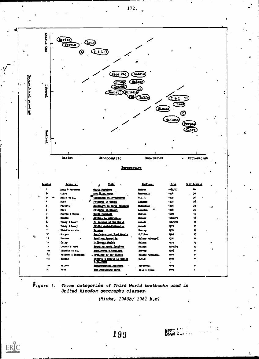
' 172.P
A
0
ffime
2.
2.
6
7
8.
7
77
(ems) cE9.
0
Re.ciat
611EX:IL
Lest I MomsMar*Solt. et 41.Pie*Itsva*ttOleo
Ferris 11 Tempbiddis
8. teung Lem8. Toms 1.41/41,7
11 Dinkel* it al.12 110r4101
13
111 &M.,45 (buret I Ion,16. 01.014 .t 41.
*clean I 11/4441/401114044
b walitor1441
ethnocentric Non.reciet
Perevective
tlosld144 Third. Vor14
adirlttalt1SIMakALia0111.11iiiitUidLalkaleakaAUICILAIL212211.
ILhattlisiAbide. L.33 Radom At the 124214
julgeoliadkiBoasharablasuatteLliadsPleat). mizzeLleDigit Mott.fameJsziglatkei
Eraliegutla12ent
srsub_thiatosinzinittelek2ssease
let.etttinktettli
Anti-raciat
Zit or fo1/42030
1144442 tmen11/4444o1/414 197t
,
0.7.P. 1975 36
14001.11 1973 26
Naaalllaa 1975 25 worlI
koom 1976 Y4
Rates ire
tkdder 1968/73 18
.241/4414 1962/76 18
624414 1979 18
Harm 1976 1?
1969 16
Nolan 11/40404411 1970 14
11/41444 1975 13
*gem 1971/75 12
Norm 1976
N41404 1402444411 1977 11
0.12.11. 1,72 4A
110414441 1973 11
2411 1 Worst 1979
11,
Figure 1: Three categories a Third World textbooks used inUnited Kingdom geography classes.
(Hicks, 19801)11981 12,c)
193+
9
4

\,
173. .
. .
, ..
are often ethocentric in-approach, and though well-meaning in
their "investigation of Third Worldissues contribute little
to multicultural understanding. Whilst they appear to offer'
attractive explanations about poverty, development, world food
etc. they are often divorced frcim the reality they purport to
,represent. (Hicks, 1981b) .
The_overall messages about the Third World common to the textbooks in Clusteis
A and B are that: '
IV
1. poverty is due to inbuilt obstacles and/or chance;
2. Rostow's model is a valid one and if Third World countries do the right
Ithings, "take-off" will come;.
3. overpopulation is caused by too many mouths to feed in the Third World,
not overconsumption of resources in the Eiest World; ,1.4%
4. peasant farmers need education and everyone needs help;,
5. colonialism was the'best thing to happen to countries in the Third World
(if colonialism is mentioned at all);
6. minorities do not exist or need help in coping (Hicks, 1980a).
Hicks found similarly alarming results in his analysis of the treatment of
multi-ethnic Britain in 14 geography textbooks in the British Isles. He ,
found that most ignored that aspect of British geography despite the variety
of ethnic origins,of students in British classrooms. Controversial issues
were either ignored, trivialized, romanticized, and generally presented from
only one,viewpoint.,
Third; World and Urban Issues (Gill)
Dawn Gill's initial, research was on the ideological orientation of urban
geography' in inner-London schools in relation to the" various approliches to
Urban geography deVeloped in the 1970s (Gill, 1980). She has extended this
research to include the treatment of Third World issues as well. In particular,
she'has found examination syllabuses and the Geography for the:Young School
Leaver Project to be deficient through a biased explanation of issues Such
as world "problems", Negroes (not Whites) and crime in US cities, the life
of Bantu workers in South Africa, squatter settlements in the Third World,
Commonwealth citizens in Britain, and the role of governm ,nt and corporation
policy on changing industrial patterns and'resultant unemployment.
,She concludes that the requirements of syllabuses at CSE and GCE 0-leyel
0
1
ft
174. 1
in London are'loaded against student understanding of the processes at work
in capitalist. cities:9
A city which has a poor inner area surhouhded by yelatively well-off suburbs is in itself a spatial form which should be studiedby pupils. Geographers are satisfied with generalizations. Allcities are like this. .What they should be doing is explaining why.The city is a. built form which reflectCsocial inequality. Students
should be encouraged to ask how social inequality came into being
and how it is perpetuated, if they are to understand the spatialpatterns within a capitalist city. (Gill, 1982a).
She provides glarinj examples of how some of the Geography for the Young
School Leaver Project materials pointedly avoid such issues, and encourage
a benign acceptance of oversimplified and often inaccurate descriptions.
A reply by Beddis (1981) to these charges clearly places the Geography for
the YoUng.School Leaver project in Cluster B on Hicks' graph (Figure 1).
An Expanded Range of Inquiry.(Kent)t
The four British studies reviewed thus far have exposed. the cultural and
ideological orientations of geography textbooks' and teaching materials that
have'produced inaccuracies and bias through ethnoc,:ntricism, cultural supremacy
and racism. A team of geographical educators in the United Kingdom co-ordinated
by AshleyKeq sought, to expand. the range of inquiry into textbook bias after
the 1981 annual conference of the University Depirtmentof Education geography
tutors in Swansea.. The publication, Bias in Geographical Eucation (Kent,
1982), is the result of their madavours. The four chapters include a consideration
of sexism in geography (Bale), bias in the regional examples and scale of
sample studies. used by.geography teachers (Kent), bias in the interpretatioh
of phOtographs (Wiegand), and cartographic and statistical bias in textbooks
(Wright and Pardey). These four papers, in the0A,of Kent, are "a tentative.
introduction to a topic which clearly deserves fuller consideration by those
involved in geographical education" .(Kent, 1982). The papers by Bale, Kent
and Wiegand are introductions to the issues of sexist, regionaliand photo -'
graphiC bias. They define terms and review the literature, setting the scene
for '(hgopefully) more empirical inquiry, such as that by Moore (1978 on sexism*,
in social studies text books. It would have been useful if the publication
had done the same for ageism'in geography teaching, surely an issue worthy
of inquiry, given the'rapid "greying" of the world's population. (See Council
on Inter-racial Books for Children (1976) for an example of research on age-
ism in children's books.)
0*
#

it
175.
AN EXAMPLE OF TEXTBOOK BIAS
Wright and Pardey.provide the only empirical work inithe Kent publication.
Taking the teaching of South Africa as an example, they pursue an area of
bias the presentation of Africa in the geography curriculum) that Wright
has exposed onearlier occasions (Wright, 1978; 1979).
,
The verbal and photographic° content of several books on South Africa were 9
reviewed by Wright and Pardey in 1981 (Wright and Parley, 1981). In the
Kent'publication, they turned their attention. to exposing examples of bias
0
in the statistics and statistical maps in one popular an att'ractive textbook
used in Second Form
Two by Rice(1975).
and a'greai variety
popular that it was
in the United Kingom. The bbok is.Patterns in Geography
The book is characterized by many full-coloui photographs
of student-centred activities. Indeed, the'book is so
reprinted five times between 1975 and 1980 and has been
revised for Australian schools in a special edition (Rice and Hinds, 1978).
Despite this popularity, the two chapters (of.a total,of 11) oneSouth Africa
reveal gross inaccuracies and distortions in the presentation of life, mining
and. urban patternsin that country. These are Chapters 7 and 8. Looking
at the statistics and statistical maps alone, Wright and Pardey (1982) record:,
1. The theme of the first two pages of Chapter.7 is the racial composition.
of South Africa. Yet unlike seven other Forms 1-3 books reviewed;
and which explo"e the same theme, neither Rice (1975) nor Rice and Hinds
(1978) present a map of the allocation 'of land to the different races.
2. By contrast, their first map presents the Afrikaner version of the settling
41$ rc South Africa. The miPlfalsely records the Bantu southWard migration
stopping in northern Transvaal and.the Voortrekkers thereby occupying
an empty land.
3. A table of the population of South Africa by racial groupings contains
inaccurate data. For example, Rice (1975) tlaims the 1970 population
of Bantu people to be 12,750,000 (68% of total population) compared
to the 15,058,000 (70% of total population) as the 1970 census of South
Africa reveals. By contrast, the figures provided by Rice for Whites
in 1970 is 3,600,000,(19%)' when the census reveals a white population
of 3,7A1,000 (18%).
4. ,A second map plots the distribution of South Africa's population with
different symbols forach ethnic group. The Tap does not contain a
rt 2 02 -1

:176., .
scale, but cartographic convention Would leaeone to believe each symbbl,
regardless of race,..wouid represent the same number .of people. But
this is not so, for each Bantu 'symbolorepresents 106000 people while
each White symbol represents only 65,000 people (Rice, 105).
5.. The boundariesbof'South Africa presented in the map are incomplete and
.show South Africa to include parts.of Mozambique and the entire area
of two independent countries,' Lesotho and Swaziland. When the.area
and population of the.lattet twd are considered, the cartographic errors,
,are compounded. Each Bantu symbol then represents 1201000 people, while
each White symbol represents only 67,000 people (Rice; 1975).
6. Such cartographic inaccuracies lead pupils to interpret that Bantus
constitute 55% of the population and Whites 29% (Rice, 1975).
.7. The Australia edition ofLthe book (Rice and kinds, 1978) updates the
populatiOn figures to 19 3, but-presents the identical population dis-b ', A
tribution map as in Rice 1975). Calculations similar to those done
by Wright and Pardey (1982).for Rice (1975) reveal that each Bantu symbol
now represents 129,00.peOple (or 142,000 if the areas 9i Lesotho and .
tb,
Swaziland are excluded) compared to only 32,000 people per White symbol
(or 71,000 people per White symbbl if the areas of Lesotho and Swaziland
are excluded). Based on these figures, the racial composition of South
Africa is distorted to-present students with an interpretation of Whites
constituting 44.4% of the South African population and Bantus 43.3%.
8. Another exercise requires students to deduce the racial composition
of the South African population in three squares over the locations
of Cape Town, Johannesberg and Durban. These three sites are not named;
. students couldbe forgiven for believing6themto be randomly selected. ,
sites. Whatever the authors' intentidhs, the students' calculations
reveal the racial composition of the:population of South Africa in theselA
areas to be:
. 10% Bantu 'and 30% White in and around Capetown;
40% Bantu. and 30% White-in and around Durban;
50% 8adtu and 45% White in and.around Johannesberg.
Each. set of figures seriously overstates the White population and under-,
states the° Bantu, population of ,Sbuth Africa as a whole. Moreover, the
geo-political structures that lead tooWhite dominance of the cities
203 e
O

are not mentioned, let alone explained, analyzed of held up for values
inquiry.
9.. A sories.of map and photograph interpretation exercises on Johannesberg
emphasize the morphology and functions of a European city. The only
urban problem mentioned is freeway congestion! Soweto, the daily train
journeys ir6 Soweto to Johannes berg, the blight of the "illegals" and
the Black economy are not mentioned..,
10. The remaining maps and tables in the two chapters emphasize the White
economy - mining, steel and car manufacturing, urbanisation and retailing.
The exploitation of Bantu workers in such activAties is.not mentioned.
The high technology and capital inputs of such activities is alien to
thelife in the Homelands or the Bantu townships,features of the settle-
ment pattern of South Africacwhich are not mentioned'in either book.
These 10 points do not list all the distortions in the two chapters on South
Africa! Others may be found in the oversimplified treatment of the car in-
dustry (progressing because of government tax policies, not cheap labour)
and the role of multinational corporations in the SouthAfrican economy.
The only question asked of students in relation to the latter is to-list'-
the origins and'products of a lift of 35 companies! Nowhere at all in the
two chapters is apartheid discuSsed. In fact, the issue is trivialized by
a glib instruction to -
1.5 Heading: South Africa's population.
Write.a short essay summarizing the origins, number and
distribUtion of the population. Comment on the varied
languages. Explain what apartheid means.
or shown to'be an acceptable means of production efficiency by instructions
to -
4.2 c: Describe the annual migration of workers to the
mines (as shown in a flow map of .the number and direction
of worker travel).
d. With reference to the graph, state why the gold
mines are not short of labour.
e. Statk why the mines are able to employ Bantu
workers so cheaply.
(Rice and Hinds, 1978)
The human geography of South.Africa, along with its citizens. obviously awaits
.decolonizing! (Crush, Reitsma and Rogerson; 1982.)

17 :.
The distortions in Patterns in Geography Two and.ueographical Patterns high-
h omission and commission in geography
pgrtant issues aenies pupilr. the oppL
to reasoned conclusions on many import-
light distortion and bias caused by bo
books. The omission of attention to
ortunity to consider, analyze and co
ant questions of social justice. Cl ims that such issues are "too difficult"
or "too controversial" for young st dents appear lame when the chapters in
question also include the study of bverseas investment, multinational corpor-
ations, theoretical urban models a d von ThunPn land use patterns. The "sins
of OOmmission" in these chapters, ogether With these omissions, are suffic-
ient &) cause one to be reksonabl sure they were either deliberate attempts
to deceive pupils or the result o unforgiveably poor authorial research
and editing.
/ CONCLUSION
It is the duty of researchers vlio expose bias in textbooks to provide teachers
and-students with ways of coping with the distorted views presented. The
guidelines on textbook use fr the Manitoba Department of Education (1980)
has a concluding section wh' h offers guidelines for eliminating sex, race
and class bias: A short per from Henrikson and Patton (1976) contains
a number of sample less s designed to develop skills of discrimination using
biased textbook and lm resouraps. Moore (1975) presents activities with.
a similar goal b ed upon two history textbooks. Wright and Pardey (1982)
are true to is tradition and suggest seven activities for teachers and
students o identify the areas of bias and distortion in Rice (1975). They
incl e: statistical exercises, atlas work,the study of the same topic
2,41 different textbooks verifying historical claims in history` textbooks,
and class discussion.
" Ie
The -Kent publication Bias in Geographical Education (Kent,,1982) resulted
from a meeting similar to this one. A group of geographical educators real-
ized the importance of the issue and co-ordinated their research. Geography
teathing in Australia would be served if a co-ordinated investigation of
bias in geography textbooks resulted from this meeting of the Australian
Geographical Education Research Association. It woulk! be one way of illustrating
the relevance and usefulness of research to classroom teaching.
Issues for investigation might include:
205tv

179.
1. The portrayal of Aborigines in geography textbooks:
2. The portrayal of multi-ethnic Australia in geography textbooks.
3. The portrayal of women in geography textbooks.
P 4. The portrayal of the aged in geography textbooks.
5.. The portrayal of disabled people. in geography textbooks.
6. The portrayal of different races, especially in Third World countries,
and of minority groups `in the 'First and Second Worlds.
. '7. The nature of explanation in geography textbooks, that is do socio-
economic and political processes receive equal treatment as environ-
mental and perceptual explanations of phenomena anepatterns?
8. The nature of development and underdevelopment processes in geography
textbooks.
9. The ideological assumptions behind the selection of topics to present
and issues to pursue (or ignore) in geography textbooks.
10. Indications of cultural supremacy and nationalism in geography textbooks.
411. The regional and scale of study bias in the areas and case studies
presented in geography textbooks.
Geography teachers in Australia have a preference for using Australian-produced
textbooks. Major publishing companies such as Longman Cheshire, The Madmillan
Company of Australia, lieinemann Educational Books, Thowfs Nelson and Sons
and Jacaranda Wiley provide almost all the textbooks used in Years 8-10 geography
in this country. They require examination for ..Jas in the selection of content,
the themes presented, the perpsective taken and the means used to present
,it through omissions, inaccurate or distorted claims, and misleading and
unrepresentative photographs, maps, tables, graphs and case Studies'.4
Geographical educatorsinterested in further research in this area may go
in any number of directions. The variety of themes to pursue, the range
of publications, and the myriad forms that bias takes (see Boden, 1977; Roberts,
975) allow for. this. However, a co-ordinated research program requires limits to
such yarlaliY.Essentially, we-can go either of two ways after a list of
10 to 1.5 most commonly used textbooks are determined. A questionnaire issued
to 10 geography teachers in each State of Australia in mid -1982 revealed

180.
these to include:
Sale, Friedman and Wilsoi. Our Changing World Series. Longman
Martiot, Palmer and Thompson. Man and his World Series. Macmillan
Brereton, Gallagher, Sinclair and Wilson. A Geographer's World Series..
Longman ..m
Millikin-andCourtney. Explorations in Geography Series. Longman.
(The results of the questionnaire still requires verification from publishers'
sales figures.)
The alternatives before us are for interested researchers either
(i) to select a textbook or textbook seties and review it in the light of
the 11 issues listed above; or
(ii) to select an issue qr form of bias alid.investigate it across the range
of textbooks;
Interested people are invited to attend a special interest group meeting
at this conference to discuss these alternatives and begin planning a"co-
ordinated program of textbook research for Australian geography teaching.
REFERENCES t.
Asia Society 0976) Asia in_ American. Textbooks. New. York: Asia SOciety Inc.
Bale, J. (1982) 'Sexism in geographic education', in Kent, A. (ed.) Bias
in Geographical Education. Geography Department, University on-Edon
Institute of Eddcation.
Banks, J.A. (1969). 'A content analysis of Black Americans in textbooks'.
Social Education, December, pp. 954-957, 963.
Beddis, R. (1981). 'GYSL Criticised'. Bulletin of Environmental Education,
No. 126, p.23.
Blachford, K. (1972) 'Values and geographical education'. GeographicalEducation, Vol. 1 (4), pp. 319-330.
Boden, P. (1977) Promoting International Understanding through School Textbooks.
Berlin: Georg Eckert Institute for International Textbook Study.
Bowen, M. (1981) The Ecolca oc owled e: Paradi Chan e and the Teachin
of Geography. Unpalishe 2aper presents at 7t Con erence o
Institute of Australian Georgraphers, Bathurst.
Centre for World Development Education (1979) The Changing World and Geography.
London: Centre for World Development Education:
207

181.
Council on Inter-racial Books for Children (1976) .'Ageism in children's books'.
Inter-racial Books for Children Bulletin, Vol. 7(G).
Crush, Jr, Reitsma, H. and Rogerson, C. (eds.) (1982). 'Decolonizing,the
human geography of Southern Africa', Tijdschrift voor Economische and
Sociale Geografie, Vol. 73(4).
Crawford, S. (1976). The Developing World 2. London: Longman.
Donnelly, P. (1982).'Geography education for action', in Geography: Action
in SocietI. Papers presented at the 8th National Conference of the
5611iTATTeachers' Association of Australia, Melbourne.
Fitzgerald, F. (1979). America Revised: 'History Schoolbooks in the Twentieth'
Century. Boston: Little Brown and Company.
Fleming, D.B. (1982). Teaching the War in Vietnam: Shattered Dreams and Lessons
for Tomorrow. Pam presentdd to National Council for Social Studies,
62nd Annual Meeting, Boston.
Fleming, D.B. and Nurse, R.J.,(1982). 'Vietnam revised: Are our textbooks
changing?' Social Education, say, pp. 338-343.
Gibson, E.F.(1969) 'The three Ds" Diitortion, deletion and denial'. Social
Education, April, pp. 405-409.
Gilbert, R. (1982). Social Structure and Personal Understanding: Problems
for a Critical Social Education. Paper presented at the Australian
Council for Social Education Conference, Melbourne.
Gill, D. (1980). Spatial Inequality: Spatial'Form. Unpublished M.A.
dissertation. University of London Institute of Education.
Gill, D. (1981) 'Geography in ILEA', Issues in Race and Education. Nos.32-33.
Gill, D. (1982a). '14-16 Geography in London: An assessment of its contribution
to multi-cultural educat'ion'. ILEA Geography Bulletin, No. 14, pp 8-17.
Gill, D. (1982b) 'Review of The Changing World and Geography'. Bulletin of
Environmental Education. 'No. 133, pp 26-27.
Ginn and Company (1973). Treatment of Minority Groups and Women. )New York:
Ginn and Company.
Grassby, A. (1982a). 'The multicultural confusion'. Education News. Vol.17(1),
. pp. 23-27.h
Grassby, A. (1982b) Cultural_ Bias in Primary Textbooks. Canberra: The
Commiiiioner for.Community Relations (mimeo).
Griffin, W.L. and Marciano, J. (1979) Teaching the Vietnam War: A Critical
Examination of School Textbooks and Interpretive Comparative History,
Utilizing the 1)entagon Papers and Other Documents. Montclair, N.J.:
Allanheld, Osmun and Company.
Griswold, W.J. (1975). The Image of the Middle East in Secondary School
Textbooks. New York: ,Middle East Association of North America Inc.

182.
Hall, S.J. (1,976) Africa in US Educational Miterials. New York: African -
American
Harris, N.H. (1969) 'The treatme t of Negroes in books and media designed
for the elementary schoolA Social Education, April, pp. 434-437...
)
Harvey, D. (1973) Social Justifte and the City. London: pdward Arnold.
Heath, D.E. (1.981) 'A map exercise 'for teaching about the war in Vietnam'.
Journal of Geography, M4rch. pp.101-104.,
Henriksen, E. and Patton, W4 (1976). Guidelines for Using Racist/Sexist
Materials in the Classroom (ED 170429)
Hicks, D.W. (1979a) 'Global'perspectives in the curriculum; et geographical'
contribution'. Geography, Vol. 64(2) pp.104-114.,
Hicks, D.W. (1979b). 'Two sides of the same coin; An exploration of the:
links between development education and multicultural education'.
New Approaches in Multiracial Education, Vol. 7(2), pp\105 '(Reprinted
in The New Era, Vol. 60(2) 1979). 1
, \
es of the World: An Introduction to Bias in TeachingmLli
onai Paper No. 2. Department -for Education in Develop-
'the Centre for Multicultural Education, University
e'of Education.
Hicks, D.W. (1980a) IMaterials. OccasI
ing Countries and' of London Instituft
Hicks, D.W. (1980b) Images of the World: What do Geography Textbooks Actually
Teach about Development? Paper presented-at Book Exhibitioh and
Conference, "Development Education: Education for Life in a hanging
World", University of London Institute of Education. (Reprinted in
Cambridge Journal ..of Educations Vol. II(1), 1981, pp.15-35)
Hicks, D.W. (1980c).Textbook Imperialism: A Study of Ethnocentric Bias
in Textbooks with Particular Reference to Geography. Unpublished PhD
thesis, University of Lancaster.
Hicks, D.W. (1980d). 'Bias in books: Not recommended', World Studies Jouroal,
Vol. 1(3), pp 14-22."
Hicks, D.W. (1981a) 'How biased are geography textbooks?' Time Educational
Supplement, 10.4.81.
Hicks, D.W. (1981b) 'The contribution of geography to multicultural under-
standing'. Teaching Geography, Vol. 7(2), pp 64-67).
Hicks, D.W. (1981c) Bias in Geography Textbooks: Images of the Third World
and Multi-ethnic Britain. Working Paper No. 1. Centre for Multicultural
Education. University of London Institute of Education.
D.W. (undated). 'The perfect man: Some reflections on bias in books'.
Libertarian Education (mimeo).
Hutton, D. (1982). Ideological Assumptions in History Teaching and Textbooks
Unpublished paper presented to Roundtable Discussion, "Research Directions
in Social and Environmental Education", Australian Association fc4
Research in Education, Brisbane.
209

O
183.
Joyce, W.W. (1969) 'Minority groups in American society: Imperatives for
educators'. Social Education, April, pp. 429.433.
Kent, A. (ed.) (1982) Bias in Geographical Education. Geography D '.rtment,
University of London Institute of Education.
Leach, B. (1973) 'The social geographer and Black people: Can geography
contribute to race relations?' Race. Vol. 14(2),,pp 230-241.
P Maher, M. (1982). Obstacles to Environmental Education: AHegembnic Hypothesis.
Paper presented to 2nd National Conference, Australian,Association forEnvironmental Education, Brisbane.
Maritoba Department of Education (1980). Confronting the Stereotypes for
Grades 4-6: A Handbook on Bias. Volume II (ED205274).
McDiarmidl G. and Pratt, D. (1971). Teaching Prejudice. A Content Analysis
of Social Studies Textbooks Authorised for Use in Ontario. Ontario
InstitUte for Studierin Education.
Milner, D. (1975) Children And Race. Harmondsworth: Penguin.
Moore, R.B. (1975). Two History Texts: A Study in Contrasts. A Study Guide
and Leison Plan. (ED 164209).
Moore, R.B. (1978). 'Sexism in textbooks' Social Studies, Vol. 69(3), pp
112-116.
Noronha, L. (1978) 'The presentation of India in 'Australian textbooks'.
Ethnic Studies, Vol. 38(1), pp 11-18.
Peet, R. (1977) Radical Geography: Alternative Viewpoints on Contemporary
Social Issues. London: Mithnen.
PiskunoV, A.I. and Dneprov, E.D. (1978) 'The Great October Socialist
Revolution anoPthe beginning of the construction of the Soviet School'.
Soviet Education, Vol. 20(4A,5), pp. 8-22 (EJ 185998).
Prieswerk, R. (ed.) (1080). The Slant of the Pen: Racism in Children's
Books. Geneva: World C.---rCcrE7F.---ouncilouz
Rice, W.F. (197S). Patterns in Geography Two. London: Longmfn.
Rice, W.F. and Hinds, R.W. (1978). Geographical Patterns. Melbourne: Longman
Cheshire.
Roberts, N. (ed.) (1975) Macmillan Guidelines for Creating Positive Sexual
and Racial Images in Educational Materials. New York: Macmillan.
Sibly, J. (1982). 'Global world views: Australia's energy future and geography
teaching', in Geography: Action in Society. Papers presented at the
Australian GeografAY Teac)ers' Association 8th National Conference,
Melbourne.
Storm, M. (1971). 'Far ny places and strange sounding names'. Parts 1-4.
Teaching World, 2 .71, 4.6.71, 11.6.71, 2.7.71.
210

.
184.
0
Storm, M. (1978) qiulti.ethnic edu6ation and geography'. Schooling and
Culture, Issue 3 (Autumn).
Stuart, J. (1977)..The Unequpl Third, London: Edward Arnold.
Wiegand, P. (1982). 'A biased view's in Kent, A. (ed.) Bias in Geographical
Education. Geography Department, University of London institute of
aucation, pp.' 25.36.
A.J. (1982). Educational Materials and the Corporate Sector:.
Some Ideological Implications. Paper presented at 2nd Conference of
Australian Geographiddl Education Research Association, Sydney
Wolforth, J. (1976j. 'The new geography - and after?'. Geography. Vol.
61, pp. 143-149.
Wright, D.R. (1978). qmical Africa in 'the Geography Curriculum. Unpublished
MA dissertation4 Oniversity of Londan Institute of Education..
Wright, D. (1979) 'Visual"images in geography texts: The case of Africa'.
Geography Vol.' 64(3).
Wright, D.R. and Pardey, D.E.;(1981) 'Distorting the 'picture'. Times Educat-
ional Supplement. 6.11.81. 1 1
'Wright, D.R. and Pardey, D.E. (1982) 'Bias in statistics and statistical .
maps: The example of South Aftica', in Kent, A. (ed.) Bias in Geographical
Education. Geography. Department; University of London Institute of
ETZEifIR.
Zimet0, S.G. (1977) Print and. Prejudice. London: Hodder and Stottghton.
I
211

0
t
4
t.
189.,
4
TEACHING GEOGRAPHY TO LESS-ABLE 11-14 YEAR OLDS --,
4
. 'Graham Corny*
and
Eleanor Rawling**
ABSTRACT f
This paper reports on some recent work carried out by
one of the Working Groups of the British GeographicalAsdociation during 1981 and 1982.
The Working Group on New Techniques and Methods in
Teaching Geography undertook aysurvey of teaching
geography to less able 11-14 year olds.in a selection
of BritisO schools. Graham Corney and Eleanor Rawling,
Secretary and Chairperson respectively of. the Working
Group, summarise important aspects of the survey in
this paper. The four main sections deal with (1) the
as and objectives o f the survey, (2) the survey design,
implementation, and methodb of analysis, (3) selected
findings and (4) issues.identified and recommendations
for further work.,
Whilst responsibility for the accuracy and main emphases
of the paper rest with?the authors, the planning and
execution of the survey and the analysis of findings were
full Working Group activities. The other full members of
the Group. during the 1981-82 period were: Neville
Grenyer, Paul Gwilliam, David Hall, Bob Hammond, John
Hancock, Andrew Herdman, Tony Pearce, and John Tresadern.
The full report 'Teaching Geography to Less-Able 11-14
Year Olds; Report of a Surveys is now available in
published form from the Geographical Association, Sheffield,
U.K. ,
O
* GrahmiiNCorney is a Tutor in Geography, Department of Educational Studies,
University'df. Oxford.
** Eleanor Rawling is Associate Director, Geography 16-19 Project,
Institute of Eftcation, University of London, U.K.
212

A
Introduction0
The teaching of geography to pupils of below average ability is an issue of
increasing concern to geography teachers and other involved in geographical
education. This concern is reflected in a number of ways; one of these is
the frequency with which the British Geographical Association is asked to
provide advice and practical guidance.
Partlyin response to this situation, the Association's Edudation Standing
Committee requested in 1980 that the Working Group on New Techniques and.
Methods should explore the issue and suggest ways in which the Association
could be of help to geography teachers.
0
The Working Group, iriacceptinvelis invitation, decided that an importaht
first task was to collect information about teaching geography to less abWo
pupils. Frbm this information base, appropriate research and development
work could then be undertaken.
Accordingly, the Group, conducted a,survey during 1981. This paper Provides
a summary of aspects of that survey under four headings:
1. Aims and Objectives of the Survey.
2. Survey Design, Implementation and Methods of Analysis.
3. Selected Findings
4. Issues Identified and Recomerendations For Development Work.
1. AIMS AND OBJECTIVES OF THE SURVEY
The overall aim of the survey, as stated in the Introduction, was to collect
information as a basis for further work. This aim was expanded by a set of
more detailed objectives:
1. to clarify the meaning of the term "less able" as. used by clasiroom
teachers, and to identify methods used to define these pupils;
2. to identify the particular learning problems experienced by lees
*able pupils as apparent in their, work in googiaphy, and to recognise
the implications of these for geography teaching;
213

se
O
187.
,.
3. to identify the particular characteristics of geography which
provide both problems and potential in-its use as a medium for
educating less able pupils;
4. to-gain information about organisational `Orovision within he
geography department for less able pupils and to collect some
examples of successful teaching strategies;
5. to examine the criteria used by teachers to judge the success of
teaching strategies carried out with less able pupils;
6. to make recommendations in relation to those issues and those
teaching strategies-which would merit further research and/or
levelopment work.
. SURVEY DESIGN, IMPLEMENTATION AND METHODS OF ANALYSIS
ti)` Survey Design
In planning Wimp.Oment the stated objectives, 'certain considerations.
had to be taken into account. These influenced the choice of survey
* methods and the identification of survey schools.
. .
One consideration was that a balance had to'be drawn. There was the
. need to make,respectable both the survey and the analysis of findings
in terms of the conventions of an action research project, and also
a desire to provide information and practical assistance to teachers
as quickly as possible. Another consideration was that the work had
to be within the Gr9up's limited resources of time, people and money._
Consequently, three major decisions were taken affecting the nature
of the survey.
The first was to focus on the 11-14 age range. It was felt that this
was an important and clearly idenLifiable target' group. The great
majority of pupils in this age range study geography in same fora.
The second decision was to collect information from teachers by
interview. It was felt that personal contact with teachers was more
likely'to provide the detailed information required than the more
mechanical, less personalised task of completing a questionnaire.
In addition, use of an interview would allow greater flexibility.
214

188.
4
*Questions which had been identified advance could be asked, but
it would alsobe,possible to take account of individual situations.
0 Thus, valuable points which might not have been predicted could be
followed up, and there would be opportunity for teachers to talk
about issues which they felt to be important. It was planned to
supplement the detailed information arising from the 'interviews with
basiC data collected through completion of a brief questionnaire.
The third decision Was closely related to the decision to interview,
an!' this was to adopt a case-study approach and so to focus bn a
limited number of schools. Selection of schools thus became of
fundamental importance so that a representative range of schools
would be included. Initially, Group members proposed schools where
'personal contact suggested that an interview would be both valuable
and practicable. Background information about twenty two such
schools was obtained, and the details were analysed both
qualitatively and quantitatively. Twelve schools were eventually
selected on the basis of general loceition,*catchment area character-
, istics, size, and aspects of school organisation.'
The schools are located in several areas of England and Wales, and
their catchment areas include inner city, suburban, and rural
environments. Sizes range4from 375.to 1750 pupilest and school types
include' a middle school and comprehensive schools. catering for 11 -16
and 11-18 years. In.some schools, geography is taught/io classes
with pupils.from the full ability range; in others, to classes with '
a wide spread of pupil abilities but where remedial pupilsare
withdrawn; and in otherso'teachina groups for geography are composedteaching
on the basis of banding or settingiby.ability. Geography sometimes
appears as a separate subject on the timetable; in other schools it
forms a. component of an integrated studies or humanities course.
Further details of the case study schools are given in FigOre 1.0
Having decided on the nature of the survey and selected the schools
.which would be involved, attention was,given to developing and
carrying out the integiew. Several members of the Group wished to
interview teachers in the case study schools, and a team of six was
4
I
215

Figure. 1
uSchool Total
Noe.OM.11/12 yr6
Type ofSchool
CatchmentAgee
Place of Geography11/12yrs 12/1Syre 13/14yre
ws of Nrs. Mooted to Ceog.11/12yrs 12/13yrs 13/14yre
Organist% of Teaching Groups
11/12yrs 12/13yrs 13/14yreTeachers
11/12yrs
used12/13yho 13/14yrs
1 1750 60 Comp (M)11-18
InnerUrban
$(Co) S(Co) $(Co) 2.0 1.5 2.0' M St * St ITS%
2r8 618 °
2
3
1534
1400
260
250
Comp (M)
11 -18
Comp (M)11 -19
Rural andwandCommur
Urban ClSthIndustrial
S(Co)
S
S(Co)
9
S(Co) 1.S 1.5 1.5 R 0 9
u
3r
3r5
.
sr0 trs
-8 .
. Li 1.3 2.04
.
R(R) R(R) .M(R) if Sr
.
3
4 1340 230 Comp (M)11-10
UrbanNewtown
S(Co) S(Co) S(Co) 1.S 1.5 1.5 8 8 .., 8 3r3rS
3r 3r
5 1300 210
1
Coq (0)11-18
Inner Urban(Social
Priority)
S(Co) 11(C) S(Co) 0.52.0
2.0
..
, M(R) 0 8 6r sr
6 1265 221 comp (a)11-16
RuralGarroter
.
S(Co) S(Co) S(Co) 1.2
.
1.7
-
1.2. R(R) 11 + S 21 IPirs
3r, Jo2111
Sr
.
7 1100 2S0 Comp (M)11-10
.,
Suburban S(Co) 9(Co) S(Co) 1.6 1.6 1.6 R(R).
S 51 ' sr fir
9 935 132 Comp (0)11-18
InnerUrban
S(Co) Rfit) R(rea)1.2 1.2 1.2 n M n sr, 1P
1r80
sr
9 200 me. Comp (P)11-16
Urban Cl9th
IndustrialS(Co) S(Co) S(Co) i.5 2.5 2.8
I
M M M 1r, IP115
Or 41
10
11
900
SSS
172
105
Comp (M)11-16
Comp (M)11-16
SmellMarket Town
Suburban andInner City
C(Co)
C(Co)
S(Co)
9(Ca)
S(0)
S(Co)
4.5° 1.5 1.5 Ms R 8 3r
3r5
37-,..
3r
'2.5* 1.8 1.5 M R M 1r375
it
0r8
lr219
12 376 94 Middle (M)9-13
UrbanUniv.Town
C(Co) 8(Co)
.
n.s. 3.0s
I
1.0 n.s. N 8 n.s. 479 IPS . n.a.
0216 217

4.
4
'Ar r
.
4
4
190,.
eCCKeyto
.gN.B. Information pertains to the 1991/82 academic year
KEY.. TO MIRE VI ATIONS z
PLACE OF GEOGRAPHY
S . as e'esparate subject
C combined:or integrated
.40(Co) .compulsory fos:all pupils
(0) s 3:*.optiOnal
ORGANISATION OF TEACHING GROOS 4
M mixed ability
11(R) 'mixed ability but remedial withdrawn
classes mixed within broad ability banding
teaching groups set according to ability in geography
St streaming exists for year group as s whole
TEACHERS USED
F a full time geography teacher
P a part. time geography teacher
FS full time teacher shared with another 'subject department
-PS at part time teacher shared with another subject department
* symbol relate° to Combined Studies not just Geography
218
-., 191.
set up.
In order ensure compatability of data collected by different
interviewers, a semi-structured interview schedule was prepared.
The main interview themes were prepared in an initial planning
session (Figure 2).. Detailed questions' under wigs)) heading were
subsequently identified through further discussions, consultation
with advisers, and piloting with teachers. The short questionnairet
was also prepared and trial].ed in schools.
Initial contact was made with the Heads of Geography in the case
study schools to ensure theirmillingnosm to participate in'the
survey. This as followed by a formal letter, explaining details of
the survey procedure. ,The questionnaire was enclosed with this
letter and schools were asked to complete this prior to interview.
The Whole of this planning process occupied the period April -
September 1981.
(ii) Implementation
Inierviewa took place in September and October . They_were held
either in school, or in a location where interruptions homed less
likely. The time taken varied according to individual circumstances,
ranging from about forty fille minutes to almost two hours. Some
interviews were tape-recorded and subsequently transcribed; in others,
notes were made by the 'interviewer and subsequently written in report
form.
A full return was' oPtained. Each school provided a completed
questionnaire and enabled the Head of Geography to participitte in
the interview. At eons schools, another member of the Department
was also interviewed and the responses have been valuable to the
Group, although not used in the official report.
(iii) Methods of Analysis,
Analysis took place in a series of stages over the period November
1981 - JUne 1982.

a
Figure 2
192.
4
Isimmcw VLS: MAIN READ/NOS
.1
1. Definition1of the.less able pupil.
2: General learning problems noticed-in geography lessons.
Characterietics about geography which cause rroblems for pupils.
4. Special provision in the: geography department for less able pupils.-
S. Judging success in teaching the less able.
6. Special provision outside the geography department for less able pupils.
7. 'Wimples of teaching strategies and materials.

193.
Initial processing involved the completion of collation sheets so
that transcript data and field notes could be summarised for each
. school.
Subsequently, the data was collated by question rather than by
school. This re-working process allowed a clarification of
responses and helped in the identification of trends and ideas.
The stage of preliminary data analysis was followed by a stage in
which the Group attempted interpretation of the findings. Thus key
issues which seemed to arise from the data were summarised. Based
on these issues, recommendations for further work were made. This
process was considerably aide: by consultations both with the teachers'
initially interviewed and with othei educational specialists.and-
advisers. '
The Final Report of the Survey was oompletedin July 1982. In the
Report, findings. derived directly from the interview dacaare
presented as far as possible without interpretation or evaluation.
The Group's interpretations and recommendations are set out in a
deparate_sectioh.
3. SELECTED FINDINGS
ea
Findings related to the key interview themes are fully presented in the.
ma n Report.D
,
Inlorder to provide in this paper something of the character of the inter-
views which took place and of the findings received, some results relating. ,
toione interview section are presented below. The section chosen is that
of `'the chaeacteristics of geography providing problems or potential for
pupils'.
Questions. prepared for use with each interview theme followed a common
pattern. An initial open question was posed so that teachers were given
the:opportunity to present their own views of the situation. This was than
followed up by a series of probing questions aimed at eliciting information
about specific points: Finally, with most themes, a last question again
194.
gave teachers an opportunity to pursue issues or raise new points not
included by the interviewer.
The initial open question with regard to the characteristics of geography
drew this from one teacher:
"Well - I think there are a lot of very positive things about the sort
of geography we teach. But I'd say that in the pastthree years there
are the kinds of problems that I've mentioned before - like the
difficulty of seeing relationships' between ideas, and like problems
with scale, direction and transferring information - for example,
particularly using atlases. I mean, they're quite good at transferring
information from the board iutotheir books, but when it comes to
picking up data from one source like an atlas, for example, and
'transferring it on to, say, a base -map, they can experience probleme.
think that it's a X oblem of spatial ability, spatial organisation
really."
These points were also mentioned by other teachers, so that in summary, it
was possible for the Group to identify that two categories of problem
caused by the nature of the subject were (a) the development of geographibal
skills and (t1 the understanding of geographical facts and ideas. In
addition, most teachers drew attention at some stage to the problems'
which
both they and their pupils found in dealing with attitudes and values. The
Group thus identified attitudes, values and the affective domain as a third
area of concern.
The characteristics of geography, which made it a'particularly effective
medium for teaching lees able pupils were commented on by some teachers,
although responses were fewer on this aspect. Fieldwork, mapwork and
drawing tasks were mentioned as having potential, as were the opportunities
provided in geography to refer to foreign countries or to focus on local
topics and issues.
In response to the more probing questions, many interesting points were
recorded. For instance, in talking about fieldwork, teachers revealed
three very different sets of attitudes.
one was that fieldwork was not carried out with less able pupils. Another
222
V.

195.
0
was that where fieldwork was carried out, less able pupils experienced
difficulties, even in simple, tasks,such as,dbservation and recording
4 information. The third was. that fieldwork had greax. potential with less
able pupils. Motivation was normally assured, simple tasks like observation'
and recording could be readily undertaken, and geographical ideas could be
illustrated in an enjoyable way. One teacher commented:
."the children that I've found moat difficult to dial with in the class-
ibom for a whole host of reasons are often superb in the field. They've
come into their,own. I think it's probably much more interesting edit
appears more rele:/ant than 'reanol something from &book, and that
catches their imagination much particularly if they have problems
with they feel more confident in their ability and jIerform
better."r."
In response to the open question ndluding-this section of the interview
on the characteristics of geograph several teachers.re-emphasised into
already made. It is perhaps, in sting to end this part of the paper
with the comments of one teacher chxelated to the general potential of
geography:
"I just think that it's a fascinating subject, and I would say that most
of the Departiient feel that, and that our enthusiasm comes over to the
kids. It is a very popular subject with all the kids.in this school."
4. ISSUES IDENTIFIED AND RECOMMENDATIONS FOR FURTHER WORK
The key lisues identified fiom the survey findings are itemised in Figure 3.
Related to each of the issues are recommendations from the Group for further
research and/or development work.
A summary of these issues and of the related recommendations is given below.
(i) Definition of Less Able Pupils
The survey revealed considerable variation, amongst teachers and
between schools, in the criteria used for identifying lees able
pupils. Even where reliance was placed on tests, a variety of these
were in use, covering a range of skills. More often it Seemed that
teachers used a range of personal criteria. Estimates of the
proportion of less able in a total year group population thus varied

196.
, 'Figure 3
KEY ISSUES '
(1) Definition of-Less Able
(ii) Ass acts of GenefIl Learning
reading, writing and number workoral worklimited concentration spansdifficulties with generalisationappreciating alternative viewpoints
(iii) Characteristics of Geography
use and interpretation of napsfieldworkunderstanding key geographical ideas
(iv) Teaching Strategies
resoUrce based enquirydrama and creative workstructured worksheetsrole play and simulationusing audio-visual aids
(v) Organisation of'Teaching OroupA
(vi) Judging Success
(vii) Inter-Departmental Cooperation
224

widely and so did strategies put forward for dealing with them.
The Group is of the opinion that clarification of the criteria by
which less able pupils are identified is an important topic for
development work. The preParation of suitable approaches to teaching
those with learning problems would be considerably aided if teachers
were better informed in this way. Further development work would
necessarily involve consultations with specialist advisers and
educational bodies.
(ii) Aspects of General Learning
Reading, writing and number work were the basic skills most frequently
mentioned by.teachers as providing problems, and so the development
of these ?kills is put forward by the .Group as one key issue in thisO
area.
Another issue concerns oral work. Teachers' opinions about oral
.work varied considerably: porno saw this as another area of difficulty,
while some teachers emphasised its potential.
Other issues related to three general learning characteristics which
teachers saw as being characteristic of leas able pupils - limited
concentration epans, difficulties experienced With generalisation,
and difficulties in appreciating alternative viewpoints.
A final issue in this area was the contribution of work in geography
to the broader social education of pupils. 0
In all these issues, there is a close relationship between the way
in which general skills can oe used to promote learning in geography,
and the means by which geography can be used to promote the
development of general skills.
Accordingly the Group recommends that research and development work
might usefully focus on investigating (a) the potential of geography
as a medium for a wide range of skill development and (b) the degree *
to which progress in geography is dependent on these skills. Part
of this work might include the gathering and dissemination of

198. .1
41
information about good teaching practice.
4
(ii) Characteristics of Geography
Two aspects of geographical work frequently mentioned by teachers
were mapwork and fieldwork. However, while the use end interpretation
of maps was generally seen ,as problematic with lessolable pupils,
fieldwork was considered by some teachers to provide major difficul-
ties, and by others to present opportunities for stimulating and
valuable work.
The Group recommends, therefore, that there is aimed for further
investigation of the 'opportunities and conatraints involved in both
using maps and in carrying out fieldwork, and for an attempt to plan
out some appropriate sequenced learning activities in these areas.
Another issue relating to the characteristics of geography concerns
pupil difficulties in understanding keyageographical ideas. This
was emphasised by many teachersi and 'it was suggested that modern
concePtually-bated approaches to geography are contributing to
make the subject leas accessible to slow learners. The Group feels
that there is scope for further work here, investigating the way in
which children-develop key ideas in geography and the extent'to which
choice of topic and/or teaching strategy might assist their learning.- .
(iv) Teaching Strategies
The interview responses revealed that there are several teaching
strategies which may have considerable potential with less able
pupils, but ich are under-utilised at present. These include
resource -bee enquiry, drama and creative work, use of structured
worksheets, le-play and simulation and use of audio-visual aids.
Each of these strategies has been identified as a key issue.
!
The Group reca rends that g44#11her work should be carried, out in
relation to some, at least,'of these strategies. The work would
clearly relate to the development of general learning skills ((ii)
above) and might include the preparation of exemplar materials or
guidelines.
226

(v) Organisation of Teaching Groups
The Survey revealed that less able .pupils weft taught in a variety of
teaching group situations. It seems that an issue worthylof further
study is the extent to which different organisational structures help
or hinder the effective operation of teaching strategies in geography
with leis able pupils.
The Group recommends that some form of study be undertaken to
elucidate these points. It is Aware that such a study would need to
operate in conjunction with other work on teachingitrategies. It
may also be the case that investigations would need to be conducted
on a large scale and over a long time period in'order to obtain.
meaningful results.9
(vi) Judging Success,
There seemed to be no common approach to judging success with less
able pupils. Some teachers relied heavily on formal testing; others
made extensive use of personal criteria related for instancelto
pupil behaviour or enthusiasm. It seems then that criteria and,
methods for judging success together comprise another issue worthy
of further consideration.
The Group believes that a necessary part of any work carried out to
identify suitable teaching topics or strategies should belthe
clarification of successful evaluation methods, linked cfOsely to
specified learning objectives. It therefore recommends that this
work should occur in conjunction with other appropriate studies.
(vii) Inter-DepartmentAl Cooperation
The Group has reconised inter-departmental cooperation as a crucial
issue. It was clear from the Survey that it was rare for differentt
subject teachers to meetin order to discuss the needs of these
pupils, or for them to make.,,any attempt at joint planning of learning
experiences.
It seems to the Group that opportunities are being missed here.
Accordingly, it is recommended that once some of the initial subject-
based work has been undertaken in geography, it would be valuable to
227

make approaches to other subject teachers. Suggestions might be
prepared for cooperation with other subject. areas, forming the basis
for such discussions. These might also assist,geography teachers to
play a positive role in developing school curriculum policy as a
whole.
Conclusion
In the preceding sections of this paper, we have summarised folr important
aspects of a Survey recently' carried out into the teaching of geography to
less able pUpils aged 11-14 in England and Wales.
n
Beeause of the nature of the survey and; in particular, its reliance on case
study data, the findings and recommendations-which have been outlined can
only relate to those case studies and can not be seen as'being representative
of an overall situation. However, the Group suggests that the issues
idehtified and the recommendations put forward are worthy of general
consideration.
The Group is also alien that all the issues are inter-related'and that
advances in ode area.may be dependent upon progress in another. For this
reason, although the Group itself will focus on a limited number of items
for further work, it has recommended to the British Geographical Association
that action be initiated on all these iesues during the 1982/83 academic
year.
The Group would welcome hearing of the results of any similar work under-,
taken in Australia on these themes.
Graham Corney Eleanarnewling,
Tutor in Geography Associate Ditezt7
Department of Educational Studies Geography 16-194)1=00ot
University of Oxford Institute of Education
15 Norham Gardens University of London
OXFORD 20 Bedford Way
OX2,6PY LONDON WC1H OAL
228

.1ATTITUDES AND APPROACHES TO TEACHING LESS ABLE PUPILS
IN YEAR 8 GEOGRAPHY IN QUEENSLAND
John Flan, Rodney %Gerber and Peter Wilson
o
ABSTRACT4
f
The departmental heads of thirty -four geography departments
in Queensland secondary schools were surveyed and interviewed
about the teaching of less able pupils An their geography
classes. Information was sought in seven areas: the way
the less able pupil is defined and identified, their learning
problems in geography, the featukei otgeography which cause
ptobleie for pupils, special provisions made in geographydepartments for less able pupils, ways of judging their
success in geography, special provision made outside the
geography department for less, able pupils, and successful
teaching strategies for them in geography. The results of
this investigation are reported here along qith several
suggestions for reinforcing existing successful practices,
and several recommendations for reform. r
t
CY
This study is a replication Of a research project on teachingless able pupils.
in the lower forms in English secondarischools co-ordinated by the, New
Techniques aid Methods Working Group. (chaired by Ms E.,R+lingl, of the
Geographical Association. That'study is repOrted in ap4per Corney and
Rawling tabled at this Conference.
Three points may be noted about this paper by way of introduction:c.
1. The theme of teaching less able pupils focuses on a problem that has
been uppermost in the minds of geography teachers for many years, but
which has not received due attention from researche;s and ourriculumpr
developers in geography until quite recently, the GYSL Project not
Mr J. Tien, Dr R. Gerber and Dr P. Wilson lecture in geography and
geographical education at Brisbane College of Advanced Education, Kelvin
Grove Campus.
229

202;
withltanding. Yet,'in,the past three years, one can note papers,
booklet$ and chapters bn the theme by Pick and Renwick.(1979: 1983, forth-
comingl, Boardman '(1981), Dilkes (1982), Butler and Simmons (1982) and
Corney and Rawling.(1982).
2. The study is a,replication, something relatively rare in the literature
of geographical,0
and.even social educatiOn. It is one small step towards
patterli of replicative studies that Hagman (1980) claims is necessary'
for the development of a sounCtheoretical base for classroom practice.4
3..
Much of the data oollect4.on ups done by final year teacher education
students in the geography program at Brisbane College of Advancedy
; Education, Kelvin Grove Campus. They were required to use a structured
interview s%.aedutle toidiscuss attitudes'and approaches to less able
pupils with a geography teacher as part of their study of catering for4
individual differences in theclassrooM. The interview and analysis of
the replies were also used to promote the, idea of the "teacher -as- researcher ".
through action re' earch which has beesva feature 45f the Kelvin Grove
'geography teacher training course for several years (Wilson, 1980,' . .
'forthcomin'gt Wilson and Godwisit, 1981; Wilson and Widt, 1982).
CI
AIMS OF THE STUDY.
The study was a survey' of Queensland geography teadher attitudes and
approadhes to their less Able pupils. The focus was on pupils in Year8,
the first year of secondary education14n Queenalando-only, compared to the
wider Forms 1-3, focus of the English study. HoWever, it sought to obtain
informAion on the same seven areas explored in the English study:,
1. Definition of the less able pupil.
2. General learning prOblemsloticed in geography lessons.
3. Characteristics about geography which cause problems for pupils.
4. Special provision in the geography department for less able pupils.
5. Judging success in the teaching the less able.
6. Special provision outside the geography department for less able pupils.
7.' Examples of teaching strategies and materials.
The survey was in two parts: a preliminary questionnaire followed by a
structured interview with the head of departmentior co-ordinator of geography
in the school. (The interview was conducted with a senior geography teacher
iii three schools due to the unavailability of the head of department.)
THE SCHOOLS, CLASSES, AND TEACHERS IN THE STUDY
Thirty-four schools participated in the study. They included 'twenty state
.23 0

9
high 841s and seven private schools in tie 'Srisbanipetropolitanarea
and seven, state high schools in non-Metropolitan areas of Queensland...
Geography was taught to a total of 282 tear 8.claaaes.in these schools.
Gvgraphy was taught as a discrete disciplIne-based study in all bit seven
of'these schools. Fiv3 taught geography in an 'Integrated Studies course
in conjunction with history, one in a largely sociology orientated Study of
Society cour %e, and one in a humanities course that included English,
history and. geography.ti
Predominantly, geography was taught for three periods a week, with o mode
period length of,40 minutes. More periods per week wereAallocated to the
integrated'studies courses, but no indication was given on the. amount of.
time allocated ,to geography. Only one school reported that geography was not
fairly treated in its integrated course..
The 282dYear 8 classes were taught by.a total of 154 teachers/ These repre-i
sented-a'range o f experienced (over three years teadhin4) and not-so-,
experiencedteachers, and a range of specialist and non.zspecialist geography
*teachers (Table 1). The alarming feature of%his table is the 17.5 percent
of experienced and the 7 percent of. not -so-experienced teachers who,have no
background in geography whatsoever, but are teaching it in Year 8.
The other disturbing feature is the situation of 154 teachers takirg 282
Year 8 clasies, an average of 1.2 classes each, and few teachers specialising
'in teaching year 8 geography. However, it is pleasing to see that 50 percent?'
of the Teachers in the sample. are experienced specialist geography teachers.
A
TABLE 1: THE TEACHERS IN,THE STUDY0
Claimed Degree.
of
Specialism.
,>
Years of Teaching
3 yrs or less
N %.
Experience,
More than 3 yrs
N %
Total
N %
Specialist geographyteacher
11 7.1 77 50.0 16 57.1
"Second teaching area" 10 6.5 18 11.7 281 18.2
geography teacher
No geography back- 11 7.1 27 17.6 38 24.7
ground ,
.-...
TOTAL 32 20.7 . 122 79.3 154 100.0
231

Year 8 geography classes were mixed ability classes ip twenty-four of the
thrity-four schools (70.6%). An additional si:k schools (17.7%) had mixed
ability classes but had a policy of withdrawing less anle pupils, and pro-
viding them with specialist attention in a range of subjects, including
geography. Only four schools (11.7%) streamed classes on ability, chiefly
in English and mathematics (Table 2). This pattern contrdsts with the
Year 9.- 10 situation in most schools in which geography tended to be taught
to academically streamed classes only. Taple 3 illustrates the range of
i ability group organisation for. Years 9-10 geography classes.
It is important,to note in Table 3, that the 7 schools in which geography
is compulsory in Year 9 or Years 9-10 are the 7 private schools who have a
"grammar school" cufticulum and tend to enrol few less' able pupils. In. the
13 schools in which' geography may be selected from a osmorgasbord of subjects,
geography is generally on a "line" with the social science subjects for the
non-academic students (Citizenship Education and Social Studies). This
-reinforces the pattern in Queensland in which geography.is not taught to any
but the academically "top" students in Years 9-10.
Year 8 is a different situation where geography is taught to all students
mostly in m4.xed-Ability classes (Table 2). How do geography ,teachers recognise
their less able pupils? What are their attitudes towards them? What
approaches are used to teach them? These were the questions at the centre
of this study.O
ANALYSIS OF REPLIES
Thirty-four teachers (or groups of teachers) took part'in the interviews.
thgeneral, each interview provided between five and tan typewritten pages of
transcript. The following is a synthesis of the transcripts and is presented
under the seven headings outlined in the "Aim of the Study".
I
1. DEFINITION OF THE LESS ABLE PUPIL
Teachers used a wide range of definitions to define their less able pupils.
The responses ranged from short, definitive anSWers based on standardised
tests -
The official one first of all would,be"the I.Q. ratings andalso, the standardised TOLA scores from primary school
- to longer, more generalised comments based upon the teacher's subjective
view -
Teachers make mental notes of who are the "good" kids and
23

MOO
TABLE 2: THE ORGANISATION FOR TEACHING GROUPS IN YEAR 8 GEOGRAPHY
Ability Grouping N %
Teaching groups in geography contain pupils 24 70.6
of thig full range of ability
Teaching groups in geography contain pupilsof a wide range of ability, but less able .
pupils are withdrawn for special teaching
6 17.7
Teaching groups in geography are determinedaccording to an overall streaming policy
4 11.7
. in Year 8
, .
TOTAL 34 100.0
4
TABLE 3: ABILITY-GROUPS IN YEARS 9-10 GEOGRAPHY
.
.
Subject Selection Policy , N %
The subject choices offered to pupils meanthat only the most able study geography
13 38.3
Any'pupils may select geography from a 13 38.3
'smorgasbord' of subjects, but not all do
All pUpils study geography in Year 9 4 11.7
All pupils study geography in Years 9 and 10 3 8.8
The school policy forces the more able pupilsto study geography in Years 9-10
1 2.9
.
,
TOTAL. 34 100.0
who are the "bad" kids. The criteria used to judge may be things
like the way students respond in class or the standard of work
handed in.
Two state high school teachers oblected.,to the categorisation, of students
as less able with responses such as -
Experience would-indicate that it is most unwise to categorise
students according to'ability in Year 8, because, all too frequently,
initial impressions can mis-interpret different states of maturity,
a shy nature or an attitude to work.
Further, if students are categorised as "less able" then there is
often a "self-fulfilling prophecy" coming into force where the student
will react as less than able.
233

206.
My experience is that very few students could, or indeed should,be classed. as "less able" and a conscious effort should be madeby the teacher.to encourage all students to achieve. Being slow
'at. reading, counting or even reasoning doesn't deny the studentthe ability to participate in geography lessons (as it might in
more abstract subjects).
One teacher at a private girls' school took a divergent view towards the
A interview and said -
I will not be able to answer any of the questions on the interviewsheet as they are not relevant to this School. There are ho less
able pupils in geography as every student is capable of coping with.
the work.
A synthesis of the criteria used to define a less able pupil is provided in.
a summarised form in Table 4.
TABLE 41 CRITERIA USED TO DEFINE A LESS' ABLE PUPIL 41
Criteria Frequency
Reading Ability
Language Level .
15
12
Primary School Standardised Tests: 9
Primary School Results 7
Mathematics Ability 7
Overall Geographic Ability 7
Difficulty with High School Work 6
High School Results 5'.
Lack of Motivation 4\
Low Concentration Span 4
Physical/Emotiohal Problems 2
Lack of S. 2
Year 8 Entry Test 1
Knowledge Recall 1
Peer Group 1
Writing Ability 1.
Information. from Other Teachers 1.
Lack of Travel Opportunities 1
The main categories of criteria centred on the students' ability to read. and
their level of language development in relation to textbooks, worksheets or
234

r
notes on the blackboard. Several teachers said that geography was centred
on the written word (as was high school in general) and that students who
could not read had little hope with the subject (or with high school). The
other main criterion used was the Standardised TOLA Tests which are tests of
learning abilities, study skills, mathematical achievement, reading
vocabulary, reading comprehension, and are given to all Queensland Year 7
children in October of each year.
Other factors relating to the identification of the less able pupils which
emerged from teachers' comments include:
1. Most teachers do make a conscious effort to identify the less able
pupils in their classes.
2. However, the majority of pupils are in mixed ability classes so little.
can be/is done for the less able.
3. In general, teachers thought there were about ten to fifteen percent of
less able pupils in each year's intake. This amounts to three to five
-pupila -iireach-olass. of. th ty.
4. No system -wide policy with regard to less able pupils is outlined by
state, catholic or independent school systems.
5. School policies with regard to less able pupils range from very good
involving either special classes or specialists teachers to no policy
at all.
2. GENERAL LEARNING PROBLEMS NOTICED IN GEOGRAPHY LESSONS
All teachers were conscious of the less able pupil as an individual in their
classrooms, or as a small group in a specialised class. They were able to
identify some twenty-three learning problems they associated with the less
able pupils. These problems are shown in Table 5.
The list is quite comprehensive and gives'a good feeling for the learning
problems that a less able pupil is faced with. The serious problems
associated with reading which were outlined in the previous section are again
high on tl-e list, but the main problem centred on the pupil's ability to
concentrate for a period of time. One teacher at a State High School in the
country summed up the feelings of many teachers -
.... But mainly, the kid who can't concentrate - that's the main
problem - a child who has an attention span of 313 seconds, and you
do get them.
Another group of problems highon.the list centred on the pupil's intellectual
A

TABLE 5; LEARNING PROBLEMS NOTICED IN GEOGRAPHY LESSONS
<Problem Frequency
Low concentration span
Reading difficulties
Inability to retain/recall information
Inability to use nape" and diagrams
Inability to work with numbers
Writing difficulties
Inability to understand conpepts
Slow rate of work
Speaking difficulties
Behaviour
Poor attendance
Lack of interest (mctiwaion)
Doearr'tbringequiptetnUitIass
Poor skill development in fieldwork
Inability to think abstractly 3
Overall Language 3
Inability to follow simple instructions/explorations 3
Poor performance in tests 2
Poor listening 2
Lack of confidence 1
Lack of neatness and organisation 1
Unable to work independently 1
Frustration
24
23
18
16
15
14
11
8
7
.6 t,.
6
.5
4
4
and work study skills. Teachers frequently mentioned that theess able
pupil has difficulty remembering informatioi from the beginning of the period
to the end, let alone from one week to the next. Pupils had great difficulty
with the graphic areas of geography (especially topographic maps), the
numeracy of "new geography", and writing in notebooks and evaluation exercises.
3. CHARACTERISTICS ABOUT GEOGRAPHY WHICH CAUSE PROBLEMS POR PUPILS
The geography teachers in the study quickly recognised that the nature of
their discipline had many characteristics which caused serious problems for
the less able pupil thesimajor problems are outlined Table 6.
236

TABLE 6$ CHARACTERISTICS OF GEOGRAPHY WHICH *CAUSE PROBLEMS FOR LESS ABLE
PUPILS
Problem Frequency
Using'contour naps 18
Understanding abstract' concepts 12
Vocabulary 11
Practical and field work 10
Using small scale maps J 8
Reading skills" 4
Writing skills 4
Research skills 4
Matching photos to maps 3
Scale 3
Atlas skills 2
Map symbols 2
Ability to generalise 2
Skill acquisition 2
Lack of interest 2
Latitude and longitude 1
Reading instruments 1
Drawing ability 1
Numeracy 1
Simulation games 1
Preparation in Primary School 1
The pupils'ability to read and their level of language development, which
were outlined under Tables 4 and 5 are again high on the list. However, two
other abilities rate higher than the problem of vocabulary associated with
geography. Aspec..A of Mapping tend to dominate the list with the "old
favourite" of using contour maps at the top of the list (again!). This
reflects a belief held by most geography teachers that mapping is a central
aspect of the discipline, but also shows that geography teachers fail to
appreciate the difficulty of introducing mapping skills to pupils in the
early years of high school: Two of the authors of this paper have written
extensively over the past years on the difficulty of introducing maps and
mapping skills to pupils in schools. The results in this table show that'
most geography teachers would do well to read the most recent statement by

210.
Gerber and Wilson on this issue (Gerber and Wilson, 1983).
In contrast to the amount of data offered in Table 6, geography teachers
could offer only a few characteristics of the subject that make geography
an effective medium for teaching the less able. These characteristics are
shown in Table 7.
TABLE 7: CHARACTERISTICS OF GEOGRAPHY THAT MAKE IT AN EFFECTIVE MEDIUM FOR
TEACHING THE LESS ABLE
Characteristic Frequency
Use of direct observation 13
Use of audio-visual materials 11-
Use of instruments 4
Use of questionnaires 2
Emphasis on Local Area 2
Use of simulations
Use of colouring-in 1
This table reflects a belief held by most geography teachers that fieldwork
is a central aspect of the discipline. The use of concrete learning experi-
ences based on direct observation with use of instruments especially within
the local area waS suggested by most teachers. This table correlates closely
with Table 10 which shows the range of teaching strategies that geography
teachers have found useful with less able pupils. However, Tables 7 and 10
seem at odds with Table 8 which suggests that little real provision is made
for the less able pupil in the geography classroom. They are taught the same
topics, with the same teaching strategies and resources as all other pupils,
and are assessed with the same tests.
This table clearly reflects the pattern that emerged in Tables 2 and 4, which
was:
1. over seventy percent (70.6%) of the teaching groups in Year B geography
contain pupils.comprising the full range of abilities.
2. In general, less able pupils do not study geography in Years 9-10.
3. There is no sti.ndardised education authority policy with regard to less
able pupils.
4. School policies with regard to the less able are quite diverse.

TABLE 8: SPECIAL PROVISION IN THE GEOGRAPHY DEPARTMENT FOR LESS ABLE,
PUPILS
Is special provision
made?-:
Overall Response Frequency
Yes 20 58.8
No 14 41.2
_Provision Made Frequency
Pupil Organisation
Ability grouping
Withdrawal.
Smaller class size
No special pupil organisation
No comment given
Teaching Strategies
.,5
2
2
16)
973.5%
.Concrete learning experiences 7
Use of remedial teacher 6
Teacher empathy 5
SloWer. work pace 2
Easier exercises
No special teaching strategies 10
comment givenNo com 3
}38.2%
Selection of Topics
Same topics - less depth 6
Different topics 5
NO special topics 23 67.6%
Resources Used
Different 7
Same - used differently 2
No special resources 191
mNo comment given 673.5%
Monitoring of Pupils Work
Parental contact. 4
Closer monitoring
No special monitoring
No comment given 1385.3%
Assessment Policy
Different teats 5
Same tests - marked differently 1
Same tests 17
No comment given 11).82.4%
239

212.
5. Most schools and subject masters leave the responsibility for the less
able-pupils to the individual geography teacher.
Almost half the geography departments made no provision for the teaching of
their less able pupils. Some departments allowed for ability grouping within
the classroom. The teaching strategies tended to be the same for .the less
able as for the rest of the mixed ability group. Only.a few schools made
use of a remedial or resource teacher, if one was available. To repeat, the
majority of the less able moils were.talght the same topics with the same
resources and also sat for the same tests as all other pupils.
5. JUDGING THE SUCCESS OF TEACHING THE LESS ABLE
The geography teachers surveyed were in accord in their ways of judging their
success in teaching the less able pupils. These are shown in Table 9.
TABLE 9: JUDGING SUCCESS IN TEACHING THE LESS ABLE
Criteria Frequency
Use of exam/test scores 325
Discussion within the department 20
Discussion with parents 15
Discussion with pupils 14
Discussion with remedial teacher ,11
Classroom atmosphere 2
Confusion on pupils faces 2
Pupil enjoyment. 1
Intuition 1
The infOrmation provided in Table 8 showed that 82.35% of all geography
teachers evaluate the les:pable pupil in the same way as all other ability
groups. So, the fact that geography teachers use exams and test scores as
their main criteria for judging their success in teaching the less able is
quite consistent. The other chief area of judging success is by discussion
with a range of people including other members of the geography department,
parents, the pupils themselves and'the remedial or *reSource teacher, if one
is. available to them.

6. SPECIAL PROVISION OUTSIDE THE GEOGRAPHY DEPARTMENT FOR LESS ABLE PUPILS
Twenty-two of the thirty-four schools interviewed (64.7 %) stated that there \ -
was provision for helping the less able pupil outside the geography depart-, \\
went. In fact, much more appears to be done for the less able pupil outside
the geography a*ea than within. 4 school may have a guidance officer either.
`full or part tirnee a resource teacher and/or a remedial teacher. This group
of people help:to identify the less able pupils as they enter high school,
then work closely with the English department usually until the pUpils leave
the school. Work centres on special help for reading and language develop-
ment. However, many geography teachers saw this work outside of their
responsibility, or claimed that the pressure of work di4 not allow them to
do very much for the less able.
7. EXAMPLES OF TEACHING STRATEGIES AND MATERIALS
The previous sections have shown that geography teachers and departments are
able to identify the less able pupils in their classrooms,, but' from that
point on little is done to cater for their individual or, group needs. With
this in mind, Table 10 which outlines the strategies that teachers have found
successful in teaching the less able, appears atdds with the previous
sections. Perhaps, Table 10 contains the strategies:teachers would use if
time would allow a range of provisions to be made for their Tess able pupils.
Alternatively; perhaps teachers were being'modest in their responses reported
in Tables 8 and 9 because they felt they were not doing enough for their less
able pupils.
The most important strategies suggested in Table 10 are consistent with the
.characteristics of geography outlined in Table 7, that teachers felt made the
subject,an effective medium for teaching the less able pupil. These are the
use of a wide range of audio-visual materials and approaches with a great
deal-of practical work both inside and outside the 'classroom, and the use
of the local area .for outdoor learning. However, as many teachers said,
these strategies should-be used by any teacher of geography with any ability
level of pupil.
4

TABLE 10: SUCCESSFUL STRATEGIES FOR TEACHING THE LESS ABLE PUPIL
Strategy Frequency
Audio-visual approaches
Practical work
Outdoor learning
Lower level reading materials
Work suited to ability
Role play .
Slower pace
Clearer instructions
Repetition
more blackboard use
Team teaching
Inquiry
Friendly approach
Group work
Variety in each lesson
Language
Praise
Interesting content
Project work
Cartoons
Familiar examples
Local school contest
11
10
9
6
4
4
CURRICULUM IMPLICATIONS
The pkevious seven sections have synthesised the views expressed in inter-
views in thirty-lour Queensland schools with regard to teaching geography to
less able pupils in Year S. At least seven implications for the geographical
education of less Ahle pupils emerge from this study. These are:
1. Geography teachers,need a clear understanding of the nature of the less
able pupil.
2. Schools should establish a clear, practicable policy for teaching less
able pupils.'
1
3. Geography teachers needto become aware of and be able to implement a
range of strategies suitable for learning in mixed ability classes.

0 215.
4. Geography teachers need to become aware of and be able to implement a
range of strategies suitable for learning by less able pupils.
5. Geography teachers need to becoes astute selectors and developers of
appropriate resources for teaching geography to less able pupils.
6. Geography teachers need,practiceiin the construction of appropriate
forms of assessment which reflect the capabilities of less able pupils.
7. Geography teachers need to undertake professional development activities
to broaden their understanding of the 1essable pupil and to develop
suitable learning experiences in geography for these pupils.
1. GEOGRAPHY TEACHERS NEED A CLEAR UNDERSTANDING OF THE. NATURE OF THE LESS
ABLE PUPIL
Geography teac.iters mentioned a wide range of criteria of less able pupils and
a variety of learning problems exhibited by these pupils. The emphases on
reading and language deficiencies, as well as a weakness in number skills,
*are similar to those reported by Pick and Renwick (190).in a survey of less
able pupils in northern Engliuid. In addition, Pick and Renwick report a
/ stroncrooncern for these pupils' writing deficiency.- Thesecriteria, together
with the pupils' low concentration span and limited ability to reason, begin
to paint a picture of theless able geography pupil. The similarities
the characteristics of less able pupils in Queensland and northern Engl' d
suggests some baiis for generalising about these pupils. No doubt, the
'surveys which have been conducted so far have identified some of the a ributes
of less able pupils. However, more geography teachers need to reflect on
their pupils' abilities and performances to reinforce or extend the 1 er
characteristics identified so far. This need for geography teachers
identify the nature of leis able-pupils is bound in the idea of a t cher
diagnosing-how-pUpils learn and devising attractive learning activi es
suitable to each pupil.
2. SCHOOLS SHOULD ESTABLISH A WAR, PRACTICABLE POLICY FOR TEA NG LESS
ABLE PUPILS
Each school implements a range of subject curriculums in aidis ctive social
ruld envirbnmental context. In Queensland, the school context is more import-
ant because of the current emphasis on school-based curriculum/development.
In addition, the crucial criteria for identifying less able1 pupils in
geography, e.g. reading ability, language level, reasoning ility and low
concentration span, are likely to be crucial criteria for d gnosing less
able pupils in other school subjects. it would be,sensible, for each school
/
243

216.
to:draw. together.the views of all teaching and learning areas to generalise
on the-nature of lees able pupils. Such an exercise could well'indicate the
magnitude of the less4able.pupil,population in the school. If this population
is substantial then the-school administration ought to consider the develop-
ment of a clear, practicable policy to maximise the learning by less able
pupils. The existence of such a policy may be useful for alerting incoming
geography teachers to the existence of less able pupils in the school. rAs
well, this policy should prompt the school administration and teachers to
prepare to teach less able pupils effectively so that these pupils enjoy
learning in geography and achieve to their own abilities.. The preparation
phase to cope with less able pupils involves the careful consideration of
appealing strategies for promoting effective,learning in geography.
3. GEOGRAPHY TEACHERS NEED TO BECOME AWARE OF AND BE ABLE TO IMPLEMENT.A
RANGE OP STRATEGIES SUITABLE.FOR LEARNING IN MIXED ABILITY CLASSES
MOst of the geography teachers'in this study reported that their less able
pupils are taught in mixed ability'classes. There are administrative,
educational and psychological arguments for maintaining mixed ability classes
in schools. However, as the Department of Education and Science. in the
United Kingdom (1978) stated, there is limited, evidence of mixed ability
teaching. The authors suspect that the situation is similar in Australia.
Lidstone (1983) clarifies the concept of mixed ability teaching and suggests
that five principles are cruc.lal to planning and teaching in geography.
These principles are:U
(a) Much work by students will be undertaken on. an individual basis.
(b) Pupils will not be labelled by ability nor will they be placed in
competition against one another.
(c) Groups of similar.specificrabilities may be constructed for specific
purposes:
(d) Pupils of markedly different specific abilities will be required to work
together to a common end for some of the time.
(e) Learning experiences will compromise as wide a variety of resources and
activities as possible.
Lidstone illustrates these five principles of Mixed ability teaching with an
example of a unit on modern Ghana,(Figure 1):
How many geography teachers in Australia, of the many who have mixed ability
classes, can say that they practise the above principles and strategies to
maximise learning in geography?
244

mons vas
(toss able
'students)
1.
2.
ISMS 110 1.
(narystudents)
2.
3.
4.
ROUTE TWEE 1.
(Advanced
students) 2.
3.
Conceptual Content iLearning,Experiences
Difforsecee in living standards between
Ghana and Great Britain.
Subsistence agriculture in North *thane
including*
(a) the Larnees yews
(b) demonise on farming activities(o) advantages and dibadvantages of sell
suftioiency,
(4) social organisation and welfare
thrOlagebthe Outmoded family system,
migration of young and ambitious
people to urban areas.'
1. Reading and cosirthension (short
passages)* making notes following a
tight structure.
2. Simple'picture and map interpretation.
3. Line **static!. .
f
Everything on Route One, plow
The system of rotational bush yupowing and
variations in intensity of fardpg with
digitiser tree the farmhouse added to
Seatiese 2e and 2b of Mouth One.
National patterns of lead use.
Problems of eattle farmthq, e.g. disease
and climate variability.4
I. Everything on Route cue with reeding
extended to 2 pages in length andleth,
'panic structure for note making.
2. sop sketching with an eapbasis on
carefel !Shading and labelling.
!everything on Mouth Ono and Route Two,
plus*
An appreciation of why the extended family
remiss so important in North thou added
to Section 24 of Routs One.
An appreciation of why subsistenth/semi-
subsistence agriculture survives,
including*
(a) natural basards (unreliable climate,
Over blindness),
(b) attitudes towards risk sub-optimal
behaviour,
(c) the lied tome system,
(4) poorly developed transport and energy
infras
reg disparities.
/
1. Everything on Route Two with reading
extended to 7 pages in length with note
making guide limited to a set of sub-
beadini' .
2. Noce difficult map interpretation
questions.
3. Several naps to be.drewn and comparison
made between them.
4. Essay writing **ing a set of paragraph
headings.
7 A
S.
FIORE 1* sump Or CONCRPTGAL CONTENT' AND LEARNING BEFERZENCE9 IN THE ;SUMS sasscumuss memo OF THE
WORKBOOK ON "NUMMI NANA" (Liatone, 1993).
24 5

4. =GRAM *TEACHERS NEED TO BECOME AWARE OF AND BE ABLE TO IMPLEMENT A
RANGE OF STRATEGIES SUITABLE FOR LEARNING BY LESS ABLE PUPILS
Less able pupils are separated into discre e classes in some schools. When
this occurs, geography teachers have the oportunity to design and implement
learning activities specifically for these pupils. Geography teachers in
this study reported'the use of direct obseryational experiences and audio-
visual techniques as important strategies for teaching less able pupils.
However, these teachers did not elaborate a breadth of teaching'streategies
for meeting the needs of less able pupils. Pick and Renwick (1983) offer
advice and examples to develop effective teaching strategies for teaching
less able geography pupils. They suggest that cartoons, games', simulations,
problem-solving activities, inquiriesand field work in the local environment
and even pop music may be used to teach geography using the following teaching
guidelines:
(a) Identify teaching targets clearly.
(b) Avoid pupil failure and build up pupil self-esteem.
(c) Reduce, student dependence on others.
(d) Carefully grade learning material.
(e) Acept a slow speed of instruction.
(f) Maximise variety of resources and strategies.
(g) Consider motivational levels appropriate for the age grour concerned.
(h) Provide swift and constant feedback.
(i) Evaluate pupil progreos constructively.
(j) Reinforce learning and provide for adequate repetition and practise of
skills.
(k) Be relevant.
11) Be discriminating in the selection and production of resources.
('p) Constan4y evaluate one's own performance.
This means that geography teachers should design specific learning experiences
for less able students and should not use the activities designed for more
advanced geography pupils.
5. GEOGRAPHY TEACHERS NEED TO AECOME ASTUTE SELECTORS AND DEVELOPERS OF
APPROPRIATE RESOURCES FOR TEACHING GEOGRAPHY TO LESS ABLE PUPILS
4 A majority of the geography teachers surveyed indicated that they did not
c
use resources designed specifically for less able pupils. They tended to
use the sa,ae resources they used for the rest of their classes. Nevertheless,
there is a need to downplay the written word in resources used in geography
lessons for less able pupils. Hence, the use of cartoons, clear, simple maps
246

219.
and carefully structured graphics have been found to motivate less able pupils
to learn 'and to offer them the opportunity for making sense of the material
they are learning. Popular music has been found to be a very useful means
of communication with less able pupils. This music is often used as a
stimulus to learning involving cultural aspects and economic problems (see
,Renwick, 1981). Clearly, this implication intimates the necessity for
geography teachers to plan, to implement and to evaluate a range of materials
suitable for less able pupils. EXperience.is needed in transforming informa-
tion into forms suitable for these learners. This may involve simplifying
die information or it may mean reconstructing the information in a more
appropriate form, e.g a graphic time-line instead of a written account.
There is little, evidence to date that Australian geography teachers or text-
book writers have come to grips with the challenge of appropriate resources
for less able pupils.
8. GEOGRAPHY TEACHERS NEED PRACTICE IN !ME CONSTRUCTION OF APPROPRIATE FORMS
.OF ASSESSMENT WHICH REFLECT THE CAPABILITIES OF LESS ABLE PUPILS
Most of the geography teachers surveyed paid scant respect to the idea of
using assessment instruments which befitted the less able pupils. In fact,
half of these teachers used the same test for less able pupils as for other
geography pupils. The assessment instruments used with less able pupils
should reflect the type of learning the. las occurred and the nature of the
pupili themselves. Less able pupils have he to live with failure for moat
of their school years because they have had to sit for the same tests as
their more able peers. One solution for assessing less able, pupils is to
provide assessment activities built around the audio-visual materials used
in normal lessons and to ask the pupils a number of open-ended questions in
which th!re are no clear cut right or wrong answers. Issue-based tasks in
which the pupils express their own opinions should be encouraged. This
survey shOwed that moat geography teachers had responsibility for teaching
less able lOupiley. This suggests that these teachers should have\responsibility
for assessing their pupils ,as well. If this is so, then these geography
teachers Oculd be competent at constructing assessment activities suitable
to the. lessuable pupils. At present, few opportunities are available for
geography teachers to design such assessment activities and to share these
wits other geography teachers.
247

220.
7. GEOGRAPHY TEACHERS NEED TO UNDERTAKE PROFESSIONAL DEVELOPMENT ACTIVITIES
TO BROADEN THEIR UNDERSTANDING OF THE LESS ABLE PUPILS AND TO DEVELOP
SUITABLE LEARNING EXPERIENCES IN GEOGRAPHY FOR THESE PUPILS
The above implications for the geographical education of less able pupils
hints strongly of the need to offer teachers the opportunity to engage in
a variety of professional development experiences which focus on their
develcipment of 4 better understanding of the abilities of less able pupils
and on the development of teaching/learning experiences to meet the needs
of these pupils. Teachers need to be informed about less able pupils'
abilities to reason, to perform skills and to express themselves. As well,
teachers need to be informe about the, needs an6 in'erests of these pupils so
that the teachers can devise relevant, motivating learning activities.
Experience and practice in devising teaching strategies for leasable pupils
is vital if geography teachers are to succeed with these pupils.. Professional
experiences developed and implemented by groups of geography teachers will
be invaluable in meeting the 'challenge presented by less able pupils.
CONCLUSION
This study offers the opportunity for making genuine international
generalisations about the teaching of geography to less able pupils. For
its part, this Australian study indicates that geography teachers are aware
of many of the attributes of less able pupils in geography, but that we have
not done a great deal to meet the special, challenges of these pupils. This
has occurred because most teachers operate in mixed ability classes and
because these teachers have had inadequate training in handling and teaching
less able pupils The range of curriculiii implications highlight the
pressing need to make geography teachers mat, aware of the less able pupil
and to give geography teachers opportunities 1(:> become competent in teaching
these pupils and so to make geography a desired art of their formal
education. Obviously, this study is only a beginn g in the analysis of
different types of learners in geography and in the davelopment of methods
for these different learners.
248
221.
REFERENCES
Broadman, D. (1981), GYSL with the Disadvantaged. Sheffield: Geographical
Association. )
Butler, J. and Simmons, J. (eds) (1982), Helping Slow Learners with Geography.
Adelaide: South Australian Geography Teachers Association.
Corney, G. and Rawling, E. (1982), Teaching_Geographx_to Less Able 11-14
Year Olds. Sheffield: New Techniques and Methods Working Group,
Geographical Association.
Department of Education and Science (1978), Mixed Ability Work in Comprehensive
Schools. H.M.I. Series: Matters for Discussion No. 6. London:.
H.M.S.O.
Dilkes, J.L. (1982), "Teaching geography to remedial first-and-second-year
pupils in a comprehensive school by a non-specialist", Teaching
Geography, Vol. 7(3), pp 103-6.
Gerber, R.V. and Wilson, P.S. (1983, forthcoming), "Using maps in the geogrpahy
classrOom" in Fien, J.F., Gerber, R.V. and Wilson, P.S. (eds),
The Geography Teacher's Guide to the Classroom. Melbourne:
Macmillan.
Herman, W.L. (1980), "Towards a more adequate research base in social studies",
Journal of Research and Development in Education, Vol. 13(2),
pp. 24-35.
Lidstone, J. (1983), "Teaching geography in the mixed ability classroom", in
Fien, J.F., Gerber, R.V. and Wilson, P.S. (eds), The GeograOhY
Teacher's Guide to the Classroom. Melbourne: Macmillan.
Pick, W. and Renwick, M. (1979), Teachers' Perceptions of Less Able Pupils,
Geography Centre, Leeds Polytechnic (mimec4.
Pick, W. and Renwick, M. (1983, forthcoming), "Teaching the Less Able
Student in Geography" in Fien, J.F., Gerber, R.V. and Wilson, P.S.
(eds), The Geography Teacher's Guide to the Classroom. Melbourne:
Macmillan.
(1981), "Music and songs" in Boardman, D. (ed), GYSL with the
Disadvantaged. Sheffield: Geographical Association, pp 69-80.
(1980), The Classroom Teacher as Researcher. Paper presented at
Seventh National Conference of Australian Geography Teachers
Association, Adelaide.
Wilson, P. (1982), The Geography Teacher as a Researcher. Paper presented at
Eighth National Conference of Australian Geography Teachers
Association, Melbourne.
Renwick, M.
Wilson, P.

WJAson, P.
Wilson, P.
and Goodwin, X. (1981), "How do twelve and ten year old pupils
peiresive rivers?", Geographical Education, vol. 4(1), pp. 5-16.
and Widt, L. (1982), "How do fourteen year old pupils see desert
landscapes", Teaching Geography, vol. 8(1), pp. 9-12.

11
323.
GEOGRAPHY METHOD COURSES AND STUDENT MORALE
Sr. Anne Carter
Abstract
Inteke4t in aevvcat a4peeta 06 the education 06'
pAo4peative geography teacheta ,red me to make a
Atudy o geography method MAW in a Aetected
numbeA o Stitt4h Univemity Vepattment4 o Education.
One oli.the4e aapectA WA the moute 06 4tudent-
teachem. The method I choke 60A gathering data
RUA to vitit each PepaAtment 06 Education and tack
with the tee tuAen in Geography Method, the 4tudent4
taking the COUAAC, and a 4etected numbers. 06 pa4t-
4atudentb o the comae. 1 atao Oat in. on typiadt
Geography Method aesAiolus.
In SAWA Univeraiti.e4%the geooaphiaat education
component 06 Po4t Graduate Catiliaate in Education
COUAACA eompA44e4 three 4ection4: Theo/tett:eat,
Puce-tie-at and Teaching Practice. According to the
degree 06 empha4i4 placed. on one IA otheA Aeetion,
and the oAtentation 06 the couhae aims, 1 eta44ii2.ed
tack Geography Method course into one o three
categoAita: PUpit-temning 0Aiented, Edueationatty
0Aiented, Teacher Okiented.
Student morale tent ids been to be heisted to
coulae aims. Where theAe aims are Pupil-teoming
oriented and teaching AtAategiia attow active
4tudent.paAt442pation morale 40 Sound to be high,
but medium to tow where aims are 'Educationatty'
oAtented; medium to high wheAe they ate Teacher
oriented.
o."
As I visited each University Department of Bducation (herein after
referred to as U.D.S.) , I became increasingly aware of differences
in the morale of student-teachers. Conbideration of the importance
that high morale plays in a classroom led me to examine several aspects
of the Geography Method courses, in order to see if there is any
relationship between them and the morale of student-teachers. Although
there are other significant variables, I have selected the thrc.i aspects
which seem to be most Inf16.stitial to morale level, namely: id; Aims
of the Course; (ii) Teed 4g Strategic used; (iii) Content: as

224,
TABLE 1
INDICATORS OF STUDENT MORALE
INDICATOR
ATTITUDE
VERBAL
DESCRIPTION
CONVERSATION
FACIAL EXPRESSION
GROUP INTEREST
Relaxed or tense with peers and Tutorduring lecture/seminar/tutorial orworkshop sessions. Course seen asnecessary evil or fulfilling relevant aims.
Students express frustration or satisfactionwith course, as to relevance to classroom,teaching, relationship with pupils,.appropriate to geography teaching, practicein planning and presenting lessons, etc,
Positive or negative comments; universalagreement or disagreement about relevanceor non-relevance of course to, teachingpractice. Students chat easily andpositively about the course, or have littleto say except concisely-worded, negatiVecomments. Conversation ease or difficulty.
Tense, anxious, bored; or smiling, intent,interested. Maintaining the respectiveexpressions throughout entire interview orMethod Session.
Students as a co-oidinated group showed -
involvement and interest in planninginteresting/novel lessons and devisingmethods of presentation. Group showedinitiative; OR Group lacked interest and
waitedted for direction, Showeddoubt as to how to proceed with lessonstructure, etc. Unable to communicateeasily with Tutor.
MIIIM1111111!
1'

RELATIONSHIP OF STUDENT mama TO AIMS. OF
SELECTED GEOGRAPHY METHOD MOSES,k
UDE CAT MORALELEVEL
ORIENTATIONSEEN
TUTORS
ASBY
STUDENT
.
CORREL-ATION ,
DIFFERENCES BETWEEN TUTOR'SSTATED AIMS AND STUDENTS'
PERCEPTION OF THESE
4 2. N T&P TSP + 411.
1 3 H T T + Otudents omit 'dedication'
.
. Of teacher.1
7 2 H P( ST) T& P + Students emphasise both
ti and Teacher.
14 2 H P & 2' P & 2' + N11..
11 3 ,, if T 2' . + Ni. .
6 2.
,
M-H T& G T +'to o Students omit 'geography'. '
10 3 M-H G & T T + to o' Students emphasise Teacher.
.
21 2 M-H P.T&E T& E o Students ignore 'education'.
16 1 L 7 & E T,E,P o to - Students tend to looktowards Pupils. .
12 1 14.4 E T & E +.to o Studetilts see 'education'
as aim.2
. .
19 3 M-I, T,G,E E & T + to a Students see 'education'
as aim: ..
18 1 L G & T G (GT) + to o Students see 'geography'
as aim.,
KEY: MORALE LEVEL - H at High
M a Med4umOW
qeL atLOW'
1
1
.
ORIENTATION - T a TeachersP a Pupils 1
, G a GeographyE a Education
. .
CORRSLATTON - + a Strongo a Medium- a Little
.
.
.
.
.
.

22§.
to emphasis on thdbietical'and practical components of the Geography
Method courses. .Ihave selected twelve U.D.E,s to illustrate my
hypothesis.
Table 1 shows "Indicatbrs of Morale", from which devised the three
leveli; as to high N Medium and Low. If the Attitude of the group of
students was very positive, and students were actively involved in the
Geography. Method sessions, participating fully, e.g. in planning some
work or cohgtructing a model, or contributing freely to discussion, I
classified their morale as High. Similarly, if students early in the
interview expressed verbal their satisfaction withlphe relevance of
the course to their experience of teaching, I clasiified their morale as
High. This opinion was reinforced if students, as a group, maintained
this satisfaction throughout their conversation with me, and more
importantly,,,through interchange of opinion amongst themselves. I
observed, too, the facial expression of students which was evident by0
a relaxed and *failing expression. If the group appeared to be working
as a unit and With a positive attitude, secure; for example, with
techniques.of lesson planning, appropriate use of resources, and showing
an.easy working relationship with each other and with their Tutor, I
classed their morale as High, The opposite to these types of behaviour
were identified as indicating Low morale, whereas Medium lay somewhere in
between.
IC
Table 2 shows the relationship between Student morale and stated Alms of
Geography Method courses. Included in this Table are orientations of these
aims to one or other of three Categories into which each Geography Method
Course can be placed: Pupil-Learning Oriented; Teacher Oriented;
Educationally and Geographically Oriented. It also shows the degree to
which correlation exists between the course aims as stated by Tutors and0
the way the Students see the orientation of these aims.. This correlation
is important for it shows the desire that Students have to participate in
a course which will edUcate, guide and direct them as to the learning
needs of pupils and the ways 'by which they can help children to learn. ,
Students appear to look for a worthwhile goal and commitment and see this
as directed towards pupils' needs. Where Students see the aims of the
course as focussing on these learning needs and towards the education of
254.60

227.
TABLE 3
AIMS OF. GEOGRAPHY METHOD COURSES
ACCORDING TO" ORIENTATION
AimNo.
il
. ,
. Aim U.D.S.
(a) TEACHER ORIENTED :' ..
1. TO achieve. competence in classroom management and organisation. 1, 14
#2. TO be enthusiastic about geography teaching.
3: To encourage developmentof own potential for teaching.
4. .To prepare students to cope with Initial problems of Teaching
Practice and initial year of teaching - "survival" in the
classroom. .
10, 11
S. To encourage the student in the development of an attitude to
teaching as .a personal activity which offers continual
challenge., 21
6. To encourage confidence and enjoyment as ad teacher. 4 7
7. TO give students professional expertise as teachers. 4
.
..
(b) EDUCATIONALLY ORIENTED:
8. To develop the professional knowledge, understanding, skills,
attitudes and values appropriate to a probationary teacher. 12
9. To encourage critical analysis and evaluation of selected
materials., reports and research studies. .12-
10. To grow in knowledge and awareness of curriculum process and
development..
.
.,
21
(c), GEOGRAPHY ORIENTED:
11. To see geographical education as relevant to modern times. 18
12." To sustain continued interest and enjoyment in the study and
teaching of geography.1.9
,13. To produce teacher% committed tio'their subject. 6
14. To help geography appear interesting and realistic. ' 10 .
15. To equip students witiegeograithical skills for teaching.
geography. , 016
..
(d) PUPIL GRUNTED: N
16. To encourage pleasure at working with children. 4
17. To achieve honesty and integrity in selection of
geographical content. 14"
18. To have an awareness of the effective use of pupils' time. 14
19. To develop empathy for pupils as learners. 14
20. To safeguard the interests of children to ensure that, they
will develop positive attitudes, and to this and be
concerned about the type of geography to teach. 7
,
.
255

228.
student-teachers to serve those needs, their morale is high. They then
feel challenged by a worthwhile goal. However,, here the course aims are
directed towards theoretical elements and appearing to promote geography
per se as unrelated to children's learning, students gay the coarse in
Geography Method is irrelevant to the classroom at the present stage of
their teacher-education and training. Table 2 shows that there is a
relationship between (a) =rare, " (b) orientation of course aims, and
(c) the way in which students perceive the direction of the course.
Tables 3 (a), (b), (c) and (d) show samples of aims of Geographythethod
courses and their particular orientations. Numbers on the right refer to
the U.D.E. selected for the comparison. Table.2 should be read in
conjunction with.Tabae 3, for it shows that U.D.E.s whose aims are Teacher
and/or Pupil oriented, have the highest student moral level - these being
.U.D.E.s 1, 4, 7, 21 and 14. U.D.E.s 6 and 10 show a tendency towards
promotion of geography (See Table 3 (0) Airs 13 and 14). It is interesting
to note that in these instances, Student morale is slightly lower than in
the case of the previous five: In U.D.Z. 10,.Students emphasise 'TeaOher'
'aims more than 'geography' aims, which indicates that the personal \
emphasis by the Tutor is probably not revealed in the written aims. In
discussion with this Tutor and the Students, I found a stronger emphasiso
On Pupil's Learning and on personal assistance to the Student, than the
written aims suggeit, Table 2 shows that U.D.E.s 12, 19 and 18 have a
Medium to Low morale level. Here the Tutors expressed aims are more
'educationally' oriented than are those in U.D:B.s at the top of Table 2.
This is borne out also, by information gained through interviews with
Tutors and Students. The latter see the courses as having a !strong
theoretical emphasis and cannot see the relevance of the theoretical
. elements of Geographical Education to practical classroom teaching. (By
'Geographical Education' in this context is meeint-the -elements of
Section -I as shown in the Appendix.)
Associated with the aims of the course and with morale level of Students
are the Teaching Strategies employed. U.D.E. 4 uses 65% of teaching time
in Discussion, Workshops, Demonstration of A/V, use of Games and
Simulation's/ 20%.is allocated to school-based work and the remainder to
fieldworL and to talks by occasional visitors (teachers). Theory is made
relevant here because Students are led by the Tutor to consider the
iv 256
underlying rationale, i.e. philosophy and pOyc ology, etc., of the task
undertaken in each workshop session. There is elevant integration at
U.D.E. 4, between theory and practice, which Stu ents recognise. Student
morale is High at this U.D.E. - all were busil and enthusiastically
participating in tea activities and accompanying discussion of the Workshop
session.° Interest in the task inhand was obi,lious as was the concern for1
pupils' learning, which became evident in tho interview with Students. 'All
Students here workiod co-operatively as a unified group, which involved the
Tutor. In discussion with me they all explessed sincere appreciation of
the course and the Tutor's rple. These Students commented that the course
in Geography Method is "excellent" and /s "a very good" practical bias;
"it challenges us to re-evaluate our v lees and to be open - minded.'"
Sikilar distribution of time amongst/ similar Teaching strategies is
characteristic of .D.R.s 1, 7, 6/11 and 14. As Table 2 shows, U.D.E.-6
has a lower level of morale. among/students than have the previous five.
In this case Studa4ts appeared/guite sa,Isfied with the course structure,
and relationship bOtween theory and practice, `but
are somewhat friss ated byyhe small/segment of time (two hours per week)
allocated to Geogr7hy Method. Conieguently, they are unanimous in
stating that there Ifs inUfficient time for preparation of materials,
lessons etc., for actual classroom use. They see the aims of the Geography
Method course as belpig over-concerned with theoretical elementi when the
limited time could/ ° profitably spen tmore profitablt in(concentrating on the/JP
. .
learning needs piechildren and ways to encourage learning, and on specific
practical aspects, e.g. teaching mixed ability classes. Students in
U.D.S. 10 find the Geography Method,course deficient in some aspects of /
practiCal work, for example, how to evaluate children's work, planning
lessons for mixed ability. Similarly, Students at U.D.E. 12 said that
some of/the time spent by the Tutor in lecturing on various theoretical
aspect's would have been better spent on practical sessions and on
discUssion of issues pertaining to the classroom. At U.D.E. 16, the
Geography Method course is undergoing considerable change.\\Students here
/find the course strongly theoretical at present and see the need for
more practical session and more discussion. Students at U.D.E.s 18 and
19 also coMment on the inadequate amount of time allocated to Teaching
Strategies which involve them actively. At these U.D.E.s; Student morale
level was Low.ind Medium to Low,. respectively. thus, where the greater1
emphasis is laid on lecturing or Tutor-led discussion, rather than on
active participation by students, as occurs for example, at U.D.E. 4,
orientation of al

J
258
TABLE 4
TEACHING STRATEGIES: (OF SELECTED U.D.E.$) PERCENTAGE OF TEACHING TIME
STRATEGIES U.D.E. . i..- .
,
. .
7 10 11 12 14 16 18 19 21
A
Lecture,
Group Discussion
Micro-teaching
Micro-teaching T/V
Student-led Seminars
Fieldwork
Workshops
SWiocl-based work
Demonstration, e.g. A/V
Other
0%
20%
JO%
0%
20%
10%
10%
30%
+
0%
.-
5%
25$
5%
10%
10%
5%
10%
20%
5t
5%
-10%
20%
10%
0%
10%
10%
90%
10%
0%
0%
0%
25%
0%
0%
2%
8%
40%
15%
5%
0%
asa1
i 140 0
44
74
a. b
.6 !44
11.0 CI 84b. k w
20%
25%
0%
0*
15%
15%
10*
15$
5%
.0%
i
2
%aw
144
e
0$
60%
10%
0%
0%
20%
?
lox0%
0%
m
e-I
1
qtil;71 g
N .V0 0a
50%
10%
10%
ox
0%
20%
0%
0%
10%
5%
60%
0%
0%
5%
*
5%
10%
5%
0%
,
5%
50%.
10%
10t
10%
10%
10%
0%
5%
n%
+ included in workshops
* dealt with outside the U.D.E.
0'V
Emphasis at U.D.E. 10 varies from year to year.) Tutors',
Emphasis at U.D.E. 12 varies from year to year.) statement
Tutor at U.D.E. 16 did not complete the questionnaire. .

231.
the lower appears to be the morale of students.
The Tutor at V.D.E. 18 is strongly committed to teaching geographical
content, thus attempting to fill gaps in students' knowledge and
training Students to teach specific geographical content. The method for
doing this is the use of lectures illustrated by black-board diagrams, OUP
0
transparencies, slides or filmstrips, about specific content, and as to
the method the Tutor feels la the besrway to teach geography. The
Students see the course as an inadequate preparation for teaching7practice.
because it does not offer any practical instruction or advice as to lesson
preparation, the level at which to pitch the subject matter, construction
of materials, or how to manage a class. Seminars and Workshops occupy
approximately 20% of the course time, according to the Tutor's estimate,
but Students see this as considerably less. The Tutor places emphasison
practical work and aims to produce "really PRACTICAL teachers". Students,
regard the "Workshop" sessions as mainly. demonstration periods, by the
Tutor, of resources, method, etc., but no sessions in which they are
actively involved and participating. S dents stated that they would
prefer to participate in these practice sessions to a far greater extent,
instead of observing demonstratiaps. I found,Student morale at this U.D.B.
was Low, because Students felt unprepared for teaching practice, were
unable to participate actively in learning processes and felt that the aims
of the course were not relevant to the classroom situation. Students
looked, and stated they were, bored and frustrated by the large amount of
geographical content as opposed to the lesser degree of methodology and
lack of student participation in discussions and workshops. However, the
aims of the course are well achieved, as indicated by recently-qualified
Teachers, and according to them, morale rises as the yar proceeds.
Discussion with these Teachers, revealed that they felt adequately equipped
to teach specific content and, as they were (at the time of the interview)
teaching in traditiona2 schools, the lecture-notetaking and demonstration
strategies were appropriate to their needs as teachers. They expressed
satisfaction with the course, saying they felt secure with 'packages' of
geographical knowledge and lesson methodologies which they had acquired
from the course.
s'Although the percentage allocations of time, shown in Table 4 are
approximate, they serve to highlight my hypothesis. Table 5 adds support
by showing that Content as well as Aims and Teaching Strategies are clobely

232.
TABLE 5
COURSE CONTENT /
,.
% ALLOCATION U.D.E.
.
1 4 6 7 10 11 12 14 16 18 19 21
Skills,iconceptsprinciples, etc.
Gen. Methodologyof Teaching
TeachingTechniques
Theory - aimsobjectives, etc.
0%
0%
30%
40%
30%
25%25%
25%
40%
35%
0%
0%
50%
25
2S%
'20%20%
25%
45%
10%
25%25%
5%
25%
25%
15%15%
50%
20%
15%
1'4
R
mQ
2.m
44ot81
0%0%
45%
olt
10%
i
"4
1
/440
j
c
2.m
o4)g
20%20%
15%
SO%
15%
20%
20%
304;
30%
20%
0%
Ot
47%
48%
5%
(U.D.E.t 12 and 16 did not answer this question on the Questionnaire.)
The above Table shows great variation on Content emphasis, but the
importapt aspect of it is that the U.D.E.s allocatihg between 20% to 40% of4
Content to General Methodology and Teaching Techniques are those which show
the highest level of morale among students. This Table must be read in
conjunction with Table 4 Ind in the context of the previous discussion.
i
Where are many other factors contributing to Stulent morale level, details
of which the scope of this work does not allow. Some of these factors are
the type of preparation f4 teaching practice, the supportive role of the
staff at the Teaching Prac ice schools; ease of relationship between
Tutor and Students. As wet, as these factors, I am aware of many variables,
such as time of year at whic$ I visitedthe particular U.D.E.; degree of
success at Teaching Practice \t which many Students were then involved, or
had recently completed at the ',time of my visit; and individual
personalities. I lay the greatest emphasis, however, on the three factors
discussed in this chapter, name.y, Course AiMs, Teaching Strategies and
emphasis within the Content as to theoretical and practical elements and
degree oflinterrelationship that is evident. There appears to be strong
support fOr the hypothesis that Audent morale level is closely related
to Course'Aims, Teaching strategies and Content of the Geography Method
course.
2i

'233.
associated with Student morale levels. Where general methodology and
teaching techniques, applicable to geography, are dealt with by actively
involving Students, morale is High. Where theoretical elements of the
course are emphasised to an apparently greater extent'than are the
practical elements and afe seen to be unrelated, morale tends to be lower.
Where course aims are Pupil Learning and'Teacher Oriented, morale is High
or Medium to High.

234.
APPtiliDIX
GEOGRAPHICAL EDUCATION COMPONENT OF TEACHER EDUCATYON COURSES
COURCE STRUCTURE
SECTION I: THEORETICAL
Elements:
Historical development of geography in schools.Impact of Change on school geography.Nature and Approaches to school geography.,Alms and Objectives in school geography.Trends in geography, and school geography.Teaching for Values and Attitudes.Analysis of Schools Council Projects and other geography projects.Principles, etc., of curriculum development and design'.Language in geography:*Learning in geography: ,concept forMation: perception; mental maps:
environmental awareness.Learning theories applied to geography, e.g. spiral curriculum.Structuring a syllabus or teaching unit.Environmental Education.Geography and/in the Integrated Curriculum.Geography and the Structure of Knowledge. -
Examination Boards' syllabuses - content, aims, etc.The Examinatir system and Leachers' role.inTeaching Physi .1 Geography.Teaching Human Geography.Place of Fiald,Studies in school geography.
SECTION II: PRACTICAL
Elements:
(i) Teaching Strategies Advocated:
Use of A/V aids (films, slides, overhead projector, television, etc.).'Games. Simu:ation and Role Play.Use of Schools Cc"ncil Projects, or other. Projects in geography.Use of worksheets.Use of black-board and 'chalk and talk'.Data/Response.Use of photographs.Group actillity (other than games).Map Interpretation.Models.Quantitative methods,Dictation/Copying/Note-taking.Fieldwork incorporation into lessons.Use of text book.Discovery Learning, e.g. research topic.Mapg and charts.Hand-outs ("Banda" sheets).
010.....1.1ftw.M....
2631.1011w......1.ww*

SECTION ?XL PRACTIgAL
Elements:.
.
. .
(1) A24mmglis1112112122aeocated: (Cont.)
Use of Atlas.Use of Computers.Discussions. . ,
Construction of resources - charts, models, diagrams..
(ii) Teaching Skills:
Blackboard writing and appropriate use of black-board. .
Questioning techlyques.Planning andFtructuring Lessons.Constructing Test Items. .
Narking Pupils'.work - assessment techniques.
Team Teaching.Handling and operating equipment, e.g. projectors. .
Teaching mixed ability classes. -
Teaching low ability classes, t
Teaching Sixth Foim. , .
.....,-,....
. .
(iii) Classroom Management Techniques: .
.,..
.
Control, e.g, pupil movement, book distribution, etc.
Discipline techniques. . ,
.
Organisation of activities .
.
Voice -.level and variation. 00 .
Teacher -pupil relationship.
.
(iv) Fieldwork:
Structuring and teaching a unit of field work..
Methods of teaching in the field, e.g. testing hypotheses,t,observation and
recording, use of maps, quantitative techniques. .
Evaluation of methods of field work. .
.
Observation of fieldwork teaching.Opportunity to teach children in the field.
Orienteering. .
Safety .
Organisation a d administration as regards fieldwork teaching.
SECTION III: TEACHING PRACTICE:
Elements:
Preparation (mainly concerned with Section II).
Viv:ting Students by Tutor.Liaising 'with schools and responsibility for selection.
Scizool Tutor/Suportvisor Scheme.Duration and spacing of Teaching Practice periods.School-staff-student relationship. .
Feedback of information and provision of assistance ,to students.
Guidance and assessment procedure.
1,1
264

236.
GEOGRAPHY IN THE NEW ZEALAND EDUCATIONAL SYSTEM
AND THE PROCESS OF CURRICULUM CHANGE -
SOME TRENDS AND CURRENT PROBLEMS
Frances Slater*
Abstract
Oeographicaleducatien throughout the world haschanged substantially in :the last twenty years..The Forms 5 to 7 geography curriculum in NewZealand has recently been redesigned. This paperoutlines. how changes to this curriculum haveoccurred and it offers a critique on theireffectiveness. Key conclusions.from the critiqueare that the nature of the subject of geography hasdominated the changes in the curriculum at the
,., expense of the needs or students and the wider,society; that not enough support is given toteachers to implement the curriculum and that moresupport ought to be given to a social orientationof the Forms 5 to 7 geography curriculum. .
CONTINUALLY CHANGING GEOGRAPHY
The aims and objectives, content, te..ching strategies and methods of
evaluation associated with geography in the New Zealand educational system
have been (1) subject to changes over time and have (2) incorporated trends
familiar to geographic educators. In this essay I shall give a general
account of major changes and significant trends'in recent decades, all of
which indicate shifts in aims and objectives of certain kinds. In addition
I shell point up certain weaknesses in the working assumptions of curriculum
changes and the process of change as managed in New Zealand geography circles.
I can illustrate some of the changes quite simply, if anecdotally. My
parents as,aecond generation New Zealanders can recount with some pride
being able to recite the ri$era and mountains, towns, ports and products
of any 'number of countries. One might say that the globe was well known
to them. My sisters and I were proficient at (1) drawing skotch maps and
* Senior Lecturei in Geography, University of London Institute of
Education.
265

237..
pencilling in regional boundariespith care and interest, (2) interpreting
regional characteristics and personality from topographical maps (3)
memorizing notes on the regions of New Zealand, Australia, North America,
Asia, Britain and Europe.. Places and areas not yet visited were familiar
and real to us. People at school now, in New 'Zealand, are being initiatedit
into scientific geography:'uystems, environmental interrelationships, some
quantitative analysis.ani field work techniques. They may come to say, ."tie
learned a great deal about inter -connections among phenomena". Rather
they will probably say for example that we studied landslides, hurricanes
in the South Pacific, and protlerns of.tropical agriculture and food production.
Then the next generation. of wham my nieces are part may take little interest
in history or geography. (I find Claval's (1978) polarisation of classical
man and psycho-analytic man persuasive and of significance especially in an
educational system which has already taken geography out 9f the compulsory
core and left it as one of Av iy electives in the.upger school). If my
nieces do choose geography as a fifth or sixth and seventh. form study, then
I hope the present curriculum will be sufficiently reoriented so that they
will remember that geography taught them about managing the environment and
evironmental decision making. I am confident that despite the shrinkage of
the last forty years, geography will remain as an available choice until the
end oi the century. Its popularity and perceived relevance cannot be so
much takeii for granted however.
clearly, as in other educational systems, theknowledge considered to be of
most worth within geography has changed over decades. It is equally important
to note in the New Zealand curriculum context, with its emphasis 'on social
studies that these changes most predominantly if not most wisely, reflect'
the development of geography as an academic discipline. Perhaps geographic
educators should have been more conscious of geography's possible social
gOals,,since the second important changeougeography's diminishing place in
the curriculum is largely the result of strong support over a long number
of years for a society-centred curriculum. In fact the tensions giving rise
to choices between knowledge based and society based curricula are nicely
illustrated.in the history of the New Zealand history/geography/social
studies developments. To be detected therein is/the mixing of curriculum
messages from Britain and the United States though one must not under-
estimate a dominant indigenous desire that education should be a social
education for life. Perhaps this is not surprising in a country early
strongly committed to social welfare policies and psychologically bound to
the notion of egalitarianism expressed in its linguistic register as
"Jack's as good as his master."
266

.1233.
A CHANGING PLACE
Geography's place in the general curriculum has altered markedly over the
years.. Today, geography .is usually taught only in high sk.nools and then
only to those students in the third, fourth and final fifth year of high
school. Facts and issues generally Agreed to be of concern to geographers
are very sparsely used and studied at primary (students aged 11 and 12) and
lower senior (students aged 13 and 14), levels. At these levels some
history, geography, civics and politics, sociology and anthropology-is
formalised within a curriculum designation, social studies.
THE RISE OF SOCIAL STUDIES
Social Studies is a post World War-II development reflecting a concern to
provide, children with a society based, people oriented-and socially relevant,
education. At first and up to the mid-sixties it was.no more than a
combination of history, civics and geography. In the last tiienty years
curriculum planning schemes emanating from the Department.of Education and
strongly supported by teacher trainers employed in Government funded
teacher training colleges have articulated major themei or concepts for
study at intermediate and lower secondary levels. These themes are closely
linked to sociological and anthropological ideas and include cultural
difference, interaction and social control.
.45
The settings or context in which exemplars of these themes are studied vary
so that for example, such contrasting cultures as the Cook, Islands, Ihdonesia,
Japan, Victorian England or the USSR may be studied to exemplify the main
ideas. Any geography and history is however, absolutely subordinate to
understanding social control mechahisms in the society of Victorian England,
for example. Understanding society is the major objective and students will
be only incidentally aware of any associated history or geography and for
the most part it will be a very low level history or geography. Geography,
'ong with hisi.nry has been quite firmly assigned to the upper school
riculum where it must now compete with an ever expanding range of subjects
offer.1.4
A CHANGING CONTENT
During the 1960s and largely in response to reactions against over-loaded,
regional geography syllabi, separate. and largely uncoordinated prescription
charges occurred at School Certificate (Third year, 15 year old students),
University entrance (fourth year, 16 year old students) and University
267

t
Figure 1. FORKS 5 7 GEOGRAPHY: NATIONAL GUIDELINES
CRITERIA FOR DEVELOPING PROGRAMMES
a
CONTRIB.ANDNATUREOFSCHOOLGEOG.
AIMANDGEN.OBJS.
4 pU
0
HU
U)
mob
"BANKS".111M.PINIMMEMEM
STUDENTS,
LEARNING IN ANY GIVEN ACTIVITY,ACTIVITIESI74.
ISKILLSF",
[ DATAI--7.0
ICONTE4L4
CONCEPTSi AND
I G IDEAS
ATTITUDE-AND
VALUES
USE AND DEVELOP SKILLS
ON
DATA,
AND
CPI-RENT
TO DEVELOP
CONCEPTSAND
I G IDEAS.
IN.THESE PROGRAMMESSTUDENTS WILL DEVELOPAND CLARIFY THEIRATTITUDES AND VALUES.
TECHNIQUES STUDENTS WILL BE ASSESSEDOF AND THE GEOGRAPHY
ASSESSMENT PROGRAMMES EVALUATEDAND AGAINST THE OBJECTIVES
EVALUATION
EVALUTION OF PROGRAMMES
4

240.
Bursary and Scholarship (fifth year,.17 year old students) levels. At the,
School Certificate level the Department of Education is.the controlling
. authority and atthe other levels, the universities hold a tight control.
The syllabus statements of that decade certainly loosened the grip of
.regional geography and made it possible for a few innovative teachers to
"incorporate and/or adapt ideas and exercises from the American High School
Geography Project, particularly those illustrating location problaiss and
decision. Simulation games and to a lesser extent role plays entered the
geography classroom. Pioneering the Pumice for example, is the New Zealand
adaptation of the HSGP game of farming (Renner and Slater, 1974). The systems
framework filtered intn school geography and soon farms and industries were
,illustrated as input Output eystems in students' notebooks as one replace -.
ment of regional sketches. The scientific method as a teaching method was
mandatory at the seventh form and hypoXhesis testing began with enthusiasm.
A textbook for School Certificate candidates (15 year olds), Nev Zealand
Geography, a systems approach (Knight, Buckland and MdPherson, 1973) and a
fieldwork guide for sev th formers (Slater and Hearn, 1972) Illustrate the
impact of sciefitifid geography with its swing from regions to systematics,
models and statistics.
This move from regional to systematic studies in the separate syllabi was
unaccompanied by statements of the objectivesof prescriptionstand the
intent was buried in preambles or sets of notes placed in appendices. The
rapid development of curriculum theory and practice in academic circles
was not matched to the new geography.. Psychology and learning theory were
still thought to be the teacher's best prop from the educational- wardrobe.
But as examiners and moderators were replaced on certain boards, new
objectives for geography were established, a wider range of teaching methods
encouraged and examinations were to some extent revamped. All this change
was sufficiently piecemeal or so clearly laid sown from on high that
teachers could fairly easily make the necessary adjustments and buy the
necessary new textbooks and pamphlets. However, the syllabus changes of
the 1960s had not produced a co-ordinated curriculum for the three years
of the senior school, and curriculum theory was now to make its impact as
,it concepts and principles spread. The Post Primary Teachers Association
,Geography Panel organised regional and national consultation. The New ,
Zealand Geographical Society formed a Board of Geography'Teachers (BOLT)
which acted as another pressure group. It carried,out curriculum research
which indicated a need to have much more information as a basis for
decision making about curriculum change. Teachers' refresher courses,
269

national.and local, in service courses and inspectors of schools, all
recommended a more fundamental reqew and, co-ordination of rorms 5.to 7
geography.
A CURRICULUM LANDMARK
I
In February, 1974 a national curriculum conference was convened by the
Department of Education to consider school geography as an entity (Young,
no date). Mil course' report: "The-Development of a Co-ordinated Curriculum
Forms 5, 6, 7" recommended that there wawa need to start afresh if co-
ordinated prog ammes went to be developed. As a result, the National ,.
Geography Currenlum Committee Was established in 1974. This was the ;irst. .
.:,.
subject commattee to range across the three examination levels end tot
consider developments ..of anWelaaiination nature in a subject... The
.,..recassambiiiiihii of 44 National Geography Curriculum Committee (NGCC) consists
of nominees from the School Certificate Examinations Board, the Universities
Entrance Board, the Post Primary Teachers Association, the Combined Associa-
tion of Independent. Schools, Teachers Colleges and members of the Department
ofIducation,' especially inspectors and curriculum officers. The 'committee
also includes two nominees from the New Zealand Geographical Society, one of
whom represents the Board of Geography TeacheroWthe other representing
geographers working outside the education syitem. .Co-opted members usually,
include some practising teachers on an annual teaching fellowship.
At its inaugural meeting the committee recognised tilit it was hot in the
business of rewriting prescriptions as this task was the prerogative of
the'examination boards.. It knows its plebe. Its powers are limited..
Rather it accepted} the task Of identifying, which if any, fundamental
changes were necessary in delieloping and co-ordinating the teaching of
geography. In particular the NGCC saw the need to develop a total curriculum
statement'for geography, a plan for learning, within which there would be
flexibility for schools to develop according to--the needs of their particular
clients,' the expertise of its teachers, the resources that were available
and the organisational climate of the school. In order to give coherence
and structure to the process of formulating this plan, a curriculum process
model was adopted.
Figure 1 illustrates a general model elaborating criteria for planning
developments to guide much of the work of the committee and the associated
networks of teachers which were established fordebate, development and
dissemination. The concept of banks is specified within a Helburn type
270
0"
.1

242.
model. Groups of teachers worked to specify the items within the skills bank,
content bank and so on. In that respect the concept apparently has been of
value in curriculum-deVelopment--and,--theoretically, reference to the banks
helps to tobild up not only the content/concept dimension of learning but the
presentation dimension. The banks were intended to be the mechanism
permitting selections to.be .made in building up local programmes of learLing
(within nationally agreed outlines).. But has it worked out like this? Has
one broad national curriculum document been able to act effectively at
national and localevels in the,planning,process? I explore these
questions_ later.
NATIONAL GUIDELINES
Let us look first at the general orientation.of the national guidelines.
These were defined for forms 5-7 geography in Newsletter number 8 1976.
The aims and objectives stated in that bulletin are set out in Figure 2.
These remain, unchanged to the present day.
Figure 2. AIM AND GENERAL OBJECTIVES OF SCHOOL GEOGRAPHY
General Statements of Aim
* . To develop an understanding of the.. total environment as the home of
man.
eneral Objectives for .All Students;
0 To develop and apply the skills and techniques used in geog raphic
'inquiry and interpretation.
* To develop an understanding Of the features of the physical environ-
ment and of the cultural environment, emphasizing the. interrelation-
\ ships and issues associated with them.
.* To enable students to contribute to society through being able to mske
soundly based decisions about man-land relationships and issues
associated with them.
* To foster a continuing interest in, and encourage an appreciation of,
the qualities and needs of the environment.
* To develop an empathy with peOple in our own and other societies.
Thp aim' and objectives seem sound enough, realistic apart from the last,
and fundamentally well within the mainstream of what geographers ordinarily'.
claim to be their contribution to education. There is some incorporation of
a societal perspective in such statements as " a desire for continuing
271
I

. u243.
4'
involvment in.the balanced use of the environment" and "the ability to
contribute to the planned use of the environment".
\
Such aims can be fulfilled only by the study .Of conflict issues in society.
I interpret the balance of the changei howeVer, not to have swung as
decisively as I would like to an educatioh in the politics of the environment
and Socio-spatial, problems which would/reinforce the societal aims of the
New Zealand educational system. I would like.to emphasiie here a point
hinted at earlier. I feel that architects Of geography syllabi in the pas
and now in the present have'seerely neglected the strong society orients
biae in the New Zealand curriculum. The New Zealand educational system as
Shown a preference for trying to develop understanding ofipeople and so iety.
Of thelthres touchstones in the selection of content ata.national level
the nature of the subject, the needs of students and the needs of the wider
.society, it seems that the nature of the subject has dominated at the
national and assessment level. Good teachers in classrooms will have
oriented work towards students and society. The co-ordinated curriculum of
3 Figure 3 is beginning to put societal issues to the fore at fOrm seven level,
though why suggestions are not set more firmly in New Zealand society I do
not know. Perhaps we don't want to touch controversial issues in our own
soctIty. There is an. opportunity to extend societal issues more firmly into
forme 5-and 6 - indeed this can be accomplished very simply!by viewing
topics as societal issues., If this opportunity is neglected it Wiay come to
be one of the reasons for the final demise of geography in the'kew Zealand
curriculum. New Zealand geography curriculum biilders, it seems to me, have
always been too ready to listen to messages containing a subject view of
the place of geography in an education.
ty
A CURRICULUM BLACKSPOT - THE MISHMASH CURRICULUM (O'Malley, 1981)
The path. of curriculum change ii\not a smooth one. It 4.8 a very complex
undertaking and difticilties are now appearing in the process. O'Malley. ,,
reports in no uncertain terms his reaction to the long awaited co-ordinated
curriculum proposal and he describes the reactions of other teachers too.
Both his reaction and theirs are negative. Yet O'Malley feels, that despite
objections, the proposed syllabus will be iMplemented.
Figure 3 outlines part of the co-ordinated curriculum diagrammed in O'Malley's
article. The particular objections, as reported by O'Malley, are to any
further changes in the Form 5 prescription and to the additional internal
assessment. O'Malley in his analysis goes further and in my opinion
272

O
2 re 3
a
Figure 3. COMPULSORY CORE TOPICS - FORMS 5 . 7
'STRAND FORM 5 FORM 6
6 mini units of 2 weeks each
POPULATION
Population of New ZealandPopulation of Monsoon Asia
III THE HAZARDOUSENVIRONMENT
a geomorphic hazard inNew Zealand
a climatic hazard in SouthWest Pacific or Australia
RESOURCES'
farming in New Zealand
mining in Australia
FORM 7
6 mini units of 2 wee. ach
URBAN SETTLEMENTS
one New. Zealand city
one overseas millionaire city
NATURAL LANDSCAPES
a New Zealand study
a continental or global con-trasting example
DEVELOPMENTINEQUALITIES
study of two countries outsideNew Zealand illustratingcontrasting levels of development.
-.-16
At Form 7 there are three studiesof a very open nature relating to.planning and processes.
A study of a cultural process(e.g. urbanisation) illustrated',by two examples, 1 New Zealand
1 overseas.
An environmental study in aNew Zealand setting of a pre-:dominantly natural process
A study of an overseas planningactivity of. regional, nationalor global nature with signifi-cance for geographic planning
in New Zealand
4
A A
274

245.
accurately pinpoints some of the weaknesses iti the proposal and in the
process of curriculum change. "The present syllabus outline is a complex,
incoherent and vague doCvmentthat offers maximum flexibility butwith
insufficient teacher guidance". In particular he sees the syllabus as:
1. lacking structure
2. offering no guidance to teachers, giving' ao help in fitting the ,
jig-saw together
3. lacking co-ordination; not offering it both within years and across
years
4." lacking content and mistakenly replacing content with concepts and
skills
5. having a mistaken faith1in concepts.
6. paying no regard to the availability of resources
7. providing too much time for practical work and field work
8. creating severe difficulties in relation to the reliability and
validity of assessment.
O'Malley's critique is sound and I share all his misgivings. He then
p;oposes his own syllabus which deals with some of the problems. I prefer
briefly to ask why has this situation arisen? What is amiss with the
curriculum change process'as evidenced by O'Malley's objections. Any
answers I find, any diagnoses I make, I should like to emphasize, derive
from the sometimes disparagingly referred to theory of curriculum planning.
If there wasn't theory to set against practice and malpractice I would be
as dismayed as O'Malley and his teachers about the difficulty of finding
solutions..
LEVELS OF CURRICULUM PLANNING
Biddle (1976) and later Graves (1979), have specified a hierarchy of
curriculum planning and discuss modeli appropriate to the genetal level and
the instructional level. It seems to me that the NGCC has concentrated on
planning at the national or broadest level only and has largely'neglected
to provide the kind of support that smaller curriculum groupi.throughout the
country would need to plan instruction at_the local level. Some in-service
courses have taken place, I know, but this is rather different from providing
resources and unit construction guidelines for stable local groups.I
I think it is probably true also that the NGCC failed to have a grasp of the
hierarchy of levels inherent in curriculum planning and this perhaps explains
the lack of thought given to ways nf'putting, as always, general aims in

246.
practice at the level of lesson and unit planning. Strategies for
operationalising broad curriculum guidelines (apart perhaps from the
concept of banks) seem to be lacking. 4ow is content to be selected?,
How are teaching unite to be organised and structured? No strategies for
filtering content have been debated or suggested, it seems to me.
PRESSURES ON TEACHERS
I am sure too, that little attention has been.given to providing teachers
with extra time or money to develop the skills of curriculum development
and that .they are being asked to solve operational problems largely ignored
by the NGCP and lacking their assistance. It is not enough to set out
broad guidelines and set up local groups. Guidelines for curriculum unit
construction.peeded to be given to the local groups as a necessary inter-
connecting device between broad aims and unit construction. McElroy's (1982)
work too, reveals much about the complexities of the dynamics and w9rk of
local curriculum groups which as yet does not seeM to be relevant to the New
Zealand scene because perhaps the need for such knowledge has not yet been
appreciated. I leave this area to one side as worthy of a paper in itself -
a paper which would do much to raise consciousness and demonstrate the
difficulties as well as the value of establishing local curriculum groups.
I think lip service only has been given to the need for local networks and
that assistance to this level of curriculum development has not yet reached N
take off stage in any large scale way.
PROVIDING CONTENT FILTERS AND STRUCTURE
Teachers probably perceivd many difficulties besides the ones I identify.
but I want to concentrate attention on the immediate need,to (1) provide
more explicitly and fully, filters for selecting content and 12) devices
for structuring syllabuses and units of work.
The general aim and objectives of Figure 2 seem to favbur a people -
environment approach to geography. In effect, a perspective of geography
has been chosen which makes sense at a most general level. What is lacking
in curriculum statements is a Lreakdown of this general view ir..o nore than
very general components. What content filters have other curriculum
developers chosen? GYSI, chose for example the themes of Cities and People,
Man, Land and Leisure and People, Place and Work as focus for selection.
Note that topics do not stand alone as they do in the New Zealand syllabus.
Geography 16-19 has chosen the themes of Natural Environments - The challenge
for man,,Use and misuse of natural resources, Man-Environment issues of
I
S
247.
global concern, and Managing man-made environments and systems. leis a
simple but neglected matter for the NGCC to choose or negotiate the choice
of thersellor content filters for New Zealand. Teachers as teachers and as
curriculum developers would then have something more on which to focus thoughts
and plinning.
Let us next be conscious of what for example, Geography 16-19 did in relationJ
to their themes. They broke them down into further more finely meshed
filters se, that for example', under Use and Misuse of Natural Resources
we have - The Energy Question, Water for Man, Minerals for Man, Land as a
Resource, Soils and the Future, Managing Woodland and Forest and Potential
of Oceans and Seas. It is not hard to detect coherence. I react against
some of the man dominatedvocibulary but the curriculum planning principle
is clear. "The process of selection becomes guided and manageable.
o
The modules or teaching units are then all structured on a common curriculum
building basis, through the route for enquiry which the project team defined.
The route for' enquiry apd unit construction poses key questions, What? Why?
How? and How Ought? By identifying issues at the heart of the selected themes
and asking such questions as What is the issue? What is the problem?- Why is
there a problem? How:can it be resolved? What are the consequences of the.
polution? What ought to happen? teachers have a structure for organising
content and learning experiences.
There is no need to outline 16-19 strategies further'except to state that
they exist for further inspection and that it seems to me that posing
questions (Slater, 1976) has always.been a very valuable and logical device
for what amounts to selecting content at the classroom level of planning
and organising.'
CONCLUSION
In the process of translating curriculum theory into practice, it would seem
that those managing the co-ordination of the geography curriculum have
neglected to set out guidelines for a disciplined structuring of units of
works. Much of value has been achieved which .113 in danger because the
hierarchy inherent in the curriculum planning process has not been respected.
O'Malley seems to be right when he suggests teachers have not been given
help in fitting the jigsaw together. A document guiding unit construction
at the school level could do this through a common approach to all units.
277,

248.
In addition, this paper has raised the possibility that within the wider
context of the history/geography/social studies curriculum; geography
need., to respond even,more sensitively to a people and society orientation
if it is to be fully congruent with the overall aims of the New Zealand
education system.
REFERENCES
Biddle, D.S. Translating Curriculum Theory into Practice in Geographical
Education: a systems .approach. riaasmsaphicalducatiorAG11
Monograph Series, No. 1, 1976.
Claval, P. "The aims of the teaching of geography in the second stage of
. French secondary education" in N.J. Graves (ed), Geographical
Education: Curriculum Problems in Certain Euroan Countries with
Special Reference to the 16-19 Age Group. IGU Geography. in Education
Commission 1978.
A
Graves, N.J. Curriculum Planning in Geography. Heinemann. 1979.
Knight,,C., Buckland, J. and McPherson, F. bjeld.JLulAsnseeZealanoloach.
Whitcomb & Tombs. 1973.
McElroy, B. Tw6 Sides of One Coin? Teacher Development and School-based
Curriculum Development. Paper presented at the. First Conference of
the Australian Geographical Education Research Assodition, 1980.
National Geography Curriculum Committee. Draft National Guidelines.
Newsletter No. 14, 1978.
O'Malley, 4R, "The Mishmash CurriculuM: Comment on the NGCC Co-ordinated
. Curriculum Proposal for Form 5-7 Geography". New Zealand Journal
of Geography, No. 71, 1981.
Renner, J. and Slater, F. "Geography in an urban age: tirilk of HSGP
materials in New Zealand schools ", Geographical EaucAtia, Vol. 2,
No. 2.
Slater, F. and Hearn, T.J. Field Techniques in Geography; Department of
University Extension, Dunedin, 1972.
Slater, F.A. "Questions and Answers: Implications for Geographical
Education", Geographical education, June 1975.
Young, I. The Curriculum Development Process: Form V to VII Geography,
Department of Education (unpublished paper).
t
278