dishforth to barton improvement - highways...
TRANSCRIPT
An executive agency of the Department for Transport
Dishforth to Barton
Improvement
Draft Order
The A1 Motorway (Dishforth to Barton Section) Supplementary Compulsory
Purchase Order No.5 (No MP .. ) 20_ _
July 2013

Contents
The Supplementary Compulsory Purchase Order No.5
Order
Schedule 1, to 3
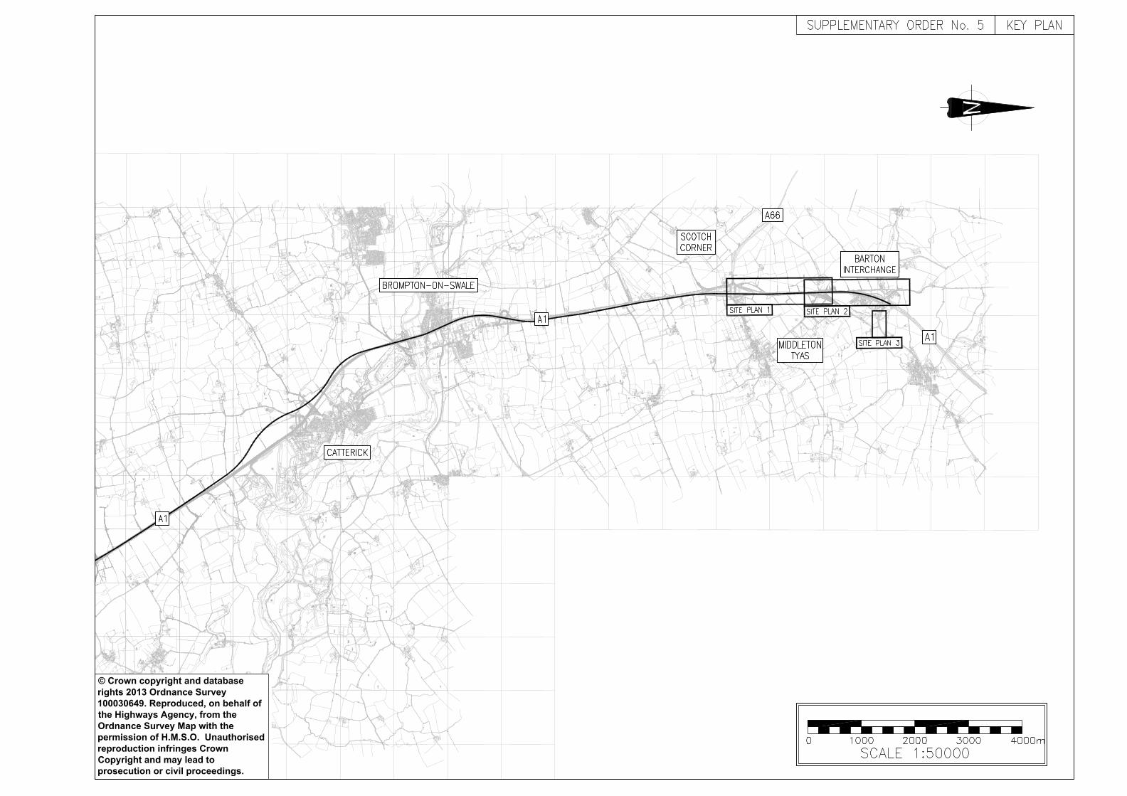
The Plan Folio Key Plan
Sheets 1 to 3

DEPARTMENT FOR TRANSPORT THE A1 MOTORWAY (DISHFORTH TO BARTON SECTION)
SUPPLEMENTARY COMPULSORY PURCHASE ORDER No.5 (No MP ..) 20.. The Secretary of State for Transport in exercise of his powers under sections 239, 240, 246 and 260 of the Highways Act 1980 as extended and supplemented by section 250 of that Act and under section 2 of the Acquisition of Land Act 1981 hereby makes the following Order:- 1.
(1) The Secretary of State is hereby authorised to purchase compulsorily for the purposes of:
a) the construction of special roads in the parishes of Middleton Tyas and Barton (in the
District of Richmondshire) in pursuance of the Motorway Scheme;
b) the construction and improvement of highways and the provision of new means of access to premises in those parishes and districts in pursuance of the Side Roads Orders;
c) use by the Secretary of State for Transport in connection with such construction and
improvement of highways and the execution of other works mentioned above;
d) the mitigation of any adverse effects which the existence or use of the highways proposed to be constructed or improved will have on their surroundings,
the land which is described in the Schedule to this Order and delineated and shown coloured pink on the plan and the rights described in that Schedule over the land described in it and delineated and coloured blue on the plan.
(2) Copies of the said Schemes and Orders (all with their accompanying plans) are
deposited along with the plan referred to in article 4. 2. In relation to the purchase authorised by this Order Parts II and III of Schedule 2 to the
Acquisition of Land Act 1981 are hereby incorporated with this Order subject to the modifications that references in those parts to the undertaking shall be construed as references to the land authorised to be purchased, or as the case may be, to the land over which rights are authorised to be purchased, and to any building or works constructed or to be constructed on it.
3. For the purpose of the provisions of Schedule 2 to the Acquisition of Land Act 1981, as
incorporated in this Order, the prescribed distance in relation to any seam of minerals lying under land adjoining the works to be constructed upon the land described in the Schedule to this Order shall be such a lateral distance from the said works on every side thereof as is
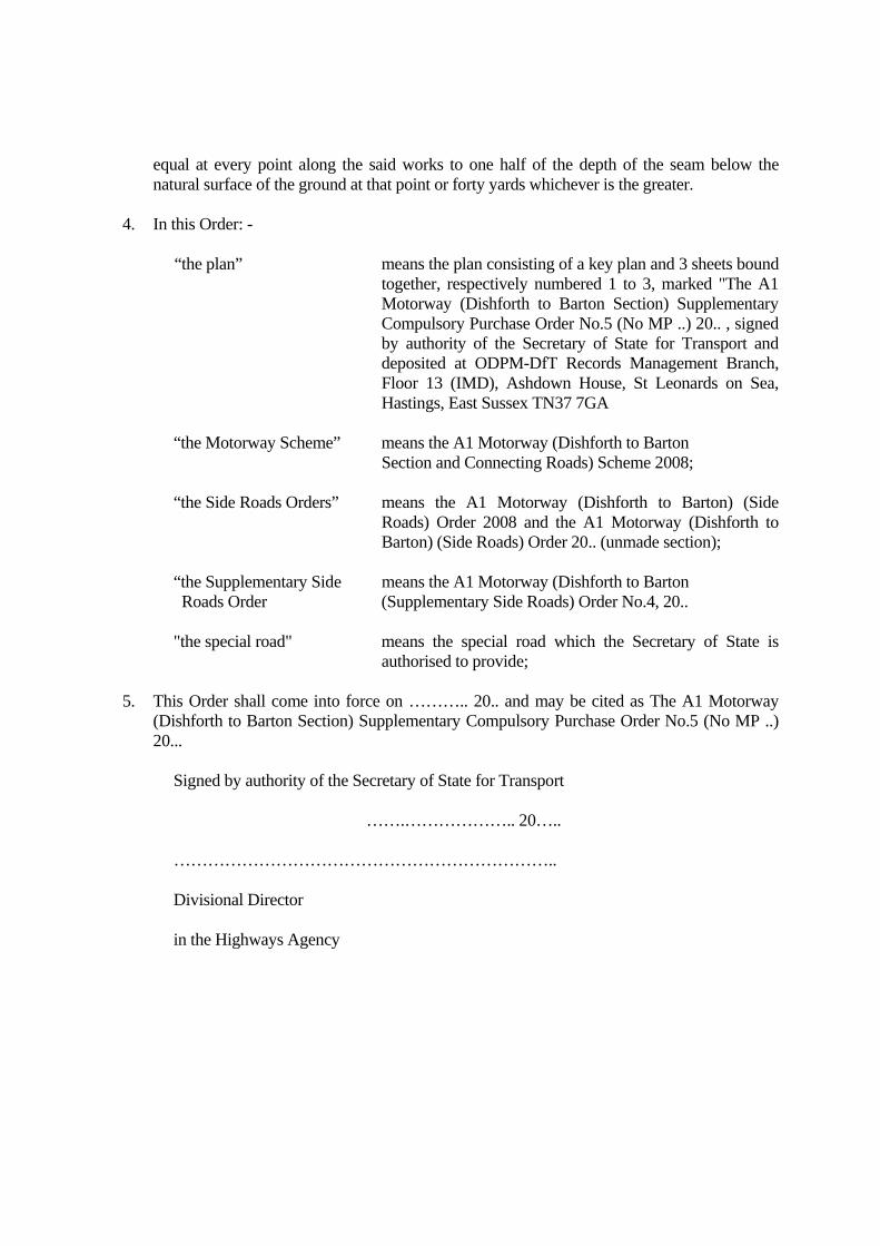
equal at every point along the said works to one half of the depth of the seam below the natural surface of the ground at that point or forty yards whichever is the greater.
4. In this Order: - “the plan” means the plan consisting of a key plan and 3 sheets bound
together, respectively numbered 1 to 3, marked "The A1 Motorway (Dishforth to Barton Section) Supplementary Compulsory Purchase Order No.5 (No MP ..) 20.. , signed by authority of the Secretary of State for Transport and deposited at ODPM-DfT Records Management Branch, Floor 13 (IMD), Ashdown House, St Leonards on Sea, Hastings, East Sussex TN37 7GA
“the Motorway Scheme” means the A1 Motorway (Dishforth to Barton
Section and Connecting Roads) Scheme 2008;
“the Side Roads Orders” means the A1 Motorway (Dishforth to Barton) (Side Roads) Order 2008 and the A1 Motorway (Dishforth to Barton) (Side Roads) Order 20.. (unmade section);
“the Supplementary Side means the A1 Motorway (Dishforth to Barton Roads Order (Supplementary Side Roads) Order No.4, 20.. "the special road" means the special road which the Secretary of State is
authorised to provide; 5. This Order shall come into force on ……….. 20.. and may be cited as The A1 Motorway
(Dishforth to Barton Section) Supplementary Compulsory Purchase Order No.5 (No MP ..) 20...
Signed by authority of the Secretary of State for Transport …….……………….. 20….. ………………………………………………………….. Divisional Director in the Highways Agency

EXPLANATORY NOTE (This note is not part of the Order)
This draft Supplementary Compulsory Purchase Order is to make provision for the further Compulsory Purchase of land and rights required for the scheme’s construction. Additional land will be required for the creation of highways, private means of access and modifications to the scheme layout in pursuance of the Secretaries of State Decision Letter of 31 March 2008 into further provision of a local access road between Scotch Corner and Barton.
Page 1 of 31
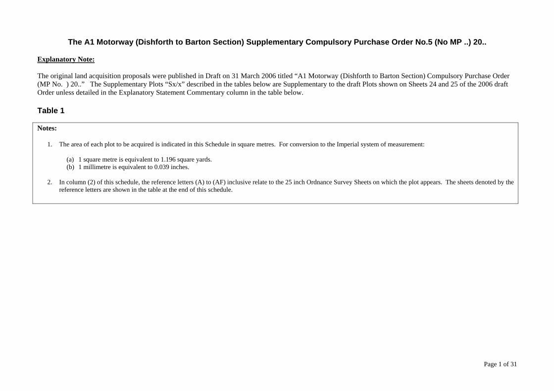
The A1 Motorway (Dishforth to Barton Section) Supplementary Compulsory Purchase Order No.5 (No MP ..) 20..
Explanatory Note: The original land acquisition proposals were published in Draft on 31 March 2006 titled “A1 Motorway (Dishforth to Barton Section) Compulsory Purchase Order (MP No. ) 20..” The Supplementary Plots “Sx/x” described in the tables below are Supplementary to the draft Plots shown on Sheets 24 and 25 of the 2006 draft Order unless detailed in the Explanatory Statement Commentary column in the table below. Table 1
Notes:
1. The area of each plot to be acquired is indicated in this Schedule in square metres. For conversion to the Imperial system of measurement:
(a) 1 square metre is equivalent to 1.196 square yards. (b) 1 millimetre is equivalent to 0.039 inches.
2. In column (2) of this schedule, the reference letters (A) to (AF) inclusive relate to the 25 inch Ordnance Survey Sheets on which the plot appears. The sheets denoted by the
reference letters are shown in the table at the end of this schedule.
Page 2 of 31
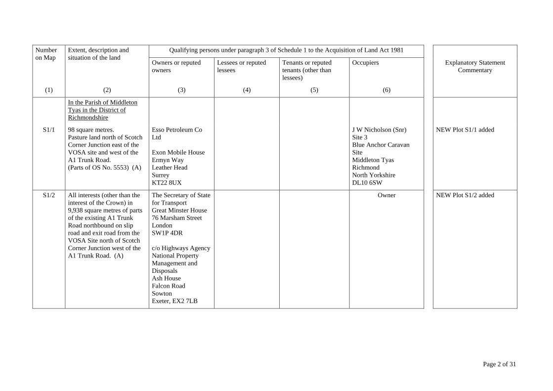
Number on Map
Extent, description and situation of the land
Qualifying persons under paragraph 3 of Schedule 1 to the Acquisition of Land Act 1981
Owners or reputed owners
Lessees or reputed lessees
Tenants or reputed tenants (other than lessees)
Occupiers Explanatory Statement Commentary
(1) (2) (3) (4) (5) (6)
In the Parish of Middleton Tyas in the District of Richmondshire
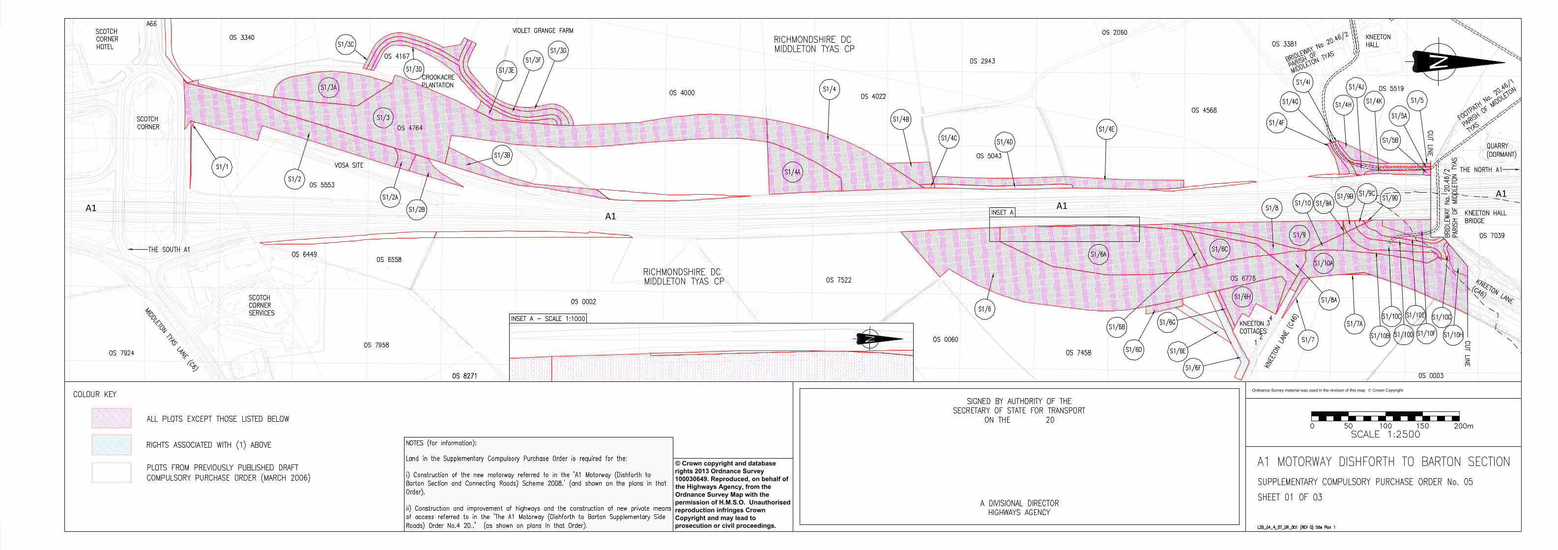
S1/1 98 square metres. Pasture land north of Scotch Corner Junction east of the VOSA site and west of the A1 Trunk Road. (Parts of OS No. 5553) (A)
Esso Petroleum Co Ltd Exon Mobile House Ermyn Way Leather Head Surrey KT22 8UX
J W Nicholson (Snr) Site 3 Blue Anchor Caravan Site Middleton Tyas Richmond North Yorkshire DL10 6SW
NEW Plot S1/1 added
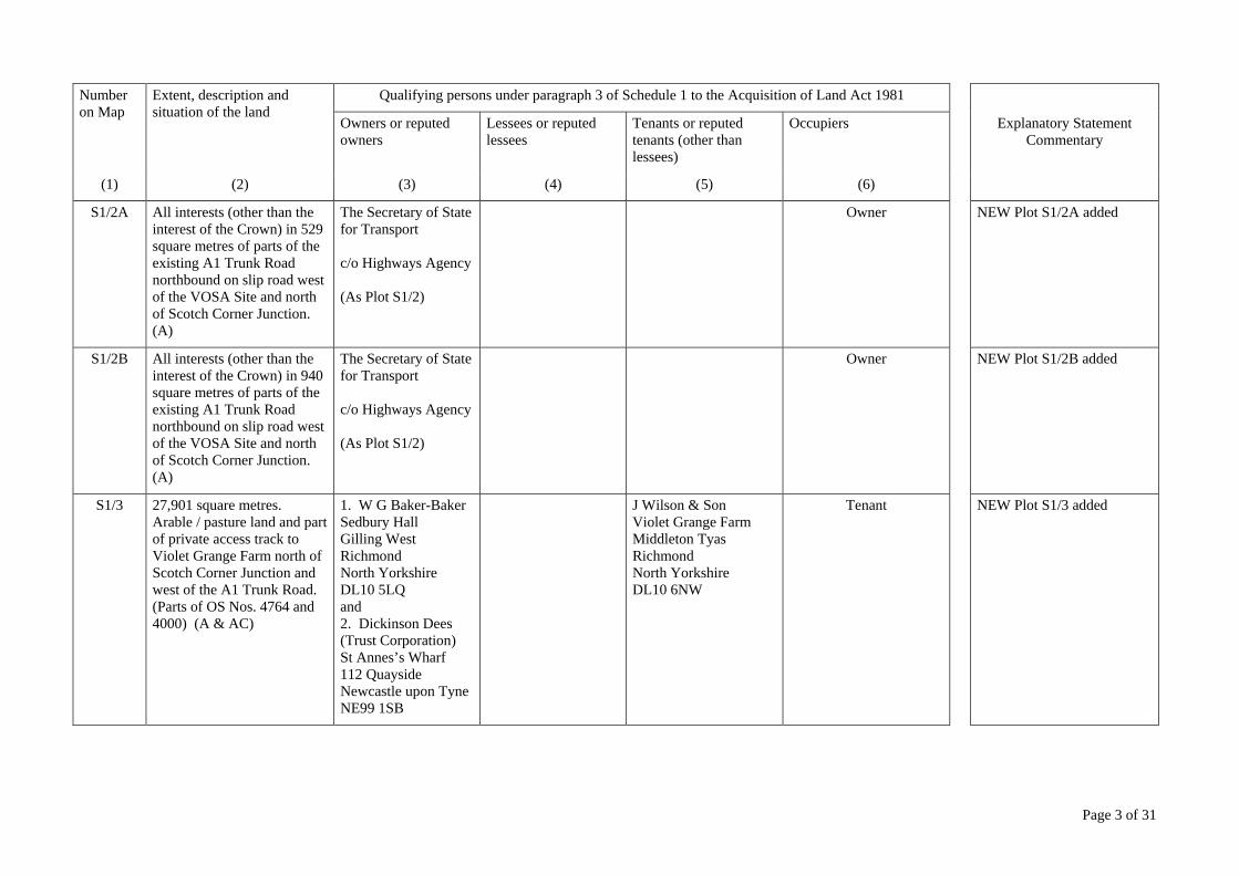
S1/2 All interests (other than the interest of the Crown) in 9,938 square metres of parts of the existing A1 Trunk Road northbound on slip road and exit road from the VOSA Site north of Scotch Corner Junction west of the A1 Trunk Road. (A)
The Secretary of State for Transport Great Minster House 76 Marsham Street London SW1P 4DR c/o Highways Agency National Property Management and Disposals Ash House Falcon Road Sowton Exeter, EX2 7LB
Owner NEW Plot S1/2 added
Page 3 of 31
Number on Map
Extent, description and situation of the land
Qualifying persons under paragraph 3 of Schedule 1 to the Acquisition of Land Act 1981
Owners or reputed owners
Lessees or reputed lessees
Tenants or reputed tenants (other than lessees)
Occupiers Explanatory Statement Commentary
(1) (2) (3) (4) (5) (6)
S1/2A All interests (other than the interest of the Crown) in 529 square metres of parts of the existing A1 Trunk Road northbound on slip road west of the VOSA Site and north of Scotch Corner Junction. (A)
The Secretary of State for Transport c/o Highways Agency (As Plot S1/2)
Owner NEW Plot S1/2A added
S1/2B All interests (other than the interest of the Crown) in 940 square metres of parts of the existing A1 Trunk Road northbound on slip road west of the VOSA Site and north of Scotch Corner Junction. (A)
The Secretary of State for Transport c/o Highways Agency (As Plot S1/2)
Owner NEW Plot S1/2B added
S1/3 27,901 square metres. Arable / pasture land and part of private access track to Violet Grange Farm north of Scotch Corner Junction and west of the A1 Trunk Road. (Parts of OS Nos. 4764 and 4000) (A & AC)
1. W G Baker-Baker Sedbury Hall Gilling West Richmond North Yorkshire DL10 5LQ and 2. Dickinson Dees (Trust Corporation) St Annes’s Wharf 112 Quayside Newcastle upon Tyne NE99 1SB
J Wilson & Son Violet Grange Farm Middleton Tyas Richmond North Yorkshire DL10 6NW
Tenant NEW Plot S1/3 added
Page 4 of 31
Number on Map
Extent, description and situation of the land
Qualifying persons under paragraph 3 of Schedule 1 to the Acquisition of Land Act 1981
Owners or reputed owners
Lessees or reputed lessees
Tenants or reputed tenants (other than lessees)
Occupiers Explanatory Statement Commentary
(1) (2) (3) (4) (5) (6)
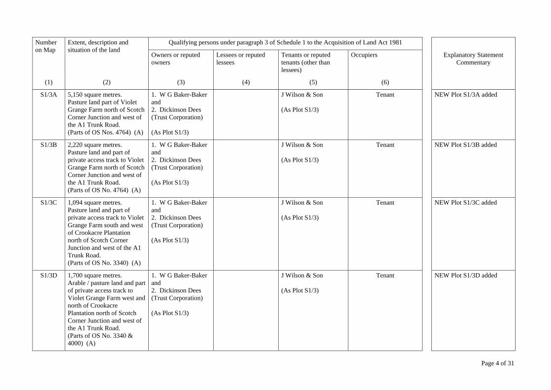
S1/3A 5,150 square metres. Pasture land part of Violet Grange Farm north of Scotch Corner Junction and west of the A1 Trunk Road. (Parts of OS Nos. 4764) (A)
1. W G Baker-Baker and 2. Dickinson Dees (Trust Corporation) (As Plot S1/3)
J Wilson & Son (As Plot S1/3)
Tenant NEW Plot S1/3A added
S1/3B 2,220 square metres. Pasture land and part of private access track to Violet Grange Farm north of Scotch Corner Junction and west of the A1 Trunk Road. (Parts of OS No. 4764) (A)
1. W G Baker-Baker and 2. Dickinson Dees (Trust Corporation) (As Plot S1/3)
J Wilson & Son (As Plot S1/3)
Tenant NEW Plot S1/3B added
S1/3C 1,094 square metres. Pasture land and part of private access track to Violet Grange Farm south and west of Crookacre Plantation north of Scotch Corner Junction and west of the A1 Trunk Road. (Parts of OS No. 3340) (A)
1. W G Baker-Baker and 2. Dickinson Dees (Trust Corporation) (As Plot S1/3)
J Wilson & Son (As Plot S1/3)
Tenant NEW Plot S1/3C added
S1/3D 1,700 square metres. Arable / pasture land and part of private access track to Violet Grange Farm west and north of Crookacre Plantation north of Scotch Corner Junction and west of the A1 Trunk Road. (Parts of OS No. 3340 & 4000) (A)
1. W G Baker-Baker and 2. Dickinson Dees (Trust Corporation) (As Plot S1/3)
J Wilson & Son (As Plot S1/3)
Tenant NEW Plot S1/3D added
Page 5 of 31
Number on Map
Extent, description and situation of the land
Qualifying persons under paragraph 3 of Schedule 1 to the Acquisition of Land Act 1981
Owners or reputed owners
Lessees or reputed lessees
Tenants or reputed tenants (other than lessees)
Occupiers Explanatory Statement Commentary
(1) (2) (3) (4) (5) (6)
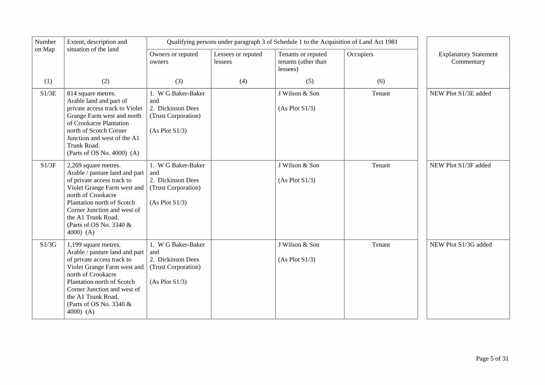
S1/3E 814 square metres. Arable land and part of private access track to Violet Grange Farm west and north of Crookacre Plantation north of Scotch Corner Junction and west of the A1 Trunk Road. (Parts of OS No. 4000) (A)
1. W G Baker-Baker and 2. Dickinson Dees (Trust Corporation) (As Plot S1/3)
J Wilson & Son (As Plot S1/3)
Tenant NEW Plot S1/3E added
S1/3F 2,269 square metres. Arable / pasture land and part of private access track to Violet Grange Farm west and north of Crookacre Plantation north of Scotch Corner Junction and west of the A1 Trunk Road. (Parts of OS No. 3340 & 4000) (A)
1. W G Baker-Baker and 2. Dickinson Dees (Trust Corporation) (As Plot S1/3)
J Wilson & Son (As Plot S1/3)
Tenant NEW Plot S1/3F added
S1/3G 1,199 square metres. Arable / pasture land and part of private access track to Violet Grange Farm west and north of Crookacre Plantation north of Scotch Corner Junction and west of the A1 Trunk Road. (Parts of OS No. 3340 & 4000) (A)
1. W G Baker-Baker and 2. Dickinson Dees (Trust Corporation) (As Plot S1/3)
J Wilson & Son (As Plot S1/3)
Tenant NEW Plot S1/3G added

Page 6 of 31
Number on Map
Extent, description and situation of the land
Qualifying persons under paragraph 3 of Schedule 1 to the Acquisition of Land Act 1981
Owners or reputed owners
Lessees or reputed lessees
Tenants or reputed tenants (other than lessees)
Occupiers Explanatory Statement Commentary
(1) (2) (3) (4) (5) (6)
S1/4 8,241 square metres. Arable / pasture land on the west of the A1 Trunk Road and north of Scotch Corner Junction. (Part of OS No. 4022) (AC)
W G Baker-Baker (As Plot S1/3)
1. A J Spier and 2. R Congreve both of Murky Hill Farm Cow Lane Middleton Tyas Richmond North Yorkshire DL10 6RW
Tenants NEW Plot S1/4 added
S1/4A 4,600 square metres. Arable / pasture land on the west of the A1 Trunk Road and north of Scotch Corner Junction. (Part of OS No. 4022) (AC)
W G Baker-Baker (As Plot S1/3)
1. A J Spier and 2. R Congreve (As Plot S1/4)
Tenants NEW Plot S1/4A added
S1/4B 1,164 square metres. Arable / pasture land on the west of the A1 Trunk Road and north of Scotch Corner Junction. (Part of OS No. 4022) (AC)
W G Baker-Baker (As Plot S1/3)
1. A J Spier and 2. R Congreve (As Plot S1/4)
Tenants NEW Plot S1/4B added
S1/4C 89 square metres. Arable / pasture land on the west of the A1 Trunk Road and north of Scotch Corner Junction. (Part of OS No. 4022) (AC)
W G Baker-Baker (As Plot S1/3)
1. A J Spier and 2. R Congreve (As Plot S1/4)
Tenants NEW Plot S1/4C added

Page 7 of 31
Number on Map
Extent, description and situation of the land
Qualifying persons under paragraph 3 of Schedule 1 to the Acquisition of Land Act 1981
Owners or reputed owners
Lessees or reputed lessees
Tenants or reputed tenants (other than lessees)
Occupiers Explanatory Statement Commentary
(1) (2) (3) (4) (5) (6)
S1/4D The right to lay and maintain 186 linear metres of 450 mm diameter pipe drain in 930 square metres of arable / pasture land on the west of the A1 Trunk Road and north of Scotch Corner Junction. (Part of OS No. 5043) (AC)
W G Baker-Baker (As Plot S1/3)
1. A J Spier and 2. R Congreve (As Plot S1/4)
Tenants NEW Plot S1/4D added
S1/4E 3,838 square metres. Arable / pasture land on the west of the A1 Trunk Road and north of Scotch Corner Junction. (Part of OS Nos. 5043 & 4568) (AC)
W G Baker-Baker (As Plot S1/3)
1. A J Spier and 2. R Congreve (As Plot S1/4)
Tenants NEW Plot S1/4E added
S1/4F 331 square metres. Arable / pasture land and part of private access to Kneeton Hall and parts of Bridleway No 20.16/2 (Parish of Middleton Tyas) on the west of the A1 Trunk Road east of Kneeton Hall. (Part of OS No. 5519) (AC)
W G Baker-Baker (As Plot S1/3)
1. A J Spier and 2. R Congreve (As Plot S1/4)
Tenants NEW Plot S1/4F added
Page 8 of 31
Number on Map
Extent, description and situation of the land
Qualifying persons under paragraph 3 of Schedule 1 to the Acquisition of Land Act 1981
Owners or reputed owners
Lessees or reputed lessees
Tenants or reputed tenants (other than lessees)
Occupiers Explanatory Statement Commentary
(1) (2) (3) (4) (5) (6)
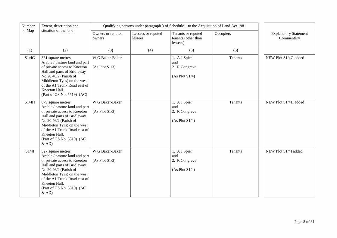
S1/4G 361 square metres. Arable / pasture land and part of private access to Kneeton Hall and parts of Bridleway No 20.46/2 (Parish of Middleton Tyas) on the west of the A1 Trunk Road east of Kneeton Hall. (Part of OS No. 5519) (AC)
W G Baker-Baker (As Plot S1/3)
1. A J Spier and 2. R Congreve (As Plot S1/4)
Tenants NEW Plot S1/4G added
S1/4H 679 square metres. Arable / pasture land and part of private access to Kneeton Hall and parts of Bridleway No 20.46/2 (Parish of Middleton Tyas) on the west of the A1 Trunk Road east of Kneeton Hall. (Part of OS No. 5519) (AC & AD)
W G Baker-Baker (As Plot S1/3)
1. A J Spier and 2. R Congreve (As Plot S1/4)
Tenants NEW Plot S1/4H added
S1/4I 527 square metres. Arable / pasture land and part of private access to Kneeton Hall and parts of Bridleway No 20.46/2 (Parish of Middleton Tyas) on the west of the A1 Trunk Road east of Kneeton Hall. (Part of OS No. 5519) (AC & AD)
W G Baker-Baker (As Plot S1/3)
1. A J Spier and 2. R Congreve (As Plot S1/4)
Tenants NEW Plot S1/4I added

Page 9 of 31
Number on Map
Extent, description and situation of the land
Qualifying persons under paragraph 3 of Schedule 1 to the Acquisition of Land Act 1981
Owners or reputed owners
Lessees or reputed lessees
Tenants or reputed tenants (other than lessees)
Occupiers Explanatory Statement Commentary
(1) (2) (3) (4) (5) (6)
S1/4J 695 square metres. Arable / pasture land and part of private access to Kneeton Hall and parts of Bridleway No 20.46/2 (Parish of Middleton Tyas) on the west of the A1 Trunk Road east of Kneeton Hall. (Part of OS No. 5519) (AC & AD)
W G Baker-Baker (As Plot S1/3)
1. A J Spier and 2. R Congreve (As Plot S1/4)
Tenants NEW Plot S1/4J added
S1/4K 387 square metres. Arable / pasture land and part of private access to Kneeton Hall and parts of Bridleway No 20.46/2 (Parish of Middleton Tyas) on the west of the A1 Trunk Road east of Kneeton Hall. (Part of OS No. 5519) (AC & AD)
W G Baker-Baker (As Plot S1/3)
1. A J Spier and 2. R Congreve (As Plot S1/4)
Tenants NEW Plot S1/4K added
S1/5 All interests (other than the interest of the Crown) in 40 square metres of part of private access to Kneeton Hall and parts of Bridleway No 20.46/2 (Parish of Middleton Tyas) on the west of the A1 Trunk Road east of Kneeton Hall. (Part of OS No. 5519) (AD)
The Secretary of State for Transport c/o Highways Agency (As Plot S1/2)
DELETED - Draft 2006 CPO Sheet 25, Plot 25/1 REPLACED with NEW CPO Plot S1/5

Page 10 of 31
Number on Map
Extent, description and situation of the land
Qualifying persons under paragraph 3 of Schedule 1 to the Acquisition of Land Act 1981
Owners or reputed owners
Lessees or reputed lessees
Tenants or reputed tenants (other than lessees)
Occupiers Explanatory Statement Commentary
(1) (2) (3) (4) (5) (6)
S1/5A All interests (other than the interest of the Crown) in 44 square metres of part of private access to Kneeton Hall and parts of Bridleway No 20.46/2 (Parish of Middleton Tyas) on the west of the A1 Trunk Road east of Kneeton Hall. (Part of OS No. 5519) (AD)
The Secretary of State for Transport c/o Highways Agency (As Plot S1/2)
DELETED - Draft 2006 CPO Sheet 25, Plot 25/1 REPLACED with NEW CPO Plot S1/5A
S1/5B All interests (other than the interest of the Crown) in 72 square metres of parts of private access to Kneeton Hall and parts of Bridleway No 20.46/2 (Parish of Middleton Tyas) on the west of the A1 Trunk Road east of Kneeton Hall. (Part of OS No. 5519) (AD)
The Secretary of State for Transport c/o Highways Agency (As Plot S1/2)
DELETED - Draft 2006 CPO Sheet 25, Plot 25/1 REPLACED with NEW CPO Plot S1/5B
S1/6 25,238 square metres. Arable / pasture land on the east of the A1 Trunk Road and on the south of Kneeton Lane (C46) (Part of OS Nos. 7458 & 6776) (AC)
W G Baker-Baker (As Plot S1/3)
1. A J Spier and 2. R Congreve (As Plot S1/4)
Tenants NEW Plot S1/6 added
S1/6A 14,168 square metres. Arable land on the east of the A1 Trunk Road and on the south of Kneeton Lane (C46) (Part of OS No. 7458) (AC)
W G Baker-Baker (As Plot S1/3)
1. A J Spier and 2. R Congreve (As Plot S1/4)
Tenants NEW Plot S1/6A added

Page 11 of 31
Number on Map
Extent, description and situation of the land
Qualifying persons under paragraph 3 of Schedule 1 to the Acquisition of Land Act 1981
Owners or reputed owners
Lessees or reputed lessees
Tenants or reputed tenants (other than lessees)
Occupiers Explanatory Statement Commentary
(1) (2) (3) (4) (5) (6)
S1/6B 541 square metres. Arable / pasture land and parts of ditch on the east of the A1 Trunk Road and on the southwest of Kneeton Cottages. (Part of OS Nos. 7458 & 6776) (AC)
W G Baker-Baker (As Plot S1/3)
1. A J Spier and 2. R Congreve (As Plot S1/4)
Tenants NEW Plot S1/6B added
S1/6C 2,537 square metres. Arable / pasture land and parts of ditch on the east of the A1 Trunk Road and on the southwest of Kneeton Cottages. (Part of OS No. 6776) (AC)
W G Baker-Baker (As Plot S1/3)
1. A J Spier and 2. R Congreve (As Plot S1/4)
Tenants NEW Plot S1/6C added
S1/6D 478 square metres. Arable land on the east of the A1 Trunk Road and on the south of Kneeton Cottages. (Part of OS No. 7458) (AC)
W G Baker-Baker (As Plot S1/3)
1. A J Spier and 2. R Congreve (As Plot S1/4)
Tenants NEW Plot S1/6D added
S1/6E The right to lay and maintain 74 linear metres of 300 mm diameter pipe drain and the right to construct and maintain a culvert headwall, all in 768 square metres of arable land on the east of the A1 Trunk Road and south of Kneeton Cottages. (Part of OS No. 7458) (AC)
W G Baker-Baker (As Plot S1/3)
1. A J Spier and 2. R Congreve (As Plot S1/4)
Tenants NEW Plot S1/6E added
Page 12 of 31
Number on Map
Extent, description and situation of the land
Qualifying persons under paragraph 3 of Schedule 1 to the Acquisition of Land Act 1981
Owners or reputed owners
Lessees or reputed lessees
Tenants or reputed tenants (other than lessees)
Occupiers Explanatory Statement Commentary
(1) (2) (3) (4) (5) (6)
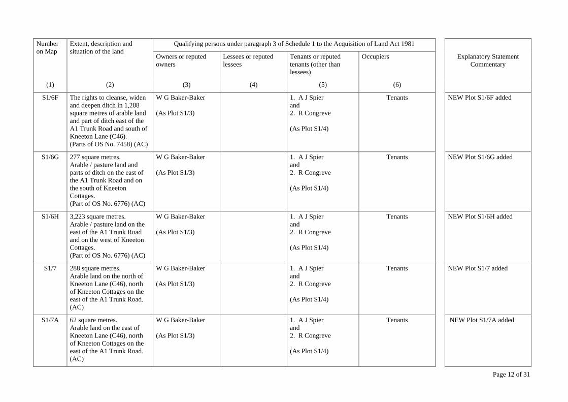
S1/6F The rights to cleanse, widen and deepen ditch in 1,288 square metres of arable land and part of ditch east of the A1 Trunk Road and south of Kneeton Lane (C46). (Parts of OS No. 7458) (AC)
W G Baker-Baker (As Plot S1/3)
1. A J Spier and 2. R Congreve (As Plot S1/4)
Tenants NEW Plot S1/6F added
S1/6G 277 square metres. Arable / pasture land and parts of ditch on the east of the A1 Trunk Road and on the south of Kneeton Cottages. (Part of OS No. 6776) (AC)
W G Baker-Baker (As Plot S1/3)
1. A J Spier and 2. R Congreve (As Plot S1/4)
Tenants NEW Plot S1/6G added
S1/6H 3,223 square metres. Arable / pasture land on the east of the A1 Trunk Road and on the west of Kneeton Cottages. (Part of OS No. 6776) (AC)
W G Baker-Baker (As Plot S1/3)
1. A J Spier and 2. R Congreve (As Plot S1/4)
Tenants NEW Plot S1/6H added
S1/7 288 square metres. Arable land on the north of Kneeton Lane (C46), north of Kneeton Cottages on the east of the A1 Trunk Road. (AC)
W G Baker-Baker (As Plot S1/3)
1. A J Spier and 2. R Congreve (As Plot S1/4)
Tenants NEW Plot S1/7 added
S1/7A 62 square metres. Arable land on the east of Kneeton Lane (C46), north of Kneeton Cottages on the east of the A1 Trunk Road. (AC)
W G Baker-Baker (As Plot S1/3)
1. A J Spier and 2. R Congreve (As Plot S1/4)
Tenants NEW Plot S1/7A added
Page 13 of 31
Number on Map
Extent, description and situation of the land
Qualifying persons under paragraph 3 of Schedule 1 to the Acquisition of Land Act 1981
Owners or reputed owners
Lessees or reputed lessees
Tenants or reputed tenants (other than lessees)
Occupiers Explanatory Statement Commentary
(1) (2) (3) (4) (5) (6)
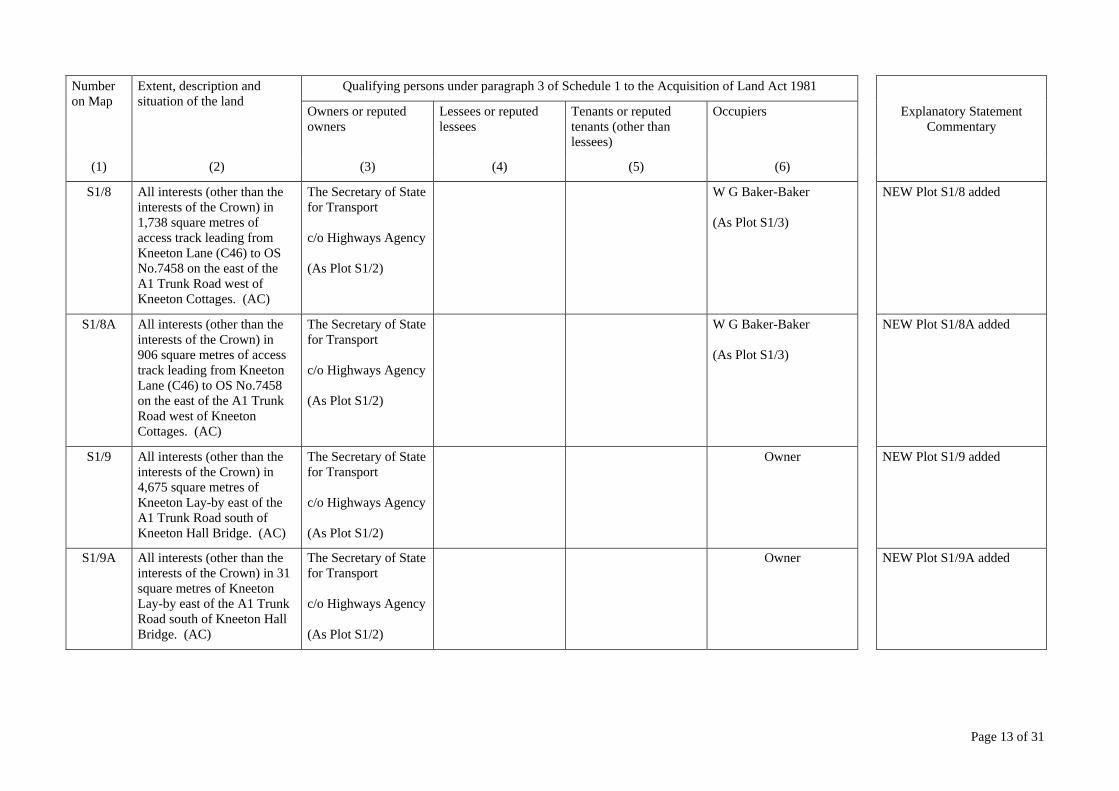
S1/8 All interests (other than the interests of the Crown) in 1,738 square metres of access track leading from Kneeton Lane (C46) to OS No.7458 on the east of the A1 Trunk Road west of Kneeton Cottages. (AC)
The Secretary of State for Transport c/o Highways Agency (As Plot S1/2)
W G Baker-Baker (As Plot S1/3)
NEW Plot S1/8 added
S1/8A All interests (other than the interests of the Crown) in 906 square metres of access track leading from Kneeton Lane (C46) to OS No.7458 on the east of the A1 Trunk Road west of Kneeton Cottages. (AC)
The Secretary of State for Transport c/o Highways Agency (As Plot S1/2)
W G Baker-Baker (As Plot S1/3)
NEW Plot S1/8A added
S1/9 All interests (other than the interests of the Crown) in 4,675 square metres of Kneeton Lay-by east of the A1 Trunk Road south of Kneeton Hall Bridge. (AC)
The Secretary of State for Transport c/o Highways Agency (As Plot S1/2)
Owner NEW Plot S1/9 added
S1/9A All interests (other than the interests of the Crown) in 31 square metres of Kneeton Lay-by east of the A1 Trunk Road south of Kneeton Hall Bridge. (AC)
The Secretary of State for Transport c/o Highways Agency (As Plot S1/2)
Owner NEW Plot S1/9A added

Page 14 of 31
Number on Map
Extent, description and situation of the land
Qualifying persons under paragraph 3 of Schedule 1 to the Acquisition of Land Act 1981
Owners or reputed owners
Lessees or reputed lessees
Tenants or reputed tenants (other than lessees)
Occupiers Explanatory Statement Commentary
(1) (2) (3) (4) (5) (6)
S1/9B All interests (other than the interests of the Crown) in 201 square metres of Kneeton Lay-by east of the A1 Trunk Road south of Kneeton Hall Bridge. (AC)
The Secretary of State for Transport c/o Highways Agency (As Plot S1/2)
Owner NEW Plot S1/9B added
S1/9C All interests (other than the interests of the Crown) in 92 square metres of Kneeton Lay-by east of the A1 Trunk Road south of Kneeton Hall Bridge. (AC)
The Secretary of State for Transport c/o Highways Agency (As Plot S1/2)
Owner NEW Plot S1/9C added
S1/9D All interests (other than the interests of the Crown) in 28 square metres of Kneeton Lay-by east of the A1 Trunk Road south of Kneeton Hall Bridge. (AC)
The Secretary of State for Transport c/o Highways Agency (As Plot S1/2)
Owner NEW Plot S1/9D added
S1/10 All interests (other than the interests of the Crown) in 528 square metres of parts of Kneeton Lane (C46) east of the A1 Trunk Road. (AC & AD)
The Secretary of State for Transport c/o Highways Agency (As Plot S1/2)
North Yorkshire County Council County Hall Northallerton North Yorkshire DL7 8AD (as Highways Authority)
NEW Plot S1/10 added
Page 15 of 31
Number on Map
Extent, description and situation of the land
Qualifying persons under paragraph 3 of Schedule 1 to the Acquisition of Land Act 1981
Owners or reputed owners
Lessees or reputed lessees
Tenants or reputed tenants (other than lessees)
Occupiers Explanatory Statement Commentary
(1) (2) (3) (4) (5) (6)
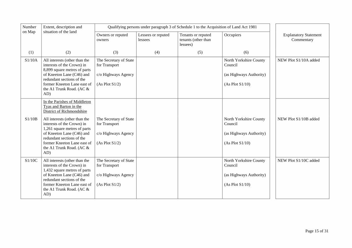
S1/10A All interests (other than the interests of the Crown) in 8,899 square metres of parts of Kneeton Lane (C46) and redundant sections of the former Kneeton Lane east of the A1 Trunk Road. (AC & AD)
The Secretary of State for Transport c/o Highways Agency (As Plot S1/2)
North Yorkshire County Council (as Highways Authority) (As Plot S1/10)
NEW Plot S1/10A added
In the Parishes of Middleton Tyas and Barton in the District of Richmondshire
S1/10B All interests (other than the interests of the Crown) in 1,261 square metres of parts of Kneeton Lane (C46) and redundant sections of the former Kneeton Lane east of the A1 Trunk Road. (AC & AD)
The Secretary of State for Transport c/o Highways Agency (As Plot S1/2)
North Yorkshire County Council (as Highways Authority) (As Plot S1/10)
NEW Plot S1/10B added
S1/10C All interests (other than the interests of the Crown) in 1,432 square metres of parts of Kneeton Lane (C46) and redundant sections of the former Kneeton Lane east of the A1 Trunk Road. (AC & AD)
The Secretary of State for Transport c/o Highways Agency (As Plot S1/2)
North Yorkshire County Council (as Highways Authority) (As Plot S1/10)
NEW Plot S1/10C added
Page 16 of 31
Number on Map
Extent, description and situation of the land
Qualifying persons under paragraph 3 of Schedule 1 to the Acquisition of Land Act 1981
Owners or reputed owners
Lessees or reputed lessees
Tenants or reputed tenants (other than lessees)
Occupiers Explanatory Statement Commentary
(1) (2) (3) (4) (5) (6)
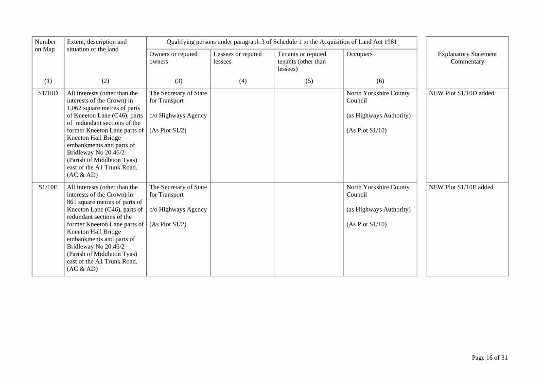
S1/10D All interests (other than the interests of the Crown) in 1,062 square metres of parts of Kneeton Lane (C46), parts of redundant sections of the former Kneeton Lane parts of Kneeton Hall Bridge embankments and parts of Bridleway No 20.46/2 (Parish of Middleton Tyas) east of the A1 Trunk Road. (AC & AD)
The Secretary of State for Transport c/o Highways Agency (As Plot S1/2)
North Yorkshire County Council (as Highways Authority) (As Plot S1/10)
NEW Plot S1/10D added
S1/10E All interests (other than the interests of the Crown) in 861 square metres of parts of Kneeton Lane (C46), parts of redundant sections of the former Kneeton Lane parts of Kneeton Hall Bridge embankments and parts of Bridleway No 20.46/2 (Parish of Middleton Tyas) east of the A1 Trunk Road. (AC & AD)
The Secretary of State for Transport c/o Highways Agency (As Plot S1/2)
North Yorkshire County Council (as Highways Authority) (As Plot S1/10)
NEW Plot S1/10E added
Page 17 of 31
Number on Map
Extent, description and situation of the land
Qualifying persons under paragraph 3 of Schedule 1 to the Acquisition of Land Act 1981
Owners or reputed owners
Lessees or reputed lessees
Tenants or reputed tenants (other than lessees)
Occupiers Explanatory Statement Commentary
(1) (2) (3) (4) (5) (6)
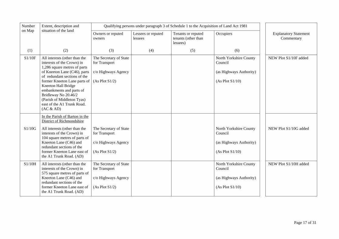
S1/10F All interests (other than the interests of the Crown) in 1,286 square metres of parts of Kneeton Lane (C46), parts of redundant sections of the former Kneeton Lane parts of Kneeton Hall Bridge embankments and parts of Bridleway No 20.46/2 (Parish of Middleton Tyas) east of the A1 Trunk Road. (AC & AD)
The Secretary of State for Transport c/o Highways Agency (As Plot S1/2)
North Yorkshire County Council (as Highways Authority) (As Plot S1/10)
NEW Plot S1/10F added
In the Parish of Barton in the District of Richmondshire
S1/10G All interests (other than the interests of the Crown) in 104 square metres of parts of Kneeton Lane (C46) and redundant sections of the former Kneeton Lane east of the A1 Trunk Road. (AD)
The Secretary of State for Transport c/o Highways Agency (As Plot S1/2)
North Yorkshire County Council (as Highways Authority) (As Plot S1/10)
NEW Plot S1/10G added
S1/10H All interests (other than the interests of the Crown) in 575 square metres of parts of Kneeton Lane (C46) and redundant sections of the former Kneeton Lane east of the A1 Trunk Road. (AD)
The Secretary of State for Transport c/o Highways Agency (As Plot S1/2)
North Yorkshire County Council (as Highways Authority) (As Plot S1/10)
NEW Plot S1/10H added
Page 18 of 31
Number on Map
Extent, description and situation of the land
Qualifying persons under paragraph 3 of Schedule 1 to the Acquisition of Land Act 1981
Owners or reputed owners
Lessees or reputed lessees
Tenants or reputed tenants (other than lessees)
Occupiers Explanatory Statement Commentary
(1) (2) (3) (4) (5) (6)
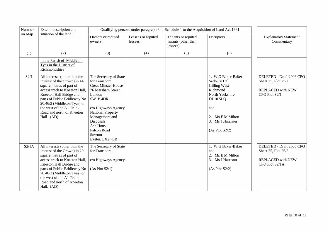
In the Parish of Middleton Tyas in the District of Richmondshire
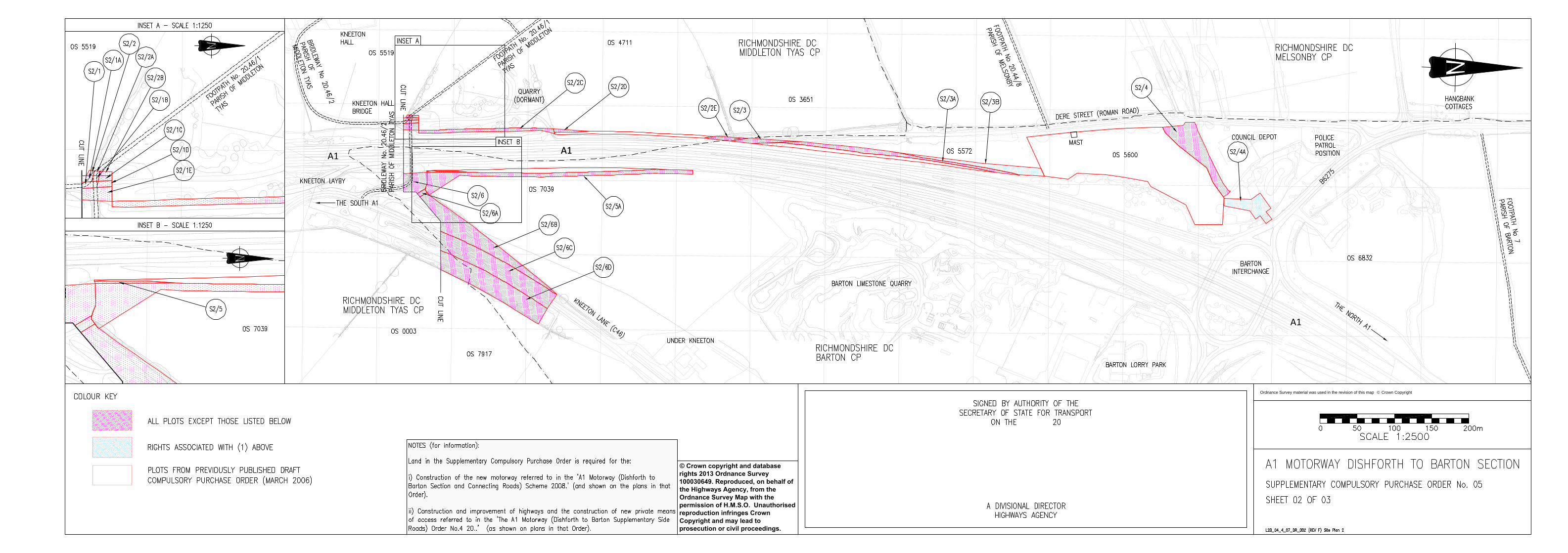
S2/1 All interests (other than the interest of the Crown) in 44 square metres of part of access track to Kneeton Hall, Kneeton Hall Bridge and parts of Public Bridleway No 20.46/2 (Middleton Tyas) on the west of the A1 Trunk Road and north of Kneeton Hall. (AD)
The Secretary of State for Transport Great Minster House 76 Marsham Street London SW1P 4DR c/o Highways Agency National Property Management and Disposals Ash House Falcon Road Sowton Exeter, EX2 7LB
1. W G Baker-Baker Sedbury Hall Gilling West Richmond North Yorkshire DL10 5LQ and 2. Ms E M Milton 3. Ms J Harrison (As Plot S2/2)
DELETED - Draft 2006 CPO Sheet 25, Plot 25/2 REPLACED with NEW CPO Plot S2/1
S2/1A All interests (other than the interest of the Crown) in 29 square metres of part of access track to Kneeton Hall, Kneeton Hall Bridge and parts of Public Bridleway No 20.46/2 (Middleton Tyas) on the west of the A1 Trunk Road and north of Kneeton Hall. (AD)
The Secretary of State for Transport c/o Highways Agency (As Plot S2/1)
1. W G Baker-Baker and 2. Ms E M Milton 3. Ms J Harrison (As Plot S2/2)
DELETED - Draft 2006 CPO Sheet 25, Plot 25/2 REPLACED with NEW CPO Plot S2/1A
Page 19 of 31
Number on Map
Extent, description and situation of the land
Qualifying persons under paragraph 3 of Schedule 1 to the Acquisition of Land Act 1981
Owners or reputed owners
Lessees or reputed lessees
Tenants or reputed tenants (other than lessees)
Occupiers Explanatory Statement Commentary
(1) (2) (3) (4) (5) (6)
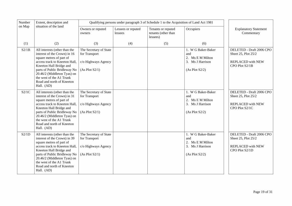
S2/1B All interests (other than the interest of the Crown) in 16 square metres of part of access track to Kneeton Hall, Kneeton Hall Bridge and parts of Public Bridleway No 20.46/2 (Middleton Tyas) on the west of the A1 Trunk Road and north of Kneeton Hall. (AD)
The Secretary of State for Transport c/o Highways Agency (As Plot S2/1)
1. W G Baker-Baker and 2. Ms E M Milton 3. Ms J Harrison (As Plot S2/2)
DELETED - Draft 2006 CPO Sheet 25, Plot 25/2 REPLACED with NEW CPO Plot S2/1B
S2/1C All interests (other than the interest of the Crown) in 31 square metres of part of access track to Kneeton Hall, Kneeton Hall Bridge and parts of Public Bridleway No 20.46/2 (Middleton Tyas) on the west of the A1 Trunk Road and north of Kneeton Hall. (AD)
The Secretary of State for Transport c/o Highways Agency (As Plot S2/1)
1. W G Baker-Baker and 2. Ms E M Milton 3. Ms J Harrison (As Plot S2/2)
DELETED - Draft 2006 CPO Sheet 25, Plot 25/2 REPLACED with NEW CPO Plot S2/1C
S2/1D All interests (other than the interest of the Crown) in 39 square metres of part of access track to Kneeton Hall, Kneeton Hall Bridge and parts of Public Bridleway No 20.46/2 (Middleton Tyas) on the west of the A1 Trunk Road and north of Kneeton Hall. (AD)
The Secretary of State for Transport c/o Highways Agency (As Plot S2/1)
1. W G Baker-Baker and 2. Ms E M Milton 3. Ms J Harrison (As Plot S2/2)
DELETED - Draft 2006 CPO Sheet 25, Plot 25/2 REPLACED with NEW CPO Plot S2/1D

Page 20 of 31
Number on Map
Extent, description and situation of the land
Qualifying persons under paragraph 3 of Schedule 1 to the Acquisition of Land Act 1981
Owners or reputed owners
Lessees or reputed lessees
Tenants or reputed tenants (other than lessees)
Occupiers Explanatory Statement Commentary
(1) (2) (3) (4) (5) (6)
S2/1E All interests (other than the interest of the Crown) in 180 square metres of part of access track to Kneeton Hall, Kneeton Hall Bridge and parts of Public Bridleway No 20.46/2 (Middleton Tyas) on the west of the A1 Trunk Road and north of Kneeton Hall. (AD)
The Secretary of State for Transport c/o Highways Agency (As Plot S2/1)
1. W G Baker-Baker and 2. Ms E M Milton 3. Ms J Harrison (As Plot S2/2)
DELETED - Draft 2006 CPO Sheet 25, Plot 25/2 REPLACED with NEW CPO Plot S2/1E
S2/2 14 square metres. Part of Quarry (dormant) on the west of the A1 Trunk Road and north of Kneeton Hall Bridge. (AD)
1. Ms E M Milton 27 Ronaldshay Drive Richmond North Yorkshire DL10 5BN and 2. Ms J Harrison Hamewith House Middleton Tyas Richmond North Yorkshire DL10 6PE
Sherburn Stone Co Ltd 15 Front Street Sherburn Hill Durham DH6 1PA
Lessee DELETED - Draft 2006 CPO Sheet 25, Plot 25/2 REPLACED with NEW CPO Plot S2/2
S2/2A 13 square metres. Part of Quarry (dormant) and parts of and Public Footpath No 20.46/1 (Middleton Tyas) on the west of the A1 Trunk Road and north of Kneeton Hall Bridge. (AD)
1. Ms E M Milton and 2. Ms J Harrison (As Plot S2/2)
Sherburn Stone Co Ltd (As Plot S2/2)
Lessee DELETED - Draft 2006 CPO Sheet 25, Plot 25/2 REPLACED with NEW CPO Plot S2/2B

Page 21 of 31
Number on Map
Extent, description and situation of the land
Qualifying persons under paragraph 3 of Schedule 1 to the Acquisition of Land Act 1981
Owners or reputed owners
Lessees or reputed lessees
Tenants or reputed tenants (other than lessees)
Occupiers Explanatory Statement Commentary
(1) (2) (3) (4) (5) (6)
S2/2B 25 square metres. Part of Quarry (dormant) on the west of the A1 Trunk Road and north of Kneeton Hall Bridge. (AD)
1. Ms E M Milton and 2. Ms J Harrison (As Plot S2/2)
Sherburn Stone Co Ltd (As Plot S2/2)
Lessee DELETED - Draft 2006 CPO Sheet 25, Plot 25/2 REPLACED with NEW CPO Plot S2/2B
S2/2C 741 square metres. Part of Quarry (dormant) on the west of the A1 Trunk Road and north of Kneeton Hall Bridge. (AD)
1. Ms E M Milton and 2. Ms J Harrison (As Plot S2/2)
Sherburn Stone Co Ltd (As Plot S2/2)
Lessee DELETED - Draft 2006 CPO Sheet 25, Plot 25/2 REPLACED with NEW CPO Plot S2/2C
S2/2D 119 square metres. Part of Quarry (dormant) on the west of the A1 Trunk Road and north of Kneeton Hall Bridge. (AD)
1. Ms E M Milton and 2. Ms J Harrison (As Plot S2/2)
Sherburn Stone Co Ltd (As Plot S2/2)
Lessee DELETED - Draft 2006 CPO Sheet 25, Plot 25/3A REPLACED with NEW CPO Plot S2/2D
In the Parishes of Middleton Tyas and Barton in the District of Richmondshire
S2/2E 205 square metres. Part of Dere Street (Roman Road) on the west of the A1 Trunk Road and north of Kneeton Hall Bridge. (AD)
1. Ms E M Milton and 2. Ms J Harrison (As Plot S2/2)
Owner NEW Plot S2/2E added

Page 22 of 31
Number on Map
Extent, description and situation of the land
Qualifying persons under paragraph 3 of Schedule 1 to the Acquisition of Land Act 1981
Owners or reputed owners
Lessees or reputed lessees
Tenants or reputed tenants (other than lessees)
Occupiers Explanatory Statement Commentary
(1) (2) (3) (4) (5) (6)
In the Parish of Barton in the District of Richmondshire
S2/3 338 square metres. Part of Dere Street (Roman Road) on the west of the A1 Trunk Road and north of Kneeton Hall Bridge. (AD)
J E Beadle Carlton Hall Carlton Aldbrough St. John Richmond North Yorkshire DL11 7AJ
Owner NEW Plot S2/3 added
S2/3A 1,267 square metres. Woodland on the west of the A1 Trunk Road and south west of Barton Interchange. (Part of OS No. 5572) (AD)
J E Beadle (As Plot S2/3)
Owner NEW Plot S2/3A added
S2/3B The rights to lay and maintain 203 linear metres of 750 mm diameter pipe drain in 1,062 square metres of woodland on the west of the A1 Trunk Road and south west of Barton Interchange. (Part of OS No. 5572) (AD)
J E Beadle (As Plot S2/3)
Owner NEW Plot S2/3B added
S2/4 2,310 square metres. Parts of woodland and scrubland south of the Council Depot and west of the A1 Trunk Road. (Part of OS No. 5600) (AE)
T B Tarn Middlestone Grange Middlestone Bishop Auckland Co Durham DL14 8DW
Owner NEW Plot S2/4 added
Page 23 of 31
Number on Map
Extent, description and situation of the land
Qualifying persons under paragraph 3 of Schedule 1 to the Acquisition of Land Act 1981
Owners or reputed owners
Lessees or reputed lessees
Tenants or reputed tenants (other than lessees)
Occupiers Explanatory Statement Commentary
(1) (2) (3) (4) (5) (6)
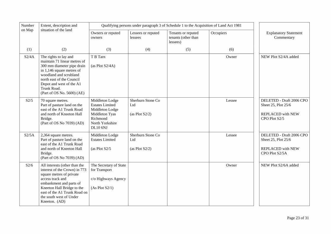
S2/4A The rights to lay and maintain 71 linear metres of 300 mm diameter pipe drain in 1,146 square metres of woodland and scrubland north east of the Council Depot and west of the A1 Trunk Road. (Part of OS No. 5600) (AE)
T B Tarn (as Plot S2/4A)
Owner NEW Plot S2/4A added
S2/5 70 square metres. Part of pasture land on the east of the A1 Trunk Road and north of Kneeton Hall Bridge. (Part of OS No 7039) (AD)
Middleton Lodge Estates Limited Middleton Lodge Middleton Tyas Richmond North Yorkshire DL10 6NJ
Sherburn Stone Co Ltd (as Plot S2/2)
Lessee DELETED - Draft 2006 CPO Sheet 25, Plot 25/6 REPLACED with NEW CPO Plot S2/5
S2/5A 2,364 square metres. Part of pasture land on the east of the A1 Trunk Road and north of Kneeton Hall Bridge. (Part of OS No 7039) (AD)
Middleton Lodge Estates Limited (as Plot S2/5
Sherburn Stone Co Ltd (as Plot S2/2)
Lessee DELETED - Draft 2006 CPO Sheet 25, Plot 25/6 REPLACED with NEW CPO Plot S2/5A
S2/6 All interests (other than the interest of the Crown) in 773 square metres of private access track and embankment and parts of Kneeton Hall Bridge to the east of the A1 Trunk Road on the south west of Under Kneeton. (AD)
The Secretary of State for Transport c/o Highways Agency (As Plot S2/1)
Owner NEW Plot S2/6A added

Page 24 of 31
Number on Map
Extent, description and situation of the land
Qualifying persons under paragraph 3 of Schedule 1 to the Acquisition of Land Act 1981
Owners or reputed owners
Lessees or reputed lessees
Tenants or reputed tenants (other than lessees)
Occupiers Explanatory Statement Commentary
(1) (2) (3) (4) (5) (6)
S2/6A All interests (other than the interest of the Crown) in 69 square metres of Kneeton Lane (C46) to the east of the A1 Trunk Road on the south west of Under Kneeton. (AD)
The Secretary of State for Transport c/o Highways Agency (As Plot S2/1)
North Yorkshire County Council County Hall Northallerton North Yorkshire DL7 8AD (as Highways Authority)
NEW Plot S2/6B added
S2/6B All interests (other than the interest of the Crown) in 3,210 square metres of Kneeton Lane (C46) to the east of the A1 Trunk Road on the south west of Under Kneeton. (AD)
The Secretary of State for Transport c/o Highways Agency (As Plot S2/1)
North Yorkshire County Council (as Highways Authority) (As Plot S2/6A)
NEW Plot S2/6B added
In the Parishes of Middleton Tyas and Barton in the District of Richmondshire
S2/6C All interests (other than the interest of the Crown) in 3,896 square metres of Kneeton Lane (C46) to the east of the A1 Trunk Road on the south west of Under Kneeton. (AD)
The Secretary of State for Transport c/o Highways Agency (As Plot S2/1)
North Yorkshire County Council (as Highways Authority) (As Plot S2/6A)
NEW Plot S2/6C added
S2/6D All interests (other than the interest of the Crown) in 3,848 square metres of Kneeton Lane (C46) to the east of the A1 Trunk Road on the south west of Under Kneeton. (AD)
The Secretary of State for Transport c/o Highways Agency (As Plot S2/1)
North Yorkshire County Council (as Highways Authority) (As Plot S2/6A)
NEW Plot S2/6D added
Page 25 of 31
Number on Map
Extent, description and situation of the land
Qualifying persons under paragraph 3 of Schedule 1 to the Acquisition of Land Act 1981
Owners or reputed owners
Lessees or reputed lessees
Tenants or reputed tenants (other than lessees)
Occupiers Explanatory Statement Commentary
(1) (2) (3) (4) (5) (6)
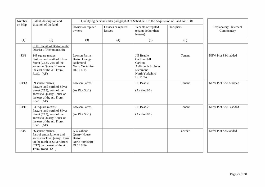
In the Parish of Barton in the District of Richmondshire
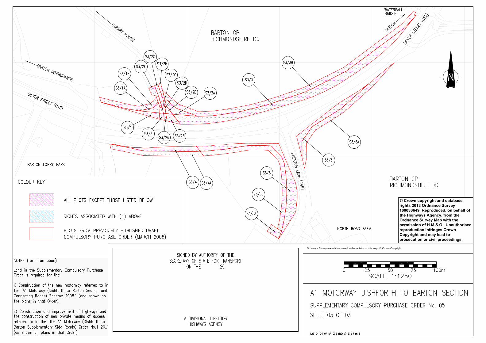
S3/1 143 square metres. Pasture land north of Silver Street (C12), west of the access to Quarry House on the east of the A1 Trunk Road. (AF)
Lawson Farms Barton Grange Richmond North Yorkshire DL10 6HS
J E Beadle Carlton Hall Carlton Aldbrough St. John Richmond North Yorkshire DL11 7AJ
Tenant NEW Plot S3/1 added
S3/1A 99 square metres. Pasture land north of Silver Street (C12), west of the access to Quarry House on the east of the A1 Trunk Road. (AF)
Lawson Farms (As Plot S3/1)
J E Beadle (As Plot 3/1)
Tenant NEW Plot S3/1A added
S3/1B 330 square metres. Pasture land north of Silver Street (C12), west of the access to Quarry House on the east of the A1 Trunk Road. (AF)
Lawson Farms (As Plot S3/1)
J E Beadle (As Plot 3/1)
Tenant NEW Plot S3/1B added
S3/2 36 square metres. Part of embankments and access track to Quarry House on the north of Silver Street (C12) on the east of the A1 Trunk Road. (AF)
K G Gibbon Quarry House Barton North Yorkshire DL10 6NA
Owner NEW Plot S3/2 added
Page 26 of 31
Number on Map
Extent, description and situation of the land
Qualifying persons under paragraph 3 of Schedule 1 to the Acquisition of Land Act 1981
Owners or reputed owners
Lessees or reputed lessees
Tenants or reputed tenants (other than lessees)
Occupiers Explanatory Statement Commentary
(1) (2) (3) (4) (5) (6)
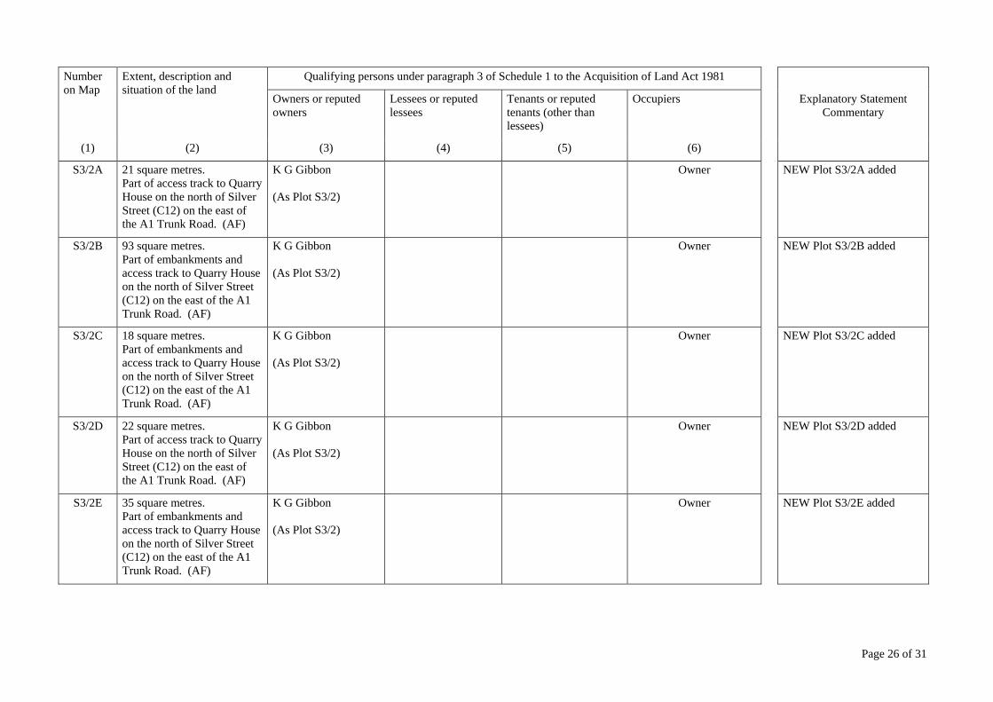
S3/2A 21 square metres. Part of access track to Quarry House on the north of Silver Street (C12) on the east of the A1 Trunk Road. (AF)
K G Gibbon (As Plot S3/2)
Owner NEW Plot S3/2A added
S3/2B 93 square metres. Part of embankments and access track to Quarry House on the north of Silver Street (C12) on the east of the A1 Trunk Road. (AF)
K G Gibbon (As Plot S3/2)
Owner NEW Plot S3/2B added
S3/2C 18 square metres. Part of embankments and access track to Quarry House on the north of Silver Street (C12) on the east of the A1 Trunk Road. (AF)
K G Gibbon (As Plot S3/2)
Owner NEW Plot S3/2C added
S3/2D 22 square metres. Part of access track to Quarry House on the north of Silver Street (C12) on the east of the A1 Trunk Road. (AF)
K G Gibbon (As Plot S3/2)
Owner NEW Plot S3/2D added
S3/2E 35 square metres. Part of embankments and access track to Quarry House on the north of Silver Street (C12) on the east of the A1 Trunk Road. (AF)
K G Gibbon (As Plot S3/2)
Owner NEW Plot S3/2E added

Page 27 of 31
Number on Map
Extent, description and situation of the land
Qualifying persons under paragraph 3 of Schedule 1 to the Acquisition of Land Act 1981
Owners or reputed owners
Lessees or reputed lessees
Tenants or reputed tenants (other than lessees)
Occupiers Explanatory Statement Commentary
(1) (2) (3) (4) (5) (6)
S3/2F 98 square metres. Part of embankments, verge and access track to Quarry House on the north of Silver Street (C12) on the east of the A1 Trunk Road. (AF)
K G Gibbon (As Plot S3/2)
Owner NEW Plot S3/2F added
S3/2G 95 square metres. Part of access track to Quarry House on the north of Silver Street (C12) on the east of the A1 Trunk Road. (AF)
K G Gibbon (As Plot S3/2)
Owner NEW Plot S3/2G added
S3/2H 57 square metres. Part of embankments, verge and access track to Quarry House on the north of Silver Street (C12) on the east of the A1 Trunk Road. (AF)
K G Gibbon (As Plot S3/2)
Owner NEW Plot S3/2H added
S3/3 2,010 square metres. Part of arable land north of Silver Street (C12), east of the access to Quarry House, southwest of Waterfall Bridge on the east of the A1 Trunk Road. (AF)
E M Hall Hadleigh House 8 Church Meadows Barton Richmond North Yorkshire DL10 6NQ
Owner NEW Plot S3/3 added
S3/3A 174 square metres. Part of arable land north of Silver Street (C12) and east of the access to Quarry House on the east of the A1 Trunk Road. (AF)
E M Hall (As Plot S3/3)
Owner NEW Plot S3/3A added
Page 28 of 31
Number on Map
Extent, description and situation of the land
Qualifying persons under paragraph 3 of Schedule 1 to the Acquisition of Land Act 1981
Owners or reputed owners
Lessees or reputed lessees
Tenants or reputed tenants (other than lessees)
Occupiers Explanatory Statement Commentary
(1) (2) (3) (4) (5) (6)
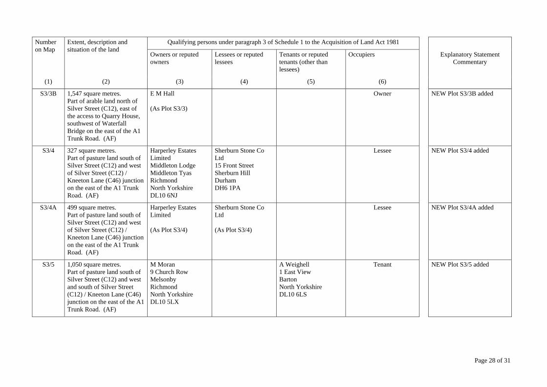
S3/3B 1,547 square metres. Part of arable land north of Silver Street (C12), east of the access to Quarry House, southwest of Waterfall Bridge on the east of the A1 Trunk Road. (AF)
E M Hall (As Plot S3/3)
Owner NEW Plot S3/3B added
S3/4 327 square metres. Part of pasture land south of Silver Street (C12) and west of Silver Street (C12) / Kneeton Lane (C46) junction on the east of the A1 Trunk Road. (AF)
Harperley Estates Limited Middleton Lodge Middleton Tyas Richmond North Yorkshire DL10 6NJ
Sherburn Stone Co Ltd 15 Front Street Sherburn Hill Durham DH6 1PA
Lessee NEW Plot S3/4 added
S3/4A 499 square metres. Part of pasture land south of Silver Street (C12) and west of Silver Street (C12) / Kneeton Lane (C46) junction on the east of the A1 Trunk Road. (AF)
Harperley Estates Limited (As Plot S3/4)
Sherburn Stone Co Ltd (As Plot S3/4)
Lessee NEW Plot S3/4A added
S3/5 1,050 square metres. Part of pasture land south of Silver Street (C12) and west and south of Silver Street (C12) / Kneeton Lane (C46) junction on the east of the A1 Trunk Road. (AF)
M Moran 9 Church Row Melsonby Richmond North Yorkshire DL10 5LX
A Weighell 1 East View Barton North Yorkshire DL10 6LS
Tenant NEW Plot S3/5 added

Page 29 of 31
Number on Map
Extent, description and situation of the land
Qualifying persons under paragraph 3 of Schedule 1 to the Acquisition of Land Act 1981
Owners or reputed owners
Lessees or reputed lessees
Tenants or reputed tenants (other than lessees)
Occupiers Explanatory Statement Commentary
(1) (2) (3) (4) (5) (6)
S3/5A 120 square metres. Part of pasture land south of Silver Street (C12) and west of Kneeton Lane (C46) and North Road Farm on the east of the A1 Trunk Road. (AF)
M Moran (As Plot S3/5)
A Weighell (As Plot S3/5)
Tenant NEW Plot S3/5A added
S3/5B 839 square metres. Part of pasture land south of Silver Street (C12) and west and south of Silver Street (C12) / Kneeton Lane (C46) junction on the east of the A1 Trunk Road. (AF)
M Moran (As Plot S3/5)
A Weighell (As Plot S3/5)
Tenant NEW Plot S3/5B added
S3/6 424 square metres. Part of arable land south of Silver Street (C12), east of Kneeton Lane (C46) and north of North Road Farm on the east of the A1 Trunk Road. (AF)
Lawson Farms (As Plot S3/1)
J E Beadle (As Plot 3/1)
Tenant NEW Plot S3/6 added
S3/6A 681 square metres. Part of arable land south of Silver Street (C12), east of Kneeton Lane (C46) and north of North Road Farm on the east of the A1 Trunk Road. (AF)
Lawson Farms (As Plot S3/1)
J E Beadle (As Plot 3/1)
Tenant NEW Plot S3/6A added
Page 30 of 31
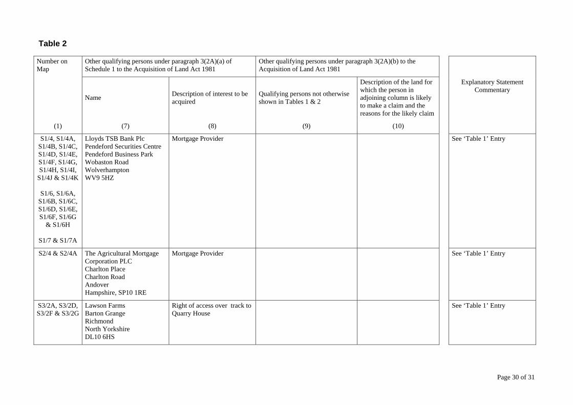
Table 2
Number on Map
Other qualifying persons under paragraph 3(2A)(a) of Schedule 1 to the Acquisition of Land Act 1981
Other qualifying persons under paragraph 3(2A)(b) to the Acquisition of Land Act 1981
Name Description of interest to be acquired
Qualifying persons not otherwise shown in Tables 1 & 2
Description of the land for which the person in adjoining column is likely to make a claim and the reasons for the likely claim
Explanatory Statement Commentary
(1) (7) (8) (9) (10)
S1/4, S1/4A, S1/4B, S1/4C, S1/4D, S1/4E, S1/4F, S1/4G, S1/4H, S1/4I,
S1/4J & S1/4K
S1/6, S1/6A, S1/6B, S1/6C, S1/6D, S1/6E, S1/6F, S1/6G
& S1/6H
S1/7 & S1/7A
Lloyds TSB Bank Plc Pendeford Securities Centre Pendeford Business Park Wobaston Road Wolverhampton WV9 5HZ
Mortgage Provider See ‘Table 1’ Entry
S2/4 & S2/4A The Agricultural Mortgage Corporation PLC Charlton Place Charlton Road Andover Hampshire, SP10 1RE
Mortgage Provider See ‘Table 1’ Entry
S3/2A, S3/2D, S3/2F & S3/2G
Lawson Farms Barton Grange Richmond North Yorkshire DL10 6HS
Right of access over track to Quarry House
See ‘Table 1’ Entry
Page 31 of 31
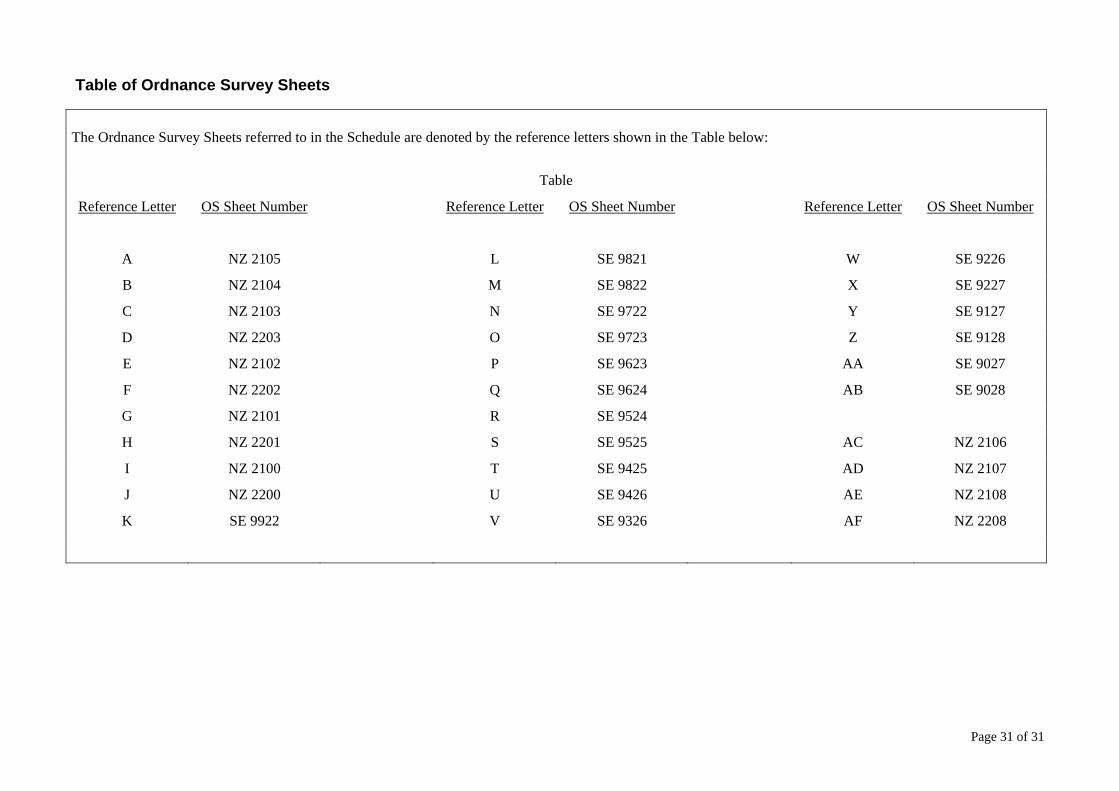
Table of Ordnance Survey Sheets
The Ordnance Survey Sheets referred to in the Schedule are denoted by the reference letters shown in the Table below:
Table
Reference Letter OS Sheet Number Reference Letter OS Sheet Number Reference Letter OS Sheet Number
A NZ 2105 L SE 9821 W SE 9226
B NZ 2104 M SE 9822 X SE 9227
C NZ 2103 N SE 9722 Y SE 9127
D NZ 2203 O SE 9723 Z SE 9128
E NZ 2102 P SE 9623 AA SE 9027
F NZ 2202 Q SE 9624 AB SE 9028
G NZ 2101 R SE 9524
H NZ 2201 S SE 9525 AC NZ 2106
I NZ 2100 T SE 9425 AD NZ 2107
J NZ 2200 U SE 9426 AE NZ 2108
K SE 9922 V SE 9326 AF NZ 2208
© Crown copyright and database
rights 2013 Ordnance Survey
100030649. Reproduced, on behalf of
the Highways Agency, from the
Ordnance Survey Map with the
permission of H.M.S.O. Unauthorised
reproduction infringes Crown
Copyright and may lead to
prosecution or civil proceedings.
© Crown copyright and database
rights 2013 Ordnance Survey
100030649. Reproduced, on behalf of
the Highways Agency, from the
Ordnance Survey Map with the
permission of H.M.S.O. Unauthorised
reproduction infringes Crown
Copyright and may lead to
prosecution or civil proceedings.
Ordnance Survey material was used in the revision of this map Crown Copyright
A1A1
A1A1
© Crown copyright and database
rights 2013 Ordnance Survey
100030649. Reproduced, on behalf of
the Highways Agency, from the
Ordnance Survey Map with the
permission of H.M.S.O. Unauthorised
reproduction infringes Crown
Copyright and may lead to
prosecution or civil proceedings.
Ordnance Survey material was used in the revision of this map Crown Copyright
A1 A1A1
A1
© Crown copyright and database
rights 2013 Ordnance Survey
100030649. Reproduced, on behalf of
the Highways Agency, from the
Ordnance Survey Map with the
permission of H.M.S.O. Unauthorised
reproduction infringes Crown
Copyright and may lead to
prosecution or civil proceedings.
Ordnance Survey material was used in the revision of this map Crown Copyright

© Crown copyright 2013.You may re-use this information (not including logos) free of charge in any format ormedium, under the terms of the Open Government Licence. To view this licence:visit www.nationalarchives.gov.uk/doc/open-government-licence/
write to the Information Policy Team, The National Archives, Kew, London TW9 4DU,or email [email protected].
This document is also available on our website at www.highways.gov.uk
If you have any enquiries about this publication [email protected] or call 0300 123 5000.Please quote the Highways Agency publications code PR61/13
Highways Agency Media Services MCR N130242
Printed on paper from well-managed forests and other controlled sources.
If you need help using this or any other Highways Agency
information, please call 0300 123 5000 and we will assist you.