disaster prevention
DESCRIPTION
topic for public adminstration studentsTRANSCRIPT
UNIT 5 DISASTER PREVENTION
Structure 5.0 Learning Outcome
5.1 Introduction
5.2 Significance of Disaster Prevention
5.3 Issues involved in Disaster Prevention
5.4 Hazard Mapping for Disaster Prevention
5.5 Planning for Disaster Prevention
5.6 Prevention Guidelines in case of Selected Hazards
5.7 Challenges for South Asia
5.8 Implications for Humanitarian & Development Agencies
5.9 Conclusion
5.10 Key Concepts
5.11 References and Further Reading
5.12 Activities
5.0 LEARNING OUTCOME
After studying this Unit, you should be able to:
• Understand the basic concepts related to Disaster Prevention;
• Learn preventive measures required at each level to minimise the loss of life and damage during an emergency; and
• Examine the implications for Humanitarian and Development Agencies.
5.1 INTRODUCTION The United Nations International Strategy for Disaster Reduction (ISDR) defines disaster prevention as “activities to provide outright avoidance of the adverse impacts of hazards and means to minimise related environmental, technological, and biological disasters. Depending on social and technical feasibility and cost/benefit considerations, investing in preventive measures is justified, particularly in areas frequently affected by disasters. In the context of public awareness and education, related to disaster risk reduction, changing attitudes and behaviour contribute to creating a “culture of prevention.”
Preparedness includes measures taken to ensure readiness of the administrative apparatus to respond quickly and efficiently to a disaster in order to minimise the loss to life and property. Disaster preparedness and prevention require policy and resources for the purpose. Pertinent questions to be asked in this regard include:
1
What is disaster prevention? What does it mean to us and should we invest effort in its application? If the answer is “yes”, then what needs to be done, and how is it to be translated into policy and action? In order to address these questions, the government would need to allocate resources for disaster management, which would envelop the aforesaid concerns.
5.2 SIGNIFICANCE OF DISASTER PREVENTION The continued effects of disasters (man-made and natural) are all too evident to be overlooked. Recent events alone include the devastating effects of Hurricane Katrina in America, Tsunami destruction in South Asia and the recent Earthquake in Pakistan and India, as well as the so-called complex political emergencies (CPE) in Iraq, Afghanistan and Sudan. Such incidences command large- scale emergency response, the arena in which humanitarian agencies have the highest profile. Such events also raise retrospective questions, such as, whether anything could have been done to prevent or reduce the scale of such disasters. In the case of CPE, prevention requires the political will of all those directly involved and able to influence the course of events. For natural disasters, efforts can be directed at reducing the scale of lives lost and property destroyed.
In the last two decades, reducing risk through the implementation of disaster preparedness and prevention measures has been gaining ground. The UN named the decade of the 90’s as the “International Decade for Natural Disaster Reduction (IDNDR).” Whilst the success of the IDNDR is believed by many to have been muted through lack of interest and limited funds, organisations including the European Union, World Bank, DFID, UN and USAID (OFDA) are all investing resources in disaster prevention. Regarding International NGOs; IFRC leads, assigning disaster preparedness delegates to several country teams. Several NGO networks also exist, including the La Red in Latin America, ADRRN in Asia and a new network funded by DFID in sub-saharan Africa. In addition, local NGOs and specialist centers such as SEEDS and ADRC are known for implementing DPP (Disaster Prevention Planning) training and research.
The message inherent in these initiatives is the growing acceptance and action towards the same by many key players in the international aid business that more can and must be done to prevent and/or mitigate the impact of disasters to reduce the risks to vulnerable communities.
To foster a common understanding of the concept of DPP, it is worth looking briefly at what disaster mitigation and preparedness are. A disaster happens when a “hazard” (earthquake, flood, drought, fighting, etc) coincides with a “vulnerable” situation (cities or villages in earthquake/flood prone zones, impoverished people, etc). This is often written as:
Disaster = Hazard + Vulnerability.
Without the coincidence of both these conditions, a disaster would not occur (a hurricane at sea affects nobody, volcanic activity in Hawaii is a tourist spectacle). What this means therefore, is that development actions need to be targeted at reducing vulnerabilities, which are social, physical and economic in nature, incident amongst the most vulnerable, which are the poorest communities in society.
Disaster prevention is analogous to preventive health care. Whilst most efforts are directed towards post -disaster relief, reconstruction and rehabilitation (where the need is all too visible), prevention is often the ignored stage of the cycle of
2

disaster (the ‘invisible’ side to disaster). There is often little interest or political will to take measures for preparation for a disaster that hasn’t happened yet. Yet of course failures to address this can result in enormous losses of life and livelihoods.
5.3 ISSUES INVOLVED IN DISASTER PREVENTION Disaster Prevention therefore implies the protective and preventive actions taken prior to a disaster, directed towards the reduction of risk and the effects of the hazard, that is, the actions that impede the occurrence of a disaster event and prevent and reduce the harmful effects of the event on communities and key installations. Constructing a dam or a levee (embankment) to control floods is an example of a preventive measure. Preventive Measures may include:
Structural Measures: Engineering or Technical Inputs
Non- Structural Measures: Administrative and Managerial Inputs
According to Udono (2002), five types of information are necessary for any/both of the above-mentioned categories of disaster prevention:
What: What occurs, what kind of phenomenon occurs? For example, a heavy rain causes a flood, a landslide or a debris flow. A volcanic eruption ejects a pyroclastic flow.
Where: Where does such a phenomenon appear? How extensive is the range of damage?
How: How large is the scale of phenomenon? How intense is it? For example, there is a heavy rain of 500mm in one day, or lava flow of 3000 m.
How does the phenomenon develop or spread? How does it come up? For example, there is a scenario of volcanic eruption such as Earthquake → Ash → Pyroclastic flow → Lava flow.
When: When does a phenomenon occur or when is it likely to occur? What is the frequency or probability of occurrence? For example, there is a heavy rain that occurs once in 30 years, or a great volcanic eruption that occurs once in 200 years.
Who: Who suffers from a disaster? How high is the grade of disaster? How many deaths, building damage or collapse? How much is the total loss?
5.4 HAZARD MAPPING FOR DISASTER PREVENTION Hazard mapping is explained as “the process of establishing geographically, where and to what extent, particular phenomena are likely to pose a threat to people, property, infrastructure, and economic activities. Hazard mapping represents the result of hazard assessment on a map, showing the frequency or probability of occurrences of various magnitudes or occurrences”(DMTP, 1994).
3
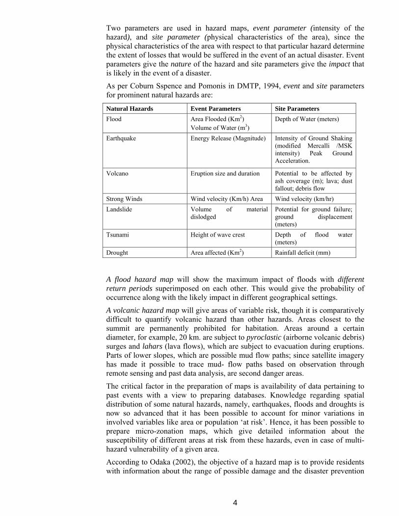
Two parameters are used in hazard maps, event parameter (intensity of the hazard), and site parameter (physical characteristics of the area), since the physical characteristics of the area with respect to that particular hazard determine the extent of losses that would be suffered in the event of an actual disaster. Event parameters give the nature of the hazard and site parameters give the impact that is likely in the event of a disaster.
As per Coburn Sspence and Pomonis in DMTP, 1994, event and site parameters for prominent natural hazards are:
Natural Hazards Event Parameters Site Parameters Flood Area Flooded (Km2)
Volume of Water (m3) Depth of Water (meters)
Earthquake Energy Release (Magnitude) Intensity of Ground Shaking (modified Mercalli /MSK intensity) Peak Ground Acceleration.
Volcano Eruption size and duration Potential to be affected by ash coverage (m); lava; dust fallout; debris flow
Strong Winds Wind velocity (Km/h) Area Wind velocity (km/hr) Landslide Volume of material
dislodged Potential for ground failure; ground displacement (meters)
Tsunami Height of wave crest Depth of flood water (meters)
Drought Area affected (Km2) Rainfall deficit (mm)
A flood hazard map will show the maximum impact of floods with different return periods superimposed on each other. This would give the probability of occurrence along with the likely impact in different geographical settings.
A volcanic hazard map will give areas of variable risk, though it is comparatively difficult to quantify volcanic hazard than other hazards. Areas closest to the summit are permanently prohibited for habitation. Areas around a certain diameter, for example, 20 km. are subject to pyroclastic (airborne volcanic debris) surges and lahars (lava flows), which are subject to evacuation during eruptions. Parts of lower slopes, which are possible mud flow paths; since satellite imagery has made it possible to trace mud- flow paths based on observation through remote sensing and past data analysis, are second danger areas.
The critical factor in the preparation of maps is availability of data pertaining to past events with a view to preparing databases. Knowledge regarding spatial distribution of some natural hazards, namely, earthquakes, floods and droughts is now so advanced that it has been possible to account for minor variations in involved variables like area or population ‘at risk’. Hence, it has been possible to prepare micro-zonation maps, which give detailed information about the susceptibility of different areas at risk from these hazards, even in case of multi-hazard vulnerability of a given area.
According to Odaka (2002), the objective of a hazard map is to provide residents with information about the range of possible damage and the disaster prevention
4
activities. It is important to provide residents with understandable, clear information. There are two types of hazard maps:
Resident Education type: This type of map has the main objective to inform the residents living within the damage forecast area of the risk of danger. The information on areas of danger or places of safety and the basic knowledge on disaster prevention are given to residents. Therefore, it is important that such information is presented in an understandable form.
Administrative Information type: This type of map is used to provide residents with information about the basic materials that the administrative agencies utilise to provide disaster prevention services. These hazard maps can be used to establish a warning system and the evacuation system as well as evidence for land use regulations. They may be used in preventive works also.
There are certain constraints however in hazard mapping. One is security. Detailed mapping with regard to information on transportation routes etc. are not considered feasible from the security point of view. Second, following information regarding vulnerability, there would be more pressure incident on administrative authorities regarding preventive measures.
Post-Yokohama, India is committed to policy towards disaster prevention. The Ministry of Urban Development and Poverty Alleviation, Government of India (1994) constituted an Expert Group to study the following issues related to impact of natural hazards particularly with respect to housing and infrastructure:
• Need to identify vulnerable areas with reference to natural hazards such as earthquakes, cyclones, floods, etc., having a potential of damaging housing stock and related infrastructure.
• Preparation of a Vulnerability Atlas showing areas vulnerable to natural disasters and determination of risk levels of houses.
• Formulation of a strategy for setting up Techno-legal regimes for enforcing disaster resistant construction and planning practices in natural hazard prone human settlements.
Accordingly, a National Policy was chalked out declaring the following objectives:
• Creating Public Awareness about safety from Disasters
• Amending/Enacting legislation for safety from Hazards
• Planning development areas with safety from Hazards
• Protection of habitations from adverse hazard impacts
• Constructing new buildings safe from Hazards
• Retrofitting existing buildings for improving hazard resistance
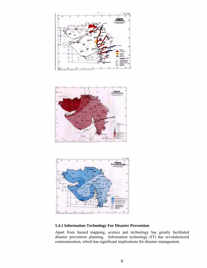
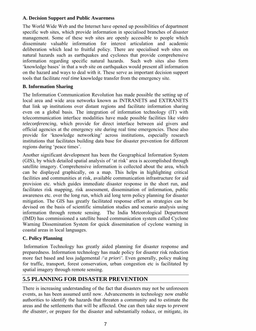
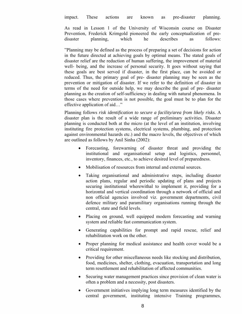
Apart from a multi- hazard vulnerability map, detailed hazard maps for flood, cyclone and wind hazards have been prepared. State wise hazard maps have been prepared, which vividly describe the particular states’ vulnerability to a hazard. For purpose of illustration, the following maps drawn from the Vulnerability Atlas (BMTPC, 1994) give the vulnerability of the state of Gujarat, to floods, earthquakes and cyclone hazards in that order.
5
5.4.1 Information Technology For Disaster Prevention Apart from hazard mapping, science and technology has greatly facilitated disaster prevention planning. Information technology (IT) has revolutionized communication, which has significant implications for disaster management.
6
A. Decision Support and Public Awareness
The World Wide Web and the Internet have opened up possibilities of department specific web sites, which provide information in specialised branches of disaster management. Some of these web sites are openly accessible to people which disseminate valuable information for interest articulation and academic deliberation which lead to fruitful policy. There are specialised web sites on natural hazards such as earthquakes and cyclones that provide comprehensive information regarding specific natural hazards. Such web sites also form ‘knowledge bases’ in that a web site on earthquakes would present all information on the hazard and ways to deal with it. These serve as important decision support tools that facilitate real time knowledge transfer from the emergency site.
B. Information Sharing The Information Communication Revolution has made possible the setting up of local area and wide area networks known as INTRANETS and EXTRANETS that link up institutions over distant regions and facilitate information sharing even on a global basis. The integration of information technology (IT) with telecommunication interface modalities have made possible facilities like video teleconferencing, which provide for direct interface between aid givers and official agencies at the emergency site during real time emergencies. These also provide for ‘knowledge networking’ across institutions, especially research institutions that facilitates building data base for disaster prevention for different regions during ‘peace times’.
Another significant development has been the Geographical Information System (GIS), by which detailed spatial analysis of ‘at risk’ area is accomplished through satellite imagery. Comprehensive information is collected about the area, which can be displayed graphically, on a map. This helps in highlighting critical facilities and communities at risk, available communication infrastructure for aid provision etc. which guides immediate disaster response in the short run, and facilitates risk mapping, risk assessment, dissemination of information, public awareness etc. over the long run, which aid long term policy planning for disaster mitigation. The GIS has greatly facilitated response effort as strategies can be devised on the basis of scientific simulation studies and scenario analysis using information through remote sensing. The India Meteorological Department (IMD) has commissioned a satellite based communication system called Cyclone Warning Dissemination System for quick dissemination of cyclone warning in coastal areas in local languages.
C. Policy Planning Information Technology has greatly aided planning for disaster response and preparedness. Information technology has made policy for disaster risk reduction more fact based and less judgemental /‘a priori’. Even generally, policy making for traffic, transport, forest conservation, urban congestion etc is facilitated by spatial imagery through remote sensing.
5.5 PLANNING FOR DISASTER PREVENTION There is increasing understanding of the fact that disasters may not be unforeseen events, as has been assumed until now. Advancements in technology now enable authorities to identify the hazards that threaten a community and to estimate the areas and the settlements that will be affected. One can then take steps to prevent the disaster, or prepare for the disaster and substantially reduce, or mitigate, its
7
impact. These actions are known as pre-disaster planning. As read in Lesson 1 of the University of Wisconsin course on Disaster Prevention, Frederick Krimgold pioneered the early conceptualization of pre- disaster planning, which he describes as follows: ”Planning may be defined as the process of preparing a set of decisions for action in the future directed at achieving goals by optimal means. The stated goals of disaster relief are the reduction of human suffering, the improvement of material well- being, and the increase of personal security. It goes without saying that these goals are best served if disaster, in the first place, can be avoided or reduced. Thus, the primary goal of pre- disaster planning may be seen as the prevention or mitigation of disaster. If we refer to the definition of disaster in terms of the need for outside help, we may describe the goal of pre- disaster planning as the creation of self-sufficiency in dealing with natural phenomena. In those cases where prevention is not possible, the goal must be to plan for the effective application of aid…”
Planning follows risk identification to secure a facility/area from likely risks. A disaster plan is the result of a wide range of preliminary activities. Disaster planning is conducted both at the micro (at the level of an institution, involving instituting fire protection systems, electrical systems, plumbing, and protection against environmental hazards etc.) and the macro levels, the objectives of which are outlined as follows by Anil Sinha (2002):
• Forecasting, forewarning of disaster threat and providing the institutional and organisational setup and logistics, personnel, inventory, finances, etc., to achieve desired level of preparedness.
• Mobilisation of resources from internal and external sources.
• Taking organisational and administrative steps, including disaster action plans, regular and periodic updating of plans and projects securing institutional wherewithal to implement it, providing for a horizontal and vertical coordination through a network of official and non official agencies involved viz. government departments, civil defence military and paramilitary organisations running through the central, state and field levels.
• Placing on ground, well equipped modern forecasting and warning system and reliable fast communication system.
• Generating capabilities for prompt and rapid rescue, relief and rehabilitation work on the other.
• Proper planning for medical assistance and health cover would be a critical requirement.
• Providing for other miscellaneous needs like stocking and distribution, food, medicines, shelter, clothing, evacuation, transportation and long term resettlement and rehabilitation of affected communities.
• Securing water management practices since provision of clean water is often a problem and a necessity, post disasters.
• Government initiatives implying long term measures identified by the central government, instituting intensive Training programmes,
8
building data based on documentation of disasters and lessons to be learnt there from, and, dissemination of information.
• Integration of disaster management with overall development planning.
• Improving public awareness.
• Investment in R&D, use of modern technology, particularly information and remote sensing technologies.
Interventions Needed
• Evolve model integrated district/ institution wide disaster action plans that include all types of disasters, natural and man made, viz. land slides, accidents, earthquakes, etc., and cover all steps, namely preparedness, mitigation, risk mapping, relief and rehabilitation;
• Evolve a model state plan to ensure a degree of uniformity of approaches, actions and systems and their periodic updating, and,
• Training covering local industries and businesses to ensure better implementation through cooperation of the private corporate sector and the voluntary sector.
5.6 PREVENTION GUIDELINES IN CASE OF SELECTED HAZARDS A. Landslides According to R.S. Tolia, Rakesh Sharma, R.K. Pande, and J.K Pathak (2001), apart from natural causes like excessive rainfall, earthquakes, and changes in soil slope composition, in structure, hydrology or vegetation, anthropogenic interferences with the environment are also responsible for causing landslides. For example in Uttarakhand, major landslides occur because of blasting carried out for road cuttings. Other man- made factors are; construction of dams or reservoirs, housing schemes, roads, agricultural practices on steep slopes etc., implemented without proper environmental impact assessments. Deforestation also contributes to soil erosion. Even natural causes are not altogether beyond control, if right impetus is given to research and requisite authority and say granted to specialists. Preventive and remedial measures are studied within the purview of environmental geomorphology. To prevent water-induced land instability, the following measures are recommended (ESCAP IDNDR, 1999) as per the Bangkok Meeting of the ESCAP:
• Preventing or diverting runoff flows around critical sites;
• De-watering sites using drainage systems;
• Planting trees or shrubs which remove sub-surface water by transpiration;
• Planting deep-rooted vegetation to bind sub-soil material;
• Underpinning foundations to stable rock;
• Battering slopes to stable grades;
• Constructing retaining walls along the toes of critical slopes.
9
B. Cyclones
As per IDNDR ESCAP regional meeting (1999), the principal preventive measures employed to mitigate the destructive and injurious effects of tropical cyclones include the introduction of building design and construction standards aimed at improved resistance to the damaging effects of wind and water.
Preventive measures include both structural measures such as channel modifications, flood detention storages and levees or embankments which are designed to reduce the incidence or extent of flooding, and non-structural measures such as flood insurance, flood zoning restrictions, land-use management, economic incentives, public information and community education. To protect low-lying coastal areas, against damage from tidal inundation, principal structural measures involve the construction of embankments strong enough to withstand the anticipated storm surge heights and forces. Non-structural measures employ land-use zoning and controls over occupation in high hazard areas. Building controls are also imposed to restrict building on vulnerable areas. These controls require that flood heights be set at a safe elevation above a given datum.
Apart from warning systems, which are absolutely imperative, there is need for second line unconventional communication infrastructure, since mainline infrastructure is the first casualty in cyclones. Such facility is known as Amateur Radio, which has emerged as one of the most important second line communication systems during disasters. Though the facility as yet is not as commonly applied in India as it is in Japan and other western developed nations, the Andhra Pradesh government has taken considerable initiative in this regard. The National Institute of Amateur Radio (NIAR) has established HAM radio networks along the coastal belt of Andhra Pradesh. Other measures include providing cyclone shelters at regular distances to help save lives, natural coastal shelter belts like mangroves, trees like casuarinas, eucalyptus, tamarind, neem, etc., which act as natural buffers, building concrete houses to withstand strong winds and tidal waves, grains that do not shred easily in the face of strong winds, and securing cooperation of local folks like fishermen providing training and cooperation of community action groups, which is held imminent now for the success of any measure. The Andhra Pradesh government has implemented all these measures successfully. (Naidu, 2001)
C. Droughts As per IDNDR ESCAP (1999), drought management measures can be considered in two categories: large-scale measures and small scale or on-farm measures. Large-scale surface-water conservation measures revolve around the provision of large water storage reservoirs for the regulation of natural stream-flow and the delivery of this water to critical areas, sometimes over considerable distances, through irrigation, stock or domestic water supply systems. Experience with large dam sites has not been particularly happy, especially in tropical countries, where adverse environmental and socio- economic consequences have resulted, such as waterlogging and salinity and large-scale displacement and loss of livelihoods for the poor. The recommendation emanating from the conference in this regard was that, where possible, large water storages should be designed and operated as multi-purpose structures, incorporating where possible and appropriate, irrigation, flood mitigation, power generation and recreational functions. These may not be mutually consistent, so that multi-purpose design requires a compromise solution based on the best overall net benefits to all potential users. Irrigation, stock and
10
domestic water supply delivery and distribution systems should also be consistent with ecological and cultural considerations in that proposed channel or pipeline routes may traverse areas of natural significance, wildlife habitat or historical or cultural value. Large agricultural tracts in the ESCAP region, in Australia, China, India, Pakistan and Thailand have been degraded because of water logging and salinity due to large irrigation projects. Hence, new irrigation areas need to be carefully sited and selected keeping in consideration factors such as soil type, nature of the underlying strata, quality of irrigation water to be used and provision for proper drainage and disposal system. Good drainage takes care of the problem of water logging and salinity. Drainage water may be too high in salinity for safe disposal into a major watercourse, in which case an effective disposal process, such as transpiration from an irrigated salt-tolerant woodland or evaporation from an evaporation basin, could provide an effective solution. Besides, efficient groundwater management is an urgent necessity. Problem of losses through seepage and evaporation can be taken care of by structural measures like proper control valves at vantage points, good pipeline delivery, temporary storage arrangement at the delivery end, recharge arrangements of excess surface water during floods etc. through permeable seepage arrangements.
Drought is a slow onset disaster. It can be controlled through timely action and proper monitoring of the drought prone area through remote sensing. Citing the report of the Central Soil and Water Conservation Research and Training Institute, Dehradun, Alka Dhameja (2001) feels that topsoil erosion and rapid deforestation is shrinking the supply of groundwater, leading to hydrocide or death of rivers. Soil erosion is part of a wider environmental problem of desertification which is explained as a “ a process of environmental degradation that leads to the abandonment of irrigated fields and pasture lands because of salinisation, water-logging or other forms of soil erosion. Dhameja recommends revival of traditional water storage and harvesting systems such as the Kundis (saucer shaped concrete structures used to store rainwater) of Rajasthan and the Virdas (shallow wells dug in low depressions or jheels to collect water) and the system of temple tanks, as was practiced widely in ancient times in South India and even now exists in many places there.
Other recommended measures include, planting drought resistant seed varieties, educating farmers in drought management and powers to the district magistrate (DM) to intervene at the right time to relieve distress of farmers. It is also felt that employment generation schemes should be formulated and run at the state level instead of being dictated and controlled by the Centre, such as the State Employment Guarantee Scheme in Maharashtra, since it would make timely intervention on the part of the District Collector possible. The said scheme has run successfully in Maharashtra.
D. Earthquakes
Though earthquakes cannot yet be predicted, drafting seismic codes, building regulations to ensure adoption of earthquake resistant technology, retrofitting of old structures that do not satisfactorily comply with safety regulations and regulation of informal settlements like ‘jhuggis’ in hazard prone areas are some of the preventive/mitigation measures that can be attempted. Proper town planning and effective enforcement of legislation and codes for mitigation can effectively prevent loss of life from earthquakes. For administrative preparedness for quick response, regular drills of paramilitary forces, simulation studies, data collection across quake-hit regions of the world with a view to diagnosing vulnerability can
11
minimize losses during earthquakes. Manpower planning would be required to create specialist manpower to plan for and implement safe building measures.
E. Floods Structural measures for flood prevention include construction of levees and floodwalls. However, they create problems of drainage and seepage of water and are also susceptible to breaches. Hence, structural safeguards, such as periodic maintenance of levees, proper side slopes to minimise slumping, ample freeboard to reduce overtopping of levees are required for desired protection. Other structural measures are channel modifications to divert excess flow, permeable groynes and revetments, constructed of piling, rock, concrete, fencing materials, vegetation or other materials etc.
It is being realised that structural protection measures have unviable side effects and limited utility. Hence, undesirable side effects of dams and embankments have shifted focus to non-structural mitigation measures to prevent losses from disasters. While dams result in large-scale displacement of populations and environmental degradation of surrounding areas, embankments cause siltation and water logging problems, creating fresh opportunities of floods rather than preventing their occurrence. Floodwaters carry a heavy load of sediments, which rise the riverbed overtime, making it necessary to raise the embankments to contain the waters. Rainwater is also blocked from flowing into rivers naturally because of embankments. Seepage of water underneath creates water logging in adjoining areas (Kulshrestha, 2001). Experts now feel that total flood disaster prevention is almost impossible in case of floods since costs involved are prohibitive and information of all possible consequences difficult since engineering know how is limited. Hence the focus is now on non -structural measures which aim to reduce susceptibilities such as rehabilitation safeguarding public health, better crop planning to derive maximum benefit from fertile flood zones, regulation of construction in flood prone areas as per hazard assessment and feasibility studies, disaster resistant communication infrastructure, proper drainage in urban areas for flood mitigation, provision of flood insurance etc. (Rangachari, 2001).
In case of structural mitigation measures, the emphasis is now on inter-regional cooperation (for areas such as the Ganga –Brahmaputra- Meghna (GBM) Basin covers India, Nepal, Bhutan and Bangladesh which are low income countries and cannot afford disaster losses) in instituting early warning systems, sharing of hydro-meteorological data, especially in downstream areas regarding upstream water levels for better forecast of floods, warning, provision of drainage facilities for easy discharge of excess water from dams and reservoirs, water harvesting for dry seasons, water management through water storage in common river upstream areas, regular monitoring of dams for regulating water storage and periodic release of excess water; and statistical analysis for risk assessment and estimation of the intensity and hazard occurrence probability with respect to common hazard threats. To clarify further, as per Rangachari, the terrain of Nepal and Bhutan, as well as the upper reaches of the GBM basin in India offer excellent sites for possible storage of water. Bangladesh and the plains of India offer no such facilities. Similarly, when the rivers emerge into the terrain/plains from the hills, they spread out, spill and meander. Construction of embankments could create political controversy. From an engineering perspective as well, cooperation would be necessary between neighbouring countries for better dam and embankment facilities and their maintenance.
12
Some Problems
Some problem areas in prevention arise from the traditional outlooks towards natural disasters. There may be longstanding acceptance of hazards by governments and communities. For instance a nation may have lived for centuries with a recurring major flood problem. Therefore, the need for preventive measures is not recognised. Also cost of some of the preventive measures can be very high and thus these initiatives are completely ruled out. In addition there are other national priorities, which are given more attention. Thus Disaster Prevention may not receive importance in National Planning. Problems like political issues and no public pressure on the government to take preventive measures add to the lack of initiative at the national level in this regard.
Towards Prevention
The problem areas in disaster prevention tend to require various forms of counter measures. However, the nature of disaster prevention is such that the measures involved usually need to be implemented from the senior levels of government. The population of a single community or area is unlikely to be able to institute, for example, a, major flood prevention project (though such populations can produce pressure through action groups and other means). The possible approaches towards this therefore have to have these constraints in mind. Some of the approaches may be:
National Policy: There is need for a clear and comprehensive national disaster policy, which addresses the total disaster management spectrum, including consideration of all aspects of prevention. Within this policy there must be willingness on the part of government to institute preventive measures regardless of their popularity or interest articulation in this regard.
Legislation: If necessary, there should be resort to legislation to implement measures for prevention; for example, mandatory building codes.
Assessment and Monitoring: There should be adequate assessment and monitoring of disaster hazards and vulnerability, so that the need for prevention is accurately identified and defined. This should lead to accurate evaluation of all reasonable disaster prevention projects. In this regard, it is especially important that sensible cost benefit comparisons are worked out; to know whether, by instituting preventive measures, the nation and community is going to gain more (bearing in mind project costs), as against the losses which may arise if nothing is done.
In this context, the establishment and maintenance of a permanent disaster prevention section or centre can play a vitally important part because on behalf of the government, the section/centre should keep a constant watch on disaster management. Thus, it is able to identify the need for preventive measures, whenever such need arises. It is then the responsibility of the section/centre to advise the government with regard to needs in the disaster prevention field, and the priorities, which should apply.
Furthermore, there should be insistence by the disaster prevention section/center (on behalf of the government) that an effective post- disaster
13

review is undertaken after all major disaster events. This review must include advice to government on whether, as a result of the particular disaster, further preventive measures are warranted.
Public Awareness and Education: Public Awareness and Education Programmes should ensure, among other things, that disaster-prone communities are kept aware of risks and vulnerabilities, which may apply to them. In this way, communities are likely to support the need for sensible disaster prevention, if this becomes necessary.
International Assistance: The maintenance of a continuous dialogue with international assistance agencies can also be of use. Such a dialogue helps to ensure that any proposals concerning disaster prevention can be evaluated and submitted to appropriate assistance agencies.
5.7 CHALLENGES FOR SOUTH ASIA
For long, the link between disasters and development had been overlooked. The consequence has been a spate of uncontrolled disasters worldwide. Disaster Prevention seeks to stress the significance of inbuilt strategies for disaster risk reduction in everyday planning for development, such as construction technology in hazard prone areas. Sahni and Ariyabandu (2003) outline the challenges in this regard especially for the South Asian Community, which is among the more vulnerable areas because of coupling of odds; physical vulnerability to natural hazards and widespread poverty of the masses and lack of disaster awareness among policy makers. There is a need to gradually integrate disaster risk analysis into development plans. The process should desirably be bottom up by way of infrastructure provision at the grass roots level such as water harvesting structures in drought prone areas, reviving traditional methods of water preservation, merging water shed management with forestry programmes, locally appropriate early warning systems, shelters, etc. with active involvement of local community based organisations coupled with generation of heightened awareness among communities to utilising the same as an active policy measure. The International Strategy for Disaster Reduction (ISDR) programme/ document entails the following stipulates by way of internationally agreed goals and objectives:
Goals
• Increase public awareness of the risks that natural, technological and environmental hazards pose to modern societies.
• Obtain commitment by public authorities to reduce risks to people, their livelihoods, and social and economic infrastructure and environmental resources.
• Engage public participation at all levels of implementation to create disaster resistant communities through increased partnership and expanded risk reduction networks at all levels.
• Reduce the economic and social losses of disasters as measured, for example, by Gross Domestic Product.
Objectives
14
• Stimulate research and application, provide knowledge, convey experience, build capabilities and allocate necessary resources for reducing or preventing severe and recurrent impacts of hazards, for those people who are most vulnerable.
• Increase opportunities for organisations and multi-disciplinary relationships to foster more scientific and technical contributions to the public decision-making process in matters of hazard, risk and disaster prevention.
• Develop a more proactive interface between management of natural resources and risk reduction practices.
• Form a global community dedicated to making risk and disaster prevention a public value.
• Link risk prevention and economic competitiveness issues to enhance opportunities for greater economic partnerships.
• Complete comprehensive risk assessments and integrate them with development plans.
• Develop and apply risk reduction strategies and mitigation measures with supporting arrangements and resources for disaster prevention at all levels of activity.
• Identify and engage designated authorities, professionals drawn from the widest possible range of expertise and community leaders to develop increased partnership activities.
• Establish risk monitoring capabilities, and early warning systems as integrated processes, with particular attention to emerging hazards with global implications such as those related to climate variation and change, at all levels of responsibility.
• Develop sustained programmes of public information and institutionalised educational components pertaining to hazards and their effects, risk management practices and disaster prevention activities for all ages.
• Establish internationally and professionally agreed standards/methodologies for the analysis and expression of the socio-economic impacts of disasters on societies.
• Seek innovative funding mechanisms dedicated to sustained risk and disaster prevention activities.
In this regard, controlling corruption in the implementation of well- meaning schemes is the key factor in controlling vulnerabilities through well-intentioned policy intervention on the part of the government. For instance as brought out by Janki Andharia (2003), in India vulnerability to disasters is high, especially as people, lack basic facilities like safe/clean drinking water, adequate housing/shelter, schools, hospitals, roads et al. Existing vulnerability is exacerbated/turned to active risk by improprieties like illegally tapping electricity, which crates conditions for fire outbreaks, dumping radioactive and other hazardous waste in rivers against regulations, which creates active threat to peoples’ lives and well being, and other such willful omissions and commissions on the part of people with or without connivance of official functionaries which result in malpractices potently threatening life and
15
property over the impacted area/populace. Curbing malpractices would require proactive policy in this regard with active cooperation of the people. Citing Cernea (1992), Janki Andharia (2003) brings out the constraints in articulating the possibility. People centered development and top-down planning are mutually contradictory, in that they offer two opposing paradigms and hence, difficult choices. The paradox is explained by the following three factors or constraints in desired reconciliation between the government centered and people centered approaches as articulated by Andharia:
• The expanding role of the public sector in launching programmes which discourages popular participation since there is no commensurate effort to evolve mechanisms to involve people.
• The growth of international aid, which amplifies government programmes, while “increasing the distance between the progamme’s center and periphery”;
• The recurrent failure in public programmes due to alienation of intended beneficiaries.
The challenge is to institutionalise people centered approaches in the ‘monopolistic environment’ where the government is the sole provider of public services generally, also, specifically for those related to disaster relief /mitigation. There is need for peoples’ involvement in disaster prevention activities, specifically, since people need to be aware of the vulnerabilities and also of what is being/needs to be done to ameliorate the situation with regard to susceptibilities, physical, economic and social to natural or man-made or any other hazard(s). To that end, right to information and social activism on the part of people or ‘organised volunteerism’ with regard to specific issues/concerns. For example, the foundations of buildings need to be elevated as a general rule in flood prone zones, and likewise, as per requirements with regard to other hazards in different areas. There has to be intense articulation in this regard and sufficient pressure/lobbying for concrete policy, which is unfortunately lacking in third world countries where people are found to be largely passive with regard to their rights and there is not enough activism on their behalf on the part of civil society since level of political development is low. Hence, active institutionalisation of social capital inherent in communities on the part of government can empower communities and give them the channel for articulating their grievances. There have been encouraging beginnings however, as, following the Latur Earthquake, the Government of Maharashtra launched the Maharashtra Emergency Earthquake Rehabilitation Programme (MEERP) in which one of the most progressive features was the importance given to community participation (MEERP Information Brochure, 1998).
Participation is desired, as per Cohen and Uphoff (1977) read in Andharia (2003), with regard to/ in:
• Decision-making, since policy has to ideally respond to articulated concerns, which involves, identifying problems, formulating alternatives, planning activities, allocating resources, etc.
16
• Implementation of programmes, carrying out activities with catalytic assistance from the state, managing and operating programmes, partaking of services etc.
• Procuring/Deriving benefits, individually and/or collectively.
• Evaluating the activity and its outcomes with bearing on the above stated preceding activities, viz. planning, implementation and availing benefits.
Hence project planning for rehabilitation and development must have the aforesaid built- in features and the onus for the same lies on the project planners and the politicians since political will to empower passive communities is a major factor/constraint as has been brought out in researches. Onus for the same is on project planners who are sometimes reluctant at delegating responsibility or parting with authority, more pertinently, and on politicians who are diffident for their own reasons about empowering people.
5.8 IMPLICATIONS FOR HUMANITARIAN & DEVELOPMENT AGENCIES
Five key reasons why disaster prevention and preparedness (DPP) is important for humanitarian and development agencies to address are:
1. Disaster risk reduction is one of the biggest neglected development issues. Since it falls between “emergency” and the “development”, it is ignored on both counts and misunderstand in both respects. Yet it serves both purposes, and can provide a powerful force for good governance.
2. Undertaking large development programmes without consideration of disasters is bad practice. In Bangladesh, reportedly, recent floods have destroyed ten years of development. The same holds true of the recent cyclone in Honduras. Smaller everyday disasters, example. fires in markets also contribute to mounting losses.
3. Humanitarian agencies and their donors have invested huge resources in emergency response and reconstruction. Why not invest more in prevention?
4. DPP provides a ‘bridge’ between relief and development. Probably the strongest argument for addressing DPP lies in this. The language of vulnerability and capacity is the same language of disaster as it is of development
5. New tools for existing problems. If the argument against DPP is that it is being done under other names, then the counter argument is that by focusing interventions according to DPP, new solutions may occur. For example, community interventions addressing a hazard, for example, a flood or fire, can provide a perceived neutral threat that all stakeholders mobilise around, which can lead to other development related spin offs.
17
5.9 CONCLUSION Disaster Prevention and Preparedness is an integrated approach, which requires planned commitment on the part of governments. Prevention means measures designed to prevent natural phenomenon from causing or resulting in disaster or other related emergency situations. It concerns the formulation and implementation of long-range policies and programmes to prevent and eliminate the occurrence of disasters. On the basis of vulnerability analysis of all risks, prevention includes legislation and regulatory measures, principally in the fields of physical and urban planning, public works and building. Preparedness on the other hand means actions designed to minimize loss of life and damage to property, and to organize and facilitate timely and effectively rescue, relief and rehabilitation in case of an event. A well-planned, well-implemented and well- coordinated Disaster Prevention and Preparedness Plan can considerably reduce the damage and destruction due to disasters
5.10 KEY CONCEPTS Disaster: Disaster is defined as “a serious disruption of the
functioning of a society causing widespread human, material, or environmental losses which exceed the ability of the affected society to cope using its own resources” (ISDR).
Disaster Prevention: Disaster Prevention is understood as the process of surveying the work place, identifying areas or situations which might cause or contribute to a disaster, and taking action to eliminate or minimize the areas or situations (www.epa.gov/records/tools/toolkits/vital/b.htm).
Groynes: Groynes protrude into the channel and are designed to divert flow away from the bank, whilst at the same time causing an accumulation of sediment along the toe of the bank and on the downstream side of the groyne structure (ESCAP IDNDR, 1999).
Hazard: Hazard is “a phenomenon that poses a threat to people, structures or economic assets and which may cause a disaster. It could be either manmade or naturally occurring in our environment” (ISDR).
Preparedness: The United Nations Disaster Relief Office (UNDRO) uses the following definition for Disaster Preparedness:
“Disaster Preparedness may be described as (a series of) measures designed to organise and facilitate timely and effective rescue, relief and rehabilitation operations in cases of disaster…Measures of Preparedness include, among others, setting up disaster relief machinery,
18
formulation of emergency relief plans, 5 training of specific groups (and vulnerable communities) to undertake rescue and earmarking funds for relief operation” It therefore concerns immediate measures to reduce risk just before, during and after a disaster, and is defined as “measures, which enable governments, organisations, communities and individuals to respond rapidly and effectively to disaster situations.”
Revetments: Revetments, on the other hand, are constructed along or parallel to the bank, where they serve to reduce the velocity of flow along the bank, thus reducing bank erosion and allowing the riverbank to stabilise (ESCAP IDNDR, 1999).
Risk Reduction: Disaster Management Training Programme (DMTP, 1994) defines risk reduction as “long-term measures to reduce the scale and/or the duration of eventual adverse effects of unavoidable or unpreventable disaster hazards on a society which is ‘at- risk’ by reducing the vulnerability of its people, structures, and economic activities to the impact of known disaster hazards. Typical risk reduction measures include improved building standards, flood plain zoning and land use planning, crop diversification and planning windbreaks. The measures are frequently subdivided into structural and “non- structural,” active and passive measures”. Disaster Mitigation, Prevention and Risk Reduction have been used interchangeably, more or less to refer to similar activities.
Vulnerability: Vulnerability is defined as “the extent to which a community, structure, service, or geographic area is likely to be damaged or disrupted by the impact of a particular hazard, on account of its nature, construction and proximity to hazardous terrain or a disaster prone area.” (ISDR).
5.11 REFERENCES AND FURTHER READING Andharia, Janki, 2003, “Disaster Risk Reduction through Development Orientation in Disaster Management: The Significance of Peoples’ Participation in India”, in Pardeep Sahni and Madhavi Malalgoda Ariyabandu (Eds), Disaster Risk Reduction in South Asia, Prentice-Hall of India, New Delhi.
BMTPC, 1994, Disaster Mitigation & Vulnerability Atlas of India: A Paradigm Shift From Post-Disaster Reconstruction & Relief to Pre-Disaster Pro-Active Approach at http://www.bmtpc.org/object.htm
Coburn, Sspence, Pomonis, 1994, “Vulnerability and Risk Assessment”, 2nd edition, Disaster Management Training Programme, UNDP.
19
Damen, M.C.J and C.J. Van Westen, 2002, “Modeling cyclone hazard in Bangladesh", Department of Earth Resources Surveys, International Institute for Geo-Information Science and Earth Observation (ITC), at http://www.itc.nl/ilwis/default.asp
Dhameja, Alka, 2001, “Drought and Floods: A Case for Dying Wisdom”, in Pardeep Sahni, Alka Dhameja and Uma Medury (Eds), Disaster Mitigation: Experiences and Reflections, Prentice Hall of India, New Delhi.
Disaster Management: A Disaster Manager’s Handbook, 1991, Asian Development Bank, Manila.
“Hazard Mapping and Vulnerability Assessment”, at http://unpan1.un.org/intradoc/groups/public/documents/APCITY/UNPAN009857.pdf.
Kulshrestha, S.M., 2001, “Floods, Embankments and Dams,” in Pardeep Sahni, Alka Dhameja, Uma Medury (Eds.), Disaster Mitigation: Experiences and Reflections, Prentice-Hall of India, New Delhi.
Naidu, Raghavulu B., 2001, “Disaster Mitigation Measures for Cyclone Prone Areas of Andhra Pradesh,” in Pardeep Sahni, Alka Dhameja and Uma Medury (Eds.), Disaster Mitigation: Experiences and Reflections, Prentice-Hall of India, New Delhi.
Rangachari, R, 2001, “ Disaster Preparedness and Mitigation in Flood Management: Cooperation and Networking Among Countries”, in Pardeep Sahni, Alka Dhameja and Uma Medury (Eds.), Disaster Mitigation: Experiences and Reflections, Prentice-Hall of India, New Delhi.
Report of the High Powered Committee for Preparation of Disaster Management Plans, 2001, Government of India, New Delhi.
Sahni, Pardeep and Madhavi Malalgoda Ariyabandu (Eds), 2003, “Introduction,” Disaster Risk Reduction in South Asia, Prentice Hall of India, New Delhi.
Sharma, Vinod K. (Programme Director), 1998, Training Workshop on Vulnerability and Preparedness, National Center for Disaster Management, Indian Institute of Public Administration, New Delhi.
Sinha, Anil, 2002, “Disaster Management: Lessons Drawn and Strategies for the Future”, Paper Presented in the Training Programme on Disaster Management at the Department of Public Administration, University of Lucknow.
Tolia, R.S, Rakesh Sharma, R.K. Pande and J.K. Pathak, 2001, “Landslide Problems in the Uttarakhand Region”, Pardeep Sahni, Alka Dhameja, Uma Medury (Eds), Disaster Mitigation: Experiences and Reflections, Prentice-Hall of India, New Delhi.
Udono, Toshiaki, 2002, Regional Workshop on Total Disaster Risk Management ADRC Annual Report No.5, 2002, at http://www.adrc.or.jp/publications/annual/02/02eng/Chapter2-2_E.p
20
“Water Hazards, Resources and Management for Disaster Prevention: A Review of the Asian Conditions”, IDNDR 1991-1999, IDNDR-ESCAP Regional Meeting for Asia: Risk Reduction & Society in the 21st Century Bangkok, 23-26 February 1999.
University of Wisconsin, Disaster Management Centre Course on Natural Hazards: Causes and Effects: Lesson 1: “Introduction to Natural Hazards”, at http://www.dmc.engr.wisc.edu/courses
5.12 ACTIVITIES
1. List and discuss the possible damage that may happen in your city or village due to any natural disaster. Also suggest measures to prevent each of the damage.
2. Discuss how Disaster Prevention and Preparedness can be planned and implemented at local (city / village level), National and International level.
21