developing a vario-scale imgeo using the constrained tgap ... · developing a vario-scale imgeo...
TRANSCRIPT

Developing a vario-scale IMGeo using the constrained tGAP structure
Master Thesis Arjen Hofman, 12-2-2008

Developing a vario-scale IMGeo using the constrained tGAP structure
ii

iii
Table of contents Preface ......................................................................................................................................... v Summary ......................................................................................................................................vi Samenvatting .............................................................................................................................. viii 1. Introduction.................................................................................................................. 1 1.1 Problem definition ....................................................................................................................... 1 1.2 Research objective ...................................................................................................................... 2 1.3 Research issues........................................................................................................................... 2 1.4 Thesis structure .......................................................................................................................... 3
2. Models and projects at Gemeentewerken Rotterdam .................................................. 5 2.1 Current situation at Gemeentewerken Rotterdam ...................................................................... 5 2.1.1 Large Scale Topographic Base Map ................................................................................... 5 2.1.2 Medium scale Topographic Base Map ................................................................................ 6
2.2 Basisregistraties .......................................................................................................................... 6 2.2.1 Nationale Geo Informatie Infrastructuur............................................................................ 6 2.2.2 Basisregistratie Geografie................................................................................................... 9
2.3 The standard NEN3610 ............................................................................................................. 11 2.4 IMGeo and its implementation in Rotterdam ............................................................................ 13 2.4.1 Structure........................................................................................................................... 13 2.4.2 Status of IMGeo ............................................................................................................... 15
2.5 Top10NL and its implementation in Rotterdam ........................................................................ 16 2.5.1 Structure........................................................................................................................... 16 2.5.2 Current situation............................................................................................................... 17
2.6 Differences between IMGeo and Top10NL ............................................................................... 19 2.6.1 Classes and attributes ...................................................................................................... 19 2.6.2 Geometry.......................................................................................................................... 22
2.7 Related projects in The Netherlands......................................................................................... 23 2.7.1 IMTop ............................................................................................................................... 23 2.7.2 DURP Ondergronden ........................................................................................................ 24 2.7.3 GBKN buildings in Top10NL ............................................................................................. 24
2.8 Conclusions ............................................................................................................................... 25 3. Research methodology ............................................................................................... 27 3.1 The constrained tGAP structure ................................................................................................ 27 3.2 Application of the constrained tGAP structure in this research ................................................ 30
4. Description of the Almere testdatasets ...................................................................... 31 4.1 IMGeo dataset of Almere .......................................................................................................... 31 4.2 Top10NL dataset of Almere ...................................................................................................... 37 4.3 Further pre-processing of the test datasets.............................................................................. 39 4.4 Geometrical and semantical differences between the models.................................................. 41 4.5 Conclusions ............................................................................................................................... 44
Developing a vario-scale IMGeo using the constrained tGAP structure
iv
5. Generalisation: design and implementation............................................................... 45 5.1 Software and programming languages..................................................................................... 45 5.1.1 Software programs ........................................................................................................... 45 5.1.2 Programming languages .................................................................................................. 46
5.2 Assigning class weights and creating the compatibility matrix................................................. 47 5.3 Translation of the test data to Oracle tables in FME Workbench ............................................. 48 5.4 The simple overlay method....................................................................................................... 50 5.5 The maximum area method...................................................................................................... 52 5.5.1 Joining the IMGeo objects with Top10NL in ArcGIS ........................................................ 53 5.5.2 Selecting the right region using the maximum area method........................................... 53 5.5.3 Testing the constrained tGAP structure for the maximum area method ......................... 55
5.6 The 35%-split method .............................................................................................................. 57 5.7 The building first method.......................................................................................................... 60 5.8 Comparison of the methods and conclusions ........................................................................... 62
6. Improvements for the constrained tGAP structure .................................................... 67 6.1 Improvements of the weights and compatibilities .................................................................... 67 6.2 tGAP without constraint ............................................................................................................ 73 6.3 Testing the constrained tGAP on a larger dataset .................................................................... 75 6.4 Conclusions ............................................................................................................................... 80
7. Conclusions, recommendations and future research ................................................. 81 7.1 Conclusions ............................................................................................................................... 81 7.2 Recommendations..................................................................................................................... 82 7.3 Future research ......................................................................................................................... 84
References.................................................................................................................................. 85 List of appendices........................................................................................................................ 88 Appendix A: UML class diagram of IMGeo ................................................................................ 89 Appendix B: UML class diagram of Top10NL ............................................................................ 90 Appendix C: Type of geometry of spatial attributes in IMGeo .................................................... 91 Appendix D: Type of geometry of sptial attributes in Top10NL .................................................. 95 Appendix E: Statistics of the test area ....................................................................................109 Appendix F: Python scripts ....................................................................................................111 Appendix G: tGAP code in PL/SQL ..........................................................................................115 Appendix H: Visualised results of the constrained tGAP ............................................................122 Appendix I: Visualisation of the trials to improve the values for weights and compatibilities ......155 Appendix J: Visualisation of the tGAP without constraint .........................................................164 Appendix K: Visualisation of the constrained tGAP methods for the large dataset ......................171

v
Preface The title of this report is ‘Developing a vario-scale IMGeo using the constrained tGAP tree’. This report is the final result of the master thesis of Arjen Hofman. The master thesis is the author’s final work to finalize the study on Geomatics at Delft, University of Technology. The work for this master thesis has been mainly executed at Gemeentewerken Rotterdam, the department of civil works in Rotterdam. The main theme of this report is the generalisation of geographical map data. The report contains theoretical and practical parts. It deepens the current knowledge on differences between the large scale geographical standard IMGeo and the medium scale geographical standard Top10NL. After these theoretical differences the practice that is shown appears to have more difficulties; the test data of Almere shows some unexpected issues. Finally the pre-processed test data is to be generalised using the concepts of the constrained tGAP structure, which will be explained later in this report. A word of thanks to my supervisors and graduation professor: Arta Dilo, the supervisor at Delft, University of Technology; Nicole Borkens, the supervisor at Gemeentewerken Rotterdam; Michiel Boelhouwer and Evert Bontenbal, the practical supervisors at Gemeentewerken Rotterdam and Prof. Peter van Oosterom, professor at the chair of GIS Technology at Delft, University of Technology. Also thanks to Jonathan Damen, student at Utrecht University who did his master thesis at Vicrea at the same time and on the subject of generalisation, for the many discussions we had on the topic and the possibility to test my data with his algorithms. Finally, thanks to my girlfriend Martine for her support during this master thesis. Rotterdam, February 12th 2008 Arjen Hofman

Developing a vario-scale IMGeo using the constrained tGAP structure
vi
Summary The aim of this master thesis has been to answer the question: How can a vario-scale IMGeo be designed and developed by applying the constrained tGAP structure with Top10NL as initial constraint? This research has been done under authority of Gemeentewerken Rotterdam and TU Delft. For Gemeentewerken Rotterdam the main goal is to investigate the possibilities of automatic generalisation based on their project ‘Basisregistratie Geografie’, for TU Delft the main goal is to see the concept of the constrained tGAP structure being investigated. The models IMGeo, a new large scale topographical standard in The Netherlands, and Top10NL, the authentic registration for medium scale topography in The Netherlands, are both derived from NEN 3610; they form the basis for the generalisation in this research. The main differences are explained by their backgrounds. IMGeo originates from the GBKN, whereas Top10NL is based on Top10Vector. The fact that these models are not made cooperatively is bad luck for this research; no object class hierarchy could be made from these models, because there are object classes in Top10NL which don’t even exist in IMGeo. The Top10NL object classes therefore can’t be seen as a generalisation of the object classes of IMGeo. The generalisation approach in this research was the constrained tGAP structure, a concept from the universities of Hannover and Delft. In this research IMGeo objects were assigned to Top10NL regions. Four possible methods to assign IMGeo objects to Top10NL regions were developed:
• Simple overlay method An intersection between the models where every IMGeo object is split at the
borders of the overlapping Top10NL object. In the end result only Top10NL geometry will be visible.
• The maximum area method The Top10NL object which overlaps the IMGeo object the most is the shape to which the whole IMGeo object is assigned to. The IMGeo geometry is kept in this method.
• The 35%-split method If an IMGeo object belongs for more than 35 % to two Top10NL objects we consider this Top10NL geometry as enrichment of the structure; therefore the IMGeo object is split and a new IMGeo object is created. For all IMGeo objects that don’t have two Top10NL objects overlapping for more than 35% the maximum area method is applied
• The building first method This method assigns IMGeo-buildings to a building region in case of some overlap with a Top10NL building without considering the amount of overlap. The other IMGeo objects are selected as in the maximum area method.
The building first method has been developed because the results of the maximum area method and the 35%-split method were unsatisfying. This building first method gives the best results of the four methods. With this method further research was done.

vii
For the test dataset from the municipality of Almere class weights and class compatibilities have been derived, which are input values for the tGAP structure. This has been done after tuning the weights and compatibilities of the constrained tGAP structure and comparing the end result to the Top10NL dataset. Final conclusion of this report is that the constrained tGAP absolutely offers possibilities for automatic generalisation from large to medium scale data. However, the amount of pre-processing of the data and the state of development of the tGAP structure are reasons for a governmental organisation like Gemeentewerken Rotterdam to not yet develop a product like this. A topological structure of the models might possibly solve these problems. Cooperation between researching parties, industrial parties and governmental organisations in projects like DURP Ondergronden could be a good opportunity to develop a vario-scale IMGeo as described in this report.

Developing a vario-scale IMGeo using the constrained tGAP structure
viii
Samenvatting Het doel van dit afstudeeronderzoek was om een antwoord te vinden op de volgende onderzoeksvraag: Hoe kan een IMGeo met een variabele schaal worden ontworpen en ontwikkeld volgens de ‘constrained tGAP’ structuur met Top10NL als voorwaarde? Dit onderzoek is gedaan in opdracht van Gemeentewerken Rotterdam en de TU Delft. Voor Gemeentewerken Rotterdam was het belangrijkste doel om de mogelijkheden van automatische generalisatie te bekijken in het kader van het project ‘Basisregistratie Geografie’, voor de TU Delft was het belangrijkste doel om het concept van de constrained tGAP structuur verder uit te werken. De modellen IMGeo, een nieuwe grootschalige topografische standaard in Nederland, en Top10NL, de Basisregistratie Topografie, zijn beide afgeleid van NEN 3610; deze modellen vormen de basis van dit onderzoek. De belangrijkste verschillen tussen deze modellen kunnen worden verklaard uit hun achtergronden. IMGeo is afgeleid van de GBKN en Top10NL heeft zijn wortels in Top10Vector. Het is jammer voor dit onderzoek dat deze modellen niet parallel zijn gemaakt, om deze reden kon er geen klassenhierarchie gemaakt worden tussen de modellen, omdat er object klassen zijn in Top10NL die niet eens voorkomen in IMGeo. De objectklassen van Top10NL kunnen daarom ook niet worden gezien als een generalisatie van de objectklassen van IMGeo. De generalisatie aanpak in dit onderzoek was de constrained tGAP structuur, een concept van de universiteiten van Hannover en Delft. In dit onderzoek werden IMGeo objecten toegekend aan Top10NL regio’s. Vier mogelijke methoden om dit te doen zijn onderzocht:
• Eenvoudige intersectie methode Dit is een intersectie tussen de modellen waar elk IMGeo object wordt
gesplitst op de rand van een Top10NL object. Dit heeft als gevolg dat het in het eindresultaat enkel nog de Top10NL geometry waar te nemen is.
• De ‘maximum area’ methode Het Top10NL object dat de meeste overlap heeft met het IMGeo object is de Top10NL regio waar het IMGeo object aan wordt toegewezen. In deze methode blijft daarom de geometrie van IMGeo behouden.
• De ‘35%-split’ methode Als een IMGeo object voor meer dan 35 % overlapt met twee Top10NL object, dan beschouwen we de Top10NL gemetrie als een verrijking voor de structuur. Daarom wordt het IMGeo object in dit geval gesplitst en wordt er dus een nieuw IMGeo object gecreëerd. Voor alle IMGeo objecten die niet 2 Top10NL objecten hebben die aan deze voorwaarde voldoen, wordt de ‘maximum area’ methode uitgevoerd.
• De ‘building first’ methode Deze methode kent IMGeo-gebouwen toe aan Top10NL gebouw regio als er sprake is van enige overlap tussen het IMGeo gebouw en de Top10NL regio ongeacht het formaat van het overlappende gebied. De andere IMGeo objecten worden weer geselcteerd volgens de ‘maximum area’ methode.

ix
De ‘building first method’ is ontwikkeld, omdat de resultaten van de andere methodes niet goed genoeg waren. Deze ‘building first method’ geeft de beste resultaten van de vier genoemde methodes. Het verdere onderzoek is dan ook gedaan met deze methode. Voor de dataset van de Gemeente Almere zijn gewichten en overgangsmatrices voor de verschillende objectklassen afgeleid, dit zijn ingangswaarden voor de tGAP structuur. Dit is gedaan door de eindresultaten van de constrained tGAP te itereren en deze te vergelijken met de Top10NL dataset. Conclusie van dit rapport is dat de constrained tGAP absoluut mogelijkheden biedt voor automatische generalisatie van grootschalige naar kleinschalige topografie. De hoeveelheid voorwerk die de data vereist en de onderzoeksstatus van de tGAP structuur zijn echter redenen voor Gemeentewerken Rotterdam om dit nog niet in productie te kunnen gaan nemen. Een topologische structuur voor de topografische modellen zou een hoop datavoorbereiding mogelijk kunnen voorkomen. Samenwerking tussen onderzoekers, bedrijven en overheidspartijen zoals in een project als DURP Ondergronden kan goede mogelijkheden bieden om een IMGeo met variabele schaal, zoals beschreven in dit rapport, te ontwikkelen.


1. Introduction
1
1. Introduction Automatic generalisation of geographical datasets is the issue to be discussed in this master thesis report. If you mention this issue to a layman, he will probably reply saying: “Didn’t that exist before?” Most people nowadays are known to products like Google Earth and Google Maps and they think that all geographical data can be just generalised in the way Google does it. When looking at a more formal definition of generalisation, as stated by the ICA (ICA, 1973), we see that Google actually performs a good way of generalisation. “Generalisation is the selection and simplified representation of detail appropriate to the scale and/or purpose of the map”. Google only wants to display that amount of roads which is appropriate for a certain scale and doesn’t want to display any other information besides the difference between water, cities and other land. Google also uses fixed scales stored in giant databases. This requires lots of storage space and disables vario-scale zooming. When talking about automatic generalisation of topographical maps more classes are involved which all have their importance in a map. If we want to extract topographical maps at all scales from the most detailed map and avoid data redundancy, this requires more advanced generalisation tools. To see whether it is possible to extract the medium scale topographical map from a large scale base map this research has been done within the municipality of Rotterdam.
1.1 Problem definition
The collection of geographical data at different scales seems to be more work than necessary. After all, the real world objects that are represented are still the same. Manufacturing geographical data products at different scales from one single data set should be possible, but why isn’t this as easy as it seems? The question is: what information has to be shown at what scale? In producing small and medium scale topographical maps the municipality of Rotterdam has already answered this question, but the question whether this can be automatised still exists. Within the framework of the project Basisregistratie Geografie, which identifies core registrations on geography within the municipality, the municipality asks itself the question whether the production of geographical data can’t be more efficient. Data collection at different scales in Rotterdam is now done separately, while collecting data only once would be far more efficient. This problem of inefficiency forms the basis of this master thesis. In this thesis it is shown whether it is possible to create a vario-scale geographical dataset using a large scale data set. The dataset that will be primarily used is a 1:1,000 dataset according to IMGeo, a new Dutch model on large scale topography. Through a constrained tGAP structure, which will be introduced in section 3.1, it is shown to what extent it is possible to create a vario-scale IMGeo. The constrained tGAP is an idea that builds on the topological Generalised Area

Developing a vario-scale IMGeo using the constrained tGAP structure
2
Partition (tGAP) structure as developed at the TU Delft. The constraint that will be used in this structure is Top10NL, the Dutch 1:10,000 map standard. The main question of this master thesis is: How can a vario-scale IMGeo be designed and developed by applying the constrained tGAP structure with Top10NL as initial constraint?
1.2 Research objective
Primary goal of this research was to make a vario-scale IMGeo model with constraints from the Top10NL using the tGAP structure which is developed by the TU Delft (Van Oosterom, 2005; Van Oosterom et al., 2006). It is known that IMGeo and Top10NL are both based on NEN3610, but have some different specifications. A related goal was to see whether it is possible to let the models (partially) match. The used method is the constrained tGAP structure. This structure is a concept proposed by Jan Haunert from the University of Hannover during a visit to the Delft University of Technology. The method is enriched with methods for pre-processing data from different sources and with better weight and compatibility estimates.
1.3 Research issues
By studying the organisation of the municipality of Rotterdam answers have to be found to the following 5 questions:
• What are the requirements for one topographic base map from which all other products could be derived?
• What are the expectations of the cooperation of the large scale topography- and the medium scale topography section in the future?
• What are the current processes within the organisation? • What are the differences between the IMGeo- and the Top10NL model? • What connections can be made between the different models?
After answering these questions, it is tried to implement generalisation methods and algorithms in the test data from the municipality of Almere. The choice for data from the municipality of Almere was made, because at the time the research started IMGeo data of Rotterdam was not available, although the research has been done in Rotterdam. By comparing this model to the Top10NL of the same region and on the basis of pre-processing the following questions can be answered:
• Are IMGeo and Top10NL suitable as input datasets for the constrained tGAP structure?
• How can the constraints for the constrained tGAP be determined? • How can the associated weights and compatibilities be determined?
According to the aggregations that are made in the Top10NL the tGAP structure is built. From the results of the constrained tGAP structure general rules can be defined for the generalisation parameters. The related goal is to get to a situation in which the tGAP tree can be built without constraints and to compare this result with the real constrained tGAP.

1. Introduction
3
The representation at 1:10,000 should than be acceptable with respect to the current 1:10,000 map. The tGAP class weights and class compatibilities are modified according to what is necessary for the IMGeo and Top10NL models. Finally, after answering these questions and having studied the situation in Rotterdam and Almere a general answer can be given to the broader central question:
• How can the constrained tGAP structure be used to apply generalisation from large scale topography to medium scale topography?
1.4 Thesis structure
The thesis starts with background of the data models used and the current situation in the department of Surveying of Gemeentewerken Rotterdam in chapter 2. In chapter 3 the research methodology is explained. Chapter 4 introduces the test datasets. Chapter 5 describes the design and the implementation of the constrained tGAP structure. The results of the methods presented in chapter 5 are improved in chapter 6. Finally, chapter 7 gives conclusions and recommendations.

Developing a vario-scale IMGeo using the constrained tGAP structure
4
2. Models and projects at Gemeentewerken Rotterdam
5
2. Models and projects at Gemeentewerken Rotterdam
The department Gemeentewerken Rotterdam is the organisation within the municipality of Rotterdam that has offered the Master Thesis project. In this chapter the reasons for the research are given. The central question that will be answered in this chapter is: why is this generalisation project interesting for the municipality of Rotterdam. Gemeentewerken Rotterdam is a very dynamical organisation in which a lot of developments take place and have taken place during this research which are of importance in this research. Interviews were done to be able to describe these developments properly. This chapter will first describe the products of the organisation that are currently being maintained in section 2.1. After this the developments are being described. Section 2.2 introduces the authentic registration on Geography (Basisregistratie Geografie) for the municipality of Rotterdam. From this project other developments are derived. In section 2.4 the information model IMGeo and its role in Rotterdam is described, section 2.4 handles the steps towards Top10NL. Section 2.5 gives an overview of projects outside Gemeentewerken Rotterdam, to which this master thesis also contributes. Finally, in section 2.6 some conclusions are drawn. Part of this chapter is taken from the literature study done by Hofman (Hofman, 2007). In this report the chapter is extended with more material on the introduction of IMGeo and Top10NL in the Rotterdam situation, based on the interviews.
2.1 Current situation at Gemeentewerken Rotterdam
The organisation of Gemeentewerken Rotterdam has about 1800 employees. The department in which this master thesis project takes place is the department of Surveying (Landmeten); in this department about 100 people are employed. This department consists of 2 subdepartments: measurements and geo-registrations. The two most important products maintained by the subdepartment of geo-registrations are the Large Scale Base Map (GBKN) with a scale of 1:1,000 and the Medium Scale Base Map (KBK Rotterdam) with a scale of 1:10,000. Within the production process of this KBK also smaller scales are derived; these are 1:20,000 and 1:50,000. In the next two subsections the large scale and medium scale data sets will be described.
2.1.1 Large Scale Topographic Base Map
The Dutch Large Scale Topographical Base Map (GBKN) is a map product with scales varying from 1:500 to 1:5,000 (productinformatie GBKN, 2006). The scale that is mostly used for this product is 1:1,000. All municipalities in The Netherlands are obliged to keep this GBKN up to date; they can also choose to contract this work to a coordinating foundation. Its use varies a lot; it is for example used as bottom layer for maintenance services within municipalities or as base map for utility companies. Also the collection rules vary per municipality. Most municipalities use the GBKN as a basis for all soft and hard topography. The collection and maintenance of the data is done in two different ways:
• Terrestrial (field) data collection • (Stereographic) Aerial photographic data collection

Developing a vario-scale IMGeo using the constrained tGAP structure
6
Terrestrial data collection is more accurate, but also more expensive. In lots of municipalities large parts of the GBKN are not measured terrestrially. Instead, they choose for the less accurate aerial photography to fill up the total municipal map. In Rotterdam this is not the case, all data for the GBKN is collected terrestrially. The Rotterdam version of the GBKN is called GBK-Rotterdam or GBK-R for short. All large scale topography is currently being exchanged according to the standard NEN1878 (LSV GBKN, 2004). This is the Dutch standard for exchanging topography. It doesn’t exchange polygons; it exchanges only points and lines. In section 2.4, when IMGeo is described, we will see that the use of polygons in future standards can become necessary.
2.1.2 Medium scale Topographic Base Map
The medium or small scale topographic base map, as the municipality of Rotterdam maintains it, is not a regular map. Most municipalities only maintain their 1:1,000 map and leave the maintenance of a 1:10,000 map to the Dutch Cadastre (Kadaster). The Topographical Agency (Topografische Dienst) used to be the responsible organisation for this 1:10,000 map, called Top10NL or Top10Vector, its earlier version. After a reorganisation the Kadaster took control of Top10NL. The 1:10,000 map from the municipality of Rotterdam (KBK-Rotterdam, or KBK-R for short) shows very much resemblance with the Top10NL. There are differences between the data models and the way information is presented. The 1:10,000 map is collected and drawn from aerial photographs and is therefore far less accurate than the 1:1,000 GBKN. Both models are currently being changed as part of the project Basisregistraties (authentic registrations). From 2008 Top10NL is an authentic registration and with that governmental organisations will be obliged to use it, except for municipalities that have their own production of the medium scale map; they have to conform to Top10NL from 2010. In the next subsection we take a closer look at this project and the changes this implies.
2.2 Basisregistraties
This section will introduce the main developments in the organisation of Gemeentewerken Rotterdam due to the project Basisregistraties. The project Basisregistraties is the translation to the Rotterdam situation from the national project ‘Stroomlijning basisgegevens’, which authenticates certain registrations in order to channel information within governmental organisations. Subsection 2.2.1 describes the national developments and subsection 2.2.2 describes the actions of the municipality of Rotterdam with respect to these developments.
2.2.1 Nationale Geo Informatie Infrastructuur
The Nationale Geo Informatie Infrastructuur (NGII) is the Dutch national Geo Information Infrastructure (GII). Within the framework of a GII data should be collected once and used for multiple purposes. Within the framework of the project ‘Stroomlijning Basisgegevens’ 6 authentic registrations were indicated in the beginning. These registrations are connected to each other. One of

2. Models and projects at Gemeentewerken Rotterdam
7
these authentic registrations is the registration of Topography. An authentic registration is said to be the only official governmental registration on that particular area. For the registration on topography the government chose for Top10NL, the 1:10,000 map from the Topographical Service of the Dutch Cadastre (Kadaster) as authentic registration. In figure 2.1 it is shown how the 6 authentic registrations are inter-related (Rietdijk and Verhoef, 2002). It is shown that the building registration and the cadastral registration are both related to the topography registration. The problem with the 1:10,000 map is that buildings are not detailed enough in the Top10NL; it can therefore not be related to the cadastral and building registration, which it would have to be according to figure 2.1. This makes that Top10NL is totally outside the system of authentic registrations. In (Schravendeel et al., 2005) it is stated that in the future the Medium Scale Map has to be derived from the Large Scale Map to be able to state that the system still has authentic registrations. The connection with the GBKN could be made, but this is not an authentic registration, because it is partly financed by private parties. In the original vision presented in figure 2.1 there were only 6 authentic registrations; at this moment there are 10 authentic registrations and three candidate authentic registrations.
Figure 2.1 Authentic registrations in The Netherlands (Courtesy: Rietdijk and Verhoef, 2002) The 6 authentic registrations in figure 2.1 are: 1. Municipal administration of citizens (GBA) 2. New company register (NHR) 3. Address registration (BRA) 4. Building registration (BGR) 5. Cadastral registration (BRK) 6. Topographical registration (BRT) One of the candidate authentic registrations is the 1:1,000 large scale base map (GBKN). Not to replace the Top10NL as an authentic registration, but to become a separate authentic registration on large scale topography beside the small or medium scale authentic registration (LSV GBKN, 2002). The GBKN could be the topographical registration in figure 2.1 which connects the topography to the cadastral- and building registration. Figure 2.1 shows the original vision of the authentic registration in The Netherlands, figure 2.2 shows the current status and vision for authentic registrations in 2009.

Developing a vario-scale IMGeo using the constrained tGAP structure
8
Figure 2.2: Vision for the authentic registrations in The Netherlands in 2009 (courtesy: Cam
pschroer et al., 2006)

2. Models and projects at Gemeentewerken Rotterdam
9
If the GBKN would join the system of authentic registration, this wouldn’t be according to the definition of authentic registrations, because the vision of the authentic registrations is to collect the data once and to use it in all possible situations. When using the GBKN as well as the Top10NL the strange situation would arise that 2 separate authentic registrations show the same data at different scales with different specifications. One of the solutions could be to go to a vario-scale topographic model in which the data plays a central role and the visualisation is of minor importance; this option is investigated in this master thesis research. The GBKN will be needed to make a connection between the registrations on topography on the one hand and the registration on buildings and addresses (BAG) on the other hand. BAG is the junction of the registration of buildings and adresses in figure 2.1. The Top10NL is not detailed enough to extract individual building geometry out of it, for this reason the geometry of the GBKN can be used for this. However, this connection is not (yet) indicated in figure 2.2. In the next subsection we will see how these national rules have been translated to the municipal situation in Rotterdam.
2.2.2 Basisregistratie Geografie
The information in this subsection came from interviews with four people from the surveying department at Gemeentewerken Rotterdam. The leader of the project ‘Basisregistratie Geografie’ (authentic registration geography) for the municipality of Rotterdam is Nicole Borkens. Together with Edim Hadziavdic, who is responsible for the subdepartment of geo-registrations, she provided me with the necessary information for this subsection through interviews. Also Frank Kenselaar and Louis Smit were interviewed for this purpose. In Rotterdam the governmental agency (Bestuursdienst) wanted to translate the system of authentic registrations for the national level to the municipal level. Therefore core registrations were created. In Dutch they have the same name (Basisregistraties), but they are not authentic because they are not the only source of the particular information. It was not just getting Top10NL in the organisation of the municipality, but it was also a matter of looking at the national developments and see what the municipality of Rotterdam can do with these developments. In Rotterdam we can distinguish between a (most important) first order and a (less important) second order core registration on geography. The first order registrations are: 1. GBK-R (Large Scale Base Map Rotterdam) 2. KBK-R (Small/Medium Scale Base Map Rotterdam) 3. LVZK (Utilities registration) Five other products can be considered to be registrations of the second order: 1. TIR grenzen (Borders registration) 2. Gemeentelijke eigendommen (Municipal Property Map) 3. Kadastrale kaart (Cadastral Map) 4. Luchtfoto’s (Aerial Photographs) 5. Panoramafoto’s (Panoramic Photographs)
Developing a vario-scale IMGeo using the constrained tGAP structure
10
The way the municipality of Rotterdam can distinguish between ‘topography as a product’ and ‘topography as data’ is through the way the finances of the products are organised. In the old situation the municipal customers, i.e. other services within the municipality of Rotterdam, payed directly by subscriptions to Gemeentewerken Rotterdam for the products they were delivered. Part of the project Basisregistratie Geografie is to organise the financing of the registrations in a central way. The total amount of money spent by the municipal customers in the year 2005 will be payed by the Bestuursdienst from 2007. The customers pay their share to the Bestuursdienst and in turn they are able to use all data provided within the Basisregistratie Geografie. Now the whole organisation of the municipality of Rotterdam is able to use all the geographical data of the surveying department, even without subscription. The expectation is that through this opening of information sources the registration will be used more frequently by the own municipal services. Many agencies use data from TeleAtlas in for example Google Maps to search for information in the map; Gemeentewerken Rotterdam hopes to diminish the use of other data by providing the most reliable and actual data for the municipal organisation. With this move Gemeentewerken Rotterdam uses the produced data more efficiently and is still secured of the same amount of financial resources. Another part of the project is to get other services involved in what information they want to see in the product in order to be able to use the map for their own registrations. Nowadays the department of roads and the department of public space (Openbare Ruimte) use the GBK only as bottom layer to make their own polygons in their own systems. In the new situation they will be able to export the geometry from the GBK and do their maintenance on the basis of that product. Customers from outside the organisation of the municipality of Rotterdam (e.g. utility companies) still have to subscribe to the data they want to have. Reorganisation As mentioned before since July 1st 2007 the department of surveying within Gemeentewerken Rotterdam has been reorganised. The main vision for the reorganisation is to continue with the direction of the project Basisregistratie Geografie and to work more effective. In the old situation the maintenance of products and doing external surveying works were already the core businesses. The department is now divided into two sub-departments, one on surveying and one on geo-registrations. The structure within these sub-departments is not anymore that separate groups work on separate products, but the employees are based in teams. The teams execute the most urgent work. The utility work is work that needs to be done directly with an actuality of a month. The GBK-R has an actuality of three months and the KBK has an actuality of a year. This means that in times that there is less work to do on utilities the teams can focus more on the GBK or KBK and are therefore more flexible. The gain of the reorganisation that has to do with the project Basisregistratie Geografie is that the process of product development is now officially set to registration maintenance. The department therefore needed to change the way of approaching geography. The visualisation (i.e. the making of products) is not the central issue anymore. The registration of objects takes a central place now, with the visualisation as a derivative of this. Other aspects of the project Basisregistratie Geografie are currently in process. The general vision of the project is described in this section; the details will in two cases be explained:
2. Models and projects at Gemeentewerken Rotterdam
11
IMGeo and Top10NL are part of this project. These will be studied in respectively section 2.4 and 2.5. The intended end date of the project Basisregistratie Geografie is the end of 2010.
2.3 The standard NEN3610
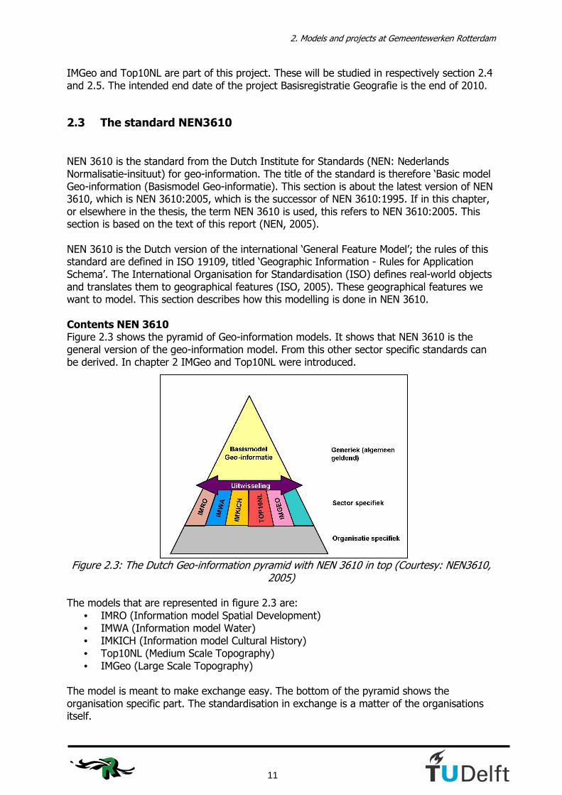
NEN 3610 is the standard from the Dutch Institute for Standards (NEN: Nederlands Normalisatie-insituut) for geo-information. The title of the standard is therefore ‘Basic model Geo-information (Basismodel Geo-informatie). This section is about the latest version of NEN 3610, which is NEN 3610:2005, which is the successor of NEN 3610:1995. If in this chapter, or elsewhere in the thesis, the term NEN 3610 is used, this refers to NEN 3610:2005. This section is based on the text of this report (NEN, 2005). NEN 3610 is the Dutch version of the international ‘General Feature Model’; the rules of this standard are defined in ISO 19109, titled ‘Geographic Information - Rules for Application Schema’. The International Organisation for Standardisation (ISO) defines real-world objects and translates them to geographical features (ISO, 2005). These geographical features we want to model. This section describes how this modelling is done in NEN 3610. Contents NEN 3610 Figure 2.3 shows the pyramid of Geo-information models. It shows that NEN 3610 is the general version of the geo-information model. From this other sector specific standards can be derived. In chapter 2 IMGeo and Top10NL were introduced.
Figure 2.3: The Dutch Geo-information pyramid with NEN 3610 in top (Courtesy: NEN3610, 2005)
The models that are represented in figure 2.3 are:
• IMRO (Information model Spatial Development) • IMWA (Information model Water) • IMKICH (Information model Cultural History) • Top10NL (Medium Scale Topography) • IMGeo (Large Scale Topography)
The model is meant to make exchange easy. The bottom of the pyramid shows the organisation specific part. The standardisation in exchange is a matter of the organisations itself.

Developing a vario-scale IMGeo using the constrained tGAP structure
12
The description of classes and their relationships is done in a UML class diagram. In the Object Constraint Language (OCL), which is defined as part of UML, constraints to the model can be added. The exchange in NEN 3610 takes place in GML. All objects in NEN 3610 are defined in the same way; for every object class there is a set of prerequisites, which can be related to the UML model, or give explanation to the position of the class in the model. Table 2.1 shows this standard presentation and description of a class.
Class content Explanation
Definitie Definition of the class Herkomst definitie The origin or source of the definition.
This position is only filled if an existing definition is used. Inwinningsregels Description of collection rules with respect to this class.
In NEN 3610 it is not possible to define collection rules. This can be done on sector level.
Generalisatie From which class this class is a generalisation? Specificatie From which class this class is a specification? Attributen The attributes defined for this class. Associaties With what classes this class has associations. Gebruik/voorbeelden Explanation of the use of this class.
Table 2.1: Presentation of a class in NEN 3610 NEN 3610 defines a super class object GeoObject, in which all objects are identified and some general attributes are defined. These attributes are attached to all objects and shown in table 2.2.
Attribute name Explanation
identificatie A unique identifier for a geo-object objectBeginTijd System-time on which the object emerges objectEindTijd System-time on which the object becomes invalid versieBeginTijd System-time on which this version of the object emerges versieEindTijd System-time on which this version of the object becomes invalid status The status connected to the life-cycle of a geo-object locatie Reference to the location of the geo-object
in terms of address or location description beginTijd Date on which the geo-object started to exist in reality EindTijd Date on which the geo-object ended to exist in reality naam Name of the object
Table 2.2: Attributes for the object GeoObject in NEN 3610 The geometry is not one of the attributes of the super class GeoObject. This is because at this level it is not possible to say how an object’s geometry is defined. The geometry of objects is therefore always directly or indirectly defined in the subclasses. NEN 3610 has 14 subclasses; not all these subclasses have to be used in the sector specific models. As we will see in section 2.6 sector models differ from each other. Only those classes in the sector models are used which are of use for the sector. NEN 3610 defines all subclasses or object classes which could emerge in the different sector models. The 14 object classes in NEN 3610 are mentioned in Dutch with between brackets their translation in English.
2. Models and projects at Gemeentewerken Rotterdam
13
• Weg (road) • Spoorbaan (railroad) • Water (water) • Terrein (terrain) • Gebouw (building) • Kunstwerk (civil work) • Waterkering (dike) • Leiding (utilities) • Inrichtingselement (topographical element) • RegistratiefGebied (registration area) • PlanologischGebied (planological area) • FunctioneelGebied (functional area) • GeografischGebied (geographical area) • Meting (measurement)
As shown in figure 2.3 the topographical models are not the only models derived from NEN3610. Since IMGeo and Top10NL are both topographical models defined with respect to the same standard, we should expect that they resemble a lot. In section 2.6 we will see whether this indeed is the fact. First we take a closer look at IMGeo and Top10NL in sections 2.4 and 2.5.
2.4 IMGeo and its implementation in Rotterdam
This section discusses IMGeo. IMGeo is the new model according to which the Rotterdam GBK will be made in the future. This section describes the model and the current status of the model. The text in this subsection comes sometimes from the report on IMGeo, version 1.0 (IMGeo, 2007). The author translated and edited the text in those cases. Other information comes from interviews with Rinske van Gosliga and Edim Hadziavdic. The section starts with the structure of IMGeo in subsection 2.4.1; the status of the model will be described in subsection 2.4.2. IMGeo is a model which in the first place has been created because 4 large municipalities in the Netherlands felt the need for large scale object-oriented geo-information. These municipalities initiated to make an information model, which would define and standardize the exchange of objects. These municipalities are Amsterdam, The Hague, Vlaardingen and Rotterdam.
2.4.1 Structure
The structure of objects in IMGeo will be described in this subsection. The focus will first be on the objects, later on the attributes. The model is fully described in IMGeo (2007). Objects In IMGeo a lot of different objects are taken into account. Some of them are area objects; others are line or point objects. All available main objects are listed; for every class the English translation is added between brackets. Some classes describe the situation as parts of an object. With roads for example normally the road objects are cut into pieces which go from one junction to the next; these are the road parts. The whole road object consists of

Developing a vario-scale IMGeo using the constrained tGAP structure
14
several road parts. The whole class diagram of the IMGeo model, which defines how the objects are related to each other, is provided in Appendix A. IMG_ GeoObject (object) This is the super class under which every object in IMGeo is situated. Its attributes are linked to every object in the model. Weg (road), Wegdeel (road part) These classes define all kinds of roads in the model; the object class road is the super class here. All roads can consist of several road parts. Spoorbaan (railroads), spoorbaandeel (railroad part) These classes define all railroads in the model; the object class railroad is the super class here. All railroads can consist of several railroad parts. Water (water), waterdeel (water part) These classes define all water in the model; the object class water is the super class here. All water objects can consist of several water parts. Terrein (terrain), terreindeel (terrain part) These classes define all terrains in the model; the object class terrain is the super class here. Terrains can consist of several terrain parts. Different types of land use are for example modelled in these classes. Kunstwerk (civil works), kunstwerkdeel (civil works part) These classes define all civil works in the model; the object class civil works is the super class here. All civil works can consist of several civil works parts. Examples of civil works to be modelled in this class are bridges and tunnels. Pand, verblijfsobject (buildings, residence objects) These classes define all buildings in the model. All definitions in this class are according to the regulations of the registration for buildings and addresses (BAG). In IMGeo only the geometry of the building and the ID of the buildings and their associated residence objects appear. Inrichtingselement (topographical elements) These classes define all elements which fit up the area. All kind of elements are meant here, for example traffic lights and lamp-posts. For the complete list of elements the reader is referred to the full report of IMGeo (IMGeo, 2007). Registratief gebied (registration area) The registration area is an abstract class. Here the space is subdivided in provinces, municipalities, places of residence, neighbourhoods, etc. IMGeo objects are used in the format of figure 2.4. The figure represents the form of an UML-class diagram in IMGeo.
Klassenaam
+attribuutnaam : <attribuutdomein> [multipliciteit]
Figure 2.4 Representation of an object in IMGeo
2. Models and projects at Gemeentewerken Rotterdam
15
Explanation of figure 2.4 – ‘Klassenaam’ = the name of the object class. – ‘attribuutnaam’ = the name of the attribute. – <attribuutdomein> = a reference to the acceptable values for this attribute, the domain. – [multipliciteit] = the number of values the attribute can take. Attributes Every object in IMGeo has a unique ID; this ID is the first and most important attribute of an object. Most attributes of objects in IMGeo are stored in the super class IMG_GeoObject. These attributes are:
• Object ID • Object Start time • Object End time • Version Start time • Version End time • Status • Location • Name
The start- and end time of objects are the time the object first appears and when it becomes invalid. The version time is the time an object is modified; the end time of this is when a new version of the object is created. The status of an object is connected to the life-cycle of the object. This consists of planned objects, existing objects and former objects. This temporal aspect in IMGeo allows to see how situations will be in the future and to recall earlier situations for e.g. juridical procedures. ‘Location’ describes the location of the object, not in coordinates but in words. The name of the object is for example the name of the street. In the different object classes several attributes appear frequently. These attributes are geometry and level. The attribute geometry defines whether the object can appear as area, line or point (or a combination of those). The attribute level defines on what relative level the object is situated in case more objects are situated on the same x-y-spot (e.g. when a bridge crosses a river). The ground level is taken as level 0. Objects underneath or above this level are numbered with respect to this ground level. For a full overview of all attributes the reader is referred to the report IMGeo (IMGeo, 2007).
2.4.2 Status of IMGeo
IMGeo has been initiated apart from the project Basisregistratie Geografie, but it actually can fit in very well. On the national level the need was felt to have a GBK which represents more than just geometry. IMGeo is an object-oriented model to which attributes can be assigned. In the first place it has been designed to improve the GBK-model, but eventually it might be used for other scales as well. The IMGeo model defines rules for data collection, but not for visualisation. This makes that the model is suitable as a basis for generalisation. At the Kadaster also plans are made for an information model, named IMTop, which is planned to start from scale 1:10,000. The current Top10NL is not seen as an information model by everyone, because it contains

Developing a vario-scale IMGeo using the constrained tGAP structure
16
specific visualisation rules for specific scales; in information models visualisation rules play a minor role. It might seem that IMGeo already is the solution to the generalisation problem, but in the first place IMGeo will be used as a means to produce a new object-oriented GBKN. For IMGeo currently (August 2007) pilots are being finalised which show to what extend the conversion of the current area data to IMGeo in GML works. These pilots are done in the municipalities of The Hague, Echt-Susteren and Almere. The Hague and Almere have been the most successful in executing the pilot. First a paper mapping was made and this has been implemented in GML. The data of Almere appeared to be the most useful, because it consists of a quite complete set of objects. This was used for further tests during this master thesis research. After finalising the pilots the model was submitted in the ‘GI beraad’, an organisation within the ministry of Spatial Development (VROM). After this it was placed in the pyramid of geo-information models of GeoNovum as shown in figure 2.3. GeoNovum is the organisation that will be responsible for the IMGeo model. The model will be frozen for at least two years, after this period it is possible to add or change things to the model. Rinske van Gosliga will probably take place in the committee to guard the model on behalf of Gemeentewerken Rotterdam. Beside the submission in the GI beraad the model will also be submitted by the standards forum of the Dutch ministry of Internal Affairs (Binnenlandse Zaken).
2.5 Top10NL and its implementation in Rotterdam
Within the organisation of Gemeentewerken Rotterdam there is a process going on for some years to come to delivering the KBK-R to the Dutch Cadastre. The KBK-R is a map drawn from aerial photographs. Objects don’t have any attributes, only a classification; this will be changed when going to Top10NL. This section describes the structure of Top10NL in 2.5.1 and the current status of implementing Top10NL in Rotterdam in subsection 2.5.2. Top10NL is the 1:10,000 map product of the Kadaster; it is the successor of the vector model Top10Vector. This product was divided into separate map sheets, which didn’t overlap. The new model Top10NL is object-oriented, has no separate sheets anymore and is defined under NEN 3610. Top10NL is expected to be a product which can form a bridge between several external geographical products, because of its object orientation. A lot of effort is also done to the visualisation of the product.
2.5.1 Structure
In the Top10NL attributes are connected to the objects, which is not the case in the KBK-R. Top10NL is based on the standard NEN 3610 and therefore the major object classes resemble very much to the major object classes in IMGeo, which was presented in section 2.4. Figure 2.5 shows the Top10NL object classes.

2. Models and projects at Gemeentewerken Rotterdam
17
Figure 2.5: Objects in Top10NL (Courtesy: Lentjes, 2007)
The object classes defined in Top10NL are:
• Wegdeel (road) • Spoorbaandeel (railroad) • Waterdeel (water) • Gebouw (building) • Terrein (terrain) • Inrichtingselement (topographical element) • Reliëf (isolines) • Registratief gebied (registration area) • Geografisch gebied (geographical area) • Functioneel gebied (functional area)
The full UML diagram of Top10NL is shown in Appendix B. Even though IMGeo and Top10NL are based on the same standard, the figure shows some differences. In section 2.6 an extended comparison between the models will be made.
2.5.2 Current situation
Since Top10NL is the authentic registration on topography, every governmental organisation is obliged to use Top10NL from 2010. The official release of Top10NL took place on January 1st 2008. The municipality of Rotterdam currently keeps its own KBK-R and the customers are satisfied about the quality and the actuality of this map product. Some features that are in the current KBK-R are not in the Top10NL.

Developing a vario-scale IMGeo using the constrained tGAP structure
18
The advantages of Top10NL with respect to the KBK-R are (Boelhouwer, 2006):
• Object orientation • Based on both national and international standards • Visualisation and objects are separated • Easy exchange between municipalities • History of objects is stored • Data model can be extended • Many applications due to large amount of attribute information
These are the advantages of Top10NL with respect to the KBK-R. When Top10NL was developed there was no object oriented model in The Netherlands. With IMGeo Top10NL is not unique in this anymore. In the first place Top10NL, as well as IMGeo, is a data model, therefore the visualisation of objects is separated from the object storage. The information in Top10NL can be very easily exchanged between municipalities and other users, because the methods for data collection are the same everywhere. What Top10NL doesn’t have, or doesn’t have filled, and what Rotterdam and its customers do require, is:
• Street names • Inner areas • High actuality • Plan topography
The street names are attributes of the roads in Top10NL, but they are not displayed on the map as in the KBK. It also appears that most of the attribute fields with street names are not filled in the Top10NL. The inner areas are displayed as buildings in Top10NL, but this is information the fire brigade wants to have to see where they can get access to a buildings. Also subsidies for boroughs are based on the KBK; with no inner areas the results of this will be very different. The actuality of the KBK is one year; the actuality of Top10NL is 2 years for roads and buildings; for the rest of the objects the actuality varies. Customers request an even more frequent update of the KBK. This is not possible because the aerial photographs are only made once a year. Plan topography could be inserted in the attribute ‘status’ in Top10NL, but it is not. The differences between the products are discussed by both parties and the idea of an extra layer for Rotterdam came up. This would mean that Rotterdam would produce and exchange the Top10NL according to the specifications of the Kadaster, but for internal use would add its own layer. A pilot with the Kadaster for these plans stocks, because the Kadaster is also in a reorganisation. However, it is a planned fact that Rotterdam will have Top10NL in their organisation from 2010, whether self-produced or produced by the Kadaster. Whether this will be with or without an extra layer and whether they will deliver the data to the Kadaster or vice versa remains unknown for now.

2. Models and projects at Gemeentewerken Rotterdam
19
2.6 Differences between IMGeo and Top10NL
This section will discuss the differences there are between IMGeo and Top10NL. This will be done in two separate subsections, because the differences appear to be at two different levels. Subsection 2.6.1 discusses the differences in classes and attributes that are collected. Subsection 2.6.2 is on the differences in geometry.
2.6.1 Classes and attributes
IMGeo and Top10NL are based on the same standard: NEN 3610. Due to their different history they are still built up differently. IMGeo is built on the basis of the specifications of the GBKN and can be seen as a polygon-GBKN; Top10NL is the object-oriented successor of Top10Vector. To discover the differences between the models we take the top-down approach; we start at the top of the hierarchy and end with the most detailed attributes of both models. GeoObject The most important class in both models is the GeoObject. In section 4.1 we saw the attributes of the GeoObject being defined according to NEN 3610. Table 4.3 shows what attributes the GeoObject has in both sector models compared to the initial generic model. This table is to be read horizontally; the corresponding attributes in the other models are to be found on the same line. Table 2.3 shows that IMGeo differs from NEN 3610 only in the attributes beginTijd and eindTijd; those are not included in IMGeo. For Top10NL there are more differences; the attributes beginTijd and eindTijd are not included as well, but also the status, location and name of the objects are not obligatory attributes in the Top10NL GeoObject. Instead Top10NL has other meta information: brontype (source type), bronbeschrijving (source description), bronactualiteit (source actuality), bronnauwkeurigheid (source accuracy) and dimensie (dimension). These attributes all tell something about the way the data has been collected. The attributes status and name are in Top 10NL not in the superclass GeoObject, but in the individual objects. This is because the domain of values of these attributes can differ per object class in Top10NL.

Developing a vario-scale IMGeo using the constrained tGAP structure
20
NEN3610 IMGeo Top10NL
identificatie identificatie identificatie objectBeginTijd objectBeginTijd objectBeginTijd objectEindTijd objectEindTijd objectEindTijd versieBeginTijd versieBeginTijd versieBeginTijd versieEindTijd versieEindTijd versieEindTijd status status locatie locatie beginTijd eindTijd naam naam brontype bronbeschrijving bronactualiteit bronnauwkeurigheid dimensie
Table 2.3 Comparison of attributes in GeoObject Object classes As already seen in section 2.3 a sector model does not necessarily contain all classes mentioned. This is where we will see the first differences in the objects that are collected. Table 2.4 shows the classes that are defined in both models. The build up is the same as table 2.3.
NEN3610 IMGeo Top10NL
Weg Weg Wegdeel Spoorbaan Spoorbaan Spoorbaandeel Water Water Waterdeel Terrein Terrein Terrein Gebouw Pand, Verblijfsobject Gebouw Inrichtingselement Inrichtingselement Inrichtingselement Kunstwerk Kunstwerk RegistratiefGebied RegistratiefGebied RegistratiefGebied Leiding FunctioneelGebied FunctioneelGebied GeografischGebied GeografischGebied PlanologischGebied RegistratiefGebied Meting Reliëf
Table 2.4 Comparison of classes in IMGeo and Top10NL
Table 2.4 shows that different approaches have been taken to model the real world. In this respect IMGeo models buildings in the same way as NEN 3610, whereas Top10NL classifies them as they did in Top10Vector. This appears to give lots of differences in the list of attributes of both models. The class ‘Reliëf’ is also a class which is not modelled in IMGeo and NEN 3610 and can also be seen as being historical. The classes Geographical, Planological and Functional area have all not been modelled in IMGeo; geographical area is too broad for municipal purposes, planological area’s (spatial development areas) are interesting for other models under NEN3610. Functional area can be seen as an extension of the class ‘Terrein’, the geometry of these areas however is hard to determine. For example the boundary of a cemetery is not collected as area object in
2. Models and projects at Gemeentewerken Rotterdam
21
Top10NL, but only as point object somewhere in the area to be able to label it. These are all reasons for less object classes in IMGeo. The class ‘Kunstwerk’ is not modelled as a separate class in Top10NL. All objects belonging to this class in IMGeo are in the Top10NL class ‘Inrichtingselementen’. A remarkable fact is that in Top10NL the classes road, railroad and water are modelled as parts of the roads and not with a separate aggregation class above it. This means that separate road parts can’t be identified to be belonging to the same road based on their common ID. However, this can be done by querying objects through their street names. Unfortunately, the attribute field with street names is hardly filled and therefore this is not a very good alternative in the current product. Attributes and attribute values We already discovered that the attributes under GeoObject in both models differ from each other. However not obliged in GeoObject, attributes like ‘status’ do exist in Top10NL on another place. This means that the individual objects normally have a status with values that can differ per object class in Top10NL. In the appendices C and D an analysis is made of which attributes exist in which models. This analysis was done for the project IMTop, which will be introduced in section 2.7. One of the most striking differences in the attributes is between the object class ‘Gebouw’ (Top10NL) and ‘Verblijfsobject’ (IMGeo); ‘Verblijfsobject’ is according to the definitions of the BAG and ‘Gebouw’ is mapped according to the mapping standards in Top10NL, which means that an inaccuracy of 4 meters is allowed. Due to the fact that BAG is being followed in IMGeo no attributes besides the building ID, the residence object ID, the geometry and the relative height are stored. In Top10NL also for instance the type of the building and the ‘height class’ (hoogteklasse) are taken into account. Another important difference appears in the object class ‘Inrichtingselementen’ or topographical elements. The attribute values in this class differ very much from each other. The reason for this can be also found in the different backgrounds of the models. The build up of this class is also different in the different models. In Top10NL the topographical elements are all attribute values of the attribute ‘type inrichtingselement’, while in IMGeo the topographical elements are first subdivided in 11 subclasses. In these 11 subclasses the attribute ‘type (name of subclass)’ defines the attribute value of the subclass of the topographical element. The 11 subclasses are:
• Bak (bin) • Bord (sign) • Installatie (installation) • Kast (case) • Mast (pylon) • Overig Bouwwerk (other building) • Paal (post) • Put (well) • Scheiding (separation) • Straatmeubilair (street furniture) • Spoorrail (railroad)
Developing a vario-scale IMGeo using the constrained tGAP structure
22
In the object class on topographical elements we can see very well that IMGeo is mainly based on the municipal registrations, on what they want to register. Top10NL has a more regional character, which can be seen through attribute values like high-voltage lines, which can cross through whole municipalities without a starting point and an ending point, but which have importance on a smaller scale.
2.6.2 Geometry
Appendices C and D show respectively the geometry of all attribute values in IMGeo and Top10NL. The distinction between points, lines and polygons is made here. For every object it is judged whether it is allowed to appear as point, line, polygon or a combination of them. The advantage with these models is that they both have lots of polygons. For generalisation purposes in the tGAP structure this is necessary. The similarities are for example shown in the object classes building and terrain. These objects can in both models only appear as polygons. Also the objects in the class ‘RegistratiefGebied’ are all polygons in IMGeo, in Top10NL they are allowed to be point objects for labelling purposes; these point objects are easy to interpret as belonging to a wider area object, although this might not be collected. The differences show up in the object classes with roads, railroads, water and topographical elements. The object class ‘Kunstwerk’ in IMGeo is for simplicity reasons taken into account with the topographical elements. The elements in the classes roads, railroads and water have some similarities. In IMGeo they are always polygon objects, because at this large scale there is no need to simplify them. In Top10NL it depends on the importance and the width of the road, railroad or water whether it is represented as a line or a polygon object. Roads with a width smaller than 2 meters are point- or line objects in Top10NL. Railroad objects are always point- or line objects. Road- and railroad objects can be point objects in case of for example a railway- or a gas station. Water is a line object if its width is less than 6 meters. In the current tGAP structure there is no solution for the conversion of polygon features to line features. This could fit in the tGAP structure and progress is being made to implement this. Within this research this hasn’t been taken into account. There is another striking difference in the way railroads are collected in both models. In IMGeo the rail itself is collected as a topographical element and the area on which the rail lies is collected as an object in the sub-object class ‘Railroad part’. In Top10NL this situation is exactly reversed. The lesson that can be learned from this example is that even the smallest details of the collection of objects can differ between models. This problem now applies when comparing Top10NL and IMGeo, both originating from NEN3610; the modelling of the models can really differ in every aspect. The geometrical appearance of lots of topographical elements also differs, mainly because the elements in the models itself differ a lot.

2. Models and projects at Gemeentewerken Rotterdam
23
2.7 Related projects in The Netherlands
Outside Rotterdam also projects take place which focus on the same subject of generalising large scale topographical data. They don’t take place in Rotterdam, but during this research a contribution has been given to and ideas could be obtained from some of these projects. It is worth mentioning them here, because they also give an indication of the relevance of this research within a broader perspective. This section takes a look at three ongoing projects in the field of map generalisation in The Netherlands. The first two projects are executed by consortia, which will be introduced in this section. Subsection 2.7.1 is about the project IMTop, subsection 2.7.2 is about a part of the Ruimte voor Geo-informatie (RGI)-project DURP ondergronden. Subsection 2.7.3 takes a look at the project to insert GBKN buildings directly into the Top10NL.
2.7.1 IMTop
The project IMTop is a joint project by the Dutch Cadastre (Kadaster), ITC Enschede (International Institute for Geo-Information Science and Earth Observation) and TU Delft. Its aim is to combine the small scale datasets of the Kadaster through generalisation. All object classes should form at certain scale levels a logical and consistent set of topographical elements. The model therefore needs to know what classes need to be displayed at what scale and what level of detail is requested for an object class at a certain scale. The scales that have to be modelled within IMTop are at least 1:10k, 1:25k, 1:50k, 1:100k, 1:250k, 1:500k and 1:1000k. These scales are necessary for the law on the authentic registrations, the scales 1:250k and 1:1000k are also needed for the European products respectively EuroRegionalMap and EuroGlobalmap. The project has defined some requirements to which the model has to satisfy. A requirement of the Kadaster is that the model of Top10NL should be unchanged. There are also requirements with respect to the generalisation procedures. One of these is that IMTop should not only be suitable for the scales mentioned, but should have a possible vario-scale output for future products (Stoter et al., 2007). The master thesis project of the author of this report is about generalisation of even larger scales than mentioned in this project. Because generalisation from a level 1:1,000 is even more interesting than when starting from 1:10,000 this master thesis project is seen as a useful addition to this generalisation project by this project group, because the scale 1:1,000 contains even more detailed geometry.
Developing a vario-scale IMGeo using the constrained tGAP structure
24
2.7.2 DURP Ondergronden
Another interesting development is to be found in the project DURP Ondergronden. This project is mainly about generalising topographical planning maps. It is executed by a large number of parties, which are:
• Bentley Systems Netherlands • ESRI Nederland • ITC Enschede • Kadaster • Landelijk Samenwerkingsverband GBKN (LSV-GBKN) • NedGraphics • Sense Organisatie & Coaching • Technische Universiteit Delft
The objective of this research project is “to generate and use base maps for integrated querying of digital physical plans”. Because the research was mainly focussing on maps of the Kadaster a subproject is defined in which the LSV-GBKN can participate. This subproject is about generating Top10NL from IMGeo, which is exactly the theme of the master thesis as well. This master thesis report therefore will be the starting point for this subproject. A large portion of the work done for this project DURP Ondergronden can also be addressed to the RGI project 223 on Usable Mobile Maps (or MobiMaps).
2.7.3 GBKN buildings in Top10NL
In section 2.2 the BAG already was introduced. It was stated that the geometry of the buildings at scale 1:1,000 is needed, because this provides enough detail. For this reason the geometry of buildings in Top10NL is not accurate enough. Since Top10NL is an authentic registration it preferably wants to have a connection to other authentic registrations like the BAG. Therefore currently it is being investigated whether it would be possible to put the GBKN buildings in Top10NL without any form of generalisation (Hidding and Uitermark, 2006). Hampe states that intermediate scale layers will be necessary to have the correct amount of detail when the scale increases with a factor 2 to 4 (Hampe, 2003). The level of detail of GBKN buildings in the Top10NL is too much. If this project leads to implementation this has also direct consequences for this research. However, so far it is not taken into account.

2. Models and projects at Gemeentewerken Rotterdam
25
2.8 Conclusions
This chapter introduced the situation in Rotterdam. It is shown that this is a dynamic situation in which several processes take place. The vision in Rotterdam is clearly to come to a situation in the future where data is collected once and used for many purposes, this is what the project ‘Basisregistraties’ is all about. The progress of implementing IMGeo in Rotterdam is clearly there, but not enough in time to take place in this research. Nevertheless, Rotterdam is one of the municipalities that initiated IMGeo, this makes that the connection from Rotterdam to the subject remains. Pilot data from the municipality of Almere can be used instead and the results can be projected on the Rotterdam situation. For Top10NL we have seen that there is a necessity to implement this into the organisation of Gemeentewerken Rotterdam due to legal obligations in the near future. To be able to use geographical data for many purposes generalisation is needed. Chapter 3 introduces the methodology to do so, chapter 4 and 5 describe how the models that were introduced in this chapter are used to build a way to reach this target of the project ‘Basisregistraties’.

Developing a vario-scale IMGeo using the constrained tGAP structure
26

3. Research methodology
27
3. Research methodology In this brief chapter the vision on the research methodology is explained. The chapter starts with an introduction to the constrained tGAP structure in section 3.1 and after that explains the research approach in section 3.2
3.1 The constrained tGAP structure
In a literature study (Hofman, 2007) Hofman arguments that for the generalisation proposed for this thesis work the tGAP structure is most suitable. The tGAP is fast, scale independent and stores the geometry of objects only once. These conditions make the tGAP very suitable. In the same literature study the proposal is done to work out the constrained tGAP structure (Haunert et al., 2007) with IMGeo as the basis and the Top10NL as constraint. This section will introduce this constrained tGAP structure. The idea of the constrained tGAP is build upon the general idea of the tGAP structure (Van Oosterom, 1993 & 2005, Van Oosterom et al., 2006). The idea of the constrained tGAP tree is that the tGAP is not built from the largest scale alone, but that it is built between two map scales. Between these map scales the tGAP structure can than be built to show which objects are aggregated. Figure 3.1 shows the schematic process of the tGAP structure. In the tGAP structure the geometry of features is first to be transformed into a topological model, which consists of nodes, edges and faces. With the tGAP algorithm first the least important face is selected and merged with one of its neighbours. From this a new face originates. When repeating this process a tree of merged and emerged faces can be made. The bottom of this tree shows all the objects at the largest (most detailed) scale; going to the top of this tree details are left out and at the top only one object is left. Every level of detail in-between these scales can be requested and be presented as shown in figure 3.1
Figure 3.1: The process of the tGAP structure (figure courtesy lower right part: Haunert et
al., 2007)

Developing a vario-scale IMGeo using the constrained tGAP structure
28
The constrained tGAP structure builds a collection of small tGAP trees; the merging of objects stops when the level of detail from the constraint has been reached. Figure 3.2 shows how this works for one part.
Figure 3.2: The build up of the constrained tGAP structure for a single region (figure
courtesy: Haunert et al., 2007) In step 0 of figure 3.2 the least important feature 3 is selected as the least important feature. Feature 4 is selected as the most compatible neighbour. These two features are merged to form a new feature 5. Feature 3 and 4 are not erased from the tGAP, they get the importance_high value 1, which means that they were merged after step 1. Feature 5 gets the importance_low value 1, which means that it originated after step 1. Not the importance value is stored as importance_high (or imp_high) and importance_low (or imp_low), but the iteration step; this is easier to implement. This process repeats until there are no merge able objects anymore in the dataset. The attributes imp_high and imp_low tell at which step an object appears or disappears from the map. Therefore, by querying the database for a certain importance value, the map can be viewed at every requested level of detail. Objects in a smaller scale appear as large objects when put in a large scale map. They can be seen as regions in that map. The purpose of this research is to assign objects in the large scale dataset to regions in the small scale dataset. Because the region also is an object, the region-object can be seen as the top object of a small tGAP-‘branches’ and the objects inside the tGAP can be forced to merge to the class of this top object. If datasets are combined the geometry will not match everywhere. To show this statistics can be made from the overlay of the maps; they show where objects differ and which object combinations are aggregated more than others. With this information on aggregations the importance factors and class compatibility functions can be better determined; in the current tGAP they have to be estimated.

3. Research methodology
29
Class weights In the tGAP structure the weights of classes are hard to determine. The importance of an object is currently being calculated according to equation 3.1.
weight(x)classarea(x)(x)importance ⋅=
Equation 3.1: Equation of the importance function in the tGAP structure
In the current tGAP structure (Van Oosterom, 2005) the class weights are all set to one, which means that the importance is only determined by the area size. When inserting a constraint the structure knows what the final top object of the tGAP branch has to be. With information of the output we improve the class weights for at least this specific case with IMGeo and Top10NL. Van Putten (1998) also investigated proper class weights. Future research will nevertheless be necessary to determine whether these class weights are also of use for other datasets. Compatibility functions For the compatibility functions the tGAP structure uses a table with similarities. This table defines for all classes a certain cost for transition. For every possible transition class a ‘cost’ is to be determined, which is done in chapter 5.
MostCompNeighbour(y) = miny(cost(class(x)–class(y)) ·area(y))
Equation 3.2: Equation of the compatibility function in the tGAP structure.
This cost will first be estimated for all possible combinations of object classes in the table compatibilites. If the results are not satisfactory, the values of this table might be changed by statistical and empirical analysis. Other compatibility functions also make use of the length of the common boundary, this is not done in this function. Final goal From the constrained tGAP structure general rules can be defined for the generalisation parameters in the tGAP structure. The related goal in this is to get to a situation in which the tGAP structure can be better built and maintained without constraints. For the master thesis the 1:1,000 IMGeo map and the 1:10,000 Top10NL are used to build this constrained tGAP. IMGeo is in this case the basis and Top10NL forms the initial constraint. The representation resulting from the tGAP at 1:10,000 should than be acceptable with respect to the current 1:10,000 map. The full code of the constrained tGAP structure used in this research is provided in Appendix G.

Developing a vario-scale IMGeo using the constrained tGAP structure
30
3.2 Application of the constrained tGAP structure in this research
The approach of this research has already been explained in the introduction chapter. This section is a guide through the different steps that have been taken during the research. Data preparation The IMGeo- and Top10NL datasets that were used for this research needed to be prepared to go into the tGAP structure. Taking into account the specifications of IMGeo and Top10NL it was supposed that it wouldn’t take to much effort to get to an area partition, which is necessary for the tGAP structure. This hasn’t been the case. Chapter 4 shows what operations were necessary to come to a good basic dataset. Assign a region to an IMGeo object A region needs to be assigned to an IMGeo object, because the data preparation and the comparison of the two models showed that there were a lot of geometrical differences. It was supposed that the assigning of a region could be done by making a model in ArcGIS. Part of the joining of the objects was done in an ArcGIS model, but because this program offered not enough possibilities the programming language Python was used further. With two scripts the IMGeo objects were assigned to a final region. This is all to be read in chapter 5 in which four methods are described giving different results in the generalisation structure. Assigning class weights and creating the compatibility matrix The first results of the tGAP tree are collected with estimates. After these results are compared to the existing Top10NL conclusions can be drawn with respect to values in these matrices which need to be changed. This is described in chapter 6. These matrices are implemented as Oracle tables. Getting results using the constrained tGAP structure The results using the constrained tGAP structure are described in sections 5.4 - 5.7. Using a PL/SQL script the tGAP-branches are built. In chapter 6 the results are interpreted for the assigning of better class weights and compatibility values. This process endures until the results are satisfying. Finally the methods are tested on a larger dataset.
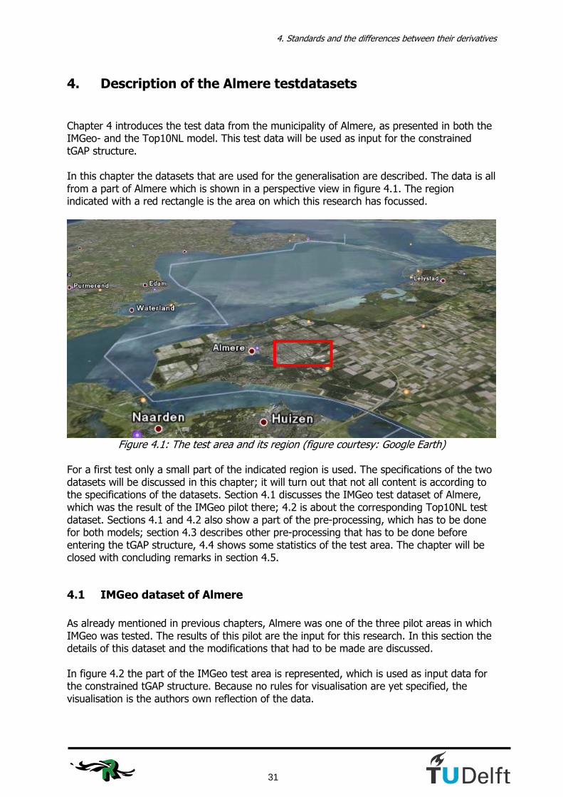
4. Standards and the differences between their derivatives
31
4. Description of the Almere testdatasets Chapter 4 introduces the test data from the municipality of Almere, as presented in both the IMGeo- and the Top10NL model. This test data will be used as input for the constrained tGAP structure. In this chapter the datasets that are used for the generalisation are described. The data is all from a part of Almere which is shown in a perspective view in figure 4.1. The region indicated with a red rectangle is the area on which this research has focussed.
Figure 4.1: The test area and its region (figure courtesy: Google Earth)
For a first test only a small part of the indicated region is used. The specifications of the two datasets will be discussed in this chapter; it will turn out that not all content is according to the specifications of the datasets. Section 4.1 discusses the IMGeo test dataset of Almere, which was the result of the IMGeo pilot there; 4.2 is about the corresponding Top10NL test dataset. Sections 4.1 and 4.2 also show a part of the pre-processing, which has to be done for both models; section 4.3 describes other pre-processing that has to be done before entering the tGAP structure, 4.4 shows some statistics of the test area. The chapter will be closed with concluding remarks in section 4.5.
4.1 IMGeo dataset of Almere
As already mentioned in previous chapters, Almere was one of the three pilot areas in which IMGeo was tested. The results of this pilot are the input for this research. In this section the details of this dataset and the modifications that had to be made are discussed. In figure 4.2 the part of the IMGeo test area is represented, which is used as input data for the constrained tGAP structure. Because no rules for visualisation are yet specified, the visualisation is the authors own reflection of the data.
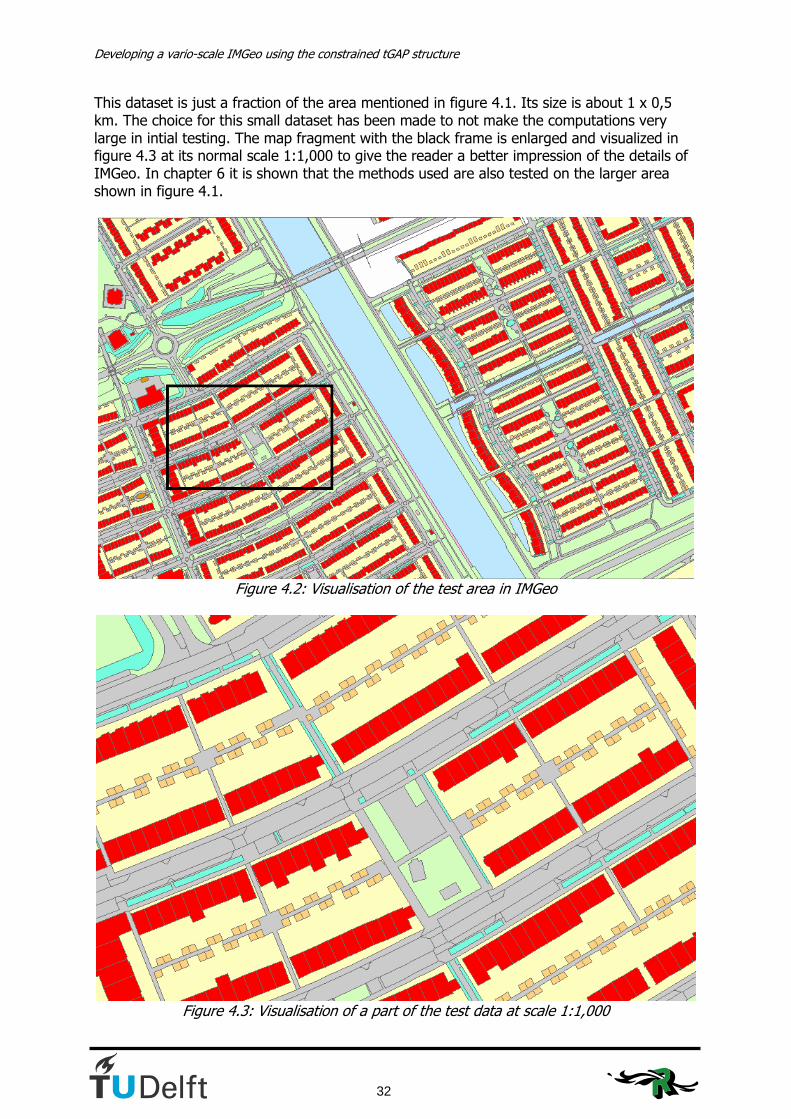
Developing a vario-scale IMGeo using the constrained tGAP structure
32
This dataset is just a fraction of the area mentioned in figure 4.1. Its size is about 1 x 0,5 km. The choice for this small dataset has been made to not make the computations very large in intial testing. The map fragment with the black frame is enlarged and visualized in figure 4.3 at its normal scale 1:1,000 to give the reader a better impression of the details of IMGeo. In chapter 6 it is shown that the methods used are also tested on the larger area shown in figure 4.1.
Figure 4.2: Visualisation of the test area in IMGeo
Figure 4.3: Visualisation of a part of the test data at scale 1:1,000
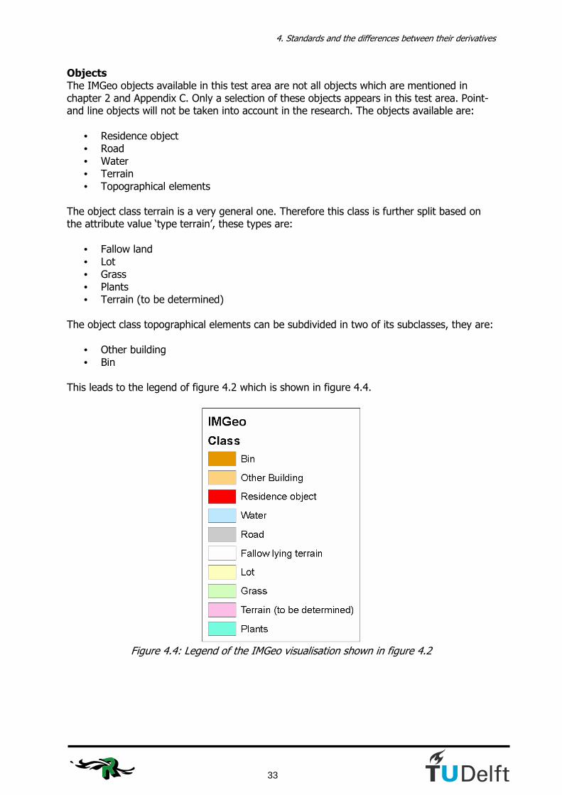
4. Standards and the differences between their derivatives
33
Objects The IMGeo objects available in this test area are not all objects which are mentioned in chapter 2 and Appendix C. Only a selection of these objects appears in this test area. Point- and line objects will not be taken into account in the research. The objects available are:
• Residence object • Road • Water • Terrain • Topographical elements
The object class terrain is a very general one. Therefore this class is further split based on the attribute value ‘type terrain’, these types are:
• Fallow land • Lot • Grass • Plants • Terrain (to be determined)
The object class topographical elements can be subdivided in two of its subclasses, they are:
• Other building • Bin
This leads to the legend of figure 4.2 which is shown in figure 4.4.
Figure 4.4: Legend of the IMGeo visualisation shown in figure 4.2
Developing a vario-scale IMGeo using the constrained tGAP structure
34
Pre-processing To use the data in the tGAP structure the data needs to be an area partition, which means that there are no overlapping areas and no gaps in the dataset. This is not the case in the pilot IMGeo data of Almere; this data set consists of separate layers containing one object class, which overlap in several places. Therefore modifications to the data where necessary to make it a partition. Operations in ArcGIS were done to do this, these operations will be discussed. In the final version of IMGeo it is stated that the polygon objects at level 0 have to form an area partition. Some objects are not part of the area partition at level 0, they are:
• Registration area • Buildings (roof print) • Civil works • Other objects
Registration areas are not part of the partition at level 0. There is no decision yet about the level they will be at, but probably this will be about level -10. The footprint of buildings is part of the partition in IMGeo. However, the roof prints of buildings, which are collected in Top10NL, are not. Therefore, if for tGAP generalisation the roof prints of buildings have to be taken into account, a new partition has to be made. The roof print of buildings will standard get about level 10. In the test dataset of the municipality of Almere these roof prints are not available. Civil works are normally placed at the level 1. If for example a bridge is going over the water, then the water has level 0, the bridge has level 1 and the road on the bridge has level 2. For all other objects the same holds as for civil works; if the object is no part of level 0, then the object is no part of the area partition as well. The above given examples are not provided in this test dataset; only a small amount of objects is provided and all objects got level 0. The following rules were applied when making the IMGeo test data an area partition. The hierarchy is in short:
• If ‘Terrain’ and another object overlap, the terrain part is erased. • If ‘Water’ and ‘Road’ overlap, the water part is erased. • If ‘Road’ and ‘Other building’ overlap, the road part is erased.
The hierarchy is mainly based on the fact that a map user gets a view from above; this is basically the idea of this hierarchy. A building stands on the terrain, a road lies over a canal (exception: aqauduct), etc. The details of these actions are explained with use of figure 4.5 and 4.6.

4. Standards and the differences between their derivatives
35
Figure 4.5: The first four erase actions in the ArcGIS model
Figure 4.6: The other two erase actions and the merge operation in the ArcGIS model

Developing a vario-scale IMGeo using the constrained tGAP structure
36
The operations which add a feature class to a geodatabase do not need discussion, they are the initial load of a feature class to the geodatabase. The other operations in the figures 4.5 and 4.6 and the hierarchy they imply will be discussed beneath:
• Erase: Road objects are erased under the other building objects. This is an exceptional overlap; it only appears 2 times in the test data set.
• Erase (2): Water objects are erased under road objects. This means that bridges get priority above the water underneath it.
• Erase (3): Terrain objects are erased under road objects. The road is lying on the terrain.
• Erase (4): Water objects are erased under terrain objects. This is the only position where terrain is put higher in the hierarchy, because it is supposed that the water runs under the terrain here. This is a very rare occasion as well. It only happens near bridges.
• Erase (5): Terrain objects are erased under residence objects. Residence objects get priority here, because they lie on the terrain.
• Erase (6): Terrain objects are erased under other building objects. Other building objects get priority, because they lie on the terrain.
• Merge (2): The merge operation merges all the processed IMGeo shapefiles to one shapefile.
What was also discovered was that about 100 objects existed double in the database with other ID’s. These are errors in the data due to the fact that no relative height levels were used. The double objects were for the largest part small area objects on crossings. To still make the area a partition one of these doubled objects was removed. To check whether the area really was a partition after all these actions the ArcGIS topology check was done. This operation checks for overlapping areas. Since most municipalities that want to work with IMGeo still have to do the conversion, this is one of the things that needs to be checked. For Almere it appeared that the data didn’t apply to all IMGeo regulations at once.

4. Standards and the differences between their derivatives
37
4.2 Top10NL dataset of Almere
The Top10NL dataset of the same part of Almere as in figure 4.3 is shown in figure 4.7.
Figure 4.7: Visualisation of the test area in Top10NL
Like in section 4.1 with IMGeo the details of the Top10NL dataset are discussed. Objects As in the IMGeo case the set of objects is not the possible set of classes from the model as mentioned in chapter 2 and Appendix D. This is just because most objects don’t exist in this area. The object classes that are available in the test area are:
• Building • Water • Road • Terrain
Also here the object class terrain is split into several terrain types based on the attribute values of ‘type terrain’, they are:
• Grassland • Wood • Other terrain
This leads to the legend of figure 4.7 which is shown in figure 4.8.

Developing a vario-scale IMGeo using the constrained tGAP structure
38
Figure 4.8: Legend of the Top10NL visualisation shown in figure 4.7.
Area Partition The objects in Top10NL are not an area partition. The difference with the previously treated IMGeo is that Top10NL is not even meant to be an area partition; the different object classes are separated layers which can overlap. For the tGAP structure however this is required. To make this dataset an area partition, operations in ArcGIS were done. The above described situation leads to a serious problem. We want to generate Top10NL data from IMGeo data, but through the tGAP structure we will never be able to return to a dataset which is not an area partition. The Kadaster will never accept this as a good replacement for the current Top10NL. The product specifications of theTop10NL might be changed to come to a situation in which the tGAP can produce the Top10NL.

4. Standards and the differences between their derivatives
39
The following rules were applied when making the Top10NL test data an area partition
• If ‘Terrain’ and another object overlap, the terrain part is erased. • If ‘Water’ and ‘Road’ overlap, the water part is erased.
The details of these rules are explained with use of figure 4.9
Figure 4.9: Erase operations in Top10NL in ArcGIS Modelbuilder
• Erase (7): Water objects are erased under road objects. This means that bridges get
priority above the water underneath it. • Erase (8): Water objects are erased under terrain objects. This is the only position
where terrain is put higher in the hierarchy, because it is supposed that the water runs under the terrain here. This is a very rare occasion as well. It only happens near bridges.
• Erase (9): Terrain objects are erased under road objects. The road is lying on the terrain.
• Erase (10): Terrain objects are erased under building objects. Building objects get priority here, because they lie on the terrain.
• Merge: The merge operation merges all the processed Top10NL shapefiles to one shapefile.
4.3 Further pre-processing of the test datasets
Class names Before being merged the shapefiles need a class name. This seems obvious, but because of the fact that the shapefiles are separated files, the mentioning of a class, which is necessary in the tGAP structure, has to be added. This also makes that the objects are distinguishable when they are merged.

Developing a vario-scale IMGeo using the constrained tGAP structure
40
Object ID’s With every operation in ArcGIS the feature ID’s of the new shapefile change. For this reason we need stable identifiers. In the IMGeo model this could be the GML-ID or the ‘Identificatie’. Because an identifier for residence objects was not yet implemented for the test area, this part of the column was empty and therefore this column was useless as identifier. The column with GML-ID’s was not filled in the test data set. Normally the value of this attribute would serve well as an identifier. Because working without an identifying attribute is not an option, the feature ID’s of the merged IMGeo objects were manually copied to the column GML-ID and this column is during the rest of the operations used as identifier. In the Top10NL model there is the identifying column ‘IDENT’. These identifiers have the form NL.TOP10NL.(9 digits). Because this identifier is used as input for a loop in the further processing in chapter 5 and files are given names with this identifier in it, it was not good to have identifiers with dots in it. Because the first part doesn’t really identify the objects, except for mentioning that it is a Top10NL object, the object identifier for Top10NL has become a column named Top10ID, which only has the last 9 digits of the former identifying code. Within this research the first part of the identifier wasn’t needed; in other cases of course this can be necessary. Object ID’s are known to be unique. However, there are some situations in the test data set where the object ID’s of the Top10NL dataset are not unique, this is of course not allowed to happen. One of these situations is at the only bridge in the test data set as is shown in figure 4.10. The reason why these situations appear is because of the relative height. There is another road going underneath the bridge which has the relative height -1. Because we want to end the pre-processing with an area partition all the objects with a relative height ≠ 0 have to be removed. What remains is 3 objects with the same ID, as can be seen in figure 4.10; the parts that cross the intersecting road are separate objects. These remaining objects are manually merged with the ArcGIS operator ‘dissolve’ to solve this problem.
Figure 4.10: ‘Non-unique’ Top10ID’s in the test data set
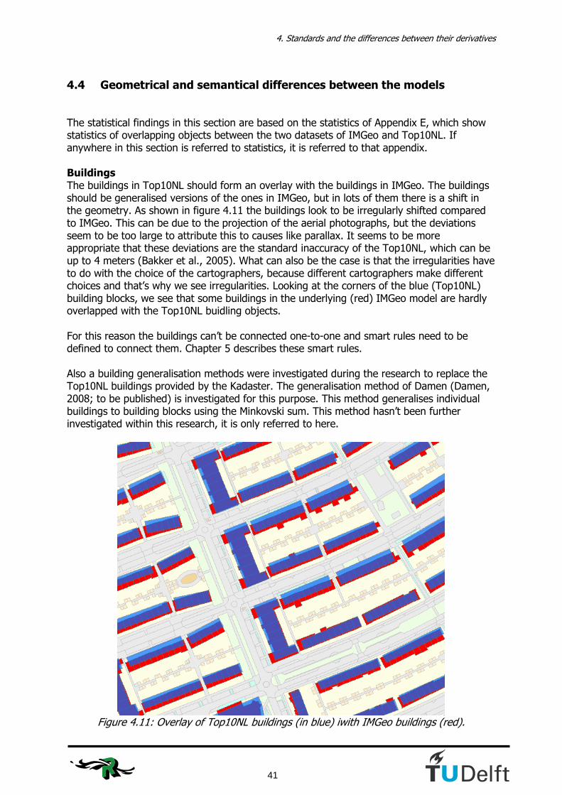
4. Standards and the differences between their derivatives
41
4.4 Geometrical and semantical differences between the models
The statistical findings in this section are based on the statistics of Appendix E, which show statistics of overlapping objects between the two datasets of IMGeo and Top10NL. If anywhere in this section is referred to statistics, it is referred to that appendix. Buildings The buildings in Top10NL should form an overlay with the buildings in IMGeo. The buildings should be generalised versions of the ones in IMGeo, but in lots of them there is a shift in the geometry. As shown in figure 4.11 the buildings look to be irregularly shifted compared to IMGeo. This can be due to the projection of the aerial photographs, but the deviations seem to be too large to attribute this to causes like parallax. It seems to be more appropriate that these deviations are the standard inaccuracy of the Top10NL, which can be up to 4 meters (Bakker et al., 2005). What can also be the case is that the irregularities have to do with the choice of the cartographers, because different cartographers make different choices and that’s why we see irregularities. Looking at the corners of the blue (Top10NL) building blocks, we see that some buildings in the underlying (red) IMGeo model are hardly overlapped with the Top10NL buidling objects. For this reason the buildings can’t be connected one-to-one and smart rules need to be defined to connect them. Chapter 5 describes these smart rules. Also a building generalisation methods were investigated during the research to replace the Top10NL buildings provided by the Kadaster. The generalisation method of Damen (Damen, 2008; to be published) is investigated for this purpose. This method generalises individual buildings to building blocks using the Minkovski sum. This method hasn’t been further investigated within this research, it is only referred to here.
Figure 4.11: Overlay of Top10NL buildings (in blue) iwith IMGeo buildings (red).
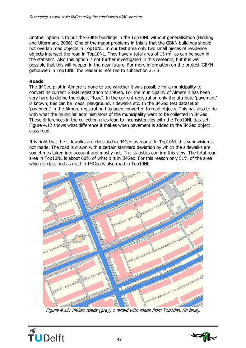
Developing a vario-scale IMGeo using the constrained tGAP structure
42
Another option is to put the GBKN buildings in the Top10NL without generalisation (Hidding and Uitermark, 2006). One of the major problems in this is that the GBKN buildings should not overlap road objects in Top10NL. In our test area only two small pieces of residence objects intersect the road in Top10NL. They have a total area of 13 m2, as can be seen in the statistics. Also this option is not further investigated in this research, but it is well possible that this will happen in the near future. For more information on the project ‘GBKN gebouwen in Top10NL’ the reader is referred to subsection 2.7.3. Roads The IMGeo pilot in Almere is done to see whether it was possible for a municipality to convert its current GBKN registration to IMGeo. For the municipality of Almere it has been very hard to define the object ‘Road’. In the current registration only the attribute ‘pavement’ is known; this can be roads, playground, sidewalks etc. In the IMGeo test dataset all ‘pavement’ in the Almere registration has been converted to road objects. This has also to do with what the municipal administrators of the municipality want to be collected in IMGeo. These differences in the collection rules lead to inconsistencies with the Top10NL dataset. Figure 4.12 shows what difference it makes when pavement is added to the IMGeo object class road. It is right that the sidewalks are classified in IMGeo as roads. In Top10NL this subdivision is not made. The road is drawn with a certain standard deviation by which the sidewalks are sometimes taken into account and mostly not. The statistics confirm this view. The total road area in Top10NL is about 60% of what it is in IMGeo. For this reason only 51% of the area which is classified as road in IMGeo is also road in Top10NL.
Figure 4.12: IMGeo roads (grey) overlaid with roads from Top10NL (in blue).

4. Standards and the differences between their derivatives
43
Semantics Besides the geometrical differences which can easily lead to semantical differences, there are also objects in the models which are classified differently. In the test data there is a number of objects classified as ‘Plants’ in the IMGeo model whereas it is ‘wood’ in the Top10NL model. Nevertheless, the comparison of objects that is made in table 4.5 can be stated as the leading semantical model. In chapter 5 this table is to be extended with the values for the compatibility function; this is a matrix with values for all possible transitions between classes in the different models.
Table 4.5: Semantical comparison of IMGeo and Top10NL test data
The semantical comparison is based on a combination of what is to be expected looking at the object classes and what is in the dataset. For example the IMGeo objects ‘Other Building’ are mostly small sheds behind the residences. Semantically they can be classified as buildings, but because they are almost all classified as terrain in Top10NL the choice is made to mention them under ‘other terrain’ in table 4.5 as well. These semantical considerations are all to be translated into compatibility functions. To make the model more readable to the computer, the class names are transposed to codes by the author. Table 4.6 shows which codes are used for the different objects.
Class Code
Residence object / Building 1001 Other Building 5003 Road 2001 Water 3001 Lot 4001 Fallow land 4002 Plants 4003 Terrain (to be determined) 4004 Grass / Grassland 4005 Wood 4006 Other terrain 4007 Bin 5001
Table 4.6: Classes with their codes Object classification hierarchy We would like a structuring of objects in IMGeo and Top10NL which indicates a hierarchy. IMGeo object classes would be a specialisation of the Top10NL object classes and vice versa Top10NL object classes would be a generalisation of the IMGeo object classes. Table 4.5 gives an indication of a proposed hierarchy which is slightly elaborated in table 4.6.
IMGeo Top10NL
Residence object Building Road Road Water Water Fallow land Other terrain Lot Other terrain Grass Grassland Plants Other terrain / Wood Terrain (to be determined) Other terrain Bin Other terrain Other Building Building / Other terrain

Developing a vario-scale IMGeo using the constrained tGAP structure
44
A complete hierarchy of classes will be hard to make with models that are not initiated as connecting models (IMGeo, 2007). Further research and cooperation is needed to determine what hierarchy could be made between the models. Additional Top10NL features Some objects in Top10NL contain more information than their IMGeo equivalents. This seems strange, because Top10NL is the smaller scale and should be less detailed. In fact, in for example road classification Top10NL is more detailed than IMGeo. Another example is that Top10NL uses also centerlines of roads and canals in case they have to be collected as line objects, whereas they are area objects in IMGeo. The centerlines could be useful additional information for the generalisation process. These forms of additional information could be an enrichment for the IMGeo model. However, because the geometrical accuracy of these additional Top10NL objects is too poor compared to the IMGeo model, the choice has been made not to push down objects or attributes from the Top10NL model to the IMGeo model at this moment.
4.5 Conclusions
This chapter introduced the two test datasets of Almere. We can conclude that although these models originate from the same source, NEN3610, they differ due to their different origins. These differences lead to a lot of practical problems combining the datasets. For IMGeo the conclusion can be drawn that a lot needs to be checked within the municipalities before really implementing it in the production systems. The test data of Almere shows a lot of things which are not according to what they should be with respect to the specifications of IMGeo mentioned in chapter 2. A lot of modifications had to be done to the test data to get it prepared for the tGAP structure. If the IMGeo model would have been an area partition at level 0 still modifications should have been necessary, because in that case the choice would have to be made whether the objects at level 0 are the objects required for a topographical map at smaller scales. For Top10NL the conclusion is that it will be impossible to get to a situation in which we can extract exact Top10NL data using the tGAP structure. This is because the Top10NL model is not an area partition and the result of a tGAP generalisation always will be an area partition. The Top10NL model as an authentic registration will not be changed in the next few years, but looking at developments like IMTop a harmonisation of models is likely to be possible. With a working generalisation structure proposals to change either the IMGeo model or the Top10NL model might have a good chance of success. As for the test datasets: 21% of all objects are classified different in the other model. For this reason we can’t just copy the object classes of the Top10NL to the IMGeo model. A lot of pre-processing still has to be done in order to assign the right Top10NL ID’s to the IMGeo ID’s. Chapter 5 will explain what has to be done to get to a solution for these problems.
5. Generalisation: design and implementaion
45
5. Generalisation: design and implementation
The pre-processing of the test data used for this research has been described in chapter 4. In this chapter the methods, the design and the implementation of the constrained tGAP structure are elaborated. Section 5.1 describes the software and the programming languages that are used. Section 5.2 introduces the class weights and compatibility values that were used in the first tests with the constrained tGAP. Section 5.3 describes the conversions done in FME. In sections 5.4 – 5.7 four methods to assign IMGeo objects to Top10NL regions are described and executed. These 4 methods are:
• Simple overlay method (5.4) An intersection between the models where every IMGeo object is split at the
borders of the overlapping Top10NL object. In the end result only Top10NL geometry will be visible.
• The maximum area method (5.5) The Top10NL object which overlaps the IMGeo object the most is the shape to which the whole IMGeo object is assigned to. The IMGeo geometry is kept in this method.
• The 35%-split method (5.6) If an IMGeo object belongs for more than 35 % to two Top10NL objects we consider this Top10NL geometry as enrichment of the structure; therefore the IMGeo object is split and a new IMGeo object is created. For all IMGeo objects that don’t have two Top10NL objects overlapping for more than 35% the maximum area method is applied
• The building first method (5.7) This method assigns IMGeo-buildings to a building region in case of some overlap with a Top10NL building without considering the amount of overlap. The other IMGeo objects are selected as in the maximum area method.
These methods are all tested with the weights and compatibility values of section 5.2 and they are evaluated in section 5.8. Here the decision to continue with one of the methods will be argumented.
5.1 Software and programming languages
The software and programming languages that are used in this research already showed up in the opening paragraph of this chapter. In chapter 4 the reader already saw ESRI ArcGIS being mentioned. In this section the programs and languages used in this phase of the research are explained. The programs that are mentioned are ArcGIS, IDLE, FME and SQL Developer. The languages mentioned are Python and PL/SQL.
5.1.1 Software programs
ArcGIS ArcGIS is a software package produced by ESRI. The version used for this research is ArcGIS 9.2. In ArcGIS shapefiles and geodatabases can be produced and modified. The shapefiles contain the geometry and the attributes of features. For large and repeated processes ArcGIS Modelbuilder is used. The features are stored in a geodatabase and the processes

Developing a vario-scale IMGeo using the constrained tGAP structure
46
which have to be done as pre-processing are put in a sequence. Because the possibilities of the ArcGIS Modelbuilder were not sufficient, because looping was not possible, the model of ArcGIS Modelbuilder was exported to Python script. IDLE Python’s Integrated DeveLopment Environment (IDLE) is the environment where Python scripts can be executed without compiling, because Python is an interpreted language. FME The Canadian software producer Safe Software makes the program Feature Manipulation Editor (FME). In this research this program is used to translate IMGeo’s GML files to ESRI Shapefiles and to translate ESRI Shapefiles to Oracle Spatial tables and vice versa. The tables in Oracle Spatial should give a representation of the topology of the area. Therefore the topology builder in FME is used. SQL Developer This program is used to write, compile and execute PL/SQL code in. It is used as an entrance to the Oracle Spatial Database in which the topological data, produced by FME, is stored.
5.1.2 Programming languages
Python The history of the name Python lies in the British series of ‘Monty Python’s flying circus’. Python is an interpreted, interactive and object-oriented programming language. For this reason it is also very good to implement all kind of ArcGIS methods in. The ArcGIS methods can be called in Python through the geoprocessing module. How to implement ArcGIS scripts in Python is described in the manual on writing geoprocessing scripts (ESRI, 2004). For more info on Python the reader is referred to (Downey, 2007). Oracle PL/SQL PL/SQL stands for Procedural Language / SQL, it is a language that extends the normal Structured Query Language (SQL) with the fact that procedures are called and that blocks are nested into each other. This makes PL/SQL more powerful than SQL. The structure of PL/SQL is a block, which performs a logical action. It starts with a ‘declare’ section in which the variables are declared, after this there is a section with executables under ‘begin’. Finally exceptions can be made under ‘exception’; the blocks end with ‘end’.

5. Generalisation: design and implementaion
47
5.2 Assigning class weights and creating the compatibility matrix
For both the assigning of class weights and the creation of the compatibility matrix first of all assumed values have been used. These assumptions have been altered after the tests with the constrained tGAP structure. Class weights The first proposal for the weight values are presented in table 5.1. These values basically are a first estimate based on common sense and previous findings (Van Putten en Van Oosterom(2), 2000). After the best method choice at the end of this chapter these values will be altered in chapter 6.
Class Code Weight
Residence object / Building 1001 0,9 Other Building 5003 0,4 Road 2001 0,6 Water 3001 0,5 Lot 4001 0,3 Fallow land 4002 0,1 Plants 4003 0,3 Terrain (to be determined) 4004 0,1 Grass / Grassland 4005 0,3 Bin 5001 0,1
Table 5.1: IMGeo classes with their proposed importance values Compatibility functions The compatibility values are shown in table 5.2. The compatibility values are actually computed the other way around as the title suggests. The minimum cost to merge the least important object with one of its neighbours is computed in this function. Table 5.2 shows for every class 1 what the transition costs are for this object to be absorbed by its possible neighbours (class 2).
Class 1→ 1001 5003 2001 3001 4001 4002 4003 4004 4005 5001 Class 2 ↓ Cost
1001 0 1 50 100 1 10 50 50 100 100 5003 1 0 50 100 50 10 50 50 100 100 2001 50 50 0 100 50 50 5 10 50 5 3001 100 100 100 0 100 100 100 100 100 100 4001 10 5 5 100 0 10 10 10 20 10 4002 10 5 10 100 5 0 10 10 50 20 4003 50 50 50 100 20 50 0 5 10 10 4004 10 5 50 100 20 10 100 0 50 20 4005 50 50 10 100 20 50 5 5 0 5 5001 100 100 100 100 100 100 100 100 100 0
Table 5.2: IMGeo compatibilities table with the transition costs For table 5.2 the situation is the same as it is with table 5.1; the values are estimates and after the first computations they can be altered according to the findings of these computations. These initial values are determined by comparing the classes in this research to the work of Jan Haunert on ATKIS data (Haunert et al., 2007).
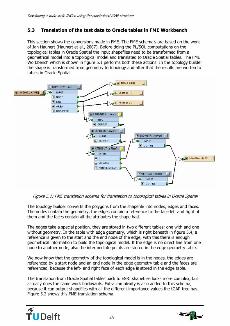
Developing a vario-scale IMGeo using the constrained tGAP structure
48
5.3 Translation of the test data to Oracle tables in FME Workbench
This section shows the conversions made in FME. The FME schema’s are based on the work of Jan Haunert (Haunert et al., 2007). Before doing the PL/SQL computations on the topological tables in Oracle Spatial the input shapefiles need to be transformed from a geometrical model into a topological model and translated to Oracle Spatial tables. The FME Workbench which is shown in figure 5.1 performs both these actions. In the topology builder the shape is transformed from geometry to topology and after that the results are written to tables in Oracle Spatial.
Figure 5.1: FME translation schema for translation to topological tables in Oracle Spatial
The topology builder converts the polygons from the shapefile into nodes, edges and faces. The nodes contain the geometry, the edges contain a reference to the face left and right of them and the faces contain all the attributes the shape had. The edges take a special position, they are stored in two different tables; one with and one without geometry. In the table with edge geometry, which is right beneath in figure 5.4, a reference is given to the start and the end node of the edge, with this there is enough geometrical information to build the topological model. If the edge is no direct line from one node to another node, also the intermediate points are stored in the edge geometry table. We now know that the geometry of the topological model is in the nodes, the edges are referenced by a start node and an end node in the edge geometry table and the faces are referenced, because the left- and right face of each edge is stored in the edge table. The translation from Oracle Spatial tables back to ESRI shapefiles looks more complex, but actually does the same work backwards. Extra complexity is also added to this schema, because it can output shapefiles with all the different importance values the tGAP-tree has. Figure 5.2 shows this FME translation schema.

5. Generalisation: design and implementaion
49
Figure 5.2: FM
E translation schem
a for the translation of Oracle tables to shapefiles

Developing a vario-scale IMGeo using the constrained tGAP structure
50
5.4 The simple overlay method
The simple overlay method takes the end products of chapter 4 as starting point. The merged IMGeo and the merged Top10NL files are intersected in ArcGIS, this is a polygon intersection. All IMGeo objects are split in case of an intersection with a Top10NL object boundary. The split IMGeo objects are then assigned to the corresponding Top10NL region. This method gives a very smooth zoom from IMGeo objects to Top10NL objects, but it doesn’t keep the geometry of the IMGeo objects. Due to the intersection operation some IMGeo objects might be split in separated sections, because several parts of objects might be assigned to the same Top10NL region. Figure 5.3 shows an example of this phenomenon. To solve this problem, these objects are separated with the ArcGIS ‘Multipart to Singlepart‘, which creates new records for all separated objects. In total 817 new records had to be produced by this operation.
Figure 5.3: Two parts of the same road object in IMGeo belonging to the same Top10NL
object; in the table they are one record.
With the resulting shapefile the translation in FME to Oracle tables is done. In SQL Developer the tGAP procedures were executed; once with and once without weights. Step by step features were merged; the situation after the last step gives a good indication of what happened with the objects during the generalisation and whether this is a desirable result. In total 7702 merges were executed before coming to the end result. Figure 5.4 gives the Top10NL as it should be. This can be compared to figure 5.5 shows the end result of the constrained tGAP generalisation without weights (or all weights equal to 1) and figure 5.6 shows the end result with the weights of table 5.1.

5. Generalisation: design and implementaion
51
Figure 5.4: Visualisation of Top10NL
Figure 5.5: Visualisation of the end result using the simple overlay method without weights.

Developing a vario-scale IMGeo using the constrained tGAP structure
52
Figure 5.6: Visualisation of the end result using the simple overlay method with weights.
Comparing figures 5.5 and 5.6 to figure 5.4 the amount of road objects is directly striking. The explanation for this is the fact that far more area in IMGeo is classified as road as in Top10NL; this is stated in section 4.4 and Appendix E. Also considering the weights in figure 5.6 doesn’t give satisfying results. Figures 5.5 and 5.6 are only the end results of the tGAP generalisation. An overview of all intermediate results of all methods is provided in Appendix H. This shows how the build up of the end result took place. The result of this method is not satisfying, because it admits the Top10NL geometry too much. The geometry of the final result is the same as the geometry of Top10NL, because all IMGeo objects are split at the borders of a Top10NL object. The purpose is to come to a vario-scale IMGeo in which Top10NL plays a smaller role, therefore other methods are investigated.
5.5 The maximum area method
The maximum area method requires a lot of pre-processing before converting the data to Oracle tables. The reason for the creation of this method is that the geometry of the IMGeo data is far more accurate than the geometry of Top10NL. Therefore the geometry of the IMGeo objects will be kept in this method. The constrained tGAP structure only merges objects and currently doesn’t generalise lines. However, this is being developed and will be mentioned in the future work of this thesis. For this reason the results of this method will not be optimal, because the level of detail of the lines is too high for the representation at scale 1:10,000.

5. Generalisation: design and implementaion
53
The approach to come to an input dataset for the tGAP structure using the maximum area method has the following steps:
• Joining the IMGeo objects with Top10NL in ArcGIS • Selecting the maximum overlapping Top10NL object to be the region of the IMGeo
object These steps are treated in separate subsections.
5.5.1 Joining the IMGeo objects with Top10NL in ArcGIS
The joining of IMGeo objects with Top10NL is done with the ArcGIS operator Spatial Join. Figure 5.7 shows what options were used in this join operation. The join operation is a one-to-many operation, because we want to see all the possible connections between the IMGeo objects and Top10NL objects in the resulting shapefile. The result of this action is a table in which an IMGeo object is mentioned with all its overlapping Top10NL objects. The difference between this table and the intersection in section 5.4 is that in this table the objects are kept as a whole, not as parts. We need this because we finally want to append a whole object to the input dataset for the constrained tGAP. This table is called ‘IMGeoSpatialJoin’ in the next section. The table with the intersections from section 5.4 is called ‘AppendTop10ID’.
5.5.2 Selecting the right region using the maximum area method.
After all IMGeo objects are assigned to the geometrical right Top10NL objects, the IMGeo objects are to be assigned to just one region, to one single Top10NL-ID. The IMGeo data is first selected with respect to its GML_ID, which is the unique identifier of the IMGeo objects. The selected features all have a Top10ID. If an IMGeo object appears to have more than one Top10ID, there has to be made a choice between these Top10ID’s. The method to be used here is the maximum area method. The full code is inserted in Appendix F. The area of the objects belonging to a certain IMGeo-object (with its GML_ID) is collected in a set. After the last value has been collected, the maximum of this set is computed. With this value the correct set of GML-ID and Top10ID can be selected and finally be appended to a new file called IMGeoTop10NLFinal1, which is the first input for the constrained tGAP structure. The method is shown in algorithm 5.1. The inputs for this method are the IMGeoSpatialJoin table from subsection 5.5.1 and the AppendTop10ID table from subsection 5.4. The resulting table is called ‘MaximumAreaDataset’. For every object i from IMGeo_Merge:
Select from AppendTop10ID where GML_ID = i For every selected object: Select the area of the object in ‘set’ Max(set) Append object from IMGeoSpatialJoin to MaximumAreaDataset with area=max(Set) and GML_ID = i
Algorithm 5.1: Iteration of the maximum area method
After applying this method a plot has been made of the test area, in which the IMGeo-objects are coloured according to their region class, which gives an indication of what region

Developing a vario-scale IMGeo using the constrained tGAP structure
54
Figure 5.7: The Spatial Join operation in ArcGIS
object they are assigned to. For this maximum area code this gives the result shown in figure 5.8. Comparing figure 5.8 to figure 5.9, which is again the original Top10NL data, some expected and some unexpected effects can be seen. A large part of the road areas between houses are now classified as terrain objects as region class. We also see that some residence objects at the corners of housings blocks are now classified as terrain objects in their assigned region. This is not according to what we want, but it is a consequence of the geometrical differences between the models described in chapter 4. The last unexpected failure we see in the right corner beneath where a large terrain part is now classified as residence object. This is also what we didn’t expect to happen. After these processes we end up with all IMGeo objects assigned to one region. The geometry of the IMGeo objects will not change during the merging inside the tGAP. This is something that needs attention in the tGAP structure, but which is currently subject of research at the group GISt as TU Delft.
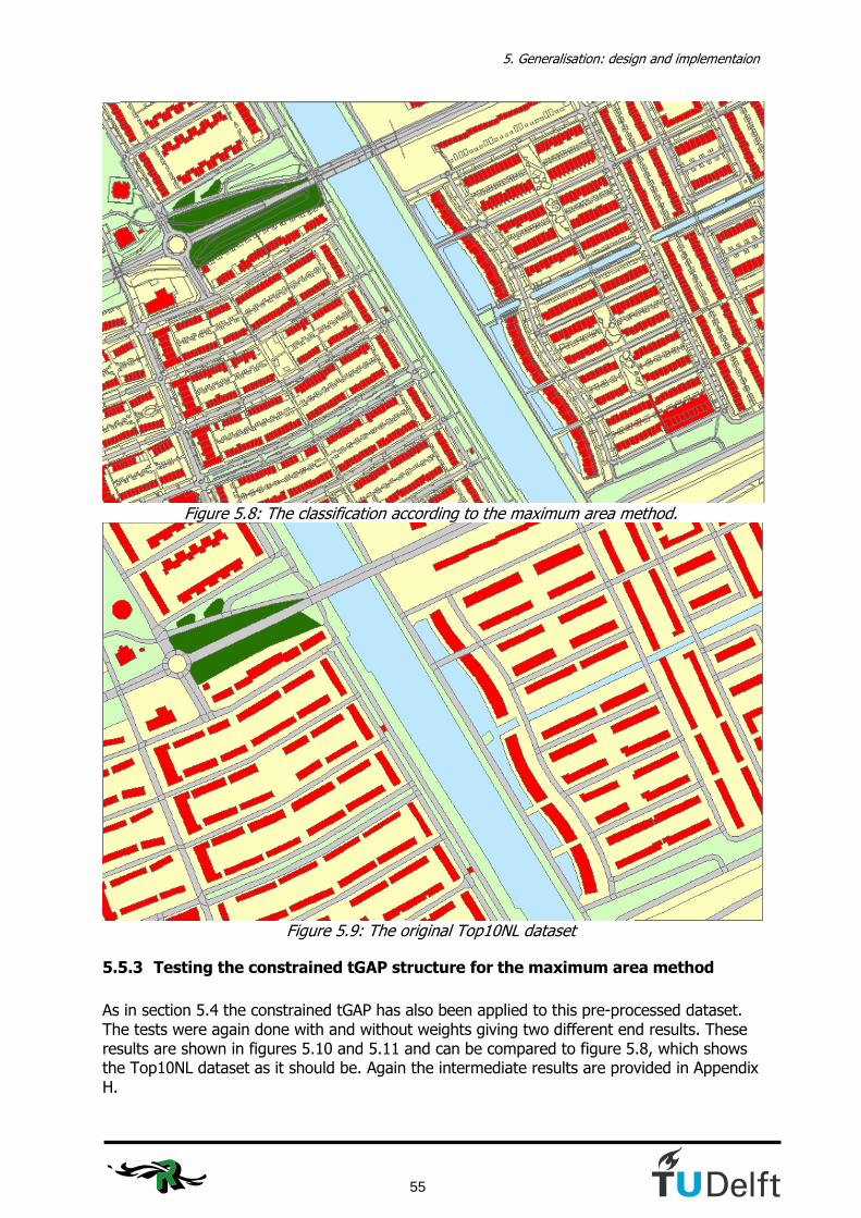
5. Generalisation: design and implementaion
55
Figure 5.8: The classification according to the maximum area method.
Figure 5.9: The original Top10NL dataset
5.5.3 Testing the constrained tGAP structure for the maximum area method
As in section 5.4 the constrained tGAP has also been applied to this pre-processed dataset. The tests were again done with and without weights giving two different end results. These results are shown in figures 5.10 and 5.11 and can be compared to figure 5.8, which shows the Top10NL dataset as it should be. Again the intermediate results are provided in Appendix H.
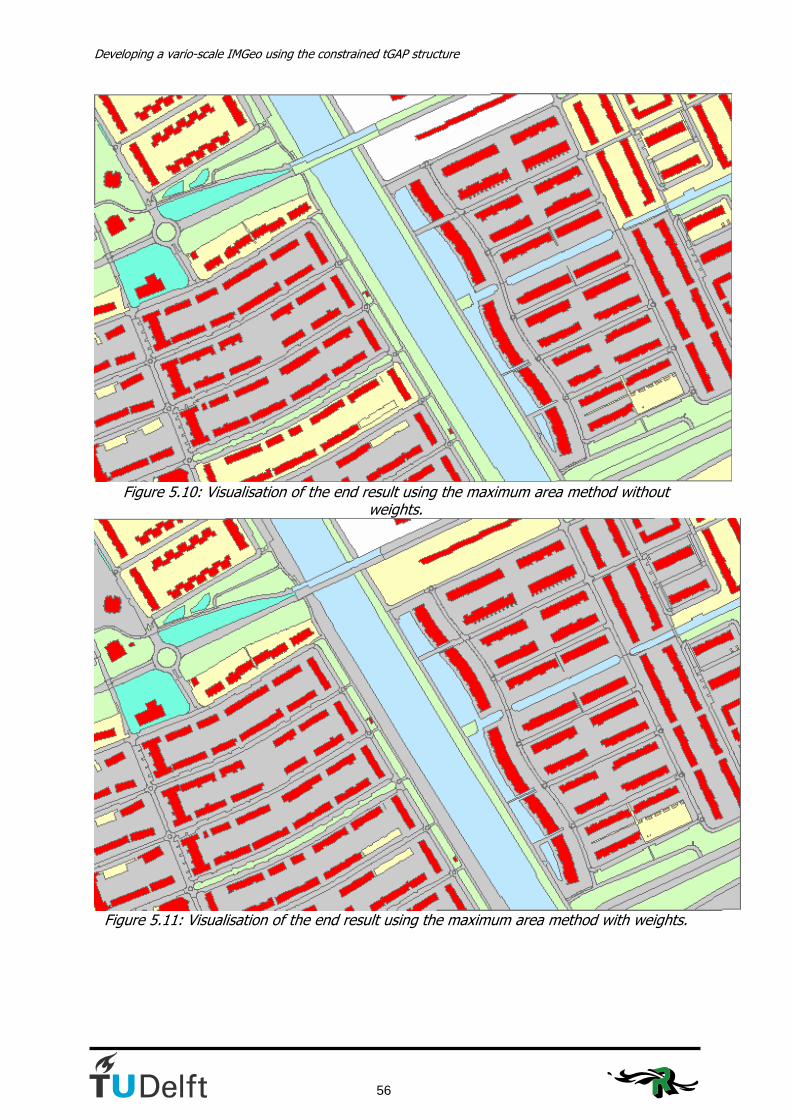
Developing a vario-scale IMGeo using the constrained tGAP structure
56
Figure 5.10: Visualisation of the end result using the maximum area method without
weights.
Figure 5.11: Visualisation of the end result using the maximum area method with weights.

5. Generalisation: design and implementaion
57
5.6 The 35%-split method
In the 35%-split method the IMGeo objects are split if there is more than one Top10NL object overlapping for more than 35% with the IMGeo objects relative to the IMGeo object size. The reason this method is developed is mainly because the classification of buildings needs to be improved. The corner buildings in the MaximumAreaDataset were too often classified as terrain. The number of Top10NL objects that overlap for more than 35% with an IMGeo object differs per IMGeo object. It can either be 2, 1 or 0. In case of two Top10NL objects satisfying the 35% rule the IMGeo object is split. This is done as a pre process before running the code of the maximum area method. With this code only those IMGeo objects are selected that have two Top10ID’s satisfying this rule. One of these IMGeo objects is written to a separate shapefile. For the remaining objects the maximum area method again is applied. The tables IMGeoSpatialJoin and AppendTop10ID are again used in this method; the only part that differs is the code of subsection 5.5.2. Algorithm 5.2 can be seen as a pre-process to the maximum area method. The total number of objects that is split according to this 35%-split method is 236 (out of 4159 IMGeo objects). Algorithm 5.2 shows how the code works. The resulting dataset is called ‘35%SplitDataset’. As with the previous codes, the full code is provided in Appendix F. For every object i from IMGeo_Merge:
Select from AppendTop10ID where GML_ID = i For every selected object: If (Shape area / Area of the original IMGeo object) > 0,35: Add to ‘set’ If ‘set’ contains 2 objects: Append one of the objects to 35%SplitDataset
Assign a new unique GML_ID to the other object
Algorithm 5.2: Iteration of the 35%-split method
The visualisation of the resulting final dataset following from this code can be compared to the Top10NL dataset as it should be. The Top10NL dataset is shown in figure 5.13. The result of the 35% split method is shown in figure 5.12 with the IMGeo objects classified according to their region class.

Developing a vario-scale IMGeo using the constrained tGAP structure
58
Figure 5.12: The classification according to the 35%-split method.
Figure 5.13: The original Top10NL dataset
Results for the constrained tGAP using the 35%-split method Figures 5.14and 5.15 show the end results of the constrained tGAP generalisation using the 35%-split method. The code is processed with and without weights and all intermediate results are provided in Appendix H. The result can also be compared to the Top10NL dataset in figure 5.13.

5. Generalisation: design and implementaion
59
Figure 5.14: Visualisation of the end result using the 35%-split method without weights.
Figure 5.15: Visualisation of the end result using the 35%-split method with weights.
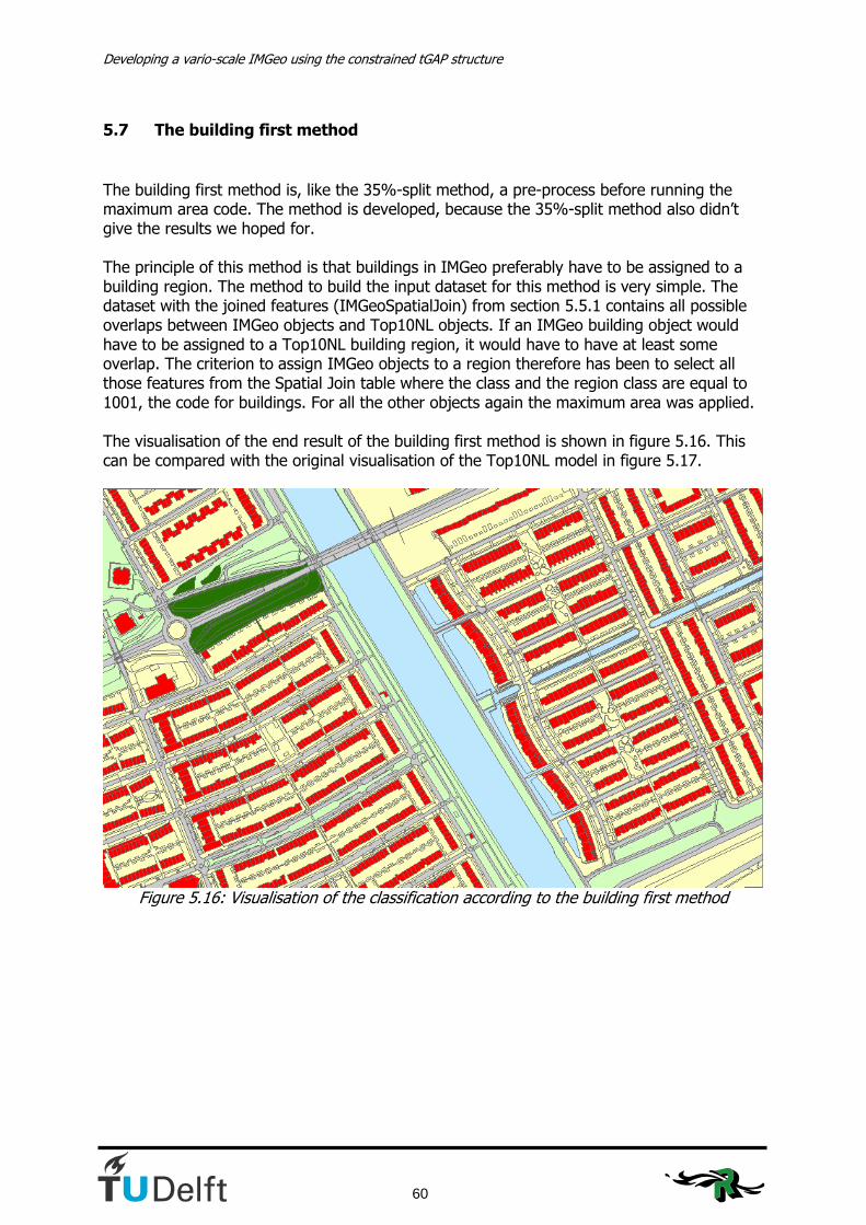
Developing a vario-scale IMGeo using the constrained tGAP structure
60
5.7 The building first method
The building first method is, like the 35%-split method, a pre-process before running the maximum area code. The method is developed, because the 35%-split method also didn’t give the results we hoped for. The principle of this method is that buildings in IMGeo preferably have to be assigned to a building region. The method to build the input dataset for this method is very simple. The dataset with the joined features (IMGeoSpatialJoin) from section 5.5.1 contains all possible overlaps between IMGeo objects and Top10NL objects. If an IMGeo building object would have to be assigned to a Top10NL building region, it would have to have at least some overlap. The criterion to assign IMGeo objects to a region therefore has been to select all those features from the Spatial Join table where the class and the region class are equal to 1001, the code for buildings. For all the other objects again the maximum area was applied. The visualisation of the end result of the building first method is shown in figure 5.16. This can be compared with the original visualisation of the Top10NL model in figure 5.17.
Figure 5.16: Visualisation of the classification according to the building first method

5. Generalisation: design and implementaion
61
Figure 5.17: The original Top10NL dataset
Results for the constrained tGAP using the building first method Figures 5.18 and 5.19 show the end results of the constrained tGAP generalisation using the building first method. The code is processed with and without weights and all intermediate results are provided in Appendix H. The result can also be compared to the Top10NL dataset in figure 5.17.
Figure 5.18: Visualisation of the end result using the building first method without weights.
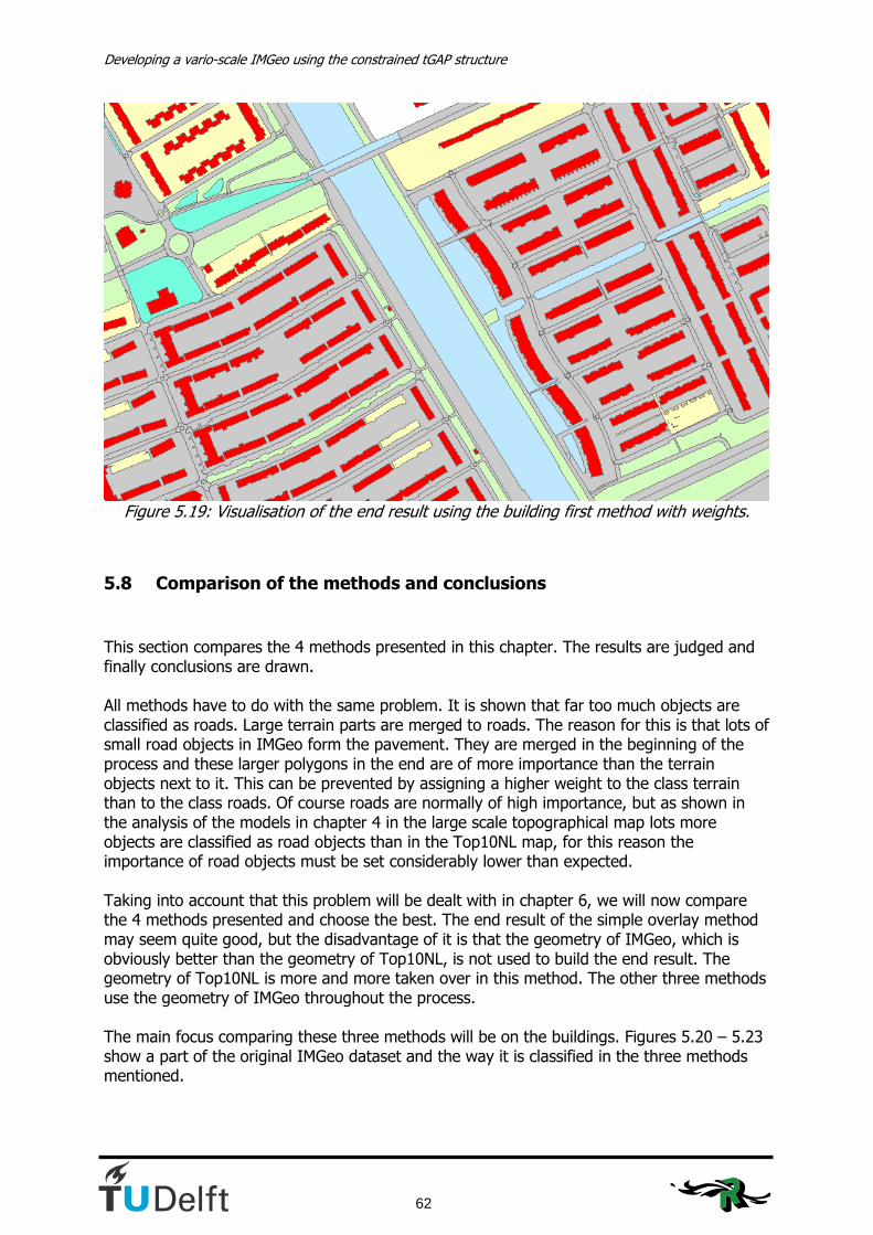
Developing a vario-scale IMGeo using the constrained tGAP structure
62
Figure 5.19: Visualisation of the end result using the building first method with weights.
5.8 Comparison of the methods and conclusions
This section compares the 4 methods presented in this chapter. The results are judged and finally conclusions are drawn. All methods have to do with the same problem. It is shown that far too much objects are classified as roads. Large terrain parts are merged to roads. The reason for this is that lots of small road objects in IMGeo form the pavement. They are merged in the beginning of the process and these larger polygons in the end are of more importance than the terrain objects next to it. This can be prevented by assigning a higher weight to the class terrain than to the class roads. Of course roads are normally of high importance, but as shown in the analysis of the models in chapter 4 in the large scale topographical map lots more objects are classified as road objects than in the Top10NL map, for this reason the importance of road objects must be set considerably lower than expected. Taking into account that this problem will be dealt with in chapter 6, we will now compare the 4 methods presented and choose the best. The end result of the simple overlay method may seem quite good, but the disadvantage of it is that the geometry of IMGeo, which is obviously better than the geometry of Top10NL, is not used to build the end result. The geometry of Top10NL is more and more taken over in this method. The other three methods use the geometry of IMGeo throughout the process. The main focus comparing these three methods will be on the buildings. Figures 5.20 – 5.23 show a part of the original IMGeo dataset and the way it is classified in the three methods mentioned.

5. Generalisation: design and implementaion
63
Figure 5.20: Part of the original IMGeo dataset
Figure 5.21: Part of the IMGeo dataset according to the maximum area method
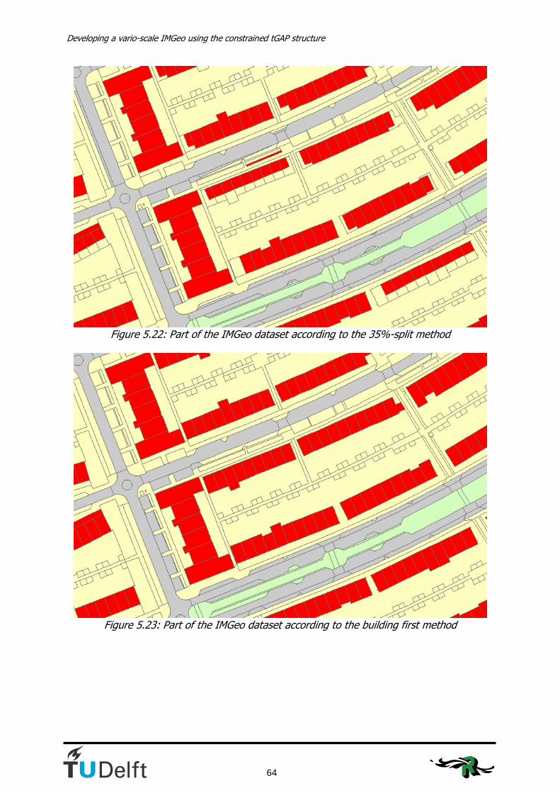
Developing a vario-scale IMGeo using the constrained tGAP structure
64
Figure 5.22: Part of the IMGeo dataset according to the 35%-split method
Figure 5.23: Part of the IMGeo dataset according to the building first method

5. Generalisation: design and implementaion
65
The differences between the classifications of the buildings in figures 5.20 – 5.23 are remarkable. In figure 5.21 we see some buildings classified as terrain because the building in Top10NL is placed in such a way that the maximum overlap the IMGeo building has is with the terrain. In figure 5.22 we see also an unwanted effect. The buildings become very small due to the split action. Because these results weren’t satisfying the building first method was developed. The result in figure 5.23 shows that all buildings are classified as buildings, the result we expected. The necessity to split objects in the case that more than one Top10NL object overlaps the IMGeo object for 35 % (or any other percentage) or more wasn’t proven. Only 236 out of 4159 objects needed to be split; this is only 5,6% of the total amount of objects. The splitting of buildings according to the 35%-split rule is not what we wanted and it appeared that most of the other split objects involved buildings (143). Also some roads were split (68); the cause of this is that the splitting of road objects is done differently in both models. This is something that needs attention and will be discussed in chapter 6. The buildings first method will be the method on which further tests will be done. Taking this method as point of departure is also good with respect to the project GBKN buildings in Top10NL, which was described in section 2.7.3. If the GBKN buildings are to be placed in Top10NL it is good to take them all as a whole to our next research phase in which especially the roads will need special attention. The improvements are described in chapter 6.

Developing a vario-scale IMGeo using the constrained tGAP structure
66

6. Improvements for the constrained tGAP structure
67
6. Improvements for the constrained tGAP structure Now the building first method has been chosen in chapter 5 as the best method to continue the research with, we continue with improvements for the results of chapter 5. First, section 6.1 describes the modifications that have been done to the weights and compatibilities to get to a proper end result. In section 6.2 the tGAP procedures are executed without the constraint and finally in section 6.3 the methods of this chapter are applied on the whole dataset of Almere.
6.1 Improvements of the weights and compatibilities
The improvement of the weights- and compatibility values is mainly based on ‘trial and error’. Tables 6.1 and 6.2 show the comparison between the weights table used in chapter 5 and the weights table used by (Van Putten and Van Oosterom, 2000). Because the research by Van Putten also focussed on a polygon GBKN the weights used by her can be seen as best practice.
Class Weight
Terrain (TRN) 5 Road (WEG) 80 Water (WTR) 10 Crossing (KNP) 2 Building (GBW) 400 Railroad (SBN) 20
Table 6.1: Class weights used by Van Putten (2000).
Class Code Weight
Residence object / Building 1001 0,9 Other Building 5003 0,4 Road 2001 0,6 Water 3001 0,5 Lot 4001 0,3 Fallow land 4002 0,1 Plants 4003 0,3 Terrain (to be determined) 4004 0,1 Grass / Grassland 4005 0,3 Bin 5001 0,1
Table 6.2: Initial class weights for this research.
A remarkable fact is that Van Putten used other classes; the classes railroad and crossing are not realised in this IMGeo test dataset. The IMGeo dataset contains some topographical elements (Bin and Other Building) and has the objects of the class ‘terrain’ subdivided into 5 subtypes of terrain. The weights Van Putten assigns to the objects differ from the weights used in chapter 5 as well. As we set Van Putten’s work as best practice and we know that the weights used in chapter 5 need to be changed, we first need to know what can be learned of the weights of Van Putten.

Developing a vario-scale IMGeo using the constrained tGAP structure
68
The value Van Putten puts for buildings is very high compared to the other objects, this seems to be a good suggestion, because in our output also some building blocks were generalised to terrain, which is unwanted. The second most important object Van Putten mentions is road. This will not work for our dataset, since we have far more road objects in the IMGeo model (due to side walks) than we have in the Top10NL model which causes a classification problem in the end. The weight for terrain is set very low in Van Putten’s method, but the value for e.g. ‘Lot’ needs to be higher than road to compensate the number of road objects. Tables 6.3 and 6.4 show the respectively the compatibility matrix of Van Putten and the compatibility matrix used in chapter 5.
TRN WEG WTR KNP GBW SBN TRN 0,1 0,2 0, 0,5 0,9 0,5
WEG 0,1 1 0,005 0,9 0,005 0,005 WTR 0,4 0,1 1 0,1 0,1 0,1 KNP 0,1 0,9 0,005 1 0,005 0,8
GBW 0,7 0,2 0,005 0,005 1 0,005 SBN 0,1 0,005 0,005 0,8 0,005 1
Table 6.3: Compatibility values used by Van Putten (2000).
Class 1→ 1001 5003 2001 3001 4001 4002 4003 4004 4005 5001 Class 2 ↓ Cost
1001 0 1 50 100 1 10 50 50 100 100 5003 1 0 50 100 50 10 50 50 100 100 2001 50 50 0 100 50 50 5 10 50 5 3001 100 100 100 0 100 100 100 100 100 100 4001 10 5 5 100 0 10 10 10 20 10 4002 10 5 10 100 5 0 10 10 50 20 4003 50 50 50 100 20 50 0 5 10 10 4004 10 5 50 100 20 10 100 0 50 20 4005 50 50 10 100 20 50 5 5 0 5 5001 100 100 100 100 100 100 100 100 100 0
Table 6.4: Initial compatibility values for this research
The way Van Putten defines compatibility is different from the one used in this research. Van Putten uses the length of the common boundary together with the compatibility value to determine the most compatible neighbour; the maximum value is taken. In this research we use the area of the neighbour and the transition cost to determine this most compatible neighbour; we take the neighbour that costs least for transition. For this reason the compatibility values are actually ‘class incompatibilities’. This method was proposed in the work of Haunert (Haunert et al., 2007) and is adopted in this research without further consideration. What can be learned from the method of Van Putten is the fact that it shouldn’t be that objects of the same sort should be automatically merged. If all small road objects in a terrain region would be merged, a road object will be created with such area that the whole terrain area will be classified as road in the end. This is exactly what happened in chapter 5 when all the terrain objects were in the end classified as road objects. Results With this information a ‘trial and error’ process was started up. The steps taken in this phase are visualised in Appendix I. With ever changing values for the weights and compatibilities a

6. Improvements for the constrained tGAP structure
69
proper end result was reached in the end. The final result of the last trial in this process is visualised in figure 6.1. This can be compared to the original Top10NL dataset, which is provided in figure 6.2 and the original IMGeo dataset, provided in figure 6.3. The final weight- and compatibility values for this test dataset in Almere are presented in tables 6.5 and 6.6.
Class Code Weight
Residence object / Building 1001 13 Other Building 5003 1 Road 2001 1,2 Water 3001 1,3 Lot 4001 9 Fallow land 4002 1 Plants 4003 0,9 Terrain (to be determined) 4004 0,1 Grass / Grassland 4005 1 Bin 5001 0,1
Table 6.5: Final weights for the IMGeo test dataset.
Class 1→ 1001 5003 2001 3001 4001 4002 4003 4004 4005 5001 Class 2 ↓ Cost
1001 0 1 50 100 1 10 50 50 100 100 5003 1 0 50 100 50 10 50 50 100 100 2001 50 50 1 100 50 50 5 10 100 5 3001 100 100 100 0 100 100 100 100 20 100 4001 50 5 5 100 0 10 10 10 20 10 4002 10 5 10 100 5 0 10 10 50 20 4003 50 50 50 100 20 50 1 5 1 10 4004 10 5 50 100 20 10 100 0 50 20 4005 50 50 5 10 20 50 1 5 1 5 5001 100 100 100 100 100 100 100 100 100 0
Table 6.6: Final compatibility values for the IMGeo test dataset.
Figure 6.1: Final result of weights and compatibility improvements

Developing a vario-scale IMGeo using the constrained tGAP structure
70
Figure 6.2: The original Top10NL dataset
Figure 6.3: The original IMGeo dataset

6. Improvements for the constrained tGAP structure
71
The end result following from the constrained tGAP generalisation is not exactly like the Top10NL dataset, there is a number of causes for this, which will be discussed:
• The geometry of IMGeo was maintained during generalisation • The classification in both models differs • The class of the final object is not forced to become the region class • Large road objects cause strange phenomena
The reason why the geometry of IMGeo was maintained during generalisation has been described before. We trust the geometrical accuracy of IMGeo more than Top10NL. Moreover, the tGAP algorithms executed for this dataset will be extended with line simplification algorithms in the near future, probably giving better end results. The second and the third cause are related to each other. The classification of some objects in the IMGeo dataset can never be the same as the objects in the Top10NL dataset, because they don’t exist in that dataset. For example, there are no wood objects in the IMGeo test dataset, whereas some plant- and grass objects are classified as wood in the Top10NL dataset. The object hierarchy could be that plants and grass have to be generalised in the end to wood, but this is not the case, because also in Top10NL grass objects appear. The only way to solve this problem is to force the object to take over the region class as class in the end of the tGAP process. To do this some proposals can be done, which were not executed during this research. First, in the last merge of every region a check can be executed which checks whether the class of the neighbour absorbing the object is equal to the region class, if not, then change it to the region class. Second, the region class can be a weighing factor in determining what the most compatible neighbour of an object is by for example inserting such a weighing factor in the compatibility matrix. This would make the compatibility matrix a 3D matrix, because the value will then depend on the class of the least important face, the class of the neighbour and the region class. This of course has the advantage of a smooth transition towards the end, but has as disadvantage that the class of the end object will never become the region class if there is no such object in the region. For this the forcing will be needed. An important issue is the large road objects that appear in both datasets, especially in the IMGeo dataset. Due to the fact that every IMGeo object is assigned to just one region, some strange end results can be generated in which an object has a strange shape. The main explanation for this is then that a former large road object in IMGeo caused this strange boundary of the object. In figure 6.4 and 6.5 a comparison is made of the end result and the original IMGeo file showing that a smarter cutting of road objects leads to better results.

Developing a vario-scale IMGeo using the constrained tGAP structure
72
Figure 6.4: A strange looking grass object in the end result
Figure 6.5: The road object causing the strange shape in figure 6.4
The example shown in figures 6.4 and 6.5 shows that it would be wise for a generalisation structure to cut the road objects at all crossings. The second example shows that road objects are too large compared to other objects to be able to make a fair generalisation structure based on the least important area. Figure 6.6 shows small grass objects which are generalised to a road object creating such a large road object that in the end also the larger and more important grass object is absorbed in it. The road object which is made up along the canal originates from the very narrow (bicycle) road next to the canal. This object obviously needed to be generalised to a grass object, but it didn’t, because the road object was not neatly cut into several pieces.

6. Improvements for the constrained tGAP structure
73
Figure 6.6: The end result (left) showing a large and unexpected road object along the canal
and the original IMGeo dataset (right).
6.2 tGAP without constraint
After having determined the right weights for the constrained tGAP we also would like to see how the objects react on the case where there is no constraint. This means that objects can also be merged with objects outside their own region. If this gives good results, this is a sign that the constraint might not even be necessary. Without constraints the whole test dataset is in the end generalised to only one object. This appeared to be a road object. In appendix J the whole generalisation process to come to an end result is shown. At this place we only show the result after 3805 merging operations, which is exactly the amount of merges also done in the test dataset. Figure 6.7 shows the result.

Developing a vario-scale IMGeo using the constrained tGAP structure
74
Figure 6.7: Normal tGAP after 3805 merges
In figure 6.7 it is shown that there are some differences between the results of the normal tGAP and the constrained tGAP. The remarkable cases are mainly roads, buildings and water. As stated in chapter 4 the total area of road objects in IMGeo is far larger than in Top10NL. This is mainly caused by pavements, which are not taken into account by the Top10NL for cartographic reasons. Because of the constraint and the large terrain objects the extension of the roads in IMGeo are in the end merged to terrain objects, whereas in the normal tGAP the roads can expand freely. Especially in the north-west corner of the test dataset this gives unwanted results. Buildings are of course of very much importance. They are most of the time closed in by terrain objects. In figure 6.7 it is shown that also the building objects are taking more space than they should have. Especially in the south-west corner of figure 6.7 some examples are shown. The only two water objects in figure 6.7 form the large canal, whereas in the original Top10NL dataset also some smaller water objects exist east of the canal. In figure 6.7 these water objects are absorbed by other objects, because the constraint was the element that preserved the water objects from being merged. The weights used in this test are the weights from table 6.5 and therefore not optimalised for the normal tGAP. It is assumed that the optimalised weights for the constrained tGAP should also hold for the normal tGAP. To guide the generalisation of datasets like this we can conclude from this test that the constraint is really a useful concept which can improve the quality of the results from the tGAP structure.
6. Improvements for the constrained tGAP structure
75
6.3 Testing the constrained tGAP on a larger dataset
The methods used until now have been tested on just a fraction of the data. In this section the results are shown of the test of the methods developed for the whole test area indicated in figure 4.2. To give an impression of the larger test area figure 6.8 is inserted, showing the Top10NL representation of the area. The Top10NL is shown here instead of the IMGeo, because the scale of the map wouldn’t be appropriate for the IMGeo representation. The black rectangle indicates the smaller test area used before. Of course the number of objects in this test dataset is a lot higher. There are over 27,000 IMGeo objects and over 3500 Top10NL objects in this test area. But the main difference between the previous test data and this larger dataset is the fact that some objects appear in this larger dataset that didn’t appear before. The new objects in the IMGeo dataset are (between brackets their code):
• Wood (4006) • Arable land (4010) • Separation (5002) • Unknown (6001)
The new objects in the Top10NL dataset are:
• Built area (4009) • Arable land (4010) • Unknown (6001)
At least one of these new object types is remarkable. The object class ‘unknown’ is inserted, because the intsersection method of section 5.4 didn’t assign a Top10ID to all IMGeo objects properly. The disadvantage of this ‘Union-operator’ was that not all objects received an ID, because they seemed to ArcGIS not to be belonging to any object in the other model. The fact that these objects were really small and that only a very small part of the objects didn’t receive an ID (< 0,1 %) led to the conclusion that this operator could be used. The objects that didn’t receive an ID and class in the first place were given an ID manually and they got the class 6001, which means unknown.
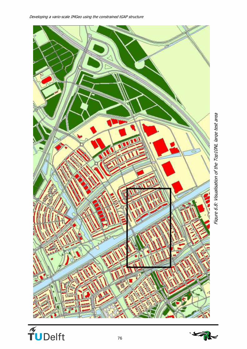
Developing a vario-scale IMGeo using the constrained tGAP structure
76
Figure 6.8: Visualisation of the Top10NL large test area

6. Improvements for the constrained tGAP structure
77
The weights table and compatibility matrix have been extended for the new object classes. The values for the classes that already were determined are the same as in table 6.5 and 6.6. The new tables are shown in tables 6.7 and 6.8.
Class Code Weight Residence object / Building 1001 13 Road 2001 1,2 Water 3001 1,3 Lot 4001 9 Fallow land 4002 1 Plants 4003 0,9 Terrain (to be determined) 4004 0,1 Grass / Grassland 4005 1 Wood 4006 1 Arable land 4010 0,5 Bin 5001 0,1 Separation 5002 0,1 Other Building 5003 1 Unknown 6001 0,0000000001
Table 6.7: Class weights for the large test dataset
Class 1→ 1001 2001 3001 4001 4002 4003 4004 4005 4006 4010 5001 5002 5003 6001 Class 2 ↓ Cost
1001 0 50 100 1 10 50 50 100 100 100 100 100 1 1 2001 50 1 100 50 50 5 10 100 100 50 5 5 50 1 3001 100 100 0 100 100 100 100 20 100 100 100 100 100 1 4001 50 5 100 0 10 10 10 20 100 50 10 10 5 1 4002 10 10 100 5 0 10 10 50 100 20 20 20 5 1 4003 50 50 100 20 50 1 5 1 10 50 10 10 50 1 4004 10 50 100 20 10 100 0 50 100 50 20 20 5 1 4005 50 5 10 20 50 1 5 1 10 20 5 5 50 1 4006 50 50 100 50 50 1 10 10 0 50 20 20 50 1 4010 50 100 100 20 20 50 10 20 10 0 50 50 50 1 5001 100 100 100 100 100 100 100 100 100 100 0 5 100 1 5002 100 100 100 20 100 100 100 100 100 100 5 0 100 1 5003 1 50 100 50 10 50 50 100 100 100 100 100 0 1 6001 100 100 100 100 100 100 100 100 100 100 100 100 100 1
Table 6.8: Compatibility matrix for the large test dataset
Figure 6.9 shows the end result of the constrained tGAP for this large dataset. Appendix K also shows the intermediate results. In spite of the iteration for the previous test dataset road objects remain a problem when combining both datasets. For this reason some iterationsteps were also applied for this larger test dataset to come to an optimal result. The result of this is shown in figure 6.10. The weights that were changed to come to this result are provided in table 6.9.

Developing a vario-scale IMGeo using the constrained tGAP structure
78
Figure 6.9: End result of the constrained tGAP tree with weights of table 6.7.

6. Improvements for the constrained tGAP structure
79
Figure 6.10: End result of the constrained tGAP tree with weights of table 6.9

Developing a vario-scale IMGeo using the constrained tGAP structure
80
Class Code Weight
Residence object / Building 1001 17 Road 2001 1,05 Water 3001 1,5 Lot 4001 14 Fallow land 4002 1 Plants 4003 0,8 Terrain (to be determined) 4004 0,1 Grass / Grassland 4005 0,9 Wood 4006 1 Arable land 4010 0,5 Bin 5001 0,1 Separation 5002 0,1 Other Building 5003 0,3 Unknown 6001 0,0000000001
Table 6.9: Changed weights for the iterated end result of figure 6.10 The values currently used give almost the same results for our previous test area. During the trials the values for ‘building’ and ‘lot’ were continuously decreased to get to a weight as proportional as possible to the other object. It appeared these values needed some adjustment upwards. The results in figure 6.10 now are very satisfying. There is one remarkable fact that arises in figure 6.10 and that is the point of the difference in actuality between both maps. Looking at figure 6.10 we see a large building object in the south-most part of the map. Comparing this to figure 6.8 we see that there is no building at this place in Top10NL. Because of this the building on this fallow land couldn’t be classified in the building region and therefore now takes the whole object around it as well.
6.4 Conclusions
The adjustment of weights and compatibility values gives a good and balanced end result for the constrained tGAP structure for the test area used in this research. It is well worth researching whether there can be found a connection between the distribution of overlapping areas between two datasets and the weights for the constrained tGAP structure to be derived from that. If this is the case no iteration will be needed anymore. For this research more test datasets need to be inspected. The road objects caused most problems in this test dataset. It is therefore wise for the administrators of road objects to cut these objects into well defined smaller pieces to be able to control them, not only for generalisation purposes. Lots of municipalities in The Netherlands are currently working on the conversion from a line GBKN to a polygon GBKN and this is one of the issues they have to solve. The constraint in the constrained tGAP structure appeared to be quite necessary. If we apply the tGAP without constraint we see immediately the enormous expansion of road objects whereas we want them to be canalised and reduced in the end result. This canalisation is hard to create with compatibility values, but also worth more research.

7. Conclusions, recommendations and future research
81
7. Conclusions, recommendations and future research The aim of this report has been to answer the following question: How can a vario-scale IMGeo be designed and developed by applying the constrained tGAP structure with Top10NL as initial constraint? This chapter will first answer this question based on the findings of the master thesis in section 7.1. After this recommendations will be given in 7.2 and suggestions for future research will be done in section 7.3.
7.1 Conclusions
The municipality of Rotterdam wanted to find a way to be able to generate vario-scale maps out of one data source through this research. From the beginning it has been stated that this research is far ahead of the current situation in Rotterdam. During this research it showed that Rotterdam is really working to cooperate with other municipal services to get to a situation where large scale topographical data is really produced at one place and used by all other parties within the municipality. Whether this dataset will be used in the future as a source for the medium- and small scale map, was the main question of this research. The conclusion can be drawn that the intention to get there certainly is present. Gemeentewerken Rotterdam has been one of the parties that initiated IMGeo. For now IMGeo is defined as a large scale topographical model, but the vision is to have a vario-scale topographical model in the future. The research issues in section 1.3 addressed questions about the organisation of the municipality of Rotterdam and the way a generalisation structure would fit in this. The organisation was studied in chapter 2 and it can be concluded that generating the medium scale base map from the large scale topographical base map is still some steps ahead of the current processes within the municipality of Rotterdam. IMGeo and Top10NL are the datasets that have been investigated during this research. Both are based on NEN3610, but both models are developed independently. If the developers of IMGeo should have looked closer at the definitions of Top10NL, differences in details between the models could have been avoided. Since these differences do exist, this is something more care could have been taken of. Combining both datasets in this research it has been found that the differences between the models are geometrical as well as semantical. The geometrical differences are there because the collection rules differ and because the accuracy in the IMGeo model is higher than in Top10NL. Also a small amount of the geometrical differences can be attributed to generalisation operations like displacement. These geometrical differences lead to the fact that a lot of pre-processing needs to be done to really make a good connection between the models. The semantical differences in the models, or the errors in the classification, lead to the conclusion that no hierarchy between the object classes in both models can be created. The test data of both models showed also that a lot of pre-processing is necessary to enable it as a source for the constrained tGAP. Both models need to be an area partition. IMGeo is supposed to be an area partition at relative height level 0; however, the test data,

Developing a vario-scale IMGeo using the constrained tGAP structure
82
originating from a pilot with IMGeo in Almere, was not an area partition. This wasn’t implemented yet in the conversion. Top10NL is not yet an area partition. By doing geo-processing operations in ArcGIS it was possible to make both models an area partition, but those operations can’t be done backwards. For this reason it will never be possible to extract a Top10NL file according to the current product specifications using the constrained tGAP tree. If the Kadaster would change the product specification to an area partition, the possibility to produce Top10NL using the constrained tGAP structure would increase. Although the conclusion might be drawn that current Top10NL data can’t be extracted from IMGeo data, the conclusion can be drawn that IMGeo and Top10NL are very well combinable. The fact that most of the objects in both datasets are polygons makes them suitable for a combination in the tGAP structure with IMGeo objects as the basis and Top10NL objects as the regions. From the four methods that have been investigated to assign an IMGeo object to a Top10NL-region in the pre-processing phase the ‘building first’-method is the best. This method assigns all IMGeo buildings to a building region even if they only overlap a little. All the other objects are processed according to the ‘maximum area’-method; the Top10NL object overlapping most with the IMGeo object is the region to which the IMGeo object is assigned to. Repeated trial of class weight- and compatibility values gave the right values for the weights and the compatibility matrix. These values appeared to be about correct for the larger dataset as well, which was tested with the same method and values, only small adjustments were needed. A conclusion that can be drawn here is that the position of road objects in the generalisation process is very crucial; a better division of road objects into smaller pieces would absolutely lead to better generalisation results. The final conclusion is that the constrained tGAP certainly offers possibilities to extract medium scale topography from large scale topography, but that this method will probably have a long way towards an implementation in a commercial product. Whether the tGAP can be used in Rotterdam will therefore depend on when the municipality of Rotterdam wants to realize their vision to maintain topographical data only at the largest scale and how fast the progress of the tGAP towards a commercial product will be; both the organisation of Gemeentewerken Rotterdam and the TU Delft with its tGAP structure have a long term vision.
7.2 Recommendations
The recommendations are treated in two blocks. First of all recommendations to the municipality of Rotterdam and other municipalities are given, after this recommendations to the Kadaster about cooperation and the specifications of Top10NL are given. Recommendations for future research is treated separately. Rotterdam A recommendation can be made to municipalities that want to convert their GBKN to IMGeo data. The pilot data of Almere was in some cases not according to the standard. If a municipality chooses to turn to this standard, all things have to fit. If for example the data at relative height level 0 is not an area partition, it is still hard to use as input for the tGAP structure. The conversion of data can also lead to inconsistencies in the dataset. In the pilot data of Almere doubled objects with unique ID’s showed up. These errors don’t need to be

7. Conclusions, recommendations and future research
83
the consequence of conversions, the errors can also have been in the source data, but it is something to take into account when doing the conversion. To road objects should be paid extra attention in the future, especially in IMGeo. To keep objects controlable, not only with respect to generalisation, they need to be cut into smaller pieces, most likely at junctions (Uitermark et al., 1999). Municipalities that are currently making a polygon GBKN, such as IMGeo, should be especially aware of this problem. The overall recommendation to the municipality of Rotterdam is that the tGAP structure offers possibilities for the extraction of vario-scale data out of large scale topographical data, but it is not the only way. By the time the municipality wants to implement this, the tGAP must not be seen as the only way to generalise. Walking in front of this Gemeentewerken Rotterdam could look for partners in their search for ways to solve this issue. Within the projects DURP Ondergronden and MobiMaps parties like ESRI are also interested in generalising large scale topographical data. TU Delft and ITC are always interested in renewing initiatives. Rotterdam could play the role of the perfect playground for researching parties to test their methods on, assumed that Rotterdam stays a renewing municipality in the field of geo-information. Kadaster The cooperation between IMGeo and Top10NL will hopefully improve. Both models are created apart from each other and are not related to each other, besides through NEN3610. To come to an automatic generalisation structure in which the constraint plays a role it is necessary to get to a class hierarchy, which only can be made if Top10NL is derived from IMGeo or if IMGeo is the detailed version of Top10NL. To come to a situation in which medium scale topographical data and further scales can be derived from large scale topographical data, there must be agreement on what should be the content of the derived scales. The project IMTop is a good example of a process to come to content derived from generalised data. The recommendation can be made to include also large scale topographical data in this research. The product specification of Top10NL is currently that it is not an area partition. This has led to a lot of pre-processing in this thesis work. Since the real world actually is an area partition, the recommendation can be made to the Kadaster to consider to change the specification of Top10NL in order to make it an area partition. During this research continuously the translation between a polygon structure and a topological structure had to be made. A recommendation to both IMGeo and Top10NL is to consider the use of a topological structure for the data model instead of a polygon structure. A topological structure will save storage space and avoid topological errors in models.

Developing a vario-scale IMGeo using the constrained tGAP structure
84
7.3 Future research
The concept of a constrained tGAP hasn’t been totally developed after this research. In the summer of 2007 it was only a concept developed by the universities of Delft and Hannover. There is plenty of room for improvement and further research after this research. In this research the pre-processing of the data is done with polygons; this gave problems, also due to the fact that a standard deviation is used in these polygon computation in ArcGIS. In a topological structure there is no room for these standard deviations; it is more strict. Probably other problems will arise when going to a topological structure, but this is something to be researched. A topographical model with a topological structure also requires antoher way of thinking; Delft University of Technology can play a large role in creating support for this idea for instance in convincing GeoNovum of the necessity of a topological structure. To improve the final results of this master thesis a line generalisation algorithm is really necessary. The presentation of the final results is not optimal, because of the lack of line simplification. This is currently subject of research at the group GISt at Delft University of Technology. During this research the region class of a constraint object hasn’t been taken into account. It is recommended to do this in the future to prevent errors with e.g. road objects filling up large areas. The region class can be a weighing factor in determining the most compatible neighbour, making the compatibility matrix a 3D matrix; if this is not enough to get the desired end result (e.g. because of semantical mismatches), the region class can also be forced in the last merging step of the region. A possible drawback of the tGAP structure is the fact that it has to be an area partition. With a reality which is more and more expanding in the third dimension the need for a 3D solution for the tGAP will also be larger and larger. Most topographical registrations nowadays at least have an attribute ‘relative heigth’, which enables us to put more than 1 object at the same place. This can’t be done in the tGAP right now, because of the strict rule of the area partition. More research will be needed here to come to a solution. Another drawback of the tGAP is the fact that importance values can’t be translated to a scale. With the constrained tGAP this can possibly change. The scale of the end result is known and the scale of the starting point is known. By looking at the size of the merged objects scales in between possibly can be derived. The weights in the constrained tGAP can possibly be determined by studying the amount of overlap between the models. This can’t be determined on the basis of only one test dataset. To determine whether this relation exists studying more datasets is needed.
85
References
Anders, K.-H., Bobrich, J., MRDB approach for automatic incremental update. ICA Workshop
on Generalisation and Multiple Representation, Leicester 2004, 2004. Basic model Geo-information (in Dutch), NEN 3610, Nederlands Normalisatie Instituut, 2005. Bakker, N., Bruns, B., Storm, M., Data model Top10NL (in Dutch), version 2.3, February 2005, (Topografische Dienst) Kadaster and International Institute For Geo-Information and Earth Observation (ITC), 2005. Bobrich, J., Cartographic Map Generalisation in Urban Districts. In Proceedings of GIS Research UK, 9th Annual Conference, pp. 513-515, 2001. Boelhouwer, M., The future of small-scale topography in Rotterdam (in Dutch), Gemeentewerken Rotterdam, project code SAE30306, 2006. Campschroer, J., Krijgsman, W., Weerd, L. van der, Architectuur van het stelsel; deel I:Het wezen van het stelsel (in Dutch), november 2006, versie 1.3, Stroomlijning Basisgegevens, 2006. CHANGE Kurzdokumentation. Hannover: Institut für Kartographie und Geoinformatik, (on-line). Universität Hannover, 2003. Damen, J., Building block generalisation (to be published), Master Thesis, Utrecht University, 2008. Downey, A., How to think like a (Python) programmer, Green Tea Press, Needham, Massachusets, 2007. Galanda, M., Automated Polygon Generalization in a Multi Agent System. PhD thesis, University of Zürich, 2003. Google Earth, earth.google.com, 2008. Product informaton GBKN (in Dutch), www.gbkn.nl, LSV GBKN (on-line), 2006. Hampe, M., Anders, K.-H., Sester, M., MRDB applications for data revision and real-time generalisation. In: Proceedings of the 21st International Cartographic Conference. Durban, 10.–16. August 2003, pp.192–201, 2003. Hampe, M., Sester, M., Harrie, L., Multiple representation databases to support visualisation on mobile devices. In: Proceedings of the 20th ISPRS Congress, July12-23, 2004, Istanbul, Turkey: International Archives of Photogrammetry, Remote Sensing and Spatial Information Sciences, pp. 135-140, 2004. Haunert, J.-H., Efficient area aggregation by combination of different techniques. In: Proc. of 10th ICA Workshop on Generalisation and Multiple Representation, 2–3 August 2007, Moscow, Russia, 2007.
Developing a vario-scale IMGeo using the constrained tGAP structure
86
Haunert, J. H., Dilo, A., Oosterom, P. van, Using the constrained tGAP for progressive vector data transfer, 2007. Hidding, J., Uitermark, H.T., GBKN-buildings in Top10NL (in Dutch), In: Geo-Info 2006-1, pp.20-22, 2006. Hofman, A. M., Application of generalisation in Rotterdam; a literature study. TU Delft, www.gdmc.nl, 2007. ICA, Multilingual Dictionary of Technical Terms in Cartography. Franz Steiner Verlag, Wiesbaden, 1973. ISO, ISO 19109:2005 Geographic Information - Rules for Application Schema. International Organisation for Standardization, 2005. IMGeo version 1.0 (in Dutch), 2007. Kresse, W., Fadaie, K., ISO Standards for Geographic Information. Springer, Heidelberg, New York, Tokyo, 2004. Landelijk Samenwerkingsverband GBKN, GBKN towards an authentic registration? (in Dutch), Documentnr. 02.05/053, 2002. Landelijk Samenwerkingsverband GBKN, GBKN specificaties in NEN 1878; LSV-specificaties, versie 1.1 (in Dutch), Documentnr. 04.05/070, 2004. Lentjes, P., Structure of Top10NL (in Dutch), Powerpoint presentation by Alterra, Wageningen UR, April 3rd 2007, 2007. Mc Master, R.B., Shea, K.S., Generalization in digital cartography, Association of American Geographers, 1992. Meijers, M., Implementation and testing of variable scale topological data structures, Master Thesis TU Delft, 2006. Müller, J., Lagrange, J., and Weibel, R., GIS and Generalization: Methodology and Practice. Number 1 in GISDATA. Taylor & Francis, 1995. Neuffer, D., Hopewell, T., Woodsford, P., Integration of Agent-based Generalisation with Mainstream Technologies and other System Components, ICA Workshop on Generalisation and Multiple Representation, Leicester 2004, 2004. Ormeling, F.J., Kraak, M.J., Cartography: Visualisation of Spatial Data (in Dutch), Delft: Delftse Universitaire Pers, 1993. Oosterom, P.J.M. van, The GAP-tree, an approach to “on-the-fly” map generalisation of an area partitioning, In: volume GIS and Generalization: Methodology and Practice of GISDATA, chapter 9, pages 120–132. Taylor & Francis, London, 1993. Oosterom, P.J.M. van, Variable-scale topological data structures suitable for progressive data transfer: the GAP-face tree and GAP-edge forest, In: Cartography and geographic information science, 32, pp. 331-346, 2005.
87
Oosterom, P.J.M. van, Vries M. de, Meijers, M., Vario-scale data server in a web service context, In: Proceedings of the ICA Commission Workshop on Map Generalisation and Multiple Representation, June 25th 2006, 14 p., 2006. Putten, J.D. van, Oosterom, P.J.M. van, Generaliseren van vlakkenpartities (1); GAP-trees, theorie en implementatie (in Dutch), In: Geodesia, Volume 42, 10, pp. 443-448, 2000. Putten, J.D. van, Oosterom, P.J.M. van, Generaliseren van vlakkenpartities (2); GAP-trees, testresultaten en verbeteringen (in Dutch), In: Geodesia, Volume 42, 11, pp. 499-505, 2000. Rietdijk, M., Verhoef, J.J., Address unknown (in Dutch), Uitgever Programma Stroomlijning Basisgegevens, Den Haag, 2002. Schravendeel, D., Steen, K. van der, Rij, K. van, Rietdijk, M., Heemskerk-van Holtz, P., Studyreport on Systematic deepening (in Dutch), Ministerie van VROM, documentnr. 050228 Stelselrapport versie 03 (concept), 2005. Sester, M., Optimization approaches for generalization and data abstraction. International Journal of Geographical Information Science 19(8-9), pp. 871-897, 2005. Spaccapietra, S., Vangenot, C., Parent, C., Zimányi, E., MurMur: A Research Agenda on Multiple Representations. In: International Symposium on Database Applications in Non-Traditional Environments, DANTE 1999. 28-30 November 1999, Kyoto, Japan. IEEE Computer Society 1999, ISBN 0-7695-0496-5, pp. 373-384, 1999. Stoter, J., Quak, W., Van Oosterom, P.J.M., Meijers, M., Lemmens, R., Uitermark, H., Considerations for the design of a semantic data model for a multi-representation topographical database. In: Proceedings, ISGI 2007, International Symposium on Generalisation of Information, 2007. Stoter, J., Lemmens, R., Köbben, B., Preliminary investigation TopNL (in Dutch), International Institute for Geo-information Science and Earth Observation (ITC), 2007. Uitermark, H., Vogels, A., Oosterom, P. van, Semantic and Geometric Aspects of Integrating Road Networks. In proceedings of the 2nd International conference on Interoperating Geographic Information Systems, 10-12 March'99, Zurich, LNCS 1580, Springer-Verlag, pages 177-188, 1999. Ware, M.J., Jones, C.B., Thomas, N., Automated map generalization with multiple operators: a simulated annealing approach. International Journal of Geographical Information Science, vol 17(no. 8): pages 743-769. December 2003, 2003.

Developing a vario-scale IMGeo using the constrained tGAP structure
88

89
List of appendices Appendix A: UML class model IMGeo Appendix B: UML class model Top10NL Appendix C: Type of geometry of spatial attributes in IMGeo Appendix D: Type of geometry of spatial attributes in Top10NL Appendix E: Statistics of the overlay from IMGeo and Top10NL (test area) Appendix F: Python scripts Appendix G: tGAP code in PL/SQL Appendix H: Visualised results of the constrained tGAP Appendix I: Visualisation of the trials to improve the values for weights and compatibilities Appendix J: Visualisation of the tGAP without constraint Appendix K: Visualisation of the constrained tGAP methods for the large dataset
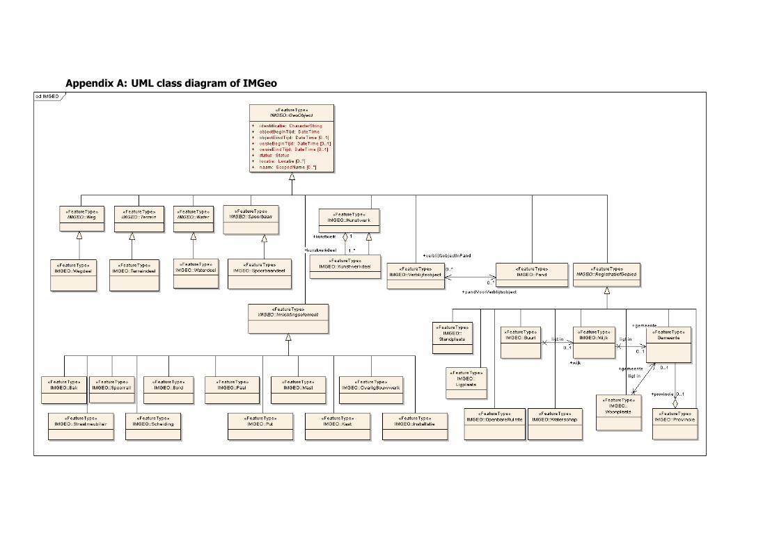
Appendix A: UML class diagram of IMGeo

Appendix B: UML class diagram of Top10NL

92
Appendix C: Type of geometry of spatial attributes in IMGeo
Objectklasse Attribuut Attribuutwaarde punt lijn vlak
geo-object identificatie < identificerende waarde >
geo-object objectBeginTijd < systeemtijd >
geo-object objectEindTijd < systeemtijd >
geo-object versieBeginTijd < systeemtijd >
geo-object versieEindTijd < systeemtijd >
geo-object status plan
geo-object status bestaand
geo-object status historie
geo-object locatie Aanduiding van locatie door adresgegevens
geo-object naam Benaming van het geo-object
wegdeel type infrastructuur verbinding x
wegdeel type infrastructuur kruising x
wegdeel type infrastructuur vlakte x
wegdeel type weg OV-baan x
wegdeel type weg overweg x
wegdeel type weg pad x
wegdeel type weg parkeervlak x
wegdeel type weg perron (voor tramverkeer)
x
wegdeel type weg rijbaan x
wegdeel type weg rijwielpad x
wegdeel type weg vluchtheuvel x
wegdeel type weg voetgangersgebied x
wegdeel type weg voetpad x
wegdeel type weg wegberm x
wegdeel type weg woonerf x
wegdeel type weg onbekend (IMGeo:nader te bepalen)
x
wegdeel verhardingstype gesloten verharding x
wegdeel verhardingstype open verharding x
wegdeel verhardingstype onverhard x
wegdeel hoogteniveau < getal > x
spoorbaandeel type infrastructuur verbinding x
spoorbaandeel type infrastructuur kruising x
spoorbaandeel type infrastructuur vlakte x
spoorbaandeel type spoorbaan trein x
spoorbaandeel type spoorbaan tram x
spoorbaandeel type spoorbaan metro x
spoorbaandeel type spoorbaan (haven)kraan x
spoorbaandeel type spoorbaan sneltram, lightrail x
spoorbaandeel type spoorbaan onbekend (IMGeo:nader te bepalen)
x
spoorbaandeel hoogteniveau < getal > x
waterdeel type infrastructuur verbinding x
waterdeel type infrastructuur kruising x
waterdeel type infrastructuur vlakte x
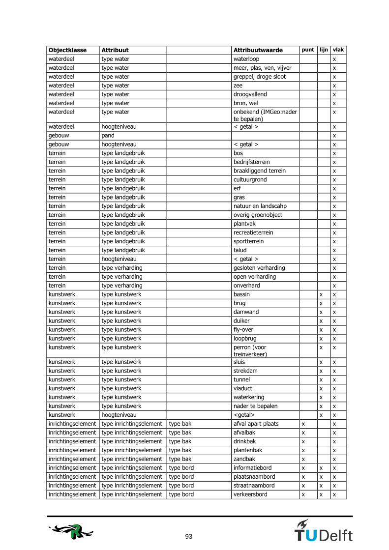
93
Objectklasse Attribuut Attribuutwaarde punt lijn vlak
waterdeel type water waterloop x
waterdeel type water meer, plas, ven, vijver x
waterdeel type water greppel, droge sloot x
waterdeel type water zee x
waterdeel type water droogvallend x
waterdeel type water bron, wel x
waterdeel type water onbekend (IMGeo:nader te bepalen)
x
waterdeel hoogteniveau < getal > x
gebouw pand x
gebouw hoogteniveau < getal > x
terrein type landgebruik bos x
terrein type landgebruik bedrijfsterrein x
terrein type landgebruik braakliggend terrein x
terrein type landgebruik cultuurgrond x
terrein type landgebruik erf x
terrein type landgebruik gras x
terrein type landgebruik natuur en landscahp x
terrein type landgebruik overig groenobject x
terrein type landgebruik plantvak x
terrein type landgebruik recreatieterrein x
terrein type landgebruik sportterrein x
terrein type landgebruik talud x
terrein hoogteniveau < getal > x
terrein type verharding gesloten verharding x
terrein type verharding open verharding x
terrein type verharding onverhard x
kunstwerk type kunstwerk bassin x x
kunstwerk type kunstwerk brug x x
kunstwerk type kunstwerk damwand x x
kunstwerk type kunstwerk duiker x x
kunstwerk type kunstwerk fly-over x x
kunstwerk type kunstwerk loopbrug x x
kunstwerk type kunstwerk perron (voor treinverkeer)
x x
kunstwerk type kunstwerk sluis x x
kunstwerk type kunstwerk strekdam x x
kunstwerk type kunstwerk tunnel x x
kunstwerk type kunstwerk viaduct x x
kunstwerk type kunstwerk waterkering x x
kunstwerk type kunstwerk nader te bepalen x x
kunstwerk hoogteniveau <getal> x x
inrichtingselement type inrichtingselement type bak afval apart plaats x x
inrichtingselement type inrichtingselement type bak afvalbak x x
inrichtingselement type inrichtingselement type bak drinkbak x x
inrichtingselement type inrichtingselement type bak plantenbak x x
inrichtingselement type inrichtingselement type bak zandbak x x
inrichtingselement type inrichtingselement type bord informatiebord x x x
inrichtingselement type inrichtingselement type bord plaatsnaambord x x x
inrichtingselement type inrichtingselement type bord straatnaambord x x x
inrichtingselement type inrichtingselement type bord verkeersbord x x x
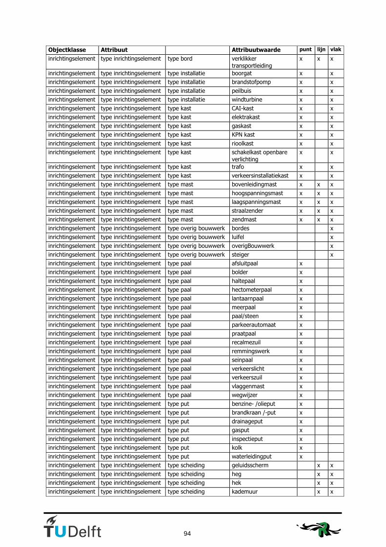
94
Objectklasse Attribuut Attribuutwaarde punt lijn vlak
inrichtingselement type inrichtingselement type bord verklikker transportleiding
x x x
inrichtingselement type inrichtingselement type installatie boorgat x x
inrichtingselement type inrichtingselement type installatie brandstofpomp x x
inrichtingselement type inrichtingselement type installatie peilbuis x x
inrichtingselement type inrichtingselement type installatie windturbine x x
inrichtingselement type inrichtingselement type kast CAI-kast x x
inrichtingselement type inrichtingselement type kast elektrakast x x
inrichtingselement type inrichtingselement type kast gaskast x x
inrichtingselement type inrichtingselement type kast KPN kast x x
inrichtingselement type inrichtingselement type kast rioolkast x x
inrichtingselement type inrichtingselement type kast schakelkast openbare verlichting
x x
inrichtingselement type inrichtingselement type kast trafo x x
inrichtingselement type inrichtingselement type kast verkeersinstallatiekast x x
inrichtingselement type inrichtingselement type mast bovenleidingmast x x x
inrichtingselement type inrichtingselement type mast hoogspanningsmast x x x
inrichtingselement type inrichtingselement type mast laagspanningsmast x x x
inrichtingselement type inrichtingselement type mast straalzender x x x
inrichtingselement type inrichtingselement type mast zendmast x x x
inrichtingselement type inrichtingselement type overig bouwwerk bordes x
inrichtingselement type inrichtingselement type overig bouwwerk luifel x
inrichtingselement type inrichtingselement type overig bouwwerk overigBouwwerk x
inrichtingselement type inrichtingselement type overig bouwwerk steiger x
inrichtingselement type inrichtingselement type paal afsluitpaal x
inrichtingselement type inrichtingselement type paal bolder x
inrichtingselement type inrichtingselement type paal haltepaal x
inrichtingselement type inrichtingselement type paal hectometerpaal x
inrichtingselement type inrichtingselement type paal lantaarnpaal x
inrichtingselement type inrichtingselement type paal meerpaal x
inrichtingselement type inrichtingselement type paal paal/steen x
inrichtingselement type inrichtingselement type paal parkeerautomaat x
inrichtingselement type inrichtingselement type paal praatpaal x
inrichtingselement type inrichtingselement type paal recalmezuil x
inrichtingselement type inrichtingselement type paal remmingswerk x
inrichtingselement type inrichtingselement type paal seinpaal x
inrichtingselement type inrichtingselement type paal verkeerslicht x
inrichtingselement type inrichtingselement type paal verkeerszuil x
inrichtingselement type inrichtingselement type paal vlaggenmast x
inrichtingselement type inrichtingselement type paal wegwijzer x
inrichtingselement type inrichtingselement type put benzine- /olieput x
inrichtingselement type inrichtingselement type put brandkraan /-put x
inrichtingselement type inrichtingselement type put drainageput x
inrichtingselement type inrichtingselement type put gasput x
inrichtingselement type inrichtingselement type put inspectieput x
inrichtingselement type inrichtingselement type put kolk x
inrichtingselement type inrichtingselement type put waterleidingput x
inrichtingselement type inrichtingselement type scheiding geluidsscherm x x
inrichtingselement type inrichtingselement type scheiding heg x x
inrichtingselement type inrichtingselement type scheiding hek x x
inrichtingselement type inrichtingselement type scheiding kademuur x x
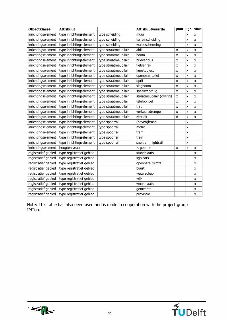
95
Objectklasse Attribuut Attribuutwaarde punt lijn vlak
inrichtingselement type inrichtingselement type scheiding muur x x
inrichtingselement type inrichtingselement type scheiding terreinscheiding x x
inrichtingselement type inrichtingselement type scheiding walbescherming x x
inrichtingselement type inrichtingselement type straatmeubilair abil x x x
inrichtingselement type inrichtingselement type straatmeubilair boom x x x
inrichtingselement type inrichtingselement type straatmeubilair brievenbus x x x
inrichtingselement type inrichtingselement type straatmeubilair fietsenrek x x x
inrichtingselement type inrichtingselement type straatmeubilair kunstobject x x x
inrichtingselement type inrichtingselement type straatmeubilair openbaar toilet x x x
inrichtingselement type inrichtingselement type straatmeubilair oprit x x x
inrichtingselement type inrichtingselement type straatmeubilair slagboom x x x
inrichtingselement type inrichtingselement type straatmeubilair speelwerktuig x x x
inrichtingselement type inrichtingselement type straatmeubilair straatmeubilair (overig) x x x
inrichtingselement type inrichtingselement type straatmeubilair telefooncel x x x
inrichtingselement type inrichtingselement type straatmeubilair trap x x x
inrichtingselement type inrichtingselement type straatmeubilair verkeersdrempel x x x
inrichtingselement type inrichtingselement type straatmeubilair zitbank x x x
inrichtingselement type inrichtingselement type spoorrail (haven)kraan x
inrichtingselement type inrichtingselement type spoorrail metro x
inrichtingselement type inrichtingselement type spoorrail tram x
inrichtingselement type inrichtingselement type spoorrail trein x
inrichtingselement type inrichtingselement type spoorrail sneltram, lightrail x
inrichtingselement hoogteniveau < getal > x x x
registratief gebied type registratief gebied standplaats x
registratief gebied type registratief gebied ligplaats x
registratief gebied type registratief gebied openbare ruimte x
registratief gebied type registratief gebied buurt x
registratief gebied type registratief gebied waterschap x
registratief gebied type registratief gebied wijk x
registratief gebied type registratief gebied woonplaats x
registratief gebied type registratief gebied gemeente x
registratief gebied type registratief gebied provincie x
Note: This table has also been used and is made in cooperation with the project group IMTop.

96
Appendix D: Type of geometry of sptial attributes in Top10NL
Objectklasse Attribuut Attribuutwaarde punt lijn vlak
wegdeel identificatie < identificerende waarde >
wegdeel objectBeginTijd < systeemtijd >
wegdeel objectEindTijd < systeemtijd >
wegdeel versieBeginTijd < systeemtijd >
wegdeel versieEindTijd < systeemtijd >
wegdeel brontype luchtfoto
wegdeel brontype kaart
wegdeel brontype RD
wegdeel brontype GBKN
wegdeel brontype top10vector
wegdeel brontype overig
wegdeel bronbeschrijving < tekst >
wegdeel bronactualiteit < datum >
wegdeel bronnauwkeurigheid < getal >
wegdeel dimensie 2D
wegdeel dimensie 3D
wegdeel type infrastructuur verbinding x x
wegdeel type infrastructuur kruising x x
wegdeel type infrastructuur overig verkeersgebied x
wegdeel type weg autosnelweg x x x
wegdeel type weg hoofdweg x x x
wegdeel type weg regionale weg x x x
wegdeel type weg lokale weg x x x
wegdeel type weg straat x x x
wegdeel type weg startbaan, landingsbaan x x x
wegdeel type weg rolbaan, platform x x x
wegdeel type weg overig x x x
wegdeel type weg onbekend x x x
wegdeel hoofdverkeersgebruik snelverkeer x x x
wegdeel hoofdverkeersgebruik gemengd verkeer x x x
wegdeel hoofdverkeersgebruik busverkeer x x x
wegdeel hoofdverkeersgebruik fietsers, bromfietsers x x x
wegdeel hoofdverkeersgebruik voetgangers x x x
wegdeel hoofdverkeersgebruik ruiters x x x
wegdeel hoofdverkeersgebruik vliegverkeer x x x
wegdeel hoofdverkeersgebruik parkeren x
wegdeel hoofdverkeersgebruik parkeren: carpoolplaats x
wegdeel hoofdverkeersgebruik parkeren: P+R parkeerplaats x
wegdeel hoofdverkeersgebruik overig x x x
wegdeel hoofdverkeersgebruik onbekend x x x
wegdeel fysiek voorkomen op vast deel van brug x x x
wegdeel fysiek voorkomen op beweegbaar deel van brug x x x
wegdeel fysiek voorkomen overkluisd x x x
wegdeel fysiek voorkomen in tunnel x x x
wegdeel fysiek voorkomen als veer/pont x
wegdeel verhardingsbreedteklasse > 7 meter x x x
wegdeel verhardingsbreedteklasse 4 - 7 meter x x x
wegdeel verhardingsbreedteklasse 2 -4 meter x x x
wegdeel verhardingsbreedteklasse < 2 meter x x
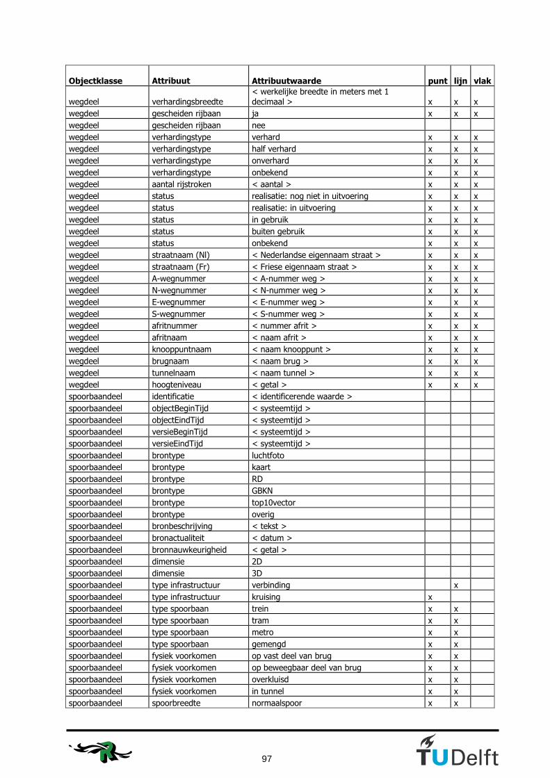
97
Objectklasse
Attribuut Attribuutwaarde punt lijn vlak
wegdeel verhardingsbreedte
< werkelijke breedte in meters met 1 decimaal >
x
x
x
wegdeel gescheiden rijbaan ja x x x
wegdeel gescheiden rijbaan nee
wegdeel verhardingstype verhard x x x
wegdeel verhardingstype half verhard x x x
wegdeel verhardingstype onverhard x x x
wegdeel verhardingstype onbekend x x x
wegdeel aantal rijstroken < aantal > x x x
wegdeel status realisatie: nog niet in uitvoering x x x
wegdeel status realisatie: in uitvoering x x x
wegdeel status in gebruik x x x
wegdeel status buiten gebruik x x x
wegdeel status onbekend x x x
wegdeel straatnaam (Nl) < Nederlandse eigennaam straat > x x x
wegdeel straatnaam (Fr) < Friese eigennaam straat > x x x
wegdeel A-wegnummer < A-nummer weg > x x x
wegdeel N-wegnummer < N-nummer weg > x x x
wegdeel E-wegnummer < E-nummer weg > x x x
wegdeel S-wegnummer < S-nummer weg > x x x
wegdeel afritnummer < nummer afrit > x x x
wegdeel afritnaam < naam afrit > x x x
wegdeel knooppuntnaam < naam knooppunt > x x x
wegdeel brugnaam < naam brug > x x x
wegdeel tunnelnaam < naam tunnel > x x x
wegdeel hoogteniveau < getal > x x x
spoorbaandeel identificatie < identificerende waarde >
spoorbaandeel objectBeginTijd < systeemtijd >
spoorbaandeel objectEindTijd < systeemtijd >
spoorbaandeel versieBeginTijd < systeemtijd >
spoorbaandeel versieEindTijd < systeemtijd >
spoorbaandeel brontype luchtfoto
spoorbaandeel brontype kaart
spoorbaandeel brontype RD
spoorbaandeel brontype GBKN
spoorbaandeel brontype top10vector
spoorbaandeel brontype overig
spoorbaandeel bronbeschrijving < tekst >
spoorbaandeel bronactualiteit < datum >
spoorbaandeel bronnauwkeurigheid < getal >
spoorbaandeel dimensie 2D
spoorbaandeel dimensie 3D
spoorbaandeel type infrastructuur verbinding x
spoorbaandeel type infrastructuur kruising x
spoorbaandeel type spoorbaan trein x x
spoorbaandeel type spoorbaan tram x x
spoorbaandeel type spoorbaan metro x x
spoorbaandeel type spoorbaan gemengd x x
spoorbaandeel fysiek voorkomen op vast deel van brug x x
spoorbaandeel fysiek voorkomen op beweegbaar deel van brug x x
spoorbaandeel fysiek voorkomen overkluisd x x
spoorbaandeel fysiek voorkomen in tunnel x x
spoorbaandeel spoorbreedte normaalspoor x x

98
Objectklasse Attribuut Attribuutwaarde punt lijn vlak
spoorbaandeel spoorbreedte smalspoor x x
spoorbaandeel spoorbreedte gemengd x x
spoorbaandeel aantal sporen < nummer > x x
spoorbaandeel vervoerfunctie gemengd gebruik x x
spoorbaandeel vervoerfunctie personenvervoer x x
spoorbaandeel vervoerfunctie goederenvervoer x x
spoorbaandeel vervoerfunctie museumlijn x x
spoorbaandeel elektrificatie geëlektrificeerd x x
spoorbaandeel elektrificatie niet geëlektrificeerd x x
spoorbaandeel elektrificatie gemengd x x
spoorbaandeel status realisatie: nog niet in uitvoering x x
spoorbaandeel status realisatie: in uitvoering x x
spoorbaandeel status in gebruik x x
spoorbaandeel status buiten gebruik x x
spoorbaandeel status onbekend x x
spoorbaandeel brugnaam < naam brug > x x
spoorbaandeel tunnelnaam < naam tunnel > x x
spoorbaandeel baanvaknaam < naam baanvak > x x
spoorbaandeel hoogteniveau < getal > x x
waterdeel identificatie < identificerende waarde >
waterdeel objectBeginTijd < systeemtijd >
waterdeel objectEindTijd < systeemtijd >
waterdeel versieBeginTijd < systeemtijd >
waterdeel versieEindTijd < systeemtijd >
waterdeel brontype luchtfoto
waterdeel brontype kaart
waterdeel brontype RD
waterdeel brontype GBKN
waterdeel brontype top10vector
waterdeel brontype overig
waterdeel bronbeschrijving < tekst >
waterdeel bronactualiteit < datum >
waterdeel bronnauwkeurigheid < getal >
waterdeel dimensie 2D
waterdeel dimensie 3D
waterdeel type infrastructuur verbinding x x
waterdeel type infrastructuur kruising x x
waterdeel type infrastructuur overig watergebied x x x
waterdeel type water waterloop x x
waterdeel type water meer, plas, ven, vijver x
waterdeel type water greppel, droge sloot x
waterdeel type water zee x
waterdeel type water droogvallend x
waterdeel type water bron, wel x
waterdeel type water onbekend x x x
waterdeel breedteklasse 0,5 - 3 meter x x
waterdeel breedteklasse 3 - 6 meter x x
waterdeel breedteklasse > 6 meter x
waterdeel breedte < werkelijke breedte in meters met 1 decimaal > x x
waterdeel hoofdafwatering ja x x x
waterdeel hoofdafwatering nee x x x
waterdeel fysiek voorkomen in sluis x x
waterdeel fysiek voorkomen op brug x x
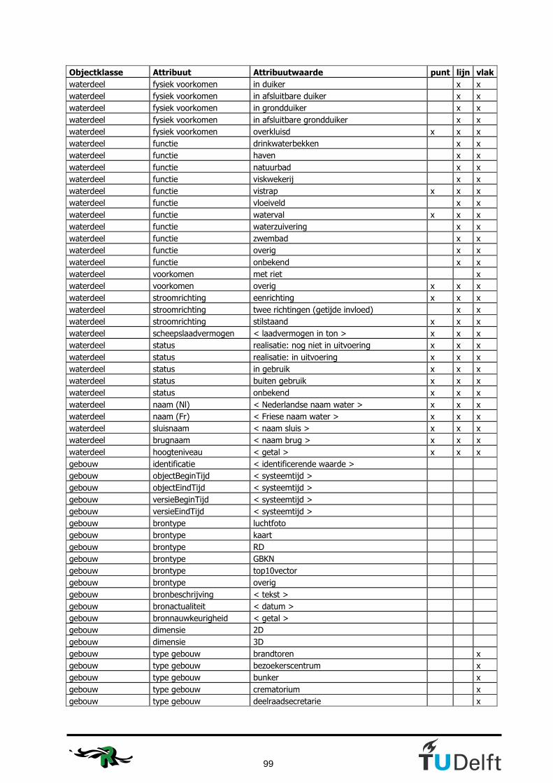
99
Objectklasse Attribuut Attribuutwaarde punt lijn vlak
waterdeel fysiek voorkomen in duiker x x
waterdeel fysiek voorkomen in afsluitbare duiker x x
waterdeel fysiek voorkomen in grondduiker x x
waterdeel fysiek voorkomen in afsluitbare grondduiker x x
waterdeel fysiek voorkomen overkluisd x x x
waterdeel functie drinkwaterbekken x x
waterdeel functie haven x x
waterdeel functie natuurbad x x
waterdeel functie viskwekerij x x
waterdeel functie vistrap x x x
waterdeel functie vloeiveld x x
waterdeel functie waterval x x x
waterdeel functie waterzuivering x x
waterdeel functie zwembad x x
waterdeel functie overig x x
waterdeel functie onbekend x x
waterdeel voorkomen met riet x
waterdeel voorkomen overig x x x
waterdeel stroomrichting eenrichting x x x
waterdeel stroomrichting twee richtingen (getijde invloed) x x
waterdeel stroomrichting stilstaand x x x
waterdeel scheepslaadvermogen < laadvermogen in ton > x x x
waterdeel status realisatie: nog niet in uitvoering x x x
waterdeel status realisatie: in uitvoering x x x
waterdeel status in gebruik x x x
waterdeel status buiten gebruik x x x
waterdeel status onbekend x x x
waterdeel naam (Nl) < Nederlandse naam water > x x x
waterdeel naam (Fr) < Friese naam water > x x x
waterdeel sluisnaam < naam sluis > x x x
waterdeel brugnaam < naam brug > x x x
waterdeel hoogteniveau < getal > x x x
gebouw identificatie < identificerende waarde >
gebouw objectBeginTijd < systeemtijd >
gebouw objectEindTijd < systeemtijd >
gebouw versieBeginTijd < systeemtijd >
gebouw versieEindTijd < systeemtijd >
gebouw brontype luchtfoto
gebouw brontype kaart
gebouw brontype RD
gebouw brontype GBKN
gebouw brontype top10vector
gebouw brontype overig
gebouw bronbeschrijving < tekst >
gebouw bronactualiteit < datum >
gebouw bronnauwkeurigheid < getal >
gebouw dimensie 2D
gebouw dimensie 3D
gebouw type gebouw brandtoren x
gebouw type gebouw bezoekerscentrum x
gebouw type gebouw bunker x
gebouw type gebouw crematorium x
gebouw type gebouw deelraadsecretarie x

100
Objectklasse Attribuut Attribuutwaarde punt lijn vlak
gebouw type gebouw dok x
gebouw type gebouw elektriciteitscentrale x
gebouw type gebouw fabriek x
gebouw type gebouw fort x
gebouw type gebouw gascompressiestation x
gebouw type gebouw gemaal x
gebouw type gebouw gemeentehuis x
gebouw type gebouw gevangenis x
gebouw type gebouw grenskantoor x
gebouw type gebouw hotel x
gebouw type gebouw huizenblok x
gebouw type gebouw hulpsecretarie x
gebouw type gebouw kapel x
gebouw type gebouw kas, warenhuis x
gebouw type gebouw kasteel x
gebouw type gebouw kerk x
gebouw type gebouw kerncentrale, kernreactor x
gebouw type gebouw kliniek, inrichting, sanatorium x
gebouw type gebouw klokkentoren x
gebouw type gebouw klooster, abdij x
gebouw type gebouw koeltoren x
gebouw type gebouw koepel x
gebouw type gebouw kunstijsbaan x
gebouw type gebouw lichttoren x
gebouw type gebouw luchtwachttoren x
gebouw type gebouw manege x
gebouw type gebouw metrostation x
gebouw type gebouw militair gebouw x
gebouw type gebouw motel x
gebouw type gebouw museum x
gebouw type gebouw parkeerdak, parkeerdek, parkeergarage x
gebouw type gebouw peilmeetstation x
gebouw type gebouw politiebureau x
gebouw type gebouw pompstation x
gebouw type gebouw postkantoor x
gebouw type gebouw psychiatrisch ziekenhuis, psychiatrisch centrum x
gebouw type gebouw radarpost x
gebouw type gebouw radartoren x
gebouw type gebouw radiotoren, televisietoren x
gebouw type gebouw recreatiecentrum x
gebouw type gebouw reddingboothuisje x
gebouw type gebouw reddinghuisje, schuilhut x
gebouw type gebouw religieus gebouw x
gebouw type gebouw remise x
gebouw type gebouw ruïne x
gebouw type gebouw schaapskooi x
gebouw type gebouw school x
gebouw type gebouw schoorsteen x
gebouw type gebouw sporthal x
gebouw type gebouw stadion x
gebouw type gebouw stadskantoor x
gebouw type gebouw tank x
gebouw type gebouw tankstation x

101
Objectklasse Attribuut Attribuutwaarde punt lijn vlak
gebouw type gebouw telecommunicatietoren x
gebouw type gebouw toren x
gebouw type gebouw transformatorstation x
gebouw type gebouw treinstation x
gebouw type gebouw uitzichttoren x
gebouw type gebouw universiteit x
gebouw type gebouw veiling x
gebouw type gebouw verkeerstoren x
gebouw type gebouw vuurtoren x
gebouw type gebouw waterradmolen x
gebouw type gebouw watertoren x
gebouw type gebouw wegenwachtstation x
gebouw type gebouw wegrestaurant x
gebouw type gebouw werf x
gebouw type gebouw windmolen x
gebouw type gebouw windmolen: korenmolen x
gebouw type gebouw windmolen: watermolen x
gebouw type gebouw windturbine x
gebouw type gebouw zendtoren x
gebouw type gebouw ziekenhuis x
gebouw type gebouw zwembad x
gebouw type gebouw overig x
gebouw hoogteklasse laagbouw x
gebouw hoogteklasse hoogbouw x
gebouw hoogteklasse onbekend x
gebouw hoogte < hoogte boven maaiveld in meters > x
gebouw status realisatie: nog niet in uitvoering x
gebouw status realisatie: in uitvoering x
gebouw status in gebruik x
gebouw status buiten gebruik x
gebouw status onbekend x
gebouw naam (Nl) < Nederlandse naam gebouw > x
gebouw naam (Fr) < Friese naam gebouw > x
gebouw hoogteniveau < getal > x
terrein identificatie < identificerende waarde >
terrein objectBeginTijd < systeemtijd >
terrein objectEindTijd < systeemtijd >
terrein versieBeginTijd < systeemtijd >
terrein versieEindTijd < systeemtijd >
terrein brontype luchtfoto
terrein brontype kaart
terrein brontype RD
terrein brontype GBKN
terrein brontype top10vector
terrein brontype overig
terrein bronbeschrijving < tekst >
terrein bronactualiteit < datum >
terrein bronnauwkeurigheid < getal >
terrein dimensie 2D
terrein dimensie 3D
terrein type landgebruik aanlegsteiger x
terrein type landgebruik akkerland x
terrein type landgebruik basaltblokken, steenglooiing x
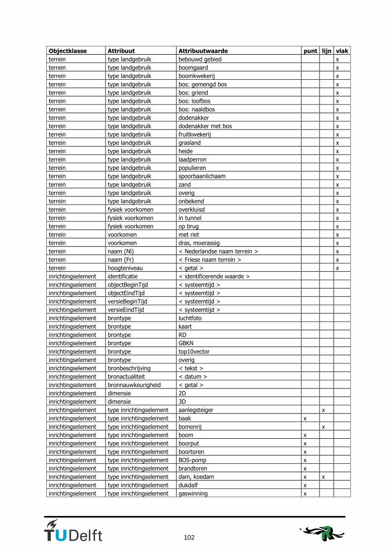
102
Objectklasse Attribuut Attribuutwaarde punt lijn vlak
terrein type landgebruik bebouwd gebied x
terrein type landgebruik boomgaard x
terrein type landgebruik boomkwekerij x
terrein type landgebruik bos: gemengd bos x
terrein type landgebruik bos: griend x
terrein type landgebruik bos: loofbos x
terrein type landgebruik bos: naaldbos x
terrein type landgebruik dodenakker x
terrein type landgebruik dodenakker met bos x
terrein type landgebruik fruitkwekerij x
terrein type landgebruik grasland x
terrein type landgebruik heide x
terrein type landgebruik laadperron x
terrein type landgebruik populieren x
terrein type landgebruik spoorbaanlichaam x
terrein type landgebruik zand x
terrein type landgebruik overig x
terrein type landgebruik onbekend x
terrein fysiek voorkomen overkluisd x
terrein fysiek voorkomen in tunnel x
terrein fysiek voorkomen op brug x
terrein voorkomen met riet x
terrein voorkomen dras, moerassig x
terrein naam (Nl) < Nederlandse naam terrein > x
terrein naam (Fr) < Friese naam terrein > x
terrein hoogteniveau < getal > x
inrichtingselement identificatie < identificerende waarde >
inrichtingselement objectBeginTijd < systeemtijd >
inrichtingselement objectEindTijd < systeemtijd >
inrichtingselement versieBeginTijd < systeemtijd >
inrichtingselement versieEindTijd < systeemtijd >
inrichtingselement brontype luchtfoto
inrichtingselement brontype kaart
inrichtingselement brontype RD
inrichtingselement brontype GBKN
inrichtingselement brontype top10vector
inrichtingselement brontype overig
inrichtingselement bronbeschrijving < tekst >
inrichtingselement bronactualiteit < datum >
inrichtingselement bronnauwkeurigheid < getal >
inrichtingselement dimensie 2D
inrichtingselement dimensie 3D
inrichtingselement type inrichtingselement aanlegsteiger x
inrichtingselement type inrichtingselement baak x
inrichtingselement type inrichtingselement bomenrij x
inrichtingselement type inrichtingselement boom x
inrichtingselement type inrichtingselement boorput x
inrichtingselement type inrichtingselement boortoren x
inrichtingselement type inrichtingselement BOS-pomp x
inrichtingselement type inrichtingselement brandtoren x
inrichtingselement type inrichtingselement dam, koedam x x
inrichtingselement type inrichtingselement dukdalf x
inrichtingselement type inrichtingselement gaswinning x

103
Objectklasse Attribuut Attribuutwaarde punt lijn vlak
inrichtingselement type inrichtingselement gedenkteken, monument x
inrichtingselement type inrichtingselement geluidswering x
inrichtingselement type inrichtingselement gemaal x
inrichtingselement type inrichtingselement golfmeetpaal x
inrichtingselement type inrichtingselement GPS kernnetpunt x
inrichtingselement type inrichtingselement grenspunt x
inrichtingselement type inrichtingselement heg, haag x
inrichtingselement type inrichtingselement hekwerk x
inrichtingselement type inrichtingselement helikopterlandingsplatform x
inrichtingselement type inrichtingselement hoogspanningsleiding x
inrichtingselement type inrichtingselement hoogspanningsmast x
inrichtingselement type inrichtingselement hunebed x
inrichtingselement type inrichtingselement kaap x
inrichtingselement type inrichtingselement kabelbaan x
inrichtingselement type inrichtingselement kabelbaanmast x
inrichtingselement type inrichtingselement kapel x
inrichtingselement type inrichtingselement kilometerpaal x
inrichtingselement type inrichtingselement kilometerpaal spoorweg x
inrichtingselement type inrichtingselement kilometerpaal water x
inrichtingselement type inrichtingselement kilometerraaibord x
inrichtingselement type inrichtingselement kilometerraaipaal x
inrichtingselement type inrichtingselement koeltoren x
inrichtingselement type inrichtingselement koepel x
inrichtingselement type inrichtingselement kogelvanger schietbaan x x
inrichtingselement type inrichtingselement kraan x
inrichtingselement type inrichtingselement kruis x
inrichtingselement type inrichtingselement laadperron x x
inrichtingselement type inrichtingselement leiding x
inrichtingselement type inrichtingselement licht, lichtopstand x
inrichtingselement type inrichtingselement lichttoren x
inrichtingselement type inrichtingselement luchtvaartlicht x
inrichtingselement type inrichtingselement markant object x
inrichtingselement type inrichtingselement muur x
inrichtingselement type inrichtingselement oliepompinstallatie x
inrichtingselement type inrichtingselement paal x
inrichtingselement type inrichtingselement paalwerk x
inrichtingselement type inrichtingselement peilmeetstation x
inrichtingselement type inrichtingselement peilschaal x
inrichtingselement type inrichtingselement pijler x
inrichtingselement type inrichtingselement radarpost x
inrichtingselement type inrichtingselement radiobaken x
inrichtingselement type inrichtingselement radiotelescoop x
inrichtingselement type inrichtingselement RD punt x
inrichtingselement type inrichtingselement schietbaan x
inrichtingselement type inrichtingselement schoorsteen x
inrichtingselement type inrichtingselement seinmast x
inrichtingselement type inrichtingselement sluisdeur x x
inrichtingselement type inrichtingselement station x
inrichtingselement type inrichtingselement stormvloedkering x
inrichtingselement type inrichtingselement strandpaal x
inrichtingselement type inrichtingselement strekdam, krib, golfbreker x
inrichtingselement type inrichtingselement stuw x x
inrichtingselement type inrichtingselement tol x x

104
Objectklasse Attribuut Attribuutwaarde punt lijn vlak
inrichtingselement type inrichtingselement toren x
inrichtingselement type inrichtingselement uitzichttoren x
inrichtingselement type inrichtingselement verkeersgeleider x
inrichtingselement type inrichtingselement visplaats x
inrichtingselement type inrichtingselement vlampijp x
inrichtingselement type inrichtingselement wegafsluiting x x
inrichtingselement type inrichtingselement wegwijzer x
inrichtingselement type inrichtingselement windmolen x
inrichtingselement type inrichtingselement windmolen: korenmolen x
inrichtingselement type inrichtingselement windmolen: watermolen x
inrichtingselement type inrichtingselement windmolentje x
inrichtingselement type inrichtingselement windturbine x
inrichtingselement type inrichtingselement zeevaartlicht x
inrichtingselement type inrichtingselement zendmast x
inrichtingselement type inrichtingselement zichtbaar wrak x
inrichtingselement type inrichtingselement overig x x
inrichtingselement type inrichtingselement onbekend x x
inrichtingselement hoogte < hoogte boven maaiveld in meters > x x
inrichtingselement naam (Nl) < Nederlandse naam inrichtingselement > x x
inrichtingselement naam (Fr) < Friese naam inrichtingselement > x x
inrichtingselement nummer < nummer inrichtingselement > x x
inrichtingselement status realisatie: nog niet in uitvoering x x
inrichtingselement status realisatie: in uitvoering x x
inrichtingselement status in gebruik x x
inrichtingselement status buiten gebruik x x
inrichtingselement status onbekend x x
inrichtingselement hoogteniveau < getal > x x
reliëf identificatie < identificerende waarde >
reliëf objectBeginTijd < systeemtijd >
reliëf objectEindTijd < systeemtijd >
reliëf versieBeginTijd < systeemtijd >
reliëf versieEindTijd < systeemtijd >
reliëf brontype luchtfoto
reliëf brontype kaart
reliëf brontype RD
reliëf brontype GBKN
reliëf brontype top10vector
reliëf brontype overig
reliëf bronbeschrijving < tekst >
reliëf bronactualiteit < datum >
reliëf bronnauwkeurigheid < getal >
reliëf dimensie 2D
reliëf dimensie 3D
reliëf type reliëf dieptelijn x
reliëf type reliëf dieptepunt x
reliëf type reliëf hoogtelijn x
reliëf type reliëf hoogtepunt x
reliëf type reliëf kade, wal x
reliëf type reliëf laagwaterlijn x
reliëf type reliëf peil x
reliëf type reliëf peil: winterpeil x
reliëf type reliëf peil: zomerpeil x
reliëf type reliëf talud, hoogteverschil x
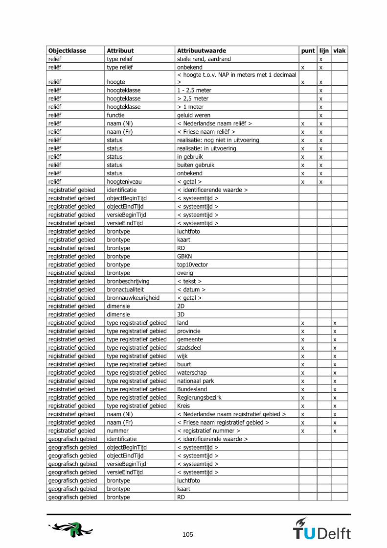
105
Objectklasse Attribuut Attribuutwaarde punt lijn vlak
reliëf type reliëf steile rand, aardrand x
reliëf type reliëf onbekend x x
reliëf hoogte < hoogte t.o.v. NAP in meters met 1 decimaal > x x
reliëf hoogteklasse 1 - 2,5 meter x
reliëf hoogteklasse > 2,5 meter x
reliëf hoogteklasse > 1 meter x
reliëf functie geluid weren x
reliëf naam (Nl) < Nederlandse naam reliëf > x x
reliëf naam (Fr) < Friese naam reliëf > x x
reliëf status realisatie: nog niet in uitvoering x x
reliëf status realisatie: in uitvoering x x
reliëf status in gebruik x x
reliëf status buiten gebruik x x
reliëf status onbekend x x
reliëf hoogteniveau < getal > x x
registratief gebied identificatie < identificerende waarde >
registratief gebied objectBeginTijd < systeemtijd >
registratief gebied objectEindTijd < systeemtijd >
registratief gebied versieBeginTijd < systeemtijd >
registratief gebied versieEindTijd < systeemtijd >
registratief gebied brontype luchtfoto
registratief gebied brontype kaart
registratief gebied brontype RD
registratief gebied brontype GBKN
registratief gebied brontype top10vector
registratief gebied brontype overig
registratief gebied bronbeschrijving < tekst >
registratief gebied bronactualiteit < datum >
registratief gebied bronnauwkeurigheid < getal >
registratief gebied dimensie 2D
registratief gebied dimensie 3D
registratief gebied type registratief gebied land x x
registratief gebied type registratief gebied provincie x x
registratief gebied type registratief gebied gemeente x x
registratief gebied type registratief gebied stadsdeel x x
registratief gebied type registratief gebied wijk x x
registratief gebied type registratief gebied buurt x x
registratief gebied type registratief gebied waterschap x x
registratief gebied type registratief gebied nationaal park x x
registratief gebied type registratief gebied Bundesland x x
registratief gebied type registratief gebied Regierungsbezirk x x
registratief gebied type registratief gebied Kreis x x
registratief gebied naam (Nl) < Nederlandse naam registratief gebied > x x
registratief gebied naam (Fr) < Friese naam registratief gebied > x x
registratief gebied nummer < registratief nummer > x x
geografisch gebied identificatie < identificerende waarde >
geografisch gebied objectBeginTijd < systeemtijd >
geografisch gebied objectEindTijd < systeemtijd >
geografisch gebied versieBeginTijd < systeemtijd >
geografisch gebied versieEindTijd < systeemtijd >
geografisch gebied brontype luchtfoto
geografisch gebied brontype kaart
geografisch gebied brontype RD

106
Objectklasse Attribuut Attribuutwaarde punt lijn vlak
geografisch gebied brontype GBKN
geografisch gebied brontype top10vector
geografisch gebied brontype overig
geografisch gebied bronbeschrijving < tekst >
geografisch gebied bronactualiteit < datum >
geografisch gebied bronnauwkeurigheid < getal >
geografisch gebied dimensie 2D
geografisch gebied dimensie 3D
geografisch gebied type geografisch gebied bank, ondiepte, plaat x x
geografisch gebied type geografisch gebied bosgebied x x
geografisch gebied type geografisch gebied buurtschap x x
geografisch gebied type geografisch gebied duingebied x x
geografisch gebied type geografisch gebied eiland x x
geografisch gebied type geografisch gebied geul, vaargeul x x
geografisch gebied type geografisch gebied heidegebied x x
geografisch gebied type geografisch gebied heuvel, berg x x
geografisch gebied type geografisch gebied huizengroep x x
geografisch gebied type geografisch gebied kaap, hoek x x
geografisch gebied type geografisch gebied meer, plas, ven, vijver x x
geografisch gebied type geografisch gebied plaats, bewoond oord x x
geografisch gebied type geografisch gebied polder x x
geografisch gebied type geografisch gebied streek, veld x x
geografisch gebied type geografisch gebied terp x x
geografisch gebied type geografisch gebied vliedberg x x
geografisch gebied type geografisch gebied wad x x
geografisch gebied type geografisch gebied woonwijk x x
geografisch gebied type geografisch gebied zee x x
geografisch gebied type geografisch gebied zeegat, zeearm x x
geografisch gebied type geografisch gebied overig x x
geografisch gebied type geografisch gebied onbekend x x
geografisch gebied aantal inwoners < nummer > x x
geografisch gebied naam (Nl) < Nederlandse naam geografisch gebied > x x
geografisch gebied naam (Fr) < Friese naam geografisch gebied > x x
functioneel gebied identificatie < identificerende waarde >
functioneel gebied objectBeginTijd < systeemtijd >
functioneel gebied objectEindTijd < systeemtijd >
functioneel gebied versieBeginTijd < systeemtijd >
functioneel gebied versieEindTijd < systeemtijd >
functioneel gebied brontype luchtfoto
functioneel gebied brontype kaart
functioneel gebied brontype RD
functioneel gebied brontype GBKN
functioneel gebied brontype top10vector
functioneel gebied brontype overig
functioneel gebied bronbeschrijving < tekst >
functioneel gebied bronactualiteit < datum >
functioneel gebied bronnauwkeurigheid < getal >
functioneel gebied dimensie 2D
functioneel gebied dimensie 3D
functioneel gebied type functioneel gebied arboretum x x
functioneel gebied type functioneel gebied bedrijventerrein x x
functioneel gebied type functioneel gebied begraafplaats x x
functioneel gebied type functioneel gebied boswachterij x x
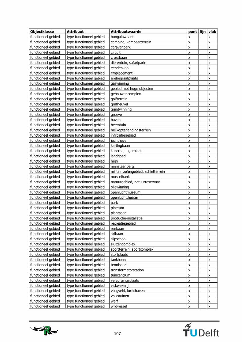
107
Objectklasse Attribuut Attribuutwaarde punt lijn vlak
functioneel gebied type functioneel gebied bungalowpark x x
functioneel gebied type functioneel gebied camping, kampeerterrein x x
functioneel gebied type functioneel gebied caravanpark x x
functioneel gebied type functioneel gebied circuit x x
functioneel gebied type functioneel gebied crossbaan x x
functioneel gebied type functioneel gebied dierentuin, safaripark x x
functioneel gebied type functioneel gebied eendenkooi x x
functioneel gebied type functioneel gebied emplacement x x
functioneel gebied type functioneel gebied erebegraafplaats x x
functioneel gebied type functioneel gebied gaswinning x x
functioneel gebied type functioneel gebied gebied met hoge objecten x x
functioneel gebied type functioneel gebied gebouwencomplex x x
functioneel gebied type functioneel gebied golfterrein x x
functioneel gebied type functioneel gebied grafheuvel x x
functioneel gebied type functioneel gebied grindwinning x x
functioneel gebied type functioneel gebied groeve x x
functioneel gebied type functioneel gebied haven x x
functioneel gebied type functioneel gebied heemtuin x x
functioneel gebied type functioneel gebied helikopterlandingsterrein x x
functioneel gebied type functioneel gebied infiltratiegebied x x
functioneel gebied type functioneel gebied jachthaven x x
functioneel gebied type functioneel gebied kartingbaan x x
functioneel gebied type functioneel gebied kazerne, legerplaats x x
functioneel gebied type functioneel gebied landgoed x x
functioneel gebied type functioneel gebied mijn x x
functioneel gebied type functioneel gebied mijnsteenberg x x
functioneel gebied type functioneel gebied militair oefengebied, schietterrein x x
functioneel gebied type functioneel gebied mosselbank x x
functioneel gebied type functioneel gebied natuurgebied, natuurreservaat x x
functioneel gebied type functioneel gebied oliewinning x x
functioneel gebied type functioneel gebied openluchtmuseum x x
functioneel gebied type functioneel gebied openluchttheater x x
functioneel gebied type functioneel gebied park x x
functioneel gebied type functioneel gebied pinetum x x
functioneel gebied type functioneel gebied plantsoen x x
functioneel gebied type functioneel gebied productie-installatie x x
functioneel gebied type functioneel gebied recreatiegebied x x
functioneel gebied type functioneel gebied renbaan x x
functioneel gebied type functioneel gebied skibaan x x
functioneel gebied type functioneel gebied slipschool x x
functioneel gebied type functioneel gebied sluizencomplex x x
functioneel gebied type functioneel gebied sportterrein, sportcomplex x x
functioneel gebied type functioneel gebied stortplaats x x
functioneel gebied type functioneel gebied tankbaan x x
functioneel gebied type functioneel gebied tennispark x x
functioneel gebied type functioneel gebied transformatorstation x x
functioneel gebied type functioneel gebied tuincentrum x x
functioneel gebied type functioneel gebied verzorgingsplaats x x
functioneel gebied type functioneel gebied viskwekerij x x
functioneel gebied type functioneel gebied vliegveld, luchthaven x x
functioneel gebied type functioneel gebied volkstuinen x x
functioneel gebied type functioneel gebied werf x x
functioneel gebied type functioneel gebied wildwissel x x

108
Objectklasse Attribuut Attribuutwaarde punt lijn vlak
functioneel gebied type functioneel gebied windturbinepark x x
functioneel gebied type functioneel gebied woonwagencentrum x x
functioneel gebied type functioneel gebied ijsbaan x x
functioneel gebied type functioneel gebied zandwinning x x
functioneel gebied type functioneel gebied zenderpark x x
functioneel gebied type functioneel gebied zoutwinning x x
functioneel gebied type functioneel gebied zuiveringsinstallatie x x
functioneel gebied type functioneel gebied zweefvliegveldterrein x x
functioneel gebied type functioneel gebied zwembad complex x x
functioneel gebied type functioneel gebied onbekend x x
functioneel gebied naam (Nl) < Nederlandse naam functioneel gebied > x x
functioneel gebied naam (Fr) < Friese naam functioneel gebied > x x
Note: This table has also been used and is made in cooperation with the project group IMTop.

109
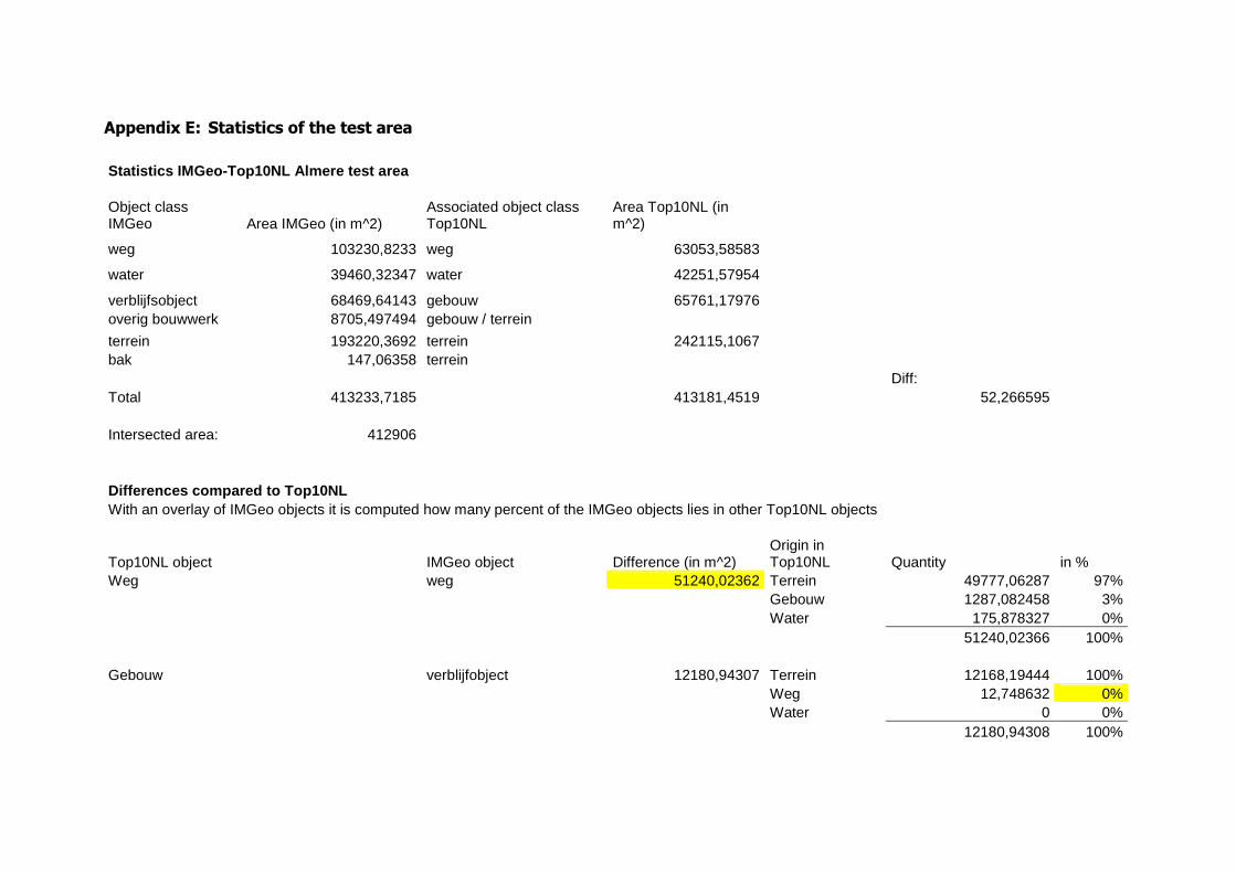
Appendix E: Statistics of the test area
Statistics IMGeo-Top10NL Almere test area Object class IMGeo Area IMGeo (in m^2)
Associated object class Top10NL
Area Top10NL (in m^2)
weg 103230,8233 weg 63053,58583
water 39460,32347 water 42251,57954
verblijfsobject 68469,64143 gebouw 65761,17976 overig bouwwerk 8705,497494 gebouw / terrein
terrein 193220,3692 terrein 242115,1067 bak 147,06358 terrein Diff: Total 413233,7185 413181,4519 52,266595 Intersected area: 412906 Differences compared to Top10NL With an overlay of IMGeo objects it is computed how many percent of the IMGeo objects lies in other Top10NL objects
Top10NL object IMGeo object Difference (in m^2) Origin in Top10NL Quantity in %
Weg weg 51240,02362 Terrein 49777,06287 97% Gebouw 1287,082458 3% Water 175,878327 0% 51240,02366 100% Gebouw verblijfobject 12180,94307 Terrein 12168,19444 100% Weg 12,748632 0% Water 0 0% 12180,94308 100%

Water Water 976,458563 Terrein 692,695285 71% Weg 283,763256 29% Gebouw 0 0% 976,458541 100% Terrein terrein 22576,09849 Weg 10799,28792 48% bak Gebouw 8184,184136 36% overig bouwwerk Water 3606,396973 16% 22589,86903 100% Percentage of the object class that is classified differently in the other model
Top10NL Area in IMGeo Area in Top10NL Overlapping area Percentage w.r.t.
IMGeo Top10NL
weg 103230,8233 63053,58583 52438,23929 51% 83% water 39460,32347 42251,57954 38483,86494 98% 91% gebouw 68469,64143 65761,17976 56288,69844 82% 86% terrein 202072,9303 242115,1067 179496,8319 89% 74% Total 413233,7185 413181,4519 326707,6345 79% 79%

112
Appendix F: Python scripts
The next script is used for the ‘maximum area method’ as described in subsection 5.5.2. The ‘#’ indicates comments. The comments in the code tell what happens at what stage in the code. # --------------------------------------------------------------------------- # Script name: AssignIMGeotoTop10ID.py # Description: This script follows the script 'AppendTop10ID'. # This script resulted in a shapefile with all the IMGeo objects which (partially) # overlap Top10NL objects. In this script a choice is made to which of these Top10NL # objects the IMGeo objects are to be assigned. In this first case just the Top10NL # object which has the largest overlap with the IMGeo object will become the Region Class # of this IMGeo object. # Created on: fr dec 6 2007 12:29:05 # (generated by ArcGIS/ModelBuilder) # --------------------------------------------------------------------------- # Import system modules import sys, string, os, arcgisscripting import math import time from sets import Set # Create the Geoprocessor object gp = arcgisscripting.create() # Set the necessary product code gp.SetProduct("ArcView") # Load required toolboxes... gp.AddToolbox("C:/Program Files/ESR_ArcGisDesktop92EN/ArcGIS/ArcToolbox/Toolboxes/Conversion Tools.tbx") gp.AddToolbox("C:/Program Files/ESR_ArcGisDesktop92EN/ArcGIS/ArcToolbox/Toolboxes/Data Management Tools.tbx") gp.AddToolbox("C:/Program Files/ESR_ArcGisDesktop92EN/ArcGIS/ArcToolbox/Toolboxes/Analysis Tools.tbx") # Input features: IMGeo_Merge = "\\\\GWfiler02\\13712data$\\Afstuderen\\Data\\Geodatabase\\Personal Geodatabase.mdb\\Dataset\\IMGeo_Merge_new2" AppendTop10ID_2 = "\\\\GWfiler02\\13712data$\\Afstuderen\\Data\\Geodatabase\\Personal Geodatabase.mdb\\Dataset\\AppendTop10ID_2" IMGeo_SpatialJoin = "\\\\GWfiler02\\13712data$\\Afstuderen\\Data\\Geodatabase\\Personal Geodatabase.mdb\\Dataset\\IMGeo_merge_SpatialJoin_new2" IMGeoTop10NLFinal1b = "\\\\GWfiler02\\13712data$\\Afstuderen\\Data\\Geodatabase\\Personal Geodatabase.mdb\\Dataset\\IMGeoTop10NLFinal1b" # Search for the next GML_ID in IMGeo_Merge a=1 for i in range(4159): # Loop over all the values GML_ID can have. These records are selected from the # 'AppendTop10ID' shapefile, which contains the areas of the clipped IMGeo objects. b=str(a) x = "\\\\GWfiler02\\13712data$\\Afstuderen\\Data\\Geodatabase\\Personal Geodatabase.mdb\\Troep\\" + b gp.Select(AppendTop10ID_2, x, "[GML_ID] = %s*%s" %(a, 1)) # The area of the parts of the GML-ID shapes are compared here. The object with the # largest area is the object to which the GML-ID finally is assigned to. rows = gp.SearchCursor(x) row = rows.next() values = Set() while row:

113
fields = gp.ListFields(x) field = fields.next() while field: if field.name == "SHAPE_Area": values.add(row.GetValue(field.name)) SHAPE_Area = field.name field = fields.next() row = rows.next() # Now the maximum of the areas is computed. c = max(values) y = "\\\\GWfiler02\\13712data$\\Afstuderen\\Data\\Geodatabase\\Personal Geodatabase.mdb\\Troep\\" + b + "a" gp.select(AppendTop10ID_2, y, "[%s] < %s+0.000001 AND [%s] > %s-0.000001 AND [GML_ID] = %s*%s" %(SHAPE_Area, c, SHAPE_Area, c, a, 1)) # Now the Top10ID of the 'winning' area is selected in order to be able to extract the right value from # the IMGeo_SpatialJoin shape. rows = gp.SearchCursor(y) row2 = rows.next() d = 0 while row2: fields = gp.ListFields(y) field2 = fields.next() while field2: if field2.name == "Top10ID": d = row2.GetValue(field2.name) field2 = fields.next() row2 = rows.next() z = "\\\\GWfiler02\\13712data$\\Afstuderen\\Data\\Geodatabase\\Personal Geodatabase.mdb\\Troep\\" + b + "b" # The selection that is made has two parameters: b for the right GML-ID and d for the right Top10NL-ID. gp.select(IMGeo_SpatialJoin, z, "[GML_ID] = %s*%s AND [Top10ID] = %s*%s" %(b, 1, d, 1)) # This selection is appended to the final result. gp.Append_management(z, IMGeoTop10NLFinal1b, "TEST", IMGeoTop10NLFinal1b) time.sleep(0.2) # The database lock is removed with the statement 'Refresh Catalog'. This enables us to delete the files we don't # need anymore after having processed this one GML-ID. gp.RefreshCatalog("\\\\GWfiler02\\13712data$\\Afstuderen\\Data\\Geodatabase\\Personal Geodatabase.mdb") try: gp.delete(x) gp.delete(y) gp.delete(z) except: print 'Jammer dan' a=a+1

114
The next script is used to select all objects that are to be split according to the 35%-split method. # Import system modules import sys, string, os, arcgisscripting import math import time from sets import Set # Create the Geoprocessor object gp = arcgisscripting.create() # Set the necessary product code gp.SetProduct("ArcView") # Load required toolboxes... gp.AddToolbox("C:/Program Files/ESR_ArcGisDesktop92EN/ArcGIS/ArcToolbox/Toolboxes/Conversion Tools.tbx") gp.AddToolbox("C:/Program Files/ESR_ArcGisDesktop92EN/ArcGIS/ArcToolbox/Toolboxes/Data Management Tools.tbx") gp.AddToolbox("C:/Program Files/ESR_ArcGisDesktop92EN/ArcGIS/ArcToolbox/Toolboxes/Analysis Tools.tbx") # Input features: IMGeo_Merge = "\\\\GWfiler02\\13712data$\\Afstuderen\\Data\\Geodatabase\\Personal Geodatabase.mdb\\Dataset\\IMGeo_Merge_new3" AppendTop10ID_2 = "\\\\GWfiler02\\13712data$\\Afstuderen\\Data\\Geodatabase\\Personal Geodatabase.mdb\\Dataset\\AppendTop10ID_3_Erase2" IMGeo_SpatialJoin = "\\\\GWfiler02\\13712data$\\Afstuderen\\Data\\Geodatabase\\Personal Geodatabase.mdb\\Dataset\\IMGeo_merge_SpatialJoin_new3" IMGeoTop10NLFinal1b = "\\\\GWfiler02\\13712data$\\Afstuderen\\Data\\Geodatabase\\Personal Geodatabase.mdb\\Dataset\\IMGeoTop10NLFinal2b" split35 = "\\\\GWfiler02\\13712data$\\Afstuderen\\Data\\Geodatabase\\Personal Geodatabase.mdb\\Dataset\\splitfeatures35" maxGML = 4159 a=1 for i in range(4159): b=str(a) try: x = "\\\\GWfiler02\\13712data$\\Afstuderen\\Data\\Geodatabase\\Personal Geodatabase.mdb\\Troep\\" + b gp.Select(AppendTop10ID_2, x, "[GML_ID] = %s*%s" %(a, 1)) rows = gp.SearchCursor(x) row = rows.next() values = [] e = 0 f = 0 h = 0 m = 0 while row: fields = gp.ListFields(x) field = fields.next() while field: if field.name == "Top10ID": h = row.GetValue(field.name) if field.name == "SHAPE_Area": e = row.GetValue(field.name) SHAPE_Area = field.name if field.name == "Area": f = row.GetValue(field.name) Area = field.name field = fields.next() g = e/f if g > 0.35: values.append(h)
115
row = rows.next() if len(values) == 2: maxGML = maxGML + 1 k = values[0] l = values[1] w = "\\\\GWfiler02\\13712data$\\Afstuderen\\Data\\Geodatabase\\Personal Geodatabase.mdb\\Troep\\" + b + "c" gp.select(AppendTop10ID_2, w, "[GML_ID] = %s*%s AND [Top10ID] = %s*%s" %(b, 1, k, 1)) gp.calculatefield(w, "GML_ID", maxGML) gp.append(w, split35, "TEST", split35) gp.RefreshCatalog("\\\\GWfiler02\\13712data$\\Afstuderen\\Data\\Geodatabase\\Personal Geodatabase.mdb") try: gp.delete(w) except: print 'Jammer dan' gp.RefreshCatalog("\\\\GWfiler02\\13712data$\\Afstuderen\\Data\\Geodatabase\\Personal Geodatabase.mdb") try: gp.delete(x) except: print 'Jammer dan' except: print 'Deze heb ik eruit gehaald' a=a+1

116
Appendix G: tGAP code in PL/SQL
The code of the constrained tGAP has been produced by Jan Haunert and Arta Dilo, only small modifications are made to this by the author. The procedure build calls all other procedures; first the getNextImportantFace procedure to determine the least important face, after that the most compatible neighhour is determined in the function getMost CompatibleNeighbour, after that the faces are merged in the procedure mergeFace. In this procedure mergeFace the modifications are saved to the table. At the end of the iteration step the edges and faces that were removed receive the value of the iteration step as their imp_high value. Because of this the output can be generated at all possible importance steps, i.e. at all different scales. The complete constrained tGAP code used in this research without weights is: create or replace procedure build is newFaceID number; minImpFaceID number := 0; minImpFaceArea number := 0; mostCompNeighbourID number; importance pls_integer := 1; begin select max(face_id) into newFaceID from ARJEN_FACES; getNextImportantFace(minImpFaceArea, minImpFaceID); while minImpFaceID > 0 loop mostCompNeighbourID := getMostCompatibleNeighbour( minImpFaceID ); if mostCompNeighbourID <> 0 then newFaceID := newFaceID + 1; mergeFace(mostCompNeighbourID, minImpFaceID, newFaceID, importance); importance := importance + 1; end if; getNextImportantFace(minImpFaceArea, minImpFaceID); end loop; endRemainingEdges(importance); endRemainingFaces(importance); end; ======================================================= create or replace procedure endEdges(faceID in number, importance in number) is begin execute immediate 'update ARJEN_EDGES set IMP_HIGH = :1 where IMP_HIGH = 0 and (LEFT_FACE_ID = :2 or RIGHT_FACE_ID = :3)' using importance, faceID, faceID; commit; end; ======================================================= create or replace procedure endFace(faceID in number, importance in number) is begin execute immediate
117
'update ARJEN_FACES set IMP_HIGH = :1 where IMP_HIGH = 0 and FACE_ID = :2' using importance, faceID; commit; end; ======================================================= create or replace procedure endRemainingEdges(importance in number) is begin execute immediate 'update ARJEN_EDGES set IMP_HIGH = :1 where IMP_HIGH = 0' using importance; commit; end; create or replace procedure endRemainingFaces(importance in number) is begin execute immediate 'update ARJEN_FACES set IMP_HIGH = :1 where IMP_HIGH = 0' using importance; commit; end; ======================================================= create or replace procedure getNextImportantFace(faceArea in out number, faceID in out number) is nextFaceArea number :=0; nextFaceID number :=0; begin select min(area) into nextFaceArea from ARJEN_FACES where imp_high = 0 and (area > faceArea or (area = faceArea and face_id > faceID)); select min(face_id) into nextFaceID from ARJEN_FACES where imp_high = 0 and area = nextFaceArea and (area > faceArea or (area = faceArea and face_id > faceID)); faceArea := nextFaceArea; faceID := nextFaceID; end; =======================================================

118
create or replace procedure mergeFace(faceA in number, faceB in number, newFaceID in number, importance in number) is newArea number; newClass char; newRegion number; newRegionClass char; oldEdges id_list; oldEdgeID number; oldEdgeGeoID number; oldLeftFaceID number; oldRightFaceID number; newEdgeID number; begin select sum(AREA) into newArea from ARJEN_FACES where FACE_ID = faceA or FACE_ID = faceB; select CLASS, IDENT, REGION_CLA into newClass, newRegion, newRegionClass from ARJEN_FACES where FACE_ID = faceA; storeNewFace(newFaceID, importance, newArea, newClass, newRegion, newRegionClass); select max(EDGE_ID) into newEdgeID from ARJEN_EDGES; select EDGE_ID bulk collect into oldEdges from ARJEN_EDGES where imp_high = 0 and ((LEFT_FACE_ID = faceA and RIGHT_FACE_ID <> faceB) or (RIGHT_FACE_ID = faceA and LEFT_FACE_ID <> faceB) or (LEFT_FACE_ID = faceB and RIGHT_FACE_ID <> faceA) or (RIGHT_FACE_ID = faceB and LEFT_FACE_ID <> faceA)); for i in 1 .. oldEdges.count loop oldEdgeID := oldEdges(i); newEdgeID := newEdgeID + 1; select EDGE_GEO_ID, LEFT_FACE_ID, RIGHT_FACE_ID into oldEdgeGeoID, oldLeftFaceID, oldRightFaceID from ARJENEDGE where EDGE_ID = oldEdgeID; if oldRightFaceID = faceA or oldRightFaceID = faceB then storeNewEdge(newEdgeID, importance, oldEdgeGeoID, oldLeftFaceID, newFaceID); else storeNewEdge(newEdgeID, importance, oldEdgeGeoID, newFaceID, oldRightFaceID); end if; end loop; endEdges(faceA, importance); endEdges(faceB, importance); endFace(faceA, importance); endFace(faceB, importance); end; =======================================================
119
create or replace procedure storeNewEdge(edgeID in number, importance in number, edgeGeoID in number, leftFaceID in number, rightFaceID in number) is begin execute immediate 'insert into ARJEN_EDGES (EDGE_ID, IMP_LOW, IMP_HIGH, EDGE_GEO_ID, LEFT_FACE_ID, RIGHT_FACE_ID) values (:1, :2, 0, :3, :4, :5)' using edgeID, importance, edgeGeoID, leftFaceID, rightFaceID; commit; end; ======================================================= create or replace procedure storeNewFace(faceID in number, importance in number, area in number, class in number, region in number, regionclass in number) is begin execute immediate 'insert into ARJEN_FACES (FACE_ID, IMP_LOW, IMP_HIGH, AREA, CLASS, REGION, REGION_CLA) values (:1, :2, 0, :4, :5, :6, :7)' using faceID, importance, area, class, region, regionclass; commit; end; ======================================================= create or replace function getMostCompatibleNeighbour (faceA in number) return number is classA number; regionA number; areaA number; regionclassA number; faces id_list; classTemp number; regionTemp number; costTemp number; costBest number := -1; faceBest number := 0; n number; begin --query attributes of faceA select class, TOP10ID, area, REGION_CLASS into classA, regionA, areaA, regionclassA from ARJEN_FACES where imp_high = 0 and face_id = faceA; --select all neighbours of faceA select distinct (left_face_id + right_face_id - faceA) bulk collect into faces from ARJEN_EDGES where imp_high = 0 and (right_face_id = faceA or left_face_id = faceA); --iterate through neighbours for i in 1 .. faces.count

120
loop --query attributes of neighbour select count(*) into n from ARJENFACE where imp_high = 0 and face_id = faces(i); if n >= 1 then select class, TOP10ID, into classTemp, regionTemp, from ARJEN_FACES where imp_high = 0 and face_id = faces(i); --if neighbour is in same region, then calculate cost if regionTemp = regionA then select cost into costTemp from SIMILARITIES where class1 = classA and class2 = classTemp; costTemp := costTemp * areaA; --keep the neighbour with lowest cost if costTemp < costBest or costBest = -1 then if n = 1 then select class, REGION_CLA into classtest, Regionclasstest from faces; if classtest <> Regionclasstest then Regionclasstest := classtest; end if; end if; faceBest := faces(i); costBest := costTemp; end if; end if; end if; end loop; return faceBest; end; =======================================================
For the implementation of the weights the procedure getNextImportantFace needed to be changed: create or replace procedure getNextImportantFace(faceArea in out number, faceID in out number) is nextFaceArea number :=0; nextFaceID number :=0; begin select min(f.area * w.weights) into nextFaceArea from ARJEN_FACES f, WEIGHTS w where f.class = w.class and imp_high = 0 and (f.area * w.weights > faceArea or (f.area * w.weights = faceArea and face_id > faceID)); select min(face_id) into nextFaceID from ARJEN_FACES f, WEIGHTS w where f.class = w.class and

121
f.area * w.weights = nextFaceArea and imp_high = 0 and (f.area * w.weights > faceArea or (f.area * w.weights = faceArea and face_id > faceID)); faceArea := nextFaceArea; faceID := nextFaceID; end; =======================================================
To run the tGAP without constraint the procedure getMostCompatibleNeighbour needed to be changed: create or replace function getMostCompatibleNeighbour (faceA in number) return number is classA number; regionA number; areaA number; faces id_list; classTemp number; regionTemp number; costTemp number; costBest number := -1; faceBest number := 0; n number; begin --query attributes of faceA select class, TOP10ID, area into classA, regionA, areaA from ARJEN_FACES where imp_high = 0 and face_id = faceA; --select all neighbours of faceA select distinct (left_face_id + right_face_id - faceA) bulk collect into faces from ARJEN_EDGES where imp_high = 0 and (right_face_id = faceA or left_face_id = faceA); --iterate through neighbours for i in 1 .. faces.count loop --query attributes of neighbour select count(*) into n from ARJEN_FACES where imp_high = 0 and face_id = faces(i); if n > 0 then select class

122
into classTemp from ARJEN_FACES where imp_high = 0 and face_id = faces(i); select cost into costTemp from SIMILARITIES where class1 = classA and class2 = classTemp; costTemp := costTemp * areaA; --keep the neighbour with lowest cost if costTemp < costBest or costBest = -1 then faceBest := faces(i); costBest := costTemp; end if; end if; end if; end loop; return faceBest; end; =======================================================

123
Appendix H: Visualised results of the constrained tGAP
This appendix shows all intermediate results of the generalisation of the test data used in chapter 5. In all cases 8 intermediate steps were recorded to give a good view of the progress in the generalisation. This appendix starts with the simple overlay method, both with and without weights, after that the maximum area method, the 35%-split method and the building first method. The starting point of all cases, for reference, is the same: the IMGeo as visualised beneath.
The original IMGeo test dataset

124
Simple overlay without weights; importance =1000
Simple overlay without weights; importance =2000

125
Simple overlay without weights; importance =3000
Simple overlay without weights; importance =4000

126
Simple overlay without weights; importance =5000
Simple overlay without weights; importance =6000

127
Simple overlay without weights; importance =7000
Simple overlay without weights; importance =7702
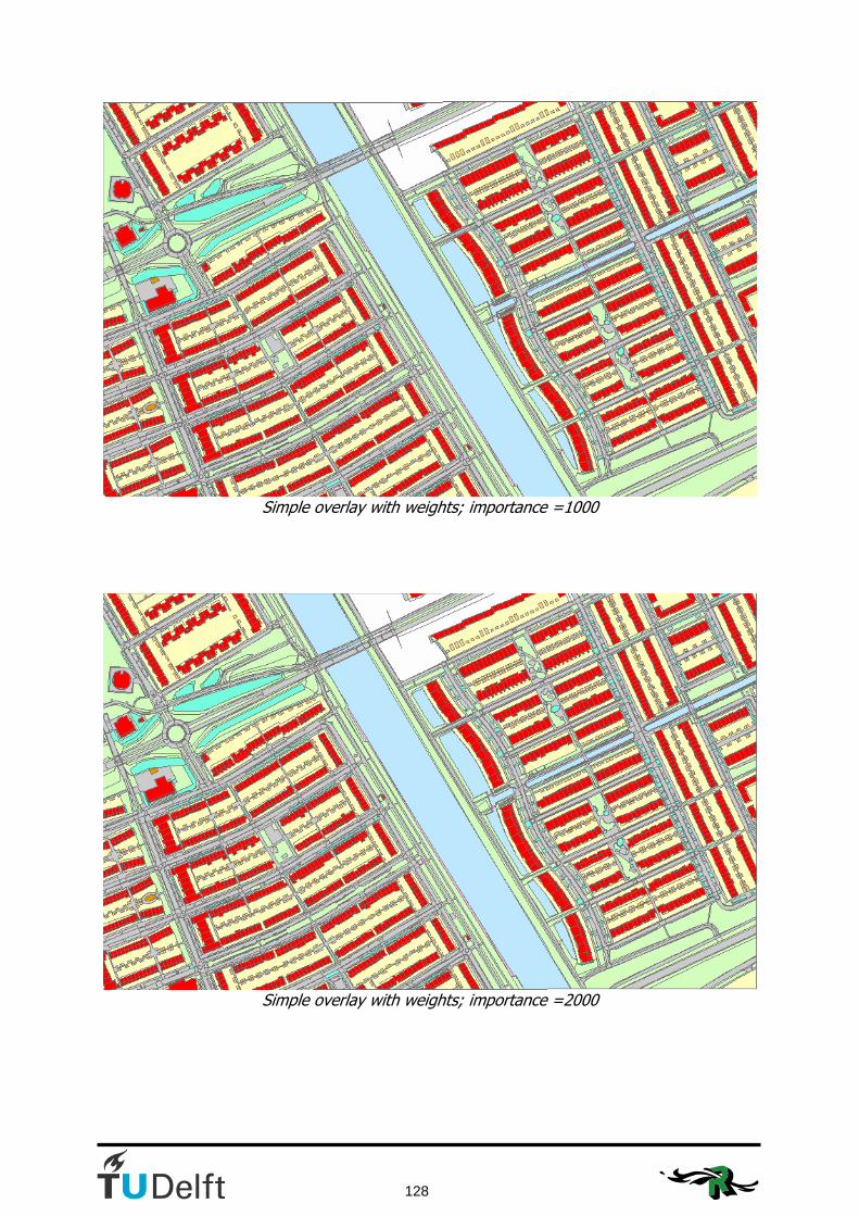
128
Simple overlay with weights; importance =1000
Simple overlay with weights; importance =2000

129
Simple overlay with weights; importance =3000
Simple overlay with weights; importance =4000

130
Simple overlay with weights; importance =5000
Simple overlay with weights; importance =6000

131
Simple overlay with weights; importance =7702
Simple overlay with weights; importance =7702

132
Maximum area method without weights; importance=500
Maximum area method without weights; importance=1000

133
Maximum area method without weights; importance=1500
Maximum area method without weights; importance=2000

134
Maximum area method without weights; importance=2500
Maximum area method without weights; importance=3000
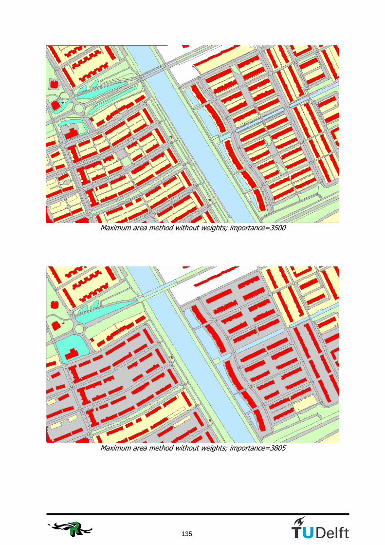
135
Maximum area method without weights; importance=3500
Maximum area method without weights; importance=3805
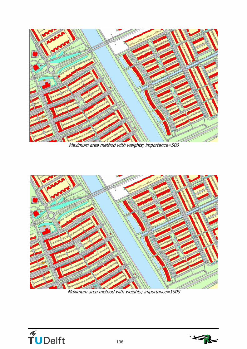
136
Maximum area method with weights; importance=500
Maximum area method with weights; importance=1000

137
Maximum area method with weights; importance=1500
Maximum area method with weights; importance=2000

138
Maximum area method with weights; importance=2500
Maximum area method with weights; importance=3000

139
Maximum area method with weights; importance=3500
Maximum area method with weights; importance=3805

140
35%-split method without weights; importance=500
35%-split method without weights; importance=1000

141
35%-split method without weights; importance=1500
35%-split method without weights; importance=2000
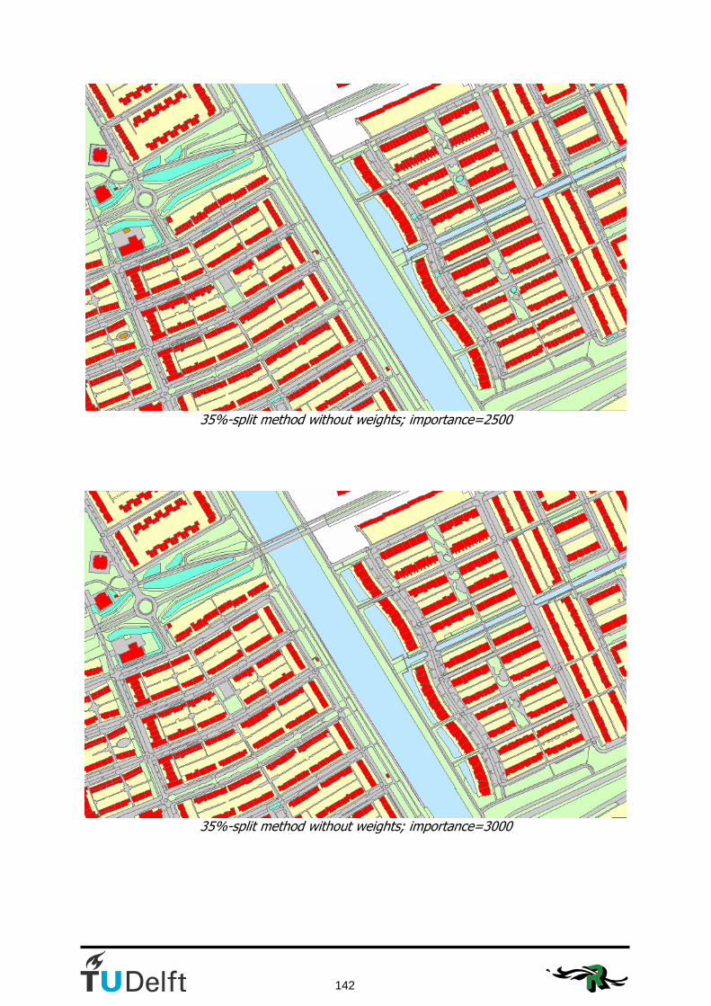
142
35%-split method without weights; importance=2500
35%-split method without weights; importance=3000

143
35%-split method without weights; importance=3500
35%-split method without weights; importance=4041

144
35%-split method with weights; importance=500
35%-split method with weights; importance=1000

145
35%-split method with weights; importance=1500
35%-split method with weights; importance=2000
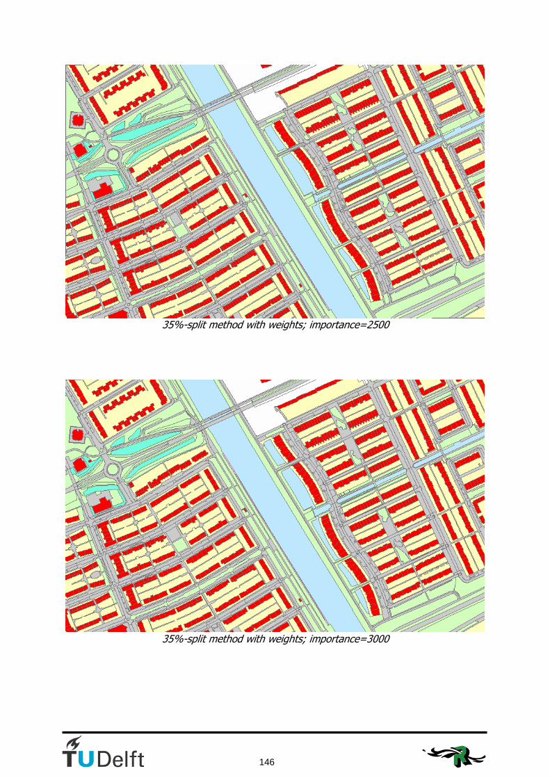
146
35%-split method with weights; importance=2500
35%-split method with weights; importance=3000
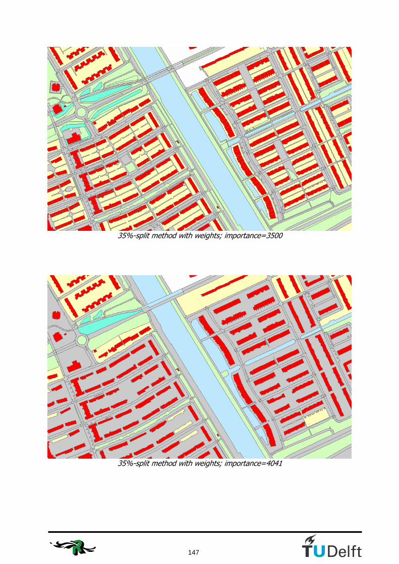
147
35%-split method with weights; importance=3500
35%-split method with weights; importance=4041

148
Building first method without weights; importance=500
Building first method without weights; importance=1000

149
Building first method without weights; importance=1500
Building first method without weights; importance=2000
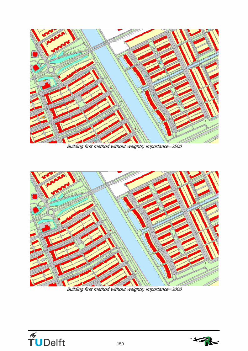
150
Building first method without weights; importance=2500
Building first method without weights; importance=3000

151
Building first method without weights; importance=3500
Building first method without weights; importance=3805

152
Building first method with weights; importance=500
Building first method with weights; importance=1000

153
Building first method with weights; importance=1500
Building first method with weights; importance=2000
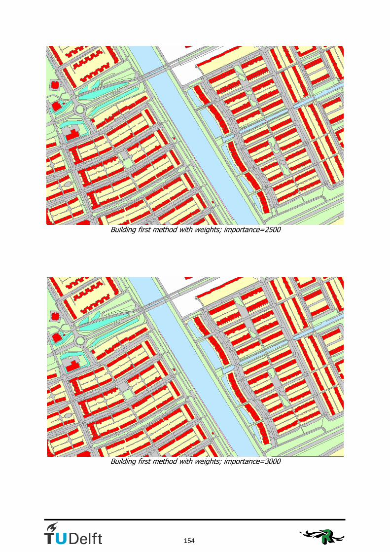
154
Building first method with weights; importance=2500
Building first method with weights; importance=3000

155
Building first method with weights; importance=3500
Building first method with weights; importance=3805

156
Appendix I: Visualisation of the trials to improve the values for weights and compatibilities
This appendix shows the iteration steps that were done to come to good values for the weights and comaptibilties for the test dataset as mentioned in section 6.1. Starting point of this iteration was the end result of chapter 5.
Visualisation of the end result using the building first method with weights.
Result after trial 1

157
Result after trial 2
Result after trial 3

158
Result after trial 4
Result after trial 5
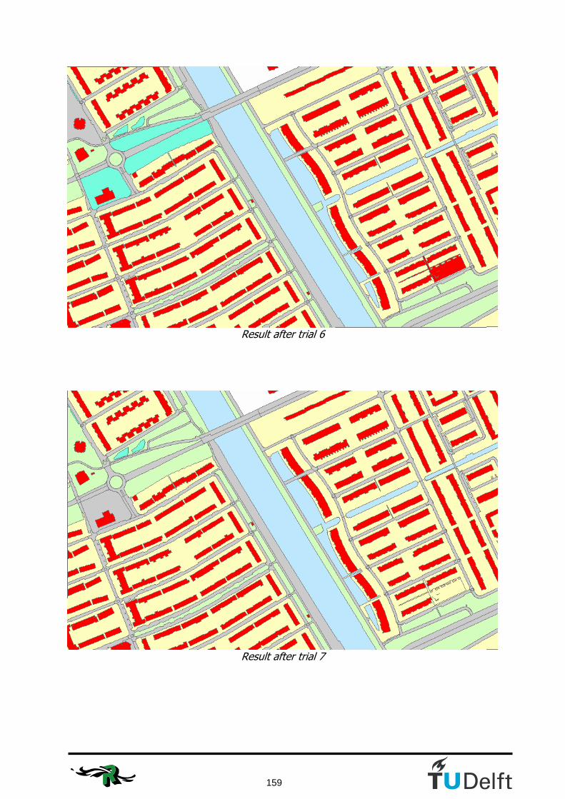
159
Result after trial 6
Result after trial 7
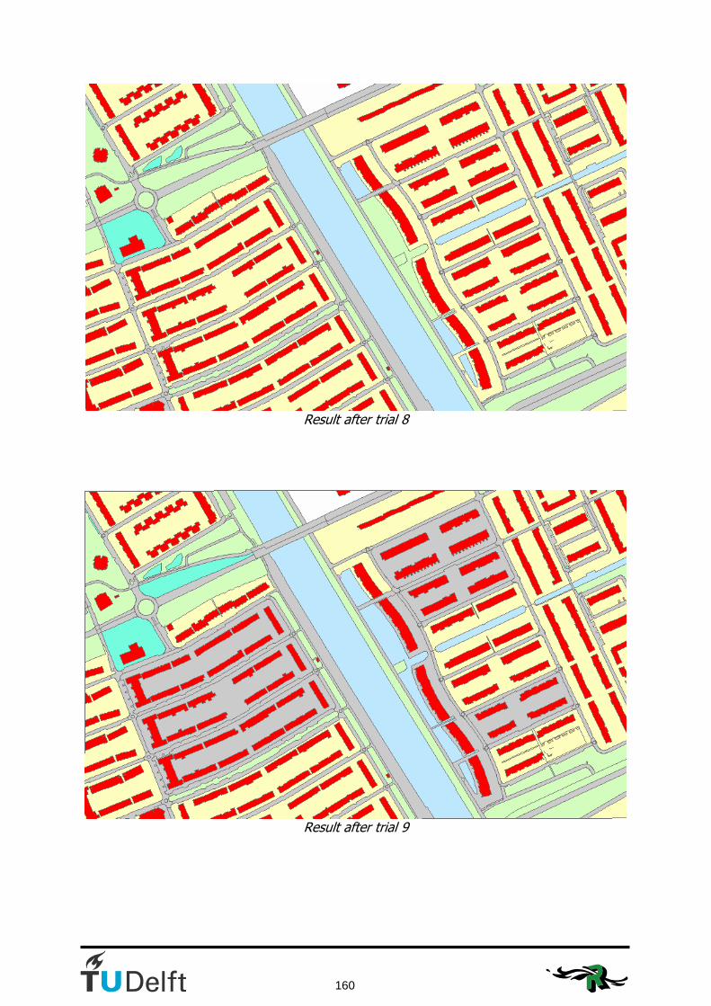
160
Result after trial 8
Result after trial 9

161
Result after trial 10
Result after trial 11

162
Result after trial 12
Result after trial 13

163
Result after trial 14
Result after trial 15

164
Final result after trial 16

165
Appendix J: Visualisation of the tGAP without constraint
This appendix shows the visualisation of the steps of the test data in the tGAP structure without constraint. This means that IMGeo objects might even be merged with objects outside their preciously defined region. This is done to see whether a constraint is really necessary. The tGAP is visualised until there is only one object left, here we can see that the ‘edge-remover’ in the tGAP-code didn’t work properly all the time.
tGAP without constraint; importance=500

166
tGAP without constraint; importance=1000
tGAP without constraint; importance=1500

167
tGAP without constraint; importance=2000
tGAP without constraint; importance=2500
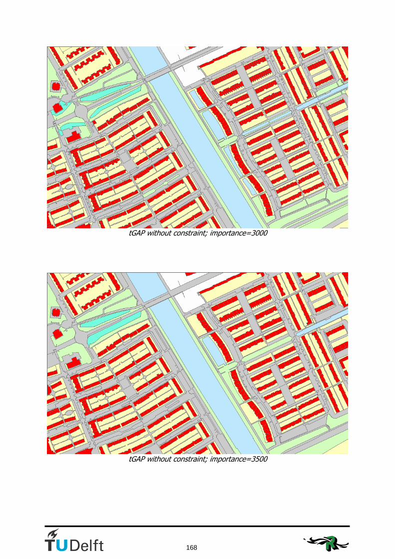
168
tGAP without constraint; importance=3000
tGAP without constraint; importance=3500
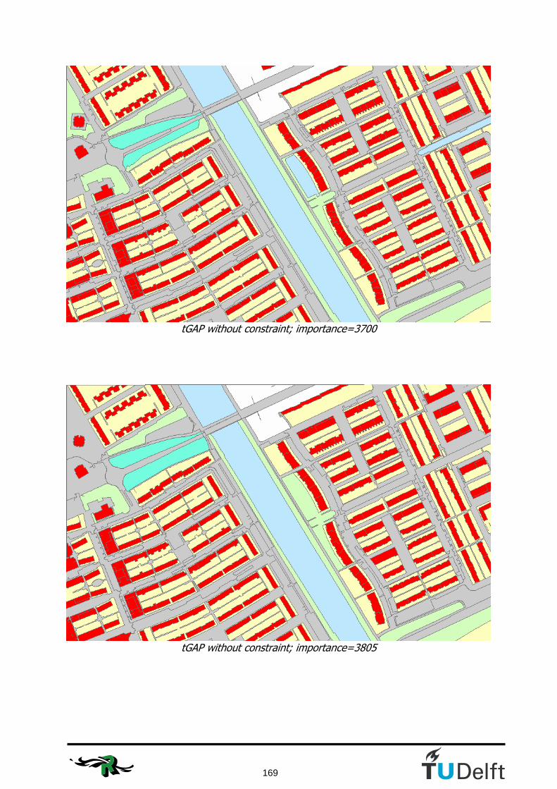
169
tGAP without constraint; importance=3700
tGAP without constraint; importance=3805

170
tGAP without constraint; importance=3900
tGAP without constraint; importance=4000
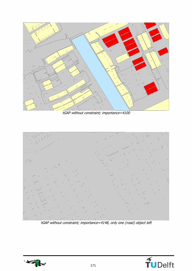
171
tGAP without constraint; importance=4100
tGAP without constraint; importance=4148, only one (road) object left

172
Appendix K: Visualisation of the constrained tGAP methods for the large dataset
This appendix shows the visualisation in steps of the large dataset. Starting at importance level 0 (the original IMGeo file) to the end restult after 24482 merges.

Visualisation of the large dataset; importance=0

Visualisation of the large dataset; importance=4000
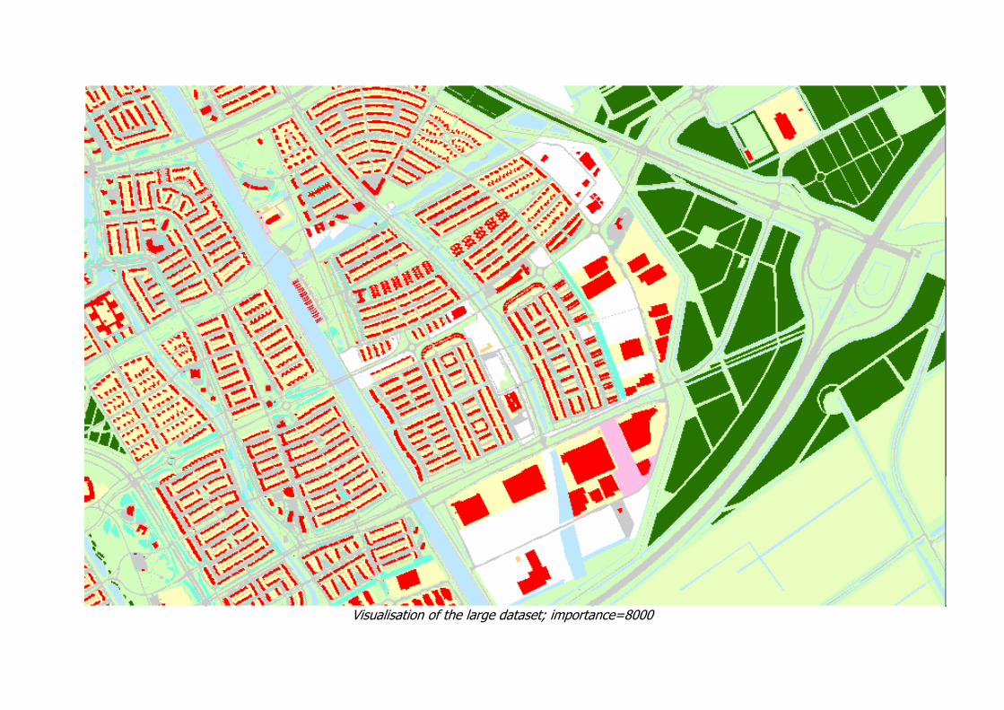
Visualisation of the large dataset; importance=8000

Visualisation of the large dataset; importance=12000

Visualisation of the large dataset; importance=16000
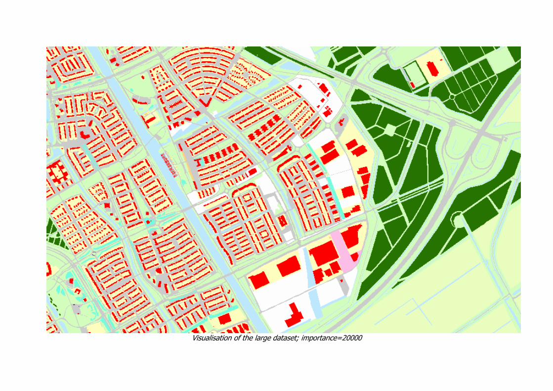
Visualisation of the large dataset; importance=20000

Visualisation of the large dataset; importance=24482