designing the edge report
TRANSCRIPT

Designing the Edge Creating a Living Urban Shore at Harlem River Park
Artists, engineer, landscape architect, planner and biologist inspect preconstruction conditions of Harlem River Park at 135th Street.
METROPOLITAN WATERFRONT ALLIANCE
A project of the Municipal Art Society Harlem River Park Task Force NYC Parks&Recreation
NYS DOS, Division of Coastal Resources
Report Designing the Edge is a collaborative project with a new approach to the way an urban park meets the water’s edge. While the primary intent for seawalls has traditionally been to keep land from eroding into the water, the Designing the Edge approach engages interdisciplinary and participatory design to create waterfront edges that achieve multiple goals: in-water recreation, flood storage, access to the water, shoreline habitat and reduced pollution from storm water. Harlem River Park is presented as a demonstration, illustrating several ways to design porous, living city shorelines.

1
Designing the Edge, 2010NYC Parks & Recreation and Metropolitan Waterfront Alliance
CreditsThis report was prepared for the New York State Department of State
with funds provided under Title 11 of the Environmental Protection Fund.February, 2010
Project Partners:New York City Department of Parks & Recreation
Metropolitan Waterfront Alliance Harlem River Park Task Force
New York State Department of State, Division of Coastal Resources
Special thanks for donating marine engineering and technical support:
Stevens Institute Center for Marine Studies
Executive Acknowledgements
Honorable Michael R. Bloomberg, Mayor, City of New YorkHonorable David Paterson, Governor, State of New York
Adrian Benepe, Commissioner, City of New York Parks & RecreationAmy Freitag and Therese Braddick, Deputy Commissioners, Parks & Recreation Capital Projects
Municipal Arts Society Manhattan Community Boards 10 and 11
Harlem Community Development Corporation
Primary Author Marcha Johnson, PhD ASLA, Designing the Edge Project Leader, New York City Parks & Recreation
Key ParticipantsNYC Parks: Jennifer Hoppa, Deputy Director of Planning, Ricardo Hinkle ASLA Landscape Architect,
Reza Mashayekhi, Engineer, Brian Thompson, Grants Administrator, Dewberry Engineers- Phase 2
Metropolitan Waterfront Alliance: Carter Craft, Executive Director, Porter-Ann Gaines and Neal Kroner Harlem R. Park Task Force: Thomas Lunke, Director, Richard Toussaint, Master Plan Concept
NYS Dept. of State Coastal Resources: Fred Landa and Nancy Welsh, Coastal Resources Specialists, Curtis CravensStevens Institute Center for Marine Studies: Dr. Thomas Herrington, Dr. Raju Datla
The Webb Institute: Richard Royce, Wave Tank Model TestingNYC Economic Development Corporation: Daniel Zarrilli, Assistant Vice President
Parsons Brinkerhoff Quade and Douglas- Phase 3

2
Designing the Edge, 2010NYC Parks & Recreation and Metropolitan Waterfront Alliance
Credits ContinuedBrainstorming Session Consultants:
Terry Boddie, ArtistJackie Brookner, Artist
Michael Fishman, ArchitectDr. Thomas Herrington, Marine Engineer, Stevens InstituteDr. Michael Judge, Marine Biologist, Manhattan College
Michael Lee Poy, Artist
Video film documentation:Keith Rodan, Greenpoint Video Project
Model designer/builder:Umit Koroglu
Harlem River Park Location not to scale
Designing the Edge Work-shop Sign-in SheetOctober 2nd, 2004:
Naomi LangleyJudith ManningLisa LittlejohnCatherine BrownElaine ParkleAlfred C. PalteroEliza StricklandJennifer Hoppa Justin BloomChris WilliamsAlice LaBrieHannah BrockingtonFlorence MiddletonDaniel PerezTom LunkeVirginia MontagBarbara JohnsonJohn T. ReddickRichard ToussaintKaren PhillipsJ.P. MagronAlice Blank
Harlem River Park 132nd to 145th St.

3
Designing the Edge, 2010NYC Parks & Recreation and Metropolitan Waterfront Alliance
Table of Contents
Executive Summary p.4
PART ONE WHAT IS WRONg WITH THE STANDARD ESPlANADE? p. 8Criteria for success p. 9Context p.9
PART TWO TRYINg A DIFFERENT APPROACH p.10Research questions and objectives p.10Method p. 11Harlem River Park site conditions p.16
PART THREE gATHERINg IDEAS p.17Master Plan p. 17Community workshop p. 18Workshop outcomes p. 22The “architecture” of shoreline organisms p. 24
PART FOUR SPECIFIC SITE SOlUTIONS p. 27Alternative approaches p.28Criteria for evaluation p.31 Wave tank test results, conclusions p. 36Cost comparison p. 37
PART FIVE CONClUSIONS p. 39
Appendixes1. Transcript of workshop comments p. 402. Final design details p. 453. Gabion report excerpt, US Army Corps of Engineers p. 495. References p.51
Model of the “crust”of filter-feeding marine organisms on a wooden piling, at American Museum of Natural History

4
Designing the Edge, 2010NYC Parks & Recreation and Metropolitan Waterfront Alliance
Executive SummaryThe New York City Department of Parks & Recreation, the Metropolitan Waterfront Alliance (MWA), and the Harlem River Park Task Force collaborated on a project to replace degraded steel walls along the river with something dramatically different, with more habitat value, which allows recreational use of the water. The “Designing the Edge” project, funded in part by New York State Department of State Division of Coastal Resources, is an effort to provide alternatives to industrial-era steel bulkheads. A $40,000 grant allowed the design team more time to brainstorm with an unusual combination of scientists and artists, and extend community involvement to inform and redirect what would otherwise have been a standard city park and esplanade with a vertical seawall separating park use from the river.
The objective was to generate a range of ideas and solutions that could improve the ecological and recreational benefits of urban edges in general, and to select appropriate features specifically for Harlem River Park. The aim for the Harlem River site is a stable shoreline that improves near-shore fish habitat, makes the waterfront edge more compatible with recreational use and creates safe public access to the water. A landscape architect, planner, marine engineer, marine biologist, and envi-ronmental artists, joined with MWA, the Harlem River Park Task Force, community members, other interested citizens and professionals to develop a series of ideas specific to the Harlem River con-ditions. Along with input from Community Boards 10 and 11, elected officials, tenant groups and other residents of East Harlem, the Parks design team developed a range of solutions based on many of the ideas, issues and concerns raised at the workshop. Plastic models of three prototypes of po-rous shorelines were tested in a wave tank, so that the effect of the shoreline shape and alignment on water flow and velocity could be analyzed. The results influenced the final design.
Phase Two (by NYC Parks for $7.3 million) and Phase Three (by NYC EDC for $7 million) of Harlem River Park were constructed in 2007- 2009. The park presents an ideal location to compare durability, amenities and habitat value of the traditional steel sheetpile wall in Phase One with shell and rock-filled gabions and tidepools in Phase Two, and planted “Greenwall” structures in Phase Three. Some of the expectations for the two new phases are:1. More people using the park to get close to the river 2. People discovering estuarine life among the rocks, tidepools and plants3. Water velocity which is noticably diminished along the shore4. Estuarine plants and animals colonizing the various porous surfaces, filtering the water for nutri-
ents and taking out pollutants at the same time and 5. Boaters taking advantage of new opportunities to visit the park from a more accessible edge.
The following ten principles summarize ideas for achieving these goals.
Elevation Design for Phase 2, Harlem R. Park
5
Designing the Edge, 2010NYC Parks & Recreation and Metropolitan Waterfront Alliance
Ten Principles for Creating a Living Edge
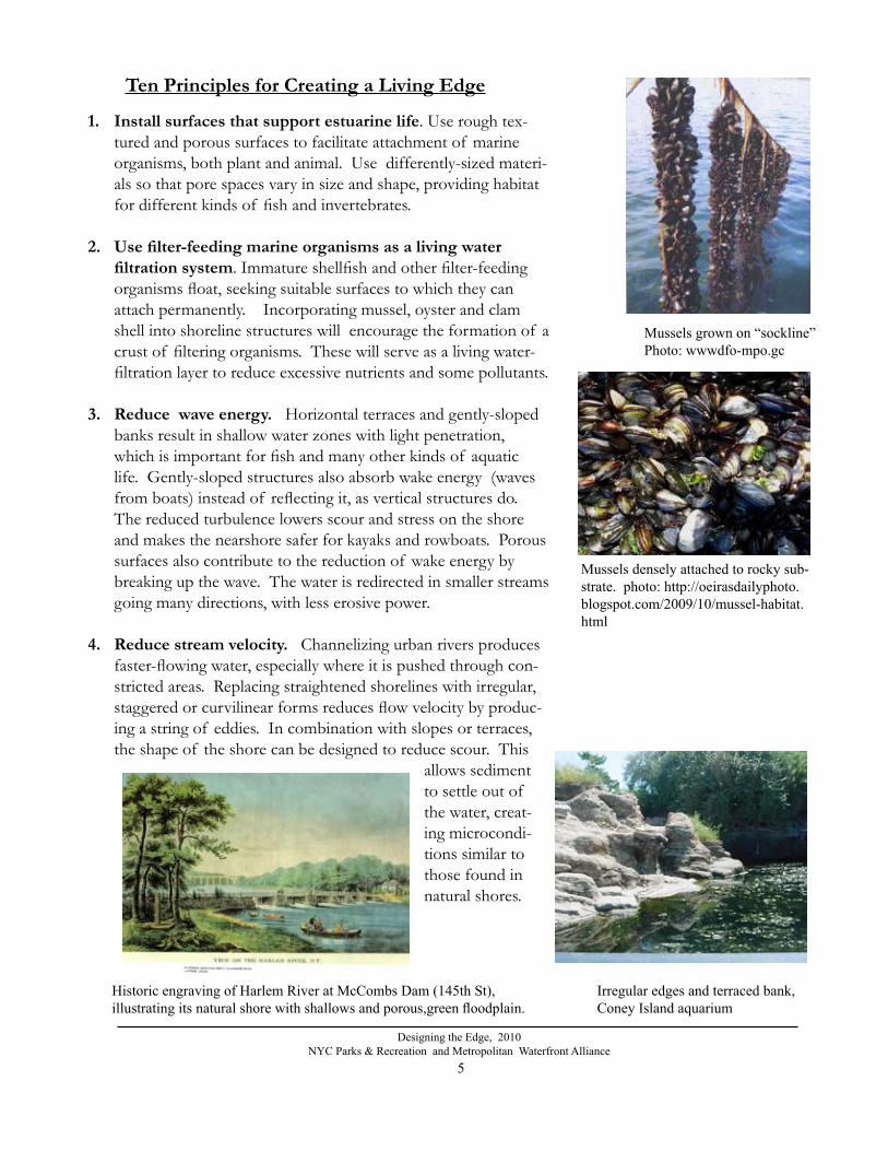
1. Install surfaces that support estuarine life. Use rough tex-tured and porous surfaces to facilitate attachment of marine organisms, both plant and animal. Use differently-sized materi-als so that pore spaces vary in size and shape, providing habitat for different kinds of fish and invertebrates.
2. Usefilter-feedingmarineorganismsasalivingwaterfiltrationsystem. Immature shellfish and other filter-feeding
organisms float, seeking suitable surfaces to which they can attach permanently. Incorporating mussel, oyster and clam shell into shoreline structures will encourage the formation of a crust of filtering organisms. These will serve as a living water-filtration layer to reduce excessive nutrients and some pollutants.
3. Reducewaveenergy. Horizontal terraces and gently-sloped banks result in shallow water zones with light penetration, which is important for fish and many other kinds of aquatic life. Gently-sloped structures also absorb wake energy (waves from boats) instead of reflecting it, as vertical structures do. The reduced turbulence lowers scour and stress on the shore and makes the nearshore safer for kayaks and rowboats. Porous surfaces also contribute to the reduction of wake energy by breaking up the wave. The water is redirected in smaller streams going many directions, with less erosive power.
4. Reducestreamvelocity.Channelizing urban rivers produces faster-flowing water, especially where it is pushed through con-stricted areas. Replacing straightened shorelines with irregular, staggered or curvilinear forms reduces flow velocity by produc-ing a string of eddies. In combination with slopes or terraces, the shape of the shore can be designed to reduce scour. This
allows sediment to settle out of the water, creat-ing microcondi-tions similar to those found in natural shores.
Historic engraving of Harlem River at McCombs Dam (145th St),illustrating its natural shore with shallows and porous,green floodplain.
Mussels densely attached to rocky sub-strate. photo: http://oeirasdailyphoto.blogspot.com/2009/10/mussel-habitat.html
Irregular edges and terraced bank,Coney Island aquarium
Mussels grown on “sockline” Photo: wwwdfo-mpo.gc

6
Designing the Edge, 2010NYC Parks & Recreation and Metropolitan Waterfront Alliance
5. Emphasizenativeplants. Shoreline structures planted with native species create an urban variation of a stream buffer zone: much greener, sweeter smelling and better looking than their industrial-era counterparts. These can include porous walls with terraces for plants, greenwalls with voids that can hold soil and plants, and several other types of vegetated walls. Connecting fragmented habitat patches with a green corridor can greatly increase the ecological value of marginal and disturbed habitats. These linear green spaces support wildlife in many ways, includ-ing food and nesting materials, and cover that allows wildlife populations to move along the stream corridor and reach other types of ecosystems necessary at different points in their life cycle (for example marine turtles might seek a sandy patch for nesting). Varying heights of vegetation supports a larger variety of species, including those which seasonally use different canopy levels. Planted slopes resist erosion with a network of roots.
6. Usebioremediation. Everyday dust, litter, oil droplets and other urban contaminants run off the pavement with every rainstorm and ends up in rivers and lakes. Earthen banks, along with vegetated space, allow this polluted runoff to percolate through layers of roots, soil and rock, where microorganism activity cleanses the water on its way into the river. Where pos-sible, paved areas should be minimized and replaced with porous surfaces, including organic material to support helpful bacteria.
7. Employmaterialswhicharedurableinurbantidal conditions: Choose materials which are durable, especially
against salt corrosion, vandalism, wake action, ice scour and freeze/thaw expansion and contact with boats. Marine-grade plastics, salt-resistant concrete, recycled rubber tires and stone are particularly long-lasting materials.
Breakwater of recycled tires. Image credit: US Army Corps of Eng. Low Cost Shore Protection, 1981.
Gabion planted with willow stakesCredit: Land and Water, Vol. 49 No.1, Jan, 2005
“Evergreen”Greenwall, near Athens, NY. Photo: LI Precast
Harlem River Park looking north from 140th St. after construction by EDC, 2009
7
Designing the Edge, 2010NYC Parks & Recreation and Metropolitan Waterfront Alliance
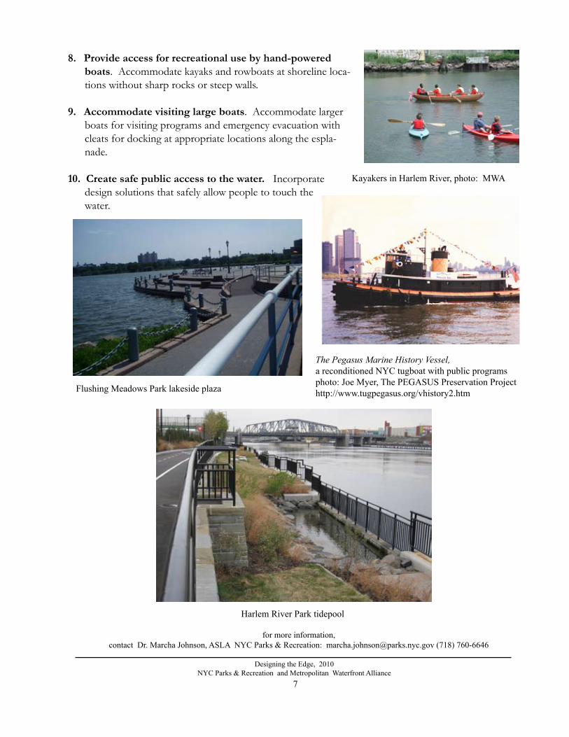
8. Provideaccessforrecreationalusebyhand-poweredboats. Accommodate kayaks and rowboats at shoreline loca-tions without sharp rocks or steep walls.
9. Accommodatevisitinglargeboats. Accommodate larger boats for visiting programs and emergency evacuation with cleats for docking at appropriate locations along the espla-nade.
10.Createsafepublicaccesstothewater. Incorporate design solutions that safely allow people to touch the water.
Kayakers in Harlem River, photo: MWA
The Pegasus Marine History Vessel, a reconditioned NYC tugboat with public programsphoto: Joe Myer, The PEGASUS Preservation Projecthttp://www.tugpegasus.org/vhistory2.htmFlushing Meadows Park lakeside plaza
Harlem River Park tidepool
for more information, contact Dr. Marcha Johnson, ASLA NYC Parks & Recreation: [email protected] (718) 760-6646
8
Designing the Edge, 2010NYC Parks & Recreation and Metropolitan Waterfront Alliance
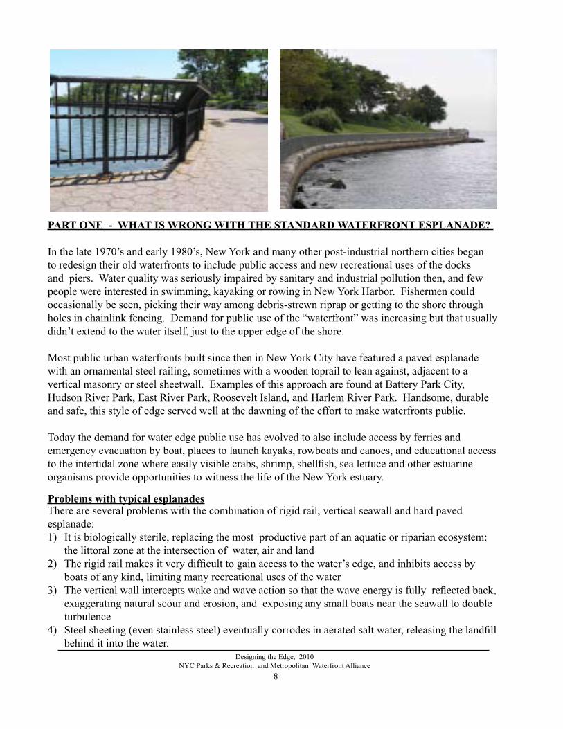
PART ONE - WHAT IS WRONg WITH THE STANDARD WATERFRONT ESPlANADE?
In the late 1970’s and early 1980’s, New York and many other post-industrial northern cities began to redesign their old waterfronts to include public access and new recreational uses of the docks and piers. Water quality was seriously impaired by sanitary and industrial pollution then, and few people were interested in swimming, kayaking or rowing in New York Harbor. Fishermen could occasionally be seen, picking their way among debris-strewn riprap or getting to the shore through holes in chainlink fencing. Demand for public use of the “waterfront” was increasing but that usually didn’t extend to the water itself, just to the upper edge of the shore. Most public urban waterfronts built since then in New York City have featured a paved esplanade with an ornamental steel railing, sometimes with a wooden toprail to lean against, adjacent to a vertical masonry or steel sheetwall. Examples of this approach are found at Battery Park City, Hudson River Park, East River Park, Roosevelt Island, and Harlem River Park. Handsome, durable and safe, this style of edge served well at the dawning of the effort to make waterfronts public.
Today the demand for water edge public use has evolved to also include access by ferries and emergency evacuation by boat, places to launch kayaks, rowboats and canoes, and educational access to the intertidal zone where easily visible crabs, shrimp, shellfish, sea lettuce and other estuarine organisms provide opportunities to witness the life of the New York estuary.
There are several problems with the combination of rigid rail, vertical seawall and hard paved esplanade:1) It is biologically sterile, replacing the most productive part of an aquatic or riparian ecosystem:
the littoral zone at the intersection of water, air and land2) The rigid rail makes it very difficult to gain access to the water’s edge, and inhibits access by
boats of any kind, limiting many recreational uses of the water3) The vertical wall intercepts wake and wave action so that the wave energy is fully reflected back,
exaggerating natural scour and erosion, and exposing any small boats near the seawall to double turbulence
4) Steel sheeting (even stainless steel) eventually corrodes in aerated salt water, releasing the landfill behind it into the water.
Problems with typical esplanades

9
Designing the Edge, 2010NYC Parks & Recreation and Metropolitan Waterfront Alliance
Context: Increasingly Hardened EdgesHistorically in the United States, urban frontage on water bodies such as the Harlem River was used for transporting goods, manufacturing materials that needed to be shipped by water and a variety of commercial enterprises dependent upon water resources. Most of these activities required modi-fications to the natural shoreline to get large, deep-drafted ships close to the shore for loading and unloading. Landfills held by seawalls, wooden piers, relieving platforms, docks, slips and wharves characterized the waterfront of the industrial era. In New York’s early development, fragments of wetlands, naturally forested banks and naturally irregular shoreline were left in between pockets of developed shore. Eventually much of the city’s river banks were hardened with rock (rip rap) to control erosion of steeply engineered slopes.
5) There is no capacity for flood storage, an increasingly serious problem in the region, as sea levels rise and paved urban surfaces exacerbate the “flash flood” potential of heavy rainstorms.
6) Waterside wildlife corridors, typical along natural water bodies and vital to the movement of wildlife through the urban environment, are largely eliminated when no vegetation can grow on the bank’s armored surface.
The ideas explored here resulted in a physical prototype which may be applicable to waterfronts in other locations, and a range of future possibilities not yet constructed.
Criteria for SuccessThe following criteria were applied to the design for Harlem River Park’s new edge :- prevent upland park landfill from slumping or eroding - provide a system that is cost-competitive with traditional sheet pile bulkheading- provide space for the specific park program, especially a multi-use waterfront pathway- replace some of the valuable ecological functions of a river bank, especially a porous interface between aquatic and upland environments- provide buffer and primary habitat for intertidal plants, finfish and filter feeding shell fish.
Hardened waterfront edges: seawalls or riprap
On rivers in other cities where seasonal flooding threatens urban development such as along the Seine River in France and in New Orleans along the Mississippi, floodwalls, dikes and levees historically contained the high water. Contemporary flood control technology includes massive tidegates with architectural structures, as seen in London, Rotterdam and Venice. As a consequence of the variety and ubiquity of hardened edges, a common image of “urban riverfront” is a mostly-paved area dominated by human-built structures with little value to fish or wildlife. In fact, designers and engineers, as well as members of the public, often express surprise when they witness
Typical naturalizing rip rap shore, Bronx NY

10
Designing the Edge, 2010NYC Parks & Recreation and Metropolitan Waterfront Alliance
Ironically, most of the dock areas formerly used for shipping are now dysfunctional for ships, since the searails make it difficult to arrive by ferry or larger boats. Most of the new waterfront esplanades cannot be used to launch a kayak. Urban rivers in many cultures have religious roles in addition to commercial and recreational ones. Ritual baths, funerals and other ceremonies in-volving many thousands of participants are accommodated by structures such as water stairs. Such stairs in an intertidal zone or floodplain become colonized by algae, which can be slippery. Grooved, pitted and roughened surfaces and handrails help reduce the risk of slipping. In New York, a combination of factors converge to make it very difficult for the public to actually come in contact with harbor waters. While there are great sweeps of beach in the outer boroughs, there are very few points of natural water contact along densely developed neighborhoods. Fear of inadvertently putting people, especially small children, and dogs in danger of being swept away by rapidly flowing, deep water along the bulkhead walls resulted in stout railings that prevent any contact with the water. Even piers which formerly had ladders into the water and low rails or none at all to facilitate shipping, now are ringed with 4’ fences when they are open to the public.
life in New York waters. The waters of the Hudson R. estuary supported extensive oyster reefs along with saltmarshes and a
complex, healthy, diverse ecosystem prior to development. The estuary became degraded over two centuries of urban-ization. Through environmental action starting in the 1970’s and increasing public awareness, harbor pollution has been controlled. Some water pollutants in New York have been greatly reduced. There are indications of improving condi-tions and an ecosystem being gradually repaired: oysters and striped bass are increasing and oxygen levels are up. Other indicator species though, including wading birds, perch, shad and eels are in decline, along with recent wetland losses.
Hudson R. Striped Bass, photo: www.dec.ny.gov/animals/9962.html
a live fish in urban waters, having almost no awareness of the river’s living organisms.
Demand for Small Boat Access A considerable proportion of America’s shipping economy gave way to land and air freight, and service-based economies in the late Twentieth Century. Post-industrial cities like New York are converting some of the relics of the shipping and transportation infrastructure to recreational uses. Simultaneously, cleaner water and the return of fisheries have focused new public attention on use of the harbor for kayaking, rowing, fishing, swimming and other recreational contact with the water.
A public waterfront without searailsOriental Bay, Wellington, New Zealand photo and design: Isthmus Landscape Architects
ORIENTAL BAY URBAN FORESHORE , WELLINGTON, NZDesigned in association with ARCHITECTURE WORKSHOP and TONKIN&TAYLORCLIENT: Wellington City Council CLIENT CONTACT: Bruce GeddenBUDGET: $7 million (New Zealand dollars)TIME FRAME: 2001 - 2004AREA: 1km of coastlineAWARDS: 2005 Ministry for the Environment Year of the Built Environment Premier Award; 2005 International Federation of Landscape Architects’ (IFLA) Eastern Region Excellence Award; 2005 Wellington Civic Trust The Wellington Civic Trust Award; 2005 Association of Consulting Engineers (ACENZ) Innovative New Zealand Gold Award; 2004 New Zealand Recreation Association’s Outstanding Project Award; 2004 New Zealand Institute of Landscape Architects (NZILA).George Malcolm Supreme Award for outstanding contribution to Landscape Architecture; NZIA Supreme Award for Architecture; and NZIA Regional Award for Architecture.
ORIENTAL BAY WELL INGTON
URBAN DESIGN

11
Designing the Edge, 2010NYC Parks & Recreation and Metropolitan Waterfront Alliance
Addressing Fragmentation. Establishing green corridors along built up shorelines can sometimes reconnect habitat complexes which were separated by human construction. Such corridors help mitigate the impacts of habitat fragmentation on wetland, upland and aquatic species. Connectivity efforts can also be combined with restoring some of the physical functions of natural shores such as absorbing wave energy, stor-ing floodwaters, providing a variety of substrates for spawning grounds, and differently-sized shel-tered voids for swimming animals of various sizes. By using structures that enable plants to spread and animals to move from one part of the shore to another such as greenwalls, a constructed water-front can help maintain ecosystem functions of the river bank.
Site conditions at Harlem River ParkThe Harlem River is a tidal estuary connecting two other tidal waters: the Hudson and the East Riv-ers. Two bridges cross the river in the project area, at Madison Ave/138th St. and 145th St. De-velopment as a shipping channel bounded by highways was complete by the 1940’s, establishing today’s shoreline conditions. Between 139th and 145th Streets, the river’s earthen banks were hard-ened with a variety of bulkheads and revetments, and narrowed with landfill on the Manhattan side by approximately 1000 feet. The channel was deepened and straightened for commercial shipping.
Separated from inland neighborhoods by Harlem River Drive, the project site is a narrow strip of undeveloped park land along the bulkhead. Pedestrians access the site from Manhattan via a walk along the highway access ramp at 139th, and from the Bronx via the Madison Ave. bridge ramp. The Phase 2 site is 2000 feet long, with developable park space varying from a width of about 10’ along rip rap to a width of 105 feet, including a ramped walkway and green space. Relatively level ground inside the bulkhead is vegetated by grassy meadow and volunteer trees and shrubs typical of urban coastal areas. Steep rip rap occupies 490 linear feet of the shoreline just north of the Madison St. bridge. Extensive corrosion of the steel sheetpile bulkhead and water seepage below the wall have left large voids in the landfill behind the bulkhead, and clearly unstable surfaces along much of the site. The section between 142nd and 145th Streets is closed to the public for this reason.
Views up and down the Harlem River are dramatic, and while commercial use has declined, recre-ational river traffic is increasing. South of the project site, Harlem River Park Phase 1 is a recently constructed park with seating, a playground, bikeway/greenway, colorful plantings and a new sea-wall with railing. Phase 1 provides no public access to the water. Long-term plans for the west bank of the Harlem River include a continuous park, bicycle path and greenway from the Triborough Bridge to the new Peter Sharp Boathouse at Swindler’s Cove in the nothern reach of the river.
View South from E.140th View SW from about 137th St View E. under Harlem R. Dr. ramp

PART TWO : TRYINg A DIFFERENT APPROACH
“Designing the Edge” is an interagency cooperative effort to imagine alternatives to the industrial bulkheads lining the NYC waterfront and constraining its use for recreation, environmental improve-ment and public access.
The research questionsWhat products and approaches can replace the vertical, biologically hostile environment of steel sheeting and still hold back landfill and function to support upland recreational park uses? Are there physically and economically feasible substitutes for sheet piles that are flexible and porous, stable enough for safety but which also allow soil organisms to bioremediate urban runoff, support riparian habitat, encourage attachment of filter feeding shellfish and algae to clean the water?
How can the urban shoreline actively contribute to the cleansing of groundwater and river water, as well as habitat for native plants and animals?
Of a variety of alternative forms (both horizontal and vertical), which can be demonstrated through testing to be best at dissipating wake/wave energy, slowing current velocity and facilitating sediment accumulation along the littoral zone? Can flexible, porous materials, terraces and sloped structures do the job of a steel sheetwall?
Objectives
The objectives were to: - accommodate safe public access to the water’s edge- provide access to the park for people arriving by hand-powered boats, including docking space
for visiting boats such as those with educational programs or evacuation via boat in case of an emergency - use structures that absorb and dissipate wake energy, such as porous, sloped or terraced embankments- use porous ground surfaces and plantings to filter surface runoff - make use of healthy soil bacteria to improve groundwater (bioremediation)- include cultural/historical references and public art
Jackie Brookner, Naomi Langley and workshop participants, October 2004.
Designing the Edge, 2009NYC Parks & Recreation and Metropolitan Waterfront Alliance
12

Method
a. Attaching the research to a capital project with construction fundingAn unusual aspect of this grant supporting research and idea-generating was that it was attached to a funded capital project, ensuring that at least some of the ideas would be constructed right away. The intent of this project was to determine the most appropriate methods for reconstructing the de-graded seawall and infrastructure along the Harlem River, after exploring economical and multiple-purposed waterfront edge designs. b. Invite new voices and perspectives into the Park design processIn order to explore non-traditional structures and help bring new thinking to the design effort of creating an urban riverbank, it was decided early in the process to invite participation from people not typically involved in park design. Six short-term contracts, essentially a weekend or so of brain-storming and discussion with community leaders were established with the following:
1) Terry Boddie, an artist who combines photographic imagery with African pictographic forms, soil, maps and leaves on subjects related to the African Diaspora.
2) Jackie Brookner, a sculptor who works with flowing water, plants, stone and earth to build “Biosculptures,” which cleanse stormwater through bioremediation.
3) Michael Fishman, an architect who plans urban infrastructure focused on improving the health of the built, natural and social environments.
4) Dr. Thomas Herrington, Professor of Ocean Engineering at Stevens Institute of Technology, Center for Maritime Systems, and a Sea Grant Coastal Processes Specialist, with research in wave mechanics, fluid measurements and the interaction of shoreline structures with currents and waves.
5) Dr. Michael Judge, Professor of Biology at Manhattan College, who teaches estuarine ecology and studies the effects of water flow on marine benthic invertebrates, the role of habitat cues on fiddler crabs and environmental toxicology of metals in sediments.
6) Michael Lee Poy, an artist also trained as an architect, with a particular interest in Caribbean cultures, who explores the multi-dimensional meanings of “home” in his work.
With the support of the Stevens Institute and assistance from Professor Richard Royce at the Webb Institute for Naval Architecture and Marine Engineering, Dr. Herrington’s role greatly expanded to include testing of physical models in a wave tank. This series of tests simulated the flow of water in the Harlem R. shore interacting with four different types of sea wall structures: a vertical sheetwall, a greenwall, a rectilinear gabion wall with tide pool and a serpentine, sloped wall of round tire gabions. This made it possible to compare a traditional steel sheetwall with porous alternatives.
Partners Four key agencies partnered in developing the method and achieving results under the Designing
Designing the Edge, 2009NYC Parks & Recreation and Metropolitan Waterfront Alliance
13

14
Designing the Edge, 2010NYC Parks & Recreation and Metropolitan Waterfront Alliance
1) NYC Parks & Recreation is the city agency responsible for acquiring the land, planning the development, design and construction, and long-term programming and maintenance of Harlem River Park. In 2005, NYC Parks had $2.5 million for design and construction of Phase 2 of Hudson R. Park in the FY06 construction budget. NYC Parks’ Planning and Capital Projects staff led the project.
2) The NY State Department of State Division of Coastal Resources funded the project’s research and outreach component with a $40,000 grant. They also guided basic decisions about how to ap-proach the issues with a multi-disciplinary and community-based structure. The NY State Depart-ment of Environmental Conservation also met early on with the design team and encouraged the direction toward a porous, flexible shoreline cut back from the bulkhead line.
3) The Metropolitan Waterfront Alliance is a non-profit network of organizations and concernedindividuals dedicated to helping the NYC region reclaim and reconnect to the harbor, rivers andestuaries of the New York and New Jersey waterfront. The Metropolitan Waterfront Alliance worksthrough education, grassroots organizing and media advocacy to include the public’s voice andvalues in the decision-making that will determine the future of our region’s waterfront and waterways. When the Alliance approached NYC Parks about collaborating on an innovativewaterfront design, the agency agreed to try to apply the ideas generated if they fit into the budget and time frame for construction.
4) The Harlem River Park Task Force is a community-based advocacy group formed in 2001. It is comprised of a growing number of city and regional organizations and elected officials. It initiated the planning for Harlem River Park, including a master plan designed by Richard Toussaint, which the Parks Department largely adopted in spirit, if not every detail. The Task Force has been instrumental in generating support for the whole park and was key in reviewing the portion included in Designing the Edge.
Its members include: Manhattan Borough President C. Virginia Fields Assemblyman Keith L.T. WrightCouncilman Bill PerkinsCouncilman Philip ReedCongressman Charles B. RangelManhattan Community Board 10Manhattan Community Board 11369th Regiment ArmoryCIVITASCommunity Association of East Harlem TriangleLenox Terrace Association of Concerned TenantsAbraham Lincoln Houses Tenant AssociationNew Yorkers for ParksNew York Restoration Project The Urban Divers Estuary ConservancyUrban GreenRobert Wagner Houses Tenant AssociationWaterfront Park Coalition
Preconstruction condition near 145th,showing collapsed esplanade.

15
Designing the Edge, 2010NYC Parks & Recreation and Metropolitan Waterfront Alliance
East Harlem Business Capital CorporationEsplanade Gardens Tenants AssociationRiverton Tenants Association Genesis Community Development CorporationHarlem Community Development CorporationMetropolitan Waterfront AllianceNew York League of Conservation VotersRiverbend Housing Company, Inc.RiverkeeperWest Harlem Environmental Action
5. Economic Development Corp. About midway through the project, the NYC Economic Develop-ment Corporation assumed a major role in fulfilling the vision established through the Designing the Edge project. EDC’s job is to support and promote business in the city. In the 1990’s, EDC be-came the owner of large parcels of waterfront property during the restructuring of city government. Through an agreement with NYC Parks, EDC is currently responsible for repairing the northern-most section of the park. That section, between 139th St. and 145th Street, was constructed as a traditional upland park in the 1990’s. It was believed at the time that the seawall was intact, since the corrosion was concentrated just below the mean low water and seldom seen. The pave-ments along the seawall edge collapsed and subsided soon after construction was complete due to loss of fill through the holes in the rapidly corroding walk. Trees and park furniture slipped into the gaping sinkholes, and the area was fenced to protect the public. In 2005, EDC agreed to extend the more porous, greener, access-oriented approach to their site. EDC’s consultant, Parsons Brinker-hoff worked together with NYC Parks and EDC to ensure as seamless a transition as possible from Phase 2 to Phase 3. Upon satisfactory completion of the EDC construction, the Parks Department assumed responsibility for that section of the park in 2009. Selecting a Site
Carter Craft of Metropolitan Waterfront Alliance and Marcha Johnson of NYC Parks first discussed collaborating to design greener water edges with multiple functions in 2001. When the MetropolitanWaterfront Alliance approached NYC Parks & Recreation about influencing a capital park projectwith inspiration from a research and brainstorming process, there was no particular location in mind.Under the direction of David Carlson, then Director of Landscape Architecture, and Jennifer Hoppa, Dep. Director of Planning, several waterfront parks funded in FY 05 were considered.
Criteria for selecting a site included :a) a park with a decaying shoreline that needed reconstruction;b) public visibility, since it was intended that the project have the potential to influence other water-front designs;c) a project which was “ready” to go, with surveys and enough information and funding to start immediately;d) a phased project with a short piece where something new could be tried on a small scale; and e) a park which already had dedicated community activists interested in working with us to reach out to the larger neighborhood.

16
Designing the Edge, 2010NYC Parks & Recreation and Metropolitan Waterfront Alliance
Harlem River Park was selected for the Designing the Edge exercise, after the community agreed toconsider its recommendations. It was desirable to the Parks Department to try adding the value ofan extended research and brainstorming effort to its design process without unduly delaying the capital project. Landscape Architect Ricardo Hinkle was assigned to design Harlem River Park, incorporating design ideas and materials researched by Marcha Johnson and colleagues through Designing the Edge where appropriate and feasible.
SITE CONDITIONSThe site is oriented North-South, facing east toward the Harlem River. The “river” is a tidal straight with brackish-to-saline water. River depth ranges from 0-to-24 feet along the bulkhead line, and averages about 24 feet in the channel, with deeper pools up to 30.’ The steel bulkhead was degraded, releasing landfill into the river, and creating deep sinkholes in the park. Flora and fauna observed in 2006 were representative of urban fill sites in coastal areas dominated by salt-tolerant native and ruderal species.
Preconstruction flora/fauna: Phase 2
Woody PlantsStaghorn Sumac Red MulberryGroundsel Bush Marsh ElderEastern Red CedarBayberryTree of HeavenEastern CottonwoodMultiflora RoseBlack CherryBlack Locust
HerbaceousMulleinCommon MilkweedGoldenrods Common ReedMugwort Little BluestemSwitch grass
Phase 3Crab Apples Siberian ElmGreen AshChinese Scholar TreeRed MapleGinkgo
2006-2009 Fauna observedAsian Green CrabBlue CrabRibbed Mussel (empty shell and live)E. Oyster (old shell fused to corroded seawall component)American EelWhite Perch Striped BassMummichogs and/or KillifishOyster ToadfishMonarch butterflyCabbage White butterflyTiger Swallowtail butterflyBeesEnglish SparrowStarlingRobinE. Gray SquirrelNorway Rat (holes observed, live animals not seen)
Waterfowl: BrantMallard DuckCanada GooseHerring GullDouble-crested Cormorant
Preconstruction condition, Harlem R. Park, from about 135th St looking north.

17
Designing the Edge, 2010NYC Parks & Recreation and Metropolitan Waterfront Alliance
PART THREE: gATHERINg IDEAS
Harlem River Park Master PlanHarlem River Park started as a community proposal to empower East Harlem to take charge of their portion of the Harlem River. A master plan originally articulated, designed and illustrated by resident Richard Toussaint was expanded upon and finalized by Parks Dept. landscape archi-tect Emmanuel Thingue. It proposes a bike path, esplanade, restrooms and green space along the Manhattan bank of the Harlem River. When completed, the park will connect 20 acres of water-front between 125th and 145th Streets to an existing waterfront esplanade that runs from 63rd and 125th Streets, and a smaller one that exists from 142nd to 145th Streets. It will also be linked to inland pedestrian and bicycle access points, allowing the public to cross the barrier formed by the Harlem R. Expressway/FDR Drive.
Following the master plan proposed by Harlem R. Park Task Force, the first phase of the park, extending from 132th to 138th Streets, opened in 2002. Phase II, 139th to 142nd, opened in 2009. Phase III, funded by NYC Economic Development Corp. also opened in 2009, completing the northern portion of the park between 142nd and 145th Streets with the agenda developed by the Designing the Edge partnership. Future phases are planned, but not yet funded.
Harlem River Park Master Plan, designed by Emmanuel Thingue, NYC Parks & Recreation landscape architect, 2002
Angel Wing shell illustrating reinforced corrugated ribbing and streamlined form. Photo of a display at American Museum of Natural History, NY

18
Designing the Edge, 2010NYC Parks & Recreation and Metropolitan Waterfront Alliance
A process for enabling the local communities to guide the decision making, program and priorities was put together by MWA, Parks and DOS prior to any research or design work. It involved the fol-lowing steps:
Brainstorm on site The consultants, DEC, Parks, MWA, Harlem R. Park Task Force members and Parks team leader and engineer visited the site by boat. Leaving from Manhattan’s West Side, the group motored around the north end of Manhattan into the Harlem River at Marble Hill. Having noted the varied range of urban harbor shore conditions, the team arrived at the project area, hopped out onto the bulkhead and explored the sinkholes, vegetated areas, homeless encampment, new park and esplanade, rocky shallow shoreline and interface with the Harlem River Drive. Use of the river by people fishing from the edges, boats and jet skis were observed, ideas for the site were discussed, and contextual conditions elsewhere along the river became better understood.
Community workshop October 2, 2004 The MWA, with the Parks Department and the Harlem River Park Task Force, collaborated with Manhattan Community Boards 10 and 11 to hold a successful workshop that brought together a cross-section of 65 concerned residents, environmental and civic groups, the Manhattan Borough President’s Office and others. This event was held Saturday, October 2, 2004, at the 369th Regiment Armory at 142nd Street and Fifth Avenue. It enabled community members and potential park users to provide public comment and focus fresh thinking at the beginning of a design project rather than the customary comment period undertaken only after an agency has developed a design.
Outreach to the local community began with the residential complexes represented on the Harlem R. Park Task Force: Community Association of East Harlem Triangle; Esplanade Gardens Tenants As-sociation; Lenox Terrace Association of Concerned Tenants, Riverbend Housing Co, Robert Wagner Houses and Abraham Lincoln Houses Tenant Association. Fliers announcing the Saturday morning event were posted in the lobbies and distributed to neighbors. In addition, fliers were distributed in person to people in the park on two weekends and to all the other Task Force members.
At the workshop, large-scale aerial photographs and plans of the site survey were posted around the room, as well as photographs of examples of waterfront projects from other cities, and photographs depicting some of the fish, shellfish and plants of estuarine rivers like the Harlem. Carter Craft and Marcha Johnson explained that the workshop outcomes would help shape the priorities for the water’s edge and influence the design of the park, although the main program elements (bikeway,
passive green park) would be part of whatever design emerged. Richard Toussaint, who originated the idea of a bikeway and park in that location, designed the first park plan for Harlem R. Park and who has been one of the leaders of the grassroots effort to get the park built, gave an overview of the project’s main ideas and history. The six consultants introduced their areas of research or focus, and each made a short presentation related to the possibilities for the Harlem R. edge
Richard Toussaint discussing ideas with workship participants.

19
Designing the Edge, 2010NYC Parks & Recreation and Metropolitan Waterfront Alliance
The participants were divided into three groups, each with a facilitator, to air concerns and thoughts, to sketch ideas and build three-dimensional models of their concepts. Michael Lee Poy and Terry Boddie had prepared a scaled cardboard model of the whole site to help the group understand the spaces and elevation changes, and each table had a basic cardboard model of part of the water’s edge to which they could add clay, Legos or folded paper. After an hour, the participants rejoined as a single group, and a representative from each breakout table explained their ideas. The facilitators from Imagine New York were:
Lourdes HernandezEllis BlankMichael FishmanDave ArneChris Williams
To guide and stimulate the break-out discussions, each facilitator had a set of questions. Here are the queries and responses:
Q. What would you like the Harlem River edge to look like?A. A natural bridge between the water and the community. Natural, gardens, flowers, attractive, soft, green, resting, something that commemorates the community, recreation, biking with path, jogging, teach kids interface between marine environment: land & ecology, interpretive trail with signs tell-ing history and ecology of Harlem River, buffer between FDR site, sound (acoustic), visual, access points to Circle Line, all cruise crafts north and south, docking capabilities, edge where one can ac-cess water, edge that helps recovery of water quality, want to see sculpture: wildlife, barbeque pits: ability to eat, tennis cart, floating swimming pool. Place for events, concerts, fairs, soccer, soft edge sloping to river gently, not a linear edge but a meandering one, people need to get closer to water, beach/ tidal pools, art must be a part of edge, diverse edge treatments, many kinds of edge, natural rock area, Manhattan schist for edge wall, diverse trees, with differing colors, native plants as much as possible, retain storm: filter storm water—have functional element, something hands on for kids, shelter canopy, space for sitting/ viewing/relaxing, space for disabled, access to non-motorized boats and other crafts, no steel sheet piles.
Q. Can you imagine a river edge where the seawall lets people get close to the water safely? A. Yes—some type of seawall. Bring back piers—safe way to access water, steps, stairs, tide pool, wall with plant life, elevation of seawall is a factor in safety, no man made fences or barriers—use natural ones, barrier must be people friendly, as few barriers as possible, a lot of variety to sea walls—some steep like a cliff, some more inviting to walk down, natural sloping steps. Terracing, use dredged materials band with cement, use old parts of torn down buildings (i.e. Washburn Wire Factory) as part of the new wall, must be durable with vegetation, wall must have flowers, wall al-lowing for walkway/ vegetation/ boat moor/ habitat, wall should do many things at once, wall allows for sitting viewing/ activities/ moving.
Q. Can you imagine a park river edge which would be perfect for fisherman and also for the fish? A. Why would you want to fish (eat fish) if water is polluted?

20
Designing the Edge, 2010NYC Parks & Recreation and Metropolitan Waterfront Alliance
IDEAS AND COMMENTS FROM THE BREAK-OUT SESSION:The Red and Blue group:1. Making a mosaic or mural on the seawall, or a bas-relief, with images of the colors of dawn (the wall does face East), moon, stars, sky images; Harlem history2. Set of curved shallow terraces like a ribbon of several waved curves, perhaps with tidepools, per-haps with lawn on the horizontals and stone on the risers 3. Set of shallow steps (not steep) with space to let marsh grasses grow through, such as behind or between each tread4. Controlled access for boats, especially for emergency evacuation and rowing5. Connection from the ramp down to the water level6. Use of the wall for growing flowers, other plants; Use of the ramp walls to grow ivy or have hanging planters7. Access for the disabled8. Community involvement in the plantings…on the model of community gardening9. Good surveillance
Have a lot of advisories in multiple languages at areas where one can fish, pier (like in past), if its perfect for fishermen, it can’t be perfect for the fish, good fish habitat has to be irregular, but this can be bad for fishermen, that’s why piers or docks should be designed for fishing. Piles and piers should be designed to attract fish and support plants (algae). Create healthy bottom of river so submerged aquatic vegetation can live there. Fishing area must not be too close to wake, perhaps restricting speeds and weights of vessels in the river. Areas for fishing should attract people (not just fish)—perhaps benches, fish cleaning area but this promotes eating, is this ok? Create structure that attracts fish and provides habitat.Art on pier to attract people.Don’t want fish cleaning areaWaterfront should represent local community.
Each group chose a representative to present their design to the group. Michael Lee Poy presented his group’s model, which included steps to reach the water, a pier for boats (such as Circle Line) to dock, and a tidal pool. Next, Naomi Langley presented her group’s model, which featured steps to reach the water and a variety of plant life growing on the steps. Finally, Tom Harrington and Chris Williams presented their ideas for a “natural bridge” that might connect the community to the water in a new way. Richard Touissant also presented his initial concept for this area of the Harlem River Park, including a boardwalk over the water and a rip rap edge that would provide access to the water. Mr. Touissant also pointed out that for many people growing up in the neigh-borhood, including him, this was the only place where you could access the water. A general discussion followed the presentations.
10. Control erosion
Chris Williams responding to another team’s ideas.
21
Designing the Edge, 2010NYC Parks & Recreation and Metropolitan Waterfront Alliance
Yellow group1. Access 2. Soft, green, restful, meditative3. Jogging path extension/connection4. Teaching children to interface with ecology. Interpretive trail information. 5. History of Harlem, Harlem Hell fighters (associated with the 142nd St. Armory) 6. Boat Access7. Seasonal color and flowers8. A Manhattan Schist wall… use local material that fits with the setting9. Steps down into the cove from the sidewalls10. Variety of seawall types11. Naturalistic-looking concrete wall made with dredged material from the river
green group1. Filtering functions of the soil and plants2. Places for children;3. Testing for environmental improvement (for example, mercury levels). Good opportunity for the urban enviroment. 4. Shelter/canopy5. A Pier…safe access for the Circle Line, ferries6. Use a natural barrier to protect against unsafe contact with the deep water 7. A people-friendly barrier8. Post fish advisories9. Set of steps 10. Natural bridge (physical and metaphorical) between the community and the river11. Highest security near the high tide level12. Access from the highway ramps: how can you see the way to get to the river? 13. Exaggerate/ accentuate the sense of nature; but not just wild and unkempt14. Self-maintaining landscape15. The contrast of native plants and the perception of the industrial/ hard edged river16. Use monitoring of pollution levels as a way to educate children.
Other ideas: • Address safety concerns. • Pitbulls (and their owners) sometimes take over the park and people are afraid to use the park. • What is the perception of “natural?” If it looks like weedy growth it may be perceived as unkempt. • Include consideration of harbor-wide security, for example whether Harlem R. is a potential entry point for terrorists.• There needs to be a mechanism for protecting people from eating the shellfish from the gabion seawalls. • The shellfish population would need to be periodically renovated if it is actively filtering contami-nants (removing old oysters and establishing young ones). • Use park plants and earth to cleanup the Harlem River via filtration and bioremediation.• Some did not like the look of culch bags (shown in historic photo about Long Is. oyster farming)

22
Designing the Edge, 2010NYC Parks & Recreation and Metropolitan Waterfront Alliance
• The water’s edge can create a sense of community…something to gather and learn about. • It is not the community’s responsibility to maintain and remove cleansing organisms• There were concerns that the bio-accumulated shellfish won’t be taken away, and could present an on-going hazard and/or maintenance issue.
Connections and infrastructure• Consider a foot bridge across the revetment area, arched to allow light to the shore.• Consider a footpath on the Bronx side looking across to the Manhattan side.• Clarify how one can get to the park: post maps and signs about things you can do there.• Connect the park with the rest of the waterfront and the future bike path around Manhattan• There is interest in a ferry stop, Circle Line dock or water taxi dock.• Consider the entrances at 135 and 139: widening the links, looking to discuss with DOT maybe a ramp dropping down; The group could not think of a way to widen the pedestrian access.• Provide visual access to the river from the inboard community. • Bathrooms are requested; a “Green Architecture” comfort station and community meeting space has been discussed and requested for this site for several years.• Part of the bike route could be put under the highway.• Part of the bike route could be up on the ramps.• A comment was made that Harlem River Drive was extended in 1960’s and much of Harlem R. was riprap then, not seawalls.
Aesthetics of the wall• Make the wall attractive and interesting.• Commemorate some aspect of E. Harlem culture, community, people and/or environment.
Workshop Outcomes. SUMMARY: There was general consensus on the following ideas:• Steps and terraces to get down to the water in a safe manner • Commemorating the history and culture of E. Harlem• Encouraging environmental awareness and advising people about the danger of eating fish from polluted water;
Brainstorming session with Community Board 11 Artists, 9/30/04Taina Traverso, Chair of the Community Board 11 Arts and Culture committee, convened a meeting with about ten artists who live and/or work in East Harlem to discuss approaches to designing the river edge. The topics of interest were:
John Reddick, Jackie Brookner and Michael Judge discuss terraces.
23
Designing the Edge, 2010NYC Parks & Recreation and Metropolitan Waterfront Alliance
Concerns: • The time frame is too short. There is always too little time when people come to E. Harlem with ideas.
Action items:• Try to get a report on fish toxicity and the danger of eating fish, to local schools. • Let the children bring fish information home. • Post warnings against eating the fish and crabs.
Follow up session with consultants The following topics were discussed Oct. 13 and 15, 2004 at meetings with MWA, Harlem R. Park Task Force, Parks and the consultants: • Keep DEC in the loop.• There is a new Stevens Institute Davidson Lab ocean observatory monitoring station at Wards Is.• Monitor the life of the Harlem R. Set up what is possible to measure. Involve community, especially children from the neighborhood. Make connections with the river.• Look nation-wide to children’s monitoring activities. These programs are empowering.• Stuyvesant Cove could be a monitoring site• Teach children about picking up organisms and knowing not to eat them.• Consider slipping on the rocks and public safety. Use barriers that don’t block water flow. Prevent people from being swept away. Add ladders to seawalls, such as at 100’ spacing around the whole harbor, along with life preservers.• Use part of the N. vehicular ramp for bikeway, possibly cantilevered.• Span the cove with a pedestrian bridge.• Make the river a connector for neighborhoods as well as wildlife habitats.• Include a fish-and-chips-style concession that sells oysters; waste shells could be used as culch.• A prefab pier could have open decking over a gabion substructure.• Concrete walls with cut-out incised areas could be shaped to drain water out.• Intersperse boulders with gabions; make gabions different widths• Floating balls could reflect movement of the water.• Consider ways to amplfy sounds of water• Hinged wall elements that can move would be intriguing and illustrate the height of the tide.
• Use sculpture to help cleanse the site, such as through incorporating microorganisms.• Combine activated charcoal with the soil to enhance filtration effectiveness. • Harness Harlem R. water as a source of energy , ie, using the force of the tide• Teach young people about the river; ask that Park Rangers or others run environ.mental education programs such as those being done by Hudson River Sloop Clearwater. • Create a conservancy for environmental education such as Randall’s Is. has. • Asbestos (and other urban contaminants) may be a problem in the soil. • Establish a curriculum of art and healing for children• It is especially good for people to see the work of local artists they actually know, out in public.
• Make the water’s edge aesthetically attractive, not fencing off the water but including a barrier which is beautiful and naturalistic (not a fence). • Use as few barriers as possible. • The park should have the “handprints” of E. Harlem residents’ participation. • Use the park green space and soil for filtering water and cleaning the environment.

24
Designing the Edge, 2010NYC Parks & Recreation and Metropolitan Waterfront Alliance
The “Architecture” of shoreline organismsMany organisms which live in the turbulent, wave-exposed and storm-swept environments of rock shores have adaptations which enable them to endure extreme physical stresses. Intertidal organisms can withstand very strong pressures with relatively thin materials. Human-built structures such as massive stone walls, reinforced concrete and steel sheeting contrast strongly with the flexible strips of eelgrass, and the thin but well-reinforced hard shells of scallops, clams and mussels. Some examples of marine “architecture” may be adapted into new forms of seawalls and urban infrastruc-ture. For example; organisms live in colonies shaped in ways that protect the soft-bodied organisms within forms that shed the force of waves; leathery, flexible, moisture-and-air-infused tissues of algae such as kelp may have interesting implications for building with new kinds of flexible marine structures.
Some of the mechanisms which shellfish employ to withstand wave and wake forces include:- Folded, pleated or ribbed surfaces. Like corrugated metal or cardboard, the folding adds strength. - Conical or humped forms. The widest part is pressed against the rock, so wave forces are distrib-uted to the strongest part of the body.- Rounded footprints. Laminar flow is smoother around round forms, so the shell can be thinner.
These barnacles have pleated shells which cause water to flow along the creases instead
of smashing against the shell top.
Limpets exhibit the conical form that helps them stay attached to a substrate.
NYC Harbor native conch with spiral infrastructure
- Spiral internal infrastructure, which produces a very strong core.
Research on available materials and approaches used elsewhereA variety of porous structures have been used to replace masonry walls with systems which can grow plants, filter water through soil containing microorganisms which metabolize pollutants, and retain landfill soil without the extensive substructures needed to resist groundwater pressure. In searching for a replacement for the rusting Harlem R. steel bulkhead seawall, a variety of ap-proaches were considered and evaluated in order to select a type of vertical structure capable of holding the park upland soil, providing shoreline habitat, and dissipating wake energy in the near-shore.

25
Designing the Edge, 2010NYC Parks & Recreation and Metropolitan Waterfront Alliance
- A streamlined verticle profile. Smooth forms shed mov-ing water with minimal breaking of laminar flow. Not only does that relieve stress on the structure’s surface, but it also reduces wave reflection, such as would occur on vertical forms resisting the force waves.
Streamlined profile of a conch shell
- Overlapping plates and lamination strengthens thin shells.
These barnacle shells are composed of overlapping armored plates
Many intertidal shellfish such as oysters, mussels and barnacles, live in colonial clusters of many individuals, densely packed. By forming “party walls” doubling or tripling the strength of individual shell walls, less skeletal support needs to be built by each individual. Those in the cluster centers are protected by their neighbors, and can devote more resources to other tasks. This arrangement creates a buffer from thermal, ice scour and dessication stress, forces which also degrade seawalls. Fractal
Honeycomb barnacles in a colonial cluster that produces double walls.
self-organization is evident in some colonial intertidal species, where the group cluster form is similar to the form of theindividual, at a larger scale. Adapting the rounded, aerodynamic forms of shellfish has the potential to reduce the massiveness of seawall construction.
Visually interesting and often beautiful, fractally organized colonies may have structural benefits, as well as efficiency in withstanding wave stress at different scales. The repetition of modular forms has been historically used to create masonry walls. “Greenwalls,” for example, are stacked modular units.
Certain algae and seaside plants have the features that help them withstand the stress of waves and wakes . Some of these plant adaptations are:- Rubbery, flexible and tough yet elastic materials can adapt to changes in wave direction and intensity without breaking, and minimize heat and dessication stress. - Knobby, dimpled surfaces, reinforced by the presence of embedded, thickened nodules. - Frond-like forms, attached by holdfasts, can float and move in the waves.- Mat-forming growth patterns resist being disengaged from an interwoven root mass, similarly to the way a woven fabric can be pulled in different directions without ripping.
In constructed shorelines, geotextile fabrics and marine grade plastics can be used to form flexible, porous erosion control. These fabrics are available in a wide variety of salt-resistant, durable woven and non-woven materials. There are also many biodegradable temporary mats and fabrics.

26
Designing the Edge, 2010NYC Parks & Recreation and Metropolitan Waterfront Alliance
Recycled tiresOne of the most durable materials visible in urban harbors is recycled tires. Used as bumpers or fenders on the sides of boats, or tacked to docks to prevent damage to both boat and dock, tires retain much of their resiliency over many years. They are extremely resistant to breaking down in the environment, in general, and are unaffected by marine conditions that corrode or weather other materials. Intriguingly, they are stackable and their rounded disc form has some similarities with intertidal shell fish shapes. Lastly, their surfaces are intricately cut treads, which provide varied microclimates on vastly more surface area than a similar height sheetwall. Tires have been used for a long time as artificial reefs and breakwaters. There is potential to use them in many more ways along shorelines.
Retaining wall of tires filled with rock and soil along Bronx River
Aquaculture techniquesGrowing edible shellfish, such as mussels and oysters, on nets, ropes and wire frames, has been used by aquaculture farmers in the U.S. and around the world for a long time. It is an efficient and replicable way to make harvesting shellfish easier. In essence, the method uses culch composed of broken and crushed shells incorporated with a system of ropes and/or wire frames and “seeded” with immature shellfish spat. In nature, the spat float freely in the water as zooplankton, each seeking a suitable attachment site. The spat are chemically attracted to calcium-rich, firm substrates such as oyster reefs. The seeded shell-fish are allowed to grow to maturity on the nets, then hauled out of the water and collected. Techniques adapted from aquaculture could be used to increase the ecological value of seawalls, while engaging shellfish in reinforcing the seawall structure and filtering water.
Tire breakwater images from Low Cost Shore Protection, US ACOE, 1981
Mussels grown on a “sock line” Photo: www.dfo-mpo.gc.caaquaculture
27
Designing the Edge, 2010NYC Parks & Recreation and Metropolitan Waterfront Alliance
Maccaferri PVC-coated Wire Gabions, MA photos (top and middle): Maccaferri
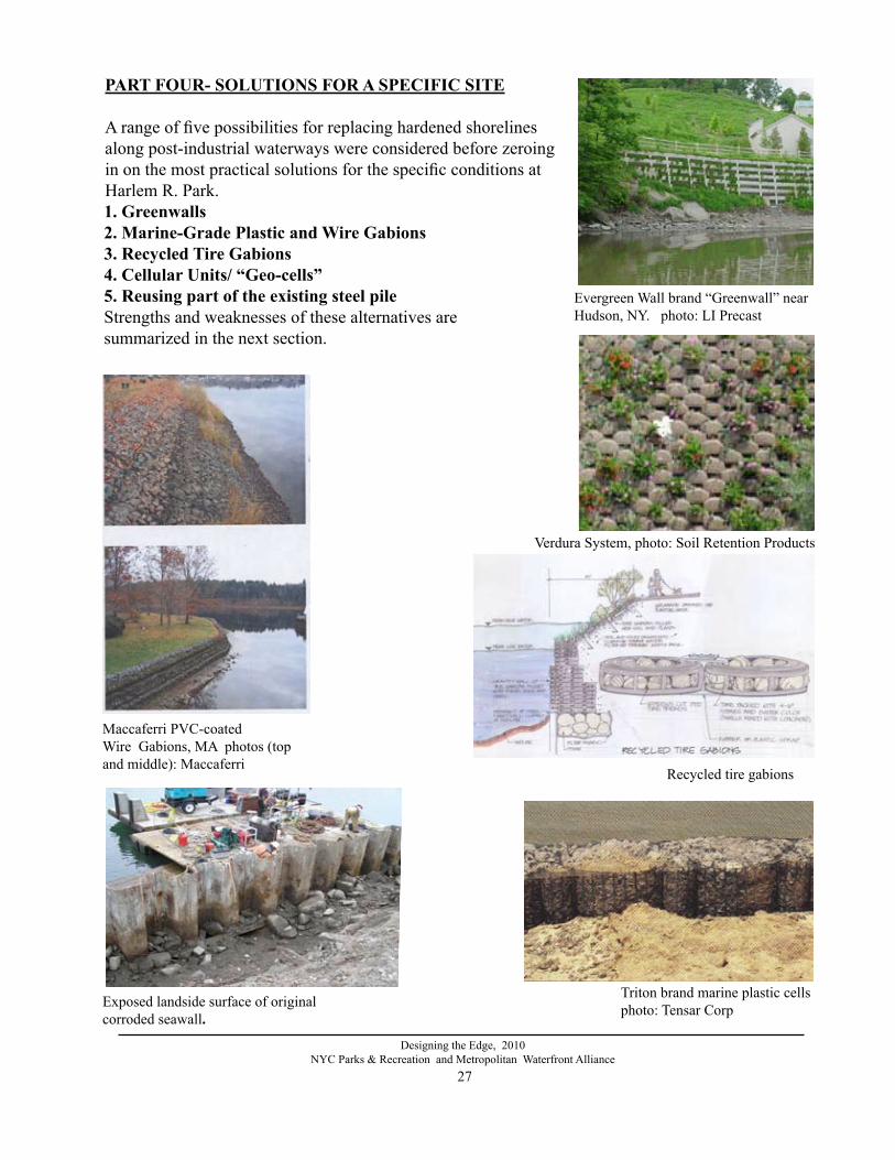
PART FOUR- SOlUTIONS FOR A SPECIFIC SITE
A range of five possibilities for replacing hardened shorelines along post-industrial waterways were considered before zeroing in on the most practical solutions for the specific conditions at Harlem R. Park. 1. greenwalls 2. Marine-grade Plastic and Wire gabions 3. Recycled Tire gabions 4. Cellular Units/ “Geo-cells”5. Reusing part of the existing steel pileStrengths and weaknesses of these alternatives are summarized in the next section.
Evergreen Wall brand “Greenwall” near Hudson, NY. photo: LI Precast
Recycled tire gabions
Triton brand marine plastic cellsphoto: Tensar CorpExposed landside surface of original
corroded seawall.
Verdura System, photo: Soil Retention Products

28
Designing the Edge, 2010NYC Parks & Recreation and Metropolitan Waterfront Alliance
EVAlUATION AND COMPARISON OF AlTERNATIVE APPROACHES FOR SEAWAll REPlACEMENT. greenwalls (battered gravity walls or vertically stacked with tie-backs)
1.“Verdura System,” by Soil Retention Products Inc, California : 18” concrete units with small plantable pockets, suitable for vines, grasses and small plants.
2.“Evergreen Wall,” supplied by Long Is. Precast, Brookhaven, Long Is. 16’ concrete stacking units with large soil volumes suitable for trees.
Greenwall advantages are that they are composed of masonry units with substantial strength andweight-bearing capacity. The plants do less of the work of holding the embankment.
Disadvantages are a) rigidity; they must not be allowed to flex as a natural shoreline does, b) they require a large footing, which is both expensive and displaces natural river bottom; c) they require heavy machinery to put them in place, and d) the openings are uniform in size,
and for intertidal zones, a range of stone sizes would be prefer able for habitat. Uniformly sized stone is preferable for the greenwall’s structural function.
Marine-grade Plastic, or Wire gabions (battered gravity walls or stacked, with stone or structurally reinforced soil)Five basic forms of pre-formed gabions were compared:
1. Twisted wire, vinyl-coated baskets (e.g, Macaferri Eco-gabions) with soil, rock, and culch (concrete made of shells). Where twisted wires create a tiny depression in the twisted joint, salt water which repeatedly is trapped there, may cause the PVC coating to degrade there first, creating a weak point in the twists. This does not seem to occur with the welded wire method.
2. Wire gabion with plastic crinkle mat (e.g, Enkamat) and/or filter fabric on the top horizontal face, for additional security for plantings and small particles
3. Welded wire, vinyl coated baskets (e.g, Modular Gabion Systems) with soil, rock, and culch 4. Photo-resistant plastic which is durable in salt water. This material does not rust at all, and has been tested to be long-lived and durable in the marine environment. However, at this time, these plastics have not been available as long as wire gabions, and field testing results over decades is not available. Durable plastics have a number of advantages over steel wire the most obvious that they don’t rust, which is the primary cause of degradation of steel marine infrastructure. 5. Stainless steel, marine-grade 316. The advantage of 316 stainless steel is that it is far more durable in salt water than galvanized steel. However, even stainless steel gets pitted from corrosive chemical reactions, and will rust eventually. The largest disadvantage of stainless is its high cost.
The advantages of gabions include flexibility, low cost and adaptability to different kinds of inte-rior materials. The small modular units can be hand-carried and placed; they can accommodate a variety of stone sizes and shapes, as well as soil. A critical disadvantage is that they are vulnerable to vandalism with a razor or wire cutter. If scraped by a large boat, the plastic may also be damaged by abrasion and ripping. In all types of gabions, longer durability results from packing the stones carefully by hand. This prevents tumbling movement within the basket, which is the source of the most damaging abrasion.

29
Designing the Edge, 2010NYC Parks & Recreation and Metropolitan Waterfront Alliance
Recycled Tire gabionsGabions can be made using rubber tires with windows cut out of the tread as the basket, linked with rubber or nylon straps, and filled with soil, rock, and shellfish culch (crushed shell cemented together).
By contrast with other gabions, tire gabions have the advantages of being very durable in saltwater conditions, very long lasting, and much harder to vandalize. By design, tires stack readily. They also have deeply incised treads to which shellfish, algae and other marine organisms can attach, so that habitat is provided not only by the interstices between stones, but also by the gabion frame it-self. In addition, the disc or cylindrical forms made by tire stacks function as both bumper and wall at the same time, absorbing the brunt of any boat bumping into it on the small areas of tire tangent to the impact. The biggest advantage is that they are a waste product. Not only are they inexpensive, but by reusing tires in a seawall, some of the waste stream is converted into a resource. The major disadvantage is that tire gabions are not currently produced and would have to be custom cut by the contractor.
Cellular Unit Retaining Walls or geocells1. Marine cells (e.g, Triton Marine Cells), vertical cylinders of
marine-grade plastic, filled with rock2. Cellular confinement systems using porous plastic sheets (e.g,
Webtec Terracell), with rocks and/or soil in open cells
One difference between building a seawall of plastic cells and one of wire gabions is the shape of the modules: cylindrical or other non-rectilin-ear volumes are similar to organic shapes found in tidal areas. Wave ac-tion is dissipated by laminar flow around a round object, so rounded cells may have an advantage in longevity as they do not break the the waves. The disadvantage for the Harlem River setting is that cylindrical forms are much larger than the size needed for the retaining wall.
Reusing part of the steel pile wallThe most corroded portion of older sheetpiles in the Harlem River is the “splash zone” between the mean low tide elevation and several feet below. The splash zone is usually underwater. Therefore, it is hard to see and easy to overlook when damaged. Intermittent exposure to air makes it vulnerable to rusting. Above mean high water, and lower than about 4 feet below the mean low tide, very little cor-rosion was found. The relatively sound metal outside the splash zone and driven deep into the riverbottom was estimated to have additional life of 20 years or more. There was a substantial economy in reusing the undamaged remaining sheetpile instead of building a new founda-tion for a greenwall or gabion wall.
Rusting steel sheeting along Harlem River Park
Photo: Webtech geocell

30
Designing the Edge, 2010NYC Parks & Recreation and Metropolitan Waterfront Alliance
Of the range of the materials and techniques reviewed, the following were considered feasible for Harlem River Park:1 Steel vertical sheeting (the standard approach to which we compared everything else)2 Recycled plastic vertical sheeting3 Concrete, poured in place within a coffer dam4. Concrete frame greenwall, for example, Evergreen Wall by L.I. Precast. 5 Modular concrete seawall, for example, Verdura by Soil Retention Products6. Wire gabion7. PVC-coated wire gabion8. Marine-grade plastic gabion9. Recycled tire gabion10. Marine-grade 316 stainless steel gabion (added as a substitute for plastic gabion, which became
too expensive)
Products and techniques inappropriate for this situation, but potentially useful in other contexts:
1. Mechanically stabilized earth (MSE), involving layers of geotextile and compacted earth behnd a retaining wall2. Marine grade plastic cellular confinement system, for example Terracell by Webtec 3. Ecogabions, for example by Maccaferri; a coated steel mesh interwoven with coated flexible crinkled erosion-controlling strands 4 Geofoam5. Bioengineering techniques: combining living plants and fabrics, masonry or other structures so that plants holding the slope are reinforced by other materials, for example:
a. Planted riprapb. Live fascinesc. Brush layered slopesd. Gridded soil retention systems; vegetated geogride. Terraced, vegetated slopes using erosion mattress; brush mattressf. Bales with live stakesg. Vegetated crib wall h. Branch packingi. Vegetation combined with erosion control blankets, mats and cribbing and many
variations
Illustrations: C. Fransworth based on R. Sotir and S. Jones published in Sustainable Landscape Construction, 2000

31
Designing the Edge, 2010NYC Parks & Recreation and Metropolitan Waterfront Alliance
Photo: Tensar Marine- Grade Plastic Gabions
Photo: Tensar Marine-Grade Plastic Gabions
- Horizontal or gently sloped surfaces, with shallow water zones penetrated by light.
- Capacity to reduce flow velocity: such as irregular, staggered or curvilinear forms.
- Capacity to absorb wake energy instead of reflecting it, reducing scour and impact on the structure of the shore.
- Capacity to grow plants.
- Porous; able to filter storm water through aerobic layers of soil, allowing microorganism activity to cleanse water feeding into the river; bioremediation. - Durable, especially against salt corrosion, vandalism, wake action, ice scour, freeze/thaw expansion.
- Able to accommodate hand-powered boats. - Able to accommodate larger boats for visiting programs and emergency evacuation.
- Cost.
CRITERIA FOREVAlUATINg AlTERNATIVE WATER EDgE DESIgNS AND MATERIAlS The following considerations were taken into account, not in order of priority, but taken as a whole.
- Availability as an “off-the-shelf” system, or easily feasible custom product. All of the products except recycled tire gabions are “off the shelf “ and seemed to be available during the design stage. Plastic gabions, one of the preferred products supplied, was apparently available, but priced much higher by the intermediate supplier to the contractor than the original quote during design.
- Capacity for improving/supporting habitat: rough texture to enable attachment of algae and filter-feeding organisms, variety of interstitial spaces for different of invertebrates and fish, opportunity to incorporate culch to attract shellfish such as mussels and oysters.
- Expected longevity; resistance to vandalism and marine conditions.

32
Designing the Edge, 2010NYC Parks & Recreation and Metropolitan Waterfront Alliance
Capacity for improving habitat. Gabions and greenwalls rank high in habitat potential because of the degree of porosity and the variety of pore spaces between the stones. Culch (crushed shell) or whole clam or oyster shells can be added to the stones in gabions and greenwalls to increase the number of shellfish that will attach to them.
Solid sheeting, whether steel, recycled plastic or concrete, ranks lower because it lacks the attributes of porosity, rough texture and slope. Concrete, however, is the best of the three and can be delib-erately formed with rough surfaces, pits and pockets that support estuarine life. Its alkalinity has also been shown to be attractive to oysters and some other marine organisms, which will sometimes attach to concrete even in preference to natural stone.
Horizontality. Gabions, greenwalls and modular stacking systems lend themselves to being terraced and sloped in differ-ent ways. Varied terrace width, height and degree of shoreline slope provides diverse microhabitat niches, for example, zones which receive different amounts of direct sun.
Capacity to reduce flow velocity.Because of the channel wall on one side and sometimes on both sides of the Harlem River, and further constrictions due to bridge supports in mid stream, its flow velocity is artificially intensified. For the safety of people using the river for recreation and to reduce the erosion potential of the stream, shoreline structures with the capacity to slow the nearshore current are desirable.
Moderating flow can be accomplished by increasing the roughness or friction of the river’s banks and making the bank slope gentle to increase the volume of the river’s “container.”
Irregular, staggered and curvilinear forms, by contrast with straight sections of vertical sheeting, reduce velocity by forming small eddies along the roughly-textured shore. This diverts some of the flow in many directions in three dimensions, cumulatively slowing the current. Rounded tire gabions rank very high in ability to be arranged in diverse curvilinear shapes. Prefabricated greenwalls with smaller modular units can most easily be used to create curved walls. Concrete-frame-style green-walls and standard block-shaped gabions are best used in rectilinear shapes. These can be staggered and recessed to create corners that are very good at producing eddies. Corners, however, are more vulnerable than rounded points to being worn down by the current, floatable debris and bumps by boats.
Wake absorption capacity. Creating a seawall that absorbs and dissipates the erosive energy of incoming wakes or waves could do much to reduce the need for massive structures in the littoral zone. Absorbing wave energy is related to: 1) porosity, which allows wave impact to be received gradually instead of abruptly; 2) a sloping surface that gives waves a longer and shallower inboard run; and 3) flexibility so that minor movements do not stress the integrity of the structure. 1) Porosity. Pores allow wave impact to be received gradually. Pore space in the soil not only ab-sorbs storm runoff and slows flood waters, it also provides oxygen for helpful bacteria, which filter or
Greenwall mockup for Ph. 3

33
Designing the Edge, 2010NYC Parks & Recreation and Metropolitan Waterfront Alliance
metabolize many water-borne pollutants in urban runoff. The least porous of the alternatives is metal or plastic sheeting, followed by concrete walls. The most porous are gabions and concrete open frame style greenwalls. The retaining wall block-style greenwall is porous only within its small volume of soil. 2) Sloping interface. A concrete seawall could theoretically be poured in place or as custom-built modular, aerodynamically curved shapes, or pleated conical forms modeled after the “architecture” of rocky intertidal organisms evolved to withstand great forces. The shape of a Whelk, for example, could be a model for a convex wall that lets wakes sheet off without breaking forcefully. The shape of a ribbed barnacle, for example, could be a model for a pleated or corrugated form which uses a thinner but strong material. Such custom designs would at first be far more expensive than tire gabions that need only minor modification, or than standard seawalls.
3) Flexibility. Minor movements do not compromise the function of flexible structures. Gabion walls of steel, plastic or tires are inherently flexible; the stones can move slightly within the baskets; the baskets are linked together in ways that allow them to stretch, buckle and settle without breaking or undermining the strength of the structure. They can deform without loss of function. The other alternatives are all inflexible and depend on a rigid foundation.
Capacity to grow plants. Concrete frame greenwalls are designed to hold a large volume of soil, which gives them capacity to grow communities of trees and smaller plants in a way which mimics the way earthen shores are vegetated naturally. Plantable retaining wall blocks can support plants with relatively small root systems, including vines, grasses and ground covers. Level earthen terraces can be created with short retaining walls between the terraces, which can support trees and a variety of other plants. Vertical sheet piles of any metal or steel only support plants when they are broken. Concrete vertical walls often have joints, reveals, and attached wooden fenders, which, when weathered, may harbor vol-unteer wild grasses and flowers. Gabions, having stones and voids between the stones, can absorb sediment deposited by the river in the slower water at the shoreline. On the other hand, in turbulent conditions, sediment can be resuspended out of the gabions. If water is quiet enough, sediment will build up and harbor intertidal plants at marsh level. Above the high tide level, gabions can be packed with soil and grow plants, whose roots will reinforce the erosion-controlling function.
Capacity to integrate tidal pools.It is relatively easy and inexpensive to adapt riprap revetments and gabions to include intertidal pools. Any seawall which can be terraced or built with cavities in the intertidal zone can also be modified to include tidal pools. Cost.The cost of installing different types of shorelines involves much more than just the final surfaces Variables include: • The amount of excavation needed to install the footing as well as the seawall • Whether a coffer dam is needed to exclude water during wall construction• Whether dewatering and constant pumping is necessary• How deep the water is along the seawall, and whether depth is constant• Whether piles are needed, and their depth and frequency• Whether new fill is needed• Whether bracing, dead men or mechanically stabilized earth are needed
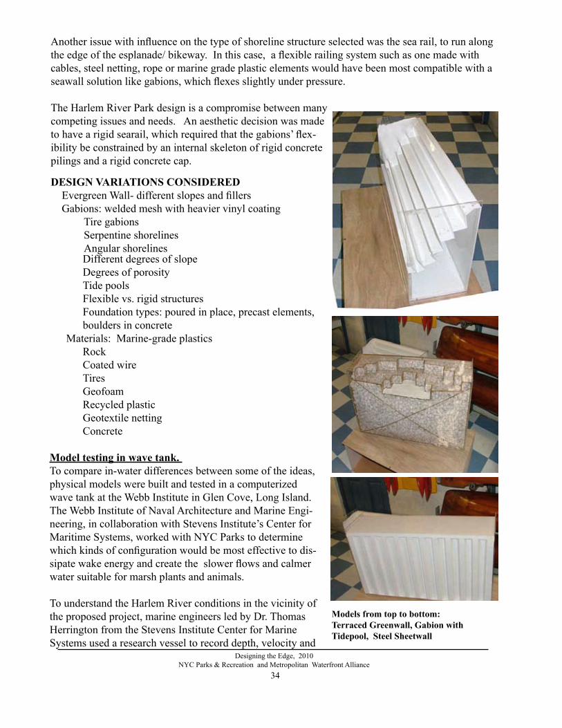
34
Designing the Edge, 2010NYC Parks & Recreation and Metropolitan Waterfront Alliance
Different degrees of slope
Degrees of porosity Tide pools Flexible vs. rigid structures Foundation types: poured in place, precast elements,
boulders in concreteMaterials: Marine-grade plastics
RockCoated wire Tires GeofoamRecycled plasticGeotextile nettingConcrete
Model testing in wave tank. To compare in-water differences between some of the ideas, physical models were built and tested in a computerized wave tank at the Webb Institute in Glen Cove, Long Island. The Webb Institute of Naval Architecture and Marine Engi-neering, in collaboration with Stevens Institute’s Center for Maritime Systems, worked with NYC Parks to determine which kinds of configuration would be most effective to dis-sipate wake energy and create the slower flows and calmer water suitable for marsh plants and animals.
To understand the Harlem River conditions in the vicinity of the proposed project, marine engineers led by Dr. Thomas Herrington from the Stevens Institute Center for Marine Systems used a research vessel to record depth, velocity and
DESIgN VARIATIONS CONSIDERED Evergreen Wall- different slopes and fillers Gabions: welded mesh with heavier vinyl coating
Tire gabions Serpentine shorelines
Angular shorelines
Another issue with influence on the type of shoreline structure selected was the sea rail, to run along the edge of the esplanade/ bikeway. In this case, a flexible railing system such as one made with cables, steel netting, rope or marine grade plastic elements would have been most compatible with a seawall solution like gabions, which flexes slightly under pressure.
The Harlem River Park design is a compromise between many competing issues and needs. An aesthetic decision was made to have a rigid searail, which required that the gabions’ flex-ibility be constrained by an internal skeleton of rigid concrete pilings and a rigid concrete cap.
Models from top to bottom: Terraced greenwall, gabion withTidepool, Steel Sheetwall
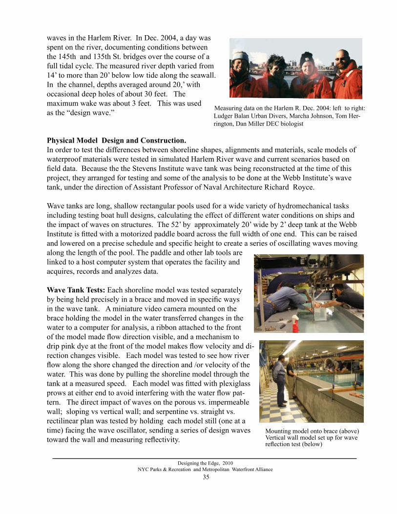
35
Designing the Edge, 2010NYC Parks & Recreation and Metropolitan Waterfront Alliance
Physical Model Design and Construction. In order to test the differences between shoreline shapes, alignments and materials, scale models of waterproof materials were tested in simulated Harlem River wave and current scenarios based on field data. Because the the Stevens Institute wave tank was being reconstructed at the time of this project, they arranged for testing and some of the analysis to be done at the Webb Institute’s wave tank, under the direction of Assistant Professor of Naval Architecture Richard Royce.
Wave tanks are long, shallow rectangular pools used for a wide variety of hydromechanical tasks including testing boat hull designs, calculating the effect of different water conditions on ships and the impact of waves on structures. The 52’ by approximately 20’ wide by 2’ deep tank at the Webb Institute is fitted with a motorized paddle board across the full width of one end. This can be raised and lowered on a precise schedule and specific height to create a series of oscillating waves moving along the length of the pool. The paddle and other lab tools are linked to a host computer system that operates the facility and acquires, records and analyzes data.
Wave Tank Tests: Each shoreline model was tested separately by being held precisely in a brace and moved in specific ways in the wave tank. A miniature video camera mounted on the brace holding the model in the water transferred changes in the water to a computer for analysis, a ribbon attached to the front of the model made flow direction visible, and a mechanism to drip pink dye at the front of the model makes flow velocity and di-rection changes visible. Each model was tested to see how river flow along the shore changed the direction and /or velocity of the water. This was done by pulling the shoreline model through the tank at a measured speed. Each model was fitted with plexiglass prows at either end to avoid interfering with the water flow pat-tern. The direct impact of waves on the porous vs. impermeable wall; sloping vs vertical wall; and serpentine vs. straight vs. rectilinear plan was tested by holding each model still (one at a time) facing the wave oscillator, sending a series of design waves toward the wall and measuring reflectivity.
Mounting model onto brace (above)Vertical wall model set up for wave reflection test (below)
waves in the Harlem River. In Dec. 2004, a day was spent on the river, documenting conditions between the 145th and 135th St. bridges over the course of a full tidal cycle. The measured river depth varied from 14’ to more than 20’ below low tide along the seawall. In the channel, depths averaged around 20,’ with occasional deep holes of about 30 feet. The maximum wake was about 3 feet. This was used as the “design wave.” Measuring data on the Harlem R. Dec. 2004: left to right:
Ludger Balan Urban Divers, Marcha Johnson, Tom Her-rington, Dan Miller DEC biologist

36
Designing the Edge, 2010NYC Parks & Recreation and Metropolitan Waterfront Alliance
(2) The serpentine tire wall generates very large (the size of each curved portion of the wall) eddies along the wall. These eddies extend from the point at which the two curves join at the center of the wall back to the center of each curve. The eddies turn in a clockwise rotation. It appears as though the water undergoes one rotation and then is trans-ported into the free stream offshore of the model. When the model draft was lowered by 2feet, so that the sloping section of the tire wall was in the water, some ponding of the dye appeared in the leading cove, but most of the flow remained parallel to the wall with little reduction in velocity.
(3) The tidepool cove in the gabion wall was very effective in ponding dye at all tow speeds. The dye would slowly rotate clockwise and remain in the cove for some time after the dye injection was stopped. The faster the tow speed, the less time the dye re-mained in the cove.
(4) The greenwall slowed the flow of the dye at the leading edge of the model. Interestingly, the dye appears to by forced downward along the face of the model until approximately 1/3 of the distance (along the water line) down the model, all of the dye is transported out into the free stream offshore of the model.
(5.) All porus walls reduce wave reflectivity. Construction of the models did not accurately portray the degree of porosity in a real gabion or greenwall.
(6) Any divergence from vertical toward a more horizontal slope (20-45%) reduces velocity; the gentler the slope, the more reduction.
CONClUSIONS OF WAVE TESTINg:Either gabions or greenwall structures are recommended for slowing the flow of water along the edge of the Harlem River so that suspended particulates and organisms settle into the structure. Sloping or terracing the wall is an added benefit for that purpose. Although the serpentine tire wall generates significant eddies, they only occur when the waterline intercepts the vertical portion of the wall, not the sloping section where sedimentation is desirable. The greenwall appears to dramati-cally slow the nearshore flow. However, the downwelling of dye along the face of the greenwall is a safety and stability concern. Downwelling may eventually remove material from the wall.
RESUlTS: In brief, computer analysis of the video im-ages confirmed what was observed during the tank tests:
(1) A verical sheet pile wall does little to slow the flow of water along the edge of the river. Small vortices are formed in the recessed portion of the Z-shaped panels. These vor-tices are quickly shed into the mean flow along the edge of the wall. Waves are fully reflected.
Testing model of serpentine form tire gabion wall
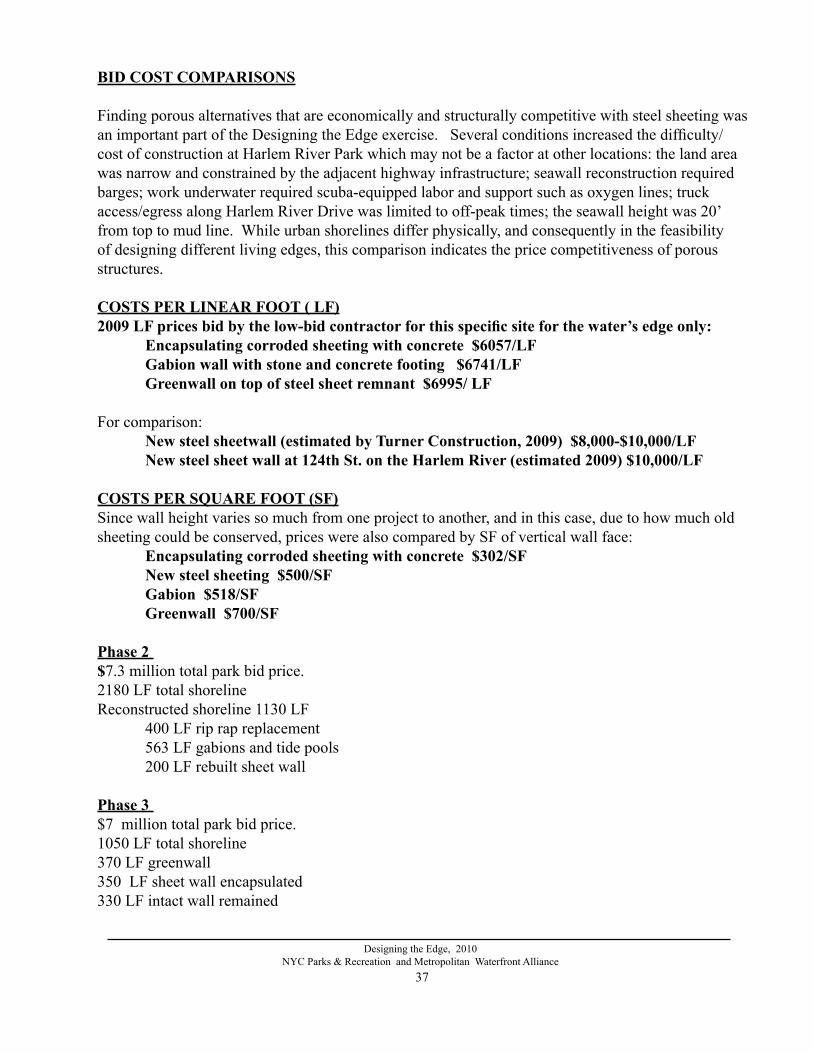
37
Designing the Edge, 2010NYC Parks & Recreation and Metropolitan Waterfront Alliance
BID COST COMPARISONS
Finding porous alternatives that are economically and structurally competitive with steel sheeting was an important part of the Designing the Edge exercise. Several conditions increased the difficulty/ cost of construction at Harlem River Park which may not be a factor at other locations: the land area was narrow and constrained by the adjacent highway infrastructure; seawall reconstruction required barges; work underwater required scuba-equipped labor and support such as oxygen lines; truck access/egress along Harlem River Drive was limited to off-peak times; the seawall height was 20’ from top to mud line. While urban shorelines differ physically, and consequently in the feasibility of designing different living edges, this comparison indicates the price competitiveness of porous structures.
COSTS PER lINEAR FOOT ( lF)2009 LF prices bid by the low-bid contractor for this specific site for the water’s edge only: Encapsulating corroded sheeting with concrete $6057/LF Gabion wall with stone and concrete footing $6741/LF Greenwall on top of steel sheet remnant $6995/ LF For comparison: New steel sheetwall (estimated by Turner Construction, 2009) $8,000-$10,000/LF New steel sheet wall at 124th St. on the Harlem River (estimated 2009) $10,000/LF
COSTS PER SQUARE FOOT (SF)Since wall height varies so much from one project to another, and in this case, due to how much old sheeting could be conserved, prices were also compared by SF of vertical wall face: Encapsulating corroded sheeting with concrete $302/SF New steel sheeting $500/SF Gabion $518/SF Greenwall $700/SF
Phase 2 $7.3 million total park bid price.2180 LF total shoreline Reconstructed shoreline 1130 LF 400 LF rip rap replacement 563 LF gabions and tide pools 200 LF rebuilt sheet wall
Phase 3 $7 million total park bid price. 1050 LF total shoreline 370 LF greenwall350 LF sheet wall encapsulated330 LF intact wall remained

38
Designing the Edge, 2010NYC Parks & Recreation and Metropolitan Waterfront Alliance
Itemized bid prices for the gabion wall and greenwall:
Gabion wall, Phase 2 (139th-142nd St.) , bid 6/22/06, Phoenix Marine Contractor for NYC Parks ¾ of Total Excavation 6000 CY, $54/CY $324,000Temporary sheeting 21880 SF, $30/SF $656,400Geotextile for drainage 380 SY, $7/SY $5,810Geotextile for separation 177 SY, $8/SY $13,600Controlled concrete 73CY, $1500/CY $109,500Steel bar reinforcing 8100 LB, $3.25/LB $26,325Polymeric gabions 1490 CY, $350/CY $521,500Stainless steel wire mesh (gabion) 6540 SF, $14/SF $45,780Routed extra heavy stone fill 1860 CY, $200/CY $372,000Steel pipe piles 1340 LF, 75/LF $100,500Plug holes in exist sheeting 1536SF, 200/SF $307,200Remove existing sheeting 523LF, 700/LF $355,100Recycled plastic lumber pile/rail fender 23LF, 120/LF $62,760Recycled plastic lumber fender 444LF, $350/LF $155,400Chained tire fender 523 LF, 250/LF $130,750Dewatering 120 Days, $2000/day $240,000Stone tide pool 550SF, 100/SF $55,000Clay liner 400SF, 110/SF $44,000 ======================================================================= $3,525,625 / 523LF = $6741/LF13’ vertical face X 523 LF= 6799 SF of wall surface$3,525,625/ 6799 SF = $518/SF of porous wall
Greenwall, Phase 3 bid 4/30/07 (142nd St.- 145th St.) Phoenix Marine Contractor, NYC EDC ¾ of total Excavation LS $262,500 $262,500Removal of existing conc. cap 118 CY, $500/CY $59,000Modify exist. Sheetpile LS 20,000 $20,000Remove exist tie rod 33 EA, $300/EA $ 9,900New tie rod 36 EA, $1000/EA $36,000Modify exist. anchor 153 CY, $3000/CY $459,000Patch seawall (plate+coat) 12 EA, 4500/EA $54,000Curb on new cap 23 CY, $1500/CY $34,500Conc. Connection block for tie rods 67 CY, $2500/CY $167,500Helical anchors 92 EA, $4500/EA $414,000Precast footings 28 CY, $4000/CY $112,000Gravel bedding 147 CY, $150/CY $22,050Geotextile 1676 SY, $20/SY $33,520Armor layer-slope protection 687 Tons, $400/T $278,800Filter layer- slope protection 221 Tons, $175/T $38,675Evergreen units- Size C 18 EA, $4000/EA $72,000Evergreen units- Size D 10 EA, $4500/EA $45,000Evergreen units- Size E 41 EA, $5000/EA $205,000Tremie concrete LS $175,000=======================================================================10’ vertical face X 370LF= 3700 SF of porous wall face 2,588,445 / 370 LF = $6995/LF$700/SF porous wall face
Encapsulating sheetwall with concrete$2,120,000 / 350LF = $6057/LF20’ vertical X 350LF= 7000 SF $2,120,000 / 7000 SF= 02/SF wall face
Sheetwall replacement at 124th St. / Harlem River $10,000/LF. (estimated) If 20’ wall, = $500/SF wall face

39
Designing the Edge, 2010NYC Parks & Recreation and Metropolitan Waterfront Alliance
PART FIVE- CONClUSIONS FOR A lIVINg SHORElINE
Old, crumbling shorelines naturalize spontaneously because they are porous, flexible and have abundant moisture at the interface of air, water and earth. At the same interface (the intertidal or littoral zone), however, designed urban waterfronts are typically dominated by vertical seawallswith scant opportunities for naturalizing. Consequently, an important ecological opportunityexists: to design new, cost-effective shoreline structures in lieu of seawalls, and to infuse those newforms with porosity, flexibility, planting pockets, and shallow water zones that support aquatic lifeand human interactions with the water.
The design solutions for Harlem River Park demonstrate a few of the many ways to create a living shoreline that reinforcesitself through the growth of plants and shellfish. Roots, stems and branches knit the upland surfaces together to resist erosion and filter polluted urban runoff. Shellfish attracted to the curved, sloped, flexible marine structures that replaced the old seawall are expected to form a living crust that resists ice and wake scour and dissipates wave energy to make calmer waters for recreational use. Shellfish also filter water as they feed, helping to improve water quality. Providing access for small and large boats help city folk get out on the water. Shallow tidal pools create safe, shallow wet areas where people can explore the living richness of their river.
The three recent phases of the park side by side with the undeveloped south portion present a wonderful opportunitychance to compare different ways to deal with a post-industrial river edge: old sheet walls, new steel sheetwalls, rock revetment, gabions with shells incorporated to attract shellfish, tidal pools set into the gabions, and terraced concrete “green walls” with native riveredge shrubs and grasses. Monitoring the biological and physical changes that occur during the next few years at Harlem River Park will enable better prediction of ecological benefits from porous seawalls, and the impacts of weathering, ice scour, boats and public use on shoreline materials.
Harlem River’s natural edge, Bronx side Tidepool, Harlem River Park, Oct. 2009 just after construction

40
Designing the Edge, 2010NYC Parks & Recreation and Metropolitan Waterfront Alliance
APPENDIX 1. TRANSCRIPT OF COMMENTS FROM COMMUNITY WORKSHOPTOPICS RAISED AT COMMUNITY WORKSHOP 10/2/04
SUMMARY: There was a trend toward consensus on the following ideas:Steps and terraces to get down to the water; Access for boats, especially in case of an evacuation emergency; Commemorating the history and culture of E. Harlem; Encouraging environmental awareness and advising people about the danger of eating fish from pol-luted water; Making the water’s edge aesthetically attractive, not fencing off the water but including a barrier which is attractive and naturalistic (not a fence); As few barriers as possible. Using the park to cleanse the environment (bioremediation, filtration, etc)
The Red and Blue group:1. Making a mosaic or mural on the seawall, or a bas-relief, with images of the colors of dawn (the wall does face East) , moon, stars, sky images; Harlem history2. Set of curved shallow terraces like a ribbon of several waved curves, perhaps with tidepools, per-haps with lawn on the horizontals and stone on the risers. 3. Set of shallow steps (not steep) with space to let marsh grasses grow through, such as behind or between each tread4. Controlled access for boats, esp. for emergency evacuation and rowing5. Connection from the ramp down to the water level6. Use of the wall for growing flowers , other plants; Use of the ramp walls to grow ivy or have hanging planters7. Access for the disabled8. Community involvement in the plantings…on the model of community gardening9. Good surveillance10. Control erosion
Yellow Group1. Access2. Soft, green, restful, meditative3. Jogging path extension/connection4. Teaching children to interface with ecology. Interpretive trail information. 5. History of Harlem, Harlem Hell fighters (associated with the 142nd St. Armory) 6. Boat Access7. Seasonal color and flowers8. A Manhattan Schist wall… use local material that fits with the setting9. Steps down into the cove from the sidewalls10. Variety of seawall types11. Naturalistic-looking concrete wall made with dredged material from the river

41
Designing the Edge, 2010NYC Parks & Recreation and Metropolitan Waterfront Alliance
Green Group1. Filtering functions of the soil and plants2. Places for children; testing for environmental improvement (mercury levels, etc) good opportunity for understanding the urban environment3. Shelter/canopy4. A Pier…safe access for the Circle Line, ferries5. Use a natural barrier to protect against unsafe contact with the deep water6. A people-friendly barrier7. Post fish advisories8. Set of steps 7. Natural bridge (physical and metaphorical) between the community and the river8. Highest security near the high tide level9. Access from the highway ramps: how can you see the way to get to the river?
Exaggerate/ accentuate the sense of nature; but not just wild and unkemptSelf-maintaining landscapeThe contrast of native plants and the perception of the industrial/ hard edged riverUse monitoring of pollution levels as a way to educate kids.
Other ideas from the workshopSafety concerns:Pitbulls (and their owners) sometimes take over the park, people are afraid to use the parkWhat is the perception of “natural?” If it looks like weedy growth it may be perceived as unkemptSecurity for NY Harbor; Harlem R. a potential entry for terrorists
Filter feeding shellfish, etc.Need a mechanism for protecting people from eating the shellfish; renovating (removing old ones and establishing new ones) population if they are actively used for filtrationHaving the park plants and earth contribute toward the cleanup of Harlem River via filtration, biore-mediationDidn’t like the look of culch bagsThe water’s edge can create a sense of community…something to gather and learn about…but it’s not the community’s responsibility to maintain and remove cleansing plants and other organismsSuspicions that the bio-accumulated shellfish won’t be taken away, and could present an on-going hazard and/or maintenance issue
ConnectionsFoot bridge across the revetment area, arched to allow light to the shoreFootpath on the Bronx side looking across to the Manhattan side Clarify how one can get to the park: post maps, things you can do thereConnections to the rest of the waterfront, esp. the continuous bike path around ManhattanInterest in a ferry stop/ Circle Line or water taxi dockConsider the entrances at 135 and 139: widening the links, looking to discuss with DOT maybe a ramp dropping down; Can’t see a way to widen the pedestrian access. Visual access to the river from the inboard community; how can linkages and passageways to the park be made known to the public?

42
Designing the Edge, 2010NYC Parks & Recreation and Metropolitan Waterfront Alliance
Illustrate the history of Harlem along the ramps, to draw you across the highway to the park. 5th Ave. pedestrian access esp. needs an element that suggests a purpose to go across to the park.
BathroomsPutting part of the bike route under the highwayPutting part of the bike route up on the ramps
Historically (until HR Driver was extended in 1960’s) much of Harlem R. was riprap, not seawalls.
Aesthetics of the wallMake it attractive and interestingCommemorate some aspect of E. Harlem culture, community, people, environment
Break out Group NotesDesigning the Edge WorkshopOctober 2, 2004
NB: Each group worked with a variety of mediums to produce a scaled model of the edge treatment they would like to see on the Harlem River.
At the conclusion of the hour each group chose one representative to present their model to the group. Michael Lee Poy presented his group’s model, which included steps to reach the water, a pier for boats (such as Circle Line) to dock, and a tidal pool. Next, Naomi Langley presented her group’s model. This model consisted of steps to reach the water and a variety of plant life growing on the steps. Finally, Tom Harrington and Chris Williams presented their idea. Their group hoped for a “natural bridge” that might connect the community to the water in a new way. Richard Touissant also presented his initial concept for this area of the Harlem River Park, a board walk over the water and a rip rap edge that provides access to the water at the site. Mr. Touissant also pointed out that for many people growing up in the neighborhood, including him, this was the sole place where you could access the water. A brief question and answer period followed the presentations.
Green Group
What would you like the Harlem River edge to look like?
A natural bridge between the water and the community.
Yellow Group
1. What would you like the Harlem River edge to look like?

43
Designing the Edge, 2010NYC Parks & Recreation and Metropolitan Waterfront Alliance
natural, gardens, flowers, attractive, soft, green, resting, something that commemorates the commu-nity, recreation, biking with path, jogging, teach kids interface between marine environment: land & ecology, interpretive trail with signs telling history and ecology of Harlem River,buffer between FDR site, sound (acoustic), visual, access points to Circle Line, all cruise crafts north and south, docking capabilities, edge where one can access water, edge that helps recovery of water quality, want to see sculpture: wildlife, barbeque pits: ability to eat, tennis cart, floating swimming pool. place for events, concerts, fairs, soccer, soft edge sloping to river gently, not a linear edge but a meandering one, people need to get closer to water, beach/ tidal pools, art must be a part of edge, di-verse edge treatments, many kinds of edge, natural rock area, Manhattan shist for edge wall, diverse trees, with differing colors, native plants as much as possible, retain storm: filter storm water—have functional element, something hands on for kids, shelter canopy, space for sitting/ viewing/relaxing, space for disabled, access to non-motorized boats and other crafts, no steel sheet piles.
2. Can you imagine a river edge where the seawall lets people get close to the water safely? Yes—type of seawall?
Bring back piers—safe way to access water, steps, stairs, tide pool, wall with plant life, elevation of seawall is a factor in safety, no man made fences or barriers—use natural ones, barrier must be people friendly, as few barriers as possible, a lot of variety to sea walls—some steep like a cliff, some more inviting to walk down, natural sloping steps. terracing, use dredged materials band with cement, use old parts of torn down buildings (i.e. washburn factory as part of material wall), must be durable with vegetation, wall must have flowers, wall allowing for walkway/ vegetation/ boat moor/ habitat, wall should do many things at once, wall allows for sitting viewing/ activities/ moving.
3. Can you imagine a park river edge which would be perfect for fisherman: also the fish?
Why would you want to fish (eat fish) if water is polluted?Have a lot of advisories in multiple languages at areas where one can fish, pier (like in past), if its perfect for fishermen, it can’t be perfect for the fish, good fish habitat has to be irregular, but this can be bad for fishermen, that’s why pier or dock should be designed for fishing. pile on piers should be designed to attract fish: plants. Create healthy bottom of river so we need submerged aquatic vegetation for example. Fishing area must not be too close to wake or absorbs wake action—perhaps restricting speed: weight of vessel in harbor. Areas for fishing should attract people (not just fish)—perhaps benches, fish cleaning area but this promotes eating, is this ok? Create structure that attracts fish and provides habitat.Art on pier to attract people.Don’t want cleaning areaWaterfront should represent local community.
TOPICS RAISED AT MEETING WITH CB11 ARTISTS, 9/30/04
They would like to walk the site together to discuss ideas (set up for Nov. 6, 1:00)The park should have the “handprints” of E. Harlem participation Use the park green space and soil for filtering water

44
Designing the Edge, 2010NYC Parks & Recreation and Metropolitan Waterfront Alliance
Use a sculpture to help cleanse the site using microorganismsActivated charcoal combined with the soil as a filterHarlem R. water could be used as a source of energy
Randall’s Is. Asbestos may be a problem in the soil. Teach young people about the river: ask that Park Rangers run env. education programSuch as being done by Clearwater; perhaps a conservancy for environmental education such as at Curriculum of art and healing, especially for childrenIt is especially good for people to see the work of local artists who they actually know, out in public.
Concerns raised: Time frame is too short; always too little time when people come to E. Harlem with ideas.
Action items:Try to get report on fish toxicity/ danger of eating fish, to local schools. Let the children bring infor-mation homePost warnings against eating the fish; crabs.
Facilitators from Imagine New York and Harlem Community Development CorporationLourdes HernandezEllis BlankMichael FishmanDave or Matt ArneChris Williams
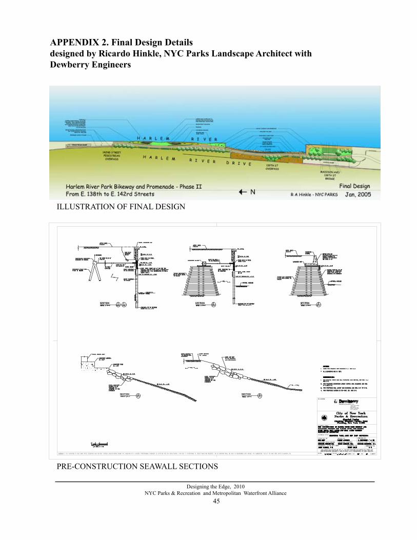
45
Designing the Edge, 2010NYC Parks & Recreation and Metropolitan Waterfront Alliance
APPENDIX 2. Final Design Detailsdesigned by Ricardo Hinkle, NYC Parks landscape Architect with Dewberry Engineers
ILLUSTRATION OF FINAL DESIGN
Dewberry-Goodkind, Inc.15 EAST 26TH STREET13TH FLOORNEW YORK,NY 10010PHONE: 212.685.0900FAX: 212.685.2340
PRE-CONSTRUCTION SEAWALL SECTIONS

46
Designing the Edge, 2010NYC Parks & Recreation and Metropolitan Waterfront Alliance
TITLE SHEET OF CONSTRUCTION DRAWINGS Full set of drawings is available for viewing by appointment at NYC Parks & Recreation Olmsted Center Map File, (718) 760-6798
4
B B
B B
F
E
D
OPEN WATER AND TIDAL ZONE LAYOUT

47
Designing the Edge, 2010NYC Parks & Recreation and Metropolitan Waterfront Alliance
LAYOUT - PLAN C 139 th St. - 142nd St.
LAYOUT - PLAN B 135TH St. - 139th St.
30'-
8"
39'-
1"
9'-5
"
15'-7"
12'-0"12'-0"12'-0"12'-0"16'-0"
6'-0
"
1'-3"
56'-0"
1'-6
"
1'-6
"
1'-6
"
9'-6
"
13'-8"23'-2"14'-0" 7'-10"
4'-9"
8'-6" 6'-6" 5'-6"
GG
BBBBBBBBB
BB
BB
B
B
B
BB
• • ••••
PP
PPPP
PPPP
2
3
2
43
2
3
2
1
2
1
RICARDO HINKLE, RLARICARDO HINKLE, RLA CHRIS CROWLEY, RLA
MICHAEL BOLGER, RLA DAVID CARLSON, RLA
JOHN NATOLI, PE
1"=10'-0" 10M208-104M
LAYOUT PLAN - B
47APRIL, 2005
2
2
B
B
1
3
Harlem River Drive
Harlem River
139th St. Onramp
1
1
1'-6
"
10'-0"
10'-0"
A
A
A
3
6' - 8'+/-
16'-
6"
100'-0"
5' 5'
TYP.
CENTERLINESTONE BLOCKS
5
THE CONSTRUCTION OF HARLEM RIVER PARK BIKEWAY AND ESPLANADEBETWEEN THE HARLEM RIVER, THE HARLEM RIVER DRIVE,EAST 139TH AND EAST 142ND STREETSBOROUGH OF MANHATTAN
A 1
9
2
##
##
XY
XY
2
3 2
S
P
T
8
1
4
B1 G
W
5
3B
2
4
5
6
139th St. Onramp
Harlem River
Harlem River Drive
56'-0"TO CENTERLINE OF SEATING ALCOVE
12'-0"12'-0"24'-0"42'-0"
12'-0"12'-0"12'-0"12'-0"
6'-0"42'-0" 12'-0"18'-0" 18'-0"18'-0" 18'-0"
5"
1'-6
"
1'-6
"
36'-2"
3'-0
"
6'-3
"
39'-3
"
R
99'-
3"R
3'
L=17
'-6"
L=34
'-8"
7'-0
"
3'-0
"
6'-9
"
8'-6"5'-6" 6'-6"4'-9"
3'-0
"
1'-1
"
7'-3
"
8'-4
"
6'-1
" 4'-0"
18'-0"24'-0"
45'-0"RL=18'-9"
22'-1"
R
1'-6
"
1'-6
"1'-6
"
1'-6
"
1'-6
"
1'-6
"
1'-6
"
1'-6
"1'-6
"1'-6
"
1'-6"1'-6
"
UPLAND REVETMENT
TIDEPOOL
72'-
0"R 22'-6"
UPLAND REVETMENT
TIDEPOOL
L=13'-3" 3'-0
"
3'-0"
12'-0"24'-0"24'-0" 12'-0"
6'-0"
24'-5"
3'-6
"
5'-6
"
600'
-0"
R L=27
'-3"
R=400'
L=21'-10"
3'-0"R
5'
L=30
'-6"
BLUESTONE SLAB WALL
L=61'-6"R=606'
R=1500'L=335'-7"
ALIGN END OF WALLWITH POINT OF CURVATURE
PP
PP
PPPPTTTPP
PPP
PP
PTPPPP
PPP
64 : 8 64 : 864:3
64:3
64:3
64:3
G G
CONCRETE PAVEMENT WITHEXPOSED BROWNSTONE AGGREGATE
2
2
2
4
1
1
3
1
25
25
26
25
25
26
26
1
1
44'-9"41'-5"
L=9'-1"
2
2
2CENTERLINE OFSETBACK GABIONS
PTPTT
2
4
2
2
2
4
2
4
THE CONSTRUCTION OF HARLEM RIVER PARK BIKEWAY AND ESPLANADEBETWEEN THE HARLEM RIVER, THE HARLEM RIVER DRIVE,EAST 139TH AND EAST 142ND STREETSBOROUGH OF MANHATTAN
RICARDO HINKLE, RLARICARDO HINKLE, RLA CHRIS CROWLEY, RLA
MICHAEL BOLGER, RLA DAVID CARLSON, RLA
JOHN NATOLI, PE
1"=10'-0" 11M208-104M
LAYOUT PLAN - C
APRIL, 2005 47
MA
TCH
LIN
E B
MA
TCH
LIN
E C
4
266ADD ALTERNATE:
STONE VENEER WALL
12'-0"
14'-0"
BLUESTONE SLAB WALL
A 1
9
2
##
##
XY
XY
2
3 2
S
P
T
8
1
4
B1 G
W
5
3B
2
4
5
6

48
Designing the Edge, 2010NYC Parks & Recreation and Metropolitan Waterfront Alliance
GABION AND TIDEPOOL DETAIL
TIDEPOOL DETAIL CLOSEUP
CHRIS CROWLEY, RLA
MICHAEL BOLGER, RLA DAVID CARLSON, RLA
JOHN NATOLI, PE
1"=10'-0"
M208-104M
RICARDO HINKLE, RLA RICARDO HINKLE, RLA
APRIL, 2005 25 47
DETAILS : GABION SEA WALL AND TIDEPOOL
THE CONSTRUCTION OF HARLEM RIVER PARK BIKEWAY AND ESPLANADEBETWEEN THE HARLEM RIVER, THE HARLEM RIVER DRIVE,EAST 139TH AND EAST 142ND STREETSBOROUGH OF MANHATTAN
GABION SHORELINESCALE: 1" = 1'-0"1
3'-0" SETBACK SECTION - C 4'-6" SETBACK SECTION - D 6'-0" SETBACK SECTION - E1'-6" SETBACK SECTION - B, EL. 4.75
1'-0" STEPDOWN SECTION - F
2'-0" STEPDOWN SECTION - FTOP OF WALL = 2.75
TOP OF WALL = 3.75
TOP OF WALL = 4.75
TOP OF WALL = 4.75 TOP OF WALL = 4.75 TOP OF WALL = 4.75 TOP OF WALL = 4.75
MHW 0.90
MLW -4.30
MHW 0.90
MHW 0.90 MHW 0.90
MLW -4.30 MLW -4.30
TYPICAL SECTION - A
12'-0"
20"
1'-6" 3'-0" 1'-6"3'-0" 3'-0"
3'-0" 1'-6" 3'-0" 3'-0" 3'-0" 3'-0"
3'-0" 3'-0"
3'-0" 3'-0"
EXISTING SHEET PILINGTO BE CUT DOWN
BACKFILL WITH 2-TON BOULDERSAND FILL IN VOIDS WITH SMALLERSTONES AND CONCRETE SLURRY
MHW 0.90 MHW 0.90 MHW 0.90
MLW -4.30 MLW -4.30 MLW -4.30 MLW -4.30
6" SQUARE RECYCLEDPLASTIC LUMBER CRIBBINGHOOKED INTO GABION BASKETSEVERY 2'-0" WITH #4 COATED REBAR
8" DIAMETER SCHEDULE 40 PIPEPILE SET INTO SLURRY BASE ANDFILLED WITH CONCRETE
NOTE: SEE ENGINEERING DRAWINGS FOR ALL DETAILEDINFORMATION RELATED TO FOUNDATION, GABIONBASKET SIZES AND LOCATIONS, PIPE PILE SIZES ANDINSTALLATION AND PILE CAP DESIGN.
TIDEPOOL
LARGE FLAT STONES AND BEACH COBBLE
SCALE: 1" = 1'-0"
MLW = -4.55-5
TIDEPOOL2
PLAN VIEW
UPLAND REVETMENT
ABOVE HIGH TIDE, SET STONESON 12" BROKEN STONE BASE
IRREGULAR STONE ARRANGEMENT.SMALLER STONES SHALL FILL THEVOIDS TO CREATE A TIGHT, INTERLOCKING,SURFACE WITH NO LOOSE STONES.
THE CONTRACTOR SHALL PLACE A25 SQ FT. SECTION OF STONE FOR THELANDSCAPE ARCHITECT'S INSPECTIONAND APPROVAL BEFORE COMPLETING.
EXISTING SHEET PILING TO BE REMOVED
1.5
1
4" SLOT FORTIDAL FLOWBOTTOM EL: 0.75
TOP OF WALL ATTIDE POOLS = 1.75
BOTTOM OFTIDE POOL +0.50
MHW = 0.90
MIN. ELEVATIONOF WATERINFILTRATION = 0.75
3'-0" STEPDOWN SECTION - HELEVATION 1.75
NON-WOVEN FABRIC (8-10 OZ)BETWEEN GABION AND CLAYLINER WITH 1'-0" ADDITIONAL ONBOTH ENDS.
BENTAMAT CL CLAY LINER COVEREDWITH 12" OF 3/4" BROKEN STONEMIXED WITH BORROWED FILLUP TO THE LEVEL OF HIGH TIDE
RIP-RAP
TIDEPOOL
LARGE FLAT STONES AND BEACH COBBLE
SCALE: 1" = 1'-0"
2'-1
"
MLW = -4.55-5
0
5
TIDEPOOL2
PLAN VIEW
UPLAND REVETMENT
ABOVE HIGH TIDE, SET STONESON 12" BROKEN STONE BASE
IRREGULAR STONE ARRANGEMENT.SMALLER STONES SHALL FILL THEVOIDS TO CREATE A TIGHT, INTERLOCKING,SURFACE WITH NO LOOSE STONES.
THE CONTRACTOR SHALL PLACE A25 SQ FT. SECTION OF STONE FOR THELANDSCAPE ARCHITECT'S INSPECTIONAND APPROVAL BEFORE COMPLETING.
EXISTING SHEET PILING TO BE REMOVED
1.5
1
4" SLOT FORTIDAL FLOWBOTTOM EL: 0.75
TOP OF WALL ATTIDE POOLS = 1.75
BOTTOM OFTIDE POOL +0.50
MHW = 0.90
MIN. ELEVATIONOF WATERINFILTRATION = 0.75
3'-0" STEPDOWN SECTION - HELEVATION 1.75
NON-WOVEN FABRIC (8-10 OZ)BETWEEN GABION AND CLAYLINER WITH 1'-0" ADDITIONAL ONBOTH ENDS.
BENTAMAT CL CLAY LINER COVEREDWITH 12" OF 3/4" BROKEN STONEMIXED WITH BORROWED FILLUP TO THE LEVEL OF HIGH TIDE
RIP-RAP
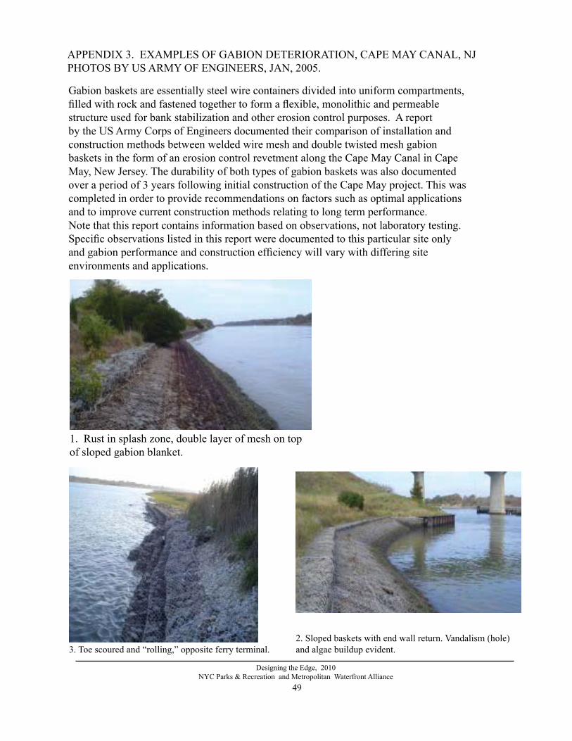
49
Designing the Edge, 2010NYC Parks & Recreation and Metropolitan Waterfront Alliance
1. Rust in splash zone, double layer of mesh on top of sloped gabion blanket.
APPENDIX 3. EXAMPLES OF GABION DETERIORATION, CAPE MAY CANAL, NJPHOTOS BY US ARMY OF ENGINEERS, JAN, 2005.
2. Sloped baskets with end wall return. Vandalism (hole) and algae buildup evident. 3. Toe scoured and “rolling,” opposite ferry terminal.
Gabion baskets are essentially steel wire containers divided into uniform compartments,filled with rock and fastened together to form a flexible, monolithic and permeablestructure used for bank stabilization and other erosion control purposes. A report by the US Army Corps of Engineers documented their comparison of installation and construction methods between welded wire mesh and double twisted mesh gabion baskets in the form of an erosion control revetment along the Cape May Canal in Cape May, New Jersey. The durability of both types of gabion baskets was also documented over a period of 3 years following initial construction of the Cape May project. This wascompleted in order to provide recommendations on factors such as optimal applicationsand to improve current construction methods relating to long term performance.Note that this report contains information based on observations, not laboratory testing. Specific observations listed in this report were documented to this particular site only and gabion performance and construction efficiency will vary with differing site environments and applications.

50
Designing the Edge, 2010NYC Parks & Recreation and Metropolitan Waterfront Alliance
4. Welded mesh splicing
5. Rust and deterioration on stepped baskets
6. Vandalism: cut mesh and stones stolen.

51
Designing the Edge, 2010NYC Parks & Recreation and Metropolitan Waterfront Alliance
REFERENCES
ASA Analysis & Communications, “A Synthesis of Literature on Shoreline Stabilization Methods and Habitat Enhancements Applicable to the Hudson River Estuary [note: freshwater portion of the estuary] prepared for Hudson River National Estuary Program. pdf format, Final Draft, Sept. 2005.
Bergfors, Robbin. personal communication. Information on use of recycled tires for shoreline structures, Dec. 2005
Curtis, William, James Clausner and Donald Stauble at ERDC, US Army Corps of Engineers emailed information about a Geosynthetic Mattress installed in Cape May Point/ Meadows in 1993, reconstructed 1997. Correspondance Jan. 2005.
Fiske, Jeffrey, Tensar Corp. Personal communication 2004-2005 regarding marine grade plastic materials.
Geissele, Gizella M., US Army Corps of Engineers, Pennsylvania. Personal communication regarding the durability of PVC-coated steel gabions over time, with different types of products, stacking design, installation methods; Information also taken from an Internal Report on Gabions along Cape May Canal, NJ by US Army Corps of Engineers Jan. 2005. Report was based on obser-vations in the field, not laboratory testing. [email protected], May, 2005
McLaren Engineering Group authors, for Dewberry-Goodking Inc. “Underwater Condition Survey,” December, 2004 for the Harlem River Bikeway and Promenade. Received at NYC Parks August, 2005.
Hepburn, Pamela, The Pegasus Preservation Project. Personal communication with NY Harbor Tugboat Captain Hepburn regarding use of recycled tires and their durability in marine environ-ments. Dec. 2004.
Herringrton, Thomas. Stevens Institute of Technology. Personal communication. Information on marine grade plastic shoreline structures. Nov. 2005-March 2006.
Thompson, William and Kim Sorvig, Sustainable Landscape Construction, Island Press, Washing-ton and California, 2000. Bioengineering illustrations from Fig. 3.1,p. 101.
Photo references:Photos on pages 50-51 are taken from an Internal Report on Gabions along Cape May Canal, NJ by US Army Corps of Engineers Jan. 2005.Community workshop photos by Keith Rodan, Greenpoint Video, 2004. Other photos are by Marcha Johnson and Ricardo Hinkle, NYC Parks except where noted.