dead run stream restoration stream team kick off august 18, 2015
TRANSCRIPT

A Fairfax County, VA, publication
Department of Public Works and Environmental Services
Working for You!
Dead Run Segments 2/3 Stream Restoration ProjectTask Force Kick-Off MeetingMcLean Government Center
August 18, 2015

2
Dead Run Segment 2/3 Stream Restoration Project
Stormwater Planning Division
Discussion Outline
• Project limits• Project identification and regulatory drivers • Project benefits • Summary of approach in current concept design• Outline of proposed approach in new concept
design• Review of completed stream restoration projects• Q&A

3
Dead Run Segment 2/3 Stream Restoration Project
Project Limits
Segment 2 – McLean Central Park• 800 Linear Feet
• Completely in Park
• Starts below previously restored section near library
Segment 3 – Dead Run Stream Valley Park• 1,500 Linear Feet
• Extends to Churchill Road
• Residential lots along Elizabeth Drive and Carol Rayes Street
Stormwater Planning Division

Dead Run Stream Restoration Project
Stormwater Planning Division
Watershed Planning and Project Implementation
• Dead Run has a drainage area just over 3 mi2
• 24 priority projects identified in the watershed management plan• Pond retrofits• LID Stormwater Enhancements• Stream Restoration• Neighborhood Stormwater
Improvements
4
http://www.fairfaxcounty.gov/dpwes/watersheds/middlepotomac.htm

Dead Run Stream Restoration Project
Stormwater Planning Division
Watershed Planning and Project Implementation
Project identified and prioritized by:• Physical conditions• Biological health• Flow and water quality data at
U.S. Geological Survey stream gage on Dead Run at Whann Ave.
• Location in watershed: Headwaters first = Upstream to Downstream
• Watershed conditions
5
http://www.fairfaxcounty.gov/dpwes/stormwater/projects/project_list.htm

Dead Run Stream Restoration Segment 2 and 3
Stormwater Planning Division
Existing Conditions
6

7Stormwater Planning Division
Dead Run Segment 2/3 Stream Restoration Project
Existing Conditions - Biological Monitoring Data

8Stormwater Planning Division
Stormwater Program Regulatory Drivers – Local TMDL

9Stormwater Planning Division
Stormwater Program Regulatory Drivers
• Virginia Stormwater Management Program (VSMP)– Municipal Separate Storm Sewer Permit (MS4)– Includes watershed planning and project implementation – Includes TMDL requirements for Chesapeake Bay and local streams
• Total Maximum Daily Loads (TMDLs)– Chesapeake Bay– Local Streams– Establishes pollutant loading budget for a given impaired water
body to meet water quality standards

10Stormwater Planning Division
Stormwater Program Regulatory Drivers – MS4 permit
Fairfax County’s MS4 Permit has requirements for the Chesapeake Bay and other (local) TMDLs – see excerpts below:

11Stormwater Planning Division
Dead Run Stream RestorationProject Benefits and Goals:• Improve water quality
– Reduce sediment and nutrient loads
• Stabilize stream banks to – Reduce stream bank erosion– Protect property– Reduce tree loss
• Improve aquatic habitat and biological health
• Restore and enhance vegetated stream buffer (riparian corridor)
• Protect infrastructure:– Sanitary Sewer– Park Trails
• Reduce frequent flooding, primarily along upper section of Segment 3

12Stormwater Planning Division
Dead Run Segment 2/3 Stream Restoration Project
Estimated water quality benefits• Chesapeake Bay Expert Panel protocols used for estimating stream
restoration nutrient credits
• For Total Phosphorus (TP) as an example the estimated reduction in loadings as a result of the proposed stream restoration for Segments 2/3 ranges from 0.063 to 0.261 lbs/LF/yr
• This compares to a ‘default’ rate of 0.068 lbs/LF/yr. The high end of the estimated load reduction is 3X the default rate
• Total annual estimated reduction in erosion for Segment 2/3 is between 783 to 1,500 tons/year and the estimated reduction in TP loading is between 190 and 788 lbs/year

13Stormwater Planning Division
Dead Run Segment 2/3 Stream Restoration Project
Estimated flood reduction levels
Modeled reduction in flood elevations range from 1.2 ft. (2-YR storm) to 0.95 ft. (100-YR storm)

14Stormwater Planning Division
Dead Run Segment 2/3 Stream Restoration Project
Overview of Approach used to Develop Current Concept
– Natural Channel Design (NCD) Approach – Reference Reach, Analytical, Regional Relationships and hydraulic analysis
– Stream Pattern, Profile and Section– Range of Values for Stable Stream Pattern– Tree Loss is Unavoidable but Provides
Opportunity to Improve Riparian Diversity

15Stormwater Planning Division
Dead Run Segment 2/3 Stream Restoration Project
Alternative Approaches – Re-walked the stream and buffer again– Priority/Option 2 and 3 Restoration Approach– Options for Refinement of the Design
• Smaller Channel Cross-section in specific areas– Transition from smaller to larger channel sections in areas,
where possible– Opportunities to save trees
• Still focus on less frequent storm events and improving the impacts of flooding especially in the Segment 3 Upper area
• Maintain overall channel stability
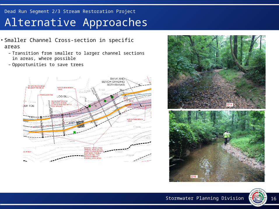
16Stormwater Planning Division
Dead Run Segment 2/3 Stream Restoration Project
Alternative Approaches
• Smaller Channel Cross-section in specific areas– Transition from smaller to larger channel sections
in areas, where possible– Opportunities to save trees

17Stormwater Planning Division
Dead Run Segment 2/3 Stream Restoration Project
Alternative Approaches – Access – Alternative 1 Approach
• Proposed some access along the left bank of the stream through Reach 3 adjacent to Elizabeth Dr.
– Alternative 2 Approach• Proposed access within the Park only, along the
sanitary sewer easement and two sections of trail. No access on private properties.
– Additional alternatives Explored• Access along sanitary sewer easement and trail. • Selecting route that has least amount of tree
impacts. Fig. 1
Fig. 2

Dead Run Segment 2/3 Stream Restoration Project
Stormwater Planning Division
Stream Buffer Restoration Potential
18

Dead Run Segment 2/3 Stream Restoration Project
Stormwater Planning Division
Chesapeake Bay Preservation Ordinance Resource Protection Area (RPA)
19
http://www.fairfaxcounty.gov/dpwes/environmental/cbay/

Dead Run Segment 2/3 Stream Restoration Project
Stormwater Planning Division
Stream Buffer Existing Conditions
20

Dead Run Segment 2/3 Stream Restoration Project
Stormwater Planning Division
Stream Buffer Restoration Potential
21
Segment 3 Stream Buffer Concept
Left Bank Left Bank Residential Residential35 foot 50 foot 35 foot 50 foot
Area (Acres) 1.14 1.55 0.46 0.87Canopy Trees 114 155 46 87Understory Trees 229 310 92 174Shrubs 1,246 1,690 501 946
Estimate tree and shrub plantings for Segment 3: Left Bank Only
Project Fact Sheets

22Stormwater Planning Division
More Information
For additional information call Dipmani Kumar, P.E., CFMProject Manager703-324-5500, TTY [email protected]/dpwes