dalraddy to slochd - transport scotland · p01 review and comment k cornwall s baungally r gunn r...
TRANSCRIPT

Dalraddy to Slochd Public Exhibition – March 2017 Summary Report
Transport Scotland
August 2017

A9 Dalraddy to Slochd Public Exhibition – March 2017 Summary Report
Atkins Mouchel Joint Venture – AMJV 1
Notice
This document and its contents have been prepared and are intended solely for Transport Scotland’s
information and use in relation to A9 Dualling.
Atkins Mouchel assumes no responsibility to any other party in respect of or arising out or in connection with
this document and/or its contents.
This document has 179 pages including the cover.
Document history
Document ref: A9P11-AMJ-GEN-X_ZZZZZ_XX-RP-SE-0005 Suitability: S3 – Review and Comment
Revision Purpose description Originated Checked Approved Authorised Date
P01 Review and comment K Cornwall S Baungally R Gunn R Gunn 29/08/2017
Client signoff
Client Transport Scotland
Project A9 Dualling Northern Section – Dalraddy to Slochd
Document title Public Exhibition March 2017 – Summary Report
Document reference A9P11-AMJ-GEN-X_ZZZZZ_XX-RP-SE-0005

A9 Dalraddy to Slochd Public Exhibition – March 2017 Summary Report
Atkins Mouchel Joint Venture – AMJV 2
Table of contents
Chapter Pages
Introduction 3
1. Exhibition Preparation 4 Advertising 4 1.1.
Exhibition Materials 4 1.2.
Photographs 6 1.3.
2. Exhibition results 8 Attendance 8 2.1.
Comments 9 2.2.
Summary 10 2.3.
Appendix A. Letter to Landowners 11
Appendix B. Exhibition poster 14
Appendix C. Press advertisement 16
Appendix D. Press coverage 18
Appendix E. Exhibition display boards 21
Appendix F. Exhibition leaflet 39
Appendix G. Feedback form 48
Appendix H. Comments 52
Table of Figures
Figure 2-1 Attendance map 8 Figure 2-2 Exhibition comments summary 9

A9 Dalraddy to Slochd Public Exhibition – March 2017 Summary Report
Atkins Mouchel Joint Venture – AMJV 3
Introduction
Transport Scotland is progressing a programme to upgrade the A9 trunk road between Perth and Inverness to
dual carriageway standard.
The delivery of the A9 Dualling Northern Section, Dalraddy to Inverness, forms part of this commitment. The
Northern Section is subdivided into two projects for the purposes of design and statutory approvals:
• Dalraddy to Slochd; and
• Tomatin to Moy
In March 2017, as part of these proposals, a public exhibition was held in two locations on two separate days to
update interested parties on progress of the Dalraddy to Slochd project. The aim of the exhibition was to engage
with the public and give local communities and road users the opportunity to see and comment on the outcome
of the route option assessment work and the preferred option for the Dalraddy to Slochd Dualling project.
The exhibition visited Aviemore Community Centre on Thursday 2nd
March 2017 before moving on to Carrbridge
Village Hall on Friday 3rd
March 2017. On both days, the exhibition was open to the public from 12.00pm to
8.00pm.
The exhibition was well attended with 248 attendees across the two days. This report summarises the scope of
the event and the reactions and comments of those who attended.

A9 Dalraddy to Slochd Public Exhibition – March 2017 Summary Report
Atkins Mouchel Joint Venture – AMJV 4
1. Exhibition Preparation
Advertising 1.1.
In advance of the exhibition, letters of invitation were sent to residents, landowners, businesses and their staff,
stakeholders and stakeholder organisations, either within the A9 Dalraddy to Slochd road corridor or otherwise
likely to be affected by the proposals.
Dependent on the recipient, the letters also included offers of individual face-to-face meetings, presentations to
community groups or contact details for further information.
In total, 966 letters of invitation were issued. Of these, 332 were sent to landowners, businesses and their staff,
stakeholders and stakeholder organisations. The remaining 634 letters were sent to residents. An example of
the letter issued to landowners is included in Appendix A.
In addition, 71 posters advertising the event were distributed around post offices, churches, village halls,
community centres, shops, libraries, schools and leisure facilities. These establishments were located in
Inverness, Aviemore, Kincraig, Grantown on Spey, Dulnain Bridge, Boat of Garten, Carrbridge, Nethy Bridge
and Tomatin. A copy of the poster is included in Appendix B.
A series of advertisements publicising the event appeared in the Inverness Courier, The Press and Journal and
the Strathspey and Badenoch Herald newspapers between mid-February and early March 2017. Articles
reporting on the exhibition were included in the 3rd
March edition of the Press and Journal and the 9th March
edition of the Strathspey and Badenoch Herald. A copy of the newspaper advertisement is included in Appendix
C and the press articles in Appendix D.
Exhibition Materials 1.2.
The exhibition material presented at the public exhibitions consisted of:
Exhibition leaflet - A9 Dualling Dalraddy to Slochd Exhibition project: Preferred option March 2017
Exhibition display boards (16 No)
Drawings:
o Preferred Route Alignment Aerial Overview Plan 1:2500 (Sheets 1 to 9)
o Preferred Route Option 1:5000 (Sheets 1 to 8)
o Preferred Route Strip Plans (Sheets 1 to 3)
Feedback form
1.2.1. Exhibition Boards
Information relating to the scheme was presented on a number of display boards. The heading of each board is
given below:
1. Dalraddy to Slochd project - welcome
2. Programme objectives
3. Project development

A9 Dalraddy to Slochd Public Exhibition – March 2017 Summary Report
Atkins Mouchel Joint Venture – AMJV 5
4. Consultation
5. Stage 2 – preferred option overview
6. Stage 2 – preferred option summary
7. Preferred option: mainline
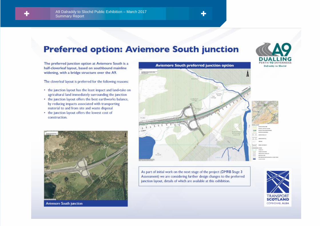
8. Preferred option: Aviemore South junction
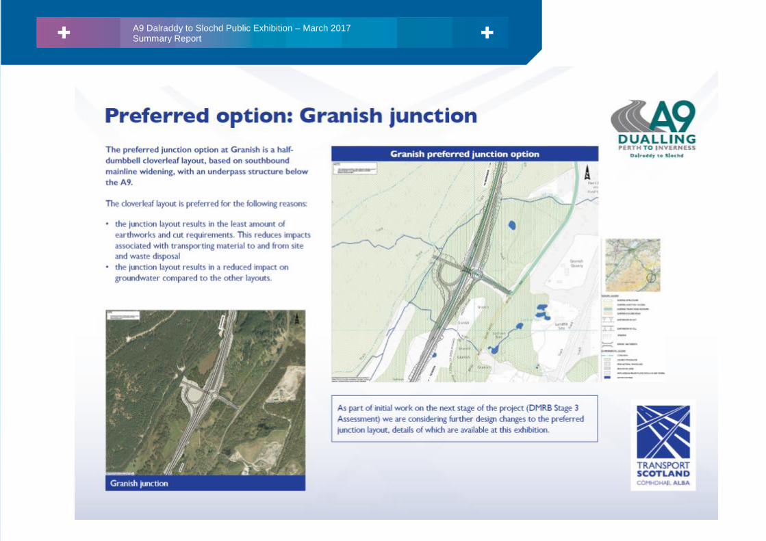
9. Preferred option: Granish junction
10. Preferred option: Black Mount junction
11. Stage 2 option assessment – preferred option 1 of 3
12. Stage 2 option assessment – preferred option 2 of 3
13. Stage 2 option assessment – preferred option 3 of 3
14. Stage 3 –further design development
15. What happens next?
16. Comments and feedback
The exhibition display boards can be found in Appendix E.
1.2.2. Drawings
Copies of the drawings listed above were available on layout tables for viewing at the exhibition.
1.2.3. Exhibition Leaflet
A copy of the A9 Dualling Dalraddy to Slochd March 2017 leaflet was handed to each visitor to the exhibition. A
copy of the leaflet can be found in Appendix F.
1.2.4. Feedback Form
A feedback form was handed to each visitor to the exhibition. Visitors were invited to leave their comments in an
exhibition ‘post box’ at the venue. Alternatively, comments on the proposals were requested by email or post
before Friday 14th April 2017. A copy of the feedback form can be found in Appendix G.
1.2.5. Information Sources Following Exhibition
The exhibition display boards, drawings, A9 Dualling Dalraddy to Slochd exhibition leaflet and feedback form
were made available to download from the A9 Dualling section of the Transport Scotland website at the
following web address:
https://www.transport.gov.scot/projects/a9-dualling-perth-to-inverness/a9-dalraddy-to-slochd/

A9 Dalraddy to Slochd Public Exhibition – March 2017 Summary Report
Atkins Mouchel Joint Venture – AMJV 6
Photographs 1.3.
1.3.1. The exhibition venue, Aviemore Community Centre, 2nd March 2017
1.3.2. The exhibition venue, Carrbridge Village Hall, 3rd March 2017

A9 Dalraddy to Slochd Public Exhibition – March 2017 Summary Report
Atkins Mouchel Joint Venture – AMJV 7
1.3.3. Visitors to the exhibition

A9 Dalraddy to Slochd Public Exhibition – March 2017 Summary Report
Atkins Mouchel Joint Venture – AMJV 8
2. Exhibition results
Attendance 2.1.
The exhibition was well attended with a total of 248 visitors over the course of the two days, with 127 attending
on March 2nd
and 121 on March 3rd
.
Visitors were asked to complete a sign-in sheet on arrival at the exhibition. Most visitors (97%) complied with a
request to provide their home postcode. An analysis of this information shows that the majority of visitors were
from the Aviemore and Carrbridge postcode areas, the geographic spread being generally as shown below.
Figure 2-1 Attendance map
28%
5%
6%
43%
7%
2%
4%

A9 Dalraddy to Slochd Public Exhibition – March 2017 Summary Report
Atkins Mouchel Joint Venture – AMJV 9
Comments 2.2.
Visitors to the exhibition were encouraged to provide feedback to help inform the future development of the
project. Comments were sought on the junction options and access arrangements, including the effects of
potential closures.
A total of 73 returns were received; a combination of feedback forms left on the day(s) (24), completed on line
(4), submitted by post (9) and comments sent to the project email address (36).
Key areas of feedback and comments received focused on: mainline widening (in particular as the A9 passes
the settlement of Aviemore), junction layouts, non-motorised users (NMUs) and local access arrangements.
In order to present a summary of visitors’ observations and concerns, the comments received have been
grouped into thirteen categories, as shown in Figure 2-2 below.
Details of the feedback received and responses are included in Appendix H.
Figure 2-2 Exhibition comments summary

A9 Dalraddy to Slochd Public Exhibition – March 2017 Summary Report
Atkins Mouchel Joint Venture – AMJV 10
Summary 2.3.
The A9 Dualling Dalraddy to Slochd Public Exhibition held on 2nd
and 3rd
March 2017 provided details for the
outcome of the route option assessment work and announced the preferred route for the project. This included
details of mainline widening, preferred junction layouts and details of different junction layouts being considered
as part of the next stage of design. It provided an opportunity for members of the public to discuss the scheme
with Transport Scotland representatives and their consultants.
The exhibitions were advertised locally and on the Transport Scotland website and both events were well
attended. The exhibition venues were satisfactory and having a set-aside area for landowners or other
stakeholders requiring a meeting in private proved to be as useful as it had been at previous events. Holding the
exhibition over two days allowed increased accessibility and was considered a successful arrangement.
The feedback received from the exhibitions is now being used by Transport Scotland and their consultants to
inform the ongoing development of the scheme.

A9 Dalraddy to Slochd Public Exhibition – March 2017 Summary Report
Atkins Mouchel Joint Venture – AMJV 11
Appendix A. Letter to Landowners

A9 Dalraddy to Slochd Public Exhibition – March 2017 Summary Report
Atkins Mouchel Joint Venture – AMJV 12

A9 Dalraddy to Slochd Public Exhibition – March 2017 Summary Report
Atkins Mouchel Joint Venture – AMJV 13

A9 Dalraddy to Slochd Public Exhibition – March 2017 Summary Report
Atkins Mouchel Joint Venture – AMJV 14
Appendix B. Exhibition poster

A9 Dalraddy to Slochd Public Exhibition – March 2017 Summary Report
Atkins Mouchel Joint Venture – AMJV 15

A9 Dalraddy to Slochd Public Exhibition – March 2017 Summary Report
Atkins Mouchel Joint Venture – AMJV 16
Appendix C. Press advertisement

A9 Dalraddy to Slochd Public Exhibition – March 2017 Summary Report
Atkins Mouchel Joint Venture – AMJV 17

A9 Dalraddy to Slochd Public Exhibition – March 2017 Summary Report
Atkins Mouchel Joint Venture – AMJV 18
Appendix D. Press coverage

A9 Dalraddy to Slochd Public Exhibition – March 2017 Summary Report
Atkins Mouchel Joint Venture – AMJV 19

A9 Dalraddy to Slochd Public Exhibition – March 2017 Summary Report
Atkins Mouchel Joint Venture – AMJV 20

A9 Dalraddy to Slochd Public Exhibition – March 2017 Summary Report
Atkins Mouchel Joint Venture – AMJV 21
Appendix E. Exhibition display boards

A9 Tomatin to Moy Public Exhibition – November 2016 Summary Report
Atkins Mouchel Joint Venture – AMJV 22

A9 Tomatin to Moy Public Exhibition – November 2016 Summary Report
Atkins Mouchel Joint Venture – AMJV 23

A9 Tomatin to Moy Public Exhibition – November 2016 Summary Report
Atkins Mouchel Joint Venture – AMJV 24

A9 Tomatin to Moy Public Exhibition – November 2016 Summary Report
Atkins Mouchel Joint Venture – AMJV 25

A9 Tomatin to Moy Public Exhibition – November 2016 Summary Report
Atkins Mouchel Joint Venture – AMJV 26

A9 Dalraddy to Slochd Public Exhibition – March 2017 Summary Report
Atkins Mouchel Joint Venture – AMJV 27

A9 Dalraddy to Slochd Public Exhibition – March 2017 Summary Report
Atkins Mouchel Joint Venture – AMJV 28
A9 Dalraddy to Slochd Public Exhibition – March 2017 Summary Report
Atkins Mouchel Joint Venture – AMJV 29
A9 Dalraddy to Slochd Public Exhibition – March 2017 Summary Report
Atkins Mouchel Joint Venture – AMJV 30

A9 Dalraddy to Slochd Public Exhibition – March 2017 Summary Report
Atkins Mouchel Joint Venture – AMJV 31

A9 Tomatin to Moy Public Exhibition – November 2016 Summary Report
Atkins Mouchel Joint Venture – AMJV 32

A9 Tomatin to Moy Public Exhibition – November 2016 Summary Report
Atkins Mouchel Joint Venture – AMJV 33

A9 Dalraddy to Slochd Public Exhibition – March 2017 Summary Report
Atkins Mouchel Joint Venture – AMJV 34

A9 Tomatin to Moy Public Exhibition – November 2016 Summary Report
Atkins Mouchel Joint Venture – AMJV 35
A9 Tomatin to Moy Public Exhibition – November 2016 Summary Report
Atkins Mouchel Joint Venture – AMJV 36

A9 Tomatin to Moy Public Exhibition – November 2016 Summary Report
Atkins Mouchel Joint Venture – AMJV 37

A9 Dalraddy to Slochd Public Exhibition – March 2017 Summary Report
Atkins Mouchel Joint Venture – AMJV 38

A9 Tomatin to Moy Public Exhibition – November 2016 Summary Report
Atkins Mouchel Joint Venture – AMJV 39
Appendix F. Exhibition leaflet

A9 Dalraddy to Slochd Public Exhibition – March 2017 Summary Report
Atkins Mouchel Joint Venture – AMJV 40

A9 Dalraddy to Slochd Public Exhibition – March 2017 Summary Report
Atkins Mouchel Joint Venture – AMJV 41

A9 Dalraddy to Slochd Public Exhibition – March 2017 Summary Report
Atkins Mouchel Joint Venture – AMJV 42

A9 Dalraddy to Slochd Public Exhibition – March 2017 Summary Report
Atkins Mouchel Joint Venture – AMJV 43

A9 Dalraddy to Slochd Public Exhibition – March 2017 Summary Report
Atkins Mouchel Joint Venture – AMJV 44

A9 Dalraddy to Slochd Public Exhibition – March 2017 Summary Report
Atkins Mouchel Joint Venture – AMJV 45

A9 Dalraddy to Slochd Public Exhibition – March 2017 Summary Report
Atkins Mouchel Joint Venture – AMJV 46

A9 Dalraddy to Slochd Public Exhibition – March 2017 Summary Report
Atkins Mouchel Joint Venture – AMJV 47

A9 Dalraddy to Slochd Public Exhibition – March 2017 Summary Report
Atkins Mouchel Joint Venture – AMJV 48
Appendix G. Feedback form

A9 Dalraddy to Slochd Public Exhibition – March 2017 Summary Report
Atkins Mouchel Joint Venture – AMJV 49

A9 Dalraddy to Slochd Public Exhibition – March 2017 Summary Report
Atkins Mouchel Joint Venture – AMJV 50

A9 Dalraddy to Slochd Public Exhibition – March 2017 Summary Report
Atkins Mouchel Joint Venture – AMJV 51

A9 Dalraddy to Slochd Public Exhibition – March 2017 Summary Report
Atkins Mouchel Joint Venture – AMJV 52
Appendix H. Comments

A9 Dalraddy to Slochd Public Exhibition – March 2017 Summary Report
Atkins Mouchel Joint Venture – AMJV 53
Reference Comment Response
Aviemore_001 Aviemore to Carrbridge - Granish
The current A95, bearing an inordinate number of HGVs, has lorries stop
to turn right up a significant slope. When this junction was altered a
number of years ago, The Scottish office failed to take this into
consideration, making the B9152 the priority rather than the A95. This is
still the same arrangement in the current proposal.
The A95 going south should be the priority road and should be graded to
allow lorries to approach A9 at a gentler slope and less of an angle.
Following the A9 Dualling Dalraddy to Slochd public exhibition in
Aviemore and Carrbridge in March 2017 and the closing of the
consultation period, thank you for taking the time to provide
comments. We would also like to thank-you for your attendance at
these exhibitions.
With regards to the Granish junction and its connection with the side
road network, specifically the A95 and B9152, traffic data indicates
that the predominant traffic flow is along the A95/B9152. However,
we are aware of and have received comprehensive feedback with
respect to HGV movements which make up a large percentage of the
A95/A9 traffic turning movements at this junction. Accordingly, this
connection is subject to further development during DMRB Stage 3
which will take account of traffic flows, accident data, traffic
composition and constraints. Proposals on the layout and
configuration of these connections will be made available at the next
public consultation event in autumn 2017.
With regards to the side road gradients the proposals for the
connection from A95/B9152 to the A9 show this connection link going
under the A9. The gradient of the existing link will be reduced
(flattened out) under the proposals in order to achieve an
underbridge crossing of the A9.
Aviemore_002 Dalraddy to Aviemore. South option
Having gone for the option to cross the field, I’m very disappointed to see
the preferred option is a junction on the B9152 through ancient
woodland.
The preferred option to the south shows a proposed roundabout
Following the A9 Dualling Dalraddy to Slochd public exhibition in
Aviemore and Carrbridge in March 2017 and the closing of the
consultation period, thank you for taking the time to provide
comments. We would also like to thank-you for your attendance at
these exhibitions.

A9 Dalraddy to Slochd Public Exhibition – March 2017 Summary Report
Atkins Mouchel Joint Venture – AMJV 54
Reference Comment Response
connecting traffic coming into Aviemore with traffic looking to go south.
If this roundabout was changed to allow access from B9152 to come off
the existing junction to the A9 to come across a field to the new
roundabout, this allows traffic coming from Kincraig easier access and
traffic from A9 north easier access to Aviemore.
We note your comments regarding the Aviemore South junction
regarding the ancient woodland. On balance of impacts from all
options assessed at Stage 2, the small loss of Ancient Woodland was
found to be minimal and where necessary compensatory planting
would be promoted to offset any potential loss. In addition to this,
overall the Stage 2 Aviemore South junction was identified as
preferred for the following reasons:
the junction layout has the least impact and land-take on
agricultural land immediately surrounding the junction
the junction layout offers the best earthworks balance, by
reducing impacts associated with transporting material to and
from site and waste disposal
the junction layout offers the lowest cost of construction
However, as part of our Stage 3 design development we will be
working to minimise, and where appropriate mitigate, losses and
impacts to ancient woodland.
You also commented on, and suggested alternatives to, the layout and
location of the Aviemore South Junction preferred option. Please note
the public exhibition in March presented the DMRB Stage 2 preferred
junction options.
As part of the ongoing design development during DMRB Stage 3, we
are considering how to apply design changes to accommodate a
smaller junction layout, as shown at the exhibitions.
You make comment that the preferred junction option, “to the south
shows a proposed roundabout”. Please note that the preferred
junction option at Aviemore South is a half-cloverleaf layout which
caters for all turning movements to and from the A9 dual carriageway

A9 Dalraddy to Slochd Public Exhibition – March 2017 Summary Report
Atkins Mouchel Joint Venture – AMJV 55
Reference Comment Response
via dedicated slip roads. The mainline within the extents of the
junction is based on southbound widening, with a bridge structure
taking the link road over the A9.
Aviemore_003 Aviemore
This “preferred” option seems not to have been thought through
properly. The impact on Milton woods, Aviemore would be devastating.
Already we have lost a sizeable chunk of the woods with the construction
of the water main. Widening on the south side here would mean the
water main would need to be moved again, involving greater expenditure
and probably eradicating more of what is a small gem. Along with the
new carriageway would wood be left? This wood is widely used by locals
and tourists and has many rare varieties of wild flower along with cover
for deer and red squirrels living in the woods. Surely it would be more
sensible to construct the new carriageway behind Aviemore northbound,
as already there is a space due to the Tulloch houses being built. Also,
where can the carriageway go behind Macdonald Hotel? Already the
road is practically sitting on top of the hotel. Surely making temporary
crossovers during construction is a small price to pay for an eventual
outcome of saving the villages precious woodland?
Following the A9 Dualling Dalraddy to Slochd public exhibition in
Aviemore and Carrbridge in March 2017 and the closing of the
consultation period, thank you for taking the time to provide
comments. We would also like to thank-you for your attendance at
these exhibitions.
We note that you sent two pieces of feedback under separate cover.
We have addressed both in this response.
Your comments with regards to southbound carriageway widening in
the vicinity of Aviemore and Milton Wood have been noted, as has
your suggestion to widen the carriageway to the northbound side of
the existing A9.
Widening on the northbound carriageway (where you have noted that
there is more open space) would result in encroachment into
Craigellachie National Nature Reserve (NNR) and Site of Special
Scientific Interest (SSSI). This site has been designated for its wildlife
interest at a UK level and is nationally important for upland birch
woodland and its moth assemblage. The reserve is well-visited (in the
region of 8,500 visitors per year according to Scottish Natural
Heritage) and acts as an important visitor attraction. Furthermore, it
has been identified that there are environmental and constructability
issues associated with widening into Loch Pulladern, which is located
immediately to the northbound side of the existing A9 and is part of
the SSSI and NNR.

A9 Dalraddy to Slochd Public Exhibition – March 2017 Summary Report
Atkins Mouchel Joint Venture – AMJV 56
Reference Comment Response
Notwithstanding the above, the preferred route has been selected in
order to obtain a balance that minimises impacts on the NNR/SSSI and
to avoid direct impacts on residential buildings. Additionally, mainline
option 1a provides the best overall earthworks balance and has a
lower number of crossovers, simplifying construction and therefore
minimising disruption to road users and adjacent communities.
We note your comments regarding flora and fauna within the Milton
Woods and the potential impacts on them. These ecological aspects
form part of our Environmental Impact Assessment (EIA) during
Design Manual for Roads and Bridges (DMRB) Stage 3 and have
additionally been considered during all our assessments to date
throughout DMRB Stage 2. During the EIA, surveyors carrying out a
wide variety of ecology surveys such as red squirrel, pine marten,
national vegetation classification (NVC), trees and other surveys. This
work will culminate in the publication of the draft Environmental
Statement which the public will be able to view and comment on. The
Environmental Impact Assessment will also identify the need for any
mitigation and this may be undertaken by means such as planting and
landscaping / landform.
With regards to the water main in the vicinity of the A9 as it passes
Aviemore, we can confirm that we are aware of this physical
constraint and we are consulting with Scottish Water with respect to
their utility apparatus to understand where diversion and / or
protection may be required. During the Design Manual for Roads and
Bridges (DMRB) Stage 3 assessment, we are looking to refine the
design and minimise impacts on this and other utilities where
possible.
We have noted the non-motorised user (NMU) access that you have

A9 Dalraddy to Slochd Public Exhibition – March 2017 Summary Report
Atkins Mouchel Joint Venture – AMJV 57
Reference Comment Response
identified (the cattle creep to access the woodlands at High Burnside).
Your feedback in this regard is valuable and will be helpful to
informing the detailed design and assessment of NMU provisions for
the Dalraddy to Slochd project, as part of the Design Manual for Roads
and Bridges (DMRB) Stage 3 assessment. We expect to be able to
report on our initial work with regards to NMU provision at the next
round of public engagement events planned for autumn of 2017. We
will also be consulting with various NMU groups during DMRB Stage 3
which encompass walking, cycling and equestrian users.
Aviemore_004 1. The preferred general widening on the southbound side does not take
into account the need to relocate at least one mile of the main water
pipeline serving Aviemore.
2. The additional carriageway on the southbound side also interferes
with the large LPG installation serving the Macdonald Resort. These
two items will result in a significant cost increase for this option.
3. Adding an extra carriageway on the southbound side will also lead to
a need to move more material to build up embankments than would
be the case if the northbound carriageway was widened.
4. Why is there such antipathy to changing the side to which the
widening is done? It hasn’t caused that much hassle with the
Dalraddy/Kincraig stretch?
5. What arrangements will be put in place to protect the railway at
Kinveachy where road and rail approach closely. Widening on the
Northbound side would eliminate that problem (and again reduce
costs!)
Following the A9 Dualling Dalraddy to Slochd public exhibition in
Aviemore and Carrbridge in March 2017 and the closing of the
consultation period, thank you for taking the time to provide
comments. We would also like to thank-you for your attendance at
these exhibitions.
Taking each of your points in turn in your first response:
1. With regards to the water main in the vicinity of the A9 as it passes
Aviemore, we can confirm that we are aware of this physical
constraint and that this was taken into account in arriving at the
preferred option selection during Design Manual for Roads and
Bridges (DMRB) Stage 2. We are consulting with Scottish Water
with respect to their utility apparatus to understand where
diversion and / or protection may be required.
2. Similarly, with regards to the liquefied petroleum gas (LPG)
installation in the vicinity of the A9 as it passes Aviemore, we can
confirm that we are aware of this physical constraint and that this
was taken into account in arriving at the preferred option selection
at DMRB Stage 2. We are consulting with the landowner with

A9 Dalraddy to Slochd Public Exhibition – March 2017 Summary Report
Atkins Mouchel Joint Venture – AMJV 58
Reference Comment Response
respect to their utility apparatus to understand where diversion
and / or protection may be required. During the DMRB Stage 3
assessment, we are looking to refine the design and minimise
impacts on this, the Scottish Water main and other utilities where
possible. Your comments regarding the costs associated with each
of these utilities has been noted. The preferred main line option is
subject to detailed assessments during DMRB Stage 3 against the
criteria of engineering, traffic, environment, as well as economics.
Accordingly, the detailed assessments described previously will
also consider the comparable costs associated with each of the
options.
3. We note your comments regarding the preferred mainline option,
particularly in relation to construction requirements. Mainline
option 1a provides the best overall earthworks balance, which
considers the overall cut and fill requirements of the project.
Where possible, an earthworks balance would be targeted in order
to reduce the impacts associated with transporting material to and
from the site and waste disposal. The preferred route also has a
lower number of carriageway crossovers, which offers a number of
benefits including: simplifying construction and therefore
minimising disruption including traffic delays to road users,
reduction in construction duration, reduction in construction costs
and a safer working environment for the construction workforce.
4. We note your comments regarding the preferred mainline option
between Kincraig and Dalraddy. Pease note that the Dalraddy to
Slochd projects presents a unique set of challenges and
constraints, and as such engineering and construction issues are
unique to each of the A9 dualling projects. Option 1a is preferred

A9 Dalraddy to Slochd Public Exhibition – March 2017 Summary Report
Atkins Mouchel Joint Venture – AMJV 59
Reference Comment Response
as it:
avoids direct impacts on residential properties
has the least impact on Craigellachie Site of Special Scientific
Interest (SSSI) and National Nature Reserve (NNR)
has the least impact on Alvie SSSI
has a lower number of crossovers during construction,
simplifying construction and traffic management
best overall earthworks balance by reducing impacts
associated with transporting material to and from site and
waste disposal
Furthermore, it has been identified that there are environmental
and constructability issues associated with widening into Loch
Pulladern, which is located immediately to the northbound side of
the existing A9 and is part of the SSSI and NNR.
5. With regards to your comment about the railway at Kinveachy we
confirm that we are working with Network Rail with respect to any
works adjacent to the Highland Mainline Railway. There are strict
processes and procedures that are required in order to ensure the
safety of rail operations.
Aviemore_005 Aviemore South Junction and Passing Aviemore. Have you allowed for
2000 cars/hour going skiing and into Glenmore and Rothiemuchus? Are
you considering replacement and new trees for noise screening for this
otherwise quiet environment - noting echo of the cliffs. Very good
consultation, presentation and assistance.
Thank you.
Following the A9 Dualling Dalraddy to Slochd public exhibition in
Aviemore and Carrbridge in March 2017 and the closing of the
consultation period, thank you for taking the time to provide
comments. We would also like to thank-you for your attendance at
these exhibitions.
With regards to the Aviemore South junction and traffic numbers,
both the Design Manual for Roads and Bridges (DMRB) Stage 2
preferred junction and DMRB Stage 3 design development junction

A9 Dalraddy to Slochd Public Exhibition – March 2017 Summary Report
Atkins Mouchel Joint Venture – AMJV 60
Reference Comment Response
(which was also on display at the exhibition) allow for forecasted
future traffic movements. All of the junctions selected have been
subject to traffic modelling to assess how the junction layout
performs and accommodates the turning movements at the time of
the scheme opening and at a future date of 15 years post opening. In
addition to the traffic modelling, a detailed assessment against criteria
under the headings of environment, engineering and economics has
been undertaken to ensure a robust assessment was completed.
During DMRB Stage 3 a detailed assessment of operational noise
levels, involving computer modelling and using the projected traffic
flow data, will be carried out once the preferred option detailed
design is sufficiently developed. An assessment of temporary noise
impacts arising from construction activity will also be undertaken.
Appropriate noise mitigation measures will be identified, where
required, and options might include noise barriers or earth bunds, in
addition to embedded mitigation in the form of lower noise road
surfaces. An Environmental Impact Assessment will be undertaken as
part of DMRB Stage 3 and the outcomes of this and details of any
essential noise mitigation will be reported in the Environmental
Statement.
Building on the visual impact assessment which was undertaken as
part of DMRB Stage 2, a detailed assessment of the refined preferred
option will be carried out during DMRB Stage 3. The DMRB Stage 3
assessment will include the development of detailed and specific
mitigation measures relating to both construction (e.g. screening and
minimisation of artificial lighting) and operational (e.g. tree planting
and sensitive slope profiling to achieve best ‘landscape fit’) phases. As
mentioned previously with regards to noise, an Environmental Impact

A9 Dalraddy to Slochd Public Exhibition – March 2017 Summary Report
Atkins Mouchel Joint Venture – AMJV 61
Reference Comment Response
Assessment will be undertaken as part of DMRB Stage 3 and the
outcomes of this and details of any essential visual mitigation will be
reported in the Environmental Statement.
Aviemore_006 I am happy overall with the decision to widen to the southbound c/w.
However, I would ask that in light of the growth of mountain biking in the
last few years in the area, and the importance of the sport for the local
economy, provision be made for a number of suitable crossings for bike
riders, and slower other uses such as horse riders. The popularity of MTB
trails in the area above high Burnside, Aviemore, requires particular
consideration. Many families ride these trails and need a safe crossing
back to the Route 7 cycle path
Following the A9 Dualling Dalraddy to Slochd public exhibition in
Aviemore and Carrbridge in March 2017 and the closing of the
consultation period, thank you for taking the time to provide
comments.
Thank-you for your comments with respect to the preferred mainline
widening option 1a. This option is preferred as it:
avoids direct impacts on residential properties
has the least impact on Craigellachie Site of Special Scientific
Interest (SSSI) and National Nature Reserve (NNR)
has the least impact on Alvie SSSI
has a lower number of crossovers during construction, simplifying
construction and traffic management
best overall earthworks balance by reducing impacts associated
with transporting material to and from site and waste disposal
We have noted your request for suitable non-motorised user (NMU)
crossings around Aviemore. Your feedback in this regard is valuable
and will be helpful to informing the detailed design and assessment of
NMU provisions for the Dalraddy to Slochd project, as part of the
Design Manual for Roads and Bridges (DMRB) Stage 3 assessment. We
expect to be able to report on our initial work with regards to NMU
provision at the next round of public engagement events planned for
autumn 2017. We will also be consulting with various NMU groups
during DMRB Stage 3 which encompass walking, cycling and
equestrian users.

A9 Dalraddy to Slochd Public Exhibition – March 2017 Summary Report
Atkins Mouchel Joint Venture – AMJV 62
Reference Comment Response
Aviemore_007 As well as number of vehicles using the junctions North and South of
Aviemore, the weather conditions and experience of drivers into a
holiday area should be taken into account. 24-hour fuel, snow showers
and freezing conditions November to April and a lot of visiting drivers not
used to driving on snow or icy roads. It will not be possible to keep the
junctions gritted and there could be a risk of vehicles sliding off the
turning road, causing the exit and entrances to the A9 to be blocked.
Experience here is that it only takes a small amount of snow on an icy
road for inexperienced drivers to skid. Also, small accidents are not
reported to the police.
Following the A9 Dualling Dalraddy to Slochd public exhibition in
Aviemore and Carrbridge in March 2017 and the closing of the
consultation period, thank you for taking the time to provide
comments.
We note your comments with respect to vehicle movements at
junctions, particularly during periods of inclement and winter
weather. We confirm that the safe use and operation of the road is a
key consideration in developing the scheme proposals and we confirm
that design is being undertaken in accordance with the national
Design Manual for Roads and Bridges (DMRB) standards. We also
confirm that we are consulting closely with both the Trunk Road
Operating Company and The Highland Council both with respect to
design and the future operation and maintenance following dualling
of the A9 to ensure that a safe and resilient solution is provided.
Aviemore_008 I recently attended the public exhibition at Aviemore community hall on
the 2 March.
It became apparent that your department is under the impression that
Scandinavian Village Limited (SVL) is part of the Macdonald Hotel
Consortium. This is certainly not the case as SVL has a 100 year lease
which has 67 years remaining.
SVL is a Timeshare Resort with 2950 weeks which were available for
purchase to the general public. The resort was constructed in 1982 and is
sold out and therefore owned by the members of the association of
which we have approximately 2,600 owners - some own more than 1
week.
I find it incredulous that Transport Scotland have not contacted the
Following the A9 Dualling Dalraddy to Slochd public exhibition in
Aviemore and Carrbridge in March 2017 and the closing of the
consultation period, thank you for taking the time to provide
comments. We would also like to thank-you for your attendance at
these exhibitions.
Thank-you for bringing to our attention the nature of Scandinavian
Village Limited (SVL)’s lease with respect to Macdonald Hotels. We
will update our records accordingly and now that we have established
the information with regards to Scandinavian Village Limited, we look
forward to engaging with you throughout Design Manual for Roads
and Bridges (DMRB) Stage 3.
Please note that the events were well advertised, with event posters

A9 Dalraddy to Slochd Public Exhibition – March 2017 Summary Report
Atkins Mouchel Joint Venture – AMJV 63
Reference Comment Response
resort management for their input to be taken into consideration when
this project was first put forward.
With regards to the effect the project will have to SVL owners, my
concern is the increase in noise level during the construction and later
with the traffic being close to the SVL boundary fence once the dual
carriageway is widened at the west side of the Village.
The noise level at present has been extenuated by the removal of the
trees along the full length of the boundary fence by the Scottish Water
during the laying of the new water pipes system around Aviemore. The
water main is 4 meters from our boundary and 26 meters from the duel
carriageway. When the plans were submitted, they agreed to reinstate
the trees which they have since refused to do.
I am concerned the same result will take place, and that SVL views will
simply be ignored yet again.
I believe a sound barrier will be required before the construction begins,
this would minimize the disruption to our owners, who come to
Aviemore for a quiet and peaceful holiday experience.
We would be willing for a tree line barrier to be formed on the north and
west sides to be inside our boundary fence line. This would act as a
natural sound barrier to minimize the noise before and after
construction.
issued to the Macdonald Hotel in Aviemore, as well as shops,
churches, libraries and schools through towns and villages in the
Badenoch and Strathspey area. AMJV / TS also sent an invite via email
to the [email protected] email address on the 21st
February 2017, requesting that this be circulated to all of your
members.
We have noted your comments with regards to noise, particularly in
respect of SVL’s owners during construction and your request for
some form of noise attenuation. We can advise that during DMRB
Stage 3 a detailed assessment of operational noise levels, involving
computer modelling and using the projected traffic flow data, will be
carried out once the preferred option detailed design is sufficiently
developed. An assessment of temporary noise impacts arising from
construction activity will also be undertaken. Appropriate noise
mitigation measures will be identified, where required, and options
may include noise barriers or earth bunds, in addition to embedded
mitigation in the form of lower noise road surfaces. An Environmental
Impact Assessment will be undertaken as part of DMRB Stage 3 and
the outcomes of this and details of any essential noise mitigation will
be reported in the Environmental Statement.
We acknowledge your willingness for a tree barrier to be formed
inside the Scandinavian Village boundary and we will discuss both
mitigation and accommodation works with you further as the scheme
details develop.
Aviemore_009 I attended the public exhibition for the Dalraddy to Sloch project in
Aviemore on Thursday 2nd March 2017. My concerns and worries, which I
notified you about at an earlier date, were lifted when I saw the
Following the A9 Dualling Dalraddy to Slochd public exhibition in
Aviemore and Carrbridge in March 2017 and the closing of the
consultation period, thank you for taking the time to provide

A9 Dalraddy to Slochd Public Exhibition – March 2017 Summary Report
Atkins Mouchel Joint Venture – AMJV 64
Reference Comment Response
preferred route option. I look forward to seeing future development and
wish you luck. Many thanks to your team who were most helpful and
professional.
comments. We would also like to thank-you for your attendance at
these exhibitions.
Thank-you for your positive comments with respect to the staff
present at the event, we are glad that you found the information
helpful.
We would also like to thank-you for your positive comments in
support of the preferred mainline widening option 1a. This option is
preferred as it:
avoids direct impacts on residential properties
has the least impact on Craigellachie Site of Special Scientific
Interest (SSSI) and National Nature Reserve (NNR)
has the least impact on Alvie SSSI
has a lower number of crossovers during construction, simplifying
construction and traffic management
best overall earthworks balance by reducing impacts associated
with transporting material to and from site and waste disposal
Aviemore_010 1. Southern route widening as proposed is preferred.
2. Agree with northbound widening at Loch Alvie and Avie Lochan.
3. Prefer smaller footprint options to junctions around Aviemore.
4. Would like current footpath underpass at High Burnside, Aviemore to
be retained.
Following the A9 Dualling Dalraddy to Slochd public exhibition in
Aviemore and Carrbridge in March 2017 and the closing of the
consultation period, thank you for taking the time to provide
comments. We would also like to thank-you for your attendance at
these exhibitions.
Thank-you for your positive comments in support of the preferred
mainline widening option 1a. This option is preferred as it:
avoids direct impacts on residential properties
has the least impact on Craigellachie Site of Special Scientific
Interest (SSSI) and National Nature Reserve (NNR)

A9 Dalraddy to Slochd Public Exhibition – March 2017 Summary Report
Atkins Mouchel Joint Venture – AMJV 65
Reference Comment Response
has the least impact on Alvie SSSI
has a lower number of crossovers during construction, simplifying
construction and traffic management
best overall earthworks balance by reducing impacts associated
with transporting material to and from site and waste disposal
We have noted your preference for the smaller footprint Design
Manual for Roads and Bridges (DMRB) Stage 3 design development
junctions at Aviemore South and Granish. Your feedback will be
considered as we look at developing and refining these layouts during
our DMRB Stage 3 assessment. As with the DMRB Stage 2 preferred
junction layouts, the DMRB Stage 3 design development junctions will
be assessed against criteria under the headings of environment,
engineering, economics, and traffic.
We have noted the non-motorised user (NMU) underpass that you
have identified at High Burnside. Your feedback in this regard is
valuable and will be helpful to informing the detailed design and
assessment of NMU provisions for the Dalraddy to Slochd project, as
part of the Design Manual for Roads and Bridges (DMRB) Stage 3
assessment. We expect to be able to report on our initial work with
regards to NMU provision at the next round of public engagement
events planned for autumn 2017. We will also be consulting with
various NMU groups during DMRB Stage 3 which encompass walking,
cycling and equestrian users.
Aviemore_011 I would like to amplify some of the comments made at the exhibition:
1. Closeness to the railway at Kinveachy:
Placing the new carriageway on the southbound side, as proposed in
Options 1 and 1a, means that the route is very close to the railway in an
Following the A9 Dualling Dalraddy to Slochd public exhibition in
Aviemore and Carrbridge in March 2017 and the closing of the
consultation period, thank you for taking the time to provide
comments. We would also like to thank-you for your attendance at

A9 Dalraddy to Slochd Public Exhibition – March 2017 Summary Report
Atkins Mouchel Joint Venture – AMJV 66
Reference Comment Response
area where a train driver has somewhat limited view of any obstruction
ahead. Additional (and probably costly) safety measures will be needed
to stop errant vehicles falling onto the line. If the new carriageway was
on the northbound side (which there is space to do) then no extra work
would be needed at all.
2. Water main in Aviemore:
Options 1 and 1a will lead to considerable additional expense in re-
locating at least a mile of the main water pipeline, together with
associated valve stations, for the Aviemore area. This work would have to
be completed and commissioned before any roadway works start, as
there is no longer the "back-up", as there was when the new main was
initially put in, of an alternative supply from Loch Einich. This substantial
extra cost, and complication of construction programme, would not be
incurred if Option 2 was used around Aviemore once clear of the housing
at the South end. Looking at the general slope of the land, it would also
appear that putting the new carriageway on the Northbound side would
give less excavation and less need to build up an embankment for the
new carriageway.
3. LPG installation at Macdonald Resort:
With Options 1 and 1a the new carriageway would go almost over the
top of the LPG tank serving the resort. This is a potential safety issue,
which would be expensive to rectify. Using Option 2 would eliminate this
issue. I also note that Options 1/1a would put the road so close to the
hotel that residents would object, and there is no space to install a noise
reduction earthwork between the road and the hotel. Again, Option 2
would eliminate the problem.
these exhibitions.
Taking each of your points in turn:
1. With regards to your comment about the railway at Kinveachy we
confirm that we are working with Network Rail with respect to any
works adjacent to the Highland Mainline Railway. There are strict
processes and procedures that are required in order to ensure the
safety of rail operations.
2. With regards to the water main in the vicinity of the A9 as it passes
Aviemore, we can confirm that we are aware of this physical
constraint and that this was taken into account in arriving at the
preferred option selection during Design Manual for Roads and
Bridges (DMRB) Stage 2. We are consulting with Scottish Water
with respect to their utility apparatus to understand where
diversion and / or protection may be required.
3. Similarly, with regards to the liquefied petroleum gas (LPG)
installation in the vicinity of the A9 as it passes Aviemore, we can
confirm that we are aware of this physical constraint and that this
was taken into account in arriving at the preferred option selection
at DMRB Stage 2. We are consulting with the landowner with
respect to their utility apparatus to understand where diversion
and / or protection may be required. During the DMRB Stage 3
assessment, we are looking to refine the design and minimise
impacts on this, the Scottish Water main and other utilities where
possible. Your comments regarding the costs associated with each
of these utilities has been noted. The preferred main line option is
subject to detailed assessments during DMRB Stage 3 against the
criteria of engineering, traffic, environment, as well as economics.
A9 Dalraddy to Slochd Public Exhibition – March 2017 Summary Report
Atkins Mouchel Joint Venture – AMJV 67
Reference Comment Response
4. Noise reduction:
I've noted that using the Average Speed Cameras has, subjectively,
resulted in a reduced noise level from A9 traffic. Any option will lead to
increased noise, since the speed of traffic will increase to 70mph (or
more). What measures will be employed in the Aviemore area to reduce
the noise experienced by residents?
5. Emergency cross-overs:
North of the Black Mount junction, as at some other parts of the A9,
there will be no alternative route that can be used in the event of an
'incident' closing one carriageway. Since investigation of accidents these
days tends to lead to a closure for several hours, what provisions will be
made over the whole length of the road to allow the police to set up a
temporary contraflow on the other carriageway around the site of an
incident?
6. Granish Junction:
The design proposed does not address the major problem at that
junction, which is turning from the access road onto the A95/A9152.
Traffic travelling along the A95 tends to be moving at close to 60mph,
and right turns across the traffic are a potential safety risk. The small
roundabout on the southbound slip-roads doesn't do much good, and
would be better placed where the access road joins the A95/A9152. I
would prefer to see the alternative junction proposal used, with the
roundabout placed as mentioned earlier.
7. Logic for choice of Options 1/1a:
There is evidently a tension in this area between what is good for nature,
what is good for the local people and what is cost-effective. The logic
Accordingly the detailed assessments described previously will also
consider the comparable costs associated with each of the options.
4. We have noted your comments with regards to noise reduction
and the difference you have noticed since the introduction of the
average speed cameras along the A9. During Design Manual for
Roads and Bridges (DMRB) Stage 3 a detailed assessment of
operational noise levels, involving computer modelling and using
the projected traffic flow data, will be carried out once the
preferred option detailed design is sufficiently developed. An
assessment of temporary noise impacts arising from construction
activity will also be undertaken. Appropriate noise mitigation
measures will be identified, where required, and options might
include noise barriers or earth bunds, in addition to embedded
mitigation in the form of lower noise road surfaces. An
Environmental Impact Assessment will be undertaken as part of
DMRB Stage 3 and the outcomes of this and details of any
essential noise mitigation will be reported in the Environmental
Statement.
5. Your comments regarding emergency crossovers in the event of an
accident on the A9 trunk road have been noted. Your comments
regarding road resilience have been noted and we can confirm
that we are consulting with the emergency services and the trunk
road operator amongst others to fully understand their
requirements.
6. With regards to the Granish junction and its connection with the
side road network, specifically the A95 and B9152, our traffic data
indicates that the predominant traffic flow is along the
A95/B9152. However, we recognise from local feedback that

A9 Dalraddy to Slochd Public Exhibition – March 2017 Summary Report
Atkins Mouchel Joint Venture – AMJV 68
Reference Comment Response
tends to favour nature. A lot of this tension could be resolved if there is a
willingness to consider using new construction on either the northbound
or southbound sides at different places depending on the local
circumstances. My experience of driving along the new construction
between Dalraddy and Kincraig is that most of the carriageway changes
are due to re-surfacing and re-levelling of the old carriageway rather than
the new carriageway changing sides. This situation will arise on the
Dalraddy to Slochd section as well. These changes aren't a real problem,
they just need careful planning. Reduction of carriageway changes during
construction does not justify the adoption of the sub-optimal route that
slavish adherence to "Option 1" would imply.
whisky lorries and other HGVs make up a large percentage of the
A95/A9 traffic turning movements and feedback received suggests
that this location is seen as unsafe. Accordingly, this connection is
subject to further development during DMRB Stage 3 which will
take account of traffic flows, traffic composition and constraints
and we thank you for your feedback in this regard. Proposals on
the layout and configuration of these connections will be made
available at the next public consultation event in autumn 2017.
7. We note your comments regarding the preferred mainline option,
particularly in relation to construction requirements. Mainline
option 1a provides the best overall earthworks balance, which
considers the overall cut and fill requirements of the project.
Where possible, an earthworks balance would be targeted in order
to reduce the impacts associated with transporting material to and
from the site and waste disposal. The preferred route also has a
lower number of carriageway crossovers, which offers a number of
benefits including: simplifying construction and therefore
minimising disruption including traffic delays to road users,
reduction in construction duration, reduction in construction costs
and a safer working environment for the construction workforce.
We note your comments regarding the preferred mainline option
between Kincraig and Dalraddy. Pease note that the Dalraddy to
Slochd projects presents a unique set of challenges and
constraints, and as such engineering and construction issues are
unique to each of the A9 dualling projects. Option 1a is preferred
as it:
i. avoids direct impacts on residential properties
ii. has the least impact on Craigellachie Site of Special Scientific

A9 Dalraddy to Slochd Public Exhibition – March 2017 Summary Report
Atkins Mouchel Joint Venture – AMJV 69
Reference Comment Response
Interest (SSSI) and National Nature Reserve (NNR)
iii. has the least impact on Alvie SSSI
iv. has a lower number of crossovers during construction,
simplifying construction and traffic management
v. best overall earthworks balance by reducing impacts
associated with transporting material to and from site and
waste disposal
Furthermore, it has been identified that there are environmental and
constructability issues associated with widening into Loch Pulladern,
which is located immediately to the northbound side of the existing
A9 and is part of the SSSI and NNR.
Aviemore_012 The "preferred" option seems not to have been thought through
properly. The impact on Milton Woods would be devastating. Already we
have lost a chunk of the woods with the construction of the water main.
Widening on the southbound side means the water main would have to
be moved, involving more expenditure and probably eradicating more of
what is a small gem. Along with the new carriageway would any wood be
left? This wood is used by locals and tourists, and has many varieties of
wild flowers along with cover for the deer and red squirrels which live in
the woods. Surely it would be far more sensible to construct the new
carriageway behind Aviemore on the Northbound side as already there is
space due to the disruption caused when the Tulloch houses were built?
Also, where can the carriageway be built behind the MacDonald Hotel?
Already the road is practically sitting on top of the building! Surely
having crossovers temporarily during construction would be a small price
to pay for an eventual outcome of saving the village's precious woodland.
A compromise between the options given would be the best outcome for
the local residents.
Following the A9 Dualling Dalraddy to Slochd public exhibition in
Aviemore and Carrbridge in March 2017 and the closing of the
consultation period, thank you for taking the time to provide
comments. We would also like to thank-you for your attendance at
these exhibitions.
We note that you sent two pieces of feedback under separate cover.
We have addressed both in this response.
Your comments with regards to southbound carriageway widening in
the vicinity of Aviemore and Milton Wood have been noted, as has
your suggestion to widen the carriageway to the northbound side of
the existing A9.
Widening on the northbound carriageway (where you have noted that
there is more open space) would result in encroachment into
Craigellachie National Nature Reserve (NNR) and Site of Special
Scientific Interest (SSSI). This site has been designated for its wildlife
interest at a UK level and is nationally important for upland birch

A9 Dalraddy to Slochd Public Exhibition – March 2017 Summary Report
Atkins Mouchel Joint Venture – AMJV 70
Reference Comment Response
In addition to the above paragraph, which summarises the feedback I
gave at the exhibition, I am also concerned that we could possibly lose
the cattle creep access to the woodlands at High Burnside. This path is
well used to access the upper woods by-passing the Tulloch houses. I
trust you will give full consideration to these comments.
woodland and its moth assemblage. The reserve is well-visited (in the
region of 8,500 visitors per year according to Scottish Natural
Heritage) and acts as an important visitor attraction. Furthermore, it
has been identified that there are environmental and constructability
issues associated with widening into Loch Pulladern, which is located
immediately to the northbound side of the existing A9 and is part of
the SSSI and NNR.
Notwithstanding the above, the preferred route has been selected in
order to obtain a balance that minimises impacts on the NNR/SSSI and
to avoid direct impacts on residential buildings. Additionally, mainline
option 1a provides the best overall earthworks balance and has a
lower number of crossovers, simplifying construction and therefore
minimising disruption to road users and adjacent communities.
We note your comments regarding flora and fauna within the Milton
Woods and the potential impacts on them. These ecological aspects
form part of our Environmental Impact Assessment (EIA) during
Design Manual for Roads and Bridges (DMRB) Stage 3 and have
additionally been considered during all our assessments to date
throughout DMRB Stage 2. During the EIA, surveyors carrying out a
wide variety of ecology surveys such as red squirrel, pine marten,
national vegetation classification (NVC), trees and other surveys. This
work will culminate in the publication of the draft Environmental
Statement which the public will be able to view and comment on. The
Environmental Impact Assessment will also identify the need for any
mitigation and this may be undertaken by means such as planting and
landscaping / landform.
With regards to the water main in the vicinity of the A9 as it passes
Aviemore, we can confirm that we are aware of this physical

A9 Dalraddy to Slochd Public Exhibition – March 2017 Summary Report
Atkins Mouchel Joint Venture – AMJV 71
Reference Comment Response
constraint and we are consulting with Scottish Water with respect to
their utility apparatus to understand where diversion and / or
protection may be required. During the Design Manual for Roads and
Bridges (DMRB) Stage 3 assessment, we are looking to refine the
design and minimise impacts on this and other utilities where
possible.
We have noted the non-motorised user (NMU) access that you have
identified (the cattle creep to access the woodlands at High Burnside).
Your feedback in this regard is valuable and will be helpful to
informing the detailed design and assessment of NMU provisions for
the Dalraddy to Slochd project, as part of the Design Manual for Roads
and Bridges (DMRB) Stage 3 assessment. We expect to be able to
report on our initial work with regards to NMU provision at the next
round of public engagement events planned for autumn of 2017. We
will also be consulting with various NMU groups during DMRB Stage 3
which encompass walking, cycling and equestrian users.
Aviemore_013 We are very pleased with the decision to go option 1A predominantly
southbound widening, also the junction layouts. Our only concern now is
hopefully the small footpath tunnel at the south end of the High Burnside
is re-instated and also that any laybys are away from the houses for
security reasons.
Following the A9 Dualling Dalraddy to Slochd public exhibition in
Aviemore and Carrbridge in March 2017 and the closing of the
consultation period, thank you for taking the time to provide
comments. We would also like to thank-you for your attendance at
these exhibitions.
Thank-you for your positive comments in support of the preferred
mainline widening option 1a. This option is preferred as it:
avoids direct impacts on residential properties
has the least impact on Craigellachie Site of Special Scientific
Interest (SSSI) and National Nature Reserve (NNR)
has the least impact on Alvie SSSI

A9 Dalraddy to Slochd Public Exhibition – March 2017 Summary Report
Atkins Mouchel Joint Venture – AMJV 72
Reference Comment Response
has a lower number of crossovers during construction, simplifying
construction and traffic management
best overall earthworks balance by reducing impacts associated
with transporting material to and from site and waste disposal
We have noted your comments with respect to non-motorised user
(NMU) access and laybys. Your feedback in this regard is valuable and
will be helpful to informing the detailed design and assessment of
NMU and layby provisions for the Dalraddy to Slochd project, as part
of the DMRB Stage 3 assessment. We expect to be able to report on
our initial work with regards to layby provision at the next round of
public engagement events planned for autumn 2017. We will also be
consulting with various NMU groups during DMRB Stage 3 which
encompass walking, cycling and equestrian users.
With respect to lay-bys, the location and siting of lay-bys which are
required for the safe operation and use of the trunk road will be
developed during the next phase of design. We do however
acknowledge your comments with respect to security of properties in
relation to the siting of lay-bys.
Aviemore_014 Backgound
The properties on both sides of the A9 in the Milton area – High
Burnside, Allt Mor, The Shieling etc. – comprise one of the largest
residential complexes adjacent to, and mostly un-screened from, the A9
in the Dalraddy-Slochd section of the A9 Dualling programme. This area
has been subject to ‘creeping urbanisation’ over several years, and we
feel that particular attention needs to be given to minimising the impact
of the Dualling proposals in this area, particularly on the east side of the
A9.
Following the A9 Dualling Dalraddy to Slochd public exhibition in
Aviemore and Carrbridge in March 2017 and the closing of the
consultation period, thank you for taking the time to provide
comments. We would also like to thank-you for your attendance at
these exhibitions.
Thank-you for your detailed comments and imagery with regards to
embankments and potential noise impacts associated with
southbound widening in the vicinity of Aviemore. We will consider
these as part of the detailed design during our Design Manual for

A9 Dalraddy to Slochd Public Exhibition – March 2017 Summary Report
Atkins Mouchel Joint Venture – AMJV 73
Reference Comment Response
Embankment
We consider that the existing embankment extending from the old
Edenkillie Underpass at NH 8937 1394 to a point at NH 8947 1418, i.e. to
the north-west of The Shieling, is an in-your-face and out-of-character
eyesore, although softened slightly in recent years at its northern end by
the maturing of trees. We understand that the widening of the A9 is to
take place on the southbound (east) side of the existing A9 and will
require this embankment to be extended in this area.
We presume that the structural core of the new embankment need only
have the same gradient as the existing one, although study of the
‘Preferred Route Strip Plan’ suggests that this gradient may be reduced
slightly. However, we suggest that the visual and environmental impact
of the proposed new carriageway in this area could be softened
considerably by reducing the surface gradient still further and extending
the base of this slope outwards (the area bounded in orange in the plan
below). We estimate that the resultant mean gradient of the slope to the
top of the noise barrier described later under ‘Noise’ would be around
20°.
We suggest that the ground should undulate to enhance the natural
impression. Boulders – which are plentiful locally, for example from the
burn at point A on the plan, which would have to be piped under the new
carriageway - could be scattered on the upper part of the slope, which
should be planted with heather and grass in keeping with the local
environment. A few scattered trees and shrubs, e.g. juniper, would
complete the natural appearance, and the combined effect of all these
features would be a huge and very welcome reduction in the visual
impact of the extended embankment.
Roads and Bridges (DMRB) Stage 3 assessment.
During DMRB Stage 3 a detailed assessment of operational noise
levels, involving computer modelling and using the projected traffic
flow data, will be carried out once the preferred option detailed
design is sufficiently developed. An assessment of temporary noise
impacts arising from construction activity will also be undertaken.
Appropriate noise mitigation measures will be identified, where
required, and options might include noise barriers or earth bunds, in
addition to embedded mitigation in the form of lower noise road
surfaces. An Environmental Impact Assessment will be undertaken as
part of DMRB Stage 3 and the outcomes of this and details of any
essential noise mitigation will be reported in the Environmental
Statement.
Building on the DMRB Stage 2 visual impact assessment, a detailed
assessment of the refined preferred option will be carried out during
DMRB Stage 3. The DMRB Stage 3 assessment will include the
development of detailed and specific mitigation measures relating to
both construction (e.g. screening and minimisation of artificial
lighting) and operational (e.g. tree planting and sensitive slope
profiling to achieve best ‘landscape fit’) phases. As mentioned
previously with regards to noise, an Environmental Impact
Assessment will be undertaken as part of DMRB Stage 3 and the
outcomes of this and details of any essential visual mitigation will be
reported in the Environmental Statement.
With regards to the Orbital Path in the vicinity of the Milton woods,
we are aware of this non-motorised user (NMU) route around
Aviemore and are currently developing options that aim to maintain
continuity of the Orbital Path through this location as part of the

A9 Dalraddy to Slochd Public Exhibition – March 2017 Summary Report
Atkins Mouchel Joint Venture – AMJV 74
Reference Comment Response
Noise
Our most serious concern is noise. Many houses have line-of-sight to the
A9, and experience correspondingly high noise levels more appropriate
to an urban environment, and which can be intrusive in summer when
windows are open and gardens are being ‘enjoyed’. It should be borne in
mind that a new residential development is proposed between Allt Mor
and the A9. We submit that the aim should be not simply to contain the
new noise levels within existing levels but to take reasonable steps to
reduce them further, not least in the interests of any such proposed new
houses.
To this end the proposal for the extended embankment as outlined
above could facilitate the erection of a noise barrier - which would also
act as a visual screen - either as a raised bank similar to that on the other
side of the A9 in the area between Lodge Lane and the A9 (preferred), or
in the form of acoustic fencing against which trees should be planted – or
a combination of both these measures. The ideal arrangement would be
for the top of the raised bank to be the top of the slope of the
embankment, although of course in way of the road tunnel, fencing
would be the only option. We believe that this noise barrier would only
need to extend for about 250-300m.
Access Tunnels
In this area, there are two pedestrian access tunnels and one road
tunnel. We believe that all three should be retained. The one furthest
south, although less obvious, is frequently used by residents in Carn Elrig
View, and in the older houses, some of whom have no transport, when
walking to the Aviemore shops. It is also used by walkers, in particular
those heading for Craigellachie and other hills behind Aviemore. It is
scheme design.
We have noted the non-motorised user (NMU) access tunnels that
you have identified. Your feedback in this regard is valuable and will
be helpful to informing the detailed design and assessment of NMU
provisions for the Dalraddy to Slochd project, as part of the Design
Manual for Roads and Bridges (DMRB) Stage 3 assessment. Please
note that crossing of the dualled A9 will be accommodated for by way
of underpasses or overbridges (for both non-motorised users [NMU]
and vehicles) and at-grade crossing of the A9 will be prohibited,
significantly improving safety. We expect to be able to report on our
initial work with regards to NMU provision (including the Orbital Path)
at the next round of public engagement events planned for autumn
2017. We will also be consulting with various NMU groups during
DMRB Stage 3 which encompass walking, cycling and equestrian
users.
Your comments regarding the Stage 2 preferred junctions at Aviemore
South, Granish and Black Mount have been noted. For all of the
junction locations, we have selected the preferred option based on a
robust assessment against criteria under the headings of
environment, engineering, economics, and traffic.
As part of our ongoing Design Manual for Roads and Bridges (DMRB)
Stage 3 assessment, we are looking to develop and refine the junction
layouts to take account of feedback we have received surrounding
traffic priorities and to reduce the footprint. In addition, we will also
be refining the mainline design to consider opportunities to adjust
side slopes and incorporate environmental mitigation measures as
you have suggested within the vicinity of Milton.

A9 Dalraddy to Slochd Public Exhibition – March 2017 Summary Report
Atkins Mouchel Joint Venture – AMJV 75
Reference Comment Response
currently the only access under the A9 between Milton and Loch
Pulladern – a distance of nearly two miles. There are points at which
walkers frequently cross over the A9 but of course these will disappear.
We therefore consider that it is unacceptable to have no access across
(under) the A9 between these two points.
Footpaths
The extended embankment would locally obliterate the existing
Aviemore Orbital Footpath, which should be reinstated on the new slope.
On the ‘Preferred Route Strip Plan’ (sheet 2) a footpath is shown running
parallel to, and on the west side of, the A9 from near Carn Elrig View to
link up with the main footpath up Craigellachie. Although this would
have been very welcome to walkers in this area it was never built. It
would be hugely popular for residents in this area who want good access
to the hills to the west of Aviemore.
Junctions
We have no strong feelings about the design of the junctions other than
that they should be as simple as possible – some options illustrated
appear to be unnecessarily complicated and occupy an unnecessarily
large area.
Aviemore_015 Mainline Route
I am pleased to see that the Mainline Option 1a has been selected,
especially as it minimises damage to the Craigellachie NNR and the two
SSSI.
Junctions
While I understand the reasons detailed for selecting the junction options
Following the A9 Dualling Dalraddy to Slochd public exhibition in
Aviemore and Carrbridge in March 2017 and the closing of the
consultation period, thank you for taking the time to provide
comments. We would also like to thank-you for your attendance at
these exhibitions.
Thank-you for your positive comments in support of the preferred

A9 Dalraddy to Slochd Public Exhibition – March 2017 Summary Report
Atkins Mouchel Joint Venture – AMJV 76
Reference Comment Response
at Aviemore South and Granish, I still wonder if the apparently sharp
curves will present problems to the many articulated lorries, serving the
timber and whisky industries, that will use these junctions. I still prefer
the diamond layout with the B9152 re-aligned at the former and the
diamond left/right stagger at Granish.
I was very pleased to see that the Blackmount junction will be an all
movements junction. To be able to divert traffic back into Carrbridge, if
the The Slochd is closed due to bad weather, is essential.
Junction Options
As regards the smaller junction layouts, I fully appreciate the reasons
detailed. However, I am concerned that they all appear to have the turn
off with no run-in lane. This means that traffic will be decelerating in the
inside carriageway, before suddenly turning sharp left. I would have
thought this was potentially dangerous. And especially so with the
impatience shown by some drivers today.
At all three junctions, the curves on the smaller junctions appear to be
very sharp. While not a lorry driver, I would not like to drive a 44 tonne
(or whatever is the upper weight limit) lorry round those bends in wet or
icy conditions. I recall junction 1A on the M9 - the turn off for the Forth
Road Bridge. It was a very sharp left hand curve, that I always found a bit
worrying, even in a car. In a lorry, it must be quite demanding.
For the above reasons, I favour the preferred options over the smaller
junction layouts. Although, I would rather see the options at Aviemore
South and Granish detailed in “Junctions” above.
Toilets
In previous comments, I have mentioned the need for roadside toilets on
mainline widening option 1a. This option is preferred as it:
avoids direct impacts on residential properties
has the least impact on Craigellachie Site of Special Scientific Interest
(SSSI) and National Nature Reserve (NNR)
has the least impact on Alvie SSSI
has a lower number of crossovers during construction, simplifying
construction and traffic management
best overall earthworks balance by reducing impacts associated with
transporting material to and from site and waste disposal
We have noted your comments regarding the Design Manual for
Roads and Bridges (DMRB) Stage 3 design development junctions at
Aviemore South and Granish. Your feedback will be considered as we
look at developing and refining these layouts during our DMRB Stage
3 assessment. As with the DMRB Stage 2 preferred junction layouts,
the DMRB Stage 3 design development junctions will be assessed
against criteria under the headings of environment, engineering,
economics, and traffic. We note your comments with respect to
diverge arrangements off the A9 and vehicle movements, particularly
HGVs at junctions, during periods of inclement and winter weather.
We confirm that the safe use and operation of the road is a key
consideration in developing the scheme proposals and we confirm
that design is being undertaken in accordance with the national
Design Manual for Roads and Bridges (DMRB) standards. As part of
this work the detail of the diverging arrangements will be considered
further. We also confirm that we are consulting closely with both the
Trunk Road Operating Company and The Highland Council both with
respect to design and the future operation and maintenance following
dualling of the A9 to ensure that a safe and resilient solution is

A9 Dalraddy to Slochd Public Exhibition – March 2017 Summary Report
Atkins Mouchel Joint Venture – AMJV 77
Reference Comment Response
the A9. It is all very well to get drivers off the A9 and into the adjacent
towns and villages, but very few have toilets open all night. If Scotland is
to promote itself as a destination for tourists, then I think it must offer
toilets open 24 hours and at realistic distances apart. I know there are
cost implications, but the consequences of not providing facilities are
unhygienic for motorists and very unpleasant for the landowner.
provided.
We note your comment with respect to toilet facilities alongside the
A9. As part of the next stage of design development, we are assessing
appropriate locations for lay-by provisions and as part of this we are
considering what type of facilities would be appropriate to be
included. At this stage, we are unable to provide any decision
regarding toilet provisions and note that this is being considered
across the A9 dualling programme in conjunction with Highland
Council, Visit Scotland and CNPA.
Aviemore_016 I would like to object in the strongest terms to the proposed route of the
A9 dualling at the High Burnside area of Aviemore.
I feel the proposed route is highly unfair to the owners of the properties
that are to the east of the proposed route whilst those on the west
aspect escape scot free!
I would urge the planners to recognise that the proposed route should
impact fairly on all those in the vicinity of the works.
I would also like to know how the owners on the western side of the
proposed route knew that the route wouldn't impact on them? I suspect
some dodgy dealings may have been going on if they knew that several
years before the route was publicised. I believe the sales people in the
Tulloch homes development were able to tell them this. Very strange!
Following the A9 Dualling Dalraddy to Slochd public exhibition in
Aviemore and Carrbridge in March 2017 and the closing of the
consultation period, thank you for taking the time to provide
comments.
We have noted your comments with regards to the mainline widening
as it passes Aviemore. We should clarify that at this stage your
feedback does not form a formal objection, which has a specific
meaning in the Statutory Process. We would advise that we intend to
publish the Environmental Statement and draft Orders associated
with the project in 2018 and this marks the start of the formal
Statutory Process. It is at this time that the public will be able to
formally comment on proposals. After publication, there is a six-week
objection period associated with the draft Orders and a six-week
representation period associated with the Environmental Statement.
Should we receive objections to the draft Orders which we cannot
resolve, there may be the need for a Public Local Inquiry (PLI) before
the project can proceed. Should a PLI (if required) find in favour of
Transport Scotland / the Scottish Ministers, this would allow Orders to

A9 Dalraddy to Slochd Public Exhibition – March 2017 Summary Report
Atkins Mouchel Joint Venture – AMJV 78
Reference Comment Response
be made which, if unchallenged, would permit the project to be
constructed. There are more details on the process on Transport
Scotland’s website at
https://www.transport.gov.scot/road/promoting-new-trunk-roads.
The preferred route has been selected in order to obtain a balance
that minimises impacts on Craigellachie (a National Nature Reserve
and Site of Special Scientific Interest) and to avoid direct impacts on
residential buildings. Mainline option 1a provides the best overall
earthworks balance, which considers the overall cut and fill
requirements of the project. Where possible, an earthworks balance
would be targeted in order to reduce the impacts associated with
transporting material to and from the site and waste disposal. The
preferred route also has a lower number of carriageway crossovers,
simplifying construction and therefore minimising disruption to road
users and adjacent communities.
Symmetrical widening (i.e. building one new carriageway on both the
northbound and southbound side of the current A9) through the
Milton / High Burnside location was discounted as part of the Design
Manual for Roads and Bridges (DMRB) Stage 2 process in order to
minimise the disruption to road users and the community that would
be associated with symmetrical widening of the underpass structure
to High Burnside. Parallel widening at this location allows the existing
structure to be retained and helps to minimise disruption to access for
residents during the construction phase. In addition, symmetrical
widening is considered to increase the overall construction duration
and result in increased costs due to the added complexity of
maintaining traffic flows throughout the construction period.

A9 Dalraddy to Slochd Public Exhibition – March 2017 Summary Report
Atkins Mouchel Joint Venture – AMJV 79
Reference Comment Response
With regards to your comment regarding Tulloch Homes and the
mainline widening option selected, please be advised that in
December 2011, the Scottish Ministers confirmed a commitment to
upgrade the A9 between the cities of Perth and Inverness to full dual
carriageway by 2025 as part of their Infrastructure Investment Plan
(IIP).
Three mainline options, as outlined below, were presented to the
public in February 2016, and again in June 2016.
Mainline option 1: Predominantly southbound widening along the
complete length of project
Mainline option 1 alternative: Predominantly southbound
widening based on option 1, incorporating a variation to the
alignment south of Aviemore to avoid properties
Mainline option 2: Predominantly northbound widening with
localised variations to avoid properties and minimise rock cuts
Through a robust assessment process during DMRB Stage 2, mainline
option 1a was announced as the preferred option in February 2017
and no decision was made by Scottish Ministers with respect to the
preferred option prior to this date.
Aviemore_017 Delighted with the extension to the southbound carriageway.
With reference to Granish junction, heading out of Aviemore and
travelling north, I have concerns with long sweeping loop entering A9
northbound during the winter period due to snow and ice.
I have experienced a similar junction type at North Kessock. This was
notoriously dangerous during iced conditions and obviously, this would
be more dangerous due to the extreme winter weather in the Aviemore
Following the A9 Dualling Dalraddy to Slochd public exhibition in
Aviemore and Carrbridge in March 2017 and the closing of the
consultation period, thank you for taking the time to provide
comments.
Thank-you for your positive comments in support of the preferred
mainline widening option 1a. This option is preferred as it:
avoids direct impacts on residential properties

A9 Dalraddy to Slochd Public Exhibition – March 2017 Summary Report
Atkins Mouchel Joint Venture – AMJV 80
Reference Comment Response
area. I hope that road surface would be laid, that reduces dangers to
vehicles using this junction, especially early morning commuting traffic.
has the least impact on Craigellachie Site of Special Scientific Interest
(SSSI) and National Nature Reserve (NNR)
has the least impact on Alvie SSSI
has a lower number of crossovers during construction, simplifying
construction and traffic management
best overall earthworks balance by reducing impacts associated with
transporting material to and from site and waste disposal
Your comments regarding the Design Manual for Roads and Bridges
(DMRB) Stage 2 preferred junction at Granish has been noted. For all
of the junction locations, we have selected the preferred option based
on a robust assessment against criteria under the headings of
environment, engineering, economics, and traffic.
With respect to your comments regarding vehicle movements at
junctions, particularly during periods of inclement and winter
weather, we confirm that the safe use and operation of the road is a
key consideration in developing the scheme proposals and we confirm
that design is being undertaken in accordance with the national
Design Manual for Roads and Bridges (DMRB) standards. We also
confirm that we are consulting closely with both the Trunk Road
Operating Company and The Highland Council both with respect to
design and the future operation and maintenance following dualling
of the A9 to ensure that a safe and resilient solution is provided.
Aviemore_018 I am seriously concerned and displeased at the new preferred route
proposed for the carriageway.
Representatives of the project informed me that the reason for the route
being revised is a SSSI to the south. The SSSI is no different to the
surrounding area on either side of the carriageway or to the land which
Following the A9 Dualling Dalraddy to Slochd public exhibition in
Aviemore and Carrbridge in March 2017 and the closing of the
consultation period, thank you for taking the time to provide
comments. We would also like to thank-you for your attendance at
these exhibitions.

A9 Dalraddy to Slochd Public Exhibition – March 2017 Summary Report
Atkins Mouchel Joint Venture – AMJV 81
Reference Comment Response
was given over to the Tulloch development on the western side of the
carriageway. I ask that the SSSI is re-designated and the proposed route
reverted to its original path. SSSI protection is not absolute—generally it
requires the SSSI interest to be considered properly against other factors.
The preferred route will impact severely on the Aviemore Orbital Path
which is both important to the vital tourist industry of the village and
which the community use and benefit from on a wide scale. Primary
school children walk or cycle a large part of the way to school in safety,
adults of all ages use it as a safe and pleasant path to run, cycle, and walk
or ride whilst others benefit from a quicker and pleasant route to access
the village. If the Scottish Government is serious about encouraging us to
become more active and healthy then removing this path from its
present location would be a strange way to go about it. The closer the
carriageway gets to the Orbital Path the greater the impact on related
health problems and overall enjoyment in using it. There is a suggestion
that the Orbital Path may be re-routed along the western boundary of
the new carriageway. This would completely remove any connection or
utility to current users and be an expensive white elephant, increasing
the waste of public funds which the current preferred route will bring.
Scottish Water incurred huge costs installing a new mains pipeline along
the eastern edge of the A9 together with a water sampling station, sited
immediately at the top of our drive. It is beyond belief to think the
enormous amount of public money invested in this can be ignored. The
engineering works associated with this plant were very lengthy with costs
exacerbated by problems encountered during the works - including
terrain issues. I was subjected to many, many ... many months of
disruption and upheaval which would now be forfeit because of an SSSI.
The money spent on this plant and pipeline is from the public purse and
With regards to your comments about de-notifying and re-designating
Craigellachie’s Site of Special Scientific Interest (SSSI) status, this is not
something that Transport Scotland has authority to change.
Please note that Craigellachie is both a National Nature Reserve (NNR)
and SSSI. It has been designated for its wildlife interest at a UK level
and is nationally important for upland birch woodland and its moth
assemblage. The reserve is well-visited (in the region of 8,500 visitors
per year according to Scottish Natural Heritage) and acts as an
important visitor attraction. Furthermore, it has been identified that
there are environmental and constructability issues associated with
widening into Loch Pulladern, which is located immediately to the
northbound side of the existing A9 and is part of the SSSI and NNR.
Notwithstanding the above, the preferred route has been selected in
order to obtain a balance that minimises impacts on the NNR/SSSI and
to avoid direct impacts on residential buildings. Additionally, mainline
option 1a provides the best overall earthworks balance and has a
lower number of crossovers, simplifying construction and therefore
minimising disruption to road users and adjacent communities.
With regards to the Orbital Path in the vicinity of the Milton woods,
we are aware of this non-motorised user (NMU) route around
Aviemore and are currently developing options that aim to maintain
continuity of the Orbital Path through this location as part of the
scheme design. We expect to be able to report on our initial work
with regards to NMU provision at the next round of public
engagement events planned for autumn 2017.
We have noted your comments with respect to the Scottish Water
main and sampling plant in the vicinity of the A9 as it passes

A9 Dalraddy to Slochd Public Exhibition – March 2017 Summary Report
Atkins Mouchel Joint Venture – AMJV 82
Reference Comment Response
to dismantle and re-site it can readily be interpreted as a gross misuse of
public money and incompetence.
HGVs which use the A9 are predominantly fully laden when making the
journey south due to the fish, shellfish, whisky, game and processed
timber and logging industries to name a few. This louder traffic will be
brought even closer to the Orbital Path with noise issues compounded
even more by the proximity of the closer still underpasses and their
associated elevated noise level.
Economic figures for 2016 show an 8% growth in export sales of fish,
seafood and whisky, the vast majority of which travels south on the A9.
The initial preferred route was to the western side with allowance made
to accommodate A9 dualling when the Tulloch development was built – a
development which is widely used as holiday letting accommodation by
absentee owners. I ask that the SSI be revised and the carriageway
realigned to redress the appalling impact the proposed route will have on
the public purse, residents and visitors.
Should this not be considered acceptable I would like to know exactly
why and to be informed fully of the proposals for reducing the impact of
the increased traffic noise to the east. I would expect the most cutting
edge sound reduction and absorption road surface together with
substantial walling also employing sound reduction and absorption
materials and thoughtful natural screening to lessen the eyesore and
assist with further sound reduction. This would of course have to run
from points well to the north and south of current housing on the newly
affected/eastern side of the carriageway. Finally, given the horrendous
carnage traffic on the A9 delivers to wildlife and the associated impact on
those using it, adequate fencing, such as is widely used in the near
continent on its arterial roadways must be included in the new layout.
Aviemore. We can confirm that we are aware of these physical
constraints and we are consulting with Scottish Water with respect to
their utility apparatus to understand where diversion and / or
protection may be required. During the Design Manual for Roads and
Bridges (DMRB) Stage 3 assessment, we are looking to refine the
design and minimise impacts on this and other utilities where
possible.
Your comments with respect to potential increases in traffic noise,
visual impacts and request for mitigation have been noted. During
DMRB Stage 3 a detailed assessment of operational noise levels,
involving computer modelling and using the projected traffic flow
data, will be carried out once the preferred option detailed design is
sufficiently developed. An assessment of temporary noise impacts
arising from construction activity will also be undertaken.
Appropriate noise mitigation measures will be identified, where
required, and options might include noise barriers or earth bunds, in
addition to embedded mitigation in the form of lower noise road
surfaces. An Environmental Impact Assessment will be undertaken as
part of DMRB Stage 3 and the outcomes of this and details of any
essential noise mitigation will be reported in the Environmental
Statement.
In addition to this, and building on the DMRB Stage 2 visual impact
assessment, a detailed assessment of the refined preferred option will
be carried out during DMRB Stage 3. The DMRB Stage 3 assessment
will include the development of detailed and specific mitigation
measures relating to both construction (e.g. screening and
minimisation of artificial lighting) and operational (e.g. tree planting
and sensitive slope profiling to achieve best ‘landscape fit’) phases.

A9 Dalraddy to Slochd Public Exhibition – March 2017 Summary Report
Atkins Mouchel Joint Venture – AMJV 83
Reference Comment Response
Finally, whatever the route, there should be no layby anywhere near
housing. I await your response.
With respect to animal casualties on the A9, we confirm that the
design will be developed and informed by ecological surveys and
appropriate mitigation such as mammal passage provision through
structures and corresponding fencing will be included where surveys
identify it is necessary to minimise mammal casualties on the trunk
road. As with noise and visual impacts, the outcomes of these ecology
surveys and details of any mitigation will be reported in the
Environmental Statement.
With respect to your comments regarding “The initial preferred route
was to the western side with allowance made to accommodate A9
dualling when the Tulloch development was built”, please be advised
that in December 2011, the Scottish Ministers confirmed a
commitment to upgrade the A9 between the cities of Perth and
Inverness to full dual carriageway by 2025 as part of their
Infrastructure Investment Plan (IIP).
Three mainline options, as outlined below, were presented to the
public in February 2016, and again in June 2016.
Mainline option 1: Predominantly southbound widening along the
complete length of project
Mainline option 1 alternative: Predominantly southbound
widening based on option 1, incorporating a variation to the
alignment south of Aviemore to avoid properties
Mainline option 2: Predominantly northbound widening with
localised variations to avoid properties and minimise rock cuts
Through a robust assessment process, mainline option 1a was
announced as the preferred option in February 2017 and no decision
was made by Scottish Ministers with respect to the preferred option

A9 Dalraddy to Slochd Public Exhibition – March 2017 Summary Report
Atkins Mouchel Joint Venture – AMJV 84
Reference Comment Response
prior to this date.
We have noted your comments with respect to laybys and their
proximity to properties. Your feedback in this regard is valuable and
will be helpful to informing the detailed design and assessment of
layby provisions for the Dalraddy to Slochd project, as part of the
DMRB Stage 3 assessment. We expect to be able to report on our
initial work with regards to layby provision at the next round of public
engagement events planned for autumn 2017.
With regards to vandalism at the underpass near to your house, we
acknowledge your concerns with respect to anti-social behaviour at
locations such as underpasses and while difficult to design out we will
consider these concerns in relation to the developing design for
underpasses.
Aviemore_019 I refer to the A9 Dualling Dalraddy to Slochd project and must inform you
that we object to the preferred option of widening southbound opposite
Aviemore and to the junction designs to the north and south of
Aviemore, for the following reasons;
1. The maps used in the consultation are out of date and inaccurate.
2. They show a path that is not there. The path from High Burnside to
the Craigellachie National Nature Reserve does not exist, has never
existed and is not shown on any other maps and being included in the
map is totally misleading.
3. A core path which forms part of the Aviemore Orbital route is missing
from the maps.
4. A proposed housing development west of Allt Mor, presently going
through planning is not shown. The southbound widening will impact
seriously on it.
Following the A9 Dualling Dalraddy to Slochd public exhibition in
Aviemore and Carrbridge in March 2017 and the closing of the
consultation period, thank you for taking the time to provide
comments. We have noted your comments with regards to the
mainline widening as it passes Aviemore.
The Design Manual for Roads and Bridges (DMRB) Stage 2 assessment identified that for the Dalraddy to Slochd project the preferred mainline widening option was Option 1a, which is based on mostly southbound widening including a best fit alignment south of Aviemore to avoid properties. This option also includes localised northbound variations close to Loch Alvie and Avie Lochan. Overall the predominantly southbound widening option was identified for the following reasons:
provides the best overall earthworks balance by reducing impacts

A9 Dalraddy to Slochd Public Exhibition – March 2017 Summary Report
Atkins Mouchel Joint Venture – AMJV 85
Reference Comment Response
5. At High Burnside/Milton there is an area in blue which is apparently a
flood risk area. This area bears no resemblance whatsoever to the
flood risk map on the Scottish Environmental Protection Authority
(SEPA) website. It is interesting to note that the flood area shown in
the consultation documents is on an uphill piece of ground. Also 23
houses have been built in the middle of the flood area. The houses
were not objected to by SEPA or the Highland Council Flood team.
6. The flooding risk on the northbound has never existed. The minor
amount of water that pools there now is due to a defective culvert
caused, most likely, when Scottish Water put in their pipeline. It was
not there before the pipeline was installed.
7. The maps show a preferred option for the road and the junctions.
The maps also included insets with possible other designs. We object
to the preferred junctions and would rather see any of the other
junction designs shown in the insets being used.
8. We are disappointed that no effort has been made to alleviate the
problems posed at the A95/B9152 junction.
9. Widening the road southbound will mean that for the entire length of
Aviemore the road will be built in the settlement.
10. The settlement boundary for Aviemore, in the Cairngorms National
Park Local Development Plan is the present A9. This settlement
boundary was agreed upon, after much discussion, as the community
were keen to protect the Milton Wood and Horsefield area for
community use. Widening to the southbound will result in a large
part of that woodland and community amenity being lost. The path
and woodland is very heavily used by walkers, horse riders, cyclists
and dog owners. Although Aviemore sits in the middle of some of the
most beautiful countryside in Scotland it is built up and does not have
a lot in the way of such amenity.
associated with transporting material to and from site and waste
disposal
results in the least volume of rock cut. This reduces impacts and
difficulties associated with construction
avoids a direct impact on properties located to the south of
Aviemore
has the least encroachment into areas of ancient woodland
results in a reduced impact on Loch Alvie Site of Special Scientific
Interest (SSSI) through localised northbound carriageway widening
has least impact on Craigellachie National Nature Reserve (NNR)
and SSSI
has least impact on Loch Puladdern
has no direct impact to designated cultural heritage sites located
along the route
constructing the dual carriageway mainly on the southbound side
will reduce the number of carriageway cross-overs required during
construction. This will simplify construction and traffic
management.
In terms of your particular area of interest adjacent to Aviemore, the preferred mainline widening option in this location is based on the new carriageway being formed on the southbound side. Within the DMRB Stage 2 assessment it was identified that this option was preferable due to there being less interaction with existing rock slopes just north of High Burnside, including requirements for rock cuttings and a lower impact on flood storage and operational flood plain adjacent to Aviemore Burn. Moreover, the DMRB Stage 2 assessment identified that widening on the northbound side would result in loss of approximately 3ha of Craigellachie National Nature Reserve (NNR)/Site of Special Scientific Interest (SSSI) statutory designation,

A9 Dalraddy to Slochd Public Exhibition – March 2017 Summary Report
Atkins Mouchel Joint Venture – AMJV 86
Reference Comment Response
11. Further south, at the Macdonald Aviemore Highland Resort, the
preferred route will come within metres of Scandinavian Village, a
timeshare resort, the Aviemore Highlands Resort staff
accommodation block and the Aviemore Highlands Hotel and
swimming pool/fitness complex. The widening southbound will also
affect a wildlife photography business at a pond in the Resort. The
pond is now an important fishing area for osprey and was included in
a condition attached to the resort masterplan to maintain it for
wildlife. The road then goes on to affect the High Range Caravan
Park.
12. The main water supply for Badenoch and Strathspey runs along the
east verge of the present A9. Nobody at the consultation was able to
say where the pipe would go. This is very important as, if the
southbound widening goes ahead, the pipe will have to be moved. A
serious concern is that more of Milton Wood will be destroyed. To
not be able to say where the pipe is going is intolerable. What make
it even worse is that we now know that Scottish Water has not even
been consulted.
13. There is no indication of where the non-motorised transport path will
be. It surely forms part of the road and should be shown.
14. A reason given for widening the road southbound was the proximity
of the houses on the northbound side. Those houses are over 60
metres form the present road, as are the houses on the southbound
side. The big difference is that on the southbound side there is also a
well-used Core Path, a large diameter water pipe and a Scottish
Water installation.
15. At the south end of the northbound side is Craigellachie National
Nature Reserve. There is no doubt that northbound widening would
affect the reserve but not to a great extent. At an absolute maximum,
including approximately one third of Loch Puladdern.
As part of the current DMRB Stage 3 assessment we are continuing design development covering all aspects of the project in order to reduce the footprint and refine the design to minimise the impact on environmentally sensitive sites and local communities. The Environmental Impact Assessment considers the concerns you have raised and will be reported on in the Environmental Statement which forms part of the Statutory Process.
To address each of the specific comments included in your feedback, we have provided further responses below to each of the individual points raised and numbered:
1. The base mapping used in the March 2017 exhibition material is
produced by Ordnance Survey (OS MasterMap 2015) and the
aerial imagery was taken in 2013. Whilst it is recognised that there
may always be some limitations in terms of map representation of
the newest developments on the ground, AMJV employs a web-
based Geographical Information System (GIS) where mapping data
is regularly updated. Please also note that AMJV’s designs are
based on up-to-date topographic survey data, although OS base
maps are preferred for presentation purposes as they extend
beyond the immediate road corridor allowing a greater
understanding of the wider context of the project.
2. The mapping identifies all non-motorised user (NMU) routes (i.e.
Core Paths, Rights of Way and Other NMU Routes but does not
differentiate between these on this particular map). AMJV can
confirm that the route referred to is not a Core Path and will be
excluded from future mapping.
3. It is acknowledged that there is a short section of the Aviemore

A9 Dalraddy to Slochd Public Exhibition – March 2017 Summary Report
Atkins Mouchel Joint Venture – AMJV 87
Reference Comment Response
and bearing in mind that the reserve boundary does not run along the
edge of the road, the loss to the reserve would be minimal, compared
with the wholesale loss of woodland on the Aviemore side.
16. The widening of the road southbound will remove in the region of 6
hectares (14.8 acres) of naturally regenerated Scots Pine from the
Horsefield and mature Silver Birch from Milton Wood. It should be
noted that prior to the present A9 being built Milton wood was part
of the same wood that forms the Craigellachie National Nature
Reserve and carries pretty much the same assemblage of plants,
birds, animals and insects.
17. Compared with the amount of habitat that will be lost in Milton
Wood and Horsefield, the loss of habitat in the Craigellachie National
Nature Reserve is minimal and can be easily mitigated. The loss in
Milton Wood / Horsefield cannot be easily mitigated and will be
completely lost to the people and wildlife that use it.
18. Widening to the southbound is contrary to the all the Aims of the
Cairngorms National Park.
19. Widening the road in either direction is going to affect the First Aim
of conserving and enhancing the natural and cultural heritage of the
area. It is a question of scale. There is no doubt whatsoever that
there will be more damage caused to that heritage by widening
southbound.
20. Widening the road southbound compared with northbound means
more infill, more embankments, more loss of habitat, extra expense
of moving a water pipe and diminished amenity for the public. And
will do nothing to promote sustainable use of the natural resources of
the area.
21. Widening the road southbound will also have an economic effect on
businesses bordering the road and have a knock-on effect on others
Orbital Core Path, in the vicinity of the Milton Burn crossing,
which is partially obscured by the preferred scheme layout on the
exhibition mapping. This has been taken into account as part of
the DMRB Stage 2 assessment and AMJV will ensure that the route
is made clearer for any future mapping presented.
4. We are aware of this proposed housing development located to
the west of Allt Mor and have taken this into account as part of
the DMRB Stage 2 assessment to identify the preferred option.
AMJV will continue to monitor the status of all planning
applications located along the length of the dualling corridor and
incorporate these within the detailed DMRB Stage 3
Environmental Impact Assessment and Environmental Statement
where appropriate. We note that this proposed development is
pending determination following submission of additional
information in April 2017 and a date is still to be set with the
planning committee.
5. The SEPA flood map is based on national data sets and its accuracy
is limited by the availability of accurate elevation data, the
limitations of flow estimation methods and the representation of
hydraulic structures. For example, bridges and culverts are not
accurately represented and underpasses may not be represented
at all (see http://www.sepa.org.uk/media/163436/how-were- the-
maps-developed.pdf for a more detailed explanation of how the
SEPA maps were developed). AMJV discussed these limitations
with SEPA in January 2016 and it was agreed that AMJV should
develop an independent flood map at all locations where the A9
crosses a floodplain.
As part of the DMRB Stage 2 assessment for the proposed A9

A9 Dalraddy to Slochd Public Exhibition – March 2017 Summary Report
Atkins Mouchel Joint Venture – AMJV 88
Reference Comment Response
and will not promote sustainable economic and social development
of the community. More the opposite.
22. The community have a much loved easily accessible area that is very
well used and brings the countryside into the town. That will be
seriously compromised with widening of the road southbound and
cannot in any way be seen to promote understanding and enjoyment
(including enjoyment in the form of recreation) of the special
qualities of the area by the public.
In conclusion –
The consultation was marred by the complete inadequacy of information
available to the public attending. The map relating to Aviemore was
inaccurate. When pressed, the staff could not give justifications for the
preferred route or any information about related infrastructure such as
the Scottish Water pipe or non-motorised transport path. The little they
did say was based on inaccurate information and maps. Saying that it was
fine detail that would be worked out later is intolerable and not the way
the public should be treated. How is it possible to come to a decision on a
preferred route without that information? In short, there was no
indication of the collateral damage that will be caused by the southbound
widening of the road.
dualling, AMJV undertook hydraulic modelling of the Aviemore Burn based on detailed topographical survey adjacent to the carriageway, and river crossing sections of the Aviemore burn and its floodplain. The model included the existing A9 culvert and the underpasses located to the north and south of this culvert. The inclusion of the underpasses is important as they can convey flood water following extreme storms. The model was used to estimate the extent and depth of the 1 in 200-year flood event (i.e. the flow with a 0.5% annual exceedance probability) for the proposed alignment and to compare it with the existing floodplain.
The results of the AMJV flood modelling for the DMRB Stage 2 assessment indicated that the scheme is likely to impact on the floodplain of the Aviemore Burn in the Milton/High Burnside area and that more detailed modelling is required to inform DMRB Stage 3. Therefore, since March 2017 AMJV have reviewed the ground levels around Grampian View and where necessary undertaken additional topographical surveys to confirm ground levels. Flood modelling has been updated with the revised ground levels and as a result the new residential area located off Grampian View is now shown to be out with the 0.5% (200year) flood extents, as indicated in your response. We are unable to make any comments on the ground levels for this area prior to the construction of the new housing development.
It is worth noting that the flood maps produced by AMJV are for a 1 in 200 year event, this is a rare event and may not have been witnessed to date. The last known significant flooding in Aviemore was in 1990, when the former primary school and Craig-na-Gower Avenue were flooded, and our revised mapping confirms this flow pathway. AMJV continue to liaise with SEPA hydrologists to give confidence in the modelled floodplain.

A9 Dalraddy to Slochd Public Exhibition – March 2017 Summary Report
Atkins Mouchel Joint Venture – AMJV 89
Reference Comment Response
As the design progresses, flood mapping and modelling, informed by additional surveys where necessary, will be refined and further flood risk assessment undertaken as standard practice as part of the DMRB Stage 3 design and assessment.
6. Adjacent to the northbound carriageway (west of the A9), the
Aviemore Burn only begins to overtop its banks for events which
have return periods of 30 years or more (i.e. an annual
exceedance probability of 3.3% or less). It is therefore considered
that flooding in this area is very infrequent and is unlikely to have
been experienced. The flood risk from the Aviemore Burn to the
northbound side of the A9 is not expected to be observed at low
return periods (i.e. less than 10 years), as the channel of the
Aviemore Burn can contain these flows. AMJV note the comment
regarding an existing issue of ponding water associated with the
Scottish Water pipeline and will investigate this as part of the
DMRB Stage 3 design development and through ongoing
consultation with Scottish Water.
7. AMJV note the preference of the Community Council to the
smaller junction layouts which were included as insets in the
exhibition panels and drawings. It should be noted that these are
indicative at this stage and are subject to ongoing design
development during the DMRB Stage 3 as we consider applying
design changes to accommodate these smaller junction layouts.
These layouts offer a range of benefits and will be refined further
to ensure that they provide a robust junction layout which caters
for all vehicle and Non-Motorised User (NMU) movements and
minimises impacts to the surrounding area. Details of junction
development will be made available at the next public

A9 Dalraddy to Slochd Public Exhibition – March 2017 Summary Report
Atkins Mouchel Joint Venture – AMJV 90
Reference Comment Response
consultation event currently scheduled for autumn 2017.
8. AMJV has undertaken a review of the traffic data available for the
A95/B9152 junction which indicates that the predominant traffic
flow is along the A95/B9152. This connector junction, which links
to the Granish grade separated junction, will be subject to design
development during DMRB Stage 3 which will take account of
traffic flows, traffic composition and constraints. Proposals on the
junction layout and connections will be made available at the next
public consultation event currently scheduled for autumn 2017.
9. A full DMRB Stage 2 Assessment has been completed which took
account of a wide range of criteria covering engineering,
environmental and economics. On review of all the criteria, a
predominantly southbound widening scheme including the section
adjacent to Aviemore has been progressed to the DMRB Stage 3.
The main reasons for identifying this option are set out in the
introductory paragraphs of this letter which shows that on balance
across the scheme length and also at the specific area of interest
at Milton and High Burnside the preferred option presents the
least overall impacts. It is noted that the preferred option applies
a best fit alignment which encompasses symmetrical widening in
the area to the southern end of Aviemore in order to avoid direct
impacts to properties.
As part of the ongoing DMRB Stage 3, design development is being undertaken to apply refinements to the mainline alignment and earthworks, with further consideration also being given to environmental mitigation measures to minimise potential impacts arising from the project where required. At the next consultation event scheduled for autumn 2017 we aim to provide an update

A9 Dalraddy to Slochd Public Exhibition – March 2017 Summary Report
Atkins Mouchel Joint Venture – AMJV 91
Reference Comment Response
and more information on the design refinement.
10. The Cairngorms National Park Local Development Plan (2015)
(LDP) notes that ‘outside the settlement boundary there are a
number of developments which play an intrinsic role in serving the
needs of the community’. As part of the DMRB Stage 3 ongoing
design work, AMJV will look to refine the design to minimise land-
take and scheme footprint within the community recreational
areas and woodland. Where this cannot be avoided, AMJV will
look for opportunities to ensure connectivity of the existing path
network, including Core Paths and other NMU routes in this
recreational area, with realignment of paths where necessary. As
part of the detailed ecological and landscape and visual
assessments carried out at DMRB Stage 3 Environmental Impact
Assessment, mitigation in the form of compensatory woodland
planting will be considered, as required, in relation to all woodland
land-take along the entire length of the proposed scheme. This
will include woodland land-take in the Milton area, loss of which
was not a key differentiator at DMRB Stage 2. Mitigation measures
will be clearly set out in the Environmental Statement, including
the Schedule of Environmental Commitments which will be a key
reference document for the appointed contractor; ensuring that
all mitigation measures are implemented.
11. AMJV is aware of the private interests referred to above and have
spoken with these parties and their representatives. As part of the
ongoing design work, consultation and surveys will continue. The
Environmental Impact Assessment, currently underway, involves
detailed assessment of any direct impacts through land-take, as
well as other environmental aspects for properties, businesses and

A9 Dalraddy to Slochd Public Exhibition – March 2017 Summary Report
Atkins Mouchel Joint Venture – AMJV 92
Reference Comment Response
other receptors in close proximity to the route, including noise,
access and visual impact. Business viability will also be assessed,
where relevant, in the case of commercial interests.
12. As part of the DMRB Stage 2 Assessment, AMJV undertook
preliminary enquiries referred to as a C2 Enquiry as part of the
New Roads and Street Works Act (NRSWA) 1991 to all the
statutory undertakers (utility companies) with apparatus located
within the extents of the project, including Scottish Water. This
enquiry identified the existing position and nature of utility
apparatus and informed the DMRB Stage 2 Assessment to identify
the preferred route option. The next stage of the project
development forming the DMRB Stage 3 Assessment will involve
more detailed consultation with Scottish Water, whereupon a
NRSWA C3 budget estimate and outline design will be obtained.
AMJV can confirm that this consultation is currently ongoing with
Scottish Water to determine the necessary measures, which may
include relocation and or protection works, required to be
undertaken. As stated previously, as part of ongoing design work
we are looking to refine the design to minimise land-take from
Milton Wood where possible.
13. We are unclear on which specific path is referred to within this
particular comment. However, we can confirm that a Non-
Motorised User (NMU) strategy is being developed as part of the
DMRB Stage 3 assessment and we are aware of the existing routes
and crossing points along the scheme extents. We are consulting
with a wide range of NMU representative groups to assist in the
development of the dualling proposals to ensure that all views are
taken into account. Furthermore, we are in consultation with The

A9 Dalraddy to Slochd Public Exhibition – March 2017 Summary Report
Atkins Mouchel Joint Venture – AMJV 93
Reference Comment Response
Highland Council and the other design consultants working on the
A9 dualling to ensure consistency is applied to NMU routes across
the A9 dualling programme. In conjunction with assessing NMU
provisions, we are also developing a strategy and assessing
options with respect to vehicular access to properties as part of
the developing design. Where appropriate, some NMU routes and
local accesses will be combined to offer shared facilities to
minimise impacts and maintain a similar level of connectivity. At
the next consultation events currently scheduled for autumn 2017
we will be able to provide information on the proposed NMU path
network and show how these will be incorporated as part of the
access strategy. We would welcome any comments from the
Community Council and wider community on the proposals on
display at this event.
14. The preferred option of predominantly southbound widening was
identified based on the key issues as outlined in previous
paragraphs and at the public exhibition itself. It is noted that the
reason you have referenced with regards to ‘proximity of the
houses on the northbound side’ was not considered or reported as
a specific differentiating factor within the DMRB Stage 2
assessment. As part of the identification of the preferred option, a
range of pertinent environmental aspects for properties in close
proximity to the route were assessed which included noise, access
and visual impacts. This was assessed and considered for both
northbound and southbound widening options. AMJV is aware of
the core path network and utility apparatus within this area and
considered these aspects in determining the preferred option.
15. As part of the DMRB Stage 2 assessment it was calculated that

A9 Dalraddy to Slochd Public Exhibition – March 2017 Summary Report
Atkins Mouchel Joint Venture – AMJV 94
Reference Comment Response
approximately 3ha of Craigellachie National Nature Reserve
(NNR)/Site of Special Scientific Interest (SSSI) statutory designation
would be lost, including approximately 27% of Loch Puladdern and
areas which support the notable moth assemblage, if northbound
widening were pursued. Impacts on the NNR/SSSI were therefore
a differentiator in relation to ecology and nature conservation at
this location. It should be noted that the preferred route follows a
hybrid alignment at this location to avoid properties at the
southern end of Aviemore, and geometric alignment parameters
limit the scope to provide any other alignment through this
section without directly impacting on private properties. Through
ongoing detailed design work, as part of DMRB Stage 3, AMJV will
seek to minimise loss of woodland and ancient woodland.
16. In contrast to the western side of the existing A9 Trunk Road, the
Horse Field and Milton Wood areas to the east do not form part of
Craigellachie NNR/SSSI designations and are located within areas
of land allocated for housing (EP1/EP4) within the Cairngorms
National Park LDP (2015). As part of the detailed design, AMJV will
seek to minimise loss of woodland, notably including ancient
woodland. Where this is not possible, compensatory planting will
be undertaken to mitigate any losses.
17. Please refer to the response to comment No.15 and No.16 above.
18. Transport aspirations set out within national and regional policy
(e.g. Scotland’s National Transport Strategy 2016 and HITRANS
Regional Transport Strategy 2008) are echoed in the Cairngorms
National Park Local Development Plan (LDP) 2015 in terms of
support for improvements to rural transport links and further
integration of transport modes. The proposed scheme will require

A9 Dalraddy to Slochd Public Exhibition – March 2017 Summary Report
Atkins Mouchel Joint Venture – AMJV 95
Reference Comment Response
to comply with environmental policies in the LDP and will
incorporate appropriate mitigation measures. An assessment of
the impact of the proposed scheme on the achievement of
national and local planning policy objectives is being carried out as
part of DMRB Stage 3 and will be included in the Environmental
Statement. AMJV continues to consult on a regular basis with the
Cairngorms National Park Authority, The Highland Council and
other statutory consultees.
19. A full DMRB Stage 2 Environmental Assessment has been
completed and on balance across the assessment criteria, a
predominantly southbound widening scheme has been progressed
to DMRB Stage 3 as outlined above. The preferred option has no
direct impact to designated cultural heritage sites along the route.
Comments were sought on the DMRB Stage 2 Environmental
Assessment from Consultation Authorities including Cairngorms
National Park Authority, Scottish Natural Heritage (SNH), the
Scottish Environment Protection Agency (SEPA), Historic
Environment Scotland (HES) and The Highland Council (THC).
20. The preferred widening option identified through the DMRB Stage
2 assessment is based on predominantly southbound as across the
assessment criteria it was considered overall preferred. A key
differentiator in the assessment was earthworks, where
southbound widening was identified as providing the best overall
earthworks balance with less bulk cut and fill requirements over
the project extents together with reduced impacts associated with
transporting material to and from site which improves sustainable
use of materials. Furthermore, AMJV are aware of the potential
habitat loss and will aim for this to be minimised and where this is

A9 Dalraddy to Slochd Public Exhibition – March 2017 Summary Report
Atkins Mouchel Joint Venture – AMJV 96
Reference Comment Response
not possible, compensatory planting will be undertaken. The
implications of the widening on the Scottish Water pipe is
currently being reviewed as part of the NRSWA consultation
process as outlined in response No.12. Any works necessary to the
Scottish Water asset will be considered as part of the DMRB Stage
3 assessment and development of the preferred option.
21. The economic effect of the project has been considered as part of
the DMRB Stage 2 assessment in terms of community and private
assets which included agricultural, sporting and forestry interests,
community, residential, commercial and development land. The
assessment identified specific impacts arising from all the mainline
options during temporary construction as well as permanent
operational impacts arising following project completion.
Appropriate mitigation measures will be further developed as part
of the ongoing DMRB Stage 3 Assessment.
22. The importance and amenity value of recreational areas and Non-
Motorised User (NMU) routes, to the community is recognised
and has been assessed as part of the DMRB Stage 2 assessment.
Specific sections within the Environmental Assessment section of
the Stage 2 report included ‘Community and Private Assets’ and
‘Effects on all Travellers’ which set out all the factors, identified
constraints and potential impacts associated with each of the
mainline widening options.
We should clarify that at this stage your feedback does not form a formal objection to the project which has a specific meaning in the Statutory Process. We would advise that we intend to publish the Environmental Statement and Draft Orders associated with the project in 2018 and this marks the start of the of the formal Statutory

A9 Dalraddy to Slochd Public Exhibition – March 2017 Summary Report
Atkins Mouchel Joint Venture – AMJV 97
Reference Comment Response
Process. It is at this time that stakeholders will be able to formally comment on proposals. After publication, there is a six-week objection period associated with the Draft Orders and a six-week representation period associated with the Environmental Statement. Should we receive objections to the Draft Orders which we cannot resolve, there may be the need for a Public Local Inquiry (PLI) before the project can proceed. Should a PLI (if required) find in favour of Transport Scotland / Scottish Ministers, this would allow Orders to be Made which, if unchallenged, would permit the project to be constructed. There are more details on the process on Transport Scotland’s website at: https://www.transport.gov.scot/transport-network/roads/promoting-new-trunk-roads/#
Thank-you for your continued engagement with the project and we look forward to further consultation during Design Manual for Roads and Bridges (DMRB) Stage 3. Up to date information on the Dalraddy to Slochd project, including materials presented at the March 2017 public exhibitions, is available on the Transport Scotland website at https://www.transport.gov.scot/project/a9-dalraddy-slochd
Aviemore_020 I am delighted to hear that the preferred option for dualling the A9 from
Dalraddy to Slochd is by widening the southbound carriage with
exception to the area south of Aviemore.
I am keen to understand what actual changes will be made to the north-
bound carriageway.
I am assuming that the road and banks will need to be upgraded which
may affect the hundreds of newly planted trees.
Will there be any sound-reducing features (banks, screens or new trees
etc) and what aesthetic planting will be carried out?
Following the A9 Dualling Dalraddy to Slochd public exhibition in
Aviemore and Carrbridge in March 2017 and the closing of the
consultation period, thank you for taking the time to provide
comments.
Thank-you for your positive comments in support of the preferred
mainline widening option 1a. This option is preferred as it:
avoids direct impacts on residential properties
has the least impact on Craigellachie Site of Special Scientific
Interest (SSSI) and National Nature Reserve (NNR)
has the least impact on Alvie SSSI

A9 Dalraddy to Slochd Public Exhibition – March 2017 Summary Report
Atkins Mouchel Joint Venture – AMJV 98
Reference Comment Response
Do you have a rough intended start and finish date please?
I like the South and North junction designs in your preferred options and
hope they are accepted.
I would be grateful for any information that you are able to provide me.
Thank you in anticipation
has a lower number of crossovers during construction, simplifying
construction and traffic management
best overall earthworks balance by reducing impacts associated
with transporting material to and from site and waste disposal
With regards to the northbound carriageway embankment and the
works required, some minor alterations to the earthworks may be
required and some of the newly planted trees may potentially be
removed. During Design Manual for Roads and Bridges (DMRB) Stage
3, we are looking to refine the design where possible to minimise
these types of impacts. Please refer to the Transport Scotland website
and the drawings from the most recent Dalraddy to Slochd exhibition
(March 2017), to understand what level of earthworks on the
northbound carriageway in this area are proposed
https://www.transport.gov.scot/publication/exhibition-materials-
mar-2017-dalraddy-to-slochd-a9-dualling/
With regards to noise, during DMRB Stage 3 a detailed assessment of
operational noise levels, involving computer modelling and using the
latest projected flow data, will be carried out once the preferred
option detailed design is sufficiently developed. An assessment of
temporary noise impacts arising from construction activity will also be
undertaken. Appropriate noise mitigation measures will be identified,
where required, and options might include noise barriers or earth
bunds, in addition to embedded mitigation in the form of lower noise
road surfaces. An Environmental Impact Assessment will be
undertaken as part of DMRB Stage 3 and the outcomes of this and
details of any essential noise mitigation will be reported in the
Environmental Statement.
With regards to a start date for construction, we can confirm that we

A9 Dalraddy to Slochd Public Exhibition – March 2017 Summary Report
Atkins Mouchel Joint Venture – AMJV 99
Reference Comment Response
intend to publish the Environmental Statement and draft Orders
associated with the project in 2018 and this marks the start of the
formal Statutory Process and it is at this time that the public will be
able to formally comment on the proposals. After publication, there is
a six-week objection period associated with the draft Orders and a six-
week representation period associated with the Environmental
Statement. Should we receive objections to the draft Orders which we
cannot resolve, there may be the need for a Public Local Inquiry (PLI)
before the project can proceed. Should a PLI (if required) find in
favour of Transport Scotland / the Scottish Ministers, this would allow
Orders to be made which, if unchallenged, would permit the project
to be constructed. A procurement process would then follow and a
Contractor would be appointed to undertake the works. It is difficult
to therefore predict timescales for construction works at this time,
but Transport Scotland will keep local landowners and the community
informed of progress and programme as we move forward. Please
note that the whole route from Perth to Inverness is to be dualled by
2025.
Your comments regarding the Stage 2 preferred junctions at Aviemore
South and Granish have been noted. For all of the junction locations,
we have selected the preferred option based on a robust assessment
against criteria under the headings of environment, engineering,
economics, and traffic.
As part of our ongoing Design Manual for Roads and Bridges (DMRB)
Stage 3 assessment, we are looking to develop and refine these
junctions to take account of feedback we have received surrounding
traffic priorities, and to reduce the footprint of these layouts. The
DMRB Stage 3 design development junctions, which were on display

A9 Dalraddy to Slochd Public Exhibition – March 2017 Summary Report
Atkins Mouchel Joint Venture – AMJV 100
Reference Comment Response
at the exhibition, will be assessed against the criteria listed previously.
Aviemore_021 FORMAL OBJECTION
According to plans shown at a recent meeting, it was shown that the
dualling would affect the Southbound direction. This would bring the
road considerably closer and necessitate the removal of the few trees
which at present act as a partial screen from the traffic. Should the
carriageway be even closer, the increased noise and pollution would
have severe negative effects on a large number of nearby residents.
A major consideration in deciding the layout for the new A9 should be
the effect on local amenities. The Aviemore Orbital Path is an incredible
asset to Aviemore and is not only used by residents regularly, but by the
many visitors – walking, cycling, skiing etc. The path at present goes
through mature birch woodland, which is a superb haven for diverse flora
and fauna and is so accessible to the residents and visitors to Aviemore
of all abilities. Putting the carriageway on the southbound side would
necessitate the destruction of a large tract of this woodland which is part
of the environment which attracts the many visitors to the area.
Because of the effect of the proposed plan for dualling the A9 on the
residents of this area in particular and the whole of Aviemore in general,
we wish to make a formal objection to dualling on the Southbound
carriageway.
Following the A9 Dualling Dalraddy to Slochd public exhibition in
Aviemore and Carrbridge in March 2017 and the closing of the
consultation period, thank you for taking the time to provide
comments. We would also like to thank-you for your attendance at
these exhibitions.
We have noted your comments with regards to the mainline widening
as it passes Aviemore. We should clarify that at this stage your
feedback does not form a formal objection, which has a specific
meaning in the Statutory Process. We would advise that we intend to
publish the Environmental Statement and draft Orders associated
with the project in 2018 and this marks the start of the formal
Statutory Process. It is at this time that the public will be able to
formally comment on proposals. After publication, there is a six-week
objection period associated with the draft Orders and a six-week
representation period associated with the Environmental Statement.
Should we receive objections to the draft Orders which we cannot
resolve, there may be the need for a Public Local Inquiry (PLI) before
the project can proceed. Should a PLI (if required) find in favour of
Transport Scotland / the Scottish Ministers, this would allow Orders to
be made which, if unchallenged, would permit the project to be
constructed. There are more details on the process on Transport
Scotland’s website at
https://www.transport.gov.scot/road/promoting-new-trunk-roads
Your comments with regards to potential noise impacts have been
noted. During Design Manual for Roads and Bridges (DMRB) Stage 3 a
detailed assessment of operational noise levels, involving computer

A9 Dalraddy to Slochd Public Exhibition – March 2017 Summary Report
Atkins Mouchel Joint Venture – AMJV 101
Reference Comment Response
modelling and using the projected traffic flow data, will be carried out
once the preferred option detailed design is sufficiently developed. An
assessment of temporary noise impacts arising from construction
activity will also be undertaken. Appropriate noise mitigation
measures will be identified, where required, and options might
include noise barriers or earth bunds, in addition to embedded
mitigation in the form of lower noise road surfaces. An Environmental
Impact Assessment will be undertaken as part of DMRB Stage 3 and
the outcomes of this and details of any essential noise mitigation will
be reported in the Environmental Statement.
In addition to this, and building on the DMRB Stage 2 visual impact
assessment, a detailed assessment of the refined preferred option will
be carried out during DMRB Stage 3. The DMRB Stage 3 assessment
will include the development of detailed and specific mitigation
measures relating to both construction (e.g. screening and
minimisation of artificial lighting) and operational (e.g. tree planting
and sensitive slope profiling to achieve best ‘landscape fit’) phases.
Similarly, air quality will be subject to a detailed assessment during
DMRB Stage 3 to understand the baseline of air quality in the project
corridor. We will then carry out calculations to understand any
impacts to air quality during and post-construction with respect to
current legislation, and then make recommendations for mitigation if
required. As with noise, an Environmental Impact Assessment will be
undertaken as part of DMRB Stage 3 and the outcomes of our air
quality assessments will be reported in the Environmental Statement.
With regards to your comment about being unaware of the A9
dualling project when purchasing your property, we can advise that in
December 2011, the Scottish Ministers formally confirmed a

A9 Dalraddy to Slochd Public Exhibition – March 2017 Summary Report
Atkins Mouchel Joint Venture – AMJV 102
Reference Comment Response
commitment to upgrade the A9 between the cities of Perth and
Inverness to full dual carriageway by 2025 as part of their
Infrastructure Investment Plan (IIP).
With regards to the Orbital Path in the vicinity of the Milton woods,
we are aware of this non-motorised user (NMU) route around
Aviemore and are currently developing options that aim to maintain
continuity of the Orbital Path through this location as part of the
scheme design.
Aviemore_022 1 We live in Aviemore and will be affected by the closer proximity of the
A9. As a suggestion to reduce the noise and visual impact at this part,
there could be some screening such as fencing with trees or other
vegetation planted in front of the fence on our side
2. The Aviemore Orbital will be affected in parts and this is well used by
members of the community and we would like an assurance that all
affected parts are re-routed and/or improved. It would be sad to lose a
wonderful amenity such as this.
3. We would be in favour of the smaller junction layouts for the benefits
you have already stated.
Following the A9 Dualling Dalraddy to Slochd public exhibition in
Aviemore and Carrbridge in March 2017 and the closing of the
consultation period, thank you for taking the time to provide
comments. We would also like to thank-you for your attendance at
these exhibitions.
During Design Manual for Roads and Bridges (DMRB) Stage 3 a
detailed assessment of operational noise levels, involving computer
modelling and using the latest traffic flow data, will be carried out
once the preferred option detailed design is sufficiently developed. An
assessment of temporary noise impacts arising from construction
activity will also be undertaken. Appropriate noise mitigation
measures will be identified, where required, and options might
include noise barriers or earth bunds, in addition to embedded
mitigation in the form of lower noise road surfaces. An Environmental
Impact Assessment will be undertaken as part of DMRB Stage 3 and
the outcomes of this and details of any essential noise mitigation will
be reported in the Environmental Statement.
We have noted your comments with regards to the potential visual
impact of mainline widening as a resident in close proximity to the A9.
A9 Dalraddy to Slochd Public Exhibition – March 2017 Summary Report
Atkins Mouchel Joint Venture – AMJV 103
Reference Comment Response
Building on the Design Manual for Roads and Bridges (DMRB) Stage 2
visual impact assessment, a detailed assessment of the refined
preferred option will be carried out during DMRB Stage 3. The DMRB
Stage 3 assessment will include the development of detailed and
specific mitigation measures relating to both construction (e.g.
screening and minimisation of artificial lighting) and operational (e.g.
tree planting and sensitive slope profiling to achieve best ‘landscape
fit’) phases. As with noise, an Environmental Impact Assessment will
be undertaken as part of DMRB Stage 3 and the outcomes of this and
details of any essential visual mitigation will be reported in the
Environmental Statement.
With regards to the Orbital Path in the vicinity of the Milton woods,
we are aware of this non-motorised user (NMU) route around
Aviemore and are currently developing options that aim to maintain
continuity of the Orbital Path through this location as part of the
scheme design.
We have noted your support for the DMRB Stage 3 design
development junctions at Aviemore South, Granish and Black Mount.
Your feedback will be considered as we look at developing and
refining these layouts during our DMRB Stage 3 assessment. As with
the DMRB Stage 2 preferred junction layouts, the DMRB Stage 3
design development junctions will be assessed against criteria under
the headings of environment, engineering, economics, and traffic.
Aviemore_023 I am writing to you in relation to the feedback requested on the forms
given to residents of Aviemore after the latest consultation process and
also in response to a letter I believe you have received from the
Aviemore and Vicinity Community Council.
Following the A9 Dualling Dalraddy to Slochd public exhibition in
Aviemore and Carrbridge in March 2017 and the closing of the
consultation period, thank you for taking the time to provide
comments. We would also like to thank-you for your attendance at

A9 Dalraddy to Slochd Public Exhibition – March 2017 Summary Report
Atkins Mouchel Joint Venture – AMJV 104
Reference Comment Response
The meeting where the points raised in this letter took place was not
widely advertised, if at all, and at no point have I or any other residents
of High Burnside been consulted on the Council's letter. Indeed, at point
10 it is stated that the Aviemore settlement boundary is the A9, so
perhaps the Council do not deem the residents of High Burnside to be
part of their ward.
High Burnside is not, as some would believe, full of holiday homes or
second homes. We have found it to be a vibrant neighbourhood full of
local workers and local business owners, many with young families.
These children enjoy the run of the whole estate to play in, including the
excellent children's playground and the small football pitch, both located
near the entrance to High Burnside just to the West, or non-town side of
the current A9. The estate not only charges the residents an up-keeping
fee for the maintenance of the grounds, trees and play areas within its
boundaries but I feel, should the dualling encroach to this side of the
current A9 all these areas will be lost, as well as having a major fast road
right up next to some of the residents' houses and gardens.
The proposal as I understand it, is to mainly build on the East or town
side of the current A9 by building up embankments along the new
Southbound carriageway. Although a strip of Milton Woods would be
effected it would only be that part (an embankment zone) which is not
fully mature next to the existing A9, with the woods proper starting the
other side of the public footpath (called a core path in the Council's
letter). It is wrong to suggest that the path is heavily used by walkers,
cyclists and horse riders, it is used but mainly by residents of High
Burnside to get to the high street and back (also contrary to point 22).
"Although Aviemore sits in the middle of some of the most beautiful
countryside in Scotland it is built up and does not have a lot in the way of
these exhibitions.
With regards to the response submitted by Aviemore Community
Council, we can confirm that the Community Council submitted this as
part of the consultation period following the exhibitions.
We have noted all the points you have raised in relation to the
Community Council’s submission. Please note that whilst we cannot
directly comment on other feedback received, we can confirm that we
will be issuing a response directly to the Community Council in
response to the matters raised by its feedback. We note that we
would not make comment with respect to the running and
organisation of the Community Council.
We can advise that the mainline widening option 1a is preferred as it:
avoids direct impacts on residential properties
has the least impact on Craigellachie Site of Special Scientific
Interest (SSSI) and National Nature Reserve (NNR)
has the least impact on Alvie SSSI
has a lower number of crossovers during construction, simplifying
construction and traffic management
best overall earthworks balance by reducing impacts associated
with transporting material to and from site and waste disposal
We have noted your comments regarding the Stage 3 design
development junctions at Aviemore South and Granish. Generally we
do not propose to develop these further such to include roundabouts
at the slip roads, however we will be looking further into the
appropriate connection with the B9152 and A95 connections from
these junctions. Your feedback will be considered as we look at
developing and refining these layouts during our Design Manual for

A9 Dalraddy to Slochd Public Exhibition – March 2017 Summary Report
Atkins Mouchel Joint Venture – AMJV 105
Reference Comment Response
such amenity." This statement does not make any sense as we are within
the largest national park in the UK with easy and ready access the
beautiful countryside surrounding us.
The loss of a strip of Milton Woods is smaller in environmental impact to
the loss of the full length of widening along the whole of the Northbound
carriageway into the ancient forest. This would ensure that the important
nature sites of Craigellachie, its lochs and peregrine falcons and the
Burnside Woods where they hunt are least affected. Many of the
Council's points (10, 15, 16,17) would seem to wish to encroach into a
National Nature Reserve rather than a strip of woodland for reasons of
the environment. This makes no sense whatsoever. Milton Woods is a
small area indeed in comparison with widening the Northbound
carriageway.
To the northern end the impact on a small new build at Allt Mor (at
proposed stage only ) and to the southern end, the impact on the
commercial site of the Macdonald Resort is less disruptive then the
entire High Burnside estate residents being affected. The measurements
of 60 metres on both sides for the nearest houses (mentioned at point
14) are questionable as I know much of High Burnside along Cairn Elrig is
adjacent to the road already. If there are some houses the same distance
on the Southbound side there must only be half a dozen or so. The only
local businesses affected will possibly be the Macdonald resort (but
unlikely due to its situation and popularity) and the mentioned wildlife
photography business at the pond.
In relation to feedback for the proposed junctions I would prefer to see
those in Stage 3 further design development used at both Aviemore
South and Granish junctions, as these seem to be least impactive and
have a smaller footprint. However if there was an option to include (on
Roads and Bridges (DMRB) Stage 3 assessment. As with the DMRB
Stage 2 preferred junction layouts, the DMRB Stage 3 design
development junctions will be assessed against criteria under the
headings of environment, engineering, economics, and traffic.

A9 Dalraddy to Slochd Public Exhibition – March 2017 Summary Report
Atkins Mouchel Joint Venture – AMJV 106
Reference Comment Response
both sides) a mini roundabout served by slip roads, as seen on one side
of the proposed Granish junction then surely this would ease traffic flow,
take up less of a footprint and provide a safer deceleration slip for heavy
vehicles and fast moving traffic.
In summary I, like many other residents of High Burnside I have spoken
to, are very disappointed with the Community Council's letter and are
totally against their proposal suggesting to build up the Northbound
carriageway only. We are highly sceptically of all the facts listed; both
geographical in relation to distances and businesses and also those stated
as scientific or environmental. The facts the Council list need to be
questioned independently. At no point was it widely advertised that the
Council were to discuss the proposals (indeed the minutes of the 02nd
March meeting are not yet published on their website), nor were we ever
consulted or canvased by the Community Council or made aware of the
contents of the letter before it was sent.
Aviemore_024 To whom it may concern.
I formally object to the proposed route this new road will be taking.
The noise from the road is already disturbing and to bring it closer is not
something I would appreciate. I value being able to walk on the Orbital
path and to follow the rest of the track through woodland to the village. I
do not believe I will benefit from the proposed changes to this and will
certainly not benefit from the widening of the road.
I also feel that the disruption to the newly laid water supply and the
sampling works would be a further huge waste of public money. I see the
use made of this building on a daily basis and do not believe it can be
simply moved elsewhere with no cost to an already stretched public
Following the A9 Dualling Dalraddy to Slochd public exhibition in
Aviemore and Carrbridge in March 2017 and the closing of the
consultation period, thank you for taking the time to provide
comments.
We have noted your comments with regards to the mainline widening
as it passes Aviemore. We should clarify that at this stage your
feedback does not form a formal objection, which has a specific
meaning in the Statutory Process. We would advise that we intend to
publish the Environmental Statement and draft Orders associated
with the project in 2018 and this marks the start of the formal
Statutory Process. It is at this time that the public will be able to
formally comment on proposals. After publication, there is a six-week

A9 Dalraddy to Slochd Public Exhibition – March 2017 Summary Report
Atkins Mouchel Joint Venture – AMJV 107
Reference Comment Response
purse or budget. This cannot be a justifiable use of our money.
objection period associated with the draft Orders and a six-week
representation period associated with the Environmental Statement.
Should we receive objections to the draft Orders which we cannot
resolve, there may be the need for a Public Local Inquiry (PLI) before
the project can proceed. Should a PLI (if required) find in favour of
Transport Scotland / the Scottish Ministers, this would allow Orders to
be made which, if unchallenged, would permit the project to be
constructed. There are more details on the process on Transport
Scotland’s website at
https://www.transport.gov.scot/road/promoting-new-trunk-roads
The preferred route has been selected in order to obtain a balance
that minimises impacts on Craigellachie (a National Nature Reserve
and Site of Special Scientific Interest) and to avoid direct impacts on
residential buildings. Mainline option 1a provides the best overall
earthworks balance, which considers the overall cut and fill
requirements of the project. Where possible, an earthworks balance
would be targeted in order to reduce the impacts associated with
transporting material to and from the site and waste disposal. The
preferred route also has a lower number of carriageway crossovers,
simplifying construction and therefore minimising disruption to road
users and adjacent communities.
With regards to the Orbital Path in the vicinity of the Milton woods,
we are aware of this non-motorised user (NMU) route around
Aviemore and are currently developing options that aim to maintain
continuity of the Orbital Path through this location as part of the
scheme design. We expect to be able to report on our initial work
with regards to NMU provision at the next round of public

A9 Dalraddy to Slochd Public Exhibition – March 2017 Summary Report
Atkins Mouchel Joint Venture – AMJV 108
Reference Comment Response
engagement events planned for autumn 2017.
With regards to the water main and water sampling plant in the
vicinity of the A9 as it passes Aviemore, we can confirm that we are
aware of these physical constraints and we are consulting with
Scottish Water with respect to their utility apparatus to understand
where diversion and / or protection may be required. During the
Design Manual for Roads and Bridges (DMRB) Stage 3 assessment, we
are looking to refine the design and minimise impacts on this and
other utilities where possible.
Aviemore_025 With regard to the public consultation in Aviemore on March 2nd 2017,
I’d like to make a few comments.
At an earlier consultation, I asked the question “If there are more
properties in close proximity on one side of the road than the other, will
that influence the decision as to which side of the road the A9 is
widened?” The answer I was given was “No, the decision will be based on
the most cost effective solution and lay of the land to minimise the
amount of infill required.
On arrival at the latest consultation, the first reason I was given for the
choice of preferred route was that there were more properties affected
on the other side. No consistency there.
The only other reason given was that there was a flooded area on the
High Burnside side which made construction of the road difficult. I find it
really difficult to understand that draining a small flooded area will be
much more expensive than rerouting a water pipe and the huge amount
of infill required bringing the road towards the lower level.
Reasons against the preferred route: -
Following the A9 Dualling Dalraddy to Slochd public exhibition in
Aviemore and Carrbridge in March 2017 and the closing of the
consultation period, thank you for taking the time to provide
comments. We would also like to thank-you for your attendance at
these exhibitions.
With regards to the area of flooding at High Burnside, the constraint is
loss of existing flood storage which would require to be mitigated by
establishing compensatory flood storage of the same volume. The A9
crosses the floodplain of Aviemore Burn at this location and therefore
A9 Dualling could potentially increase flood risk to surrounding
properties and infrastructure due to the loss of floodplain storage.
The preferred option for mainline widening has been selected, among
the other criteria noted, to minimise impacts to the existing
floodplains upstream of the A9 in order to avoid increases in flood risk
to properties downstream of the A9 and to minimise the requirement
for compensatory storage and the associated footprint associated
with such mitigation.
Points 1 and 2 with regards to southbound carriageway widening in

A9 Dalraddy to Slochd Public Exhibition – March 2017 Summary Report
Atkins Mouchel Joint Venture – AMJV 109
Reference Comment Response
1. Close proximity to Scandinavian village
2. Close proximity to the Highlands hotel
3. Resiting of LPG gas storage facility behind Highlands hotel
4. Loss of amenity of the orbital path. In some places the path will be
very close to the road. This is a well used path both by locals and
visitors. F.Y.I. the path from High Burnside to Craigellachie shown on
your map does not exist
5. Rerouting the water pipe. The pipe was installed close to the existing
A9 to avoid encroaching Milton Woods which is protected from
development. If the pipe has to remain on the same side of the A9
then Milton wood will be affected. It’s not as if it’s an old pipe that
needs replacing. It can’t be any more than 5 years old.
6. Loss of affordable housing. There is a planning application to build
houses by the underpass to High Burnside which is currently being
considered by the CNPA. Choosing the preferred route means less
land available at this site, so a reduced number of houses will be built.
New housing is one of the main priorities for the CNPA.
7. More infill required, higher cost.
If the preferred route goes ahead then I would like to see a substantial
barrier, preferably a mound of earth between the road and myself.
I look forward to seeing the cost comparison between the two options
that proves that the preferred option is in fact the most economical.
the vicinity of Aviemore have been noted.
The preferred route has been selected in order to obtain a balance
that minimises impacts on Craigellachie (a National Nature Reserve
and Site of Special Scientific Interest) and to avoid direct impacts on
residential buildings. Mainline option 1a provides the best overall
earthworks balance, which considers the overall cut and fill
requirements of the project. Where possible, an earthworks balance
would be targeted in order to reduce the impacts associated with
transporting material to and from the site and waste disposal. The
preferred route also has a lower number of carriageway crossovers,
simplifying construction and therefore minimising disruption to road
users and adjacent communities.
Points 3 and 5 with regards to the water main and liquefied petroleum
gas (LPG) installation in the vicinity of the A9 have been noted. We
can confirm that we are aware of both of these physical constraints.
We are consulting with their respective operators with respect to
their utility apparatus to understand where diversion and / or
protection may be required. During the Design Manual for Roads and
Bridges (DMRB) Stage 3 assessment, we are looking to refine the
design and minimise impacts on these utilities and others where
possible.
With regards to Point 4 and the Orbital Path in the vicinity of the
Milton woods, we are aware of this non-motorised user (NMU) route
around Aviemore and are currently developing options that aim to
maintain continuity of the Orbital Path through this location as part of
the scheme design.
Point 6 with regards to the Allt Mor planning application, we can

A9 Dalraddy to Slochd Public Exhibition – March 2017 Summary Report
Atkins Mouchel Joint Venture – AMJV 110
Reference Comment Response
confirm that we are aware of this development which remains an
active planning application which was called-in by the Cairngorms
National Park Authority in June 2016. We can confirm that this was
considered alongside criteria under the headings of environment,
engineering, economics, and traffic when selecting the preferred
option. This, and all live planning applications, will be taken in to
account as we continue our assessments during DMRB Stage 3.
With regards to Point 7 and as outlined previously, mainline option 1a
provides the best overall earthworks balance, which considers the
overall cut and fill requirements of the project. Where possible, an
earthworks balance would be targeted in order to reduce the impacts
associated with transporting material to and from the site and waste
disposal – a reduction in both of these also leads to a reduction in
costs. The preferred route also has a lower number of carriageway
crossovers, simplifying construction and therefore minimising
disruption to road users and adjacent communities.
We have noted your request for visual mitigation under mainline
option 1a. Building on the DMRB Stage 2 visual impact assessment, a
detailed assessment of the refined preferred option will be carried out
during DMRB Stage 3. The DMRB Stage 3 assessment will include the
development of detailed and specific mitigation measures relating to
both construction (e.g. screening and minimisation of artificial
lighting) and operational (e.g. tree planting and sensitive slope
profiling to achieve best ‘landscape fit’) phases. In conjunction with
the assessment on mitigation measures, a review will be undertaken
on the need for including safety barrier provision which may require
to be promoted.

A9 Dalraddy to Slochd Public Exhibition – March 2017 Summary Report
Atkins Mouchel Joint Venture – AMJV 111
Reference Comment Response
Aviemore_026 Please note my formal objection to the proposed route of the Dalraddy
to Slochd section of the A9.
As an Aviemore resident I strongly oppose the proposal to extend to the
east of the current carriageway the stretch between the Lynwilg and
Granish junctions at Aviemore for several reasons.
Aviemore is highly dependent on tourism and the inevitable increasing
noise - already at disturbing levels - from the A9 traffic being even closer
to the village, is bound to irritate visitors and residents alike.
Despite being surrounded by open countryside, access to it from
Aviemore is very limited for those on foot as the village is hemmed by the
River Spey on the east, fenced estate lands to the north and south, and
the existing A9 to the west. As a result, Milton Wood, the narrow,
wooded area between the village and the A9 is a valuable and very well-
used resource for residents and visitors alike. Extending the A9 to the
east of its current route will inevitably dramatically reduce this area.
Finally, there is adequate room on the west side of the existing A9 at
Aviemore to accommodate the necessary extension. Presumably the
Craigellachie nature reserve will partially effect the route but it must be
possible to design a route to overcome this.
Following the A9 Dualling Dalraddy to Slochd public exhibition in
Aviemore and Carrbridge in March 2017 and the closing of the
consultation period, thank you for taking the time to provide
comments.
We have noted your comments with regards to the mainline widening
as it passes Aviemore. We should clarify that at this stage your
feedback does not form a formal objection, which has a specific
meaning in the Statutory Process. We would advise that we intend to
publish the Environmental Statement and draft Orders associated
with the project in 2018 and this marks the start of the formal
Statutory Process. It is at this time that the public will be able to
formally comment on proposals. After publication, there is a six-week
objection period associated with the draft Orders and a six-week
representation period associated with the Environmental Statement.
Should we receive objections to the draft Orders which we cannot
resolve, there may be the need for a Public Local Inquiry (PLI) before
the project can proceed. Should a PLI (if required) find in favour of
Transport Scotland / the Scottish Ministers, this would allow Orders to
be made which, if unchallenged, would permit the project to be
constructed. There are more details on the process on Transport
Scotland’s website at
https://www.transport.gov.scot/road/promoting-new-trunk-roads
We have noted your comments regarding southbound widening in the
vicinity of Aviemore and Craigellachie. Craigellachie National Nature
Reserve (NNR) and Site of Special Scientific Interest (SSSI) has been
designated for its wildlife interest at a UK level and is nationally
important for upland birch woodland and its moth assemblage. The

A9 Dalraddy to Slochd Public Exhibition – March 2017 Summary Report
Atkins Mouchel Joint Venture – AMJV 112
Reference Comment Response
reserve is well-visited (in the region of 8,500 visitors per year
according to Scottish Natural Heritage) and acts as an important
visitor attraction. Furthermore, it has been identified that there are
environmental and constructability issues associated with widening
into Loch Pulladern, which is located immediately to the northbound
side of the existing A9 and is part of the SSSI and NNR.
Notwithstanding the above, the preferred route has been selected in
order to obtain a balance that minimises impacts on the NNR/SSSI and
to avoid direct impacts on residential buildings. Additionally, mainline
option 1a provides the best overall earthworks balance and has a
lower number of crossovers, simplifying construction and therefore
minimising disruption to road users and adjacent communities.
With regards to your comments about noise in the town of Aviemore,
during Design Manual for Roads and Bridges (DMRB) Stage 3 a
detailed assessment of operational noise levels, involving computer
modelling and using the projected traffic flow data, will be carried out
once the preferred option detailed design is sufficiently developed. An
assessment of temporary noise impacts arising from construction
activity will also be undertaken. Appropriate noise mitigation
measures will be identified, where required, and options might
include noise barriers or earth bunds, in addition to embedded
mitigation in the form of lower noise road surfaces. An Environmental
Impact Assessment will be undertaken as part of DMRB Stage 3 and
the outcomes of this and details of any essential noise mitigation will
be reported in the Environmental Statement.
Aviemore_027 I would like to lodge a formal objection to the proposed route which is to
pass the villages of Aviemore and Carrbridge.
Following the A9 Dualling Dalraddy to Slochd public exhibition in
Aviemore and Carrbridge in March 2017 and the closing of the

A9 Dalraddy to Slochd Public Exhibition – March 2017 Summary Report
Atkins Mouchel Joint Venture – AMJV 113
Reference Comment Response
I feel the route needs to be kept as far as possible to the West to avoid
noise which would affect those communities if it is to come closer
towards the East.
Tourism is vital to those villages and the impact of traffic and noise would
not be good and therefore must be kept as far away from the villages as
possible.
consultation period, thank you for taking the time to provide
comments.
We have noted your comments with regards to the mainline widening
as it passes Aviemore. We should clarify that at this stage your
feedback does not form a formal objection, which has a specific
meaning in the Statutory Process. We would advise that we intend to
publish the Environmental Statement and draft Orders associated
with the project in 2018 and this marks the start of the formal
Statutory Process. It is at this time that the public will be able to
formally comment on proposals. After publication, there is a six-week
objection period associated with the draft Orders and a six-week
representation period associated with the Environmental Statement.
Should we receive objections to the draft Orders which we cannot
resolve, there may be the need for a Public Local Inquiry (PLI) before
the project can proceed. Should a PLI (if required) find in favour of
Transport Scotland / the Scottish Ministers, this would allow Orders to
be made which, if unchallenged, would permit the project to be
constructed. There are more details on the process on Transport
Scotland’s website at
https://www.transport.gov.scot/road/promoting-new-trunk-roads
The preferred route has been selected in order to obtain a balance
that minimises impacts on Craigellachie (a National Nature Reserve
and Site of Special Scientific Interest) and to avoid direct impacts on
residential buildings. Mainline option 1a provides the best overall
earthworks balance, which considers the overall cut and fill
requirements of the project. Where possible, an earthworks balance
would be targeted in order to reduce the impacts associated with
transporting material to and from the site and waste disposal. The

A9 Dalraddy to Slochd Public Exhibition – March 2017 Summary Report
Atkins Mouchel Joint Venture – AMJV 114
Reference Comment Response
preferred route also has a lower number of carriageway crossovers,
simplifying construction and therefore minimising disruption to road
users and adjacent communities.
Please note that during Design Manual for Roads and Bridges (DMRB)
Stage 3 a detailed assessment of operational noise levels, involving
computer modelling and using the forecasted traffic flow data, will be
carried out once the preferred option detailed design is sufficiently
developed. An assessment of temporary noise impacts arising from
construction activity will also be undertaken. Appropriate noise
mitigation measures will be identified, where required, and options
might include noise barriers or earth bunds, in addition to embedded
mitigation in the form of lower noise road surfaces. An Environmental
Impact Assessment will be undertaken as part of DMRB Stage 3 and
the outcomes of this and details of any essential noise mitigation will
be reported in the Environmental Statement.
Aviemore_028 Please accept this letter as my formal objection to the proposed route of
the A9 as it passes Aviemore to the north.
I recently attended the public exhibition in Aviemore which illustrated
the preferred route of the A9 following the completion of the dualling
exercise. As someone who lives in our community and runs a business
that will be affected by the proposed “upgrade”, I wish to formally object
in the strongest terms to the preferred route.
The proposed new southern carriageway brings the A9 closer to one of
the most important tourist communities within the Cairngorms National
Park and is completely at odds with the aims of our community. The
noise and fumes will be brought closer to our community rather than
away from it as logic would dictate. We are increasingly hearing of the ill
Following the A9 Dualling Dalraddy to Slochd public exhibition in
Aviemore and Carrbridge in March 2017 and the closing of the
consultation period, thank you for taking the time to provide
comments. We would also like to thank-you for your attendance at
these exhibitions.
We have noted your comments with regards to the mainline widening
as it passes Aviemore. We should clarify that at this stage your
feedback does not form a formal objection, which has a specific
meaning in the Statutory Process. We would advise that we intend to
publish the Environmental Statement and draft Orders associated
with the project in 2018 and this marks the start of the formal
Statutory Process. It is at this time that the public will be able to

A9 Dalraddy to Slochd Public Exhibition – March 2017 Summary Report
Atkins Mouchel Joint Venture – AMJV 115
Reference Comment Response
effect of diesel emissions on people’s health and the proposed will do
nothing but make this risk higher. As the main tourist centre within the
CNPA, Aviemore does not need more traffic noise and an unsightly road
brought closer to our town.
HGVs travelling south on the A9 are predominantly fully laden with
timber, seafood, whisky and food from Morayshire, meaning the bulk of
the heavy traffic will be brought closer to our communities than is
currently the case.
More business and homes will be affected by the proposed route than
those on the west of the current road and it seems totally illogical that
the Scottish Water mains pipeline, water sampling plant and the much-
used Orbital Footpath will be rerouted at a significant cost to the public
purse when the alternative western route would avoid these costs. The
loss of business to The Scandinavian Village and Macdonald Hotels will
have an impact on Aviemore in particular and the wider area as a whole.
This is not what Aviemore wants or needs and the voice of our
Community Council should be listened to as this proposal will be with us
all for the rest of our lives! They after all speak for the vast majority of us
and as a democratically elected body, they should be listened to.
The new development of largely holiday homes with absentee owners
known as High Burnside was designed to accommodate an additional
carriageway and again there has been no explanation given as to why this
has not happened.
The inevitable cutting down of the existing trees on the eastern
embankment to accommodate the new carriageway, will significantly
increase the noise levels and make the visual impact of a proposed
southern carriageway a horrendous sight for those running their business
formally comment on proposals. After publication, there is a six-week
objection period associated with the draft Orders and a six-week
representation period associated with the Environmental Statement.
Should we receive objections to the draft Orders which we cannot
resolve, there may be the need for a Public Local Inquiry (PLI) before
the project can proceed. Should a PLI (if required) find in favour of
Transport Scotland / the Scottish Ministers, this would allow Orders to
be made which, if unchallenged, would permit the project to be
constructed. There are more details on the process on Transport
Scotland’s website at
https://www.transport.gov.scot/road/promoting-new-trunk-roads
We have noted your comments with regards to a:
Potential increase in noise level from the preferred mainline
option 1a.
Potential decrease in air quality from the preferred mainline
option 1a.
Potential negative visual impact from the preferred mainline
option 1a.
Building on the Design Manual for Roads and Bridges (DMRB) Stage 2
visual impact assessment, a detailed assessment of the refined
preferred option will be carried out during DMRB Stage 3. The DMRB
Stage 3 assessment will include the development of detailed and
specific mitigation measures relating to both construction (e.g.
screening and minimisation of artificial lighting) and operational (e.g.
tree planting and sensitive slope profiling to achieve best ‘landscape
fit’) phases.
Additionally, during DMRB Stage 3 a detailed assessment of

A9 Dalraddy to Slochd Public Exhibition – March 2017 Summary Report
Atkins Mouchel Joint Venture – AMJV 116
Reference Comment Response
and living on the eastern side of the A9. The Cairngorms National Park
Authority has pointed out in their response to this proposal that “These
excavated areas may take a long time to fully revegetate back to
woodland.” and this is totally unacceptable to us as a community.
We are told that the Craigellachie National Nature Reserve is an
important factor in arriving at the proposed route, but the reality is, only
a very small area would be affected if the new carriageway was moved to
the western side of the existing road. I would suggest that the land
owner to the north of the NNR would be more than happy for some of
their land to be included in a redefined NNR, all to the benefit to the
many business, residents and visitors that would suffer from the current
proposal. Has such a proposal been put to SNH? Many examples exist
where NNR’s have been affected in a neutral way where good planning is
put in place and I suggest that this is no exception.
The new Speyside Way extension from Aviemore to Kincraig utilises a
pavement/cycleway which lies between the A9 and the B9152 as it heads
south out of Aviemore. This forms part of the National Cycle Route 7
(NCR7) and the line of this route and its development took some years to
achieve and would be adversely impacted by adopting the current
preferred route.
The current project as it stands is presented in only three options,
although it is in fact broken down into 13 sections. It difficult to see why
more options could not have been developed using these individual
sections as a basis, rather than the two main options presented i.e.
entirely to the east or predominantly to the west. Permutations other
than those presented should be possible with the application of a bit of
lateral thinking and careful planning, with the result that communities
such as Aviemore could be spared this lifelong imposition. These may be
operational noise levels, involving computer modelling and using the
projected traffic flow data, will be carried out once the preferred
option detailed design is sufficiently developed. An assessment of
temporary noise impacts arising from construction activity will also be
undertaken. Appropriate noise mitigation measures will be identified,
where required, and options might include noise barriers or earth
bunds, in addition to embedded mitigation in the form of lower noise
road surfaces. An Environmental Impact Assessment will be
undertaken as part of DMRB Stage 3 and the outcomes of this and
details of any essential noise mitigation will be reported in the
Environmental Statement.
Similarly, air quality will be subject to a detailed assessment during
DMRB Stage 3 to understand the baseline of air quality in the project
corridor. We will then carry out calculations to understand any
impacts to air quality during and post-construction with respect to
current legislation, and then make recommendations for mitigation if
required. As with noise, an Environmental Impact Assessment will be
undertaken as part of DMRB Stage 3 and the outcomes of our noise
assessments will be included in the Environmental Statement.
We have noted your comments with regards to the loss of trees
adjacent to the southbound carriageway. As part of our DMRB Stage 3
assessments, we will be looking at opportunities for new tree planting
where appropriate, as well as looking into the feasibility of retaining
mature trees and will endeavour to retain these where we can.
With regards to the water main and water sampling plant in the
vicinity of the A9 as it passes Aviemore, we can confirm that we are
aware of these physical constraints and we are consulting with
Scottish Water with respect to their utility apparatus to understand

A9 Dalraddy to Slochd Public Exhibition – March 2017 Summary Report
Atkins Mouchel Joint Venture – AMJV 117
Reference Comment Response
harder to construct but would be worthwhile as far as public wellbeing
and the future is concerned.
I look forward to your detailed response to the above points.
where diversion and / or protection may be required. During the
DMRB Stage 3 assessment, we are looking to refine the design and
minimise impacts on this and other utilities where possible.
With regards to the Orbital Path in the vicinity of the Milton Woods,
we are aware of this non-motorised user (NMU) route around
Aviemore and are currently developing options that aim to maintain
continuity of the Orbital Path through this location as part of the
scheme design.
With regards to the response submitted by Aviemore Community
Council, we can confirm that the Community Council submitted this as
part of the consultation period following the exhibitions and we will
be issuing a response directly to the Community Council.
Craigellachie National Nature Reserve (NNR) and Site of Special
Scientific Interest (SSSI) has been designated for its wildlife interest at
a UK level and is nationally important for upland birch woodland and
its moth assemblage. The reserve is well-visited (in the region of
8,500 visitors per year according to Scottish Natural Heritage [SNH])
and acts as an important visitor attraction. Furthermore, it has been
identified that there are environmental and constructability issues
associated with widening into Loch Pulladern, which is located
immediately to the northbound side of the existing A9 and is part of
the SSSI and NNR.
We can confirm that we are actively and regularly consulting with SNH
with regards to the A9 dualling project, as well as other statutory
consultees such Cairngorms National Park Authority (CNPA), Scottish
Environment Protection Agency (SEPA), Historic Environment Scotland
(HES) and The Highland Council.

A9 Dalraddy to Slochd Public Exhibition – March 2017 Summary Report
Atkins Mouchel Joint Venture – AMJV 118
Reference Comment Response
Notwithstanding the above, the preferred route has been selected in
order to obtain a balance that minimises impacts on the NNR/SSSI and
to avoid direct impacts on residential buildings. Additionally, mainline
option 1a provides the best overall earthworks balance and has a
lower number of crossovers, simplifying construction and therefore
minimising disruption to road users and adjacent communities.
Your comments with regards to the number of options on display
have been noted. The three options for mainline widening that Atkins
Mouchel Joint Venture have assessed are:
Mainline option 1: Predominantly southbound widening along the
complete length of project.
Mainline option 1 alternative: Predominantly southbound
widening based on option 1, incorporating a variation to the
alignment south of Aviemore to avoid properties.
Mainline option 2: Predominantly northbound widening with
localised variations to avoid properties and minimise rock cuts.
AMJV have been consulting on these options since they were first
displayed to the public in February 2016 and again in June 2016. We
have now arrived at option 1a following a robust assessment against
the criteria of environment, traffic, safety and economics.
Aviemore_029 In addition to my original email (included below) I wish to add the
following objections.
The A9 is essentially the Aviemore bypass. Bringing its path physically
closer to the village flies in the face of its purpose and makes a mockery
of the people who should benefit.
The pedestrian underpass is already a gathering point for youths at night.
Following the A9 Dualling Dalraddy to Slochd public exhibition in
Aviemore and Carrbridge in March 2017 and the closing of the
consultation period, thank you for taking the time to provide
comments. We would also like to thank-you for your attendance at
these exhibitions.
With regards to vandalism at the underpass near to your house, we
acknowledge your concerns with respect to anti-social behaviour at

A9 Dalraddy to Slochd Public Exhibition – March 2017 Summary Report
Atkins Mouchel Joint Venture – AMJV 119
Reference Comment Response
I have previously complained to the local police about the vandalism and
noise which occurs, this combined with the litter and broken glass which
is left behind is unwelcome enough without it coming closer still. I do not
care if this is viewed as a social issue, it affects me and I am extremely
unhappy at the prospect.
The Scottish Water sampling facility immediately beside the A9 current
eastern route is visited on a timed, regular basis as well as various
random times throughout the day and at night - 05/04/2017 after 22:00
as an example. This cannot be a facility which is readily relocated without
someone having to justify the cost. I stress again the huge cost of the
new mains pipeline.
The village/eastern side of the carriageway at the northern end of the
village has a considerable amount of farmland, to the west is birchwood
or forestry. I do not accept that it is preferable to concrete over
farmland.
I am also concerned that a member of the project team who informed
me that it was an SSI was the reason for the direction of the preferred
route was mis-informed, or at best mis-informed me. We are talking
about an NNR. This is not acceptable if we are expected to enter into a
reasoned discourse.
Property and businesses will be directly impacted by the result of this
route affecting the tourist/visitor industry that Aviemore and the
surrounding area is heavily reliant on. To bring the carriageway closer will
have a hugely detrimental effect on this and should the eastern
extension be the final preferred route I will look for very appropriate
compensation.
locations such as underpasses and while difficult to design out we will
consider these concerns in relation to the developing design for
underpasses.
We have noted your comments with respect to the Scottish Water
main and sampling plant in the vicinity of the A9 as it passes
Aviemore. We can confirm that we are aware of these physical
constraints and we are consulting with Scottish Water with respect to
their utility apparatus to understand where diversion and / or
protection may be required. During the Design Manual for Roads and
Bridges (DMRB) Stage 3 assessment, we are looking to refine the
design and minimise impacts on this and other utilities where
possible.
Please note that Craigellachie is both a National Nature Reserve (NNR)
and SSSI. It has been designated for its wildlife interest at a UK level
and is nationally important for upland birch woodland and its moth
assemblage. The reserve is well-visited (in the region of 8,500 visitors
per year according to Scottish Natural Heritage) and acts as an
important visitor attraction. Furthermore, it has been identified that
there are environmental and constructability issues associated with
widening into Loch Pulladern, which is located immediately to the
northbound side of the existing A9 and is part of the SSSI and NNR.
Notwithstanding the above, the preferred route has been selected in
order to obtain a balance that minimises impacts on the NNR/SSSI and
to avoid direct impacts on residential buildings. Additionally, mainline
option 1a provides the best overall earthworks balance and has a
lower number of crossovers, simplifying construction and therefore
minimising disruption to road users and adjacent communities.

A9 Dalraddy to Slochd Public Exhibition – March 2017 Summary Report
Atkins Mouchel Joint Venture – AMJV 120
Reference Comment Response
Aviemore_030 Having attended the public consultation exhibition at the school on the
2nd of March and chatted to various member of staff and was passed
along the queue as there were no great answers or reasons to my
questions, eventually ending with a project manager who still failed to
give adequate reasons, except it is cheaper to go one side or the other
rather than both sides.
I realise that the nature reserve on one side and Macdonalds resort on
the other is very challenging. but after you clear the reserve the north
side ground contours are generally flatter and smaller all the way up to
the Granish turn off and beyond.
This would presumably be less engineering work, less filling in.
The housing development at High Burnside was built well back of the
existing A9. Most folk saw that as a bit forward thinking, leaving that
space for when the A9 was dualled.
Another major obstacle and cost of bringing the carriage way to the
south side is the replacing of the new water mains pipe. Moving the pipe
further south will require ploughing through Milton Woods, which local
folks fought hard to have this amenity space protected from
development so what was the point if you press ahead to destroy or
devastate it.
One of the revelations of the discussion with the project engineer was
that Scottish Water haven’t been consulted about moving or replacing
the water pipe, surely this can’t be right!
Other questions asked. What was happening to the pedestrian
underpasses, were they being kept, are they going? These are well used
by tourists and locals alike.
Following the A9 Dualling Dalraddy to Slochd public exhibition in
Aviemore and Carrbridge in March 2017 and the closing of the
consultation period, thank you for taking the time to provide
comments. We would also like to thank-you for your attendance at
these exhibitions.
Your comments with regards to southbound carriageway widening in
the vicinity of Aviemore have been noted.
Craigellachie National Nature Reserve (NNR) and Site of Special
Scientific Interest (SSSI) has been designated for its wildlife interest at
a UK level and is nationally important for upland birch woodland and
its moth assemblage. The reserve is well-visited (in the region of
8,500 visitors per year according to Scottish Natural Heritage) and acts
as an important visitor attraction. Furthermore, it has been identified
that there are environmental and constructability issues associated
with widening into Loch Pulladern, which is located immediately to
the northbound side of the existing A9 and is part of the SSSI and
NNR.
Notwithstanding the above, the preferred route has been selected in
order to obtain a balance that minimises impacts on the NNR/SSSI and
to avoid direct impacts on residential buildings. Additionally, mainline
option 1a provides the best overall earthworks balance and has a
lower number of crossovers, simplifying construction and therefore
minimising disruption to road users and adjacent communities.
With regards to the water main in the vicinity of the A9 as it passes
Aviemore, we can confirm that we are aware of this physical
constraint and also that we are consulting with Scottish Water with
respect to their utility apparatus to understand where diversion and /

A9 Dalraddy to Slochd Public Exhibition – March 2017 Summary Report
Atkins Mouchel Joint Venture – AMJV 121
Reference Comment Response
What will become of the orbital footpath, where will it go? 15m for the
carriageway another 10m for Scottish Water track, takes you onto the
footpath and onto the older existing water mains.
I would really like to understand by seeing or hearing how it is more
beneficial and the validity from an engineering and economic viewpoint
to build the new carriageway to the southside of the existing carriageway
or protection may be required. During the Design Manual for Roads
and Bridges (DMRB) Stage 3 assessment, we are looking to refine the
design and minimise impacts on this and other utilities where
possible.
With regards to the Orbital Path in the vicinity of the Milton Woods,
we are aware of this non-motorised user (NMU) route around
Aviemore and are currently developing options that aim to maintain
continuity of the Orbital Path through this location as part of the
scheme design.
With regards to underpasses, as part of the Design Manual for Roads
and Bridges (DMRB) Stage 3 assessment we are carrying out detailed
design work in respect of NMU and access provision. We expect to be
able to report on our initial work with regards to this provision at the
next round of public engagement events planned for autumn 2017.
We will also be consulting with various NMU groups during DMRB
Stage 3 which encompass walking, cycling and equestrian users.
Aviemore_031 Feedback about A9 dualling – Dalraddy to Slochd project
Specific Area of interest – High Burnside – Aviemore section
Preferred option – Both lanes built on the southbound side
Wildcard option – Keeping the section between the two junctions single
carriageway as they have on the A1
We were relieved to find out the planned route and preferred option was
on the southbound side.
We sent our feedback form earlier in the process and felt that you
answered several questions and options when we visited the public
Following the A9 Dualling Dalraddy to Slochd public exhibition in
Aviemore and Carrbridge in March 2017 and the closing of the
consultation period, thank you for taking the time to provide detailed
comments and the included photographs. We would also like to
thank-you for your attendance at these exhibitions.
With regards to your reference to an option of retaining a section of
single carriageway past Aviemore, please be advised that in December
2011, the Scottish Ministers confirmed a commitment to upgrade the
A9 between the cities of Perth and Inverness to full dual carriageway
by 2025 as part of their Infrastructure Investment Plan (IIP). The A9
dualling programme will bring several benefits for locals and road

A9 Dalraddy to Slochd Public Exhibition – March 2017 Summary Report
Atkins Mouchel Joint Venture – AMJV 122
Reference Comment Response
consultation/display at the local school.
As we stated in our earlier feedback we would prefer the expansion of
the A9 to be done on the other side of the road which is the southbound
side. On that side of the A9 there is room for the A9 to be accommodated
without encroaching onto other people’s houses as there is a road and
stream between them and the open woodland.
At the High Burnside development, we have a play park and playing field
that is used by not only the resident’s children but also children from the
wider community. If we were to lose it the children would have to walk a
considerable distance crossing a busy road to access the next available
park.
We are stating our preferences which directly affect and concern us.
On a further note, Aviemore Community Council (ACC) have sent a
statement supposedly on behalf of the Community objecting to the south
bound side option but at no time have the community of Aviemore been
asked or approached by the ACC for our feedback. We feel it’s a personal
statement from them under the pretence it is the voice of Aviemore
residents. We have contacted ACC who advised this was discussed at
their last meeting and that the Community Council members decided to
object. The agenda for this meeting was not published on their website
and they did not invite residents to attend via letter or their Facebook
page. To date the minutes are also not available to read on their website.
So, we would like to point out that this statement does not reflect the
views of all the Community purely the committee members who just
happen to live on the south side and not directly in contact with the A9.
Some of the points raised by the Community Council we strongly
disagree with. For example:
users when fully dualled. The programme will lead to:
journey time reductions between Inverness and the Central Belt
and improved journey time reliability
improved operational effectiveness of the A9 and ability to
respond to accidents
reduced numbers and severity of accidents
lower driver frustration
Thank you for noting that your preferred option is for southbound
widening around Aviemore, which is what the preferred mainline
option 1a proposes. This option is preferred as it:
avoids direct impacts on residential properties
has the least impact on Craigellachie Site of Special Scientific
Interest (SSSI) and National Nature Reserve (NNR)
has the least impact on Alvie SSSI
has a lower number of crossovers during construction, simplifying
construction and traffic management
best overall earthworks balance by reducing impacts associated
with transporting material to and from site and waste disposal
With regards to the children’s play park at High Burnside, please note
that the intention is not to widen the carriageway on this side and we
do not anticipate significant land take in this area. However the next
stage of design will include for drainage and any mitigation required
as a result of our environmental assessment. Additionally, please note
that crossing of the dualled A9 will be accommodated for by way
underpasses or overbridges (for both non-motorised users [NMU] and
vehicles) and at-grade crossing of the A9 will be prohibited. This will
lead to an increase in safety for both NMUs and road users.

A9 Dalraddy to Slochd Public Exhibition – March 2017 Summary Report
Atkins Mouchel Joint Venture – AMJV 123
Reference Comment Response
No.4 Land west of Allt Mor - this has lain empty for over 7 years. Our
understanding was that it was going to be a retirement home complex.
However, in reality, it has just been a dumping ground for building
materials, rubbish and generally an eyesore.
No.10 The Community Council would prefer that the road encroach into
a National Nature Reserve than a strip of woodland which has not fully
matured and is close to the road. The strip of woodland they mention
hosts the remains of the old derelict Primary School which has also
become a dumping ground.
No.11 The Ospreys fish within remote lochs and are generally shy birds.
Much like shark bating around the world, businesses change the habits of
wildlife in order to attract them with easy meals so the tourist doesn’t
have to travel far. Also, the Scandinavian village comment suggests they
have a higher priority than us full time residents.
Please acknowledge you have received this feedback as we did not
receive feedback from our last one. We would be happy to meet with any
of your team to discuss our concerns.
We have noted all the points you have raised in relation to the
Community Council’s submission. Please note that whilst we cannot
directly comment on other feedback received, we can confirm that we
will be issuing a response directly to The Community Council.
Aviemore_032 I refer to the above and the public consultation that is currently
underway.
I am a resident of Aviemore and note with interest that the Aviemore and
Vicinity Community Council has objected to the plan to widen the A9 to
the south. As a member of the community I can assure you that there has
been no consultation on this issue between the Council and members of
the Community. There has been no public debate that would allow the
Council to make a representation on behalf of the people of Aviemore
and as such I can assure you that the Aviemore and Vicinity Community
Following the A9 Dualling Dalraddy to Slochd public exhibition in
Aviemore and Carrbridge in March 2017 and the closing of the
consultation period, thank you for taking the time to provide
comments.
With regards to the response submitted by Aviemore Community
Council, we can confirm that the Community Council submitted this as
part of the consultation period following the exhibitions. Equally,
whilst we cannot directly comment on the aims of the Cairngom
National Park Authority (CNPA), we can confirm that we consult

A9 Dalraddy to Slochd Public Exhibition – March 2017 Summary Report
Atkins Mouchel Joint Venture – AMJV 124
Reference Comment Response
Council does not speak on my behalf and nor do I or many people I know
support their views.
For clarity, there is no resident of Aviemore that is unbiased in their view
on the A9 dualling and I do not claim that I am either. The widening will
clearly have a significant impact on the town as a whole regardless of the
whether it happens north or south of the existing road however I would
prefer that the decision was made on a fact-based submission rather
than spurious ill-founded claims that I have seen in the Community
Councils submission which, if I may, I will address specifically.
The Community Council suggest that the impact on the Aviemore Orbital
path is a reason to build north rather than south. It is true that the path is
utilised by a number of people, including myself, for various pursuits.
However, its precise location is not relevant to my enjoyment and frankly
should not play a role in the dualling decision. If the path were moved
north or south of its present position I do not accept that there would be
a strong feeling one way or the other from the community. Indeed, many
of the people I talk to tend to complain about the inadequate signage
rather than the paths position. As long as the path exists, my belief is that
the community would be happy.
The proposed housing development west of Allt Mor is not one that has
received universal support. Indeed, there are various complaints about
the proposed development and it is highly likely that the plans will have
to be redesigned. As they are merely in the process of going through
planning today, the plans can easily be amended.
The Community Council submission suggests that there is no flooding
issue north of the A9. Anyone who has walked north of the A9 at the High
Burnside development can assure you that there is absolutely a flooding
regularly with the CNPA with regards to the A9 dualling project.
We have noted all the points you have raised in relation to the
Community Council’s submission. Please note that whilst we cannot
directly comment on other feedback received, we can confirm that we
will be issuing a response directly to the Community Council.
Thank-you for your supportive comments in respect of the preferred
route. We can advise that the mainline widening option 1a is
preferred as it:
avoids direct impacts on residential properties
has the least impact on Alvie SSSI
has a lower number of crossovers during construction, simplifying
construction and traffic management
best overall earthworks balance by reducing impacts associated
with transporting material to and from site and waste disposal
In addition to this, and with respect to your various comments about
the environment surrounding Aviemore, mainline option 1a has the
least impact on Craigellachie Site of Special Scientific Interest (SSSI)
and National Nature Reserve (NNR). Craigellachie NNR and SSSI has
been designated for its wildlife interest at a UK level and is nationally
important for upland birch woodland and its moth assemblage. The
reserve is well-visited (in the region of 8,500 visitors per year
according to Scottish Natural Heritage) and acts as an important
visitor attraction. Furthermore, it has been identified that there are
environmental and constructability issues associated with widening
into Loch Pulladern, which is located immediately to the northbound
side of the existing A9 and is part of the SSSI and NNR.
With regards to the Orbital Path in the vicinity of the Milton woods,

A9 Dalraddy to Slochd Public Exhibition – March 2017 Summary Report
Atkins Mouchel Joint Venture – AMJV 125
Reference Comment Response
problem and the flooding issues are not in any way connected or related
to the pipeline installed by Scottish Water. Having lived in the area I can
assure you that the impact is not, as stated in the Community Councils
response, restricted to minor pools. Flooding is a fundamental problem
which exists throughout the High Burnside development but is
concentrated north of the A9 due to it lying at the bottom of the hill.
I read with interest that the Community Council suggests that the
community is solely interested in preserving the Milton Wood and
Horsefield area. This clearly suggests that the area to the north of the A9
and the Craigellachie National Nature Reserve, which is also popular with
walkers, mountain bike enthusiasts and those interested in wildlife, is not
so relevant or well thought of. This, frankly, is not the case. It is fair to say
that all areas of woodland are enjoyed and important to the local
community and building north or south will clearly have an impact on the
woodland bordering the A9. However, the impact is, at best, the same
regardless of whether the north or south option is chosen and at worst is
far more significant if the development is carried out to the north and
therefore impacts the Craigellachie National Nature Reserve. Whilst I
have seen no scientific study one way or the other it seems logical to
suggest that building to the north of the existing A9 into an area which
has seen little human involvement will have a significantly greater impact
on the local animal and plant life than in the area to the south of the
existing A9 which is already surrounded by human development.
If the main concern here is environmental, surely the solution for the A9
is to build within the current settlement of Aviemore thus reducing the
impact on areas that are currently undeveloped.
In respect of the Macdonald Aviemore Resort, I am certain that the
company will make its own representations but to suggest that a reason
the Dalraddy to Slochd team are aware of this non-motorised user
(NMU) route around Aviemore and are currently developing options
that aim to maintain continuity of the Orbital Path through this
location as part of the scheme design.
We are aware of the Allt Mor planning application and this
development was considered alongside criteria under the headings of
environment, engineering, economics, and traffic when selecting the
preferred option. This, and all live planning applications, will feature
as we continue our assessments during Design Manual for Roads and
Bridges (DMRB) Stage 3.
With regards to the water main in the vicinity of the A9 as it passes
Aviemore, we can confirm that we are aware of this physical
constraint and we are consulting with Scottish Water with respect to
their utility apparatus to understand where diversion and / or
protection may be required. During the DMRB Stage 3 assessment,
we are looking to refine the design and minimise impacts on this and
other utilities where possible.
Your comments with regards to High Burnside have been noted.
Building on the Design Manual for Roads and Bridges (DMRB) Stage 2
visual impact assessment, a detailed assessment of the refined
preferred option will be carried out during DMRB Stage 3. The DMRB
Stage 3 assessment will include the development of detailed and
specific mitigation measures relating to both construction (e.g.
screening and minimisation of artificial lighting) and operational (e.g.
tree planting and sensitive slope profiling to achieve best ‘landscape
fit’) phases.
Additionally, during Design Manual for Roads and Bridges (DMRB)

A9 Dalraddy to Slochd Public Exhibition – March 2017 Summary Report
Atkins Mouchel Joint Venture – AMJV 126
Reference Comment Response
to reconsider the southbound route because the new carriageway would
pass close to the swimming pool is ridiculous. I utilise that pool on a
regular basis with my family and if the road where right outside the
window it wouldn't interfere with my enjoyment. It is an inside pool not
an outside pool.
I also note that there is an indication that a local wildlife photography
business would be impacted a business which, the Community Council
inference suggests, exists because of a pond in the resort grounds. I
accept fully that there are Ospreys in the area and that they may
occasionally frequent the pond. It is, however, not a main feeding source
for them according to the literature presented by the RSPB. Nor do I
accept that the livelihood of the business owner is entirely dependent on
the existence of the pool. Were this the case, I would suggest the
business would have closed some time ago.
I fully accept the existence of the water pipe along the A9, but as the
water supply for the village comes from the High Burnside area, widening
the A9 will clearly have an impact on the supply regardless of whether
the route is north or south. Indeed, the installation that Scottish Water
has in the High Burnside area would be impacted by a north bound
development and I wonder as to the relative cost of re positioning this
installation.
The housing to the north of the A9 at High Burnside is extensive and
relatively poorly insulated from the current A9. Building to the north
would have a substantial impact on the quality of life for the residents.
This would equally impact on the children’s play area and play pitch,
which is heavily utilised by local children and paid for and maintained by
the residents of High Burnside.
Stage 3 a detailed assessment of operational noise levels, involving
computer modelling and using the projected traffic flow data, will be
carried out once the preferred option detailed design is sufficiently
developed. An assessment of temporary noise impacts arising from
construction activity will also be undertaken. Appropriate noise
mitigation measures will be identified, where required, and options
might include noise barriers or earth bunds, in addition to embedded
mitigation in the form of lower noise road surfaces. An Environmental
Impact Assessment will be undertaken as part of DMRB Stage 3 and
the outcomes of this and details of any essential noise mitigation will
be reported in the Environmental Statement.
A9 Dalraddy to Slochd Public Exhibition – March 2017 Summary Report
Atkins Mouchel Joint Venture – AMJV 127
Reference Comment Response
It is suggested that widening to the south would be contrary to the aims
of the Cairngorms National Park. Specifically, what aims and how? The
fact that the road is being dualled impacts the aims but the Park
Authority is keen to attract people to live and work in the area. I have
seen nothing in their charter, or indeed aims, that presents a position
one way or the other on this issue. Equally, I am certain that you are in
discussion with the Park Authority and your choice of route was
influenced by their views.
The final point that the Community Council raises is the economic impact
on local business if the A9 was widened on the south side. What exactly
is that impact? Where is the study to substantiate this claim? The whole
reason for dualling the A9 is because of the volume of traffic and I would
suggest that upon completion, Aviemore may be the beneficiary of
greater tourist traffic - shorter journey times must provide people with a
greater ability to cut their journey to enjoy the sights and surroundings.
That clearly would have an economic benefit to the town as a whole. I
would suggest the Council should be looking at the greater good than
some localised opinions.
In summary, I am a supporter of the proposed route and see nothing
fact-based in the submission of the Aviemore and Vicinity Community
Council that should cause a rethink of the route. As I have already stated
there are no unbiased positions on this development and I do not claim
to be unbiased. However, I can’t help but think that the Council’s
submission is derived from the self-interests of its members rather than
the true views of the Community.
Aviemore_033 I refer to the above and the public consultation that is currently
underway.
Following the A9 Dualling Dalraddy to Slochd public exhibition in
Aviemore and Carrbridge in March 2017 and the closing of the

A9 Dalraddy to Slochd Public Exhibition – March 2017 Summary Report
Atkins Mouchel Joint Venture – AMJV 128
Reference Comment Response
I am a resident of Aviemore and note with interest that the Aviemore and
Vicinity Community Council has objected to the plan to widen the A9 to
the south. As a member of the community I can assure you that there has
been no consultation on this issue between the Council and members of
the Community. There has been no public debate that would allow the
Council to make a representation on behalf of the people of Aviemore
and as such I can assure you that the Aviemore and Vicinity Community
Council does not speak on my behalf and nor do I or many people I know
support their views.
For clarity, there is no resident of Aviemore that is unbiased in their view
on the A9 dualling and I do not claim that I am either. The widening will
clearly have a significant impact on the town as a whole regardless of the
whether it happens north or south of the existing road however I would
prefer that the decision was made on a fact-based submission rather
than spurious ill-founded claims that I have seen in the Community
Councils submission which, if I may, I will address specifically.
The Community Council suggest that the impact on the Aviemore Orbital
path is a reason to build north rather than south. It is true that the path is
utilised by a number of people, including myself, for various pursuits.
However, its precise location is not relevant to my enjoyment and frankly
should not play a role in the dualling decision. If the path were moved
north or south of its present position I do not accept that there would be
a strong feeling one way or the other from the community. Indeed, many
of the people I talk to tend to complain about the inadequate signage
rather than the paths position. As long as the path exists, my belief is that
the community would be happy.
The proposed housing development west of Allt Mor is not one that has
received universal support. Indeed, there are various complaints about
consultation period, thank you for taking the time to provide
comments.
With regards to the response submitted by Aviemore Community
Council, we can confirm that the Community Council submitted this as
part of the consultation period following the exhibitions. Equally,
whilst we cannot directly comment on the aims of the Cairngom
National Park Authority (CNPA), we can confirm that we consult
regularly with the CNPA with regards to the A9 dualling project.
We have noted all the points you have raised in relation to the
Community Council’s submission. Please note that whilst we cannot
directly comment on other feedback received, we can confirm that we
will be issuing a response directly to the Community Council.
Thank-you for your supportive comments in respect of the preferred
route. We can advise that the mainline widening option 1a is
preferred as it:
• avoids direct impacts on residential properties
• has the least impact on Alvie SSSI
• has a lower number of crossovers during construction, simplifying
construction and traffic management
• best overall earthworks balance by reducing impacts associated
with transporting material to and from site and waste disposal
In addition to this, and with respect to your various comments about
the environment surrounding Aviemore, mainline option 1a has the
least impact on Craigellachie Site of Special Scientific Interest (SSSI)
and National Nature Reserve (NNR). Craigellachie NNR and SSSI has
been designated for its wildlife interest at a UK level and is nationally

A9 Dalraddy to Slochd Public Exhibition – March 2017 Summary Report
Atkins Mouchel Joint Venture – AMJV 129
Reference Comment Response
the proposed development and it is highly likely that the plans will have
to be redesigned. As they are merely in the process of going through
planning today, the plans can easily be amended.
The Community Council submission suggests that there is no flooding
issue north of the A9. Anyone who has walked north of the A9 at the High
Burnside development can assure you that there is absolutely a flooding
problem and the flooding issues are not in any way connected or related
to the pipeline installed by Scottish Water. Having lived in the area I can
assure you that the impact is not, as stated in the Community Councils
response, restricted to minor pools. Flooding is a fundamental problem
which exists throughout the High Burnside development but is
concentrated north of the A9 due to it lying at the bottom of the hill.
I read with interest that the Community Council suggests that the
community is solely interested in preserving the Milton Wood and
Horsefield area. This clearly suggests that the area to the north of the A9
and the Craigellachie National Nature Reserve, which is also popular with
walkers, mountain bike enthusiasts and those interested in wildlife, is not
so relevant or well thought of. This, frankly, is not the case. It is fair to say
that all areas of woodland are enjoyed and important to the local
community and building north or south will clearly have an impact on the
woodland bordering the A9. However, the impact is, at best, the same
regardless of whether the north or south option is chosen and at worst is
far more significant if the development is carried out to the north and
therefore impacts the Craigellachie National Nature Reserve. Whilst I
have seen no scientific study one way or the other it seems logical to
suggest that building to the north of the existing A9 into an area which
has seen little human involvement will have a significantly greater impact
on the local animal and plant life than in the area to the south of the
important for upland birch woodland and its moth assemblage. The
reserve is well-visited (in the region of 8,500 visitors per year
according to Scottish Natural Heritage) and acts as an important
visitor attraction. Furthermore, it has been identified that there are
environmental and constructability issues associated with widening
into Loch Pulladern, which is located immediately to the northbound
side of the existing A9 and is part of the SSSI and NNR.
With regards to the Orbital Path in the vicinity of the Milton woods,
the Dalraddy to Slochd team are aware of this non-motorised user
(NMU) route around Aviemore and are currently developing options
that aim to maintain continuity of the Orbital Path through this
location as part of the scheme design.
We are aware of the Allt Mor planning application and this
development was considered alongside criteria under the headings of
environment, engineering, economics, and traffic when selecting the
preferred option. This, and all live planning applications, will feature
as we continue our assessments during Design Manual for Roads and
Bridges (DMRB) Stage 3.
With regards to the water main in the vicinity of the A9 as it passes
Aviemore, we can confirm that we are aware of this physical
constraint and we are consulting with Scottish Water with respect to
their utility apparatus to understand where diversion and / or
protection may be required. During the DMRB Stage 3 assessment,
we are looking to refine the design and minimise impacts on this and
other utilities where possible.
Your comments with regards to High Burnside have been noted.
Building on the Design Manual for Roads and Bridges (DMRB) Stage 2

A9 Dalraddy to Slochd Public Exhibition – March 2017 Summary Report
Atkins Mouchel Joint Venture – AMJV 130
Reference Comment Response
existing A9 which is already surrounded by human development.
If the main concern here is environmental, surely the solution for the A9
is to build within the current settlement of Aviemore thus reducing the
impact on areas that are currently undeveloped.
In respect of the Macdonald Aviemore Resort, I am certain that the
company will make its own representations but to suggest that a reason
to reconsider the southbound route because the new carriageway would
pass close to the swimming pool is ridiculous. I utilise that pool on a
regular basis with my family and if the road where right outside the
window it wouldn't interfere with my enjoyment. It is an inside pool not
an outside pool.
I also note that there is an indication that a local wildlife photography
business would be impacted a business which, the Community Council
inference suggests, exists because of a pond in the resort grounds. I
accept fully that there are Ospreys in the area and that they may
occasionally frequent the pond. It is, however, not a main feeding source
for them according to the literature presented by the RSPB. Nor do I
accept that the livelihood of the business owner is entirely dependent on
the existence of the pool. Were this the case, I would suggest the
business would have closed some time ago.
I fully accept the existence of the water pipe along the A9, but as the
water supply for the village comes from the High Burnside area, widening
the A9 will clearly have an impact on the supply regardless of whether
the route is north or south. Indeed, the installation that Scottish Water
has in the High Burnside area would be impacted by a north bound
development and I wonder as to the relative cost of re positioning this
installation.
visual impact assessment, a detailed assessment of the refined
preferred option will be carried out during DMRB Stage 3. The DMRB
Stage 3 assessment will include the development of detailed and
specific mitigation measures relating to both construction (e.g.
screening and minimisation of artificial lighting) and operational (e.g.
tree planting and sensitive slope profiling to achieve best ‘landscape
fit’) phases.
Additionally, during Design Manual for Roads and Bridges (DMRB)
Stage 3 a detailed assessment of operational noise levels, involving
computer modelling and using the projected traffic flow data, will be
carried out once the preferred option detailed design is sufficiently
developed. An assessment of temporary noise impacts arising from
construction activity will also be undertaken. Appropriate noise
mitigation measures will be identified, where required, and options
might include noise barriers or earth bunds, in addition to embedded
mitigation in the form of lower noise road surfaces. An Environmental
Impact Assessment will be undertaken as part of DMRB Stage 3 and
the outcomes of this and details of any essential noise mitigation will
be reported in the Environmental Statement.

A9 Dalraddy to Slochd Public Exhibition – March 2017 Summary Report
Atkins Mouchel Joint Venture – AMJV 131
Reference Comment Response
The housing to the north of the A9 at High Burnside is extensive and
relatively poorly insulated from the current A9. Building to the north
would have a substantial impact on the quality of life for the residents.
This would equally impact on the children’s play area and play pitch,
which is heavily utilised by local children and paid for and maintained by
the residents of High Burnside.
It is suggested that widening to the south would be contrary to the aims
of the Cairngorms National Park. Specifically, what aims and how? The
fact that the road is being dualled impacts the aims but the Park
Authority is keen to attract people to live and work in the area. I have
seen nothing in their charter, or indeed aims, that presents a position
one way or the other on this issue. Equally, I am certain that you are in
discussion with the Park Authority and your choice of route was
influenced by their views.
The final point that the Community Council raises is the economic impact
on local business if the A9 was widened on the south side. What exactly
is that impact? Where is the study to substantiate this claim? The whole
reason for dualling the A9 is because of the volume of traffic and I would
suggest that upon completion, Aviemore may be the beneficiary of
greater tourist traffic - shorter journey times must provide people with a
greater ability to cut their journey to enjoy the sights and surroundings.
That clearly would have an economic benefit to the town as a whole. I
would suggest the Council should be looking at the greater good than
some localised opinions.
In summary, I am a supporter of the proposed route and see nothing
fact-based in the submission of the Aviemore and Vicinity Community
Council that should cause a rethink of the route. As I have already stated
there are no unbiased positions on this development and I do not claim

A9 Dalraddy to Slochd Public Exhibition – March 2017 Summary Report
Atkins Mouchel Joint Venture – AMJV 132
Reference Comment Response
to be unbiased. However, I can’t help but think that the Council’s
submission is derived from the self-interests of its members rather than
the true views of the Community.
Aviemore_034 I refer to the above and the public consultation that is currently
underway.
I am a resident of Aviemore and note with interest that the Aviemore and
Vicinity Community Council has objected to the plan to widen the A9 to
the south. As a member of the community I can assure you that there has
been no consultation on this issue between the Council and members of
the Community. There has been no public debate that would allow the
Council to make a representation on behalf of the people of Aviemore
and as such I can assure you that the Aviemore and Vicinity Community
Council does not speak on my behalf and nor do I or many people I know
support their views.
For clarity, there is no resident of Aviemore that is unbiased in their view
on the A9 dualling and I do not claim that I am either. The widening will
clearly have a significant impact on the town as a whole regardless of the
whether it happens north or south of the existing road however I would
prefer that the decision was made on a fact-based submission rather
than spurious ill-founded claims that I have seen in the Community
Councils submission which, if I may, I will address specifically.
The Community Council suggest that the impact on the Aviemore Orbital
path is a reason to build north rather than south. It is true that the path is
utilised by a number of people, including myself, for various pursuits.
However, its precise location is not relevant to my enjoyment and frankly
should not play a role in the dualling decision. If the path were moved
north or south of its present position I do not accept that there would be
Following the A9 Dualling Dalraddy to Slochd public exhibition in
Aviemore and Carrbridge in March 2017 and the closing of the
consultation period, thank you for taking the time to provide
comments.
With regards to the response submitted by Aviemore Community
Council, we can confirm that the Community Council submitted this as
part of the consultation period following the exhibitions. Equally,
whilst we cannot directly comment on the aims of the Cairngom
National Park Authority (CNPA), we can confirm that we consult
regularly with the CNPA with regards to the A9 dualling project.
We have noted all the points you have raised in relation to the
Community Council’s submission. Please note that whilst we cannot
directly comment on other feedback received, we can confirm that we
will be issuing a response directly to the Community Council.
Thank-you for your supportive comments in respect of the preferred
route. We can advise that the mainline widening option 1a is
preferred as it:
• avoids direct impacts on residential properties
• has the least impact on Alvie SSSI
• has a lower number of crossovers during construction, simplifying
construction and traffic management
• best overall earthworks balance by reducing impacts associated

A9 Dalraddy to Slochd Public Exhibition – March 2017 Summary Report
Atkins Mouchel Joint Venture – AMJV 133
Reference Comment Response
a strong feeling one way or the other from the community. Indeed, many
of the people I talk to tend to complain about the inadequate signage
rather than the paths position. As long as the path exists, my belief is that
the community would be happy.
The proposed housing development west of Allt Mor is not one that has
received universal support. Indeed, there are various complaints about
the proposed development and it is highly likely that the plans will have
to be redesigned. As they are merely in the process of going through
planning today, the plans can easily be amended.
The Community Council submission suggests that there is no flooding
issue north of the A9. Anyone who has walked north of the A9 at the High
Burnside development can assure you that there is absolutely a flooding
problem and the flooding issues are not in any way connected or related
to the pipeline installed by Scottish Water. Having lived in the area I can
assure you that the impact is not, as stated in the Community Councils
response, restricted to minor pools. Flooding is a fundamental problem
which exists throughout the High Burnside development but is
concentrated north of the A9 due to it lying at the bottom of the hill.
I read with interest that the Community Council suggests that the
community is solely interested in preserving the Milton Wood and
Horsefield area. This clearly suggests that the area to the north of the A9
and the Craigellachie National Nature Reserve, which is also popular with
walkers, mountain bike enthusiasts and those interested in wildlife, is not
so relevant or well thought of. This, frankly, is not the case. It is fair to say
that all areas of woodland are enjoyed and important to the local
community and building north or south will clearly have an impact on the
woodland bordering the A9. However, the impact is, at best, the same
regardless of whether the north or south option is chosen and at worst is
with transporting material to and from site and waste disposal
In addition to this, and with respect to your various comments about
the environment surrounding Aviemore, mainline option 1a has the
least impact on Craigellachie Site of Special Scientific Interest (SSSI)
and National Nature Reserve (NNR). Craigellachie NNR and SSSI has
been designated for its wildlife interest at a UK level and is nationally
important for upland birch woodland and its moth assemblage. The
reserve is well-visited (in the region of 8,500 visitors per year
according to Scottish Natural Heritage) and acts as an important
visitor attraction. Furthermore, it has been identified that there are
environmental and constructability issues associated with widening
into Loch Pulladern, which is located immediately to the northbound
side of the existing A9 and is part of the SSSI and NNR.
With regards to the Orbital Path in the vicinity of the Milton woods,
the Dalraddy to Slochd team are aware of this non-motorised user
(NMU) route around Aviemore and are currently developing options
that aim to maintain continuity of the Orbital Path through this
location as part of the scheme design.
We are aware of the Allt Mor planning application and this
development was considered alongside criteria under the headings of
environment, engineering, economics, and traffic when selecting the
preferred option. This, and all live planning applications, will feature
as we continue our assessments during Design Manual for Roads and
Bridges (DMRB) Stage 3.
With regards to the water main in the vicinity of the A9 as it passes
Aviemore, we can confirm that we are aware of this physical
constraint and we are consulting with Scottish Water with respect to

A9 Dalraddy to Slochd Public Exhibition – March 2017 Summary Report
Atkins Mouchel Joint Venture – AMJV 134
Reference Comment Response
far more significant if the development is carried out to the north and
therefore impacts the Craigellachie National Nature Reserve. Whilst I
have seen no scientific study one way or the other it seems logical to
suggest that building to the north of the existing A9 into an area which
has seen little human involvement will have a significantly greater impact
on the local animal and plant life than in the area to the south of the
existing A9 which is already surrounded by human development.
If the main concern here is environmental, surely the solution for the A9
is to build within the current settlement of Aviemore thus reducing the
impact on areas that are currently undeveloped.
In respect of the Macdonald Aviemore Resort, I am certain that the
company will make its own representations but to suggest that a reason
to reconsider the southbound route because the new carriageway would
pass close to the swimming pool is ridiculous. I utilise that pool on a
regular basis with my family and if the road where right outside the
window it wouldn't interfere with my enjoyment. It is an inside pool not
an outside pool.
I also note that there is an indication that a local wildlife photography
business would be impacted a business which, the Community Council
inference suggests, exists because of a pond in the resort grounds. I
accept fully that there are Ospreys in the area and that they may
occasionally frequent the pond. It is, however, not a main feeding source
for them according to the literature presented by the RSPB. Nor do I
accept that the livelihood of the business owner is entirely dependent on
the existence of the pool. Were this the case, I would suggest the
business would have closed some time ago.
I fully accept the existence of the water pipe along the A9, but as the
their utility apparatus to understand where diversion and / or
protection may be required. During the DMRB Stage 3 assessment,
we are looking to refine the design and minimise impacts on this and
other utilities where possible.
Your comments with regards to High Burnside have been noted.
Building on the Design Manual for Roads and Bridges (DMRB) Stage 2
visual impact assessment, a detailed assessment of the refined
preferred option will be carried out during DMRB Stage 3. The DMRB
Stage 3 assessment will include the development of detailed and
specific mitigation measures relating to both construction (e.g.
screening and minimisation of artificial lighting) and operational (e.g.
tree planting and sensitive slope profiling to achieve best ‘landscape
fit’) phases.
Additionally, during Design Manual for Roads and Bridges (DMRB)
Stage 3 a detailed assessment of operational noise levels, involving
computer modelling and using the projected traffic flow data, will be
carried out once the preferred option detailed design is sufficiently
developed. An assessment of temporary noise impacts arising from
construction activity will also be undertaken. Appropriate noise
mitigation measures will be identified, where required, and options
might include noise barriers or earth bunds, in addition to embedded
mitigation in the form of lower noise road surfaces. An Environmental
Impact Assessment will be undertaken as part of DMRB Stage 3 and
the outcomes of this and details of any essential noise mitigation will
be reported in the Environmental Statement.

A9 Dalraddy to Slochd Public Exhibition – March 2017 Summary Report
Atkins Mouchel Joint Venture – AMJV 135
Reference Comment Response
water supply for the village comes from the High Burnside area, widening
the A9 will clearly have an impact on the supply regardless of whether
the route is north or south. Indeed, the installation that Scottish Water
has in the High Burnside area would be impacted by a north bound
development and I wonder as to the relative cost of re positioning this
installation.
The housing to the north of the A9 at High Burnside is extensive and
relatively poorly insulated from the current A9. Building to the north
would have a substantial impact on the quality of life for the residents.
This would equally impact on the children’s play area and play pitch,
which is heavily utilised by local children and paid for and maintained by
the residents of High Burnside.
It is suggested that widening to the south would be contrary to the aims
of the Cairngorms National Park. Specifically, what aims and how? The
fact that the road is being dualled impacts the aims but the Park
Authority is keen to attract people to live and work in the area. I have
seen nothing in their charter, or indeed aims, that presents a position
one way or the other on this issue. Equally, I am certain that you are in
discussion with the Park Authority and your choice of route was
influenced by their views.
The final point that the Community Council raises is the economic impact
on local business if the A9 was widened on the south side. What exactly
is that impact? Where is the study to substantiate this claim? The whole
reason for dualling the A9 is because of the volume of traffic and I would
suggest that upon completion, Aviemore may be the beneficiary of
greater tourist traffic - shorter journey times must provide people with a
greater ability to cut their journey to enjoy the sights and surroundings.
That clearly would have an economic benefit to the town as a whole. I

A9 Dalraddy to Slochd Public Exhibition – March 2017 Summary Report
Atkins Mouchel Joint Venture – AMJV 136
Reference Comment Response
would suggest the Council should be looking at the greater good than
some localised opinions.
In summary, I am a supporter of the proposed route and see nothing
fact-based in the submission of the Aviemore and Vicinity Community
Council that should cause a rethink of the route. As I have already stated
there are no unbiased positions on this development and I do not claim
to be unbiased. However, I can’t help but think that the Council’s
submission is derived from the self-interests of its members rather than
the true views of the Community.
Aviemore_035 This letter is to formally object the proposed route of the A9 through
Aviemore.
I have been made aware of this proposition through someone who
attended the public exhibition in Aviemore. Being someone who has
grown up in Aviemore, I am extremely disappointed in the plans to say
the least. Aviemore is known for its location within the Cairngorm
National Park and for its natural beauty, the proposed route will
jeopardise this with the likely noise and fumes it will bring to the area.
Logic would suggest that the route should be redirected in a way that
creates minimum effect for the local community and in the interest of
the National Park which brings so much business to the area.
The effects to our area that this proposed route is not what this
community needs. The local community work hard to ensure this is an
attractive place for not only the vast amount of tourists we receive every
year but also for ourselves who are proud to be from this beautiful area.
It is of my strong opinion that the voices of the local community is
listened to. After all, it is us who will be living with the consequences of
Following the A9 Dualling Dalraddy to Slochd public exhibition in
Aviemore and Carrbridge in March 2017 and the closing of the
consultation period, thank you for taking the time to provide
comments.
We have noted your comments with regards to the mainline widening
as it passes Aviemore. We should clarify that at this stage your
feedback does not form a formal objection, which has a specific
meaning in the Statutory Process. We would advise that we intend to
publish the Environmental Statement and draft Orders associated
with the project in 2018 and this marks the start of the formal
Statutory Process. It is at this time that the public will be able to
formally comment on proposals. After publication, there is a six-week
objection period associated with the draft Orders and a six-week
representation period associated with the Environmental Statement.
Should we receive objections to the draft Orders which we cannot
resolve, there may be the need for a Public Local Inquiry (PLI) before
the project can proceed. Should a PLI (if required) find in favour of
Transport Scotland / the Scottish Ministers, this would allow Orders to

A9 Dalraddy to Slochd Public Exhibition – March 2017 Summary Report
Atkins Mouchel Joint Venture – AMJV 137
Reference Comment Response
whatever decision is made.
I hope that the above points will be considered with time and respect for
the local community and businesses that will be affected should the
proposal go through.
be made which, if unchallenged, would permit the project to be
constructed. There are more details on the process on Transport
Scotland’s website at
https://www.transport.gov.scot/road/promoting-new-trunk-roads
The preferred route has been selected in order to obtain a balance
that minimises impacts on Craigellachie (a National Nature Reserve
and Site of Special Scientific Interest) and to avoid direct impacts on
residential buildings. Mainline option 1a provides the best overall
earthworks balance, which considers the overall cut and fill
requirements of the project. Where possible, an earthworks balance
would be targeted in order to reduce the impacts associated with
transporting material to and from the site and waste disposal. The
preferred route also has a lower number of carriageway crossovers,
simplifying construction and therefore minimising disruption to road
users and adjacent communities.
During Design Manual for Roads and Bridges (DMRB) Stage 3 a
detailed assessment of operational noise levels, involving computer
modelling and using the forecasted traffic flow data, will be carried
out once the preferred option detailed design is sufficiently
developed. An assessment of temporary noise impacts arising from
construction activity will also be undertaken. Appropriate noise
mitigation measures will be identified, where required, and options
might include noise barriers or earth bunds, in addition to embedded
mitigation in the form of lower noise road surfaces. An Environmental
Impact Assessment will be undertaken as part of DMRB Stage 3 and
the outcomes of this and details of any essential noise mitigation will
be reported in the Environmental Statement.

A9 Dalraddy to Slochd Public Exhibition – March 2017 Summary Report
Atkins Mouchel Joint Venture – AMJV 138
Reference Comment Response
Similarly, air quality will be subject to a detailed assessment during
DMRB Stage 3 to understand the baseline of air quality in the project
corridor. We will then carry out calculations to understand any
impacts to air quality during and post-construction with respect to
current legislation, and then make recommendations for mitigation if
required.
Aviemore_036 Two issues with the representation of non-motorised users paths around
Aviemore:
1. 1:5000 sheet 2 of 8:
The Burma Road path which comes down past Allt na Criche then heads
roughly Eastwards, to come alongside the A9.
Currently users continue alongside the A9 then cross either on the
surface or via the tunnel to the houses on the north side, then make their
way into Aviemore along the B9152. This is the route used by pedestrians
and cyclists who use the train to get from Aviemore to Carrbridge in
order to walk or cycle the Burma Road, and therefore need to get to
Aviemore to complete the circuit.
The path is shown getting lost in the widened A9 but access will still need
to continue along the north side of the dualled A9 as far as the access
tunnel.
2. 1:5000 sheet 3 of 8:
The existing route of the Aviemore orbital path is shown but with a
section missing.
The importance of this is that it shows the orbital path is continuous
along the south side of the A9 at present, without the need to cross the
Following the A9 Dualling Dalraddy to Slochd public exhibition in
Aviemore and Carrbridge in March 2017 and the closing of the
consultation period, thank you for taking the time to provide
comments.
We have noted the non-motorised user (NMU) routes you have
identified on sheets 2 and 3 at the 1:5000 scale. Your feedback in this
regard is valuable and will be helpful to informing the detailed design
and assessment of NMU provisions for the Dalraddy to Slochd project,
as part of the Design Manual for Roads and Bridges (DMRB) Stage 3
assessment. We expect to be able to report on our initial work with
regards to NMU provision at the next round of public engagement
events planned for autumn 2017. We will also be consulting with
various NMU groups during DMRB Stage 3 which encompass walking,
cycling and equestrian users.
A9 Dalraddy to Slochd Public Exhibition – March 2017 Summary Report
Atkins Mouchel Joint Venture – AMJV 139
Reference Comment Response
A9 twice. It would be preferable for the eventual solution to maintain
this, rather than crossing the dualled A9 into the High Burnside estate
and then crossing back again.
Aviemore_037 I understand that no matter what happens the dualling project is going ahead and it 'has to go either on the south or north bound side of the carriageway'. Regardless of where it goes it will affect some people's homes, business's, leisure activities and daily life.
Within the last couple of days I became aware of the response that our local Community Council submitted which I had no previous knowledge of.
There are a few general comments I wish to raise with regard to the response;
There is very little mention of the residents in High Burnside, is this
because the assumption is they are all holiday homes? - when in
actual fact there a lots of local families living in the estate.
Why are they using a proposed housing development as a reason not
to build the new lanes on the southbound carriage way when it has
not even gone through planning yet, before thinking about current
residents living near the A9?
Why are they quoting 'Scandanavian Village' - it is a timeshare
development where people stay one week a year.
Why are they quoting 'Aviemore Resort Staff Accommodation' - this is
primarily used by staff who are on short term contracts.
What difference does it make when you are in an indoor swimming
pool?
I would question the wildlife photography business at the pond in the
resort?
Following the A9 Dualling Dalraddy to Slochd public exhibition in
Aviemore and Carrbridge in March 2017 and the closing of the
consultation period, thank you for taking the time to provide
comments.
With regards to the response submitted by Aviemore Community
Council, we can confirm that the Community Council submitted this as
part of the consultation period following the exhibitions.
We have noted all the points you have raised in relation to the
Community Council’s submission. Please note that whilst we cannot
directly comment on other feedback received, we can confirm that we
will be issuing a response directly to the Community Council.
We can advise that the mainline widening option 1a is preferred as it:
avoids direct impacts on residential properties
has the least impact on Craigellachie Site of Special Scientific
Interest (SSSI) and National Nature Reserve (NNR)
has the least impact on Alvie SSSI
has a lower number of crossovers during construction, simplifying
construction and traffic management
best overall earthworks balance by reducing impacts associated
with transporting material to and from site and waste disposal

A9 Dalraddy to Slochd Public Exhibition – March 2017 Summary Report
Atkins Mouchel Joint Venture – AMJV 140
Reference Comment Response
What about the play park and football pitch at High Burnside? - no
one as considered this?
There doesn't appear to have been any consultation by the
community council with local residents who live on the north bound
carriage way side who would be affected if the proposed decision was
reversed before this response was submitted.
Where do members of the community council stay? Do any of them
stay in property backing onto Milton Woods or that would be affected
if the southbound option is the preferred one?
I also wish to comment on a few of their specific points
Point 14 - there are more houses on the northbound side that will be
affected if it goes at this side.
Point 15 - At the south end of the northbound side is Craigellachie
National Nature Reserve. There is no doubt that northbound widening
would affect the reserve but not to a great extent. At an absolute
maximum, and bearing in mind that the reserve boundary does not
run along the edge of the road, the loss to the reserve would be
minimal, compared with the wholesale loss of woodland on the
Aviemore side - Questionable
Point 16. The widening of the road southbound will remove in the
region of 6 hectares (14.8 acres) of naturally regenerated Scots Pine
from the Horse Field and mature Silver Birch from Milton Wood. It
should be noted that prior to the present A9 being built Milton wood
was part of the same wood that forms the Craigellachie National
Nature Reserve and carries pretty much the same assemblage of
plants, birds, animals and insects - Questionable
Point 17. Compared with the amount of habitat that will be lost in
Milton Wood and Horse Field the loss of habitat in the Craigellachie

A9 Dalraddy to Slochd Public Exhibition – March 2017 Summary Report
Atkins Mouchel Joint Venture – AMJV 141
Reference Comment Response
National Nature Reserve is minimal and can be easily mitigated. The
loss in Milton Wood/Horse Field cannot be easily mitigated and will
be completely lost to the people and wildlife that use it -
Questionable
Point 21. Widening the road southbound will also have an economic
effect on businesses bordering the road and have a knock-on effect
on others and will not promote sustainable economic and social
development of the community. More the opposite - what businesses
bordering it? - I know one which it will affect but if they are talking
about The Macdonald Resort and Scandanavian Village then this is
simply not true. I would like to know what businesses border the
road.
Aviemore_038 I am writing to object to the proposed routing of the A9 route past Aviemore.
I am a resident of Aviemore and object to the proposal to dual this section on the Aviemore side of the existing carriageway. This would bring the traffic closer to the already constrained village.
Aviemore is sustained through tourism and its path network is important to visitors and residents. The proposed route would destroy the present established orbital path and reduce the Milton woodland in which a number of native deer live.
The proposed route would also bring the road a lot closer to the Macdonald resort hotel complex which is a large contributor to Aviemore tourism.
I see no benefit to dualling on the Aviemore side. I don't see that the Craigellachie reserve would be greatly affected by dualling on that side
I also have concerns regarding the siting of the roundabout at Grainish junction and the proposed gradients of the road. The gradient at present
Following the A9 Dualling Dalraddy to Slochd public exhibition in
Aviemore and Carrbridge in March 2017 and the closing of the
consultation period, thank you for taking the time to provide
comments. We would also like to thank-you for your attendance at
these exhibitions.
We have noted your comments with regards to the mainline widening
as it passes Aviemore. We should clarify that at this stage your
feedback does not form a formal objection, which has a specific
meaning in the Statutory Process. We would advise that we intend to
publish the Environmental Statement and draft Orders associated
with the project in 2018 and this marks the start of the formal
Statutory Process. It is at this time that the public will be able to
formally comment on proposals. After publication, there is a six-week
objection period associated with the draft Orders and a six-week
representation period associated with the Environmental Statement.
Should we receive objections to the draft Orders which we cannot

A9 Dalraddy to Slochd Public Exhibition – March 2017 Summary Report
Atkins Mouchel Joint Venture – AMJV 142
Reference Comment Response
causes difficulty in winter times for HGVs travelling from the A95 onto the A9. To shorten the stretch of road with a steeper gradient with a giveaway at the bottom is clearly unacceptable.
resolve, there may be the need for a Public Local Inquiry (PLI) before
the project can proceed. Should a PLI (if required) find in favour of
Transport Scotland / the Scottish Ministers, this would allow Orders to
be made which, if unchallenged, would permit the project to be
constructed. There are more details on the process on Transport
Scotland’s website at
https://www.transport.gov.scot/road/promoting-new-trunk-roads
Craigellachie National Nature Reserve (NNR) and Site of Special
Scientific Interest (SSSI) has been designated for its wildlife interest at
a UK level and is nationally important for upland birch woodland and
its moth assemblage. The reserve is well-visited (in the region of
8,500 visitors per year according to Scottish Natural Heritage) and acts
as an important visitor attraction. Furthermore it has been identified
that there are environmental and constructability issues associated
with widening into Loch Pulladern, which is located immediately to
the northbound side of the existing A9 and is part of the SSSI and
NNR.
Notwithstanding the above, the preferred route has been selected in
order to obtain a balance that minimises impacts on the NNR/SSSI and
to avoid direct impacts on residential buildings. Additionally, mainline
option 1a provides the best overall earthworks balance and has a
lower number of crossovers, simplifying construction and therefore
minimising disruption to road users and adjacent communities.
With regards to the Orbital Path in the vicinity of the Milton woods,
the Dalraddy to Slochd team are aware of this non-motorised user
(NMU) route around Aviemore and are currently developing options
that aim to maintain continuity of the Orbital Path through this
A9 Dalraddy to Slochd Public Exhibition – March 2017 Summary Report
Atkins Mouchel Joint Venture – AMJV 143
Reference Comment Response
location as part of the scheme design.
Your comments regarding the Stage 2 preferred junction at Granish
have been noted. We confirm that the safe use and operation of the
road network is a key consideration in developing the scheme
proposals and we confirm that design is being undertaken in
accordance with the national Design Manual for Roads and Bridges
(DMRB) standards. As such we are bound by design standards with
respect to maximum gradients and the proposals will be developed
accordingly. We note that the connection from A95/B9152 to the A9
will go below the new A9 carriageway and will result in gradients on
approach to the A95/B9152 from the A9 that will be considerably
reduced under the dualling proposals when compared to the existing
situation.
We also confirm that we are consulting closely with both the Trunk
Road Operating Company and The Highland Council both with respect
to design and the future operation and maintenance following
dualling of the A9 to ensure that a safe and resilient solution is
provided.
Aviemore_039 Generally, please keep away from established housing and the orbital footpath as much as possible and screen against all noise and visual impact.
A9 area Old Meal Road towards Granish Junction. It would be better to widen on the north side as it crosses Old Meal Road where there is space without taking valuable grazing land. The land on the south side is much lower; disturbance to residents would be greater if the A9 was widened there.
Please keep all existing underpasses and with adequate headroom as all
Following the A9 Dualling Dalraddy to Slochd public exhibition in
Aviemore and Carrbridge in March 2017 and the closing of the
consultation period, thank you for taking the time to provide
comments. We would also like to thank-you for your attendance at
these exhibitions.
With regards to the Orbital Path in the vicinity of the Milton woods,
we are aware of this non-motorised user (NMU) route around
Aviemore and are currently developing options that aim to maintain
continuity of the Orbital Path through this location as part of the
A9 Dalraddy to Slochd Public Exhibition – March 2017 Summary Report
Atkins Mouchel Joint Venture – AMJV 144
Reference Comment Response
are regularly used.
Please conserve as many tall and mature trees as possible.
Re the junction options. The preferred routes are fine as long as they are suitable for the increasing traffic and large lorries. It should also be very difficult for foreign drivers to turn right onto the carriageway.
scheme design.
Your comments with regards to southbound mainline widening in the
vicinity of Old Meall Road have been noted. The preferred route has
been selected in order to obtain a balance that minimises impacts on
Craigellachie (a National Nature Reserve and Site of Special Scientific
Interest) and to avoid direct impacts on residential buildings. Mainline
option 1a provides the best overall earthworks balance, which
considers the overall cut and fill requirements of the project. Where
possible, an earthworks balance would be targeted in order to reduce
the impacts associated with transporting material to and from the site
and waste disposal. The preferred route also has a lower number of
carriageway crossovers, simplifying construction and therefore
minimising disruption to road users and adjacent communities.
With regards to underpasses, as part of the Design Manual for Roads
and Bridges (DMRB) Stage 3 assessment we are carrying out detailed
design work in respect of NMU and access provision. We expect to be
able to report on our initial work with regards to this provision at the
next round of public engagement events planned for autumn 2017.
We will also be consulting with various NMU groups during DMRB
Stage 3 which encompass walking, cycling and equestrian users.
We have noted your comments with regards to retaining mature
trees. Whilst we will endeavour to maintain as many trees as possible
along the route, the nature of the A9 dualling project means that
some tree removal is required. As part of our DMRB Stage 3
assessment, we will be looking at mitigation measures and
opportunities for new tree planting including compensatory planting
where appropriate.

A9 Dalraddy to Slochd Public Exhibition – March 2017 Summary Report
Atkins Mouchel Joint Venture – AMJV 145
Reference Comment Response
Your comments regarding the Stage 2 preferred junctions at Aviemore
South, Granish and Black Mount have been noted. For all of the
junction locations, we have selected the preferred option based on a
robust assessment against criteria under the headings of
environment, engineering, economics, and traffic. We have modelled
the predicted future traffic flows along the Dalraddy to Slochd route,
and can confirm that all of the junctions will be designed to
accommodate these flows. With regards to signage, each junction will
have an appropriate level of signage in accordance with the Design
Manual for Roads and Bridges (DMRB), ensuring clear instructions for
road users at each location.
Aviemore_040 Formal objection to part of route
My wife and I are concerned that the widening to the southbound carriageway will increase traffic noise and the raise the level of air pollution expose to ourselves.
Furthermore, a reduction in amenity will be suffered due to the loss of woodland walks at Burnside (Orbital path).
Following the A9 Dualling Dalraddy to Slochd public exhibition in
Aviemore and Carrbridge in March 2017 and the closing of the
consultation period, thank you for taking the time to provide
comments.
We have noted your comments with regards to the mainline widening
as it passes Aviemore. We should clarify that at this stage your
feedback does not form a formal objection, which has a specific
meaning in the Statutory Process. We would advise that we intend to
publish the Environmental Statement and draft Orders associated
with the project in 2018 and this marks the start of the formal
Statutory Process. It is at this time that the public will be able to
formally comment on proposals. After publication, there is a six-week
objection period associated with the draft Orders and a six-week
representation period associated with the Environmental Statement.
Should we receive objections to the draft Orders which we cannot
resolve, there may be the need for a Public Local Inquiry (PLI) before
the project can proceed. Should a PLI (if required) find in favour of

A9 Dalraddy to Slochd Public Exhibition – March 2017 Summary Report
Atkins Mouchel Joint Venture – AMJV 146
Reference Comment Response
Transport Scotland / the Scottish Ministers, this would allow Orders to
be made which, if unchallenged, would permit the project to be
constructed. There are more details on the process on Transport
Scotland’s website at
https://www.transport.gov.scot/road/promoting-new-trunk-roads
The preferred route has been selected in order to obtain a balance
that minimises impacts on Craigellachie (a National Nature Reserve
and Site of Special Scientific Interest) and to avoid direct impacts on
residential buildings. Mainline option 1a provides the best overall
earthworks balance, which considers the overall cut and fill
requirements of the project. Where possible, an earthworks balance
would be targeted in order to reduce the impacts associated with
transporting material to and from the site and waste disposal. The
preferred route also has a lower number of carriageway crossovers,
simplifying construction and therefore minimising disruption to road
users and adjacent communities.
During Design Manual for Roads and Bridges (DMRB) Stage 3 a
detailed assessment of operational noise levels, involving computer
modelling and using the projected traffic flow data, will be carried out
once the preferred option detailed design is sufficiently developed. An
assessment of temporary noise impacts arising from construction
activity will also be undertaken. Appropriate noise mitigation
measures will be identified, where required, and options might
include noise barriers or earth bunds, in addition to embedded
mitigation in the form of lower noise road surfaces. An Environmental
Impact Assessment will be undertaken as part of DMRB Stage 3 and
the outcomes of this and details of any essential noise mitigation will

A9 Dalraddy to Slochd Public Exhibition – March 2017 Summary Report
Atkins Mouchel Joint Venture – AMJV 147
Reference Comment Response
be reported in the Environmental Statement.
Similarly, air quality will be subject to a detailed assessment during
DMRB Stage 3 to understand the baseline of air quality in the project
corridor. We will then carry out calculations to understand any
impacts to air quality during and post-construction with respect to
current legislation, and then make recommendations for mitigation if
required.
With regards to the Orbital Path in the vicinity of the Milton woods,
we are aware of this non-motorised user (NMU) route around
Aviemore and are currently developing options that aim to maintain
continuity of the Orbital Path through this location as part of the
scheme design.
Aviemore_041 I would like to record my objection to the proposed routing of the new
A9 at Aviemore particularly because it will encroach on the Orbital path
and cause increased noise.
I also feel the same at Avielochan as it will bring the road closer to the
houses and the fishing Loch.
There appears to be ample space to expand to the west/north.
Following the A9 Dualling Dalraddy to Slochd public exhibition in
Aviemore and Carrbridge in March 2017 and the closing of the
consultation period, thank you for taking the time to provide
comments.
An Environmental Impact Assessment will be undertaken as part of
DMRB Stage 3 and the outcomes of this and details of any essential
noise mitigation will be reported in the Environmental Statement.
Widening on the northbound carriageway (where you have noted that
there is more open space) would result in encroachment into
Craigellachie National Nature Reserve (NNR) and Site of Special
Scientific Interest (SSSI). This site has been designated for its wildlife
interest at a UK level and is nationally important for upland birch
woodland and its moth assemblage. The reserve is well-visited (in the
region of 8,500 visitors per year according to Scottish Natural

A9 Dalraddy to Slochd Public Exhibition – March 2017 Summary Report
Atkins Mouchel Joint Venture – AMJV 148
Reference Comment Response
Heritage) and acts as an important visitor attraction. Furthermore, it
has been identified that there are environmental and constructability
issues associated with widening into Loch Pulladern, which is located
immediately to the northbound side of the existing A9 and is part of
the SSSI and NNR
Notwithstanding the above, the preferred route has been selected in
order to obtain a balance that minimises impacts on the NNR/SSSI and
to avoid direct impacts on residential buildings. Additionally, mainline
option 1a provides the best overall earthworks balance and has a
lower number of crossovers, simplifying construction and therefore
minimising disruption to road users and adjacent communities.
With respect to the Avielochan location, we can confirm that as a
result of the proximity of properties at this location, the preferred
option as presented at the exhibitions includes for a short section of
widening to the northbound side of the existing A9 in order to
minimise any impacts to these properties.
A detailed assessment of operational noise levels, involving computer
modelling and using the latest traffic flow data, will be carried out
once the preferred option detailed design is sufficiently developed. An
assessment of temporary noise impacts arising from construction
activity will also be undertaken. Appropriate noise mitigation
measures will be identified, where required, and options might
include noise barriers or earth bunds, in addition to embedded
mitigation in the form of lower noise road surfaces. An Environmental
Impact Assessment will be undertaken as part of DMRB Stage 3 and
the outcomes of this and details of any essential noise mitigation will
be reported in the Environmental Statement.

A9 Dalraddy to Slochd Public Exhibition – March 2017 Summary Report
Atkins Mouchel Joint Venture – AMJV 149
Reference Comment Response
With regards to the Orbital Path in the vicinity of the Milton woods,
the Dalraddy to Slochd team are aware of this non-motorised user
(NMU) route around Aviemore and are currently developing options
that aim to maintain continuity of the Orbital Path through this
location as part of the scheme design.
Boat_of_Garten
_001
Happy with the proposals. I was concerned about Craigellachie NNR but
pleased to see the road came in the Aviemore side at that point
Following the A9 Dualling Dalraddy to Slochd public exhibition in
Aviemore and Carrbridge in March 2017 and the closing of the
consultation period, thank you for taking the time to provide
comments. We would also like to thank-you for your attendance at
these exhibitions.
Thank-you for your positive comments in support of the preferred
mainline widening option 1a. This option is preferred as it:
avoids direct impacts on residential properties
has the least impact on Craigellachie Site of Special Scientific
Interest (SSSI) and National Nature Reserve (NNR)
has the least impact on Alvie SSSI
has a lower number of crossovers during construction, simplifying
construction and traffic management
best overall earthworks balance by reducing impacts associated
with transporting material to and from site and waste disposal
Boat_of_Garten
_002
The main junction diagrams are a definite improvement so I hope they
are able to go forward.
Following the A9 Dualling Dalraddy to Slochd public exhibition in
Aviemore and Carrbridge in March 2017 and the closing of the
consultation period, thank you for taking the time to provide
comments. We would also like to thank-you for your attendance at
these exhibitions.
We have noted your positive comment regarding the Stage 3 design

A9 Dalraddy to Slochd Public Exhibition – March 2017 Summary Report
Atkins Mouchel Joint Venture – AMJV 150
Reference Comment Response
development junctions at Aviemore South, Granish and Black Mount.
Your feedback will be considered as we look at developing and
refining these layouts during our Design Manual for Roads and Bridges
(DMRB) Stage 3 assessment. The DMRB Stage 3 design development
junctions will be subject to a robust assessment against criteria under
the headings of environment, engineering, economics, and traffic.
Boat_of_Garten
_003
The further design options area great improvement on the original
junction designs.
Following the A9 Dualling Dalraddy to Slochd public exhibition in
Aviemore and Carrbridge in March 2017 and the closing of the
consultation period, thank you for taking the time to provide
comments. We would also like to thank-you for your attendance at
these exhibitions.
We have noted your positive comment regarding the Stage 3 design
development junctions at Aviemore South, Granish and Black Mount.
Your feedback will be considered as we look at developing and
refining these layouts during our Design Manual for Roads and Bridges
(DMRB) Stage 3 assessment. The DMRB Stage 3 design development
junctions will be subject to a robust assessment against criteria under
the headings of environment, engineering, economics, and traffic.
Boat_of_Garten
_004
Preferred junctions shown are our preferred junctions, particularly Black
Mount due to ice/lorries jack knifing etc.
Following the A9 Dualling Dalraddy to Slochd public exhibition in
Aviemore and Carrbridge in March 2017 and the closing of the
consultation period, thank you for taking the time to provide
comments. We would also like to thank-you for your attendance at
these exhibitions.
Your preference for the Stage 2 preferred junctions at Aviemore
South, Granish and Black Mount have been noted. For all of the
junction locations, we have selected the preferred option based on a

A9 Dalraddy to Slochd Public Exhibition – March 2017 Summary Report
Atkins Mouchel Joint Venture – AMJV 151
Reference Comment Response
robust assessment against criteria under the headings of
environment, engineering, economics, and traffic.
Your comments regarding ice and lorries potentially jack knifing, with
respect to the Design Manual for Roads and Bridges (DMRB) Stage 3
design development junctions, have been noted. Your feedback will
be considered as we look to further refine these designs during DMRB
Stage 3. We confirm that the safe use and operation of the road
network is a key consideration in developing the scheme proposals
and we confirm that design is being undertaken in accordance with
the national Design Manual for Roads and Bridges (DMRB) standards.
We also confirm that we are consulting closely with both the Trunk
Road Operating Company and The Highland Council both with respect
to design and the future operation and maintenance following
dualling of the A9 to ensure that a safe and resilient solution is
provided.
Carrbridge_001 1 Re: crossing of Dulnain and Station Road with new embankment.
We are concerned at potentially heavy transport/machines passing to
and from the site via Carrbridge centre and Station Rd (already
plagued with wood transporters!) can you give us assurance that
access to the site will be via the A9?
2 Blackmount Access
We prefer the underpass options to minimise the negative aspects of the
view across the plain to the mountains.
Following the A9 Dualling Dalraddy to Slochd public exhibition in
Aviemore and Carrbridge in March 2017 and the closing of the
consultation period, thank you for taking the time to provide
comments. We would also like to thank-you for your attendance at
these exhibitions.
Please note that it is too early in the process to be able to advise you
of site access for the contractor in the Station Road area. However,
we can advise you that the need to minimise impacts to road users
and local residents during construction is a key criterion that will be
considered in the development and assessment of the project during
Design Manual for Roads and Bridges (DMRB) Stage 3. Public
consultation provides valuable local information that informs this

A9 Dalraddy to Slochd Public Exhibition – March 2017 Summary Report
Atkins Mouchel Joint Venture – AMJV 152
Reference Comment Response
process and will be taken into consideration during the detailed
design.
We have noted your comments regarding the Stage 3 design
development junction options at Black Mount. Your feedback will be
considered as we look at developing and refining these layouts during
our Design Manual for Roads and Bridges (DMRB) Stage 3 assessment.
As with the DMRB Stage 2 preferred junction layouts, the DMRB Stage
3 design development junctions will be assessed against criteria under
the headings of environment, engineering, economics, and traffic.
Carrbridge_002 1. Crossing of Dulnain at Carrbridge. We are concerned that heavy
machinery and large Lorries passing up Station Rd to the site will
result in the red squirrel population being reduced as happens already
with the wood lorries.
2. North of Carrbridge junction to A9 should be an underpass as a bridge
would destroy the enormous vista of the long stretch north of
Carrbridge.
Following the A9 Dualling Dalraddy to Slochd public exhibition in
Aviemore and Carrbridge in March 2017 and the closing of the
consultation period, thank you for taking the time to provide
comments. We would also like to thank-you for your attendance at
these exhibitions.
Please note that it is too early in the process to be able to advise you
of site access for the contractor in the Station Road area. However,
we can advise you that the need to minimise impacts to road users
and local residents during construction is a key criterion that will be
considered in the development and assessment of the project during
Design Manual for Roads and Bridges (DMRB) Stage 3. Public
consultation provides valuable local information that informs this
process and will be taken into consideration during the detailed
design.
We have noted your comments regarding the Stage 3 design
development junction options at Black Mount. Your feedback will be
considered as we look at developing and refining these layouts during
our Design Manual for Roads and Bridges (DMRB) Stage 3 assessment.

A9 Dalraddy to Slochd Public Exhibition – March 2017 Summary Report
Atkins Mouchel Joint Venture – AMJV 153
Reference Comment Response
As with the DMRB Stage 2 preferred junction layouts, the DMRB Stage
3 design development junctions will be assessed against criteria under
the headings of environment, engineering, economics, and traffic.
Carrbridge_003 Junc op: Page 3 of 3 Southern Junction. Junc.op. Following the A9 Dualling Dalraddy to Slochd public exhibition in
Aviemore and Carrbridge in March 2017 and the closing of the
consultation period, thank you for taking the time to provide
comments. We would also like to thank-you for your attendance at
these exhibitions.
We have noted your preference for the southern Stage 3 design
development junction at Black Mount. Your feedback will be
considered as we look at developing and refining this layout during
our Design Manual for Roads and Bridges (DMRB) Stage 3 assessment.
As with the DMRB Stage 2 preferred junction layouts, the DMRB Stage
3 design development junctions will be assessed against criteria under
the headings of environment, engineering, economics, and traffic.
Carrbridge_004 Page 3 of 3. Southern route option Following the A9 Dualling Dalraddy to Slochd public exhibition in
Aviemore and Carrbridge in March 2017 and the closing of the
consultation period, thank you for taking the time to provide
comments. We would also like to thank-you for your attendance at
these exhibitions.
We have noted your preference for the southern Stage 3 design
development junction at Black Mount. Your feedback will be
considered as we look at developing and refining this layout during
our Design Manual for Roads and Bridges (DMRB) Stage 3 assessment.
As with the DMRB Stage 2 preferred junction layouts, the DMRB Stage
3 design development junctions will be assessed against criteria under

A9 Dalraddy to Slochd Public Exhibition – March 2017 Summary Report
Atkins Mouchel Joint Venture – AMJV 154
Reference Comment Response
the headings of environment, engineering, economics, and traffic.
Carrbridge_005 For access on to A9 travelling North from Carr Bridge, my preferred
option would be underpass option.
Following the A9 Dualling Dalraddy to Slochd public exhibition in
Aviemore and Carrbridge in March 2017 and the closing of the
consultation period, thank you for taking the time to provide
comments. We would also like to thank-you for your attendance at
these exhibitions.
We have noted your preference for the southern Stage 3 design
development junction at Black Mount. Your feedback will be
considered as we look at developing and refining this layout during
our Design Manual for Roads and Bridges (DMRB) Stage 3 assessment.
As with the DMRB Stage 2 preferred junction layouts, the DMRB Stage
3 design development junctions will be assessed against criteria under
the headings of environment, engineering, economics, and traffic.
Carrbridge_006 I would prefer access for wide agricultural machinery, either by widening
the access road to Carrbridge and providing an underpass or having left-
on left-off slip roads off of the new dual carriageway.
Following the A9 Dualling Dalraddy to Slochd public exhibition in
Aviemore and Carrbridge in March 2017 and the closing of the
consultation period, thank you for taking the time to provide
comments.
We note your suggestions. As part of the Design Manual for Roads
and Bridges (DMRB) Stage 3 assessment, consideration is being given
to specific access arrangements. In the coming months, we will be
consulting with landowners, The Highland Council and emergency
services to identify the most appropriate treatment of any realigned
accesses or side roads.
Proposals on accesses will be made available at the next public
consultation event in autumn 2017. In advance of these events, we
are planning to arrange a meeting to discuss the access proposals to

A9 Dalraddy to Slochd Public Exhibition – March 2017 Summary Report
Atkins Mouchel Joint Venture – AMJV 155
Reference Comment Response
your arable fields. We will be in touch with you in due course to
arrange this.
Carrbridge_007 Very keen on Stage 3 Southern Layout A. Following the A9 Dualling Dalraddy to Slochd public exhibition in
Aviemore and Carrbridge in March 2017 and the closing of the
consultation period, thank you for taking the time to provide
comments. We would also like to thank-you for your attendance at
these exhibitions.
We have noted your preference for the southern Stage 3 design
development junction at Black Mount. Your feedback will be
considered as we look at developing and refining this layout during
our Design Manual for Roads and Bridges (DMRB) Stage 3 assessment.
As with the DMRB Stage 2 preferred junction layouts, the DMRB Stage
3 design development junctions will be assessed against criteria under
the headings of environment, engineering, economics, and traffic.
Carrbridge_008 I attended the above presentation in the Carrbridge Village Hall andI have
made some comments below.
Lots of detailed information with helpful consultants on hand.
The three junctions in the preferred option seem to have been well
thought out. Any amendments should take account of the visual impact,
efficiency in handling traffic and impact on the ecology.
The "German Soldier" rock formation at the Slochd should be considered
as a monument and protected as part of the local folklore.
There does not appear to be an underpass from Cycle Route 7 to link up
with General Wade's Military Road on the opposite side of what will now
be a dual carriageway. The current crossing point is approximately at Grid
Following the A9 Dualling Dalraddy to Slochd public exhibition in
Aviemore and Carrbridge in March 2017 and the closing of the
consultation period, thank you for taking the time to provide
comments. We would also like to thank-you for your attendance at
these exhibitions.
Thank-you for your comments with respect to the staff present at the
event and we are pleased that you found the information helpful.
Your positive comments regarding the Stage 2 preferred junctions at
Aviemore South, Granish and Black Mount have been noted. For all of
the junction locations, we have selected the preferred option based
on a robust assessment against criteria under the headings of

A9 Dalraddy to Slochd Public Exhibition – March 2017 Summary Report
Atkins Mouchel Joint Venture – AMJV 156
Reference Comment Response
Ref NH 83576 25662 and is right at the start of the CNP. Indeed, the
gated path is next to the Granite CNP sign when heading South. I
appreciate Route 7 continues on at this point next to the Northen
carriageway. However, crossing the carriageway gives an alternative
route to Tomatin and retains the Historical interest of Wade's Road.
Please give consideration to the speed limit during the construction
phase. I appreciate disruption is inevitable on such a large project and
that the workforce has to be kept safe. This has and will go on for years.
Higher speed limits should be allowed outside working hours and during
holiday shutdown periods, e.g. Christmas/New Year. 25Km is a
considerable distance and I am sure you are aware of the frustrations
that were built up over the period last year when the 40 mph was
enforced and no work was being undertaken.
environment, engineering, economics, and traffic.
As part of our ongoing Design Manual for Roads and Bridges (DMRB)
Stage 3 assessment, we are looking to develop and refine these
junctions to take account of feedback we have received surrounding
traffic priorities, and to reduce the footprint of these layouts. The
DMRB Stage 3 design development junctions, which were on display
at the exhibition, will be assessed against the criteria listed previously.
We are aware of this undesignated feature and at present the
mainline widening options on display do not indicate a direct impact.
However, the project is not at a sufficiently developed stage whereby
we can determine if there will be any impacts to this feature.
We have noted the non-motorised user (NMU) route (NCN7) and
crossing that you have identified. Your feedback in this regard is
valuable and will be helpful to informing the detailed design and
assessment of NMU provisions for the Dalraddy to Slochd project, as
part of the Design Manual for Roads and Bridges (DMRB) Stage 3
assessment. We expect to be able to report on our initial work with
regards to NMU provision at the next round of public engagement
events planned for autumn 2017. We will also be consulting with
various NMU groups during DMRB Stage 3 which encompass walking,
cycling and equestrian users.
We have noted your comments with respect to speed limits during
construction. The need to minimise impacts to road users and local
residents during construction is a key criterion that will be considered
in the assessment of the project during Design Manual for Roads and
Bridges (DMRB) Stage 3. Public consultation provides valuable local
information that informs this process and will be taken into

A9 Dalraddy to Slochd Public Exhibition – March 2017 Summary Report
Atkins Mouchel Joint Venture – AMJV 157
Reference Comment Response
consideration during the detailed design.
Carrbridge_009 Regarding the route and junction options, I prefer the stage 3 design
option for the Black Mount junction. It appears to be less complicated,
and has a smaller footprint.
Following the A9 Dualling Dalraddy to Slochd public exhibition in
Aviemore and Carrbridge in March 2017 and the closing of the
consultation period, thank you for taking the time to provide
comments. We would also like to thank-you for your attendance at
these exhibitions.
We have noted your comments regarding the Stage 3 design
development junctions at Black Mount. Your feedback will be
considered as we look at developing and refining these layouts during
our Design Manual for Roads and Bridges (DMRB) Stage 3 assessment.
As with the DMRB Stage 2 preferred junction layouts, the DMRB Stage
3 design development junctions will be assessed against criteria under
the headings of environment, engineering, economics, and traffic.
Carrbridge_010 Thank you for the further public consultation on the A9 dualling
programme covering the section from Dalraddy to the Slochd. As
intended it gave us the opportunity to discuss the latest stage in the
plans with the (helpful) engineers engaged in the project.
Others are probably more capable of making judgements on the junction
options since I have little experience of driving a car at these points but I
remain concerned about the cycle access between the points, particularly
from Carrbridge to Aviemore so that the journey between them can be
completed in under 40 minutes and in safe conditions. Of course,
completing a cycle journey along this direct corridor is of even more
importance to a cyclist than a motorist if time is the main consideration
so I feel positioning a tarmacked cycle track beside the widened A9 at the
time when the work is being completed makes economic sense and
Following the A9 Dualling Dalraddy to Slochd public exhibition in
Aviemore and Carrbridge in March 2017 and the closing of the
consultation period, thank you for taking the time to provide
comments. We would also like to thank-you for your attendance at
these exhibitions.
Thank-you for your positive comments with respect to the staff
present at the event and we are glad that you found the information
helpful.
Please note that no promise on segregated non-motorised user
(NMU) routes has been made by either AMJV or Transport Scotland.
In line with the recently published NMU strategy, opportunities for
the provision of segregated routes will be considered on a project by
project basis taking account of the constraints (engineering and

A9 Dalraddy to Slochd Public Exhibition – March 2017 Summary Report
Atkins Mouchel Joint Venture – AMJV 158
Reference Comment Response
indicates forward thinking.
I await with interest to see if the plans for such a cycle track are included
at the next stage of planning and trust this promise is not reneged on at
the last minute.
environmental) associated with those projects. Where possible
dedicated facilities for NMUs may be accommodated within the final
scheme designs where constraints allow and their provision aligns
with the strategy.
We can advise that we expect to be able to report on our initial work
with regards to NMU provision at the next round of public
engagement events planned for autumn 2017, where we hope you
can attend.
Carrbridge_011 A9 Dualling Programme Dalraddy to Sloch Project
Firstly, I agree to the mainline option 1a.
I have little comment on the Aviemore South and Granish junctions. I use
them rarely, but find the preferred junction options acceptable.
Regarding the Black Mount junction, the preferred junction looks
invasive, as in very spread out, and I have some concern it would get
quite confusing as a driver with so many junctions - no less than 5 on a
short distance.
The southern option is too close to the railway line. In my opinion in the
medium term the road passing under the railway bridge with a current
height restriction will need some upgrade and I would leave the nearby
surroundings clear.
The northern layout is by elimination my preferred option with less
impact on the land, open flat land will give a better view of the road
layout, and less junctions will make it less confusing.
I would like to add a further two comments:
- keep the exit way North for the unclassified road coming from the
Following the A9 Dualling Dalraddy to Slochd public exhibition in
Aviemore and Carrbridge in March 2017 and the closing of the
consultation period, thank you for taking the time to provide
comments. We would also like to thank-you for your attendance at
these exhibitions.
We have noted your comments regarding the Stage 2 preferred
junction and Stage 3 design development junctions at Black Mount.
Your feedback will be considered as we look at developing and
refining these layouts during our Design Manual for Roads and Bridges
(DMRB) Stage 3 assessment. As with the DMRB Stage 2 preferred
junction layouts, the DMRB Stage 3 design development junctions will
be assessed against criteria under the headings of environment,
engineering, economics, and traffic.
In line with the recently published non-motorised user (NMU)
strategy, opportunities for the provision of segregated routes will be
considered on a project by project basis taking account of the
constraints (engineering and environmental) associated with those
projects. Where possible dedicated facilities for NMUs may be
accommodated within the final scheme designs where constraints

A9 Dalraddy to Slochd Public Exhibition – March 2017 Summary Report
Atkins Mouchel Joint Venture – AMJV 159
Reference Comment Response
Slochd
- in the past, there was a talk of providing an off the road bicycle track
alongside the A9, I would like this to be a reality.
allow and their provision aligns with the strategy.
We can advise that we expect to be able to report on our initial work
with regards to NMU provision at the next round of public
engagement events planned for autumn 2017, where we hope you
can attend.
Carrbridge_012 We totally object to a link road at Slochd junction leading onto the A9
north. We are well aware that when the dualling takes place from Black
Mount to Slochd that a lot of traffic will continue to use the old A9 as a
rat run, with HGVs, farm tractors and trailers heading onto the new dual
A9 at Black Mount. We know all other vehicles (cars etc.) will not sit
behind slow moving traffic heading onto the A9 north when they know
they can now use a long rat run.
We have also asked on previous correspondence what traffic calming will
be put in place when the roadworks commence on the dualling? A police
sergeant, who is now retired, told me many years ago, that if a police
person or a council official lived here that some form of traffic calming
would have been in place years ago.
Following the A9 Dualling Dalraddy to Slochd public exhibition in
Aviemore and Carrbridge in March 2017 and the closing of the
consultation period, thank you for taking the time to provide
comments. We would also like to thank-you for your attendance at
these exhibitions.
The A9 dualling programme will bring several benefits for locals and
road users. The programme will lead to:
journey time reductions between Inverness and the Central Belt
and improved journey time reliability
improved operational effectiveness of the A9 and ability to
respond to accidents
reduced numbers and severity of accidents
lower driver frustration
Therefore, it is anticipated that once the A9 dualling is complete,
traffic using the local road network in the manner you have described
will decrease, as overtaking opportunities on the fully dualled
carriageway will be easier.
The need to minimise impacts to road users and local residents during
construction is a key criterion that will be considered in the
assessment of the project during Design Manual for Roads and
Bridges (DMRB) Stage 3. Public consultation provides valuable local

A9 Dalraddy to Slochd Public Exhibition – March 2017 Summary Report
Atkins Mouchel Joint Venture – AMJV 160
Reference Comment Response
information that informs this process and will be taken into
consideration during the detailed design.
Your comments regarding traffic-calming measures on the local road
network have been noted. Operation and maintenance of the local
road network is the responsibility of The Highland Council.
Proposals on accesses and side roads will be made available at the
next public consultation event in autumn 2017. In advance of these
events, we are planning to arrange a meeting to discuss the access
proposals to your property at the Slochd. We will be in touch with you
in due course to arrange this.
Carrbridge_013 I wish to comment on the latest public exhibition on A9 Dualling held in
Carrbridge Village Hall.
1. Blackmount Junction - I strongly favour the option suggested with the
tunnel under the A9 for access to and from the northbound A9. This has
a smaller footprint than the original "stop/go" design with its nonsensible
junction features.
2. Granish Junction - I am opposed to the suggested extension to the
carriageway being on the east side of the carriageway. This encroaches
into the settlement and amenities of Aviemore and would be much more
sensibly routed to the west of the road.
3. Slochd access - I would advocate a"left off/left on" facility to the north
of the settlement.
4. Blackmount Junction - I remain totally opposed to the ugly initial
proposal.
Following the A9 Dualling Dalraddy to Slochd public exhibition in
Aviemore and Carrbridge in March 2017 and the closing of the
consultation period, thank you for taking the time to provide
comments. We would also like to thank-you for your attendance at
these exhibitions.
Your comment regarding the Stage 2 preferred junction at Black
Mount has been noted. For all of the junction locations, we have
selected the preferred option based on a robust assessment against
criteria under the headings of environment, engineering, economics,
and traffic.
As part of our ongoing Design Manual for Roads and Bridges (DMRB)
Stage 3 assessment, we are looking to develop and refine these
junctions to take account of feedback we have received surrounding
traffic priorities, and to reduce the footprint of these layouts. The
DMRB Stage 3 design development junctions (which we note you
favour with respect to the Black Mount south option) will be assessed

A9 Dalraddy to Slochd Public Exhibition – March 2017 Summary Report
Atkins Mouchel Joint Venture – AMJV 161
Reference Comment Response
against the criteria listed previously.
With regards to mainline widening in the vicinity of the Granish and
Aviemore area, please note that the preferred route has been
selected in order to obtain a balance that minimises impacts on
Craigellachie (a National Nature Reserve and Site of Special Scientific
Interest) and to avoid direct impacts on residential buildings. Mainline
option 1a provides the best overall earthworks balance, which
considers the overall cut and fill requirements of the project. Where
possible, an earthworks balance would be targeted in order to reduce
the impacts associated with transporting material to and from the site
and waste disposal. The preferred route also has a lower number of
carriageway crossovers, simplifying construction and therefore
minimising disruption to road users and adjacent communities
Your comment with regards to a left-in / left-out junction at Slochd
has been noted. As part of the Design Manual for Roads and Bridges
(DMRB) Stage 3 assessment, consideration is being given to specific
access arrangements. In the coming months, we will be consulting
with landowners, The Highland Council and emergency services to
identify the most appropriate treatment of any realigned accesses or
side roads.
Carrbridge_014 We are supportive towards the proposed option for the Blackmount,
Carrbridge North Junction. However, we are not supportive and object to
the proposed option for the Granish Aviemore North junction.
Blackmount Carrbridge North
We support the option titled Stage 3 Design Development Southern
Junction Option. We make the following comments:
Following the A9 Dualling Dalraddy to Slochd public exhibition in
Aviemore and Carrbridge in March 2017 and the closing of the
consultation period, thank you for taking the time to provide
comments. We would also like to thank-you for your attendance at
these exhibitions.
Thank-you for your positive comments with regards to the southern
Stage 3 design development junction at Black Mount. Your feedback

A9 Dalraddy to Slochd Public Exhibition – March 2017 Summary Report
Atkins Mouchel Joint Venture – AMJV 162
Reference Comment Response
We are pleased that four way north and south bound access and
egress is provided.
We ask that lighting is included in the underpass section.
We ask that suitable signage is included to clarify the routing of Cycle
Route 7 through the junction.
We are pleased that the minor road coming from the Slochd gives
way to the exit road coming from the A9 and ask you to clarify that
this is the intention.
Grainish Aviemore North
This junction is the main route to the village from the south.
We ask that the references to mapping inaccuracies are resolved. The
arrangements fail completely to address the dangerous T junction to the
A95 Aviemore Grantown road.
The current T junction off the A95 is a dangerous movement of traffic.
The arrangement makes no allowance for the profile of traffic making the
right or left turn at the junction. Large lorries and tankers regularly use
the junction heading to the Speyside whisky distilleries, farmlands and
wood processors. The white lining is regularly rubbed away due to the
turning trailers leaving the stop line indistinct and several occasions I
have witnessed vehicles overshooting the give way lines, mistaking for
the south bound right turn painted holding area.
The route connects the A9 to the north east of Scotland, Aberdeen and
Aberdeenshire. The movement of small and large vehicles, we feel, can
be better managed and made safer by the provision of a single
roundabout managing traffic leaving and entering the A9 and the through
traffic on the A95.
Thank you for the opportunity to make comment and look forward to
with regards to lighting and signage will be considered as we look at
developing and refining this layout during our Design Manual for
Roads and Bridges (DMRB) Stage 3 assessment. As with the DMRB
Stage 2 preferred junction layouts, the DMRB Stage 3 design
development junctions will be assessed against criteria under the
headings of environment, engineering, economics, and traffic.
With regards to Black Mount and the A938 / Slochd Road interface,
the connections with the side road network at this location are
subject to further development during DMRB Stage 3. We can confirm
that at this stage, it is our intention to change the traffic priorities at
this location to give the A938 traffic priority over the Slochd road
traffic.
Additionally, we have noted your concerns regarding the Granish and
A95 interface and can advise that this has also been brought to our
attention by members of the public. After an assessment of existing
and predicted traffic flows, the predominant vehicle movements at
this location are from Aviemore to Grantown. The A95 connection to
the A9 at Granish is subject to further development during DMRB
Stage 3 and your feedback in this regard is appreciated. Proposals on
the layout and configuration of all connections will be made available
at the next public consultation event in autumn 2017.

A9 Dalraddy to Slochd Public Exhibition – March 2017 Summary Report
Atkins Mouchel Joint Venture – AMJV 163
Reference Comment Response
continuing future consultations.
Grantown_001 Stage 3.
I very much agree with the Blackmount Junction. To use the southern
Junction.
To go below the A9 is very much acceptable and less noticeable than over
the top
Following the A9 Dualling Dalraddy to Slochd public exhibition in
Aviemore and Carrbridge in March 2017 and the closing of the
consultation period, thank you for taking the time to provide
comments. We would also like to thank-you for your attendance at
these exhibitions.
We have noted your preference for the southern Stage 3 design
development junction at Black Mount. Your feedback will be
considered as we look at developing and refining this layout during
our Design Manual for Roads and Bridges (DMRB) Stage 3 assessment.
As with the DMRB Stage 2 preferred junction layouts, the DMRB Stage
3 design development junctions will be assessed against criteria under
the headings of environment, engineering, economics, and traffic.
Grantown_002 A lay-by on Slochd Beg road at Blackmount Junction suitable for Car-
Sharing.
Following the A9 Dualling Dalraddy to Slochd public exhibition in
Aviemore and Carrbridge in March 2017 and the closing of the
consultation period, thank you for taking the time to provide
comments. We would also like to thank-you for your attendance at
these exhibitions.
We have noted your request for a lay-by on the Slochd Beg road
suitable for car sharing at the Black Mount junction. This will be
considered in the detailed design and assessment of lay-by provisions
for the Dalraddy to Slochd project, as part of the Design Manual for
Roads and Bridges (DMRB) Stage 3 assessment. We expect to be able
to report on our initial work with regards to lay-by provision at the
next round of public engagement events planned for autumn 2017.

A9 Dalraddy to Slochd Public Exhibition – March 2017 Summary Report
Atkins Mouchel Joint Venture – AMJV 164
Reference Comment Response
Grantown_003 Very helpful staff who patiently explained the project and how it was
going to be completed. Good luck with the project.
Following the A9 Dualling Dalraddy to Slochd public exhibition in
Aviemore and Carrbridge in March 2017 and the closing of the
consultation period, thank you for taking the time to provide
comments. We would also like to thank-you for your attendance at
these exhibitions and taking the time to provide positive feedback.
Grantown_004 The intention to add the new carriageway on the south side where
possible seems correct.
The latest design for Aviemore South Junction is good and the Granish
Junction acceptable.
The southern layout now proposed for Black Mount is a far better option
than the possible northern layout. The A938 is already at a low level as it
passes under the railway and to then cross under the A9 makes a far less
intrusive construction. This layout also makes the approach to the A9 the
straight-ahead option and only local traffic would need to turn right for
the U2400, along with the occasional vehicle heading South onto the A9
here.
Following the A9 Dualling Dalraddy to Slochd public exhibition in
Aviemore and Carrbridge in March 2017 and the closing of the
consultation period, thank you for taking the time to provide
comments. We would also like to thank-you for your attendance at
these exhibitions.
Thank-you for your positive comments with respect to the preferred
mainline widening option 1a. This option is preferred as it:
avoids direct impacts on residential properties
has the least impact on Craigellachie Site of Special Scientific
Interest (SSSI) and National Nature Reserve (NNR)
has the least impact on Alvie SSSI
has a lower number of crossovers during construction, simplifying
construction and traffic management
best overall earthworks balance by reducing impacts associated with
transporting material to and from site and waste disposal
We have noted your comments regarding the Stage 3 design
development junctions at Aviemore South, Granish and Black Mount.
Your feedback will be considered as we look at developing and
refining these layouts during our Design Manual for Roads and Bridges
(DMRB) Stage 3 assessment. As with the DMRB Stage 2 preferred
junction layouts, the DMRB Stage 3 design development junctions will

A9 Dalraddy to Slochd Public Exhibition – March 2017 Summary Report
Atkins Mouchel Joint Venture – AMJV 165
Reference Comment Response
be assessed against criteria under the headings of environment,
engineering, economics, and traffic.
Grantown_005 Just a quick note regarding the event on Friday. It was well organised as
always, so well done. I thought the display worked well too. It seemed
well attended.
I though it worth just recording my thoughts about the preferred route. I
have no particular issues with the route itself as it pretty much follows
what we felt was the best option and it is clear you have done your best
to avoid dwellings. The two northern junctions are developing well from
my perspective and I can see that a lot of new thinking has gone into
them. I particularly like the underbridge at Black Mount. The Aviemore
South Junction is, however, a concern because of the impact upon the
woodland. It is one of very few Aspen hoverfly sites in the UK and so
impact upon the species may be very significant.
Following the A9 Dualling Dalraddy to Slochd public exhibition in
Aviemore and Carrbridge in March 2017 and the closing of the
consultation period, thank you for taking the time to provide
comments. We would also like to thank-you for your attendance at
these exhibitions.
Thank-you for your positive comments with respect to the preferred
mainline widening option 1a. This option is preferred as it:
avoids direct impacts on residential properties
has the least impact on Craigellachie Site of Special Scientific
Interest (SSSI) and National Nature Reserve (NNR)
has the least impact on Alvie SSSI
has a lower number of crossovers during construction, simplifying
construction and traffic management
best overall earthworks balance by reducing impacts associated
with transporting material to and from site and waste disposal
We have noted your positive feedback regarding the Stage 3 design
development junctions at Granish and Black Mount. Your feedback
will be considered as we look at developing and refining these layouts
during our Design Manual for Roads and Bridges (DMRB) Stage 3
assessment. As with the DMRB Stage 2 preferred junction layouts, the
DMRB Stage 3 design development junctions will be assessed against
criteria under the headings of environment, engineering, economics,
and traffic.
With respect to Aviemore South junction, we have taken on board
your comments and concerns with respect to the Aspen Hoverfly site

A9 Dalraddy to Slochd Public Exhibition – March 2017 Summary Report
Atkins Mouchel Joint Venture – AMJV 166
Reference Comment Response
and are currently working on refinement to this junction layout to
understand if this priority species can be avoided without
compromising other constraints in the area.
Grantown_006 Thank you for the recent exhibition at Carrbridge and for giving us the
opportunity to comment.
We wish to comment on the designs for the Black Mount Junction.
We are frequent users of this junction traveling between Carrbridge and
Inverness.
The junction as proposed seems over complicated and inconveniences
people joining and leaving the A9 from the A938, appearing to give
preference to users of the minor road to Slochd which carries far fewer
vehicles than the A938.
The proposed layout entitled "Southern Layout" seems to work much
better, A938 traffic could flow through this junction faster, wasting less
energy in braking and accelerating, and, as it appears less complicated,
we would imagine it will be safer.
The proposed "Northern Layout" is highly undesirable as it involves a 360
degree turn for vehicles travelling North. Having experienced junctions
like this further south, they are awful, potentially causing disorientation
and nausea to drivers and passengers joining the A9 as well as
unnecessary excessive tyre wear.
We would be grateful if you could take our preference for the Southern
Layout into account.
Following the A9 Dualling Dalraddy to Slochd public exhibition in
Aviemore and Carrbridge in March 2017 and the closing of the
consultation period, thank you for taking the time to provide
comments. We would also like to thank-you for your attendance at
these exhibitions.
Your comments regarding the Stage 2 preferred junction at Black
Mount have been noted. For all of the junction locations, we have
selected the preferred option based on a robust assessment against
criteria under the headings of environment, engineering, economics,
and traffic.
As part of our ongoing Design Manual for Roads and Bridges (DMRB)
Stage 3 assessment, we are looking to develop and refine these
junctions to take account of feedback (such as yours) we have
received surrounding traffic priorities, and to reduce the footprint of
these layouts. The DMRB Stage 3 design development junctions will
be assessed against the criteria listed previously. Your preference for
the southern DMRB Stage 3 design development junction option has
been noted and we will consider this as part of our ongoing
assessments.
Inverness_001 Impressive exhibition with well-presented information on plan and Following the A9 Dualling Dalraddy to Slochd public exhibition in
Aviemore and Carrbridge in March 2017 and the closing of the

A9 Dalraddy to Slochd Public Exhibition – March 2017 Summary Report
Atkins Mouchel Joint Venture – AMJV 167
Reference Comment Response
satellite photography.
My observations mainly relate to the proposed junctions and the
commitment to grade separation. To have full blown motorway type
junctions are unnecessary as junction flows are modest. I therefore
favour the lower cost solutions despite a reduction in speed of
manoeuvres. This type of junction was promoted 30 years ago in a TRRL
report. However, the possibility of reducing acceleration /deceleration
lanes in depth should not be considered as traffic would be negotiating
tighter curves when entering and leaving these junctions.
Next question is when!!
consultation period, thank you for taking the time to provide
comments. We would also like to thank-you for your attendance at
these exhibitions.
Thank-you for your positive comments with respect to the staff
present at the event and we are glad that you found the information
helpful.
We have noted your comments regarding the Stage 3 design
development junctions at Aviemore South, Granish and Black Mount.
Your feedback will be considered as we look at developing and
refining these layouts during our Design Manual for Roads and Bridges
(DMRB) Stage 3 assessment. As with the DMRB Stage 2 preferred
junction layouts, the DMRB Stage 3 design development junctions will
be assessed against criteria under the headings of environment,
engineering, economics, and traffic.
With regards to ‘when’, the timescales for the start of construction
work on this project are not known at this time. The statutory process
stage is scheduled to be complete by the end of 2018 and
construction of the whole route Perth to Inverness is to be completed
by 2025.
Inverness_002 Thank you for the opportunity to see the latest design proposals
My concerns lie with the Aviemore south and North junction layouts. I
use the Granish junction with the A95 a lot. The preferred layout is
better than the Stage 3 Design. The use of tight bends for traffic
leaving and joining the A9 is unsafe especially in winter conditions.
Traffic should decelerate in a straight line to a roundabout or T-
junction
The A95 carries a lot of heavy traffic with the last overtaking
Following the A9 Dualling Dalraddy to Slochd public exhibition in
Aviemore and Carrbridge in March 2017 and the closing of the
consultation period, thank you for taking the time to provide
comments.
Your preference for the Stage 2 preferred junction at Granish has
been noted. For all of the junction locations, we have selected the
preferred option based on a robust assessment against criteria under

A9 Dalraddy to Slochd Public Exhibition – March 2017 Summary Report
Atkins Mouchel Joint Venture – AMJV 168
Reference Comment Response
opportunity at Dulnain Bridge (5miles North).
The roundabout design only requires 2 turns (right and left) to head
south. The Stage 3 design has 4 turns leading to more frustration and
dangerous overtaking on joining the dual carriageway.
I would recommend that only a diamond or dumbbell layouts be used
for both north and south junctions. A better Junction with the
A95/B9152 is also needed.
The Granish Junction is the first major exit after 80 miles from Perth.
It is where all Moray traffic (HGVs, cars and tourist) leave or join the
A9.
the headings of environment, engineering, economics, and traffic.
Your comments with regards to the A95 and B9152 connections have
been noted. The connections with the side road network at the B9152
(Aviemore South) and A95 (Granish) are subject to further
development during Stage 3. Proposals on the layout and
configuration of these connections will be made available at the next
public consultation event in autumn 2017.
Inverness_003 Great exhibition, very informative and well laid out.
I would like it if you left the Slochd Junction as a left in/ left out because
the Carrbridge – Slochd road is a good road to drive on and it would be a
shame to have access to and from the A9 (N) closed off. I imagine it is too
late but a left in/ left out at Tomatin South junction would be good also
as it gives a break from driving on the A9 and adds some variation to the
journey.
Following the A9 Dualling Dalraddy to Slochd public exhibition in
Aviemore and Carrbridge in March 2017 and the closing of the
consultation period, thank you for taking the time to provide
comments. We would also like to thank-you for your attendance at
these exhibitions and are glad you found it a useful event.
Your comment with regards to a left-in / left-out junction at Slochd
has been noted. As part of the Design Manual for Roads and Bridges
(DMRB) Stage 3 assessment, consideration is being given to specific
access arrangements. In the coming months, we will be consulting
with landowners, The Highland Council and emergency services to
identify the most appropriate treatment of any realigned accesses or
side roads.
With regards to the Tomatin South junction, an announcement was
made by the Tomatin to Moy team at drop-in events on the 18th and
19th of May 2017. The Tomatin South will be retained as a left-in/left-
out junction; please refer to the following link to view the most up-to-
date proposals on the Tomatin to Moy project:
https://www.transport.gov.scot/projects/a9-dualling-perth-to-
A9 Dalraddy to Slochd Public Exhibition – March 2017 Summary Report
Atkins Mouchel Joint Venture – AMJV 169
Reference Comment Response
inverness/a9-tomatin-to-moy/a9-tomatin-to-moy/#37475
Kingussie_001 Feel preferred route is a good compromise. Good that Aviemore Central
Junction not being considered. Layouts of Junctions good. Feel this is very
positive.
Following the A9 Dualling Dalraddy to Slochd public exhibition in
Aviemore and Carrbridge in March 2017 and the closing of the
consultation period, thank you for taking the time to provide
comments. We would also like to thank-you for your attendance at
these exhibitions.
Thank-you for your positive comments with respect to the preferred
mainline widening option 1a. This option is preferred as it:
avoids direct impacts on residential properties
has the least impact on Craigellachie Site of Special Scientific
Interest (SSSI) and National Nature Reserve (NNR)
has the least impact on Alvie SSSI
has a lower number of crossovers during construction, simplifying
construction and traffic management
best overall earthworks balance by reducing impacts associated
with transporting material to and from site and waste disposal
We have noted your positive comments surrounding the discounted
Aviemore Central junction. The potential junction location option at
Aviemore Central has been discounted from further consideration.
This option would have significant environmental impacts and would
not provide significant benefits compared to the other locations
considered.
Environmental_
001
Thank you for allowing us to comment on the Dalraddy to Slochd Stage 3
Consultation for this section of A9 dualling.
We welcome the 3 Stage approach that Transport Scotland is taking with
dualling the A9. This approach helps to minimise adverse impacts to the
Following the A9 Dualling Dalraddy to Slochd public exhibition in
Aviemore and Carrbridge in March 2017 and the closing of the
consultation period, thank you for taking the time to provide
comments.

A9 Dalraddy to Slochd Public Exhibition – March 2017 Summary Report
Atkins Mouchel Joint Venture – AMJV 170
Reference Comment Response
environment and recognises the need to mitigate for environmental
impact.
The Dalraddy to Slochd section of the A9 program is of great concern as
this section passes through the Craigellachie National Nature Reserve
(NNR), Kinveachy Forest and Loch Vaa Special Protection Areas (SPA), and
Kinveachy Forest and River Spey Special Areas of Conservation (SAC) and
other sites (both designated and non-designated).
Transport Scotland has a duty (under the Nature Conservation (Scotland)
Act 2004 to exercise conservation and biodiversity functions within the
remit of the A9 dualling program. We understand that this will present
great challenges to the A9 Dualling team.
Please find our comments below on the preferred Mainline Option and
Junction Options for the Stage 3 DMRB process as presented at the public
exhibition.
Comments on the Preferred Mainline Option
We are pleased to see that Mainline Option 1a has been accepted as the
preferred route option. This option includes a predominant southbound
widening which will avoid the designated sites on the North bound side
of the carriageway and will have the least impact on areas of ancient
woodland and Craigellachie National Nature Reserve. This option is the
most beneficial in terms of impact to Capercaillie and other populations
of forest birds as it causes the least habitat fragmentation to woodland
habitats.
We also agree with the introduction of localised northbound widening
past Loch Alvie and Avie Lochan as this will greatly reduce the impact on
the Site of Special Scientific Interest (SSSI) and breeding wading and
Thank-you for your positive comments with respect to the preferred
mainline widening option 1a. As you have noted in your response, this
option is preferred as it:
has the least impact on Craigellachie Site of Special Scientific
Interest (SSSI) and National Nature Reserve (NNR)
has the least impact on Alvie SSSI
Additionally, option 1a:
avoids direct impacts on residential properties
has a lower number of crossovers during construction, simplifying
construction and traffic management
best overall earthworks balance by reducing impacts associated
with transporting material to and from site and waste disposal
Your positive feedback regarding the Stage 2 preferred junctions at
Aviemore South and Granish have been noted. For all of the junction
locations, we have selected the preferred option based on a robust
assessment against criteria under the headings of environment,
engineering, economics, and traffic.
We have noted your comments with regards to the Stage 2 preferred
junction at Black Mount, for the reason that this requires a large land
take. As part of our ongoing Design Manual for Roads and Bridges
(DMRB) Stage 3 assessment, we are looking to develop and refine
these junctions to take account of feedback we have received
surrounding traffic priorities, and to reduce the footprint of these
layouts. The DMRB Stage 3 design development junctions, which were
on display at the exhibition, will be assessed against the criteria listed
previously.
We welcome your interest in participating in habitat mitigation

A9 Dalraddy to Slochd Public Exhibition – March 2017 Summary Report
Atkins Mouchel Joint Venture – AMJV 171
Reference Comment Response
wintering birds using this area.
Comments on the Preferred Junction Options
Aviemore South grade-separated junction and the Granish grade-
separated junction are our preferred options.
We feel that the proposed Black Mount grade-separated junction is a
large junction for the requirements of the local population. However, we
agree that the diamond layout with a bridge structure over the A9 will
offer the least visual and adverse landscape impact on the surrounding
landscape and reduce the amount of land take from ancient woodland.
We would also like Transport Scotland to ensure that the issues and
concerns we raised in our last response are addressed in the stage 3 EIA
process. We would like to continue positive discussions with Transport
Scotland and the Consultants as the project develops as we believe this
will lead to the best possible outcomes.
related discussions and will be sure to extend an invitation to the
relevant workshop(s) when we reach that stage.
Tomatin_001 We are concerned at the possible closure of the B336 junction at the
Slochd.
We submit that it is important for this junction to remain open to allow
traffic to exist the A9 northbound onto the B336 + for traffic to access the
A9 southbound at Slochd.
In addition to use by residents, a significant volume of traffic comes to
Tomatin and the Glen from the south, including numerous delivery lorries
and vans, service and school buses and hundreds of visitors en-route to
the Glen and Coignafearn. The B336 has also been used as a diversion
route when the Slochd dual carriageway has been closed for gritting or
due to RTCs.
Following the A9 Dualling Dalraddy to Slochd public exhibition in
Aviemore and Carrbridge in March 2017 and the closing of the
consultation period, thank you for taking the time to provide
comments.
Please note that the Tomatin South junction is not part of the
Dalraddy to Slochd project, and is being considered as part of the
Tomatin to Moy project.
With regards to the Tomatin South junction, an announcement was
made by the Tomatin to Moy team at drop-in events on the 18th and
19th of May 2017. The Tomatin South will be retained as a left-in/left-
out junction; please refer to the following link to view the most up-to-
date proposals on the Tomatin to Moy project:

A9 Dalraddy to Slochd Public Exhibition – March 2017 Summary Report
Atkins Mouchel Joint Venture – AMJV 172
Reference Comment Response
It is important to note that there is nowhere in Tomatin village to the
south for buses and HGVs to turn. If buses cannot exit at Slochd there is a
risk of the village losing its bus services (depended on by an increasingly
elderly population) and school buses would be unable to enter from the
south (as they currently do).
In addition, if southbound traffic from the south side of the village, the
Glen, Clune and Raigbeg was required to travel through the village to
access the A9, it would seriously increase traffic flows in an already busy
area (due to the confluence of several needs – from 4 housing
developments, the school, the shop, village hall and sports centre). For
the above reasons, we ask for an assurance that the Slochd junction will
remain for access. It is not a complex junction and should not present
problems for your engineers and designers.
https://www.transport.gov.scot/projects/a9-dualling-perth-to-
inverness/a9-tomatin-to-moy/a9-tomatin-to-moy/#37475
Nethy_001 Thank you for presenting along with other members of the team the
most recent proposals for the three junctions in Strathspey, Aviemore
South, Granish and Black Mount recently in Aviemore.
We feel that the designs largely meet our hopes and aspirations.
We are keen that the Slochd Junction at Black Mount follows the South
option ie. The underpass option which then comes up to join the dualled
A9. This option will fit in to the landscape much better than a flyover and
will be mostly hidden by trees while allowing on and off traffic from both
south and north. We appreciate the ‘stubs’ or roads to nowhere being
removed from previous design options.
By being prepared to deviate from standard enables the side road to
Carrbridge to have priority instead of the weight limited road to Slochd
Cottages.
Following the A9 Dualling Dalraddy to Slochd public exhibition in
Aviemore and Carrbridge in March 2017 and the closing of the
consultation period, thank you for taking the time to provide
comments. We would also like to thank-you and your members for
your attendance at these exhibitions.
We have noted your support for the southern Stage 3 design
development junction at Black Mount and we are happy to have
addressed the communities’ concerns surrounding the “stubs to
nowhere” at this location by introducing the new junction layouts.
Your feedback will be considered as we look at developing and
refining this layout during our Design Manual for Roads and Bridges
(DMRB) Stage 3 assessment. As with the DMRB Stage 2 preferred
junction layouts, the DMRB Stage 3 design development junctions will
be assessed against criteria under the headings of environment,

A9 Dalraddy to Slochd Public Exhibition – March 2017 Summary Report
Atkins Mouchel Joint Venture – AMJV 173
Reference Comment Response
This option received unanimous approval.
The Granish /A95 junction has been much improved with the most recent
options.
We have one concern here which still relates to the junction itself joining
with the A95. It is still felt that this should be a roundabout and not as
presented as a ’T’ junction. It is hoped that at the next stage this
roundabout can be incorporated. Most heavy traffic at this junction is
either going to or coming from the A9.
By removing the stubs on the junction, we believe that traffic will flow
much more smoothly without unnecessary ’T’ junctions.
engineering, economics, and traffic.
With regards to Granish / A95, the connections with the side road
network at the B9152 (Aviemore South), A95 (Granish) and A938
(Black Mount) are subject to further development during DMRB Stage
3 and we thank you for your feedback in this regard. Proposals on the
layout and configuration of these connections will be made available
at the next public consultation event in autumn 2017.
Unknown_001 Please accept this letter as my formal objection to the proposed route of
the A9 as it passes Aviemore to the north.
There are numerous reasons for this:
Noise and fumes
The aesthetic, ruining the views which the Cairngorm National Park
has to offer.
Cutting down of existing trees.
The list does go on and on.
Following the A9 Dualling Dalraddy to Slochd public exhibition in
Aviemore and Carrbridge in March 2017 and the closing of the
consultation period, thank you for taking the time to provide
comments.
We have noted your comments with regards to the mainline widening
as it passes Aviemore. We should clarify that at this stage your
feedback does not form a formal objection, which has a specific
meaning in the Statutory Process. We would advise that we intend to
publish the Environmental Statement and draft Orders associated
with the project in 2018 and this marks the start of the formal
Statutory Process. It is at this time that the public will be able to
formally comment on proposals. After publication, there is a six-week
objection period associated with the draft Orders and a six-week
representation period associated with the Environmental Statement.
Should we receive objections to the draft Orders which we cannot
resolve, there may be the need for a Public Local Inquiry (PLI) before

A9 Dalraddy to Slochd Public Exhibition – March 2017 Summary Report
Atkins Mouchel Joint Venture – AMJV 174
Reference Comment Response
the project can proceed. Should a PLI (if required) find in favour of
Transport Scotland / the Scottish Ministers, this would allow Orders to
be made which, if unchallenged, would permit the project to be
constructed. There are more details on the process on Transport
Scotland’s website at
https://www.transport.gov.scot/road/promoting-new-trunk-roads
The preferred route has been selected in order to obtain a balance
that minimises impacts on Craigellachie (a National Nature Reserve
and Site of Special Scientific Interest) and to avoid direct impacts on
residential buildings. Mainline option 1a provides the best overall
earthworks balance, which considers the overall cut and fill
requirements of the project. Where possible, an earthworks balance
would be targeted in order to reduce the impacts associated with
transporting material to and from the site and waste disposal. The
preferred route also has a lower number of carriageway crossovers,
simplifying construction and therefore minimising disruption to road
users and adjacent communities.
Building on the Design Manual for Roads and Bridges (DMRB) Stage 2
visual impact assessment, a detailed assessment of the refined
preferred option will be carried out during DMRB Stage 3. The DMRB
Stage 3 assessment will include the development of detailed and
specific mitigation measures relating to both construction (e.g.
screening and minimisation of artificial lighting) and operational (e.g.
tree planting and sensitive slope profiling to achieve best ‘landscape
fit’) phases.
In addition to this, a detailed assessment of operational noise levels,
involving computer modelling and using the projected traffic flow

A9 Dalraddy to Slochd Public Exhibition – March 2017 Summary Report
Atkins Mouchel Joint Venture – AMJV 175
Reference Comment Response
data, will be carried out once the preferred option detailed design is
sufficiently developed. An assessment of temporary noise impacts
arising from construction activity will also be undertaken.
Appropriate noise mitigation measures will be identified, where
required, and options might include noise barriers or earth bunds, in
addition to embedded mitigation in the form of lower noise road
surfaces. An Environmental Impact Assessment will be undertaken as
part of DMRB Stage 3 and the outcomes of this and details of any
essential noise mitigation will be reported in the Environmental
Statement.
Similarly, air quality will be subject to a detailed assessment during
DMRB Stage 3 to understand the baseline of air quality in the project
corridor. We will then carry out calculations to understand any
impacts to air quality during and post-construction with respect to
current legislation, and then make recommendations for mitigation if
required. As with noise, an Environmental Impact Assessment will be
undertaken as part of DMRB Stage 3 and the outcomes of our air
quality assessment will be reported in the Environmental Statement.
We have noted your comments with regards to retaining mature
trees. Whilst we will endeavour to maintain as many trees as possible
along the route, the nature of the A9 dualling project means that
some tree removal is required. As part of our DMRB Stage 3
assessment, we will be looking at mitigation measures and
opportunities for new tree planting including compensatory planting
where appropriate.
NMU_001 Comments on NMU routes from exhibition on 2nd March 2017 in
Aviemore.
Following the A9 Dualling Dalraddy to Slochd public exhibition in
Aviemore and Carrbridge in March 2017 and the closing of the
A9 Dalraddy to Slochd Public Exhibition – March 2017 Summary Report
Atkins Mouchel Joint Venture – AMJV 176
Reference Comment Response
The design for this section is not so far advanced with this part of the
scheme as at other sections. In fact, the Engineers were not in a position
to decide which NMU routes would be preserved, nor where crossings
would be sited. As a result, there wasn't so much to learn, but we
welcome this opportunity to express our concerns –
From south to north:
1. I pointed out 2 places north of Loch Alvie, where mountain bikers
cross the A9. It would be helpful if one or both could have
underpasses. As they are close together; I reckon one would suffice.
2. The Aviemore South Junction will provide access to the Burma Road
(HB45) for those using paths from the Kincraig direction, so hopefully
a pavement will be provided, wide enough to accommodate cyclists.
3. We have previously advised that walkers and mountain bikers want
the path (HB83) running from Aviemore just east of the roundabout
on the B9152 to Lynwilg to be preserved, since it is well used and is a
pleasant off road route from Aviemore, accessing the Burma Road
(HB45). We emphasised again the route's importance to NMUs, while
recognising that this location involves a “pinch point”. The route uses
an underpass which provides access to some housing on the north of
the A9; this will undoubtedly be replicated when the A9 is dualled.
The chosen alignment of the dualled A9 gave some concerns that this
route might be lost.
4. NMU access via an underpass will, it would appear, be provided to
give access to Craigellachie close to Loch Puladdern.
5. High Burnside - new houses - as well as an underpass for vehicles, at
present there are 2 pedestrian underpasses about 200m and 300m
approx to the west. The engineer to whom I spoke asked if the public
used these; I assured him that they were well used, as part of circular
consultation period, thank you for taking the time to provide
comments. We would also like to thank-you for your attendance at
these exhibitions.
As acknowledged in your response, Atkins Mouchel Joint Venture
(AMJV) did not have proposals for non-motorised user (NMU) routes /
accesses / rights of way on display to the public at these exhibitions.
However, as always, your feedback in this regard is valuable and will
be helpful to informing the detailed design and assessment of NMU
provisions for the Dalraddy to Slochd project, as part of the Design
Manual for Roads and Bridges (DMRB) Stage 3 assessment. We expect
to be able to report on our initial work with regards to NMU provision
at the next round of public engagement events planned for autumn
2017 and we hope you’re your representatives will be able to attend
these events.

A9 Dalraddy to Slochd Public Exhibition – March 2017 Summary Report
Atkins Mouchel Joint Venture – AMJV 177
Reference Comment Response
walking routes from Aviemore centre. I suspect that they might be
reduced to a single NMU underpass, but I stressed that they showed
evidence of regular use. This also applies to the Aviemore Orbital
Path, which runs close to the A9 at present alongside the southbound
carriageway. I wondered if this area would be helped by some sound
deafening fencing. Elsewhere in Aviemore, earthen walls about 2
metres high have been used for this purpose, but there is insufficient
room here to use earthen walls. There is considerable noise from the
A9 at present, which is unfortunate for a village which depends on
tourists.
6. Granish Junction - I was puzzled about the planned layout of the
junction, with a little road end pointing uphill. Later I worked out that
this had probably been included to facilitate access to the forestry
plantations, when they mature at some point in the future.
7. Avielochan – I was advised that an underpass would be provided so
that the farmer could feed his animals on pasture on the north of the
A9. At present, he crosses at grade (before light in winter, when the
road is less busy) which is dangerous. We are relieved, both for the
farmer and because this underpass will provide access for walkers and
mountain bikers, although the recorded line of right of way (HB48)
here is affected by forestry. I appreciate that SNH have concerns
because this area is less visited, and Capercaillie are being encouraged
to nest around here. We have previously advised that this underpass
will be part of a right of way from Boat of Garten towards
Strathdulnain. Moving the crossing of the A9 from an at grade
crossing at Avielochan Farm to an underpass some distance to the
north will mean, on either side of the road, provision for a pavement
will be absolutely necessary for safety reasons.
8. Kinveachy: exactly what will happen here is yet to be decided. The

A9 Dalraddy to Slochd Public Exhibition – March 2017 Summary Report
Atkins Mouchel Joint Venture – AMJV 178
Reference Comment Response
track from the A95 to Kinveachy Lodge rises to an underbridge under
the railway, and steeply again to cross the A9 at grade. We
emphasised that this is an important crossing for General Wade’s
Military Road (right of way HB47). I am hopeful that an underpass will
be provided.
9. There are a couple of crossings at grade between Kinveachy and
Carrbridge, but as they don't lead anywhere in particular, I suspect
the engineers will only respond to the Forestry Commission Scotland's
request for an underpass.
10. It is very likely than an underpass will be provided at Dalrachney,
which will allow a pleasant circular walk from Carrbridge involving
the Sluggan Bridge to be kept open. I have pointed out previously
that this circular walk is publicised in the press and locally. The
crossing to Carrbridge at present is at grade.
11. There are 3 proposals for the Black Mount Junction, of which the
preferred route seems the best as it has the least effect on the
landscape. It will significantly slow down the speed of traffic joining
from Carrbridge and Grantown, which may not please everybody.
12. Slochd: what will happen here is yet to be decided.

Contact name: Keith Cornwall Office address: 200 Broomielaw, Glasgow, G1 4RU
Email: [email protected]
Telephone: 0141 220 2065