d. akın ve d. kara_ingilizcesi
TRANSCRIPT
7/28/2019 D. Akın ve D. Kara_ingilizcesi
http://slidepdf.com/reader/full/d-akin-ve-d-karaingilizcesi 1/11
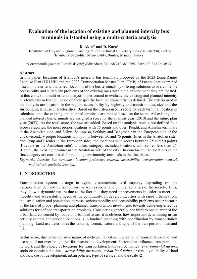
Evaluation of the location of existing and planned intercity bus
terminals in Istanbul using a multi-criteria analysis
D. Akın1* and D. Kara2
1Department of City and Regional Planning, Yildiz Technical University, Besiktas, Istanbul, Turkey2Istanbul Metropolitan Municipality, Bimtas, Istanbul, Turkey
*Corresponding author: E-mail: [email protected], Tel +90 212 383 2592, Fax: +90 212 261 0549
Abstract
In this paper, locations of Istanbul’s intercity bus terminals proposed by the 2023 Long-RangeLanduse Plan (LRLUP) and the 2023 Transportation Master Plan (TMP) of Istanbul are examined
based on the criteria that affect locations of the bus terminals by offering solutions to overcome theaccessibility and suitability problems of the existing ones within the environment they are located.In this context, a multi-criteria analysis is performed to evaluate the existing and planned intercity
bus terminals in Istanbul based on their specific location characteristics defined. The criteria used inthe analysis are location in the region, accessibility by highway and transit modes, size and thesurrounding landuse characteristics. Based on the criteria used, a score for each terminal location iscalculated and the existing and planned terminals are ranked based on the score. All existing and
planned intercity bus terminals are assigned a score for the analysis year (2010) and the future planyear (2023). As the total score, the two are added. Based on the analysis results, we defined four score categories: the most proper locations with 75 points and over (Pendik and Ataşehir terminalsin the Anatolian side, and Silivri, Selimpasa, Sefaköy and Bahçeşehir in the European side of thecity), secondary proper locations with points between 50 and 75 points (Imes in the Anatolian side,and Eyüp and Esenler in the European side), the locations with scores between 25 and 50 points
(Kavacık in the Anatolian side), and last category included locations with scores less than 25(Harem, the existing terminal in the Anatolian side of the city). In conclusion, the locations in thefirst category are considered for planning new intercity terminals in the first place. Keywords: Intercity bus terminals; location preference criteria; accessibility; transportation network,
multicriteria analysis; Istanbul.
1. INTRODUCTION
Transportation systems change in types, characteristics and capacity depending on thetransportation demand by compulsory as well as social and cultural activities of the society. Thus,they show a dynamic nature due to the fact that they need improvements in order to meet the
mobility and accessibility needs of the community. In developing cities with rapid urbanization,industrialization and population increase, serious mobility and accessibility problems occur becauseof the lack of proper planning and planned transportation investments towards achieving effectivesolutions for defined transportation problems. Considering generally one third to one quarter of theurban land consumed by roads in urbanized areas, it is obvious how important determining urbanactivity centers and service locations is in landuse planning with coordination by transportation
planning. Land use determines the volume, format, feature and type of the transportation demand[1].
In this sense, due to the dynamic nature of metropolitan cities, interaction of transportation and landuse should not ever be ignored for sustainable development. Factors that influence transportationnetwork and the choice of locations for transportation hubs can be named environmental factors,socio-economic conditions, accessibility measures, urban land value or rent, availability of landand size, cost of development, urban policies, type of service, and the scale [2].
7/28/2019 D. Akın ve D. Kara_ingilizcesi
http://slidepdf.com/reader/full/d-akin-ve-d-karaingilizcesi 2/11
Istanbul has become a center of attraction with its location and its commercial, economic, financial,cultural, educational and social aspects in the country. Activities carried out in Istanbul constitutemore than one-third of the activities carried out in the country. On the other hand, Istanbul is themain center in Turkey's international transport links with outside the world. In this respect,Istanbul’s intercity, regional and international transportation links must be strong and its
transportation hubs must be accessible that allow facilitated external connections, and they, in turn,enrich economical activities that have a direct relationship with its transportation capacity.
Istanbul’s existing bus terminals (Harem in the Anatolian side and Esenler in the European side) are jammed in the city center by time and the trips made to reach to these points are intensive in themetropolitan area. Thus, this draws a greater attention to a need of the development of intercity busterminal system, i.e., in addition to one large terminal, several smaller ones need to be developed on
both sides of the city. This study made possible to evaluate Istanbul’s existing and planned intercity bus terminals via a multi-criteria analysis.
2. METHODOLOGY
Evaluation of the location of the bus terminals using the multicriteria analysis are made both for theanalysis year (2010) and the future plan year (2023). Main criteria used for the evaluation are:
• location,
• accessibility,
• possibility for expansion, and
• characteristics of the surrounding environment.
Steps of the methodology are as follows [3]:1. Four main criteria and ten subcriteria are determined to evaluate the location of the bus
terminals (Table 1). Table 1. Main criteria in the analysis of bus terminals
Main criteria Subcriteria
I. Location 1. Location in the urban area2. Population density3. Land values
II. Accessibility 4. Proximity to main artery roads5. Proximity to urban rail stations6. Proximity to other transport centers (airport,seaport, regional, national/international railwaystation)
7. Access time by highway and transport modesIII. Size of the area for expansion 8. Availability of land for expansionIV. Characteristics of the surrounding
environment
9. Geological conditions of the surrounding area10. Land use structure of the surrounding area
2. Spatial analysis maps are created using the ten subcriteria for evaluating the locations of theexisting and planned bus terminals for the analysis year (2010) and the year of 2023,separately.
3. In order to determine weights of the criteria, an expert survey was conducted with 107 professionals in the academia as well in government offices (city and regional planners,
transportation planners, transportation and traffic engineers).4. Weights and the values of the criteria (Table 2) are multiplied to obtain the total scores for
the bus terminal areas.
7/28/2019 D. Akın ve D. Kara_ingilizcesi
http://slidepdf.com/reader/full/d-akin-ve-d-karaingilizcesi 3/11
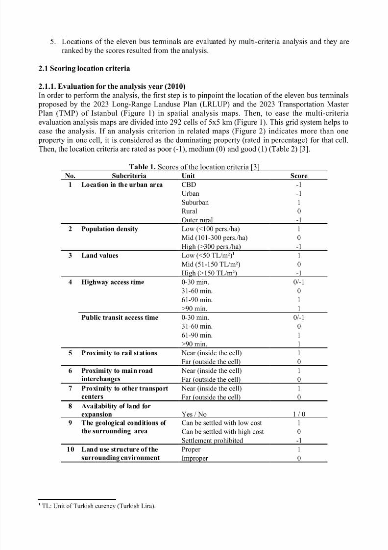
5. Locations of the eleven bus terminals are evaluated by multi-criteria analysis and they areranked by the scores resulted from the analysis.
2.1 Scoring location criteria
2.1.1. Evaluation for the analysis year (2010)
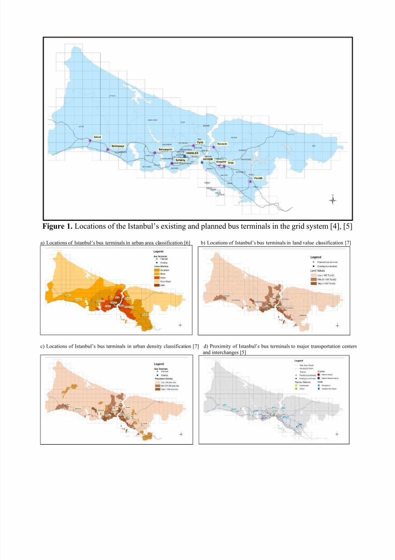
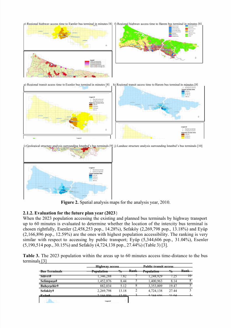
In order to perform the analysis, the first step is to pinpoint the location of the eleven bus terminals proposed by the 2023 Long-Range Landuse Plan (LRLUP) and the 2023 Transportation Master Plan (TMP) of Istanbul (Figure 1) in spatial analysis maps. Then, to ease the multi-criteriaevaluation analysis maps are divided into 292 cells of 5x5 km (Figure 1). This grid system helps toease the analysis. If an analysis criterion in related maps (Figure 2) indicates more than one
property in one cell, it is considered as the dominating property (rated in percentage) for that cell.Then, the location criteria are rated as poor (-1), medium (0) and good (1) (Table 2) [3].
Table 1. Scores of the location criteria [3]No. Subcriteria Unit Score
1 Location in the urban area CBD -1
Urban -1Suburban 1Rural 0Outer rural -1
2 Population density Low (<100 pers./ha) 1Mid (101-300 pers./ha) 0High (>300 pers./ha) -1
3 Land values Low (<50 TL/m²)1 1Mid (51-150 TL/m²) 0High (>150 TL/m²) -1
4 Highway access time 0-30 min. 0/-1
31-60 min. 061-90 min. 1>90 min. 1
Public transit access time 0-30 min. 0/-131-60 min. 061-90 min. 1>90 min. 1
5 Proximity to rail stations Near (inside the cell) 1Far (outside the cell) 0
6 Proximity to main road
interchanges
Near (inside the cell) 1Far (outside the cell) 0
7 Proximity to other transport
centers Near (inside the cell) 1Far (outside the cell) 0
8 Availability of land for
expansion Yes / No 1 / 09 The geological conditions of
the surrounding area
Can be settled with low cost 1Can be settled with high cost 0Settlement prohibited -1
10 Land use structure of the
surrounding environment
Proper 1Improper 0
1 TL: Unit of Turkish curency (Turkish Lira).
7/28/2019 D. Akın ve D. Kara_ingilizcesi
http://slidepdf.com/reader/full/d-akin-ve-d-karaingilizcesi 4/11
Figure 1. Locations of the Istanbul’s existing and planned bus terminals in the grid system [4], [5]
a) Locations of Istanbul’s bus terminals in urban area classification [6] b) Locations of Istanbul’s bus terminals in land value classification [7]
c) Locations of Istanbul’s bus terminals in urban density classification [7] d) Proximity of Istanbul’s bus terminals to major transportation centersand interchanges [5]
7/28/2019 D. Akın ve D. Kara_ingilizcesi
http://slidepdf.com/reader/full/d-akin-ve-d-karaingilizcesi 5/11
e) Regional highway access time to Esenler bus terminal in minutes [8] f) Regional highway access time to Harem bus terminal in minutes [8]
g) Regional transit access time to Esenler bus terminal in minutes [8] h) Regional transit access time to Harem bus terminal in minutes [8]
i) Geological structure analysis surrounding Istanbul’s bus terminals [9] j) Landuse structure analysis surrounding Istanbul’s bus terminals [10]
Figure 2. Spatial analysis maps for the analysis year, 2010.
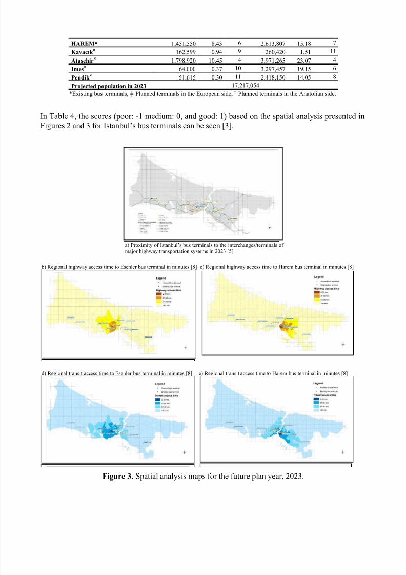
2.1.2. Evaluation for the future plan year (2023)When the 2023 population accessing the existing and planned bus terminals by highway transportup to 60 minutes is evaluated to determine whether the location of the intercity bus terminal is
chosen rightfully, Esenler (2,458,253 pop., 14.28%), Sefaköy (2,269,798 pop., 13.18%) and Eyüp(2,166,896 pop., 12.59%) are the ones with highest population accessibility. The ranking is verysimilar with respect to accessing by public transport; Eyüp (5,344,606 pop., 31.04%), Esenler (5,190,514 pop., 30.15%) and Sefaköy (4,724,138 pop., 27.44%) (Table 3) [3].
Table 3. The 2023 population within the areas up to 60 minutes access time-distance to the busterminals [3]
Bus Terminals
Highway access Public transit access
Population % Rank Population % Rank
Silivriǂ 1,346,288 7.82 7 1,248,929 7.25 10
Selimpaşaǂ 1,452,876 8.44 5 1,400,963 8.14 8
Bahçeşehirǂ
882,034 5.128
3,353,009 19.475
Sefaköyǂ 2,269,798 13.18 2 4,724,138 27.44 3
Eyüpǂ 2,166,896 12.59 3 5,344,606 31.04 1
ESENLER* 2,458,253 14.28 1 5,190,514 30.15 2
7/28/2019 D. Akın ve D. Kara_ingilizcesi
http://slidepdf.com/reader/full/d-akin-ve-d-karaingilizcesi 6/11
HAREM* 1,451,550 8.43 6 2,613,807 15.18 7
Kavacık ˟ 162,599 0.94 9 260,420 1.51 11
Ataşehir˟ 1,798,920 10.45 4 3,971,265 23.07 4
Imes˟ 64,000 0.37 10 3,297,457 19.15 6
Pendik ˟ 51,615 0.30 11 2,418,150 14.05 8
Projected population in 2023 17,217,054
*Existing bus terminals, Planned terminals in the European side, Planned terminals in the Anatolian side.ǂ ˟
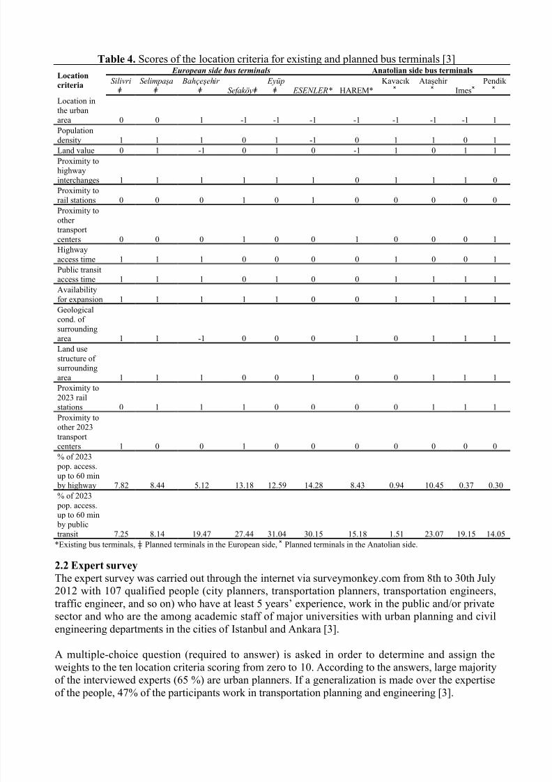
In Table 4, the scores (poor: -1 medium: 0, and good: 1) based on the spatial analysis presented inFigures 2 and 3 for Istanbul’s bus terminals can be seen [3].
a) Proximity of Istanbul’s bus terminals to the interchanges/terminals of major highway transportation systems in 2023 [5]
b) Regional highway access time to Esenler bus terminal in minutes [8] c) Regional highway access time to Harem bus terminal in minutes [8]
d) Regional transit access time to Esenler bus terminal in minutes [8] e) Regional transit access time to Harem bus terminal in minutes [8]
Figure 3. Spatial analysis maps for the future plan year, 2023.
7/28/2019 D. Akın ve D. Kara_ingilizcesi
http://slidepdf.com/reader/full/d-akin-ve-d-karaingilizcesi 7/11
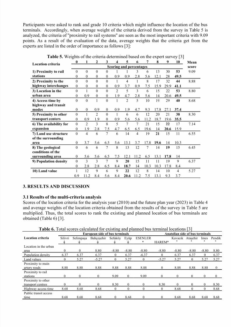
Table 4. Scores of the location criteria for existing and planned bus terminals [3]
Location
criteria
European side bus terminals Anatolian side bus terminals
Silivri ǂ
Selimpaşa ǂ
Bahçeşehir ǂ Sefaköy ǂ
Eyüp ǂ ESENLER* HAREM*
Kavacık ˟
Ataşehir ˟ Imes˟
Pendik ˟
Location inthe urbanarea 0 0 1 -1 -1 -1 -1 -1 -1 -1 1Populationdensity 1 1 1 0 1 -1 0 1 1 0 1Land value 0 1 -1 0 1 0 -1 1 0 1 1Proximity tohighwayinterchanges 1 1 1 1 1 1 0 1 1 1 0Proximity torail stations 0 0 0 1 0 1 0 0 0 0 0Proximity toother transportcenters 0 0 0 1 0 0 1 0 0 0 1Highwayaccess time 1 1 1 0 0 0 0 1 0 0 1
Public transitaccess time 1 1 1 0 1 0 0 1 1 1 1Availabilityfor expansion 1 1 1 1 1 0 0 1 1 1 1Geologicalcond. of surroundingarea 1 1 -1 0 0 0 1 0 1 1 1Land usestructure of surroundingarea 1 1 1 0 0 1 0 0 1 1 1Proximity to2023 rail
stations 0 1 1 1 0 0 0 0 1 1 1Proximity toother 2023transportcenters 1 0 0 1 0 0 0 0 0 0 0% of 2023 pop. access.up to 60 min by highway 7.82 8.44 5.12 13.18 12.59 14.28 8.43 0.94 10.45 0.37 0.30% of 2023 pop. access.up to 60 min by publictransit 7.25 8.14 19.47 27.44 31.04 30.15 15.18 1.51 23.07 19.15 14.05
*Existing bus terminals, Planned terminals in the European side, Planned terminals in the Anatolian side.ǂ ˟
2.2 Expert survey
The expert survey was carried out through the internet via surveymonkey.com from 8th to 30th July2012 with 107 qualified people (city planners, transportation planners, transportation engineers,traffic engineer, and so on) who have at least 5 years’ experience, work in the public and/or privatesector and who are the among academic staff of major universities with urban planning and civilengineering departments in the cities of Istanbul and Ankara [3].
A multiple-choice question (required to answer) is asked in order to determine and assign theweights to the ten location criteria scoring from zero to 10. According to the answers, large majority
of the interviewed experts (65 %) are urban planners. If a generalization is made over the expertiseof the people, 47% of the participants work in transportation planning and engineering [3].
7/28/2019 D. Akın ve D. Kara_ingilizcesi
http://slidepdf.com/reader/full/d-akin-ve-d-karaingilizcesi 8/11
Participants were asked to rank and grade 10 criteria which might influence the location of the busterminals. Accordingly, when average weight of the criteria derived from the survey in Table 5 isanalyzed, the criteria of ''proximity to rail systems'' are seen as the most important criteria with 9.09
points. As a result of the evaluation of the data, average weights that the criteria get from theexperts are listed in the order of importance as follows [3]:
Table 5. Weights of the criteria determined based on the expert survey [3]Location criteria
0 1 2 3 4 5 6 7 8 9 10 Mean
scoreScoring and percentages
1) Proximity to rail
stations
0 0 0 0 1 1 3 6 13 30 53 9.090 0 0 0 0.9 0.9 2.8 5.6 12.1 28 49.5
2) Proximity to the
highway interchanges
0 0 0 0 1 4 1 8 17 32 44 8.880 0 0 0 0.9 3.7 0.9 7.5 15.9 29.9 41.1
3) Location in the
urban area
0 1 0 0 2 5 3 6 15 22 53 8.800 0.9 0 0 1.9 4.7 2.8 5.6 14 20.6 49.5
4) Access time by
highway and transit
modes
0 0 1 0 1 2 5 10 19 29 40 8.68
0 0 0.9 0 0.9 1.9 4.7 9.3 17.8 27.1 37.4
5) Proximity to othertransport centers
0 1 2 0 1 6 6 12 20 21 38 8.300 0.9 1.9 0 0.9 5.6 5.6 11.2 18.7 19.6 35.5
6) The availability for
expansion
0 2 3 8 5 7 7 21 15 22 17 7.140 1.9 2.8 7.5 4.7 6.5 6.5 19.6 14 20.6 15.9
7) Land use structure
of the surrounding
area
0 4 6 7 6 14 4 19 21 15 11 6.55
0 3.7 5.6 6.5 5.6 13.1 3.7 17.8 19.6 14 10.38) The geological
conditions of the
surrounding area
0 6 6 7 8 13 12 7 14 19 15 6.45
0 5.6 5.6 6.5 7.5 12.1 11.2 6.5 13.1 17.8 149) Population density 0 3 3 7 9 20 15 11 11 19 9 6.37
0 2.8 2.8 6.5 8.4 18.7 14 10.3 10.3 17.8 8.4
10) Land value 1 12 9 6 9 22 12 8 14 10 4 5.270.9 11.2 8.4 5.6 8.4 20.6 11.2 7.5 13.1 9.3 3.7
3. RESULTS AND DISCUSSION
3.1 Results of the multi-criteria analysis
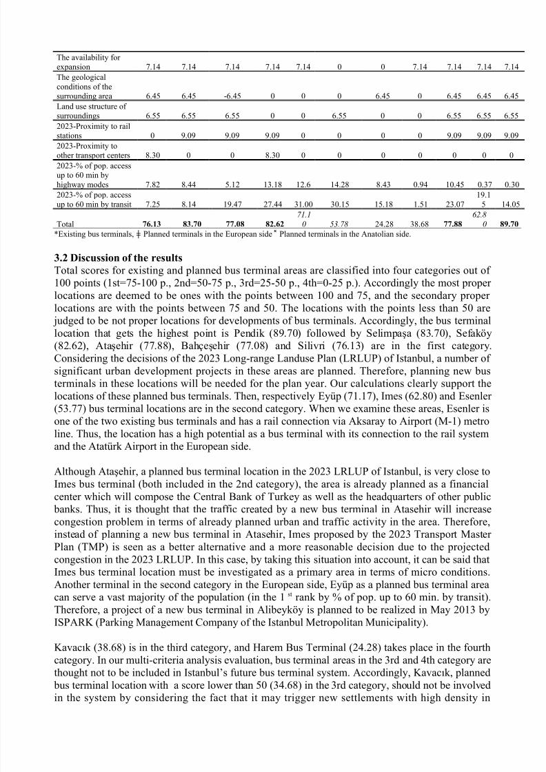
Scores of the location criteria for the analysis year (2010) and the future plan year (2023) in Table 4and average weights of the location criteria obtained from the results of the survey in Table 5 aremultiplied. Thus, the total scores to rank the existing and planned location of bus terminals areobtained (Table 6) [3].
Table 6. Total scores calculated for existing and planned bus terminal locations [3]Location criteria
European side of bus terminals Anatolian side of bus terminals
Silivriǂ
Selimpaşaǂ
Bahçeşehir ǂ
Sefaköyǂ
Eyüpǂ
ESENLER * HAREM*
Kavacık ˟
Ataşehir ˟
Imes˟
Pendik ˟
Location in the urbanarea 0 0 8.80 -8.80 -8.80 -8.80 -8.80 -8.80 -8.80 -8.80 8.80Population density 6.37 6.37 6.37 0 6.37 -6.37 0 6.37 6.37 0 6.37Land values 0 5.27 -5.27 0 5.27 0 -5.27 5.27 0 5.27 5.27Proximity to mainartery roads 8.88 8.88 8.88 8.88 8.88 8.88 0 8.88 8.88 8.88 0Proximity to railstations 0 0 0 9.09 0 9.09 0 0 0 0 0Proximity to other transport centres 0 0 0 8.30 0 0 8.30 0 0 0 8.30Highway access time 8.68 8.68 8.68 0 0 0 0 8.68 0 0 8.68Public transit accesstime 8.68 8.68 8.68 0 8.68 0 0 8.68 8.68 8.68 8.68
7/28/2019 D. Akın ve D. Kara_ingilizcesi
http://slidepdf.com/reader/full/d-akin-ve-d-karaingilizcesi 9/11
The availability for expansion 7.14 7.14 7.14 7.14 7.14 0 0 7.14 7.14 7.14 7.14The geologicalconditions of thesurrounding area 6.45 6.45 -6.45 0 0 0 6.45 0 6.45 6.45 6.45Land use structure of surroundings 6.55 6.55 6.55 0 0 6.55 0 0 6.55 6.55 6.552023-Proximity to rail
stations 0 9.09 9.09 9.09 0 0 0 0 9.09 9.09 9.092023-Proximity toother transport centers 8.30 0 0 8.30 0 0 0 0 0 0 02023-% of pop. accessup to 60 min byhighway modes 7.82 8.44 5.12 13.18 12.6 14.28 8.43 0.94 10.45 0.37 0.302023-% of pop. accessup to 60 min by transit 7.25 8.14 19.47 27.44 31.00 30.15 15.18 1.51 23.07
19.15 14.05
Total 76.13 83.70 77.08 82.62
71.10 53.78 24.28 38.68 77.88
62.80 89.70
*Existing bus terminals, Planned terminals in the European side Planned terminals in the Anatolian side.ǂ ˟
3.2 Discussion of the results
Total scores for existing and planned bus terminal areas are classified into four categories out of 100 points (1st=75-100 p., 2nd=50-75 p., 3rd=25-50 p., 4th=0-25 p.). Accordingly the most proper locations are deemed to be ones with the points between 100 and 75, and the secondary proper locations are with the points between 75 and 50. The locations with the points less than 50 are
judged to be not proper locations for developments of bus terminals. Accordingly, the bus terminallocation that gets the highest point is Pendik (89.70) followed by Selimpaşa (83.70), Sefaköy(82.62), Ataşehir (77.88), Bahçeşehir (77.08) and Silivri (76.13) are in the first category.Considering the decisions of the 2023 Long-range Landuse Plan (LRLUP) of Istanbul, a number of significant urban development projects in these areas are planned. Therefore, planning new busterminals in these locations will be needed for the plan year. Our calculations clearly support thelocations of these planned bus terminals. Then, respectively Eyüp (71.17), Imes (62.80) and Esenler
(53.77) bus terminal locations are in the second category. When we examine these areas, Esenler isone of the two existing bus terminals and has a rail connection via Aksaray to Airport (M-1) metroline. Thus, the location has a high potential as a bus terminal with its connection to the rail systemand the Atatürk Airport in the European side.
Although Ataşehir, a planned bus terminal location in the 2023 LRLUP of Istanbul, is very close toImes bus terminal (both included in the 2nd category), the area is already planned as a financialcenter which will compose the Central Bank of Turkey as well as the headquarters of other public
banks. Thus, it is thought that the traffic created by a new bus terminal in Atasehir will increasecongestion problem in terms of already planned urban and traffic activity in the area. Therefore,instead of planning a new bus terminal in Atasehir, Imes proposed by the 2023 Transport Master Plan (TMP) is seen as a better alternative and a more reasonable decision due to the projectedcongestion in the 2023 LRLUP. In this case, by taking this situation into account, it can be said thatImes bus terminal location must be investigated as a primary area in terms of micro conditions.Another terminal in the second category in the European side, Eyüp as a planned bus terminal areacan serve a vast majority of the population (in the 1 st rank by % of pop. up to 60 min. by transit).Therefore, a project of a new bus terminal in Alibeyköy is planned to be realized in May 2013 byISPARK (Parking Management Company of the Istanbul Metropolitan Municipality).
Kavacık (38.68) is in the third category, and Harem Bus Terminal (24.28) takes place in the fourthcategory. In our multi-criteria analysis evaluation, bus terminal areas in the 3rd and 4th category are
thought not to be included in Istanbul’s future bus terminal system. Accordingly, Kavacık, planned bus terminal location with a score lower than 50 (34.68) in the 3rd category, should not be involvedin the system by considering the fact that it may trigger new settlements with high density in
7/28/2019 D. Akın ve D. Kara_ingilizcesi
http://slidepdf.com/reader/full/d-akin-ve-d-karaingilizcesi 10/11
Beykoz district located in the northern part of the city in the Anatolian side. In the last category,Harem Bus Terminal (24.29) is found appropriate to remove from the system for the reasons that itsservice area is quite small and it is located in an area with no possibility of improvements. HaremBus Terminal is insufficient for the metropolis, besides it causes significant congestion problems inthe place where it is located. Harem Bus Terminal is now located in the center of the city and lostits significance because of the differentiation in the direction of urban development and the
introduction of ring road for the intercity transportation of Istanbul. In urban scale, especially in theAnatolian side of the city, a new central bus terminal area is needed and that can be Ataşehir or Imes based on our analysis.
4. CONCLUSIONS
In this paper, we evaluated the locations of Istanbul’s intercity bus terminals proposed by the 2023Long-Term Landuse Plan (LRLUP) and the 2023 Transportation Master Plan (TMP) of Istanbul
based on the criteria that affect locations of the bus terminals by offering solutions to overcome theaccessibility and suitability problems of the existing ones within the environment they are located.Out of nine planned intercity bus terminals, our analysis found six of them highly feasible, two of
them moderately feasible, and one of them infeasible. Esenler, one of the existing terminal in theEuropean side, got a score over 50, but the one in the Anatolian side, Harem, resulted a poor score(24.28). This indicates that it needs to be removed from its current place to either Ataşehir (proposed by the 2023 LRLUP) or Imes (proposed by the 2023 TMP) based on the score of the new
proposed locations. Main conclusions that can be drawn from our study are as follows;
• It is proved that the criteria used to evaluate locations of urban developments such asintercity transportation hubs can be assessed by analytical methods,
• Proximity to urban rail stations and highway interchanges are the most influential factorsfor planning intercity bus terminals,
•
Location in the area and access time by all modes are again among the most influentialfactors,• Multi-criteria analysis is expected to yield more feasible results than the analysis with
only a few criteria.• Planning should always be based on multi-criteria analysis, otherwise some investments
can be made for infeasible projects or some urgent investments can be left behind their planned schedule.
Cities, like Istanbul should have a planned structure of the urban macroform, enabling ease of access and departure of intercity passengers within a planned bus terminal system. Operations of intercity buses from a single center cause waste of time and money. Therefore, building of a system
of transfer facilities from intercity transportation to urban transportation modes is essential for increasing the quality of service of intercity bus transportation. Considering the fact that some of thelargest companies use Dudullu, Kartal and Ataşehir transfer points already in Anatolian side reveala significant trend that creates advantages for users in terms of reducing time of access and cost of transfer. However, this trend should be handled in a planned manner. In this way, intercity bustransportation will be more convenient and faster by organizing the bus terminal areas in a plannedway for the welfare of public.
Bus terminals that are close to ring roads have high accessibility and integration with other transporthubs improve the level of service of intercity bus transportation. For this reason, it is important for
bus terminals to have high standard highway and railway connections in order to provide transfer convenience and most importantly to strengthen the public transport system.
7/28/2019 D. Akın ve D. Kara_ingilizcesi
http://slidepdf.com/reader/full/d-akin-ve-d-karaingilizcesi 11/11
When Istanbul’s bus terminal locations are evaluated in the existing conditions, Esenler BusTerminal has a number of positive aspects in terms of the location criteria. Essentially, thoseintercity trip production-attraction areas must be planned within the structure of urban developmentaxes in the European side and that system extends to Ataturk International Airport. On the other hand, the Sirkeci-Halkalı Railway transferring point can be seen as a feasible location for theintercity bus terminal.
Acknowledgement
This paper is a part of the Master’s Thesis titled “Yerseçim İlkeleri Doğrultusunda IstanbulOtogarlarının ve Öneri Otogar Alanlarının Çok Ölçütlü Değerlendirmesi” submitted to the GraduateSchool of Bahçeşehir University in October 2012 by the first author of this paper under thesupervision of the second author.
References
1. Blunden, W.R., 1971. The Land-use / transport system, Pergamon Press Ltd., Headington
Hill Hall, Oxford: Great Britain.2. Hamamcıoglu, C., 2009. Ulaşım ağının kentsel hizmet alanlarının yer seçimine etkilerinin
Istanbul Tarihi Yarımada örneğinde değerlendirilmesi, Doktora Tezi, İstanbul Yıldız Teknik Üniversitesi FBE. İstanbul.
3. Kara, D., 2012. Yer seçim ilkeleri doğrultusunda İstanbul otogarlarının ve öneri otogar alanlarının çok ölçütlü değerlendirmesi. Yüksek Lisans Tezi, Bahçeşehir Üniversitesi FBE.İstanbul.
4. İBB, İmar ve Şehircilik Daire Başkanlığı, Şehir Planlama Müdürlüğü, 2009. 1/100.000Ölçekli İstanbul Çevre Düzeni Planı raporu İstanbul.
5. İBB Ulaşım Daire Başkanlığı. Ulaşım Planlama Müdürlüğü, 2011. İstanbul Metropoliten Alanı Kentsel Ulaşım Ana Planı (İUAP) raporu, İstanbul.
6. İBB, Ulaşım Daire Başkanlığı, Ulaşım Planlama Müdürlüğü, 2007. İstanbul Ulaşım Master Planı Revize Edilmesi Projesi Kapsamında ATTÜK raporu İstanbul.
7. İBB, İmar ve Şehircilik Daire Başkanlığı, Şehir Planlama Müdürlüğü, 2006. İMP konut ve yaşam kalitesi grubu raporu, İstanbul.
8. İBB, Ulaşım Daire Başkanlığı, Ulaşım Planlama Müdürlüğü, 2011. İstanbul Metropoliten Alanı Kentsel Ulaşım Ana Planı (IUAP) yolculuk talep modeli verileri İstanbul.
9. İBB, Şehir Planlama Müdürlüğü, İstanbul büyükşehir alanı ve çevresinde; tarım sektörünün gelişim sürecinin mekânsal boyutu ile birlikte incelenmesi ve araştırılması, bu sektörün geleceğe dönük gelişme eğilim ve potansiyellerinin belirlenmesi, planlamaya dönük gelişme stratejileri ve modellerinin tanımlanması konularına yönelik analitik etüd işi, özel teknik
şartname no: 6.5.3. yerbilimleri sentez ve önerileri, İstanbul.10. İBB, İmar ve Şehircilik Daire Başkanlığı, Şehir Planlama Müdürlüğü, 2006. İMP arazi
kullanım raporu, İstanbul. (2009-2010 yılı güncelleme)