cycle infrastructure database asset information guide
TRANSCRIPT

Cycle Infrastructure Database
Asset Information Guide

2
Contents Introduction ........................................................................................... 6
1.1. Features ..................................................................................................................... 6
1.2. Linear Data collection ................................................................................................. 6
1.3. Point Data collection ................................................................................................ 10
Linear Infrastructure ........................................................................... 12
2.1. Cycle Lanes and Tracks ........................................................................................... 12
2.1.1. On or off carriageway ............................................................................................... 12
2.1.2. Mandatory or advisory cycle lanes ........................................................................... 15
2.1.3 Segregated lanes or tracks ...................................................................................... 18
2.1.4. Stepped lane/track ................................................................................................... 20
2.1.5. Partially or light segregated lane or track ................................................................ 22
2.1.6. Shared lane or footway ............................................................................................ 26
2.1.7. Priority ...................................................................................................................... 31
2.1.8. Contraflow lane/track ............................................................................................... 32
2.1.9. Bi-directional ............................................................................................................. 34
2.1.10. Cycle bypass ............................................................................................................ 35
1.1.11. Continuous cycle facility through a bus stop ............................................................ 36
2.1.12. Park route ................................................................................................................. 37
2.1.13. Waterside route ........................................................................................................ 38
2.1.14. Is the cycle lane/track part-time? ............................................................................. 40
2.1.15. Access times ............................................................................................................ 41
2.1.16. Colour ....................................................................................................................... 42
2.2. Advance stop line (ASL) ........................................................................................... 43
2.2.1. Feeder lane left ........................................................................................................ 44
2.2.2. Centre feeder lane.................................................................................................... 45
2.2.3. Feeder lane right ...................................................................................................... 46
2.2.4. Shared nearside lane (SNSL) .................................................................................. 46
2.3. Crossing ................................................................................................................... 47
2.3.1. Signal controlled crossing ........................................................................................ 47
2.3.2. Segregated cycles and pedestrians ......................................................................... 48
2.3.3. Cycle gap.................................................................................................................. 51
2.3.4. Pedestrian only crossing .......................................................................................... 52
2.3.5. Level crossing .......................................................................................................... 52
2.4.1. Pedestrian only route ............................................................................................... 53

3
2.4.2. Pedestrian bridge ..................................................................................................... 54
2.4.3. Pedestrian tunnel ..................................................................................................... 55
2.4.4. Steps ........................................................................................................................ 56
2.4.5. Lift ............................................................................................................................. 56
Point infrastructure ............................................................................. 57
3.1. Signs and markings .................................................................................................. 57
3.1.1. Road/footway markings or signs .............................................................................. 57
3.1.2. Coloured patch ......................................................................................................... 58
3.1.3. Facing off-side .......................................................................................................... 59
3.1.4. Sign/symbol diagram number .................................................................................. 60
3.1.5. Signing attributes ...................................................................................................... 63
3.1.6. Prohibition................................................................................................................. 63
3.1.7. No vehicles ............................................................................................................... 64
3.1.8. Circular or rectangular .............................................................................................. 65
3.1.9. Exemption sign ......................................................................................................... 66
3.1.10. Turning exceptions ................................................................................................... 67
3.1.11. Banned left turn ........................................................................................................ 67
3.1.12. Banned right turn ...................................................................................................... 67
3.1.13. Compulsory left turn ................................................................................................. 68
3.1.14. Compulsory right turn ............................................................................................... 68
3.1.15. Banned ahead .......................................................................................................... 69
3.1.16. Cyclists dismount ..................................................................................................... 70
3.1.17. End of Route ............................................................................................................ 70
3.1.18. Cycle symbol ............................................................................................................ 71
3.1.19. Pedestrian symbol .................................................................................................... 72
3.1.20. Bus symbol ............................................................................................................... 72
3.1.21. Other vehicle symbol ................................................................................................ 72
3.1.22. Delineator Line on sign ............................................................................................ 73
3.1.23. Direction arrow ......................................................................................................... 73
3.1.24. Destination ............................................................................................................... 73
3.1.25. Number in box .......................................................................................................... 75
3.1.26. National Cycle Network ............................................................................................ 76
3.1.27. London Cycle Network ............................................................................................. 77
3.1.28. Cycle Superhighway ................................................................................................ 77
3.1.29. Quietway................................................................................................................... 79
3.1.30. Greenway ................................................................................................................. 80

4
3.1.31. Route number ........................................................................................................... 80
3.1.32. Access times ............................................................................................................ 81
3.2. Signals ...................................................................................................................... 81
3.2.1. Cycle on signal head ................................................................................................ 81
3.2.2. Separate stage for cycles ......................................................................................... 83
3.2.3. Early release ............................................................................................................ 83
3.2.4. Two stage turn .......................................................................................................... 84
3.2.5. Cycle Gate/Bus Gate ............................................................................................... 84
3.3. Traffic calming .......................................................................................................... 85
3.3.1. Raised table ............................................................................................................. 85
3.3.2. Raised side road entry treatment ............................................................................. 86
3.3.3. Speed cushion .......................................................................................................... 87
3.3.4. Speed hump ............................................................................................................. 87
3.3.5. Sinusoidal ................................................................................................................. 88
3.3.6. Narrowings (including pinch points and chicanes)................................................... 89
3.3.7. Barrier ....................................................................................................................... 90
3.3.8. Other traffic calming ................................................................................................. 91
3.4. Miscellaneous point features.................................................................................... 91
3.4.1. Steps ........................................................................................................................ 91
3.4.2. Lift ............................................................................................................................. 91
3.5. Cycle Parking ........................................................................................................... 91
3.5.1. On-carriageway ........................................................................................................ 92
3.5.2. Covered .................................................................................................................... 93
3.5.3. Secure ...................................................................................................................... 94
3.5.4. Locker ....................................................................................................................... 95
3.5.5. Sheffield stand .......................................................................................................... 96
3.5.6. M stand ..................................................................................................................... 97
3.5.7. P stand ..................................................................................................................... 98
3.5.8. Cyclehoop stand ....................................................................................................... 98
3.5.9. Post stand................................................................................................................. 99
3.5.10. Butterfly stand .......................................................................................................... 99
3.5.11. Wheel rack ............................................................................................................... 99
3.5.12. Bike hangar ............................................................................................................ 100
3.5.13. Two Tier .................................................................................................................. 100
3.5.14. Other or unknown ................................................................................................... 101
3.5.15. Provision number ................................................................................................... 101

5
3.5.16. Capacity number .................................................................................................... 102

6
Introduction The document demonstrates the various types of cycle infrastructure that was collected as part of
the Cycle Infrastructure Database.
Note this document is not a comprehensive list of cycle infrastructure and some terms differ from
those in technical documents such as the LCDS. The photographs provided show typical layouts.
1.1. Features Data was collected as either line features or point features..
Line features include: Point features include:
• Cycle lanes and tracks
• Advance Stop Lines (ASLs)
• Crossings
• Restricted routes
• Signs and symbols
• Signals
• Traffic calming
• Cycle parking
• Restricted routes (point locations)
1.2. Linear Data collection Cycle infrastructure that was collected as line features is drawn aligned to the kerb line if they are
on carriageway or in a position closely representing their real-world positioning if on the footway.
On carriageway line data collection
On carriageway line data were collected aligned to the kerb, drawn to match the start and end of
the associated road markings. They break where the road markings break, e.g. capturing shared
bus lanes the line should not continue through pedestrian crossings or over side roads unless the
bus lane does. They start at the beginning of the taper and finish at the end of the solid white line.
Diagram 1 New Kent Road junction with Rodney Place showing shared part time bus lane on
New Kent Road (indicated by sign)

7
Diagram 1 New Kent Road junction with Rodney Place showing advisory cycle lanes on
Rodney Place
Diagram 3 below shows how the geometry is drawn to match the real-world locations. The
geometry for the shared bus lane on New Kent Road is broken at the junction with Rodney Place
and the pedestrian crossing. In addition, the geometry for the cycle lanes in Rodney Place is not
continued across the side road entry treatment into Rodney Place.
Diagram 3 On-carriageway data collection.

8
Off carriageway line data collection
Off carriageway line data were collected in the centre of the footway or path.
Diagram 4 New Kent Road west of Rodney Place showing shared footway with a bi-
directional cycle track on New Kent Road indicated by sign
Diagram 5 Off-carriageway data collection

9
There are instances where on-carriageway line features (that are not crossings) are drawn away
from the kerb line, e.g. cycle lanes continuing through junctions. However, elephant prints
markings across the carriageway as shown in the photo below are a crossing and are drawn as
such. The short section of track in the photo was recorded as a fully segregated track.
Diagram 6 Elephant footprints at Bricklayers Arms Roundabout
Diagram 7 On-carriageway feature not aligned to kerb line

10
1.3. Point Data collection One-point feature was created for each sign or symbol. If there are multiple signs on a single post
relevant to cycling, then then they were collected as separate points placed on top of each other.
In this instance the sign data were recorded in order from top to bottom and left to right.
On carriageway point data collection
On carriageway point data were collected within the carriageway bounds, at the location of the
feature. Diagram 9 shows an example output.
Diagram 8 Tabard Street junction with Silvester Street
Diagram 9 Point placement for on carriageway cycle symbols
Off carriageway point data collection
Off carriageway point data were collected within the footway or path bounding lines, as close to
the actual location of the feature as possible.

11
One point is placed per feature. Where point features are in the same location (e.g. several signs
on the same post), multiple point features were created one on top on the other. For example, in
Diagram 10 below the ‘No motorised vehicles’ sign and the rectangular cycle sign would be
collected as two points, one on top of the other, with attributes set differently for each sign.
All cycle signs are recorded. Where the signs relate to the movement of vehicles on the road the
signs on the offside were recorded as ‘True’ for offside.
Diagram 11 shows an example output.
Diagram 10 Tabard Street junction with Silvester Street
Diagram 11 Point placement for off carriageway cycle signs/symbols
12
Linear Infrastructure This information was collected as lines drawn to represent their real world location either at the
kerb side or on the footway.
2.1. Cycle Lanes and Tracks These are formally designated facilities for cyclists, usually identified with a combination of signs
and line markings, and very often marked with the cycle symbol.
Cycle lanes are parts of the road marked for use by cyclists. For the purposes of this project, a
bus lane that cyclists may use is regarded as a type of cycle lane.
Cycle tracks are always off-carriageway, either next to it (associated with the footway) or
completely away from the highway (e.g. canal towpaths, routes through parks). The ways that
they are signed are more variable than cycle lanes.
2.1.1. On or off carriageway Is the cycle lane/track on the carriageway? If so, set the attribute to ‘True’.
This includes instances where the cycle lane/track is physically separated from the lane or
lanes used by other traffic but is either at the same level or at a level between the main
carriageway and the footway.
See categories ‘segregated lane or track’ and ‘stepped track’ below.
Is the lane/track either on the footway (i.e. next to the road) or completely away from the
highway (e.g. through a park or by a canal)? Then set the attribute to ‘False’.
On carriageway
Set the attribute to ‘True’ if any of the following features are present, indicating the
existence of a cycle lane:
• solid or dashed white lines, with intermittent cycle symbols (noting that these markings
may be quite faded in some cases) – these are usually, but not always, on the nearside of
the carriageway and could form a contraflow cycle lane, where cyclists are allowed to use
the street in the opposite direction from other traffic
• a coloured strip at the kerbside, with intermittent cycle symbols on the surface
• a bus lane that cyclists may use – this can be checked from the sign showing which
vehicles can use the bus lane (note that while cyclists are allowed in almost all bus lanes
in London this is not automatically the case)
• cycle provision physically separated from the lane or lanes used by other traffic,either at
the same level or at a level between the main carriageway and the footway.

13
Solid and dashed line markings used for cycle lanes
Signs for with-flow cycle lane (left) and contraflow cycle lane (right)
Example of a cycle lane with line marking, cycle symbol, route number and sign.
14
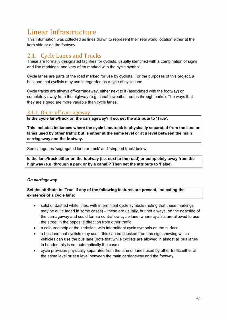
Off carriageway
Set the attribute to ‘False’ if any of the following features are present – indicating the
existence of an off carriageway cycle facility:
• a route adjacent to a road but clearly on a footway (pavement) whether shared with
pedestrians or not
• a route completely away from a road
Cycle facilities off-carriageway come in many forms but are usually identifiable by their signs,
which feature a cycle symbol in some form.
When on the footway, these are usually mounted on a pole but may also appear on bollards or
painted or embedded into the footway surface. Away from the highways, they might appear in a
wider variety of forms.
The ‘standard’ signs are as follows, showing (left to right) a dedicated cycle facility, a facility
divided by a line or raised strip between cyclists and pedestrians, and a facility shared between
cyclists and pedestrians.
These might appear in different colours and formats, particularly away from the highway – see,
for example the Canal and River Trust signing below.

15
2.1.2. Mandatory or advisory cycle lanes (On-carriageway only)
If there is a line marking for a cycle lane on-carriageway, is it solid and is it accompanied
by the ‘mandatory cycle lane’ sign on a post on the footway?
If either or both of the above are ‘True’, set the Mandatory cycle lane attribute to ‘True’.
If the line marking for a cycle lane on-carriageway is dashed or there is a coloured strip for
use by cycles, then set the Advisory cycle lane attribute to ‘True’.
Note that cycle lanes/tracks on-carriageway must be Mandatory, Advisory or neither. Both
attributes must not be set as ‘True’. If the type of lane changes then a new feature must be
drawn.
Mandatory cycle lanes should have the sign below, but this may not be present in all cases. They
will, however, always have the solid lane marking and intermittent cycle symbols within the lane.
Usually the lane begins with the dashed diagonal marking from the kerbside shown below.
Cycle lanes may or may not be coloured. This has no bearing on whether they are mandatory or
advisory.

16
Examples of mandatory cycle lanes
A mandatory cycle lane may appear to the left of (i.e. “within”) a bus lane, in which case only the
‘mandatory or advisory’ attribute should be set to ‘True’ (see ‘shared lane’ below for more detail
and examples).
A mandatory cycle lane may be accompanied by light segregation, i.e. objects to protect the lane,
in which case both the attributes ‘mandatory or advisory’ and ‘partially or light segregated lane or
track’ should be set to ‘True’ (see ‘partially or light segregated lane or track’ below for more detail
and examples).
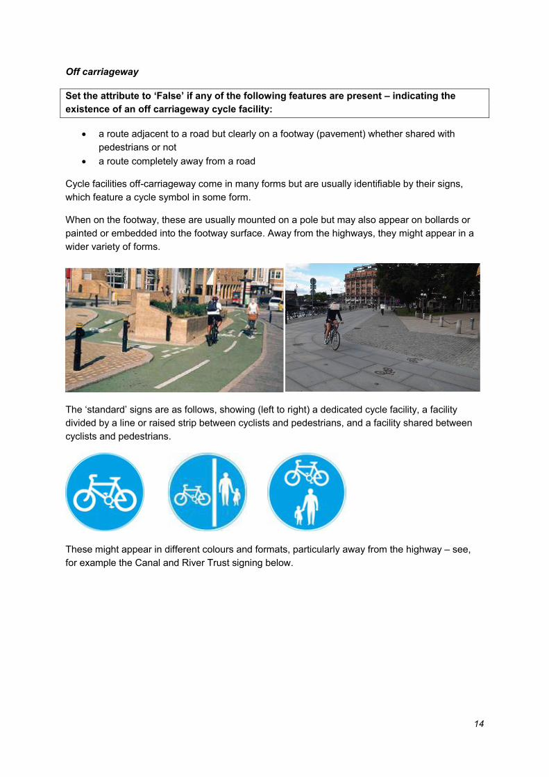
Lanes that are not mandatory cycle lanes are either advisory cycle lanes or unbounded coloured
strips.
An advisory cycle lane is identified by a dashed lane marking and by the intermittent use of cycle
symbols in the lane. Typically, an advisory cycle lane does not have an accompanying sign,
although occasionally the mandatory cycle lane sign or the blue rectangular cycle route sign may
be used.
An ‘unbounded’ coloured strip by the kerbside (i.e. surface colour without any lane markings) is
also a cycle facility and should be recorded as an advisory cycle lane. Note that occasionally the
blue rectangular cycle route sign may be used.
Note that where lanes are marked outside of parking or loading bays, there are occasionally two
sets of lane markings, marking the left- and right-hand extents of the lane. This is a single lane
and should be recorded as such.

17
Examples of advisory cycle lanes (top) and unbounded coloured (strip below)
Mandatory and advisory cycle lanes may also appear with a hatched ‘buffer’ between them and
the adjacent general traffic lanes. This does not affect their status and does not need to be
recorded. It is the innermost line marking that is significant in this case, ie the one that delineates
the cycle facility.
Mandatory cycle lane
18
Advisory cycle lane
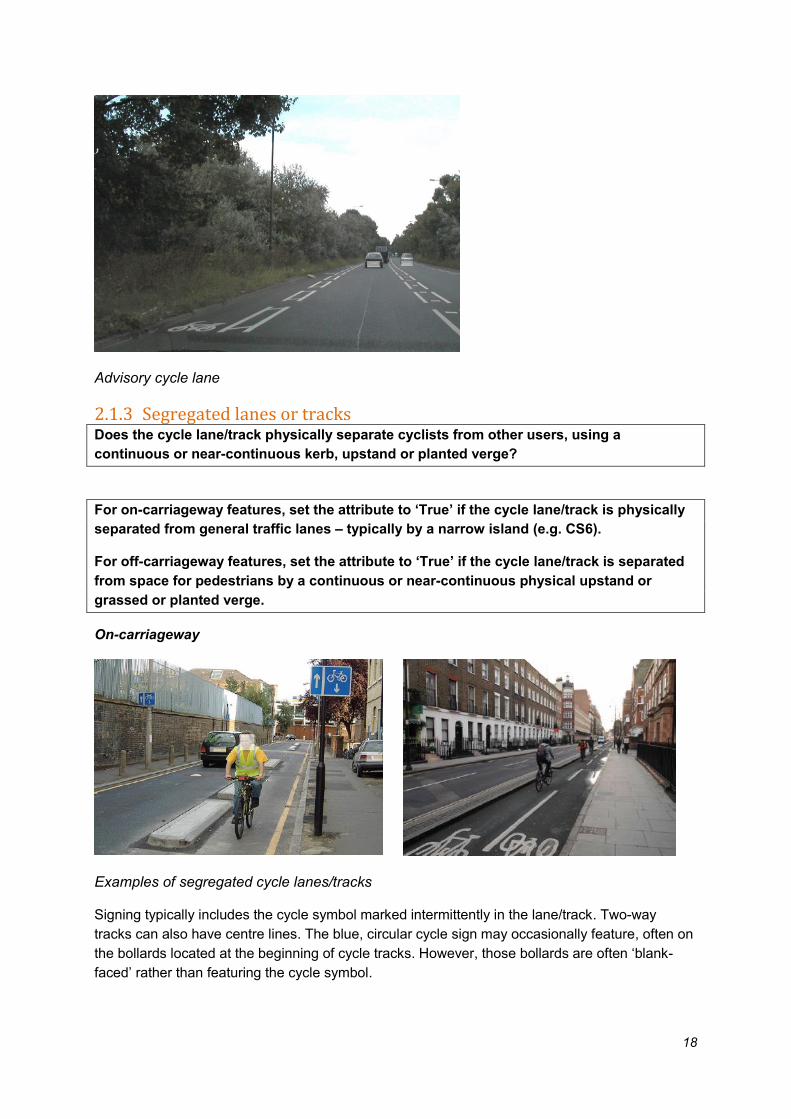
2.1.3 Segregated lanes or tracks Does the cycle lane/track physically separate cyclists from other users, using a
continuous or near-continuous kerb, upstand or planted verge?
For on-carriageway features, set the attribute to ‘True’ if the cycle lane/track is physically
separated from general traffic lanes – typically by a narrow island (e.g. CS6).
For off-carriageway features, set the attribute to ‘True’ if the cycle lane/track is separated
from space for pedestrians by a continuous or near-continuous physical upstand or
grassed or planted verge.
On-carriageway
Examples of segregated cycle lanes/tracks
Signing typically includes the cycle symbol marked intermittently in the lane/track. Two-way
tracks can also have centre lines. The blue, circular cycle sign may occasionally feature, often on
the bollards located at the beginning of cycle tracks. However, those bollards are often ‘blank-
faced’ rather than featuring the cycle symbol.

19
Off-carriageway
In places without motor vehicle access, cyclists are sometimes separated from pedestrians either
by being accommodated in a dedicated cycle track, or by clear physical separation between cycle
and pedestrian paths, e.g. using a planted verge.
Both types can be identified using surface markings and, occasionally, surface colour, to show
the areas for cyclists. Pedestrian areas are sometimes, but not always, marked with a pedestrian
symbol. Signs showing the cycle symbol on posts or bollards may also be present to reinforce the
message about where a particular user should go.
A cycle track bounded by kerbs and areas of
planting, physically separating cyclists from
pedestrians in a space not open to motor
traffic
Away from the highway, separate paths for
cyclists and pedestrians through a green
space.

20
2.1.4. Stepped lane/track (On-carriageway only)
Does the cycle lane/track separate cyclists from other users, by placing them at a level
between the carriageway and footway? If so, set the attribute to ‘True’.
The typical layout for a stepped lane/track is to have a step up from the carriageway to the cycle
track and a further step up from cycle lane/track to footway.
Signage will vary – it could be marked as a cycle track (with the blue circular sign) or as a
mandatory cycle lane. It is likely to feature the cycle symbol on the surface.
The stepped track may exist only between junctions (reverting to a dashed lane marking at the
junction) or, as in the photos below may continue through the junction without being delineated by
a lane marking. If so, there is a small upstand at the entrance of the minor road across the mouth
of the junction.
Examples of stepped cycle lanes/tracks

21
In some instances, there may be parking bays between general traffic lanes and the stepped
cycle track (as in the photograph below).
The step may be a very subtle one. Look out for the use of a kerbstone between the cycle facility
and the main carriageway, even if it does not protrude very far above the level of the carriageway
(as in the photos below).
Detail of step
22
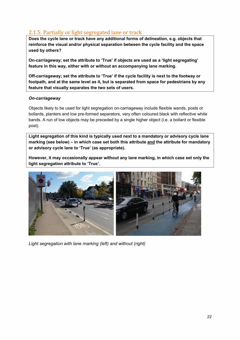
2.1.5. Partially or light segregated lane or track Does the cycle lane or track have any additional forms of delineation, e.g. objects that
reinforce the visual and/or physical separation between the cycle facility and the space
used by others?
On-carriageway; set the attribute to ‘True’ if objects are used as a ‘light segregating’
feature in this way, either with or without an accompanying lane marking.
Off-carriageway; set the attribute to ‘True’ if the cycle facility is next to the footway or
footpath, and at the same level as it, but is separated from space for pedestrians by any
feature that visually separates the two sets of users.
On-carriageway
Objects likely to be used for light segregation on-carriageway include flexible wands, posts or
bollards, planters and low pre-formed separators, very often coloured black with reflective white
bands. A run of low objects may be preceded by a single higher object (i.e. a bollard or flexible
post).
Light segregation of this kind is typically used next to a mandatory or advisory cycle lane
marking (see below) – in which case set both this attribute and the attribute for mandatory
or advisory cycle lane to ‘True’ (as appropriate).
However, it may occasionally appear without any lane marking, in which case set only the
light segregation attribute to ‘True’.
Light segregation with lane marking (left) and without (right)

23
Light segregation using planters and low pre-formed objects, with no lane marking
Note that a single flexible post or bollard is often used at the beginning of a segregating island, to
make the upstand more visible for all road users. Do not register instances such as these as very
short sections of light segregation.
Blank-faced bollard used at the beginning of a segregating island. This does not constitute
light segregation.
Signing for light segregated lanes may vary. If a mandatory cycle lane is present, it should have
the standard sign below. Other facilities may have the blue rectangular cycle route sign. Cycle
symbols are also likely to be present in the lane. The associated lane marking is also shown
below.
24
Off-carriageway
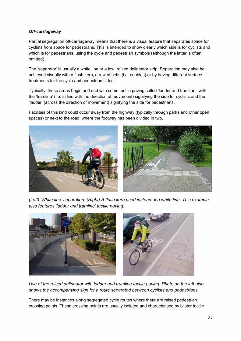
Partial segregation off-carriageway means that there is a visual feature that separates space for
cyclists from space for pedestrians. This is intended to show clearly which side is for cyclists and
which is for pedestrians, using the cycle and pedestrian symbols (although the latter is often
omitted).
The ‘separator’ is usually a white line or a low, raised delineator strip. Separation may also be
achieved visually with a flush kerb, a row of setts (i.e. cobbles) or by having different surface
treatments for the cycle and pedestrian sides.
Typically, these areas begin and end with some tactile paving called ‘ladder and tramline’, with
the ‘tramline’ (i.e. in line with the direction of movement) signifying the side for cyclists and the
‘ladder’ (across the direction of movement) signifying the side for pedestrians.
Facilities of this kind could occur away from the highway (typically through parks and other open
spaces) or next to the road, where the footway has been divided in two.
(Left) ‘White line’ separation. (Right) A flush kerb used instead of a white line. This example
also features ‘ladder and tramline’ tactile paving.
Use of the raised delineator with ladder and tramline tactile paving. Photo on the left also
shows the accompanying sign for a route separated between cyclists and pedestrians.
There may be instances along segregated cycle routes where there are raised pedestrian
crossing points. These crossing points are usually isolated and characterised by blister tactile

25
paving (dots) along the full width of the crossing. If so, the small section of flush cycle track at the
crossing point does not create a separate partially segregated asset; the cycle track continues
across.
Note the segregated cycle track that ramps up right before the tactile and ramps down
straight after; tactile paving is present for the whole width of the crossing point.
If instead the cycle track is flush with the footway and does not have tactile paving for the whole
length of the flush section it will be recorded as a separate asset, partially segregated and off-
carriageway.

26
Note the section of cycle track flush with the footway with tactile paving for a partial length
only. The flush section is recorded as separate asset, off-carriageway and partially
segregated.
2.1.6. Shared lane or footway Do signs show that cyclists can share a facility that primarily exists for a different user?
For on-carriageway, set the attribute to ‘True’ if there is a bus lane that cyclists can use.
For off-carriageway, set the attribute to ‘True’ if there is a footway, footpath or other area
of public space that is shared between pedestrians and cyclists (i.e. where the space is
not divided between different users).
On-carriageway (bus lanes)
Bus lanes are marked with a solid, wide lane marking, are identified with the words ‘bus lane’ and
have the accompanying sign showing which users are allowed in the lane and the times of
operation of the lane. Shared bus lanes should have the mandatory and advisory attributes set to
‘False’.
Many, but not all bus lanes, are coloured red – this has no bearing on what type of facility it is.
Bus lanes have no cycle symbols marked in them, apart from contraflow bus/cycle lanes (which
have ‘bus and cycle only’ written in them).

27
Standard bus lane marked with ‘Bus Lane’ only plus signs
Contraflow bus lanes marked with ‘Bus and Cycle only’
A cycle lane may occasionally appear within or adjacent to a bus lane (usually on the left of near
side).
Where the cycle lane adjacent to a bus lane is mandatory it should be recorded as a
mandatory lane. If it has light segregation this attribute also be entered as ‘True’.
Where the cycle lane is advisory the attributes for advisory lane and shared lane should
be set to ‘True’.
Mandatory cycle lane on nearside of bus lane
28
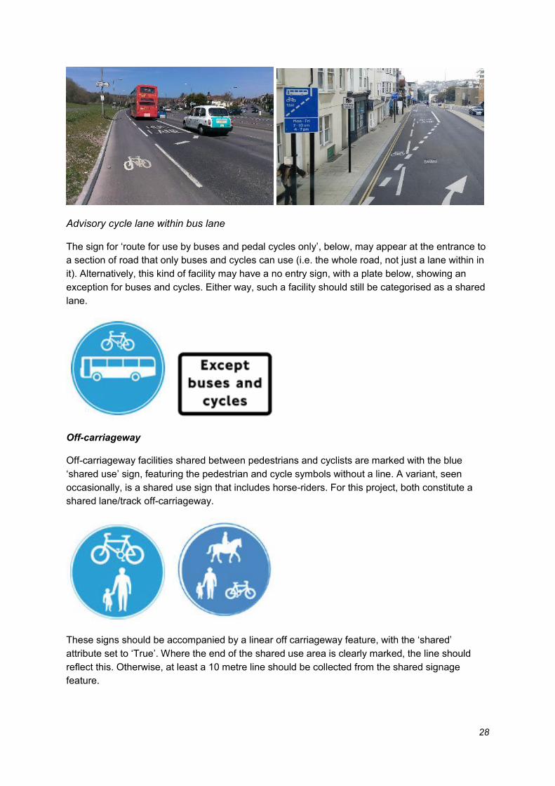
Advisory cycle lane within bus lane
The sign for ‘route for use by buses and pedal cycles only’, below, may appear at the entrance to
a section of road that only buses and cycles can use (i.e. the whole road, not just a lane within in
it). Alternatively, this kind of facility may have a no entry sign, with a plate below, showing an
exception for buses and cycles. Either way, such a facility should still be categorised as a shared
lane.
Off-carriageway
Off-carriageway facilities shared between pedestrians and cyclists are marked with the blue
‘shared use’ sign, featuring the pedestrian and cycle symbols without a line. A variant, seen
occasionally, is a shared use sign that includes horse-riders. For this project, both constitute a
shared lane/track off-carriageway.
These signs should be accompanied by a linear off carriageway feature, with the ‘shared’
attribute set to ‘True’. Where the end of the shared use area is clearly marked, the line should
reflect this. Otherwise, at least a 10 metre line should be collected from the shared signage
feature.

29
This sign is used for every shared use facility within the highway, i.e. next to the road. There may
be some instances, however, where the sign is not mounted on a post, but on a bollard or other
street furniture, or even embedded into the footway surface.
Signs on bollards showing that the bridge is shared use
Shared use areas are often found either side of a toucan crossing (left) or between areas
separated between pedestrians and cyclists (right), often because there needs to be more
complex movements in those areas.
Most canal towpaths are shared use unless otherwise stated. There may be long stretches
without a sign or any other indication that cycling is permitted.
30
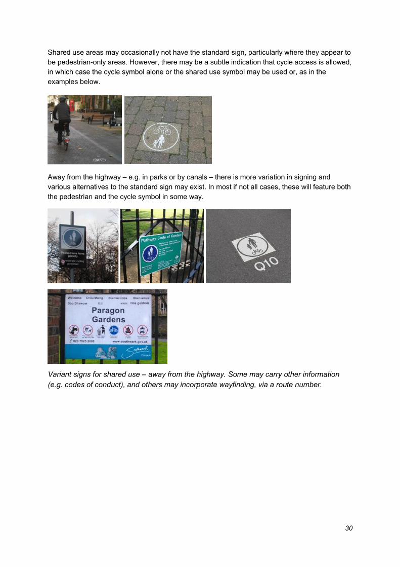
Shared use areas may occasionally not have the standard sign, particularly where they appear to
be pedestrian-only areas. However, there may be a subtle indication that cycle access is allowed,
in which case the cycle symbol alone or the shared use symbol may be used or, as in the
examples below.
Away from the highway – e.g. in parks or by canals – there is more variation in signing and
various alternatives to the standard sign may exist. In most if not all cases, these will feature both
the pedestrian and the cycle symbol in some way.
Variant signs for shared use – away from the highway. Some may carry other information
(e.g. codes of conduct), and others may incorporate wayfinding, via a route number.

31
2.1.7. Priority (On-carriageway only)
Does the cycle lane/track have priority over roads it meets or crosses? If so, set the
attribute to ‘True’.
Some cycle lanes (or bus lanes) on-carriageway stop at junctions, while others continue across
them. In the former case, these were recorded as separate features stopping at either side of the
junction.
However, where a lane continues across a side road with other vehicles expected to cross it, it
was recorded only where the side road is actually a highway and not where it is a private access.
Examples of cycle lane/track with priority:
The cycle lane that crosses the road but gives priority to cyclists must have a dashed line on its
right edge; therefore it was recorded as an advisory cycle lane with priority attribute set to true.
In instances as shown below where a cycle lane/track crosses a road and traffic on the road is
expected to give way, this were drawn as a crossing (between the kerbs) and the priority attribute
is not set.
32
Give way road markings on the carriageway either side of the bi-directional cycle lane shows
that traffic should give way to cyclists using the facility
2.1.8. Contraflow lane/track
On-carriageway
Does the cycle facility run in the opposite direction to the adjacent general traffic lane? If
so, set both this and the on-carriageway attributes to ‘True’.
There is an exception for two-way cycle lanes on one side of a road. In that case, see
‘Bidirectional’ below - do not set the ‘Contraflow’ attribute to ‘True’.
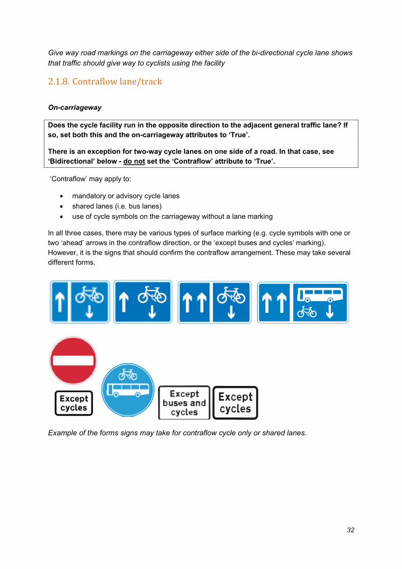
‘Contraflow’ may apply to:
• mandatory or advisory cycle lanes
• shared lanes (i.e. bus lanes)
• use of cycle symbols on the carriageway without a lane marking
In all three cases, there may be various types of surface marking (e.g. cycle symbols with one or
two ‘ahead’ arrows in the contraflow direction, or the ‘except buses and cycles’ marking).
However, it is the signs that should confirm the contraflow arrangement. These may take several
different forms.
Example of the forms signs may take for contraflow cycle only or shared lanes.

33
Example of contraflow cycle lanes, marked along the length of the road
Where there is only a short entry lane (as shown above), or none at all, the feature should
be drawn as a line over the length of the contraflow section and the attributes mandatory
and advisory will both be entered as “False”.
Example of contraflow cycle lanes, marked only at entrance/exit with associated signage
Off-carriageway
Does the cycle facility run in one direction only in the opposite direction to the adjacent
general traffic lane? If so, set only the attribute to ‘True’. Also set the off-carriageway
attribute to ‘True’.
There is an exception for two-way cycle tracks on one side of a road. In that case, see
‘Bidirectional’ below and do not set the ‘Contraflow’ attribute to ‘True’.
In a small number of locations where road space is limited a contraflow facility has been provided
off-carriageway.
In these cases, it is generally the surface marking (e.g. cycle symbols with one or two ‘ahead’
arrows in the contraflow direction) that should confirm the contraflow arrangement. There are
often fewer signs than for on carriageway contraflows. However, there may also be signs at entry
and exit points.

34
Example of off-carriageway contraflow cycle tracks
2.1.9. Bi-directional Is the cycle lane/track or shared path bi-directional? If so, set the attribute to ‘True’.
Set the bi-directional attribute for all shared footpaths to ‘True’.
A bidirectional cycle lane or track is designed for cycles to move in both directions on the same
lane or track.
Examples of bi-directional cycle lanes, tracks and share paths
Dashed centreline markings and the cycle symbols show this is a bi-directional cycle lane

35
Give way markings and a cycle symbol at the end of this cycle track show it is bi-directional
2.1.10. Cycle bypass Is there a lane or track that enables cyclist to bypass traffic signals used by general
traffic? If so, set attribute to ‘True’.
Cycle bypasses allow cyclists to bypass signals for general traffic. Give way road markings at the
end of the bypass may indicate a bypass. Also, there will not be a traffic signal for the cyclists
(this is a cycle gate).
These were collected as separate lines to an ASL reservoirs, ASL feeder lanes or cycle lane
further along the road or across junctions. They should be lines of just a few meters in length.
Examples of a cycle bypass:

36
1.1.11. Continuous cycle facility through a bus stop Does the cycle lane or track continue through the bus stop area? If so, set attribute to
‘True’.
At most bus stops, cycle lanes or tracks end before the bus stop and starts again after. However,
at some, the cycle track carries on through the bus stop area – in which case the infrastructure
was recorded as a ‘continuous cycle facility through a bus stop’.
The main distinction between types is whether the cycle tracks runs behind or in front of the bus
stop:
Bus stop bypass (sometimes also known as a ‘floating bus stop’)
This is where a segregated track runs behind the bus stop, and passengers board from and alight
onto an island between the cycle track and the main carriageway. If a bus shelter is present, it is
located on the island. There is typically one or more designated crossing points for pedestrians to
access the island over the cycle track.
Some bus stop bypasses have the cycle track at the same level as the footway throughout (but
distinguished in some other way, e.g. different surface material or raised delineator) while in
others the cycle track is lower than the footway and island and ramps up only at the crossing
point(s).
Bus stop bypass on one-way cycle track
Bus stop bypass on two-way cycle track
Bus stop bypass with no footway to the rear Bus stop bypass with track at footway level

37
At most bus stop bypasses, the footway continues between the highway boundary and the cycle
track. However, there are examples of bus stop bypasses where there is no such section of
footway – pedestrians passing through have to cross over the cycle track to the island, walk
through the bus stop area and then cross back onto the main footway after the bus stop.
Cycle track bus boarder
This is where a cycle lane or track continues between the bus stop cage and the waiting area on
the footway for passengers. To board or alight from the bus, people have to step over the cycle
track, which is raised to the same level as the footway through the bus stop area. In some
examples, bus passengers step directly into the cycle track; in others, they step onto a buffer
zone between the bus stop cage and the cycle track.
(Note that these are distinct from ‘bus boarders’, which are build-outs from the kerb-line at the
bus stop, often where the existence of parking bays would make it difficult for the bus to pull in to
the kerbside. The term ‘cycle track bus boarder’ or ‘shared bus boarder’ is used because the
cycle track running through the bus stop effectively acts like a bus boarder when the bus is at the
stop.)
Cycle track bus boarder on a one-way track
Cycle track bus boarder on a two-way track
Cycle track bus boarder with a buffer zone
2.1.12. Park route Does the cycle lane/track pass through a park? If so, set attribute to ‘True’.

38
A park route may be on or off carriageway, a cycle track, shared path, or a road closed to general
traffic. This attribute were used wherever these apply to indicate that the route is within the park
grounds.
Examples of park routes
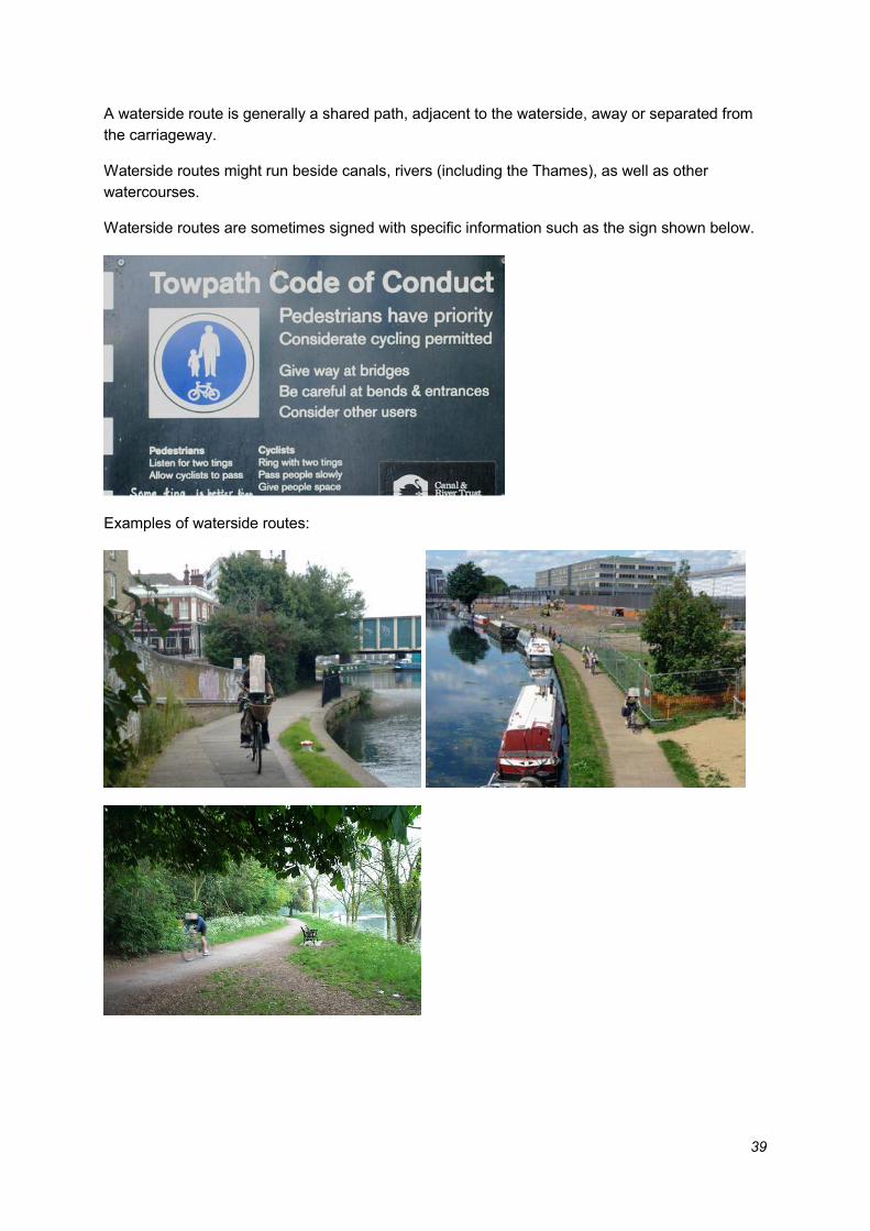
2.1.13. Waterside route Is the cycle lane/track by the waterside? If so, set attribute to ‘True’.
39
A waterside route is generally a shared path, adjacent to the waterside, away or separated from
the carriageway.
Waterside routes might run beside canals, rivers (including the Thames), as well as other
watercourses.
Waterside routes are sometimes signed with specific information such as the sign shown below.
Examples of waterside routes:
40
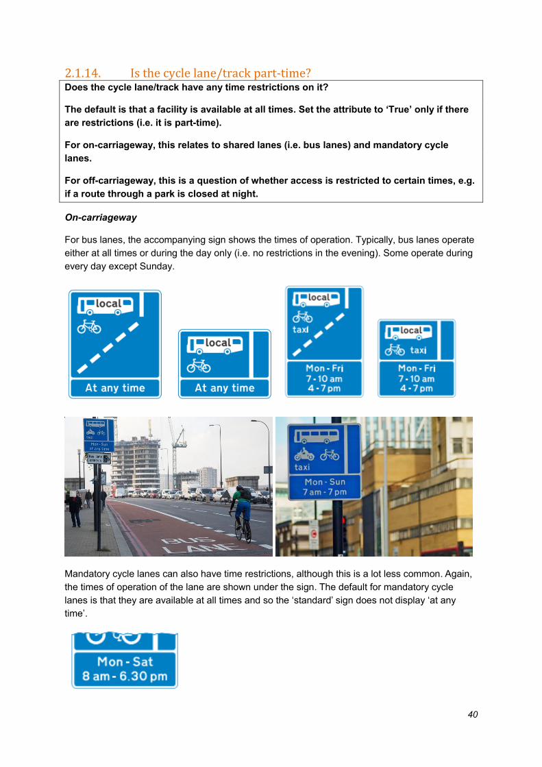
2.1.14. Is the cycle lane/track part-time? Does the cycle lane/track have any time restrictions on it?
The default is that a facility is available at all times. Set the attribute to ‘True’ only if there
are restrictions (i.e. it is part-time).
For on-carriageway, this relates to shared lanes (i.e. bus lanes) and mandatory cycle
lanes.
For off-carriageway, this is a question of whether access is restricted to certain times, e.g.
if a route through a park is closed at night.
On-carriageway
For bus lanes, the accompanying sign shows the times of operation. Typically, bus lanes operate
either at all times or during the day only (i.e. no restrictions in the evening). Some operate during
every day except Sunday.
Mandatory cycle lanes can also have time restrictions, although this is a lot less common. Again,
the times of operation of the lane are shown under the sign. The default for mandatory cycle
lanes is that they are available at all times and so the ‘standard’ sign does not display ‘at any
time’.

41
Off-carriageway
Some parks, canal towpaths and other green spaces may be gated and closed at night, in which
case entrances may display a sign showing the times of operation. These may not always be
immediately apparent and investigation of signs may be necessary to confirm if access if full- or
part-time.
Examples of park sign indicating part-time access
2.1.15. Access times Is the cycle facility closed at certain times or only available part time? If so, record details
of availability in this attribute, in text form.
The example below is a part time shared bus lane sign. The times would be recorded as “Mon -
Fri, 7-10am & 4-7pm”
For some routes and sites access times may vary at different times of the year. Surveyors
should only enter the start and finish times displayed when visited.
The example below is a park sign observed at different times of year. The closing time of the park
would be recorded either as “Park closes at 6.30pm” or “Park closes at 9.15pm”. However, as no
opening time is given the data entered should be “Park opening time unknown”.

42
2.1.16. Colour (Do not collect for shared footways)
What is the colour of the cycle lane or track surface? Enter the colour as text.
None (i.e. uncoloured surface)
Green
Blue
Red
Buff

43
2.2. Advance stop line (ASL) Advance stop lines are located at traffic signals and provide an area for cyclists to wait for the
traffic signals to change ahead of general traffic.
The ASL reservoir is the area between the solid stop line level with the lights and the stop line
further back for general traffic. The reservoir may have a coloured surface and have a cycle
symbol in the centre.
The diagram 1057 cycle symbols in ASLs were not recorded as signs as these are a required
feature of any ASL.
Where the carriageway splits at a junction and an ASL reservoir is visually or physically
separated into two parts by a refuge island, carriageway hatching or similar, two-line assets
should be recorded.
A feeder or lead-in lane is a short length of cycle lane connected to an ASL. Some ASLs have
multiple feeder lanes. In some cases longer cycle lanes/tracks act as feeder lanes.
ASLs were recorded as a linear feature from back to front of the reservoir aligned to the
kerb at approximately 1m from the kerb line.
Feeder lanes or longer approach cycle lanes were drawn separately as a cycle lanes/tracks
feature.

44
ASL with feeder lane
2.2.1. Feeder lane left Is there a feeder lane on the nearside/left of the ASL? If so, set attribute to ‘True’.
Attribute is set to ‘True’ if there is a near-side feeder lane, closest to the footway.
Some ASLs will have more than one feeder lane in which case the attribute for each type present
were set at ‘True’.
Short dashed lines called ‘gates’ are not a feeder
45
Left side lead-in lane
Short dashed ‘gate’ is not a feeder
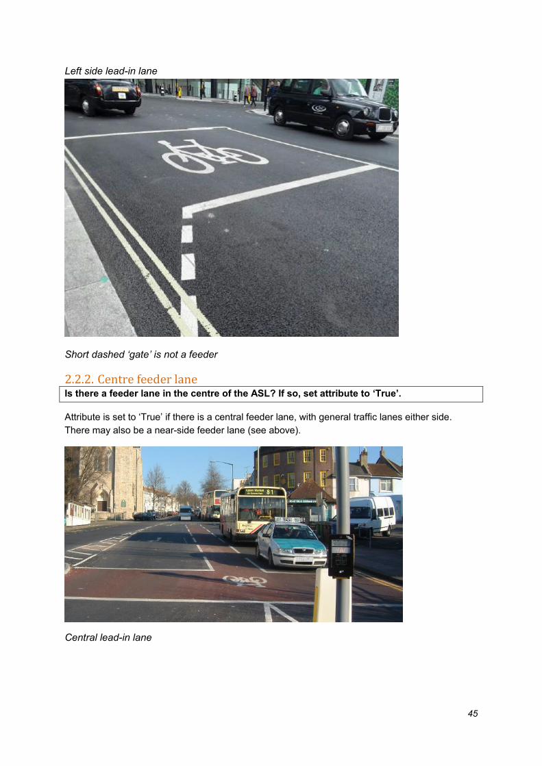
2.2.2. Centre feeder lane Is there a feeder lane in the centre of the ASL? If so, set attribute to ‘True’.
Attribute is set to ‘True’ if there is a central feeder lane, with general traffic lanes either side.
There may also be a near-side feeder lane (see above).
Central lead-in lane

46
2.2.3. Feeder lane right Is there a feeder lane on the far-side/right of the ASL? If so, set attribute to ‘True’.
Attribute is set to ‘True’ if the lane goes into the ASL on the far side of the road, adjacent to the
traffic lane for vehicles going in the opposite direction.
Right side lead-in lane
2.2.4. Shared nearside lane (SNSL) Is it a shared nearside lane? If so, set attribute to ‘True’.
A shared nearside lane is where a cycle lane or shared bus lane becomes a lane for general
traffic turning at a junction. These were collected as an advisory lane that is shared and drawn as
a cycle lane/track feature. The definition of a shared nearside lane is dependent on a colour
being applied to the whole of a traffic lane before an ASL. In addition, a shared nearside lane will
always be a left only or left and ahead lane
ASLs with shared nearside lane have the feeder attribute set to false.

47
Example of shared near-side lane; note the colour applied to the whole width of the lane and
simple ‘gate’ instead of feeder as entrance to the ASL.
2.3. Crossing Data were collected for crossings that are intended to be used by cyclists. Crossings may be
located at road junctions or in the middle of road links, between junctions.
This feature may include pedestrian-only crossings but only where they provide a link intended
for cyclists to use between signed cycle routes, e.g. shared footways on both sides of the road or
crossings over multi-lane, major or busy roads. These are generally indicated by cycle directions
signs plus “Cyclists Dismount” signing.
All crossing geometry was drawn from the edge of the kerb on one side to the edge of the kerb
on the other side of the road. If there is an island in the middle, e.g. a refuge island or a
staggered crossing, the line were drawn as one line following the route the cycle (or dismounted
cyclist) would take.
Only at-grade crossings were collected in this category of features. Subways, tunnels and
footbridges were collected in the restricted routes category.
2.3.1. Signal controlled crossing Is the crossing signal controlled? If so, set attribute to ‘True’.
Set this attribute to ‘False’ if it is a non-signal controlled crossing.
Both types of crossings can be at junctions or in the middle of road links.
Examples of the different types of crossings:

48
Signal controlled crossings
Non-signal controlled crossings
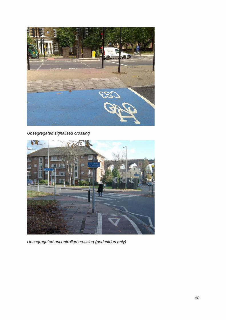
2.3.2. Segregated cycles and pedestrians Are cyclists and pedestrians kept separate on the crossing, or is the crossing for cyclists
only? If so, set attribute to ‘True’.
If cyclists and pedestrians share the crossing set attribute to ‘False’.
At segregated crossings cyclists and pedestrians are kept separate at the kerb and across the
road. These can be distinguished by different sets of push buttons (with cycle symbols only)
and/or ‘elephant foot print’ markings across the road parallel to the pedestrian crossing.
At unsegregated crossings cyclists and pedestrians share the crossing. These include both
crossings where cyclists can ride and those where they must dismount (see below).
Examples of segregated and unsegregated cycle and pedestrian crossings:

49
Segregated signalised crossings
Segregated uncontrolled crossing
50
Unsegregated signalised crossing
Unsegregated uncontrolled crossing (pedestrian only)
51
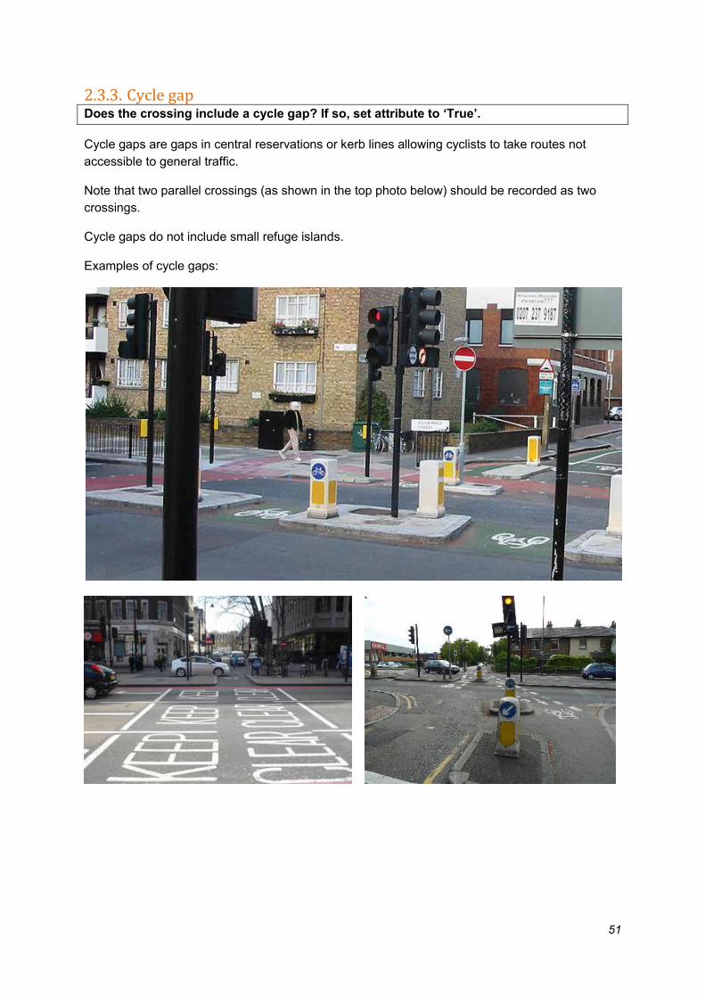
2.3.3. Cycle gap Does the crossing include a cycle gap? If so, set attribute to ‘True’.
Cycle gaps are gaps in central reservations or kerb lines allowing cyclists to take routes not
accessible to general traffic.
Note that two parallel crossings (as shown in the top photo below) should be recorded as two
crossings.
Cycle gaps do not include small refuge islands.
Examples of cycle gaps:

52
2.3.4. Pedestrian only crossing Is the crossing for pedestrians only, with cyclists required to dismount? If so, set attribute
to ‘True’.
Pedestrian only crossings were collected where they provide a link between cycle routes, e.g.
shared footways on both sides of the road or crossings over multi-lane, major or busy roads.
These crossings are often accompanied by “Cyclists Dismount” signing.
Example of pedestrian only crossings:
Zebra crossing – pedestrian only
Pelican crossing & pedestrian phase crossing at signal junctions – pedestrian only
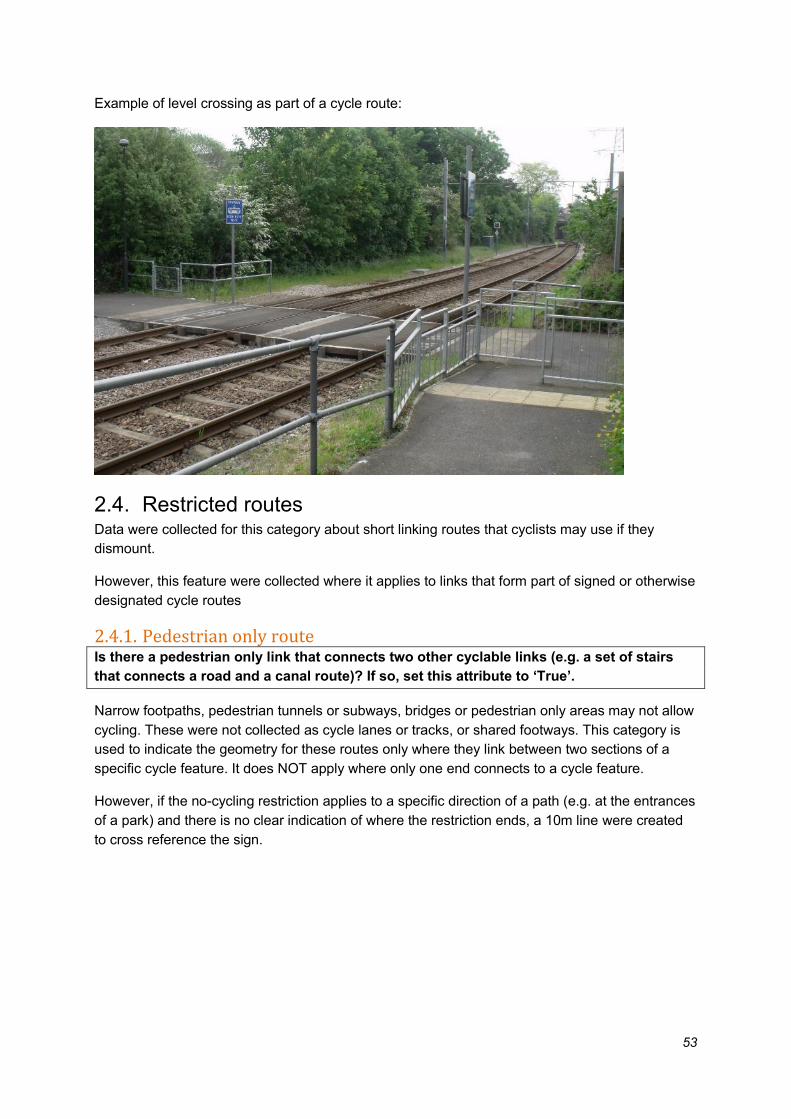
2.3.5. Level crossing Is the crossing a level crossing between two sections of cycle lane/track? If so, set
attribute to ‘True’.
53
Example of level crossing as part of a cycle route:
2.4. Restricted routes Data were collected for this category about short linking routes that cyclists may use if they
dismount.
However, this feature were collected where it applies to links that form part of signed or otherwise
designated cycle routes
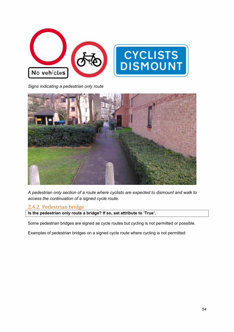
2.4.1. Pedestrian only route Is there a pedestrian only link that connects two other cyclable links (e.g. a set of stairs
that connects a road and a canal route)? If so, set this attribute to ‘True’.
Narrow footpaths, pedestrian tunnels or subways, bridges or pedestrian only areas may not allow
cycling. These were not collected as cycle lanes or tracks, or shared footways. This category is
used to indicate the geometry for these routes only where they link between two sections of a
specific cycle feature. It does NOT apply where only one end connects to a cycle feature.
However, if the no-cycling restriction applies to a specific direction of a path (e.g. at the entrances
of a park) and there is no clear indication of where the restriction ends, a 10m line were created
to cross reference the sign.
54
Signs indicating a pedestrian only route
A pedestrian only section of a route where cyclists are expected to dismount and walk to
access the continuation of a signed cycle route.
2.4.2. Pedestrian bridge Is the pedestrian only route a bridge? If so, set attribute to ‘True’.
Some pedestrian bridges are signed as cycle routes but cycling is not permitted or possible.
Examples of pedestrian bridges on a signed cycle route where cycling is not permitted:

55
2.4.3. Pedestrian tunnel Is the pedestrian-only route a tunnel or subway? If so, set attribute to ‘True’.
This was collected where the tunnel links two sections of a cycleable route.
Examples of pedestrian tunnel or subway on a signed cycle route where cycling is not permitted:

56
2.4.4. Steps Does the pedestrian only route include steps? If so, set attribute to ‘True’.
Where there is an existing cycle route which includes steps these were recorded as a separate
attribute, whether or not they form part of a longer restricted route such as a bridge (as shown
below).
Example of steps as part of a ‘cyclable route’ and could link a cycle route to the road network.
2.4.5. Lift Does the pedestrian only route include a lift? If so, set attribute to ‘True’.
Where there is an existing cycle route which includes a lift this were recorded as a separate
attribute, whether or not they form part of a longer restricted route such as a bridge.
Example of lift as part of a cycle route:

57
Point infrastructure Signs and road markings provide safety information for cyclists. They also guide cyclists along
routes, to routes where space has been designated for them (e.g. tracks inaccessible to other
vehicles), or to infrastructure that can support their journey (e.g. secure cycle parking).
Cycle parking provides a crucial service for cyclists at their start or destination.
Traffic calming can make cyclists’ trips better through reducing traffic speeds but can also affect
their ride quality.
This information is key to the wayfinding objective of the database – enabling us to identify
cycling routes across London.
3.1. Signs and markings Signs and markings are a priority attribute and key to the successful understanding of cycle
infrastructure across London. They provide information to cyclists about where they are going,
where they can/cannot cycle, and what space has been designated for their specific use adding
to the sense of safety and accessibility.
Only those signs relevant to cycling were collected as part of this project. In particular, these will
include signs and markings showing cycle symbols on.
There are also a number of exceptions (i.e. “Except Cyclists” signs). These are shown below
where appropriate.
3.1.1. Road/footway markings or signs Is the feature a marking, symbol or plaque on the road or footway? If so, set the attribute
to ‘True’.
If the feature is a sign or other item on a vertical backing, set the attribute to ‘False’.
Details were recorded about both cycle markings and signs. Markings include symbols, plaques
and other features on a surface road, including those on lanes, tracks or the footway.
All signage features with this attribute marked ‘False’ will be signs on posts, bollards or other
mountings. These can be symbols or wording.
Examples of cycle symbols:

58
3.1.2. Coloured patch Is the cycle symbol on a coloured patch? If so, set attribute to ‘True’.
This applies where cycle symbols or routes numbers are applied on a coloured background.
Record the colour in the colour attribute.
59
Example of coloured patches on CS3 (left) and CS7 (right)
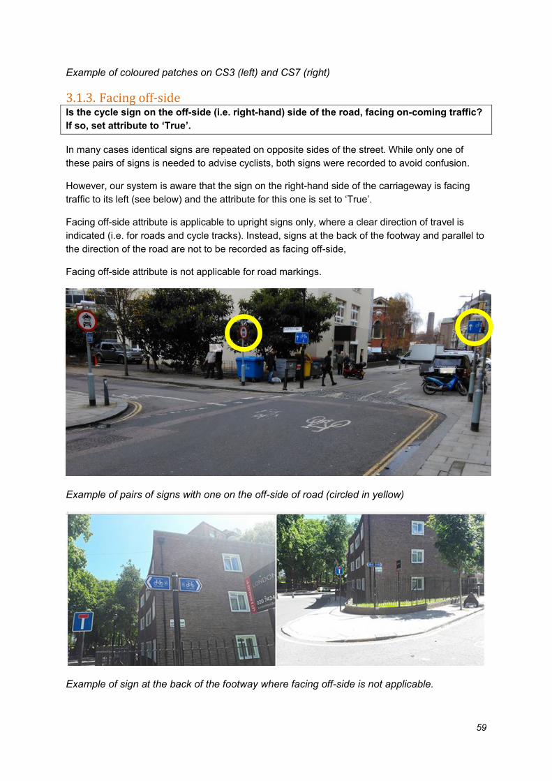
3.1.3. Facing off-side Is the cycle sign on the off-side (i.e. right-hand) side of the road, facing on-coming traffic?
If so, set attribute to ‘True’.
In many cases identical signs are repeated on opposite sides of the street. While only one of
these pairs of signs is needed to advise cyclists, both signs were recorded to avoid confusion.
However, our system is aware that the sign on the right-hand side of the carriageway is facing
traffic to its left (see below) and the attribute for this one is set to ‘True’.
Facing off-side attribute is applicable to upright signs only, where a clear direction of travel is
indicated (i.e. for roads and cycle tracks). Instead, signs at the back of the footway and parallel to
the direction of the road are not to be recorded as facing off-side,
Facing off-side attribute is not applicable for road markings.
Example of pairs of signs with one on the off-side of road (circled in yellow)
Example of sign at the back of the footway where facing off-side is not applicable.

60
3.1.4. Sign/symbol diagram number Is the marking one that is shown on the following list? If so, select the appropriate
marking or enter the marking number manually.
Diagram 1057 Diagram 1057.1 Diagram 955 (plaque on
surface) Diagram 956 (plaque on
surface)
Is the sign one that is shown on the following list? If so, select the appropriate sign or
enter the sign number manually.
Diagram 617 Diagram 619 Diagram 951 Diagram 866
Diagram 953 Diagram 953A Diagram 953B Diagram 953.1A
Diagram 955 Diagram 956 Diagram 956.1 Diagram 957

61
Diagram 958 Diagram 958.1 Diagram 959 Diagram 959.1
Diagram 960 Diagram 960.1 Diagram 960.2
Diagram 965 Diagram 966 Diagram 967
Diagram 2601.2 Diagram. 2602.2 Diagram 2602.3
The following signs have been superseded in TSRGD (2016) by the sign design system
described in Schedule 12. These signs should all be recorded as Diagram 2000.
Former Diagram
2601.1
Former Diagram
2602.1 (may omit
route number)
Former Diagram
2606
Diagram 2005.1 (may
omit route number)
Diagram 2105.1 (may
omit route number)
Diagram 2106.1 (may
omit route number)

62
Typical elements for cycle direction signs in the system set out in TSRGD (2016), Schedule
12 are shown below. All combinations of these should be recorded at Diagram 2000.
Part 2, item 8, ‘Sign placed on a road,
other than a motorway, showing routes for
cyclists’
Part 9, item 7, ‘Route
recommended for pedal
cyclists, together with a
national cycle route
number’
Part 11, item 3,
‘Route for pedal
cycles with an
indication of national
cycle route number
Does one of the signs shown below have a plate beneath (or next to) it with “Except
cycles” or a combination of “Except” and “cycles”? If so, select the appropriate sign or
enter the sign number manually.
The plate below may take one of the following forms. The rightmost three are found at traffic
signals only.
Diagram 606/609
(right)
Diagram 606/609
(left)
Diagram 612 Diagram 613
63
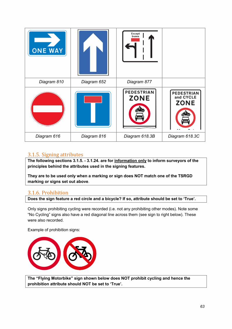
Diagram 810 Diagram 652 Diagram 877
Diagram 616 Diagram 816 Diagram 618.3B Diagram 618.3C
3.1.5. Signing attributes The following sections 3.1.5. - 3.1.24. are for information only to inform surveyors of the
principles behind the attributes used in the signing features.
They are to be used only when a marking or sign does NOT match one of the TSRGD
marking or signs set out above.
3.1.6. Prohibition Does the sign feature a red circle and a bicycle? If so, attribute should be set to ‘True’.
Only signs prohibiting cycling were recorded (i.e. not any prohibiting other modes). Note some
“No Cycling” signs also have a red diagonal line across them (see sign to right below). These
were also recorded.
Example of prohibition signs:
The “Flying Motorbike” sign shown below does NOT prohibit cycling and hence the
prohibition attribute should NOT be set to ‘True’.

64
“No motor vehicles” sign – cycling is permitted
Example of signs prohibiting cycling
3.1.7. No vehicles Is the sign a No vehicles sign? If so, attribute should be set to ‘True’.
This attribute applies where the sign face is a red circle with no symbols within it. It is sometimes
accompanied by the text sign No Vehicles. This includes pedal cycles.
If this route provides access to an area inaccessible by other routes or would provide a link to
other routes nearby then it was recorded as a restricted route (i.e. a pedestrian only link).
Note this may be operational part time, for example when part of a pedestrian zone. In this case
the access times were recorded in the Access Time attribute as described below.
Example of a No vehicles sign:

65
Example of part-time “No vehicles” signs allowing cycling at certain times (note right hand
sign would also have “Facing off-side” attribute set as ‘True’)
3.1.8. Circular or rectangular Is the sign circular? If so, attribute should be set to ‘True’.
Is the sign is square or rectangular? If so, attribute should be set to ‘False’.
If the sign is neither of the above (e.g. triangular signs) do not collect details for it, even if it shows
a cycle. These signs provide advice for drivers not cyclists and are therefore not of interest to this
survey. For further examples see the document “Know your signs”, image of “Pedal cycle route
crossing or joining road ahead”, page 36.
Examples of the circular and rectangular signs that were collected are shown below (NB this is
not a comprehensive list).
Example of rectangular signs. Commonly
used to indicate on carriageway facilities

66
Example of circular cycling signs. Commonly used to indicate off carriageway facilities (apart from bottom right used to indicate street used by buses & cycles only)
Example of rectangular cycle direction signs
3.1.9. Exemption sign Is there a sign with a plate below stating “Except cycles” or “Except buses and cycles”? If
so, attribute should be set to ‘True’.
The attribute relating to the specific exemption should also be recorded.
This attribute is used when there is an exemption sign, permitting cycle movements that general
traffic cannot make. This will be under (or rarely next to) other regulatory signs.
Where there are exceptions for cyclists the exception plate will always accompany another sign
with a restriction. The attribute set out by the sign which the exemption sign relates to should also
be recorded (e.g. “Banned Ahead” where a “No Entry” sign has “Except cycles” beneath).
Examples of “Except cycles” signs
67
3.1.10. Turning exceptions Turning exceptions are where turning movements for vehicles are restricted, with accompanying
signs. We are interested in banned turns where cycles are exempt from the banned movement as
this can improve safety (e.g. by stopping cars turning in front of cycles) or allow cycles to access
roads where other vehicles cannot do so.
Attribute information were collected about banned turns with cycle exceptions (as set out in
3.1.11. – 3.1.15.) The location of the point must be where the sign is placed.
3.1.11. Banned left turn Is there a no left turn sign with an “Except cycles” sign below? If so, attribute should be
set to ‘True’.
This attribute shall be marked ‘True’ if there is a no left turn sign present. Note the sign may be a
post, a bollard, a traffic signal or wall.
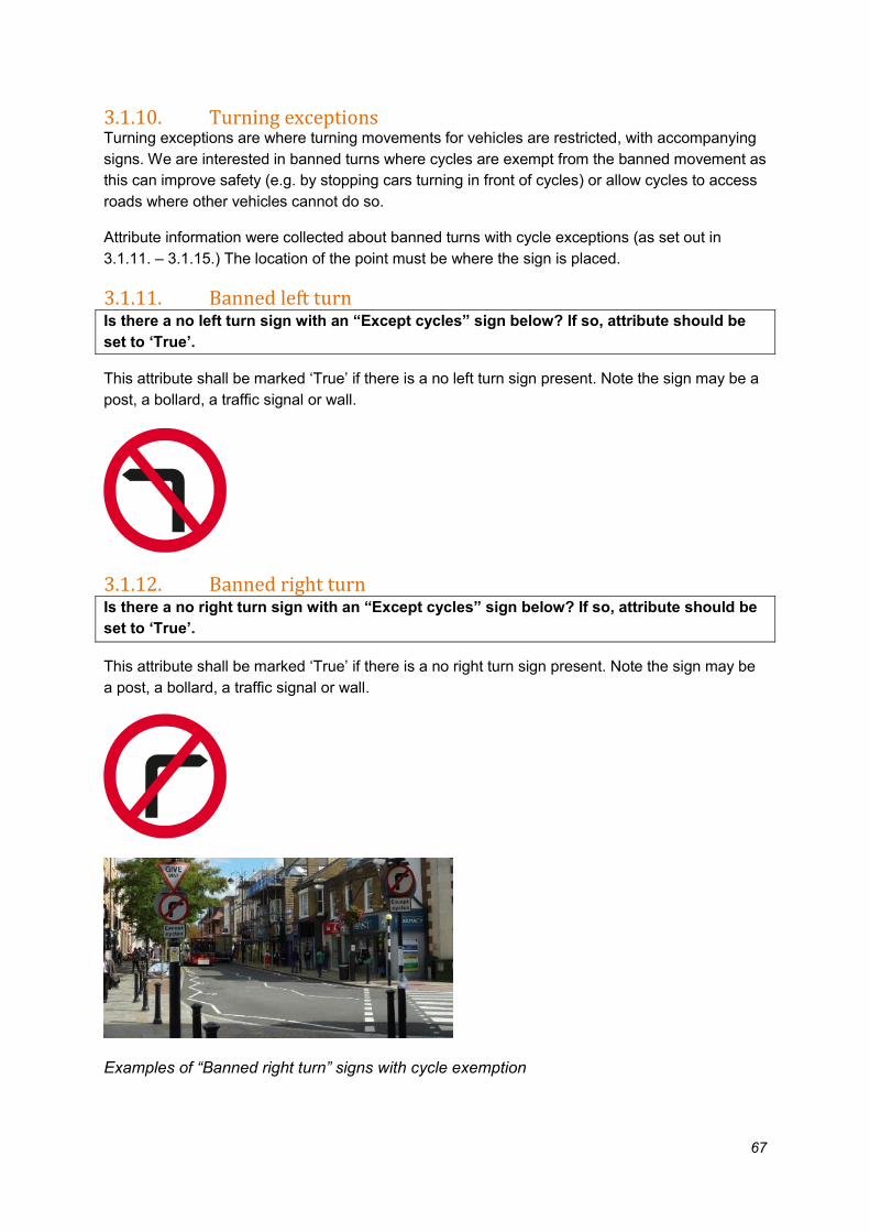
3.1.12. Banned right turn Is there a no right turn sign with an “Except cycles” sign below? If so, attribute should be
set to ‘True’.
This attribute shall be marked ‘True’ if there is a no right turn sign present. Note the sign may be
a post, a bollard, a traffic signal or wall.
Examples of “Banned right turn” signs with cycle exemption

68
3.1.13. Compulsory left turn Is there an arrow pointing left sign with an “Except cycles” sign below? If so, attribute
should be set to ‘True’.
This attribute shall be marked ‘True’ if there is a compulsory left turn sign present. Note the sign
may be a post, a bollard, a traffic signal or wall.
Examples of “Compulsory left turn” sign with cycle exemption
3.1.14. Compulsory right turn Is there an arrow pointing right sign with an “Except cycles” sign below? If so, attribute
should be set to ‘True’.
This attribute shall be marked ‘True’ if there is a compulsory right turn sign present. Note the sign
may be a post, a bollard, a traffic signal or wall.

69
3.1.15. Banned ahead Is access to the road ahead banned, except for cycles? If so, attribute should be set to
‘True’.
There are a variety of circumstances where general traffic is restricted from travelling ahead in
some way, while cycles are allowed.
These can include “No entry” or “No through road” signs with cycle exemptions. They can also
include a Pedestrian zone sign or “No motor vehicle” sign indicating that motor traffic is not
permitted to enter an area.
Banned ahead signing is generally found at signalised and un-signalised junctions and at cross
roads. It can also be found at road closures where cycles are allowed to pass through.
No entry No through road Lane ahead closed to
general traffic
Pedestrian zone sign No motor vehicles
Examples of the information we are looking to capture with this attribute:

70
3.1.16. Cyclists dismount Is the sign a “Cyclists dismount” sign? If so, attribute should be set to ‘True’.
3.1.17. End of Route Is the sign an “End of route” sign? If so, attribute should be set to ‘True’.
Signs stating “End of bus lane” should not be recorded.

71
3.1.18. Cycle symbol Does the sign have a cycle symbol or the word cycle/cyclist/cycling’ etc. on it, or is the
road marking a cycle symbol? If so, attribute should be set to ‘True’.
Where the sign face features a cycle symbol or if there is a cycle symbol marked on the ground
i.e. path, footway or road. Only pedal cycle symbols were collected.
The words cycle/cycles etc. on a sign, marking or exception plate will result in the cycle symbol
attribute being set to true.
Cycle sign and symbol
Note some signs with cycle symbols are excluded, such as cycle parking signs.
Also signs informing of the presence of a cycle lane ahead (diag. 962.1 and 962.2) are NOT to be
recorded.
These signs (diag. 962.1 and 962.2) are NOT to be recorded

72
3.1.19. Pedestrian symbol Does the sign have a pedestrian symbol on it, in addition to a cycle symbol? If so,
attribute should be set to ‘True’.
The pedestrian symbol may appear on signs or on the footway as a road marking. It may appear
below a cycle symbol or to the sign of it.
This attribute were only collected where used in conjunction with pedal cycle symbols or text.
3.1.20. Bus symbol Does the sign have a bus symbol or the word ‘bus/buses’ etc. on it, as well as a cycle
symbol? If so, set attribute to ‘True’.
Where the sign face features a bus symbol or the word bus, if there is a bus symbol or the word
bus marked on the ground.
This attribute were only collected where used in conjunction with pedal cycle symbols or text.
The words bus/buses etc. in the sign or in the exemption plate will result in the bus symbol
attribute being set to true.
3.1.21. Other vehicle symbol Does the sign have another vehicle symbol or named vehicle on it, or a symbol of a horse,
as well as a cycle symbol? If so, set attribute to ‘True’.
This attribute shall be set to ‘True’ if the sign face features another vehicle for example a
motorcycle or the word taxi, if there is another vehicle symbol or the word describing another
vehicle marked on the ground e.g. taxi.
This attribute were only collected where used in conjunction with pedal cycle symbols or text.

73
3.1.22. Delineator Line on sign Does the sign feature a line separating the cycle symbol from other symbols? If so, set
attribute to ‘True’.
This indicates where there is a delineator marking the cycle infrastructure.
This is not used for the mandatory cycle lane sign or shared bus lane signs.
3.1.23. Direction arrow Does the sign feature both a cycle and an arrow or arrows? If so, set attribute to ‘True’.
This is to capture movements for cycles (e.g. contraflow signage). It should not be used for cycle
direction signs (including those with a chevron) or one-way or two-way general traffic signs.
3.1.24. Destination
Is the sign a direction sign or does it state a destination? If so, set attribute to ‘True’.
Examples of cycle direction signs:

74
This includes ‘map’ style signs as shown below.
Note that “stack” type signs should be recorded as a single sign, unless different route numbers
are present – the example below would be recorded as 1 feature.

75
Signed cycle routes stated as ‘alternative routes’ are also to be recorded
Example of alternative route sign
3.1.25. Number in box
Does the road marking or sign feature a number in a box? If so, set the attribute to ‘True’.
The boxed number on a cycle road marking or sign indicates a cycle route number.
Examples of different types of cycle route number:

76
3.1.26. National Cycle Network
Does the sign feature a red box with a number in it and/or the words National Cycle
Network? If so, set attribute to ‘True’.
National Cycle Network use red boxes with a number in to indicate the route. These may feature
on signs, fingerposts or destination signs, or stickers (commonly on lampposts). On signs
occasionally the word ‘Cycle’ is substituted for a cycle symbol.

77
National cycle network signs, route 11
National cycle network sticker, route 1
3.1.27. London Cycle Network
Does the sign feature a blue or clear box with a number in it and/or the words London
Cycle Network? Or is there a road marking with a boxed number? If so, set attribute to
‘True’.
London Cycle Network use blue or clear (no colour) boxes with a number in to indicate the route.
These may feature on signs, fingerposts or destination signs, or stickers (commonly on
lampposts). They may also be road markings. On signs occasionally the word ‘Cycle’ is
substituted for a cycle symbol.
London Cycle Network sign, route numbers 5
& 38
London Cycle Network road marking, route
4
3.1.28. Cycle Superhighway
Does the sign feature a pink box with a number in it and/or the words Cycle
Superhighway, or is there a road marking with the text CS and a number? If so, set
attribute to ‘True’.
Cycle Superhighways use pink boxes with a number in to indicate the route. These may feature
on signs, fingerposts or destination signs. They may also be road markings.

78
Signs in the form of “totems” bearing the Cycle Superhighway logo shown above should NOT be
collected.
These types of signs were not collected.

79
3.1.29. Quietway
Does the sign say Quietway or is there a road marking with a Q and a number? If so, set
attribute to ‘True’.
Examples of Quietway signs and road markings
In the case of the photo on the left above, this were collected as two signs recording separately
the details of the two numbered route signs in the middle as one is a Cycle Superhighway and
the other a Quietway.

80
3.1.30. Greenway
Does the sign say Greenway? If so, set attribute to ‘True’.
Example of a Greenway sign or marker. These may be signs on posts or footway markers.
Note that Greenway signs are relatively rare.
3.1.31. Route number What is the route number or numbers? Enter the route numbers as text.
Record the route number(s), including any preceding letters e.g. CS3 or Q1.
Where multiple routes are on a single sign face separate the values with a full stop and no
spaces (e.g. CS7.Q29).

81
3.1.32. Access times Does the sign state times of operation? If so, enter the details here as they appear on the
sign.
Sign showing part-time access (record as Mon-Sat, 7am-7pm)
3.2. Signals Details of signals were collected where there are specific benefits for cyclists; only those that
have been designed or reprogrammed so that the phasing gives advantage to cyclists and
improves their safety moving through the junction.
Note that signals can be found both at signalled junctions and certain crossings such as Toucans.
However, signals at Toucan crossings or cycle only crossings were not recorded as a point asset;
the linear asset (crossing) will already identify the presence of a signal when the relative attribute
is set to true (signal-controlled crossing).
The location of the point should be in the footway, on the side of the road for which the flow of
traffic the sign applies.
3.2.1. Cycle on signal head Is there an additional signal aspect (light), full set of cycle aspect signals or a low level
signal head for cycles? If so, set attribute to ‘True’.
Note that the signal head were only be recorded once (i.e. do not record the red, amber and
green symbols separately).
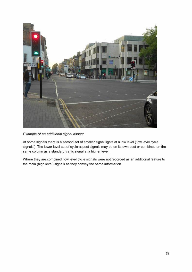
82
Example of an additional signal aspect
At some signals there is a second set of smaller signal lights at a low level (‘low level cycle
signals’). The lower level set of cycle aspect signals may be on its own post or combined on the
same column as a standard traffic signal at a higher level.
Where they are combined, low level cycle signals were not recorded as an additional feature to
the main (high level) signals as they convey the same information.

83
(left) Full set of lower level cycle only signals (right) Separate low level cycle signals
3.2.2. Separate stage for cycles Does the signal provide a separate stage for cycles? If so, set attribute to ‘True’.
At these locations’ cyclists will have a distinct time when they can move separate from general
traffic. This can be either at a junction where cyclists are sharing with general traffic, or where
cyclists have a separate lane/track on the approach.
Note this does not include ‘Early release’ (see below).
3.2.3. Early release Does the signal allow cyclists to get ahead or make movements through the junction
before other vehicles? If so, set attribute to ‘True’.
At these locations signal aspects for cyclists turn green a few seconds before the signals for
general traffic. This allows cyclists to move off earlier than other traffic and is therefore called
“Early release” or “Advance green”.
These signals are not a separate stage as there is a period where cyclists move with general
traffic.

84
3.2.4. Two stage turn Is there a sign on or near the signal saying cyclists should do a two stage turn?
This attribute applies where there is a sign telling cyclists to make do a two stage turn (usually to
the right) at the junction. Either the blue sign below or the exception sign will be present.
The two-stage turn should be recorded at the point where it starts.
3.2.5. Cycle Gate/Bus Gate Does the layout approaching the traffic lights hold general traffic whilst allowing cycles (or
cycles and other specified vehicles) to proceed to a forward stop line?
If so, set attribute to ‘True’.
For Cycle gates only, also set the Separate Cycle Stage attribute to ‘True’.
At these locations general traffic is held or released at a different stop line to cycles (and other
specified vehicles). Cycles (and in some cases other vehicles such as buses) have a separate
approach from other vehicles.

85
Note that that the gate traffic light was recorded separately from the main traffic light. The latter
were only recorded where it has a cycle aspect or stage.
Examples of a cycle/bus gate:
3.3. Traffic calming Traffic calming is infrastructure that is intended to reduce the speed of motor vehicles. It generally
comprises vertical and horizontal deflections. Traffic calming assets were only recorded for on-
carriageway features. For example, speed humps on fully segregated cycle lanes should not be
captured.
One geometry feature was created for each type of traffic calming infrastructure found. For
example, if there are three speed cushions across the carriageway, one-point feature were
created in the centre of the carriageway and ‘True’ recorded against the speed cushion attribute.
‘Optical’ traffic calming features (i.e. Made only through pavement change or paving) do not
constitute the remit of the survey as they are not vertical deflection. Optical traffic calming
features should not be recorded.
3.3.1. Raised table Is there a raised table at a junction? If so, set attribute to ‘True’.
Raised tables are normally found at road junctions. These can be at the intersection of three, four
or more arms.
A single point is placed at the centre of the junction between the roads affected.
Example of a raised table:

86
3.3.2. Raised side road entry treatment Is there a raised side road entry treatment? If so, set attribute to ‘True’.
Side road entry treatments are generally found where a side road or street meets a larger road.
At these locations the carriageway is raised to footway level. There are a number of different
types of treatment.
Note that treatments where the carriageway is NOT raised were not recorded.
A single point is placed in the middle of the carriageway, at the centre of where the side entry
treatment is located.
Examples of side road entry treatments:
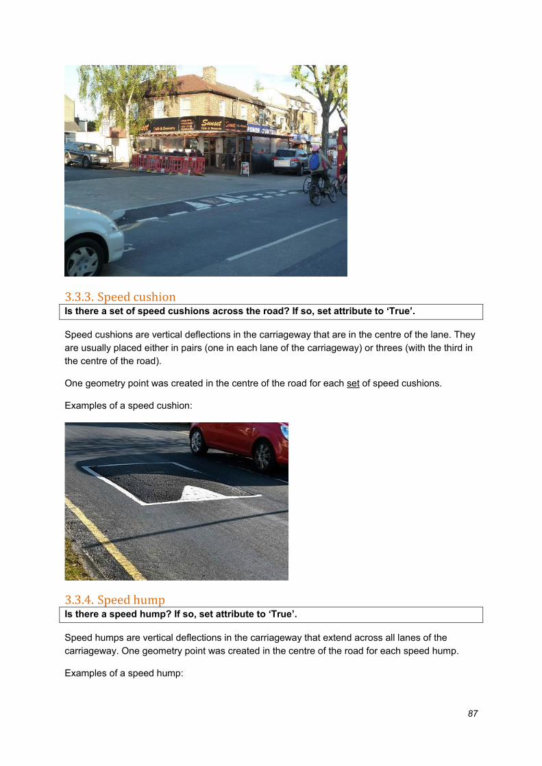
87
3.3.3. Speed cushion Is there a set of speed cushions across the road? If so, set attribute to ‘True’.
Speed cushions are vertical deflections in the carriageway that are in the centre of the lane. They
are usually placed either in pairs (one in each lane of the carriageway) or threes (with the third in
the centre of the road).
One geometry point was created in the centre of the road for each set of speed cushions.
Examples of a speed cushion:
3.3.4. Speed hump Is there a speed hump? If so, set attribute to ‘True’.
Speed humps are vertical deflections in the carriageway that extend across all lanes of the
carriageway. One geometry point was created in the centre of the road for each speed hump.
Examples of a speed hump:

88
3.3.5. Sinusoidal Is it a sinusoidal speed hump or speed cushion? If so, set attribute to ‘True’.
Note: this attribute should only be used if the speed cushion or speed hump attribute is
also set to ‘True’.
Sinusoidal related to the shape of the speed hump or speed hump. The sinusoidal shape is more
comfortable for cyclists than flat-topped ones.
Diagram of speed cushion or hump profiles:
Example of a sinusoidal speed hump:

89
3.3.6. Narrowings (including pinch points and chicanes) Are there build outs in the road to reduce vehicle speeds? If so, set attribute to ‘True’.
For example, this may be two build outs opposite each other to create a pinch point or a chicane
with changes to the priority of traffic flow. Build outs before or after parking spaces or for footway
widening should not be collected. One geometry point should be created in the centre of the
narrowing.
Examples of road narrowing:
Build outs for pinch point

90
(left) Pinch point with cycle lane (also record cycle lane)
(right) Chicane with signage showing the priority flow of traffic (record both cycle lanes)
3.3.7. Barrier Is there a barrier that cyclists can pass? If so, set attribute to ‘True’.
This attribute records locations where motor vehicles cannot pass but cyclists can; the
carriageway will continue but through traffic is blocked. It was only recorded for on carriageway
routes.
Example of a barrier that cyclists can pass:

91
3.3.8. Other traffic calming Is there another type of traffic calming infrastructure? If so, set attribute to ‘True’.
Where there is a type of traffic calming infrastructure found that does not meet the descriptions
above. It should be in the road and for the purpose of reducing vehicle speeds.
3.4. Miscellaneous point features
3.4.1. Steps Are there steps linking two cyclable routes (i.e. a cycle route and a road, two cycle routes
or any combination)? If so, set attribute to ‘True’.
This feature is only relevant where steps link routes where cycling is permitted. These steps will
be recorded as a point feature.
3.4.2. Lift Is there a lift linking two cycle routes? If so, set attribute to ‘True’.
An example of this is on the Olympic Park where a lift provides access to a cycle bridge over the
River Lea where cycling is permitted. These lifts will be recorded as a point feature.
3.5. Cycle Parking In the majority of cases cycle parking takes the form of a cycle stand or rack to which cycles can
be locked, in a variety of designs. In some locations cycle parking consists of lockers or a secure
compound.
There may also be signage pointing to where cycle parking is or at the location indicating what
the area is for (NB this signage data should NOT be captured).
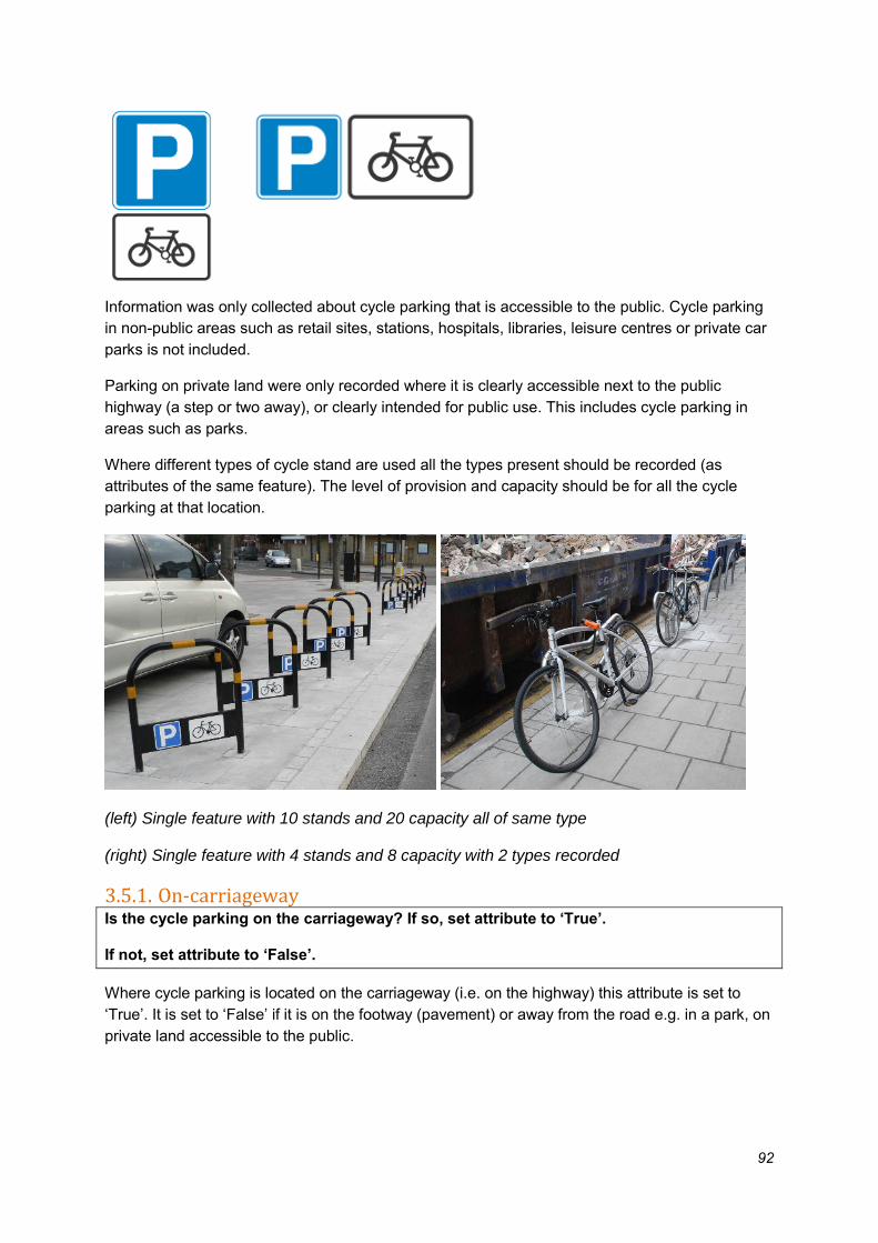
92
Information was only collected about cycle parking that is accessible to the public. Cycle parking
in non-public areas such as retail sites, stations, hospitals, libraries, leisure centres or private car
parks is not included.
Parking on private land were only recorded where it is clearly accessible next to the public
highway (a step or two away), or clearly intended for public use. This includes cycle parking in
areas such as parks.
Where different types of cycle stand are used all the types present should be recorded (as
attributes of the same feature). The level of provision and capacity should be for all the cycle
parking at that location.
(left) Single feature with 10 stands and 20 capacity all of same type
(right) Single feature with 4 stands and 8 capacity with 2 types recorded
3.5.1. On-carriageway Is the cycle parking on the carriageway? If so, set attribute to ‘True’.
If not, set attribute to ‘False’.
Where cycle parking is located on the carriageway (i.e. on the highway) this attribute is set to
‘True’. It is set to ‘False’ if it is on the footway (pavement) or away from the road e.g. in a park, on
private land accessible to the public.

93
On carriageway cycle parking
Off carriageway cycle parking
3.5.2. Covered Is the cycle parking under cover? If so, set attribute to ‘True’.
This attribute applies where the cycle parking is in a purpose-built facility i.e., under a shelter,
under a bridge or building overhang.
It does not apply to cycle parking on-street without shelter. In particular, cycle parking under trees
is not recorded as covered.
Where the cover is only partial, e.g. partly under a bridge, this is recorded as covered.
Examples of cycle parking that is covered / not covered:
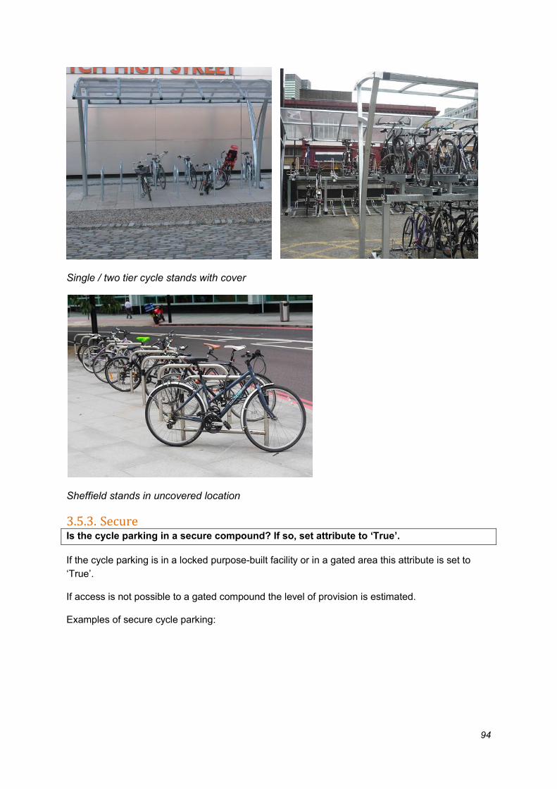
94
Single / two tier cycle stands with cover
Sheffield stands in uncovered location
3.5.3. Secure Is the cycle parking in a secure compound? If so, set attribute to ‘True’.
If the cycle parking is in a locked purpose-built facility or in a gated area this attribute is set to
‘True’.
If access is not possible to a gated compound the level of provision is estimated.
Examples of secure cycle parking:

95
Gated, monitored, lockable cycle parking area
Gated cycle parking compound
3.5.4. Locker Is the cycle parking in individual lockers? If so, set attribute to ‘True’.
If the cycle parking comprises one or more individual lockers this attribute is set to ‘True’.

96
Cycle lockers
3.5.5. Sheffield stand Does the cycle parking include Sheffield stands? If so, set attribute to ‘True’.
A Sheffield stand is the basic cycle parking stand. For the purposes of this project it is defined as
any symmetrical hoop or “upturned U” stand.
Colour, additional markings and a bar or rail across the middle are variations that is collected as a
Sheffield stand.
Example of a stands recorded as Sheffield stand:

97
3.5.6. M stand Does the cycle parking include M stands? If so, set attribute to ‘True’.
An ‘M stand’ is a variety of stand that resembles a letter M.
Example of a stands recorded as M stand:
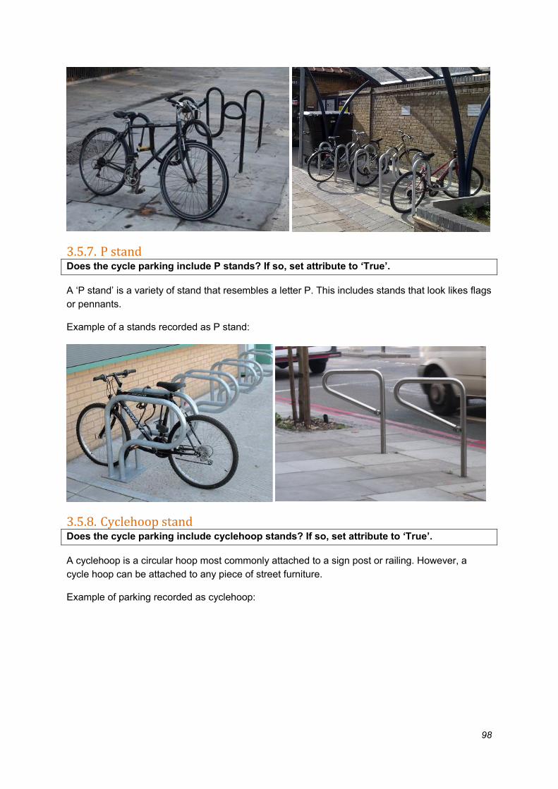
98
3.5.7. P stand Does the cycle parking include P stands? If so, set attribute to ‘True’.
A ‘P stand’ is a variety of stand that resembles a letter P. This includes stands that look likes flags
or pennants.
Example of a stands recorded as P stand:
3.5.8. Cyclehoop stand Does the cycle parking include cyclehoop stands? If so, set attribute to ‘True’.
A cyclehoop is a circular hoop most commonly attached to a sign post or railing. However, a
cycle hoop can be attached to any piece of street furniture.
Example of parking recorded as cyclehoop:
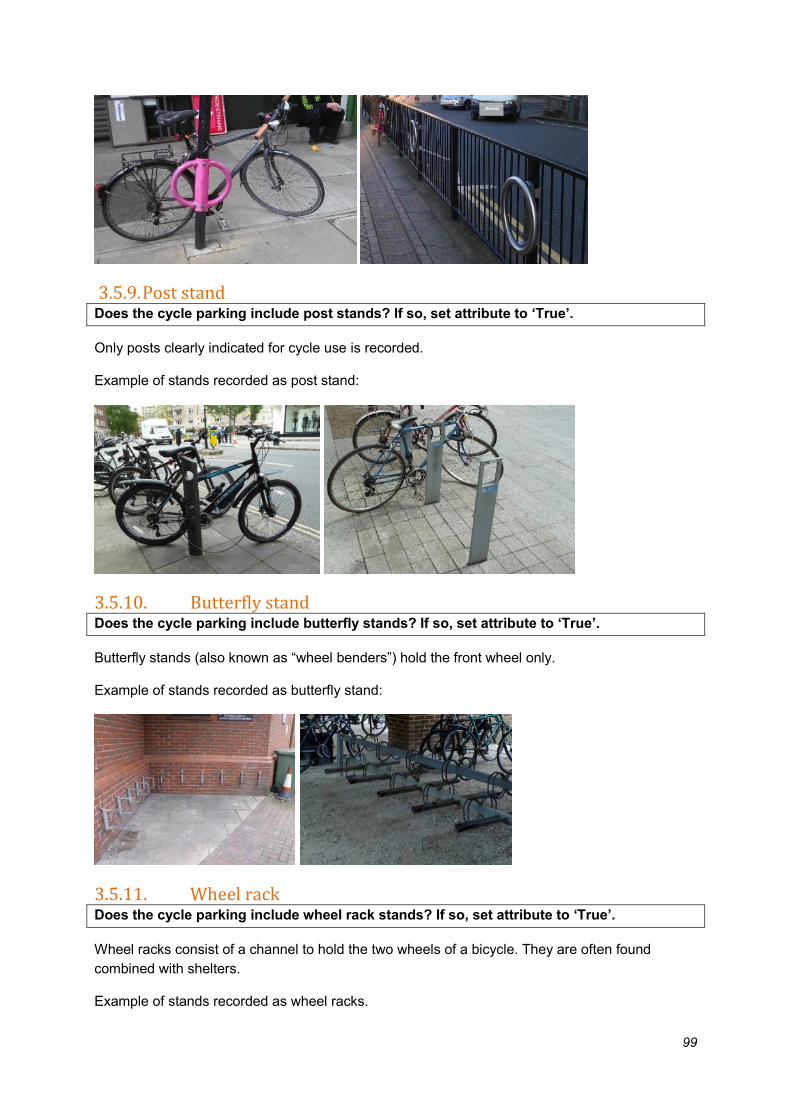
99
3.5.9. Post stand Does the cycle parking include post stands? If so, set attribute to ‘True’.
Only posts clearly indicated for cycle use is recorded.
Example of stands recorded as post stand:
3.5.10. Butterfly stand Does the cycle parking include butterfly stands? If so, set attribute to ‘True’.
Butterfly stands (also known as “wheel benders”) hold the front wheel only.
Example of stands recorded as butterfly stand:
3.5.11. Wheel rack Does the cycle parking include wheel rack stands? If so, set attribute to ‘True’.
Wheel racks consist of a channel to hold the two wheels of a bicycle. They are often found
combined with shelters.
Example of stands recorded as wheel racks.

100
3.5.12. Bike hangar Is the cycle parking a bike hangar? If so, set attribute to ‘True’.
If the bike hangar is on the road also set on-carriageway attribute to ‘True’.
Bike hangars are units which include both stands and a locked hinged cover. They are often sited
on the carriageway.
Example of stands recorded as bike hangars.
3.5.13. Two Tier Is the cycle parking two-tier stands? If so, set attribute to ‘True’.
Two tier parking has an upper level rack which slides out and down. They are generally found at
stations but a limited number are on or near roads.
Some two tier stands use a wheel rack system for cycle storage. In this instance, only the two-tier
attribute should be set to ‘True’.
Example of parking recorded as two-tier.

101
3.5.14. Other or unknown Is the cycle parking of other or unknown type? This attribute should be set to ‘True’ if the
cycle parking found does not match any of the types above.
3.5.15. Provision number How many cycle stands, frames or racks are there? Record the number of individual
stands or units.
The number of stands, frames or racks is recorded in this attribute.
For example, in the images below the provision number would both be recorded as 5 (Sheffield or
lockers).

102
In contrast, in the image below the provision number would be recorded as 1 (Sheffield toast rack
or bike hangar)
3.5.16. Capacity number How many cycles could be parked at the feature? The number of cycles that could easily
be parked at the cycle parking location is recorded in this attribute.
A decision will be needed on whether a cycle can be parked on one or both sides of the
frame/stand/rack when calculating capacity.
The number of bikes that can easily be parked is recorded in this attribute.
Where there is a tubular stand (e.g. Sheffield, M, P or hoop) these are recorded as having
provision for 2 cycles unless too close to the carriageway or a wall or other vertical feature. This
also applies if stands are too close together (this will generally be 600mm or closer, although
spacing should not be measured).
For example, in the images below the capacity number would be recorded as 10 (2 at each
Sheffield stand) or 5 (one bike in each locker).

103
In contrast, in the image below the provision number would be recorded as 8 (Sheffield toast
rack) or 1 (Sheffield stand too close to cabinet).