convective-scale data assimilation · luc fillion (environment canada), kazuo saito (jma/mri) ......
TRANSCRIPT
© Crown Copyright 2012. Source: Met Office
Dale Barker, with contributions from Met Office colleagues, and: Jelena Bolarova (HIRLAM), Yann Michel (Meteo France), Luc Fillion (Environment Canada), Kazuo Saito (JMA/MRI) THORPEX/DAOS Working Group Meeting 20 September 2012, UW, Madison, Wisconsin, USA
Convective-Scale Data Assimilation
© Crown Copyright 2012 Source: Met Office

© Crown Copyright 2012. Source: Met Office
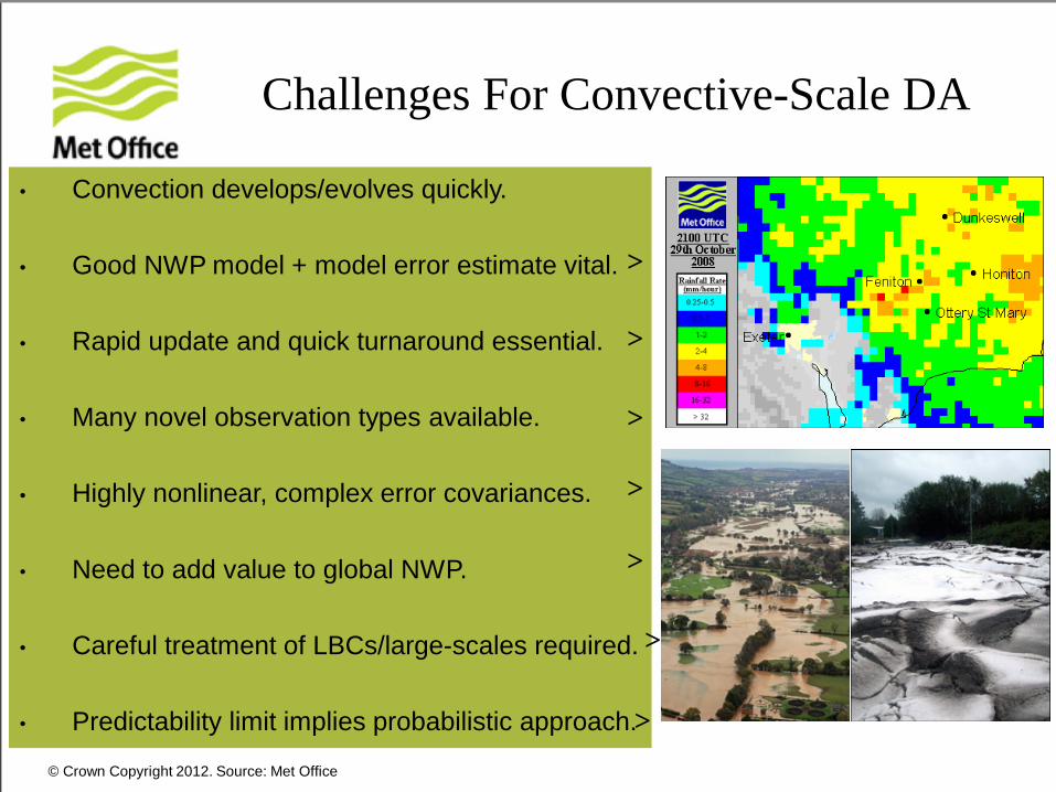
• Convection develops/evolves quickly.
• Good NWP model + model error estimate vital.
• Rapid update and quick turnaround essential.
• Many novel observation types available. • Highly nonlinear, complex error covariances.
• Need to add value to global NWP.
• Careful treatment of LBCs/large-scales required.
• Predictability limit implies probabilistic approach.
Challenges For Convective-Scale DA
>
>
>
>
>
>
>
© Crown Copyright 2012. Source: Met Office
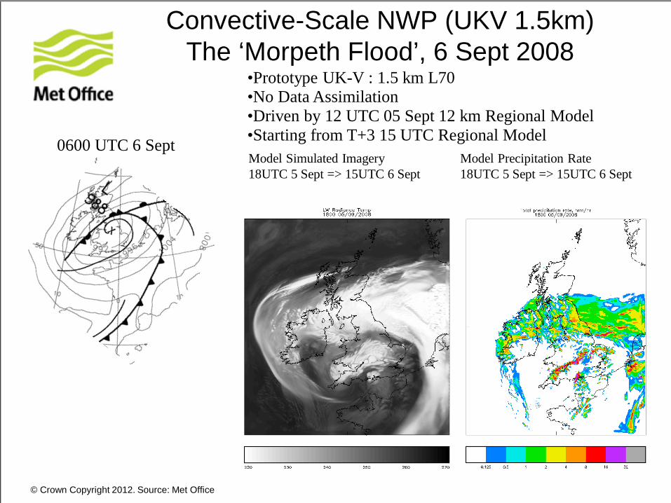
Convective-Scale NWP (UKV 1.5km) The ‘Morpeth Flood’, 6 Sept 2008
•Prototype UK-V : 1.5 km L70 •No Data Assimilation •Driven by 12 UTC 05 Sept 12 km Regional Model •Starting from T+3 15 UTC Regional Model 0600 UTC 6 Sept Model Simulated Imagery 18UTC 5 Sept => 15UTC 6 Sept
Model Precipitation Rate 18UTC 5 Sept => 15UTC 6 Sept

© Crown Copyright 2012. Source: Met Office
0.3
0.32
0.34
0.36
0.38
0.4
0.42
01/2004 01/2005 01/2006 01/2007 01/2008 01/2009 01/2010 01/2011Date
Equ
itabl
e Th
reat
Sco
refo
r >0.
5mm
pre
cipi
tatio
n
6121824
Forecast lead time (hrs)
18-hour forecast in Dec 2010 as good as 6-hour forecast in Dec 2007
6hr accumulated precip >= 0.5mm over UK
Improvements in UK Precipitation Forecasting at The Met Office
Bob Tubbs
© Crown Copyright 2012. Source: Met Office
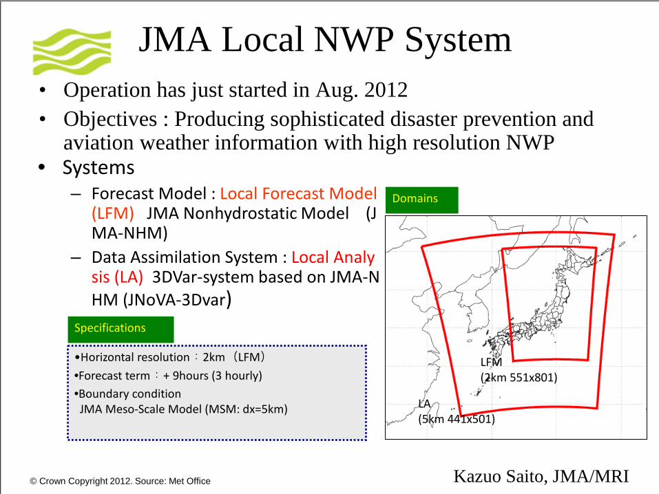
• Systems – Forecast Model : Local Forecast Model
(LFM) JMA Nonhydrostatic Model (JMA-NHM)
– Data Assimilation System : Local Analysis (LA) 3DVar-system based on JMA-NHM (JNoVA-3Dvar)
JMA Local NWP System • Operation has just started in Aug. 2012 • Objectives : Producing sophisticated disaster prevention and
aviation weather information with high resolution NWP
•Horizontal resolution:2km(LFM) •Forecast term:+ 9hours (3 hourly) •Boundary condition JMA Meso-Scale Model (MSM: dx=5km)
Specifications
LA (5km 441x501)
LFM (2km 551x801)
Domains
Kazuo Saito, JMA/MRI
© Crown Copyright 2012. Source: Met Office
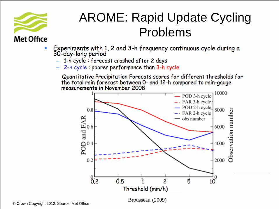
AROME: Rapid Update Cycling Problems
Brousseau (2009)
© Crown Copyright 2012. Source: Met Office
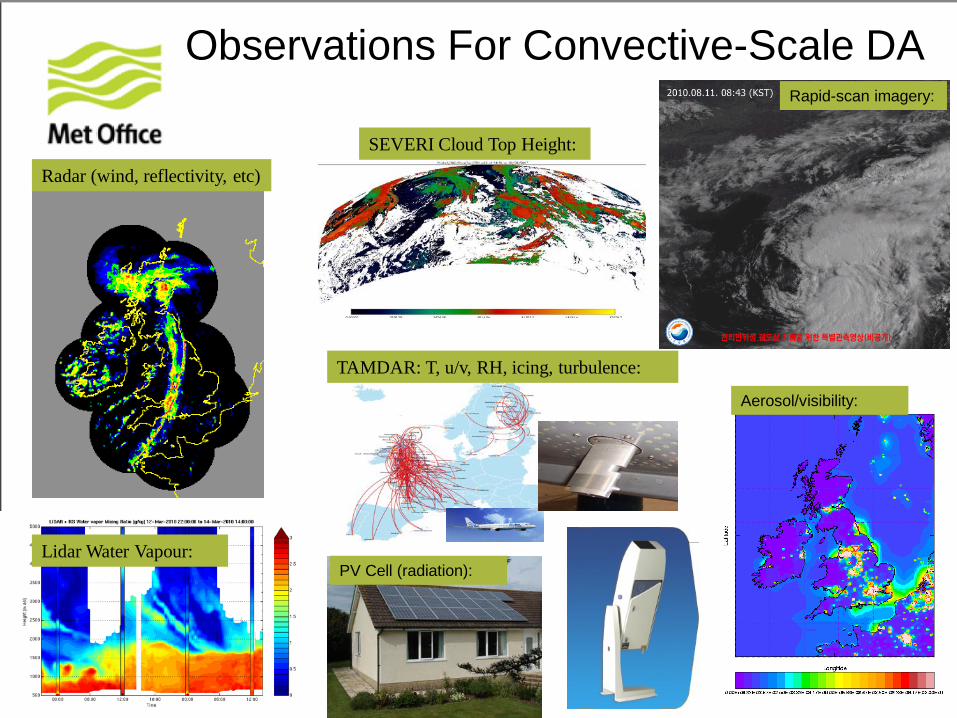
Observations For Convective-Scale DA Rapid-scan imagery:
TAMDAR: T, u/v, RH, icing, turbulence:
Lidar Water Vapour:
SEVERI Cloud Top Height:
Aerosol/visibility:
Radar (wind, reflectivity, etc)
PV Cell (radiation):
© Crown Copyright 2012. Source: Met Office
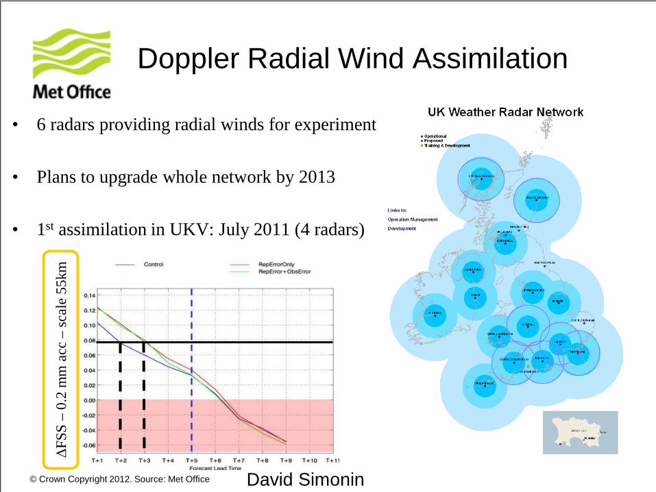
• 6 radars providing radial winds for experiment..
• Plans to upgrade whole network by 2013
• 1st assimilation in UKV: July 2011 (4 radars)
Doppler Radial Wind Assimilation ΔF
SS –
0.2
mm
acc
– sc
ale
55km
David Simonin
© Crown Copyright 2012. Source: Met Office
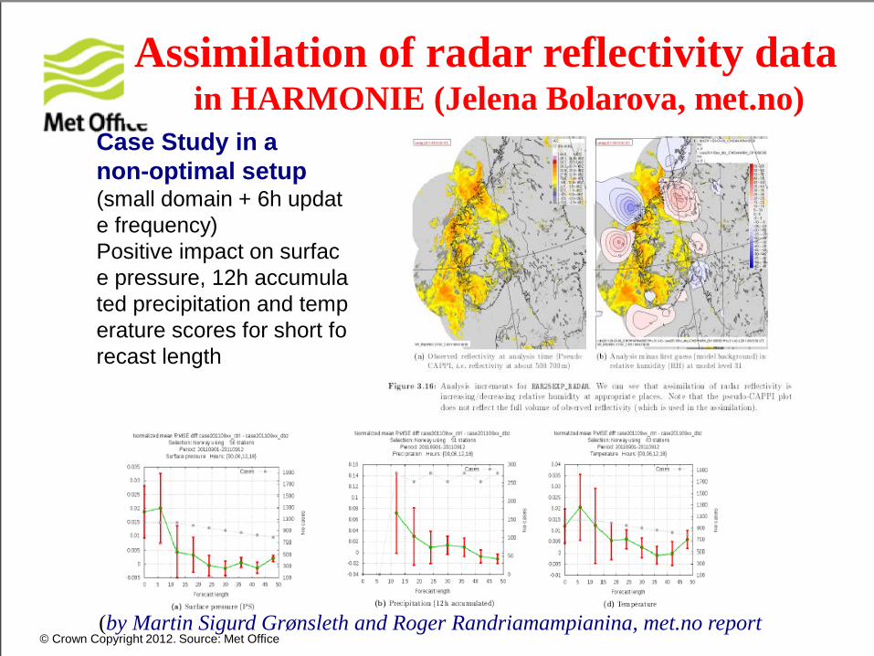
Assimilation of radar reflectivity data in HARMONIE (Jelena Bolarova, met.no)
(by Martin Sigurd Grønsleth and Roger Randriamampianina, met.no report
Case Study in a non-optimal setup (small domain + 6h update frequency) Positive impact on surface pressure, 12h accumulated precipitation and temperature scores for short forecast length
© Crown Copyright 2012. Source: Met Office
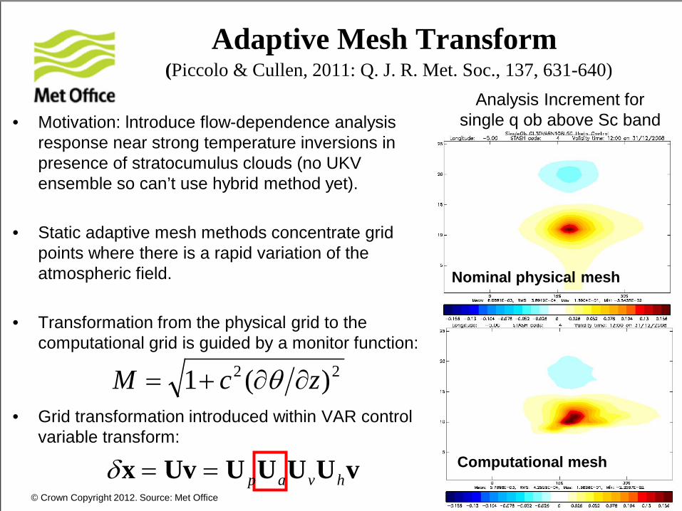
Adaptive Mesh Transform
• Motivation: lntroduce flow-dependence analysis response near strong temperature inversions in presence of stratocumulus clouds (no UKV ensemble so can’t use hybrid method yet).
• Static adaptive mesh methods concentrate grid points where there is a rapid variation of the atmospheric field.
• Transformation from the physical grid to the computational grid is guided by a monitor function:
• Grid transformation introduced within VAR control variable transform:
Computational mesh
Nominal physical mesh
Analysis Increment for single q ob above Sc band
δx = Uv = U pUaUvUhv
22 )(1 zcM ∂∂+= θ
(Piccolo & Cullen, 2011: Q. J. R. Met. Soc., 137, 631-640)

© Crown Copyright 2012. Source: Met Office
Iterative Calculation of Monitor Function
M (background-state - 3h forecast)
UK4 domain: 3 Jan 2011 00z
M (After 10 iteration 3D-Var) M (After 2nd converged 3D-Var)
Adaptive vertical grid provides a small positive impact to the UK index:
Period Vis Precip Cloud amount
Cloud base
Temp Wind Overall
23 Dec 2010 – 3 Jan 2011 -2.56% 5.48% -1.05% 3.03% 0.22% -0.04% +0.25%
10 Aug 2010 - 20 Aug 2010 12.20% 0.00% 0.00% 4.17% 0.23% 0.10% +0.55%
© Crown Copyright 2012. Source: Met Office
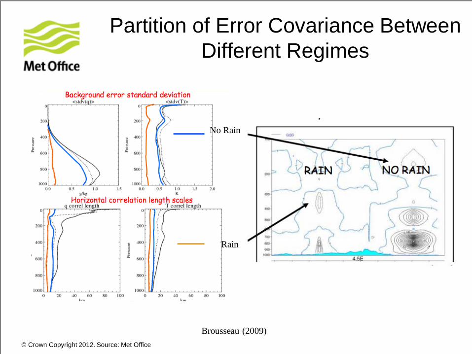
Partition of Error Covariance Between Different Regimes
Brousseau (2009)
No Rain
Rain
© Crown Copyright 2012. Source: Met Office
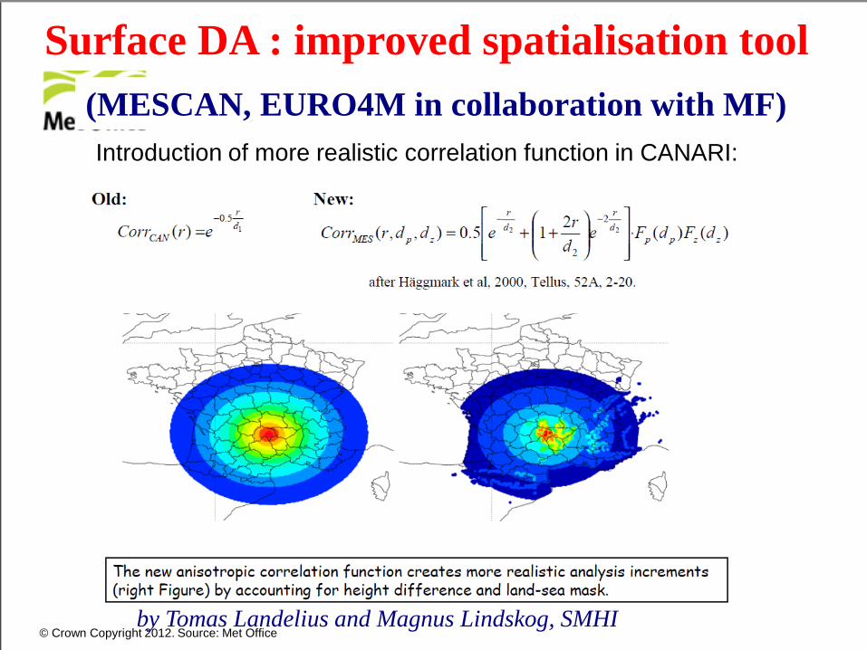
Surface DA : improved spatialisation tool (MESCAN, EURO4M in collaboration with MF) Introduction of more realistic correlation function in CANARI:
and then the status on the work in the following areas:
by Tomas Landelius and Magnus Lindskog, SMHI
© Crown Copyright 2012. Source: Met Office
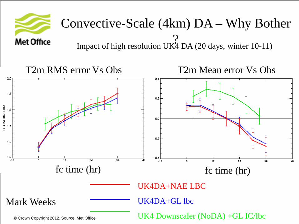
UK4DA+NAE LBC
UK4DA+GL lbc
UK4 Downscaler (NoDA) +GL IC/lbc
Impact of high resolution UK4 DA (20 days, winter 10-11)
T2m RMS error Vs Obs
fc time (hr)
Mark Weeks
fc time (hr)
T2m Mean error Vs Obs
Convective-Scale (4km) DA – Why Bother?
© Crown Copyright 2012. Source: Met Office
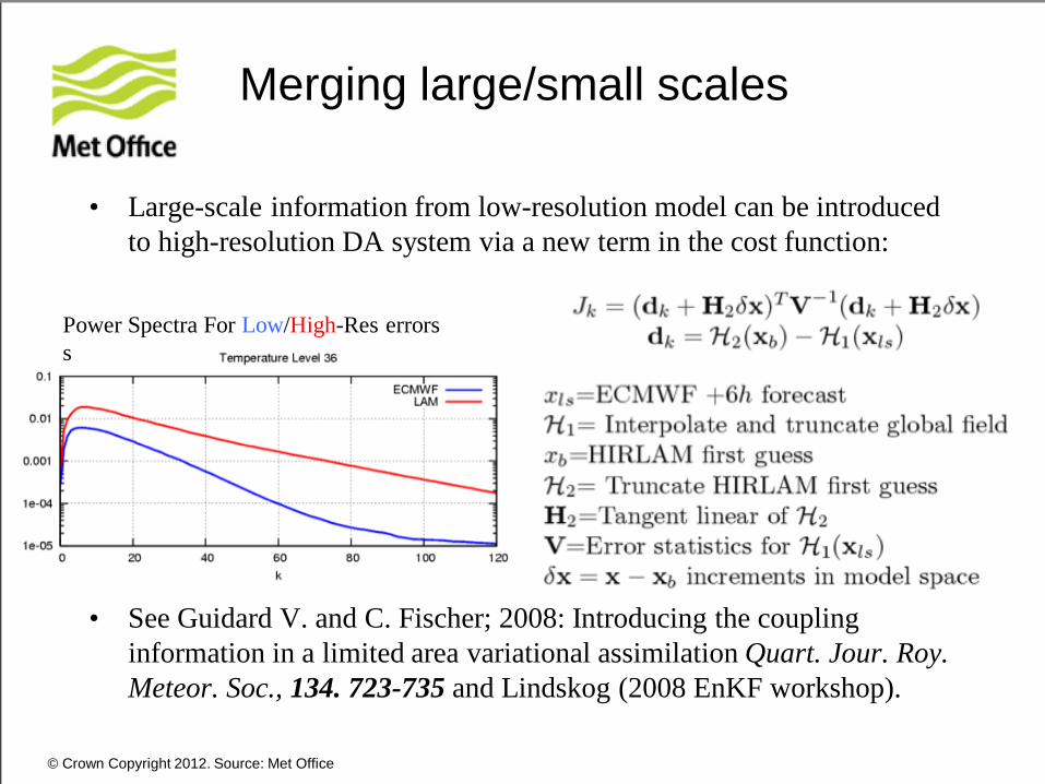
Merging large/small scales
• Large-scale information from low-resolution model can be introduced to high-resolution DA system via a new term in the cost function:
• See Guidard V. and C. Fischer; 2008: Introducing the coupling
information in a limited area variational assimilation Quart. Jour. Roy. Meteor. Soc., 134. 723-735 and Lindskog (2008 EnKF workshop).
Power Spectra For Low/High-Res errors s

© Crown Copyright 2012. Source: Met Office
2.2km Convective-Scale Ensemble Showcase for London 2012 Olympics
6 August 2012 Probability Of Torrential
Rain (>16mm):
• Availability of CS-scale EPS opens the door to CS-scale data assimilation
Wind Probabilities at Eton Dorney (Rowing):

© Crown Copyright 2012. Source: Met Office
Error Correlations With Single Reflectivity Ob
Shading : Full Fields Line Contours : Error Correlations
Tong and Zue (2005)
© Crown Copyright 2012. Source: Met Office
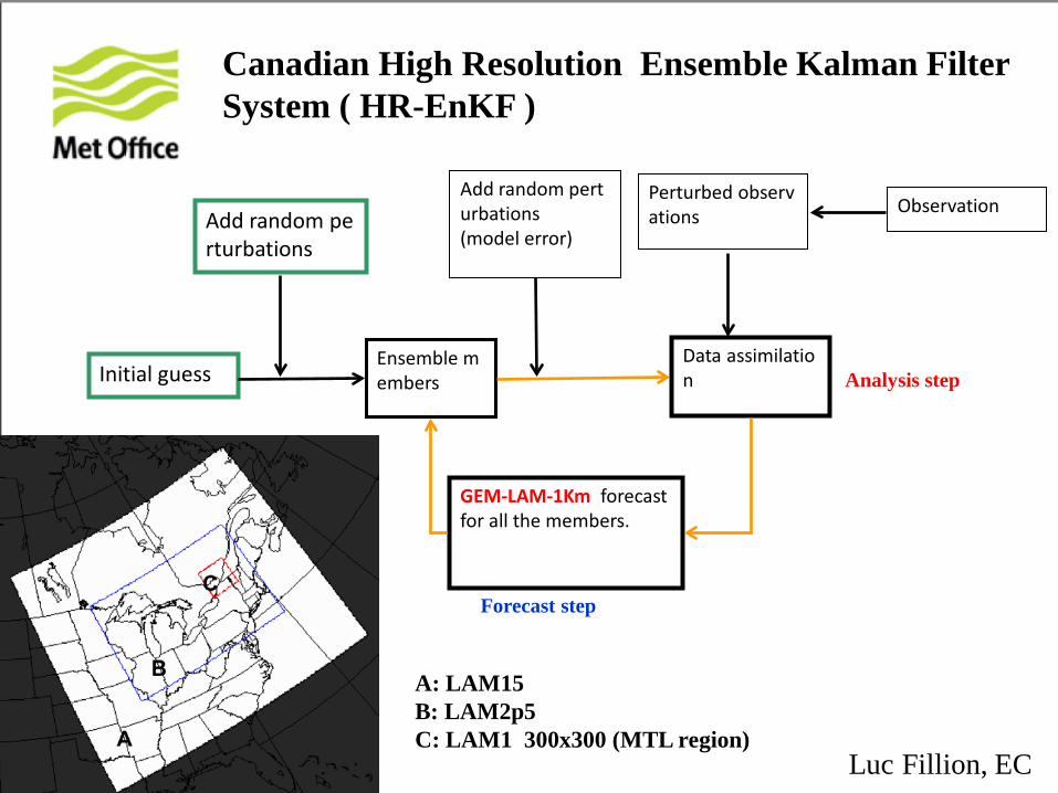
Initial guess Ensemble members
Add random perturbations
Data assimilation
Observation Perturbed observations
GEM-LAM-1Km forecast for all the members.
Add random perturbations (model error)
Analysis step
Forecast step
Canadian High Resolution Ensemble Kalman Filter System ( HR-EnKF )
A: LAM15 B: LAM2p5 C: LAM1 300x300 (MTL region)
Luc Fillion, EC
© Crown Copyright 2012. Source: Met Office
• Convection develops/evolves quickly.
• Good NWP model + model error estimate vital.
• Rapid update and quick turnaround essential.
• Many novel observation types available. • Highly nonlinear, complex error covariances.
• Need to add value to global NWP.
• Careful treatment of LBCs/large-scales required.
• Predictability limit implies probabilistic approach.
Challenges For Convective-Scale DA
>
>
>
>
>
>
>

© Crown Copyright 2012. Source: Met Office
Thank You!

© Crown Copyright 2012. Source: Met Office
Kessler warm rain process was implemented in LT/ADJ models.
4DVAR assimilation of • Doppler Radar’s Radial Winds • Radar Reflectivity • GPS precipitable water vapor • Surface observations (wind, temperature)
(Kawabata et al., 2011; Mon. Wea. Rev.)
JMA: Cloud resolving 4DVAR with cloud microphysics