continuing a legacy - woodhouse parish council of rushey lane, along forest road past the defence...
TRANSCRIPT

Continuing a Legacy
The design statement for Woodhouse


Woodhouse Village Design Statement
Contents
Map of Woodhouse Aerial view
Inside front coverInside back cover
Introduction The Planning Framework 3 Our Village 3 Why Produce a Village Design Statement? 3 Woodhouse – A Special Place and Conservation Area 4 How Woodhouse Developed 4
The Environment of Woodhouse Geology 5 Trees, Flora and Fauna 5 Landscape 6 Land Forms and Use 6 Village Setting - Visibility 7 Settlement Pattern 7 Movement 7
Guidelines 8
Buildings and Boundaries 10 Building Materials and Boundaries 11
The Influence of Beaumanor on Design 11 Renovation, Conversions and Extensions 13 New Development 14
Guidelines 14
Consultation and Appendices Consultation 17 Listed and special interest buildings 18
Results of Parish Plan Survey 19
Acknowledgments 20

Woodhouse Village Design Statement © 2006 Woodhouse Village Design Statement Steering Group Cover design by David Langton Map by Hilary Fairbairn

3
INTRODUCTION The Planning Framework
• It is expected that developers will submit plans that conform to Charnwood Borough
Council’s planning policies. These are based on a proper assessment of the character
of the surrounding built environment and landscape, and should take account of the
defining characteristics of each local area, for example, local or regional building
traditions and materials. ODPM [2004] Consultation Paper on Planning Policy 1:
Creating sustainable communities.
• The Planning Authority pays special attention to preserving or enhancing the character
or appearance of the area when making decisions and expects a high standard of
design. Thus retaining and repairing original features is seen as more cost-effective than
replacing with new, and original materials should be re-used where possible. Charnwood
Borough Council’s supplementary planning document Leading in Design provides
particularly helpful guidance, which we refer to throughout this document.
Our Village The appearance of Woodhouse is that of a high quality rural settlement. The last census
identified 130 homes and approximately 430 residents. The Parish of Woodhouse includes
Woodhouse Eaves, its younger and bigger neighbour. The villages are in distinctive rural
settings, surrounded by agricultural and pastureland and are popular with tourists.
Woodhouse has a historic legacy but is a thriving, sustainable community. Major centres of
employment such as Loughborough, Nottingham and Leicester, are easily accessible by car.
Nearby villages with shops and services that residents need, lie to the east and west within
walking distances of around one mile, and there is an hourly bus service. Beaumanor Hall is
an education and conference centre run by Leicestershire County Council. An adjacent
Ministry of Defence sixth form college for 350 students opened in September 2005. The
only community amenity is the church of St Mary in the Elms.
Why produce a Village Design Statement? The purpose of our Village Design Statement is to influence
the character of development in Woodhouse and support
Charnwood Borough Council to make suitable planning
decisions for the village. Good design matters to villagers. Rural Woodhouse

4
The Parish Plan survey carried out in the summer of 2004 demonstrated a keen interest in
planning issues [see Page 19] and stimulated the development of these guidelines.
The guidelines cover the environment of the village as well as its buildings and boundaries.
Woodhouse – A Special Place and Conservation Area As almost all homes in Woodhouse are within the conservation area, this means that plans
are scrutinised in detail rather than in outline.
• Even permitted developments may need approval under the building regulations,
whether or not buildings are listed, as many are [see the list on Page 18].
• Much of Woodhouse contains sites of ecological and geological interest, some hosting
protected species. Hedgerows, grassland, streams, roadside verges, woodland and
lakes fall into one or other of these categories.
• Woodhouse is also an Archaeological Alert Area [AAA] likely to contain important
archaeological remains.
• Trees occupy a special place - permission is required for any tree work, and many
individual specimens enjoy the special protection of Tree Preservation Orders [TPOs].
How Woodhouse Developed Woodhouse is a medieval village, although there is evidence of ancient settlements to the
west in Beaumanor Park and a roman road to the east. Garats Hay is a manor house from
the period 1067-1539 AD. On adjacent land there is a fishpond from the same period and in
nearby School Lane there is a medieval barn. The village developed to the Beaumanor
Estate, which dates back to the 13th century. St Mary in the Elms Church was built in 1338.
A few houses from the 16th century remain.
Construction of the current Beaumanor Hall started in 1842 and began a period of building
cottages and lodges in a distinct style that characterises the village today. The main road
through Woodhouse looks similar to early photographs – it is still a tree-lined street.
Forest Road then and now

5
Relics of the village history remain around the village and are some of the attractions for
visitors, many of whom stop to take photographs. The Bull's Head fountain stands at the
side of Forest Road. The bell once rung to summon farm workers now resides alongside a
private home. There is a listed red telephone box.
THE ENVIRONMENT OF WOODHOUSE Geology The ancient geology of the area has had a major influence on the appearance of the village,
with most buildings constructed from local materials. The rocks of Charnwood Forest to the
west of Woodhouse are some of the oldest in England and Wales at between 600 and 400
million years old. They consist of a mixture of pre-Cambrian volcanic and sedimentary rocks,
folded by later earth movements. Younger intrusive igneous rocks occur around the edges of
Charnwood Forest and have been quarried extensively for road stone. To the east of
Woodhouse is sandstone and boulder clay. The Swithland slate 'industry' goes back to
Roman times. Limited supplies of this material remain, often through recycling, although
quarrying ceased just over 100 years ago.
Trees, flora and fauna Trees, hedges, streams and ditches are integral features of the landscape. Ancient
hedgerow is present in the approaches from Quorn. Streams run under School Lane, to the
side of Rushey Lane, along Forest Road past the Defence Sixth Form College and behind
and beside Beaumanor Hall.
Mucklin wood to the north of the village has existed since at least 1600 A.D and is defined
as ancient woodland. Bluebells are a feature of the surrounding area and can be found
here. Other exceptional mature trees include walnut, cherry, apple, and yew.
Mucklin Wood Ancient oaks exist in many areas of the village

6
The abundance of ancient and modern trees and the other natural features support a diverse
range of wildlife. Bats, owls, foxes and squirrels are
common; dragonflies and newts appear near ponds and
streams. There are two ancient fishponds and evidence
of several weirs. The Kingfisher Pond is still used by a
fishing club.
Kingfisher Pond There are shrews, field mice, moles, several communities of badgers, and some colonies of
water voles. Local birds include greater spotted and green woodpeckers, finches, wild
geese, robins, blackbirds, coal and blue tits, jays, jackdaws, rooks, crows, starlings, house
martins, song thrushes, wrens, sparrows, sparrow hawks, wood pigeons, collared doves and
pheasants - most are frequent feeders in domestic gardens - and there are areas where
kingfishers reside. A number of these species are protected.
Landscape Much of the area consists of gently rolling landforms with few major contrasts in relief. The
prevailing wind is from the southwest, and like the rest of the County, rainfall makes the area
relatively dry in comparison with the country as a whole. Land surrounding the village is a
mixture of woodland, farmland, heathland and parkland.
Land forms and use The settlement pattern of the Charnwood Forest area is generally one of scattered farms
and other dwellings, with villages mainly around the edges. Along the eastern edge is the
Great Central Railway and Swithland reservoir, forming a natural boundary. The northern
edge contains Beaumanor Park, still largely used either for grazing or retained as parkland.
There is a distinct green space between Woodhouse and all neighbouring settlements.
Particularly important to villagers is the open space between Woodhouse and Woodhouse
Eaves to the west.
Views looking south from Woodhouse
7
The land between the two villages is shared between livery stables, farming, and the most
recent college development on land formerly occupied by the Army. To the south is land
mainly in private ownership that lies either fallow or purposely uncultivated e.g. as
meadowland. Some of the fields retain the relics of their medieval ridge and furrow systems
and some others are Sites of Importance for Nature Conservation [SINCs] and are shown on
the map.
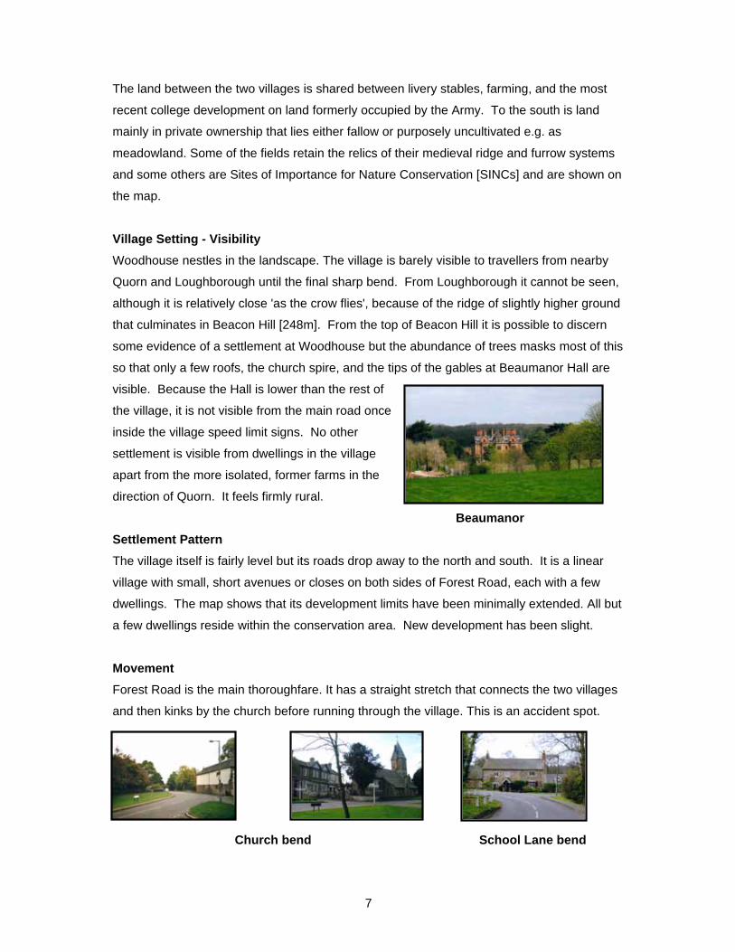
Village Setting - Visibility Woodhouse nestles in the landscape. The village is barely visible to travellers from nearby
Quorn and Loughborough until the final sharp bend. From Loughborough it cannot be seen,
although it is relatively close 'as the crow flies', because of the ridge of slightly higher ground
that culminates in Beacon Hill [248m]. From the top of Beacon Hill it is possible to discern
some evidence of a settlement at Woodhouse but the abundance of trees masks most of this
so that only a few roofs, the church spire, and the tips of the gables at Beaumanor Hall are
visible. Because the Hall is lower than the rest of
the village, it is not visible from the main road once
inside the village speed limit signs. No other
settlement is visible from dwellings in the village
apart from the more isolated, former farms in the
direction of Quorn. It feels firmly rural.
Beaumanor Settlement Pattern The village itself is fairly level but its roads drop away to the north and south. It is a linear
village with small, short avenues or closes on both sides of Forest Road, each with a few
dwellings. The map shows that its development limits have been minimally extended. All but
a few dwellings reside within the conservation area. New development has been slight. Movement Forest Road is the main thoroughfare. It has a straight stretch that connects the two villages
and then kinks by the church before running through the village. This is an accident spot.
Church bend School Lane bend

8
There is a relatively high volume of vehicle traffic, much of it travelling at excessive speeds
[see survey results on Page 19]. The road is also narrow, has been reduced from a B to a C
classification, and is prohibited to heavy goods vehicles over 7.5 tons. There is an exception
for vehicles belonging to local hauliers in Woodhouse Eaves. Moving along the village on
foot is possible for most of its length. The pavement is narrow and difficult for wheelchair
users to negotiate. Drivers entering Forest Road from Home Farm Close, Vicary Lane,
School Lane and Briscoe Lane report sight-line difficulties. The roads in both directions out
of the village have several significant bends that have a history of vehicle accidents, some
serious. Some villagers living closest to the bends report dangers when leaving their
properties.
Travel directly to the east of the village is possible only along rural tracks. Footpaths and
bridleways appear like veins on the landscape and are routes for many walkers. Tracks and
official bridleways are used for horse riding in common with much of the wider Parish area,
which has a particularly high
ratio of horses to households
[1:2]. A cycle track runs from
the back of Beaumanor to
Loughborough. To Mucklin Wood Footpath School Lane
to Woodhouse Eaves GUIDELINES Design should emerge from an understanding of the context of Woodhouse. Good practice
would be for potential developers or applicants to be aware of archaeological, ecological and
heritage interests within the village, and would be recommended to contact the Archaeology
and Heritage Wardens in the Parish.
There is an expectation that developers will follow the guidance in Charnwood's Leading in
Design Supplementary Planning Document, the Local Development Framework and
Planning Policy Guidelines relevant to rural areas.
In particular:
Trees There should be a strong presumption that trees that provide significant amenity value will
be retained to maintain the appearance and character of the village and to preserve the
existing diversity in wildlife. Trees are a dominant feature of the street scene, especially on

9
Forest Road, but also throughout the village. Where trees have to be removed an
appropriate quantity and selection of native trees should replace them. Where the trees that
have to be cut down are protected by Tree Preservation Orders, appropriate replacement
tree planting will be a requirement.
Historic legacy It is expected that all development should be sympathetic to archaeological, ecological and
heritage interests in the village. All parties should be aware of the presence of ancient ridge
and furrow fields, which are part of the village’s heritage. Some fields and hedges are
SINCs and are shown on the map.
Wildlife Every care must be taken to preserve the protected species and their habitats in accordance
with the Local Biodiversity Plan. The Charnwood Leading in Design SPD requires a Design
Statement for any development in a sensitive area such as a conservation village. The SPD
emphasises that good design arises from an understanding of context, which includes
consideration of existing trees and natural/ecological features.
Footpaths The network of footpaths and bridleways should be sensitively managed and added to where
possible, as residents and visitors regularly use these. School Lane to Woodhouse Eaves,
Vicary Lane, and Beaumanor Drive to Woodthorpe are valuable arteries.
Landscape Setting Open spaces of Special Character [OSSC] are distinctive features of the village setting and
these green areas should be protected. Examples are the agricultural and meadowland
between Woodhouse and Woodhouse Eaves, Quorn, Woodthorpe and Swithland.
Residents consider these to be the most important features of village surroundings and they
are of importance to the County as a whole.
New development should incorporate a soft-approach landscaping scheme that is in keeping
with the majority of existing development. Creeping urbanisation should be avoided to
preserve the rural character. For example, Forest Road exhibits a balance between
buildings and soft edge boundaries and planting.

10
Roads Bends at either end of Forest Road and on School Lane are accident spots. They are also
visual assets that define the extent of the village. Whilst their safety should be monitored and
improved, they should be retained as historic features of rural England.
New developments that increase the amount of traffic in the village should contribute to
sensitive road safety solutions that encourage drivers to respect the village environment.
Roadside verges, highway footpaths and hedgerows in open countryside should reflect the
character of their surroundings and be maintained in a way that retains or enhances local
wildlife as well as safety.
BUILDINGS AND BOUNDARIES The buildings and boundaries of the village are derived from and fit well into the local
environment as the majority are built from local materials, including those within the
churchyard. The distinctive geology of the area has had a major influence on the
appearance of the village, as described below. The map shows how the buildings are
positioned relative to each other and the overall housing density pattern.
The village is far from uniform – the softer, tree lined setting
of the houses of Forest Road, contrasts with the dominant
hard landscape of the church and Garats Hay. The newer
development of Beaumanor Gardens [on the back cover]
with its mainly low-rise well spaced buildings is distinct from
the houses built by the Ministry of Defence starting at
Briscoe Lane which, although more utilitarian, have a rural
setting with lots of trees and an attractive play area. School
Lane has a rustic atmosphere with many mature trees; a
small brook edging the road and houses of varying sizes and
styles including some of the most picturesque in the village.
School Lane M.O.D. homes Thatched

11
Building Materials and Boundaries The predominant building materials in Woodhouse are locally quarried granite for walling
and Swithland slate for walling and roofs. The slate is blue-grey, tinged with reddish-purple
from King’s Hill, near Hanging Stone Rock. The typical cottage has a diminishing course
Swithland slate roof. Some of the oldest cottages are thatched. The majority of buildings are
constructed of granite and slate rubble stone. A number of the oldest properties in the
village are rendered. Brick is largely used decoratively, and large expanses of brick are
untypical. Where brick is used it is soft-hued red and buff. These materials link present day
Woodhouse to its landscape and history.
Sorting roof slates Slate, stone & brick Rendered
The churchyard of St Mary in
the Elms is one example. The
fine collection of slate
gravestones still in situ gives a
sense of heritage.
Churchyard Herrick Family tomb
The Influence of Beaumanor on Design Elements of design of some buildings reflect the big house. There were many properties
built in the mid 19th century by the Beaumanor Estate. These reflect the ornate Victorian
Gothic style of Beaumanor Hall. Dwelling boundaries are a mixture of mainly hedging and
granite stone walls well below 2m in height. Iron railings are another local feature, recently
replaced at Golden Cottage, one of the oldest dwellings in the village. Stone walls have
either slate or brick caps. These photographs and drawings show typical design features.
Granite walls with brick posts and slate tops

12
Boundaries of wood hedging and iron railings
Beaumanor Lodge, the old almshouses and other period details based on Beaumanor
These distinctive, picturesque design features include roofed arched porches, deeply
overhanging eaves adding shadow and character, decorative chimneys, diminishing course
slate roofs, window styles e.g. Yorkshire sliding and double hung casements.
Roofed porches and a front gate Deep eaves and dormers
Decorative chimneys
Diminishing course roof Stone and brick mullions Diamond lights

13
The cottages and farms built for the Beaumanor estate workers are still dominant features of
the village today. Even some of these originally modest dwellings are listed or registered by
Charnwood Borough Council as Buildings of Local Historic/Architectural Value [see the list
on Page 18].
Home Farm - listed Estate workers' cottages
Renovation, Extensions and Conversions Most village development has been in-fill, extensions, conversions and renovation. School
Lane has many examples of this and by and large, these changes have not been over
intensive or detrimental and have used local materials.
School Lane cottages This lane is regarded by many as typifying the essential characteristics of the village. The
landscape is soft with mature trees and hedges. There is a mix of what were simple
cottages, farmhouses and grander buildings including the original school. There are a few
modern houses tucked between the older properties. Pest Cottage, with its timer frame,
thatched roof and traditional cottage garden is a much photographed village landmark. It
has been extended and converted from two cottages into one. The other cottages shown
above are also examples where extensions are in the same style as the original dwellings.
The conversion of farm buildings to residential
use started post war with the conversion of
Home Farm. One of a number of attractive
examples is seen in the photographs.

14
New development This has been relatively slow and, with a few recent exceptions,
has been sympathetic to village character. Beaumanor Gardens
is the only sizeable new residential development, built on the
former market garden of Beaumanor in 1970. The development
comprises low-density houses and bungalows of various
designs. With the soft landscaping, use of roofing slates,
granite facing and relatively low height; they do not obtrude on
the village skyline and fit well within an attractive rural setting.
That it is a no through road is also in keeping with village
settlement patterns - other examples are Home Farm Close and School Lane.
Judges in the Charnwood Design Awards Scheme
commended the newest house in the village at the corner of
Forest Road and Beaumanor Drive in 2004. The house
design and materials used are in sympathy with the
established traditional properties on Forest Road. Mature
trees surround the house, which blends into the landscape.
The Sixth Form College is the most recent and the largest development since the sixties.
The planning application was extensively researched to protect the landscape, archaeology,
trees and wildlife. Although modern, the buildings include local materials such as granite and
timber. The tree-planting scheme will enable the site to better complement the village
character in due course. As it is set in a hollow it is apparent only to travellers entering the
village from Woodhouse Eaves, and at night when lights are on.
GUIDELINES These guidelines refer to changes to existing buildings, boundaries and new developments.
They complement and reinforce Leading in Design. Planning applications should
demonstrate an appreciation of the village context and an appraisal of the site.
Buildings and boundaries The village character identified in the preceding text and illustrations should be recognised
and sympathetically applied in the design of new development or extensions to existing
buildings.

15
Particular attention should be paid to the following details:
• Materials and colour: The use of sympathetic natural/replica roofing slate [blue-grey and
tinged with purple]; granite and slate rubble stone as walling materials; timber; soft-hued
red and buff brick; thatch and render.
• Scale and house size: - Cottage-scale buildings e.g. semi-detached and detached
cottages.
• Density: - the overall pattern is of low density building, but some variation is acceptable
as there are spacious plots e.g. Beaumanor Gardens and irregular building patterns e.g.
Vicary Lane and School Lane.
• Height and roof level: - Typically one and half and two storey buildings below the height
of most mature trees.
• Silhouette: - Irregular and small scale e.g. different height roofs, porches of adjacent
houses at right angles - not all existing dwellings face onto the road.
Materials and design To be in keeping with the majority of village building and boundaries; the materials and
design features illustrated in this document should be used e.g. mellow coloured brick is
acceptable as trimming but large expanses of brick work are inappropriate.
Height Roof heights, chimneys, aerials and loft conversions should be in line with the majority of
properties and within the existing overall village skyline. This includes the erection of
communication masts or towers and tall chimneys. If a mast is considered to be essential it
should be erected well outside the village boundary and fully screened with natural native
planting.
Street patterns New developments and changes to existing buildings should respect existing street patterns,
land contours and building lines.
Space
The spacing of properties should maintain the overall characteristic of low-density building.
Plot shapes, sizes and building placement should reflect existing patterns and layouts e.g.
Beaumanor Gardens, Vicary Lane and Home Farm Close are 'no through roads' off Forest
Road.

16
Garages and car parking Garages should be unobtrusive and set back from the building line. Car parking areas
should be soft-landscaped and integrated, and allow for good visibility.
Historic legacy Developers should incorporate the best of historical features within the design of new
developments, for example, the influence of Beaumanor on chimney styles and porches.
Many of the older semi-detached homes have front doors at right angles to each other - a
legacy of the Herrick matriarch's views on neighbours talking instead of getting on with their
work.
Planning applications In accordance with Leading in Design plans for new developments should include an
appropriate drawing or artist's impression. This is to show the relationship of the proposed
development to surrounding buildings and countryside. It should help to demonstrate
whether the proposed development would be in keeping with the rest of the village.
For permitted developments, developers should consider the VDS advice before they make
a decision about how to proceed in this conservation area.

17
CONSULTATION This document began with the Woodhouse Parish Plan. A survey of all households in the
Parish during the summer of 2004 asked residents what they felt contributed most to the
Parish landscape - their sense of place. At the top of the list were open spaces, followed by
stone walls, trees, farmland and hedges. Residents were also asked about development:
what kind they felt was appropriate and the building materials they valued.
Households were also asked if they were interested in producing a design statement. From
those who said yes, a steering group was formed. They met regularly from spring to autumn
2005. One of the group is a parish councillor, another is the Borough and County Councillor.
The steering group organised two open meetings to gather residents' views on their village.
One of these included a walkabout. A flyer was delivered to every household in the village.
All residents were encouraged to submit pictures and drawings that they felt represented the
character of where they live.
Surveys of features including wildlife, archaeology and history were undertaken from local
documents and the Holly Hayes Resource Centre.
An exhibition of the photographs and drawings was mounted at the village garden party so
that residents could vote for the images that they felt were the most significant and
representative of what made their village special. The event also included paintings and
drawings produced by local schoolchildren who had worked to a similar brief. These can be
seen on the community website at http://www.woodhouse-eaves.co.uk/vds/
In addition, there has been publicity in local church and community magazines, the local
Loughborough Echo newspaper, and in regular reports to monthly Parish Council meetings,
which are open to members of the public.
A team then put the document together and invited comments from the Parish Council and
all households in the village. Advice was obtained from the Leicestershire and Rutland
Rural Community Council, from neighbouring villages that had already produced their design
statements, and from Charnwood Borough Council. The Parish Wardens for Archaeology,
Heritage and Trees were also consulted. Comments were requested from the Countryside
Agency, English Heritage, English Nature and the Environment Agency.

18
LISTED BUILDINGS IN WOODHOUSE Grade I Buildings of exceptional interest, representing about 2% of all listed buildings. Grade II* Particularly important buildings of more than special interest representing about 4% of
listed buildings. Grade II Buildings of special interest, which warrant every effort being made to preserve them.
Listing covers all parts of the property and its curtilage, i.e. all internal and external elements whether described or not.
Descriptive details are at www.charnwood.gov.uk/environment/woodhouse.html Conservation and Design Team [email protected] Telephone (01509) 634767 & 634748
GRADE Beaumanor Hall Beaumanor Park II* Beaumanor Hall, stables, clock tower and outhouses Beaumanor Park II* Beaumanor Hall, terrace walls, urns, fountains, seats Beaumanor Park II* Beaumanor Hall, bridge before stables Beaumanor Park II Beaumanor Hall, fountain in stable yard Beaumanor Park II Beaumanor Hall Lodge Forest Road (west side) II Beaumanor Hall Lodge, gates, piers & walls Forest Road (west side) II Kennels Cottage (now Beaumanor House) Beaumanor Park II St Mary's Churchyard, Herrick family tomb, Forest Road (east side) II St Mary in the Elms Church Forest Road (east side) II St Mary's Churchyard, Heanes family headstones Forest Road (east side) II St Mary's Churchyard, War Memorial in wall Forest Road (east side) II Garat’s Hay Forest Road (east side) II Village well house Forest Road (east side) II Village telephone kiosk K6 Forest Road (west side) II 230 (Home Farm) Forest Road (east side) II 240 Forest Road (east side) II 242 (Pear Tree Cottage) Forest Road (east side) II 244 Forest Road (east side) II 258 (Thatched Cottage) Forest Road (east side) II 264 Forest Road (east side) II 274 (Little Thatch) Forest Road (east side) II 280 (Golden Cottage) Forest Road (east side) II 209 (Almshouse) Forest Road (west side) II 211 (Almshouse) Forest Road (west side) II 213 (Almshouse) Forest Road (west side) II 215 (Almshouse) Forest Road (west side) II 227 (The Holt) Forest Road (west side) II 229 Forest Road (west side) II 241 Forest Road (west side) II 243 Forest Road (west side) II 271 (Bishops Cottage) Forest Road (west side) II 273 Forest Road (west side) II Rushall Field Farm Rushey Lane (south side) II 26 & 28 (Pest Cottage) School Lane (north side) II 31 (Valley Cottage) School Lane (south side) II 41 (Brook Cottage) School Lane (south side) II 43 Barn School Lane (south side) II 45 (Lane End Cottage) School Lane (south side) II Foxhills & Nursery Cottage Vicary Lane (east side) II

19
EXTRACTS FROM THE WOODHOUSE PARISH PLAN SURVEY Most important problems in the parish environment [Tick 3]
No. % Traffic 349 68.4
Litter 203 39.8Dog mess 177 34.7
Aircraft noise 100 19.6Other 64 12.6
Fly-tipping 48 9.4None 42 8.2
Street lighting 28 5.5Graffiti 27 5.3
Number of households 510 Features contributing most to the landscape [Tick 3]
No. % Open spaces around the two villages 425 83.7
Dry stone walls 271 53.4 Individual & groups of trees 250 49.2
Farmland 242 47.6 Hedgerows 184 36.2
Other 14 2.8 None 3 0.6
Number of households 508 Most serious traffic problems [Tick 3]
No. % Speed 339 69.8
Parking 233 47.9Volume 94 19.3
Number of light/heavy goods vehicles 59 12.1Noise 55 11.3
Congestion 42 8.6None 48 9.9
Number of respondents 486 New housing blending in [e.g. local stone / slate] [Tick one]
No. % Very important 383 76.8
Fairly important 91 18.2Not very important 18 3.6
Don't know 7 1.4Number of households 499 100.0
Most liked about living here [443 free text responses]
1. Countryside, surroundings, views, scenery, setting, situation, landscape, nature, wildlife, trees, walks, bridleways (261)
2. Inhabitants, residents, people, neighbours, friendly, community, helpful, welcoming, sense of belonging, supportive, caring (174)
3. Tranquil, quiet, peace, unspoilt, peaceful, serene, relaxed, lack of stress, no hustle & bustle, no rat-race (110)
4. Convenience/access to towns, cities, motorways, airports, trains, buses, public transport (66) 5. Environment, healthy, clean, air, quality of life (40) 6. Village, small, size, no new housing estates (16)

ACKNOWLEDGMENTS
Thanks to:
All the residents of Woodhouse - for photographs, comments, time, and the care they give to
their lovely properties.
Woodhouse Village Design Statement Steering Group - for the enormous amount of effort
and time needed to do the work and put it all together.
Martin Tincknell, Conservation & Design Manager, Charnwood Borough Council - for
valuable and patient guidance on content.
Hazel Fish, Rural Community Council - for enthusiastic support to get it started.
The editors of Roundabout and The Woodhouses Parish Magazine for valuable publicity.
Staff at the Holly Hayes Environmental Resource Centre [Leicestershire Museums Service]
for help in identifying SINCs.
And a special thanks to David Langton [1930 - 2005] who helped to "keep it visual" and
designed the cover.
Steering Group: David Slater
Jill Baguley
Jane Woodland
Pauline Knowles
Dennis Nuttall
Marsha Blissett
Hilary Fairbairn
Ann Irving
20

Woodhouse from the air
© Getmapping.com

Developing the legacy in the future