conceptual model of providing traffic navigation …
TRANSCRIPT

Promet – Traffic&Transportation, Vol. 26, 2014, No. 3, 209-218 209
M. Periša, D. Peraković, S. Šarić: Conceptual Model of Providing Traffic Navigation Services to Visually Impaired Persons
MARKO PERIŠA, Ph.D. E-mail: [email protected] Prof. DRAGAN PERAKOVIĆ, Ph.D. E-mail: [email protected] Prof. SLAVKO ŠARIĆ, Ph.D. E-mail: [email protected] Faculty of Transport and Traffic Sciences, University of Zagreb Vukelićeva 4, HR-10000 Zagreb, Croatia
Information and Communication Technology Preliminary Communication
Submitted: Mar. 14, 2014 Approved: May 21, 2014
CONCEPTUAL MODEL OF PROVIDING TRAFFIC NAVIGATION SERVICES TO VISUALLY IMPAIRED PERSONS
ABSTRACT
In order to include people of reduced mobility in the traf-fic system it is necessary to provide accessibility and infor-mation of the users to all the facilities surrounding them. By analysing the currently available information and com-munication technologies a new conceptual model of provid-ing navigation services to the visually impaired persons has been proposed. This model is based on Cloud Computing platform, and this research describes the method of navi-gating the users based on accurate and updated data. The users’ requirements have been analysed according to the needs of the movement of visually impaired persons along the traffic network. The information and communication so-lutions with the function of informing these groups of users have to provide accurate and updated data, which is made possible by the proposed model. This research was con-ducted on the most frequent routes in the city of Zagreb. With the review of model efficiency user’s sense of security is increased in the amount of 87%.
KEY WORDS
Cloud Computing; real-time information; assistive technol-ogy; traffic network; mobility
1. INTRODUCTION
Persons with reduced mobility can be divided into several categories which depend on the level of their impairment. The main classification of these persons is into the persons with impaired vision, speech and hearing. In this research the defined group of users are persons with impaired vision (partially sighted and blind persons). According to the latest available data there are 1,985 visually impaired persons in the City of Zagreb [1]. Out of this figure, 171 users are perma-nently employed, and this figure is defined as a rele-
vant sample in carrying out this study (the mentioned persons move daily along the traffic network).
The visually impaired persons (further in the text “users”) in their independent movement along the traffic network use the basic aids, white cane or guide dog. By using one of the aids the user obtains infor-mation within a radius of up to 1.50 [m]. The draw-back of such a form of information is other information which includes: better perception of the surround-ings, orientation, possibility of faster decision-making, and better mobility. The mentioned information can be substituted by the application of information and communication (IC) technologies and services, which defines the concept of assistive technologies in traffic [2]. One of the applications of assistive technologies is reflected in the use of IC solutions for the guidance and navigation of the users along the traffic network. The mentioned solutions are based on global naviga-tion satellite systems (GNSS), systems for data trans-fer in mobile networks (GPRS, EDGE, UMTS, etc.) and geographic information systems (GIS) [3]. The user in-terface is an important component in such solutions because it has to be adapted and fully available by its functions. By analysing the availability of GPS systems the main problem in such solutions are errors in infor-mation about the user’s location [4]. The mentioned drawbacks can be substituted by the application of other technologies in the function of locating and navi-gating the users, as well as informing purposes [5]. The identification of traffic intersections as parts of the traffic network is possible by the application of points of interest (POI) within mobile applications [6, 7]. POI markings have the role of informing the users about a certain facility, which is in their vicinity.
Information on the user’s location and environ-ment represents the basic parameter in defining the
M. Periša, D. Peraković, S. Šarić: Conceptual Model of Providing Traffic Navigation Services to Visually Impaired Persons
210 Promet – Traffic&Transportation, Vol. 26, 2014, No. 3, 209-218
user’s request for route planning. The collection of all relevant data into one information system is possible by applying the proposed conceptual model based on Cloud Computing (CC) platform. CC is used as a plat-form in case of services for identification of traffic in-tersections, but also in case of identifying pedestrian crossings [8, 9, 10].
2. METHODOLOGY OF RESEARCH
The problem of research is indicated through the absence of accurate and updated information that sur-round the user while moving along the traffic network. The research included 101 users who move indepen-dently and daily in the area of the city of Zagreb, which is 59% of the predicted number (171). Apart from this, also the users who use guide dogs – 14 (100%) and student population – 29 (100%) participated in the study as well. The users participated in the survey in-dependently by means of on-line questionnaire, and per telephone in the form of interview.
As part of this research, one of the authors at-tended the training of orientation and movement with an authorized peripathologist in the duration of six months, satisfying all the training methods. The re-sults of the training are reflected in the definition of the picture (perception) of the surrounding, feeling of safety, orientation, identification of elements of the traffic intersection and determining of the method of traffic control at a traffic intersection.
When calculating the duration of the green phase for the pedestrians in the Republic of Croatia the aver-age speed of the users of .v 1 2r = [m/s] to maximum 1.5 [m/s] is taken (in places with extreme traffic a low-er value is taken as well) [11]. For persons of reduced mobility this speed should not be lower than 1.0 [m/s], whereas the research results show that the mean us-ers’ speed is 0.55 [m/s].
In evaluating the accessibility of mobile terminal devices and availability of certain services the re-search [12] has been used. The research shows that
143 users use mobile terminal devices, which is im-portant when designing this conceptual solution.
3. CURRENT STATE
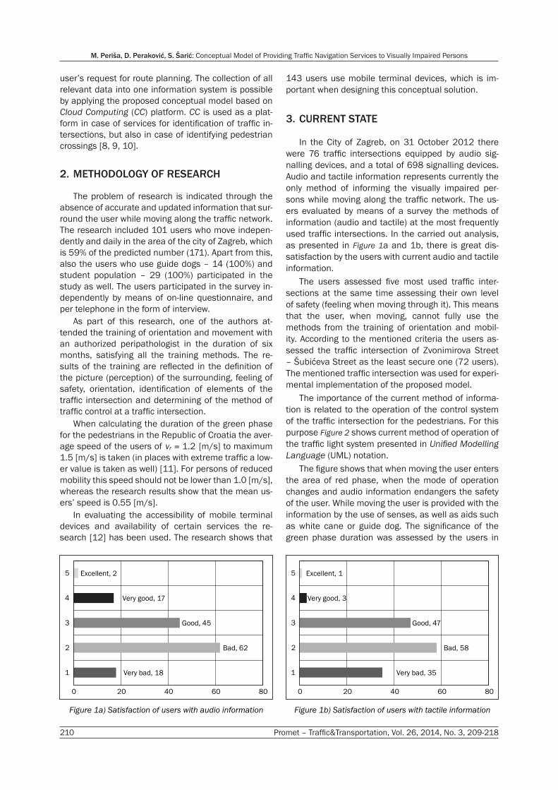
In the City of Zagreb, on 31 October 2012 there were 76 traffic intersections equipped by audio sig-nalling devices, and a total of 698 signalling devices. Audio and tactile information represents currently the only method of informing the visually impaired per-sons while moving along the traffic network. The us-ers evaluated by means of a survey the methods of information (audio and tactile) at the most frequently used traffic intersections. In the carried out analysis, as presented in Figure 1a and 1b, there is great dis-satisfaction by the users with current audio and tactile information.
The users assessed five most used traffic inter-sections at the same time assessing their own level of safety (feeling when moving through it). This means that the user, when moving, cannot fully use the methods from the training of orientation and mobil-ity. According to the mentioned criteria the users as-sessed the traffic intersection of Zvonimirova Street – Šubićeva Street as the least secure one (72 users). The mentioned traffic intersection was used for experi-mental implementation of the proposed model.
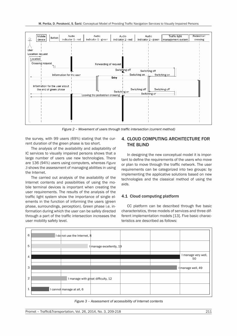
The importance of the current method of informa-tion is related to the operation of the control system of the traffic intersection for the pedestrians. For this purpose Figure 2 shows current method of operation of the traffic light system presented in Unified Modelling Language (UML) notation.
The figure shows that when moving the user enters the area of red phase, when the mode of operation changes and audio information endangers the safety of the user. While moving the user is provided with the information by the use of senses, as well as aids such as white cane or guide dog. The significance of the green phase duration was assessed by the users in
Very bad, 18
Bad, 62
Good, 45
Very good, 17
Excellent, 2
0 20 40 60 80
1
2
3
4
5
Figure 1a) Satisfaction of users with audio information
Very bad, 35
Bad, 58
Good, 47
Very good, 3
Excellent, 1
0 20 40 60 80
1
2
3
4
5
Figure 1b) Satisfaction of users with tactile information
Promet – Traffic&Transportation, Vol. 26, 2014, No. 3, 209-218 211
M. Periša, D. Peraković, S. Šarić: Conceptual Model of Providing Traffic Navigation Services to Visually Impaired Persons
the survey, with 99 users (69%) stating that the cur-rent duration of the green phase is too short.
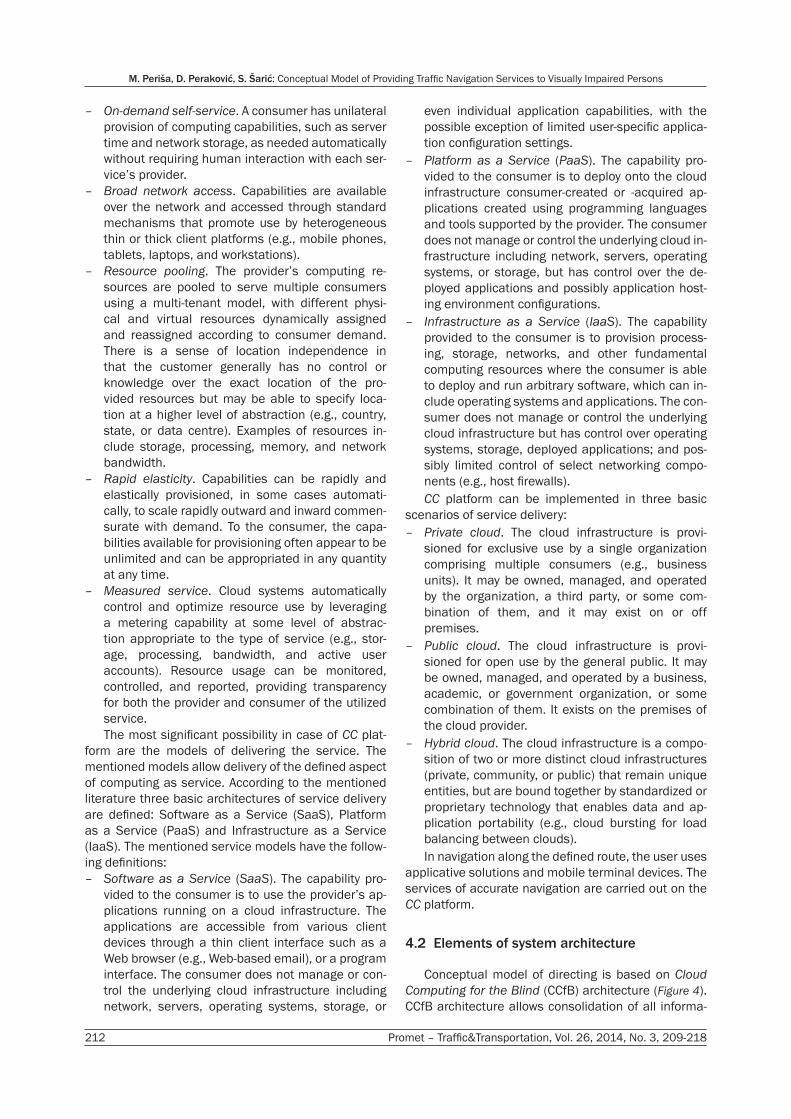
The analysis of the availability and adaptability of IC services to visually impaired persons shows that a large number of users use new technologies. There are 136 (94%) users using computers, whereas Figure 3 shows the assessment of managing abilities in using the Internet.
The carried out analysis of the availability of the Internet contents and possibilities of using the mo-bile terminal devices is important when creating the user requirements. The results of the analysis of the traffic light system show the importance of single el-ements in the function of informing the users (green phase, surroundings, perception). Green phase i.e. in-formation during which the user can be safely directed through a part of the traffic intersection increases the user mobility safety level.
4. CLOUD COMPUTING ARCHITECTURE FOR THE BLIND
In designing the new conceptual model it is impor-tant to define the requirements of the users who move or plan to move through the traffic network. The user requirements can be categorized into two groups: by implementing the applicative solutions based on new technologies and the classical method of using the aids.
4.1 Cloud computing platform
CC platform can be described through five basic characteristics, three models of services and three dif-ferent implementation models [13]. Five basic charac-teristics are described as follows:
I cannot manage at all, 6
I manage with great difficulty, 12
I manage well, 49
I manage very well,
50
I manage excellently, 19
I do not use the Internet, 8
1
2
3
4
5
6
Figure 3 – Assessment of accessibility of Internet contents
Figure 2 – Movement of users through traffic intersection (current method)
M. Periša, D. Peraković, S. Šarić: Conceptual Model of Providing Traffic Navigation Services to Visually Impaired Persons
212 Promet – Traffic&Transportation, Vol. 26, 2014, No. 3, 209-218
– On-demand self-service. A consumer has unilateral provision of computing capabilities, such as server time and network storage, as needed automatically without requiring human interaction with each ser-vice’s provider.
– Broad network access. Capabilities are available over the network and accessed through standard mechanisms that promote use by heterogeneous thin or thick client platforms (e.g., mobile phones, tablets, laptops, and workstations).
– Resource pooling. The provider’s computing re-sources are pooled to serve multiple consumers using a multi-tenant model, with different physi-cal and virtual resources dynamically assigned and reassigned according to consumer demand. There is a sense of location independence in that the customer generally has no control or knowledge over the exact location of the pro-vided resources but may be able to specify loca-tion at a higher level of abstraction (e.g., country, state, or data centre). Examples of resources in-clude storage, processing, memory, and network bandwidth.
– Rapid elasticity. Capabilities can be rapidly and elastically provisioned, in some cases automati-cally, to scale rapidly outward and inward commen-surate with demand. To the consumer, the capa-bilities available for provisioning often appear to be unlimited and can be appropriated in any quantity at any time.
– Measured service. Cloud systems automatically control and optimize resource use by leveraging a metering capability at some level of abstrac-tion appropriate to the type of service (e.g., stor-age, processing, bandwidth, and active user accounts). Resource usage can be monitored, controlled, and reported, providing transparency for both the provider and consumer of the utilized service.The most significant possibility in case of CC plat-
form are the models of delivering the service. The mentioned models allow delivery of the defined aspect of computing as service. According to the mentioned literature three basic architectures of service delivery are defined: Software as a Service (SaaS), Platform as a Service (PaaS) and Infrastructure as a Service (IaaS). The mentioned service models have the follow-ing definitions:
– Software as a Service (SaaS). The capability pro-vided to the consumer is to use the provider’s ap-plications running on a cloud infrastructure. The applications are accessible from various client devices through a thin client interface such as a Web browser (e.g., Web-based email), or a program interface. The consumer does not manage or con-trol the underlying cloud infrastructure including network, servers, operating systems, storage, or
even individual application capabilities, with the possible exception of limited user-specific applica-tion configuration settings.
– Platform as a Service (PaaS). The capability pro-vided to the consumer is to deploy onto the cloud infrastructure consumer-created or -acquired ap-plications created using programming languages and tools supported by the provider. The consumer does not manage or control the underlying cloud in-frastructure including network, servers, operating systems, or storage, but has control over the de-ployed applications and possibly application host-ing environment configurations.
– Infrastructure as a Service (IaaS). The capability provided to the consumer is to provision process-ing, storage, networks, and other fundamental computing resources where the consumer is able to deploy and run arbitrary software, which can in-clude operating systems and applications. The con-sumer does not manage or control the underlying cloud infrastructure but has control over operating systems, storage, deployed applications; and pos-sibly limited control of select networking compo-nents (e.g., host firewalls).CC platform can be implemented in three basic
scenarios of service delivery: – Private cloud. The cloud infrastructure is provi-
sioned for exclusive use by a single organization comprising multiple consumers (e.g., business units). It may be owned, managed, and operated by the organization, a third party, or some com-bination of them, and it may exist on or off premises.
– Public cloud. The cloud infrastructure is provi-sioned for open use by the general public. It may be owned, managed, and operated by a business, academic, or government organization, or some combination of them. It exists on the premises of the cloud provider.
– Hybrid cloud. The cloud infrastructure is a compo-sition of two or more distinct cloud infrastructures (private, community, or public) that remain unique entities, but are bound together by standardized or proprietary technology that enables data and ap-plication portability (e.g., cloud bursting for load balancing between clouds).In navigation along the defined route, the user uses
applicative solutions and mobile terminal devices. The services of accurate navigation are carried out on the CC platform.
4.2 Elements of system architecture
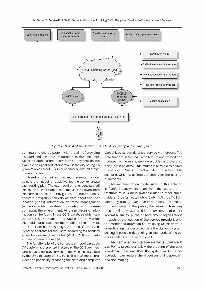
Conceptual model of directing is based on Cloud Computing for the Blind (CCfB) architecture (Figure 4). CCfB architecture allows consolidation of all informa-
Promet – Traffic&Transportation, Vol. 26, 2014, No. 3, 209-218 213
M. Periša, D. Peraković, S. Šarić: Conceptual Model of Providing Traffic Navigation Services to Visually Impaired Persons
tion into one shared system with the aim of providing updated and accurate information to the end user. Specified architecture illustrates CCfB system on the example of signalized intersection in the city of Zagreb (Zvonimirova Street – Šubićeva Street), with all stake-holders involved.
Based on the defined user requirements the user selects the model of assistive technology to create their routing plan. The user requirements consist of all the relevant information that the user receives from the service of accurate navigation. The information of accurate navigation consists of: data about the user location (maps), information on traffic management (audio or tactile), real-time information and informa-tion about the environment. All these pieces of infor-mation can be found in the CCfB database which can be assessed by means of the Web portal or by using the mobile application on the mobile terminal device. It is important here to satisfy the criteria of accessibil-ity of the contents for the users, according to Standard guide for designing web sites (WCAG 2.0) standards and recommendations [14].
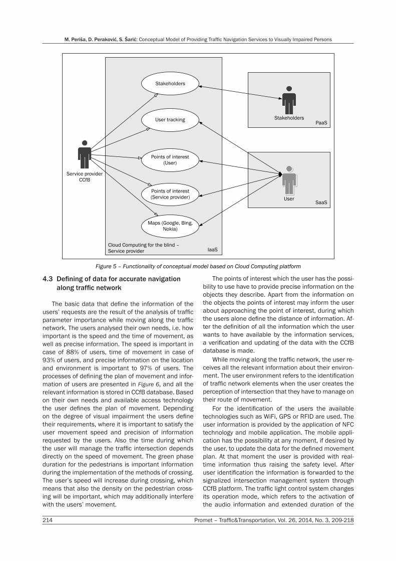
The functionality of the conceptual model based on CC platform is presented in Figure 5. The CCfB architec-ture is based on IaaS service model which is described by the UML diagram of Use case. The IaaS model pro-vides the possibility of storing the data and computer
capabilities as standardized service via network. The data that are in the IaaS architecture are created and updated by the users, service provider and the third party (stakeholders). This makes it possible to deliver the service in SaaS or PaaS architecture in the public scenario, which is defined depending on the user re-quirements.
The implementation model used in this solution is Public Cloud, where apart from the users the in-frastructure in CCfB is available also to other stake-holders (Croatian Automobile Club - HAK, traffic light control system…). Public Cloud represents the model of open usage by the public; the infrastructure may be controlled by, used and in the ownership of one or several business, public or government organizations (it exists at the location of the service provider). With the mentioned approach i.e. by using CC platform in consolidating the described data the dynamic system scaling is possible depending on the needs of the us-ers as well as of the system itself.
The mentioned architecture elements (User track-ing, Points of interest) allow the creation of the user knowledge base and thus the system in its further operation can feature the processes of independent decision-making.
Cloud Computing for the Blind
WEB portalMOBILE
terminal
device
Automatic traffic
control systemCroatian automobile
clubPublic traffic system controlOther stakeholders
User requirements for defined route planning
User
Navigation maps
Traffic intersection information
Refined location information
Real-time traffic information
Mobile application
Figure 4 - Simplified architecture of the Cloud Computing for the Blind system
M. Periša, D. Peraković, S. Šarić: Conceptual Model of Providing Traffic Navigation Services to Visually Impaired Persons
214 Promet – Traffic&Transportation, Vol. 26, 2014, No. 3, 209-218
4.3 Defining of data for accurate navigation along traffic network
The basic data that define the information of the users’ requests are the result of the analysis of traffic parameter importance while moving along the traffic network. The users analysed their own needs, i.e. how important is the speed and the time of movement, as well as precise information. The speed is important in case of 88% of users, time of movement in case of 93% of users, and precise information on the location and environment is important to 97% of users. The processes of defining the plan of movement and infor-mation of users are presented in Figure 6, and all the relevant information is stored in CCfB database. Based on their own needs and available access technology the user defines the plan of movement. Depending on the degree of visual impairment the users define their requirements, where it is important to satisfy the user movement speed and precision of information requested by the users. Also the time during which the user will manage the traffic intersection depends directly on the speed of movement. The green phase duration for the pedestrians is important information during the implementation of the methods of crossing. The user’s speed will increase during crossing, which means that also the density on the pedestrian cross-ing will be important, which may additionally interfere with the users’ movement.
The points of interest which the user has the possi-bility to use have to provide precise information on the objects they describe. Apart from the information on the objects the points of interest may inform the user about approaching the point of interest, during which the users alone define the distance of information. Af-ter the definition of all the information which the user wants to have available by the information services, a verification and updating of the data with the CCfB database is made.
While moving along the traffic network, the user re-ceives all the relevant information about their environ-ment. The user environment refers to the identification of traffic network elements when the user creates the perception of intersection that they have to manage on their route of movement.
For the identification of the users the available technologies such as WiFi, GPS or RFID are used. The user information is provided by the application of NFC technology and mobile application. The mobile appli-cation has the possibility at any moment, if desired by the user, to update the data for the defined movement plan. At that moment the user is provided with real-time information thus raising the safety level. After user identification the information is forwarded to the signalized intersection management system through CCfB platform. The traffic light control system changes its operation mode, which refers to the activation of the audio information and extended duration of the
Service provider
CCfB
Maps (Google, Bing,
Nokia)
Points of interest
(Service provider)
Points of interest
(User)
User tracking
Stakeholders
User
Stakeholders
Cloud Computing for the blind –
Service provider IaaS
PaaS
SaaS
Figure 5 – Functionality of conceptual model based on Cloud Computing platform

Promet – Traffic&Transportation, Vol. 26, 2014, No. 3, 209-218 215
M. Periša, D. Peraković, S. Šarić: Conceptual Model of Providing Traffic Navigation Services to Visually Impaired Persons
green phase. The duration of the green phase (mini-mum length) is calculated according to the following formula:
t vs
zkr= [s]
where: tz – green phase duration [s];
sr – total length of traffic lanes which is neces-sary for managing the crossing [m], and
vk – average movement speed – 0.55 [m/s].In the mentioned calculation the average speed
obtained from the performed measurements at the analysed intersection is used. Users, which were using mobile guidance and navigation application, were in-volved, with starting and end points defined as points of interests (POI).
At the moment of identification the user receives all the information: about the location, objects that sur-round them, position of the descending and ascend-ing curb, traffic control mode (tactile line, traffic light system or something else), time of the right moment to cross the street, time of arrival to the destination, and information on the system operation (failure of the system or upgrading). The user routing after identifica-tion towards the initial point of crossing is provided in a safe and coordinated way.
At the moment of waiting to cross the traffic lane, the user receives all information about the size of the traffic intersection (how many lanes and in which di-rection), street names (defined according to the geo-graphical direction), existence of landmarks, tactile elements of accessibility, tramway lines, and possible directions of movement. If the pedestrian crossing is at
Defining of assistive
technology for trip
selection?
Technology
defined
No
Yes
Web portal app. Mobile application
User registration
process
Selection of
impairment level
Defining of movement
plan?
Movement plan
defined
No
Yes
Request for creating
movement plan
Input of points of
interest
Defining of movement
plan?
No
Movement plan
defined
Updating with
database (CCfB)
Yes
Updating with mobile
application
Updating with
database (CCfB)
Information on user’s
environment
User identification
Change in traffic light
system operationInforming the user on
movement zone
Longer green phase
for pedestrians
Information on
environment
Information on
movement plan
Navigation to initial
point of crossing
Movement of user
through traffic
intersection
Arrival to destination
point within the traffic
intersection
Further navigation
according to
movement plan
Informing the user
Informing the user
Updating with
database (CCfB)
Figure 6 – Methods of informing the users about the traffic intersection
M. Periša, D. Peraković, S. Šarić: Conceptual Model of Providing Traffic Navigation Services to Visually Impaired Persons
216 Promet – Traffic&Transportation, Vol. 26, 2014, No. 3, 209-218
an angle (example of the intersection of the analysed intersection), the user also receives this information and aligns the body to the respective position. For ex-ample: Direction of movement North–South, Šubićeva Street, position of body at 30° to the right. After confir-mation of the audio information for crossing the traffic intersection, the user arrives to the destination point. Upon arrival the user gets the information that they have arrived to the destination, and the information about the possibility of further moving by using the movement directions according to the geographical directions.
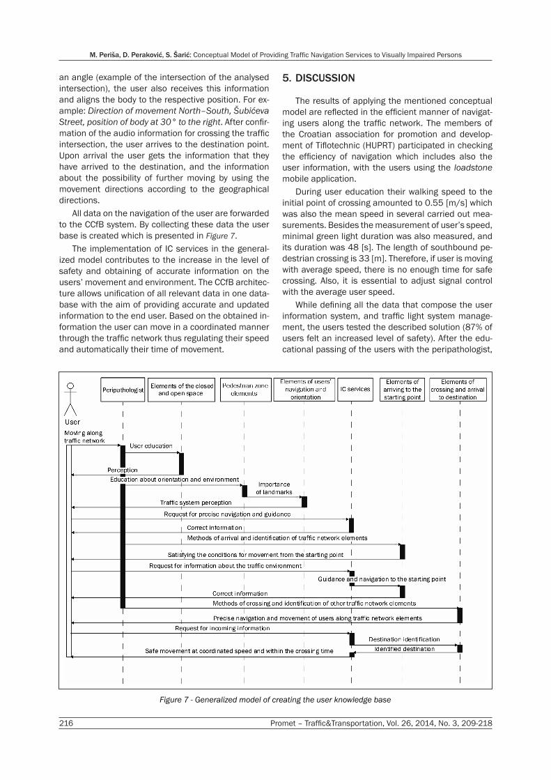
All data on the navigation of the user are forwarded to the CCfB system. By collecting these data the user base is created which is presented in Figure 7.
The implementation of IC services in the general-ized model contributes to the increase in the level of safety and obtaining of accurate information on the users’ movement and environment. The CCfB architec-ture allows unification of all relevant data in one data-base with the aim of providing accurate and updated information to the end user. Based on the obtained in-formation the user can move in a coordinated manner through the traffic network thus regulating their speed and automatically their time of movement.
5. DISCUSSION
The results of applying the mentioned conceptual model are reflected in the efficient manner of navigat-ing users along the traffic network. The members of the Croatian association for promotion and develop-ment of Tiflotechnic (HUPRT) participated in checking the efficiency of navigation which includes also the user information, with the users using the loadstone mobile application.
During user education their walking speed to the initial point of crossing amounted to 0.55 [m/s] which was also the mean speed in several carried out mea-surements. Besides the measurement of user’s speed, minimal green light duration was also measured, and its duration was 48 [s]. The length of southbound pe-destrian crossing is 33 [m]. Therefore, if user is moving with average speed, there is no enough time for safe crossing. Also, it is essential to adjust signal control with the average user speed.
While defining all the data that compose the user information system, and traffic light system manage-ment, the users tested the described solution (87% of users felt an increased level of safety). After the edu-cational passing of the users with the peripathologist,
Figure 7 - Generalized model of creating the user knowledge base

Promet – Traffic&Transportation, Vol. 26, 2014, No. 3, 209-218 217
M. Periša, D. Peraković, S. Šarić: Conceptual Model of Providing Traffic Navigation Services to Visually Impaired Persons
the user passed independently the entire movement route with the walking speed amounting to 0.66 [m/s], which is according to the carried out analysis in record-ing the initial state higher by 0.16 [m/s]. By exact infor-mation about the location and further navigation the user is provided with better perception of the environ-ment thus achieving greater independence and better coordination during movement.
As the architecture proposed for processing and lo-cation of data CC makes it possible for the described system to learn from the collected data which are available at any moment both to the applications and to the very system and the users. The advantages are also indicated in the availability of data at any moment independent of location.
There are no costs related to the purchase of hard-ware, licenses for server operating systems, databas-es, e-mail servers, their installation and configuration, and subsequent maintenance. All this is in the hands of service providers, rather than system users. The system user, as well as the third party, contribute by models SaaS and PaaS to the accuracy and updated-ness of the data which define information for the end users.
6. CONCLUSION
By analyzing the current condition of availability of the IC services to persons of reduced mobility in the traffic environment the base for new solutions has been set. The proposed conceptual model of providing the service of navigation on a defined case gives the user accurate and updated information. The visually impaired persons who create their movement plan by means of the web interface have to obtain real-time information via mobile terminal device and mobile ap-plication. This method of information raises the user’s level of safety during movement.
The CCfB architecture represents the method of collecting, processing and storing data that are always updated and available 24(hours)/7(days), with all the participants taking part in the creation, updating and checking of data. IC technologies available today to a greater extent are adapted to the users’ requirements, which does not limit the described solution, for other participants in the presented architecture as well.
This conceptual model facilitates improved control of managing the traffic intersection, precise navigation and better perception and orientation of the users. More efficient use of the currently available technol-ogy and its functionality makes it possible for the users of reduced mobility an improved level of the quality of living.
ACKNOWLEDGMENT
This research has been carried out as part of the project “Information and Communication Services for the Movement of Persons with Reduced Mobility along the Traffic Network”. The project is registered un-der number 5415 and funded as part of the program “Short-term Financial Support of Research”, University of Zagreb, 2013.
Dr. sc. MARKO PERIŠA E-mail: [email protected] Prof. dr. sc. DRAGAN PERAKOVIĆ E-mail: [email protected] Prof. dr. sc. SLAVKO ŠARIĆ E-mail: [email protected] Fakultet prometnih znanosti, Sveučilište u Zagrebu Vukelićeva 4, 10000 Zagreb, Hrvatska
SAŽETAK KONCEPTUALNI MODEL PRUŽANJA USLUGE PROMETNOG USMJERAVANJA OSOBA OŠTEĆENOG VIDA
Za uključivanje osoba smanjene i otežane pokretljivo-sti u prometni sustav potrebno je osigurati pristupačnost i informiranost korisnika svim sadržajima koji okružuju samu osobu. Analizom trenutno dostupne informacijsko-komunikacijske tehnologije predložen je novi konceptualni model pružanja usluge usmjeravanja osoba oštećenog vida. Navedeni model temelji se na Cloud Computing platformi, te je u ovom istraživanju opisan način usmjeravanja ko-risnika, na temelju točnih i ažurnih podataka. Korisnički zahtjevi analizirani su prema potrebama kretanja osoba oštećenog vida prometnom mrežom. Informacijsko-komu-nikacija rješenja u funkciji informiranja navedene skupine korisnika moraju omogućiti točne i ažurne podatke, što se i omogućava predloženim modelom. Istraživanje je prove-deno na najčešće korištenim rutama kretanja na području grada Zagreba. Provjerom učinkovitosti modela kod korisni-ka je zabilježen porast osjećaja sigurnosti u iznosu od 87%.
KLJUČNE RIJEČI
računalstvo u oblaku; stvarno-vremenske informacije; pomoćne tehnologije; prometna mreža; mobilnost
REFERENCES
[1] Report on Disabled Persons in the Republic of Croa-tia. Croatian National Institute for Public Health. Public Health Service; 2013.
[2] Brassai ST, Bako L, Losonczi L. Assistive Technolo-gies for Visually Impaired People. Acta Universitatis Sapientiae: Electrical and Mechanical Engineering. 2011;3:39-50.
[3] Kammoun S, Macé J-MM, Oriola B, Jouffrais C. De-signing a Virtual Environment Framework for Improv-ing Guidance for the Visually Impaired. In: Langdon P, Clarkson J, Robinson P, Lazar J, Heylighen A, editors. Designing Inclusive Systems: Designing Inclusion for

M. Periša, D. Peraković, S. Šarić: Conceptual Model of Providing Traffic Navigation Services to Visually Impaired Persons
218 Promet – Traffic&Transportation, Vol. 26, 2014, No. 3, 209-218
Real-world Applications. London: Springer; 2012. p. 217-226.
[4] May M, Casey K. Accessible Global Positioning Sys-tems. In: Manduchi R, Kurniawan S, editors. Assistive technology for Blindness and low vision. CRC Press, Taylor & Francis Group; 2013.
[5] Liao C, Choe P, Wu T, Tong Y, Dai C, Liu Y. RFID-Based Road Guiding Cane System for the Visually Im-paired, Cross-Cultural Design. Methods, Practice and Case Studies, Lecture Notes in Computer Science. 2013;8023:86-93.
[6] DeRuwe G, Wall R. Pedestrian Navigation and Inte-gration with Distributed Smart Signal Traffic Controls. IECON 2008, 34th Annual Conference of IEEE Indus-trial Electronics; 2008.
[7] McLeod FN, Hounsell NB, Rajbhandari B. Improving traffic signal control for pedestrians. RTIC 2004, 12th IEE International Conference on Road Transport Infor-mation and Control; 2004.
[8] Pelin A, Bhargava B, Helal S. A mobile-Cloud Collabo-rative Traffic lights Detector for Blind Navigation, IEEE 2010, Eleventh International Conference on Mobile Data Management (MDM); 2010.
[9] Yuriyama M, Kushida T. Sensor-Cloud Infrastructure - Physical Sensor Management with Virtualized Sensors
on Cloud Computing, 13th International Conference on Network-Based Information Systems (NBiS); 2010.
[10] Ahmetovic D, Bernareggi C, Mascetti S. Zebralocalizer: identification and localization of pedestrian crossings. In: Proceedings of the 13th International Conference on Human Computer Interaction with Mobile Devices and Services (MobileHCI ‘11). New York: ACM; 2011.
[11] Anžek M, Divić A, Lanović Z. Guidelines for traffic light signalisation on roads. Zagreb: Ministry of the Sea, Transport and Communications, Croatian roads Ltd; 2001.
[12] Periša M. Dynamic guiding and routing of Disabled and Visually Impaired Persons in Traffic [Ph.D. thesis]. Zagreb: University of Zagreb, Faculty of Transport and Traffic Sciences; 2013. 154 p.
[13] Badger ML, Grance T, Patt-Corner R, Voas JM. Cloud Computing Synopsis and Recommendations. National Institutes of Standards and Technology; 2012.
[14] Liu S, Wei M, Schalow D, Spruill K. Improving Web access for visually impaired users. IT Professional. 2004;6(4):28-33.