ensuring safety and efficiency with e-navigation traffic
TRANSCRIPT
T h e I n t e r n a t i o n a l M a r i t i m e O r g a n i s a t i o n ( I M O ) a n d t h e International Association of Marine Aids to Navigation and Lighthouse Author i t y ’s ( IALA) e-Nav igat ion initiative has stimulated and inspired a number of ambitious research projects and technological developments in the maritime field. The global transportation of goods is not only facing rapidly growing ship dimensions but a lso increasing industrial off shore activities, limiting the available navigable spaces and concentrating traffic flows, especially in coastal waters and port approaches.
Enhanced systems and technical means with added functionalities are under development, providing new opportunities for traffic surveillance and interaction.
Integrated Navigation Systems on board modern ships not only support the bridge teams and pilots on board, but also allow for more comprehensive shore-based
Ensuring safety and efficiency with e-Navigation traffic surveillance
Prof Michael Baldauf, World Maritime University, MaRiSa Research Group, Malmö, Sweden & Institute of Innovative Ship-Simulation and Maritime Systems (ISSIMS), Warnemuende, GermanyProf Knud Benedict, Hochschule Wismar, University of Applied Sciences - Technology, Business and Design, Dept. of Maritime Studies Warnemuende, ISSIMS, Germany Dr Michael Gluch, Hochschule Wismar, University of Applied Sciences - Technology, Business and Design, Dept. of Maritime Studies Warnemuende, ISSIMS, Germany
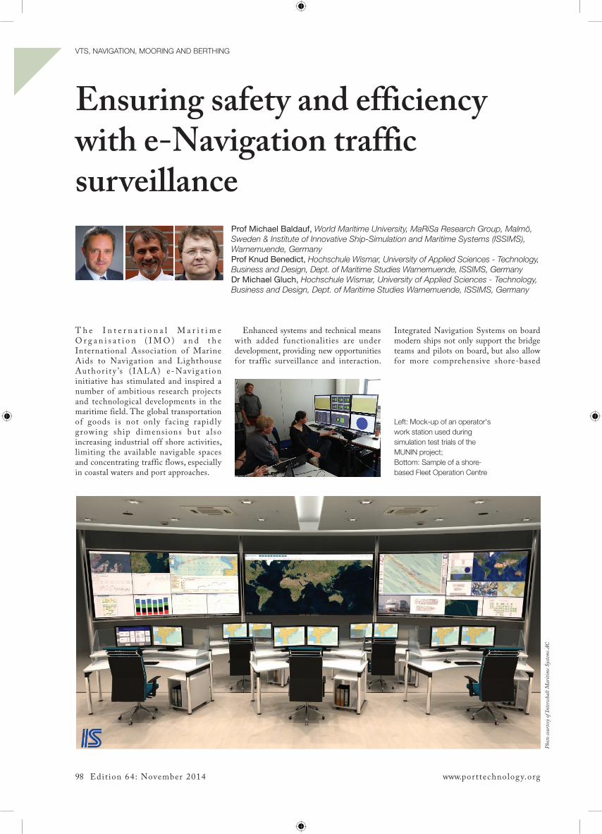
Left: Mock-up of an operator's work station used during simulation test trials of the MUNIN project; Bottom: Sample of a shore-based Fleet Operation Centre
Phot
o cou
rtesy
of In
tersch
alt M
ariti
me S
ystem
s AC
98 Edit ion 64: November 2014 www.por ttechnolog y.org
VTS, NaVIgaTION, MOOrINg aNd BerThINg

traffic monitoring, and even allow for the re-thinking of existing regimes and procedures of traffic management.
A sophisticated manoeuvring support tool using fast time simulation (FTS) technology will be introduced in this artic le. The application of this tool for on board support as well as for its potential integration into enhanced shore-based monitor ing processes when l inked wi th the ‘Mar i t ime Cloud ’ wi l l a lso be explored. The potential contribution to safer and environmentally-friendly manoeuvring regimes will be discussed and explained by means of a critical case study.
IntroductionThe IMO’s e-Navigation concept has provided the impetus for a range of research projects focusing on the utilisation and integration of new solutions in ship–shore communication and information exchange, providing novel solutions to the challenges facing the industry today.
The Access ibi l i t y for Shipping, Efficiency Advantages and Sustainability (ACCSEAS) project aims to advance maritime access in the North Sea region by developing intuitive tools to enable seafarers to make safe and effective navigational decisions. The areas of shipping congestion and limitations have been identified, and novel solutions are able to be developed, prototyped and demonstrated in e-Navigation test beds in the North Sea region. The aim is to harmonise maritime information and its exchange and in addition address training provision to support the real-world implementation of the solutions.
ACCSEAS works in tandem with the much larger MONALISA project that contributes developments to the ‘Motorways of the Sea’ initiative. This project focussed around ecologically efficient e-Navigation solutions supportive of EU strategy for the Baltic Sea region. The project laid the groundwork for the future international implementation of innovative solutions. The follow-up, MONALISA 2.0, seeks to develop the concept further by the implementation of measures in line with EU transport policies.
Supportive of the vis ion of the e-Navigation concept is the so called 'Maritime Cloud'. This can be utilised to populate pertinent data and information related to the ship domain (particularly manoeuvring characteristics beside length, breadth, draft and trim); voyage related details (voyage plan comprising waypoints, speed and course); and environmental/hydro-meteorological information (wind, sea state, waves, visibility).
This information can be utilised both on-board the ship domain and by any shore based control centre like a VTS for information sharing and effective decision-making. The security and integrity of information would need to be addressed; however, the 'Maritime Cloud' can perform an integral service for the implementation and achievements of future e-Navigation services.
Present situationS h i p d i m e n s i on s a r e c on s t a n t l y growing, and ship sizes have gone from carrying a capacity of 500-800 TEU in the 1950s, to the modern-day Maersk 'Triple E' class, which has capacities of over 18,000 TEU. In the near future, we can expect to see container ships with a capacity of 22,000 TEU with a length of 430m. On the one hand
Top: aCCSeaS Baseline Scenario of vessel traffic in the North Sea area, showing aIS based indication of the traffic situation in 2012, as well as prognosticated traffic figures for 2020+. Coloured areas indicate established and planned wind mill farm areas - clearly showing that they will impact present shipping routes; Bottom: humber TSS: display of intended route facilitating shore-based suggestion
Edit ion 64: November 2014 99
VTS, NaVIgaTION, MOOrINg aNd BerThINg

are the increasing ship sizes that defy imagination, while on the other we have ever increasing levels of offshore activity for oil exploration, drilling, installation
of wind farms, floating production storage and offloading (FPSO) units, oil rigs and platforms. There is a lack of harmonisation in the exclusion zones
surrounding such installations which can range from as much as 500m to 10 miles. Marine exclusion zones are set up and particularly sensitive sea areas (PSSA) are
Top: Visualising a vessel's actual situation-dependent operational limits in an eCdIS by means of FTS actual manoeuvring track (grey-dotted contours) and additional manoeuvring tracks for turning circle hard to starboard (green) and turning circle hard to port (red) as well as for crash stop (black) from actual motion parameters; Bottom: Vessel ordered hard starboard rudder - the display shows the contours of actual dynamic prediction (grey) are coinciding with the contours for the calculated turning circle to starboard side (green). The black shapes show the prediction for the alternative action of a combined turning and stopping manoeuvre (application developed by hS Wismar, ISSIMS in eU-funded MUNIN project)
100 Edit ion 64: November 2014 www.por ttechnolog y.org
VTS, NaVIgaTION, MOOrINg aNd BerThINg