computers and electronics in agriculture - sudan ... · pdf filesiva kumar balasundramd, mohd...
TRANSCRIPT

Computers and Electronics in Agriculture 93 (2013) 98–110
Contents lists available at SciVerse ScienceDirect
Computers and Electronics in Agriculture
journal homepage: www.elsevier .com/locate /compag
Agriculture Land Suitability Evaluator (ALSE): A decision and planningsupport tool for tropical and subtropical crops
0168-1699 � 2013 Elsevier B.V.http://dx.doi.org/10.1016/j.compag.2013.02.003
⇑ Corresponding author. Address: Geospatial Information Science ResearchCentre (GIS RC), Faculty of Engineering, Universiti Putra Malaysia, P.O. Box 43400UPM Serdang, Selangor, Kuala Lumpur, Malaysia. Tel.: +60 389467539 43; fax: +603894684 70.
E-mail addresses: [email protected] (R. Elsheikh), [email protected](Abdul Rashid B. Mohamed Shariff), [email protected], [email protected] (F. Amiri), [email protected] (N.B. Ahmad), [email protected] (S.K. Balasundram), [email protected] (M.A.M. Soom).
Open access under CC BY-NC-ND license.
Ranya Elsheikh a, Abdul Rashid B. Mohamed Shariff a, Fazel Amiri a,b,⇑, Noordin B. Ahmad c,Siva Kumar Balasundram d, Mohd Amin Mohd Soom e
a Geospatial Information Science Research Centre (GIS RC), Faculty of Engineering, Universiti Putra Malaysia, Malaysiab Faculty of Engineering Department, Islamic Azad University, Bushehr Branch, Iranc Faculty of Engineering Department, Universiti Putra Malaysia, Malaysiad Department of Agriculture Technology, Faculty of Agriculture, Universiti Putra Malaysia, Malaysiae Smart Farming Technology Centre of Excellence, Faculty of Engineering, Universiti Putra Malaysia, Malaysia
a r t i c l e i n f o
Article history:Received 19 April 2012Received in revised form 20 January 2013Accepted 5 February 2013
Keywords:Biophysical modelingExpert systemGISLand evaluationLand use planningMulti-criteria analysis
a b s t r a c t
Agricultural land suitability evaluation for crop production is a process that requires specialized geo-environmental information and the expertise of a computer scientist to analyze and interpret the infor-mation. This paper presents ALSE, an intelligent system for assessing land suitability for different types ofcrops in tropical and subtropical regions (e.g. mango, banana, papaya, citrus, and guava) based on geo-environmental factors that automates the process of evaluation and illustrates the results on an attributetable. Its main features include support of GIS capabilities on the digital map of an area with the FAO-SYSframework model with some necessary modifications to suit the local environmental conditions for landevaluation, and the support of expert knowledge through on spatial tools to derive criteria weights withtheir relative importance. A dynamic program for calculation of eigenvalues and eigenvectors of aweighting matrix is provided. Expertise and knowledge help ensure that ALSE databases represent real-istic, practicable and functional systems. It is useful for decision makers to determine the quality of landfor agricultural uses and is intended as a decision and planning support. Responsibility for any decisionsbased partly or wholly on the output of ALSE rests with the decision maker. ALSE ensures that the resultsare interpreted correctly within the relevant context, and contributes by maximizing land-use planningand decision support.
� 2013 Elsevier B.V. Open access under CC BY-NC-ND license.
1. Introduction
Land evaluation is a process of predicting land performanceover time according to the specific types of use (Zonneveld,1989; Rossiter, 1996; Lee and Yeh, 2009; Martin and Saha, 2009;Sonneveld et al., 2010). Agriculture land suitability assessment isdefined as the process of assessment of land performance whenused for alternative kinds of agriculture (He et al., 2011; Mu,2006; Prakash, 2003). The principle purpose of agriculture landsuitability evaluation is to predict the potential and limitation ofthe land for crop production (Pan and Pan, 2012).
Continuous utilization of agriculture land in past decades,regardless of land suitability has caused much more destructionthan provide the resources (FAO, 1976, 1983, 2007). Hence, properevaluation based on agriculture land use planning is essential tosolve this problem. Land evaluation methodologies have shiftedfrom broad based to specific assessment, with increasing use ofquantification (Elsheik et al., 2010; Nwer, 2006). Significantamount of literature and research has been dedicated to intelligentsystems for land use and management. Prominent land evaluationexpert systems that have been developed and introduced in recentyears are reviewed to enable comparative analysis. The land eval-uation computer system (LECS) based upon the FAO framework forpredicting local crop yields has been used to assess the land suit-ability for a variety of crops (Wood and Dent, 1983). However,the constraints of this system is simplicity and developed for areasin Sumatra (Nwer, 2006).
ALES on the other hand is an automated land evaluation systemthat allows land evaluators to build expert systems for land evalu-ation according to the method presented in the Food and Agricul-ture Organization Framework for land evaluation (Johnson and
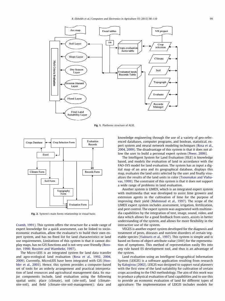
Fig. 1. Platforms structure of ALSE.
Fig. 2. System’s main forms relationship in visual basic.
R. Elsheikh et al. / Computers and Electronics in Agriculture 93 (2013) 98–110 99
Cramb, 1991). This system offers the structure for a wide range ofexpert knowledge for a quick assessment, can be linked to socio-economic evaluation, allow the evaluator’s to build their own ex-pert system, and has no fixed list for land characteristics or landuse requirements. Limitations of this system is that it cannot dis-play maps, has no GIS functions and is not very user friendly (Ross-iter, 1990; Rossiter and Wambeke, 1997).
The Micro-LEIS is an integrated system for land data transferand agro-ecological land evaluation (Rosa et al., 1992, 2004,2009). Currently, MicroLEIS have been integrated with GIS (Hoo-bler et al., 2003). Hence, this system provides a computer-basedset of tools for an orderly arrangement and practical interpreta-tion of land resources and agricultural management data. Its ma-jor components include, land evaluation using the followingspatial units: place (climate), soil (site-soil), land (climate-site-soil), and field (climate-site-soil-management); data and
knowledge engineering through the use of a variety of geo-refer-enced databases, computer programs, and boolean, statistical, ex-pert system and neural network modeling techniques (Rosa et al.,2004, 2009). The disadvantage of this system is that it does not al-low the user to build a personal expert system (Nwer, 2006).
The Intelligent System for Land Evaluation (ISLE) is knowledgebased, and models the evaluation of land in accordance with theFAO-SYS model for land evaluation. The system has as input a dig-ital map of an area and its geographical database, displays thismap, evaluates the land units selected by the user and finally visu-alizes the results of the land units in color (Tsoumakas and Vlaha-vas, 1999). The constraint of this system is that it does not supporta wide range of problems in land evaluation.
Another system is LIMEX, which is an integrated expert systemwith multimedia that was developed to assist lime growers andextension agents in the cultivation of lime for the purpose ofimproving their yield (Mahmoud et al., 1997). The scope of theLIMEX expert system includes assessment, irrigation, fertilization,and pest control. The expert system was augmented with multime-dia capabilities by the integration of text, image, sound, video, anddata which allows for a good feedback from users, assists in betterunderstanding of the system, and allows for more flexibility in theinteractive use of the system.
VEGES is another expert system developed for the diagnosis andtreatment of pests, diseases and nutrient disorders of certain veg-etable species (Yialouris et al., 1997). This system is simple and isbased on forms of object-attribute-value (OAV) for the representa-tion of symptoms. This method of representation easily fits intoany rule based ES development tool, and thus is an advantage ofthe system.
Land evaluation using an Intelligent Geographical InformationSystem (LEIGIS) is a software application resulting from researchby Kalogirou (2002). LEIGIS was designed to support rural plannerswith the first view of the land suitability for cultivation of certaincrops according to the FAO methodology. The aim of this work wasto produce a physical evaluation of land capabilities and to use thisto provide an economic evaluation of land for different types ofagriculture. The implementation of LEIGIS includes models for

Fig. 3. Main input fields for the different forms developed in the system design.
Fig. 4. Climate alternatives of the input information list for mango.
Table 1Climate suitability evaluation for the mango in the system.
No. Annual precipitate (mm) Rating of suitability (%) Suitability level
1 >2000 95 S12 1000–2000 85 S13 500–1000 60 S24 250–500 45 S35 <250 25 N16 0 N2
100 R. Elsheikh et al. / Computers and Electronics in Agriculture 93 (2013) 98–110
general cultivation and for specific crops (wheat, barley, maize,seed cotton, and sugar beet) (Kalogirou, 2002). This system is lim-ited to five crops and does not include characteristics such asclimate.
Model computer programs can also be implemented on theInternet through a web server, so that users can apply the modelsdirectly via a web browser. Jayasinghe and Machida (2008) devel-oped an interactive web-based GIS online consulting system withcrop-land suitability analysis, which provides information for to-mato and cabbage cultivation. This system has the benefit of avail-ability online, but is limited to two types of crop. There is a need forflexibility in the system with friendly user interface that allows theuser to identify and change the requirements based on local condi-tions. Also the system should be able to accommodate new crops.
MultiCriteria Evaluation (MCE) this framework consists of a fi-nite number of alternatives, explicitly known in the beginning ofthe solution process. Each alternative is represented by its perfor-mance in multiple criteria. The problem may be defined as findingthe best alternative for a decision maker (DM), or finding a set ofgood alternatives. The integration of MultiCriteria Decision Analy-sis Approaches (MCDAs) in a Geographical Information System(GIS) provides a powerful spatial decision support system whichoffers the opportunity to efficiently produce these land suitabilitymaps (Mendas and Delali, 2012). Hence, the current study har-nesses recent developments in using GIS–MCE as a smart tool in
supporting the decision making process for agriculture land evalu-ation purposes. The ALSE system was designed with specificknowledge based on GIS and multi criteria for predicting thegeo-environmental suitability of land for cultivation of major cropsin tropical and subtropical regions. The integration of GIS and theexpert systems in ALSE enable decision making with spatial data.
The FAO (1976) framework for land suitability involves the con-struction of matching tables or transfer functions, and subsequentcalculations of suitability. However, these processes are liable toerrors. Therefore, there are a great number of benefits to be gainedin automating the FAO procedures (Davidson, 1992; Rossiter,1990). The automated procedure describes how to carry out anevaluation exercise, including how to select land uses to evaluateand prepare evaluation (map) units. It also describes what factors(land suitabilities) to consider when evaluating certain generalkinds of land uses (e.g. forestry), and how to evaluate these factors(Rossiter, 1996).
The above method must however be supplemented with ananalytical method, which will infer from the set of land character-istics that affect a land use to the severity levels of the land suit-ability. Hence, Sys et al. (1993) presented a variance of themethod of matching tables, which assigns the correct severity levelof the land suitability, given data values for each land characteristic(Sys et al., 1993; Sys and Riquier, 1980). The advantages of thismethod are that it is simple, easy-to-understand, and has a graph-ical presentation. However, it has the disadvantage in that it can-not account for interactions between land characteristics.
The FAO-SYS system is a land evaluation model, based on FAO’sframework, with divisions of suitability classes that indicate degreeof suitability. These classes are: ‘S1’ = suitable, ‘S2’ = moderately

Fig. 5. Soil parameters and suitability assessment for mango.
Fig. 6. Flow chart of soil suitability calculation.
R. Elsheikh et al. / Computers and Electronics in Agriculture 93 (2013) 98–110 101
suitable, ‘S3’ = marginally suitable, ‘N1’ = unsuitable for economicreasons but otherwise marginally suitable, ‘N2’ = unsuitable forphysical reasons (FAO, 1976, 1983, 2007).
Fig. 7. Topography slopes ranges with the suitability evaluation.
2. ALSE system structure
ALSE is an intelligent system that desegregates the usefulness ofa GIS with an expert system for Agriculture land evaluation. It con-sists of the following main parts:
1. A Visual Basic program which provides the interface to theexpert system and integrated with GIS objects for judgingthe quality of agriculture land in selecting appropriatetypes of cultivation, and in planning management schemes.
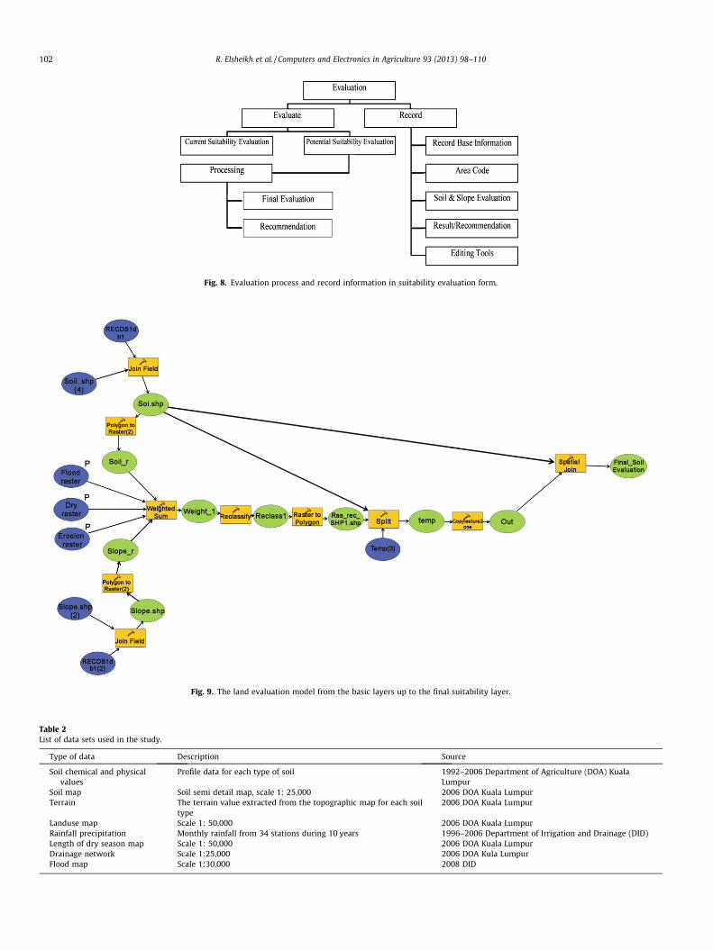
Fig. 8. Evaluation process and record information in suitability evaluation form.
Fig. 9. The land evaluation model from the basic layers up to the final suitability layer.
Table 2List of data sets used in the study.
Type of data Description Source
Soil chemical and physicalvalues
Profile data for each type of soil 1992–2006 Department of Agriculture (DOA) KualaLumpur
Soil map Soil semi detail map, scale 1: 25,000 2006 DOA Kuala LumpurTerrain The terrain value extracted from the topographic map for each soil
type2006 DOA Kuala Lumpur
Landuse map Scale 1: 50,000 2006 DOA Kuala LumpurRainfall precipitation Monthly rainfall from 34 stations during 10 years 1996–2006 Department of Irrigation and Drainage (DID)Length of dry season map Scale 1: 50,000 2006 DOA Kuala LumpurDrainage network Scale 1:25,000 2006 DOA Kula LumpurFlood map Scale 1:30,000 2008 DID
102 R. Elsheikh et al. / Computers and Electronics in Agriculture 93 (2013) 98–110

Fig. 10. Location of the study area.
R. Elsheikh et al. / Computers and Electronics in Agriculture 93 (2013) 98–110 103
2. Excel tables, which are used for selection of crop type. Add-ing new crop record is executed in the Excel programthrough the system.
3. The Arcmap Model Builder, which is used to organize andintegrate spatial processes to model the land suitability.The structure of the system is illustrated in Fig. 1, whilethe various parts are described in the following section.
The suitability analysis for geo-environmental factors (Ceballosand Blanco, 2003; Chuong, 2008, 2007) are calculate in Visual Basicand integrated within the GIS Model Builder through linking of ta-bles matching in ID. The input information is presented in differentforms, and each form is assigned to one information type, such asclimate data, soil data or topography data (Fig. 2).
The main panel is a simple platform, representing the six pri-mary tasks: crop selection, climate, soil, topography, evaluationand records manager. The user can implement each task by click-ing on the desired button, and a separate form would appear anddisappear according to user preference during the evaluationprocess.
The main panel offers the user an opportunity to explore andswitch between forms from the same platform (Fig. 3).
3. System implementation
Input information is listed in specific alternatives, and all valuesof the listed input information are written in a Data Base File (DBF).For each crop type, there are different values and different rangesfor each criterion, organized based on the suitability of the croptype, and divided into five suitability levels: S1, S2, S3, N1 and N2.
3.1. Crop selection
Selection of crop type is the first step to proceed with the sys-tem. The list of the alternative inputs changes depending on thecrop type. The system offers the ability to add a new type of cropby appending a new record to the crops record. Adding a new crop
record is executed in the Excel program through the system, andthe calculation will be based on the new crop information afterthe user has saved the record.
The selection of land qualities and land characteristics are pur-sued carefully considering the available data, texts, and literature.Therefore in this study, cultivation history and both local andworldwide knowledge, were brought together to identify the bestprediction for landuse requirements. Land characteristics and theirthreshold values were defined considering the optimum require-ments of mango (Mangifera indica), banana (Musa acuminata), pa-paya (Carica papaya), guava (Psidium guajava) and citrus (Citrusmedica). The data and information on the threshold values avail-able from literature and trials from local studies were used. Theland evaluation process was carried out by matching the land char-acteristics with crop requirements for each polygon.
3.2. Climate
The developed system considers the climate input as a rule tothe assessment process of land suitability. Climate information inthe system is described by two characteristics: the annual precip-itation (mm) and the length of the dry season per month. The finalevaluation of the climate suitability to a specific crop will be shownin an evaluation box at the right side of the form. For a mango cropwithin the study area, the climate form will appear as shown inFig. 4.
The system stores the selected input information and computesthe suitability level of the annual precipitation (mm) and thelength of the dry season per month. The final evaluation of climatesuitability is calculated based on mango requirement (Ikisan, 2003;Table 1).
3.3. Soil
Soil suitability in the soil form consists of five main qualities:nutrient availability, nutrient retention, rooting conditions, soilworkability and oxygen soil drainage class. The suitability

Fig. 11. ALSE tool interface of suitability map for mango cultivation based on: (a) soil parameters, (b) dry season climate, (c) slope parameter, (d) flood risk, and (e) erosionrisk.
104 R. Elsheikh et al. / Computers and Electronics in Agriculture 93 (2013) 98–110
assessment process for mango is presented in Fig. 5. Each quality inthe form has its evaluation results. The final result is the overallsuitability for soil, computed by the maximum limitation method(Fig. 6). The user can view the result in two ways: (i) current suit-ability evaluation, or (ii) potential suitability evaluation. Based onthe scope of suitability, there are two types of classifications in
the FAO Framework (1976): Current suitability refers to the suit-ability for a defined use of land in its present condition, withoutany major improvements in it. Potential suitability is for a defineduse, of land units in their condition at some future. In this researchthe potential suitability under the assumption of land would bemodified by fertilizer.

Table 3The result of weighting schemes for soil, slope, climate, flood and erosion scenarios.
Model run S1% S2% S3% N1% N2% Sum Scenario
1 6 56 27 8 3 100 Soil2 27 14 43 10 6 1003 12 60 22 4 2 1004 18 58 16 4 4 1005 30 48 12 5 5 1006 55 23 12 5 5 1007 63 15 12 4 6 1008 64 14 12 2 8 1009 64 14 12 2 8 100
10 5 59 29 5 2 100 Slope11 27 14 43 10 6 10012 12 67 15 4 2 10013 19 63 13 3 2 10014 28 51 15 3 3 10015 52 31 12 3 2 10016 55 28 12 3 2 10017 55 28 12 3 2 10018 55 28 12 3 2 10019 9 67 18 4 2 100 Climate20 27 14 43 10 6 10021 9 57 29 3 2 10022 11 51 32 4 2 10023 16 43 32 5 4 10024 19 38 29 10 4 10025 19 37 26 12 6 10026 20 36 26 12 6 10027 20 36 26 12 6 10028 20 60 14 4 2 100 Flood29 27 14 43 10 6 10030 3 54 34 7 2 10031 3 34 51 11 1 10032 1 26 45 27 1 10033 1 29 30 39 1 10034 1 31 13 52 3 10035 1 33 2 55 9 10036 0 1 34 56 9 10037 8 58 28 4 2 100 Erosion38 27 14 43 10 6 10039 11 62 19 6 2 10040 17 58 15 7 3 10041 32 43 14 8 3 10042 32 43 13 9 3 10043 47 28 12 10 3 10044 47 28 12 10 3 10045 47 28 12 10 3 100
R. Elsheikh et al. / Computers and Electronics in Agriculture 93 (2013) 98–110 105
3.4. Topography
Potential for mechanization indicates the topography of thearea. The impact of the topography on the land suitability is mea-sured by slope in degrees. Each crop type has a suitable range ofslopes, and the system classifies different slope ranges into five cat-egories in terms of crop suitability (Fig. 7).
3.5. Suitability evaluation
The suitability evaluation process begins after the user entersthe crop name and other necessary information on climate, soiland topography of the land. There are two ways to evaluate thesuitability: potential suitability or current suitability (Fig. 8).
3.6. Record manager
The final result is denoted as a new record in the database. Theuser is allowed to write down the primary information about thefield evaluation, such as land index number, user information, re-cord information, and other basic data. The record manager islinked to the record database directly, and allows the user to enter,explore, open, and edit the record. The record database table is the
linkage between the system and the GIS program. Every land par-cel has a unique code through which GIS software can relate towith the system outputs.
4. Land suitability model builder
A land suitability model was constructed using GIS capabilitiesand modeling functions. The GIS Model Builder was used to orga-nize and integrate spatial processes to model the land suitability.The spatial geo-environmental factors (e.g. soil, climate, slope, ero-sion and flood hazard) were integrated into the GIS environment asinformation layers and overlaid to produce overall land suitabilityassessment for a particular land utilization type. The suitabilityanalysis for geo-environmental factors is calculated in visual basicand integrated within the GIS Model Builder through linking of thetwo tables, considering matching in ID. The previously producedtwo layers for erosion (Dabral et al., 2008; Fistikoglu and Harman-cioglu, 2002; Lufafa et al., 2003) and flood (Fernandez and Lutz,2010; Meyer et al., 2009) are reclassified into five classes to pro-duce suitability input layers. The system is designed to achievethe suitability result directly with one click. It operates specificanalysis through ten different steps. Using the output tables fromthe Visual Basic program, the system links the suitability resultsto the soil and slope shape file of the same area by area index.
One script file is written in Python language to make one impor-tant step in the analysis (i.e. copy all of the parcels features to oneshape file). The system operates on five layers, which are soil, flood,dry, erosion and the slope of land. Soil and slope layers are features,while the others are in raster images. The first step is to assign thesuitability results, obtained by the Visual Basic system, to the soiland the slope layer using the area index code. ‘‘Join Field’’ is a toolused to make this step two times; one for the soil layer and anotherfor the slope layer.
The second step in the system is to convert the joined soil andslope features to raster image to make all of the layers in raster for-mat and allow the system to weight the overlaying layers usingweights obtained by Multi Criteria Analysis. A dynamic programfor the calculation of the eigenvalues and eigenvectors of a weight-ing matrix is provided. Weighted overlay is a technique for apply-ing a common scale of values to diverse and dissimilar inputs tocreate an integrated analysis (Malczewski, 1996, 2004). The result-ing layer is the suitability raster calculated from the five basiclayers.
The next two steps classify the weighted overlaid raster intofive classes based on suitability values, and then convert the clas-sified raster into polygon feature layers. Each polygon has a gridcode that equals to a suitability value. The suitability value refersto one of the five alternatives, 1, 2, 3, 4, and 5, where the value 1is the most suitable and 5 is the least suitable.
The resulting polygon feature contains many scattered polygonsassigned with suitability values, but without information on thearea code and other land data. This polygon feature is split to theoriginal land parcels using a split tool. The polygon features at thisstep are split to parcels, and the results are represented in shapefiles. Each file is one parcel. The parcel shape contains some poly-gons with different suitability values. To assemble the parcel shapefiles into one feature shape, a special Python script copies all of theparcels features into one shape file.
The final step in the model is to add the parcel information toeach polygon within the parcel boundary. A spatial join tool is usedto append parcels’ information to parcel location in reference to thesoil shape. The Model Builder developed for land suitability evalu-ation developed for a study area is presented in Fig. 9. The land suit-ability model is designed to accomplish a couple of spatial analyses,from the scratch layers up to the final suitability evaluation layer.

Fig. 12. The area of land suitability classes for: (a) soil, (b) slope, (c) climate, (d) flood, and (e) erosion scenario.
106 R. Elsheikh et al. / Computers and Electronics in Agriculture 93 (2013) 98–110
The integration of the information with the Visual Basic evaluationsystem is executed automatically through the model.
5. Sensitivity analysis
The general purpose of sensitivity analysis for the suitability cri-teria is to find out the influence of different criteria weights on thespatial pattern of the suitability classification. This is useful in
situations where uncertainties exist in the definition of the impor-tance of different criteria (Chen et al., 2009; Delgado and Sendra,2004; Store and Kangas, 2001). Sensitivity analysis is used to deter-mine the level of importance of each criterion and therefore at-tempts to reduce the subjectivity of weights (Feick and Hall,2004; Field et al., 2010). S, the suitability classification for majorcrops is defined on Rn, where n is the number of dimensionalspaces involved, i.e. it is a function of n variables:
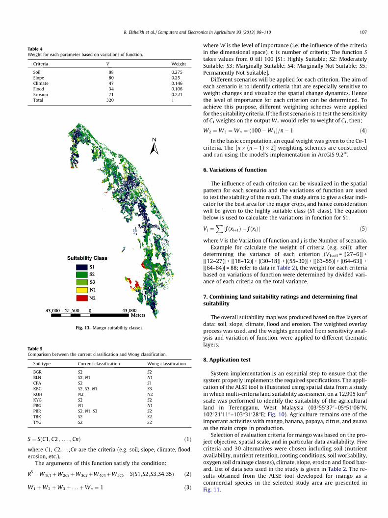
Table 4Weight for each parameter based on variations of function.
Criteria V Weight
Soil 88 0.275Slope 80 0.25Climate 47 0.146Flood 34 0.106Erosion 71 0.221Total 320 1
Fig. 13. Mango suitability classes.
Table 5Comparison between the current classification and Wong classification.
Soil type Current classification Wong classification
BGR S2 S2BLN S2, N1 N1CPA S2 S1KBG S2, S3, N1 S3KUH N2 N2KYG S2 S2PBG N1 N1PBR S2, N1, S3 S2TBK S2 S2TYG S2 S2
R. Elsheikh et al. / Computers and Electronics in Agriculture 93 (2013) 98–110 107
S ¼ SðC1;C2 ; . . . ; CnÞ ð1Þ
where C1, C2, . . . ,Cn are the criteria (e.g. soil, slope, climate, flood,erosion, etc.).
The arguments of this function satisfy the condition:
R5¼W1C1þW2C2þW3C3þW4C4þW5C5¼ SðS1;S2;S3;S4;S5Þ ð2Þ
W1 þW2 þW3 þ . . .þWn ¼ 1 ð3Þ
where W is the level of importance (i.e. the influence of the criteriain the dimensional space). n is number of criteria; The function Stakes values from 0 till 100 [S1: Highly Suitable; S2: ModeratelySuitable; S3: Marginally Suitable; S4: Marginally Not Suitable; S5:Permanently Not Suitable].
Different scenarios will be applied for each criterion. The aim ofeach scenario is to identify criteria that are especially sensitive toweight changes and visualize the spatial change dynamics. Hencethe level of importance for each criterion can be determined. Toachieve this purpose, different weighting schemes were appliedfor the suitability criteria. If the first scenario is to test the sensitivityof C1 weights on the output W1 would refer to weight of C1, then;
W2 ¼W3 ¼Wn ¼ ð100�W1Þ=n� 1 ð4Þ
In the basic computation, an equal weight was given to the Cn-1criteria. The [n � (n � 1) � 2] weighting schemes are constructedand run using the model’s implementation in ArcGIS 9.2�.
6. Variations of function
The influence of each criterion can be visualized in the spatialpattern for each scenario and the variations of function are usedto test the stability of the result. The study aims to give a clear indi-cator for the best area for the major crops, and hence considerationwill be given to the highly suitable class (S1 class). The equationbelow is used to calculate the variations in function for S1.
Vj ¼Xjf ðxiþ1Þ � f ðxiÞj ð5Þ
where V is the Variation of function and j is the Number of scenario.Example for calculate the weight of criteria (e.g. soil); after
determining the variance of each criterion (V1soil = |(27–6)| +|(12–27)| + |(18–12)| + |(30–18)| + |(55–30)| + |(63–55)| + |(64–63)| +|(64–64)| = 88; refer to data in Table 2), the weight for each criteriabased on variations of function were determined by divided vari-ance of each criteria on the total variance.
7. Combining land suitability ratings and determining finalsuitability
The overall suitability map was produced based on five layers ofdata: soil, slope, climate, flood and erosion. The weighted overlayprocess was used, and the weights generated from sensitivity anal-ysis and variation of function, were applied to different thematiclayers.
8. Application test
System implementation is an essential step to ensure that thesystem properly implements the required specifications. The appli-cation of the ALSE tool is illustrated using spatial data from a studyin which multi-criteria land suitability assessment on a 12,995 km2
scale was performed to identify the suitability of the agriculturalland in Terengganu, West Malaysia (03�5503700–05�5100600N,102�2101100–103�3102800E; Fig. 10). Agriculture remains one of theimportant activities with mango, banana, papaya, citrus, and guavaas the main crops in production.
Selection of evaluation criteria for mango was based on the pro-ject objective, spatial scale, and in particular data availability. Fivecriteria and 30 alternatives were chosen including soil (nutrientavailability, nutrient retention, rooting conditions, soil workability,oxygen soil drainage classes), climate, slope, erosion and flood haz-ard. List of data sets used in the study is given in Table 2. The re-sults obtained from the ALSE tool developed for mango as acommercial species in the selected study area are presented inFig. 11.

108 R. Elsheikh et al. / Computers and Electronics in Agriculture 93 (2013) 98–110
Fig. 11a shows the results of the endpoint assessment of landsuitability for mango based on importance of land conditions andconsidering the quality of soil characteristics including pH, H2O,depth to sulfuric horizon, CEC, base saturation, gravel and stones,effective soil depth, texture and structure and soil drainage class.The suitability classes in the map for each land characteristic wereproduced based on crop requirements. The overall physical suit-ability of land was taken from the most limiting land quality (LQrated as the worst). The new suitability value was assigned to eachsoil type. Ranking method was used (Malczewski, 2004) to classifythe soil in raster format. Fig. 11b illustrates the results of the suit-ability evaluation of mango based on the climatic parameter of dryseason months. The result indicates that all of the covered areaswithin the metrological station points are considered highly suit-able for mango based on crop requirement of annual precipitation.Therefore, dry season is deemed as the critical parameter in thecurrent evaluation. The results of topographic parameter on mangocultivation are presented in Fig. 11c. It was clear that the most suit-able area lies in the east of Terengganu State, and the suitabilitydecreases towards the southeast direction.
Fig. 11d shows the flood risk map created based on GIS andmulti criteria method. The suitable locations for mango cultivation,considering the flood parameter, are those locations of low poten-tial flood risk. The criterion maps were combined by logical opera-tions and criterion values were generated based on rankingmethod for each evaluation unit. Using pairwise compression thenormalized criterion weights were calculated as 0.387, 0.198,0.14, and 0.275, for annual rainfall, basin slope, soil type and drain-age network of the river basin, respectively. The significant find-ings showed a Consistency Ratio (CR) value of 0.05, which fellmuch below the threshold value of 0.1, indicating a high level ofconsistency. Hence, the weights are acceptable (Jankowski, 1995;Marinoni, 2004; Saaty, 2008).
Fig. 11e shows the erosion risk map for mango cultivation in thestudy area calculated using the Universal Soil Loss Equation (USLE)in GIS to determine the average annual soil loss (Dabral et al.,2008; Fistikoglu and Harmancioglu, 2002). The suitable locationsfor mango cultivation, considering the erosion parameter, are thoselocations that exhibit low potential erosion risk. From the map, itwas clear that the risky erosion locations are distributed in thesouthwestern areas where the slope was very steep.
For the purpose of sensitivity analysis, suitability maps forevery weighting scheme were created in GIS. The outputs (suitabil-ity maps) were compared to assess the influence of each criterionon the overall suitability for mango. Table 3 illustrates the visualassessment of the suitability classes and the percentage area calcu-lation of suitability classes that were conducted to interpret theoutput of the sensitivity analysis. From the tables, and by compar-ing the percentage area of the high suitability class (S1) for the dif-ferent weighting schemes, the sensitivity of the suitability criteriawas assessed. Fig. 12 shows the area of land suitability classes forthe different scenarios.
Increasing the soil weighting had a dramatic effect on the suit-ability pattern in the study area (Table 3 and Fig. 12a). When thesoil weighting was increased from 30% to 80%, the area of high suit-ability (S1) classes increased. The overall suitability classificationwas changed by the variation in soil weightings. The implicationof these findings is that soil factors have to be given suitableweighting to reflect its importance on the suitability of mango inthe study area.
Changing the weighting schemes for the slope resulted inchange to the suitability outputs (Table 2 and Fig. 12b). Increasingthe slope weighting had a dramatic effect on the suitability patternin the study area. The overall suitability classification was changedby the variation in slope weighting. The change in the suitabilitypattern indicated sensitivity to the slope in the study area. The
sensitivity analysis for climate also revealed that changing theweighting scheme changed the suitability pattern (Table 3 andFig. 12c). However, the change was not as dramatic as in the casesof soil and slope.
The high suitability class (S1) increased from 9% to 27% whenthe climate weighting was increased from 10% to 20%, respectively.The sensitivity analysis for the flood revealed that there was only aslight change in the highly suitable class when the flood weightingwas varied (Table 2 and Fig. 12d). For the erosion criterion, the re-sults indicated that there were minor changes in the highly suit-able class, but was less than the changes in the soil and slopecriteria (Table 3 and Fig. 12e).
The calculations of weights for each parameter based on the re-sults of variations of function are summarized in Table 4. The out-puts of sensitivity analysis for mango indicated how the suitabilitypatterns changed with variations in the weighting scheme (Ta-ble 4). For soil and slope criteria, there were significant changesin the highly suitable class when the weightings were changed.For erosion criterion, the results indicated that there were minorchanges in the highly suitable class, which was less than thechanges in the soil and slope criteria. The sensitivity analysis forthe flood and climate revealed that there was only a slight changein the highly suitable class when their weightings were varied.
The overall suitability map for mango was produced based onfive layers of data: soil, slope, climate, flood and erosion (Fig. 13).The weighted overlay process was used, and the weights generatedfrom sensitivity analysis and variation of function was applied tothe different layers. The results of the analysis indicated that 31%of the study area was identified as most suitable for mango (Class1), 55% of the area as moderately suitable area (Class 2), 9% percentas marginally suitable (Class 3) and the remaining portion (5%) wasnot suitable for mango (Class 4 and Class 5).
9. Validation and verification
A sample area within the study area was selected for model val-idation and verification. The implantation of the system indicatesthe suitability and limitation factors for each polygon. It is notedthat validation and accuracy of physical land evaluation that usea qualitative method is not possible (FAO, 1976; Rossiter, 1996).One of the methods that could be used for validation is to investi-gate if the selected crops were already produced in the region andthen a subjective comparison could be made. If the condition existsin a region, it reflects the results in a logical and acceptable man-ner, and then the findings become more viable. Local experts’ judg-ments and knowledge were consulted in the current study tovalidate the results of the model. There were 30 respondents in to-tal with 20 managers and 10 officials from other fields. The modeloutputs for the selected crops were viewed by the local experts.The experts’ opinions (DOA officials), which were based on experi-ence in the local context, revealed that the results of the model arein agreement with what is expected of the land in the study area.The officials were satisfied with the results and they keyed in thedata into the system successfully. Appendix (F) is a collection ofsome photographs taken during the validation was held. The clas-sification system used by the DOA in the Ministry of Agriculture isknown as the Wong classification. For further validation, Table 5was constructed to compare between the results of the samplearea based on 10 soil series type with Wong (soil–crop suitabilityclassification for Peninsular Malaysia). From the table, it was no-ticed that the results were in agreement with Wong classificationin term of soil suitability. The disagreement appeared when thewhole factors were considered, including environmental factors.In the current classification produced by this study the same seriescan occur at different locations, and each location has different
R. Elsheikh et al. / Computers and Electronics in Agriculture 93 (2013) 98–110 109
characteristics in terms of slope, climate and other environmentalfactors; which makes the results appear as S2 in one location andS3 in other location of the same soil series. This makes the currentclassification generally accepted since it evaluates the land by con-sidering physical and environmental factors. Currently, the Minis-try of Agriculture has started to implement this classificationsystem in other states, and extensive training on using the systemwas provided during 2009–2010 to use the new classification.
10. Conclusions
The integrative aspect of ALSE was very important. It demon-strates the enormous capabilities that the end user has when morethan one technology is interconnected in GIS. Thus, ALSE is a pow-erful system, as it provided many useful features in a single systemwith multidimensional fields for use in land evaluation. In general,the goal was to reach some conclusions on the quality of land, se-lect an appropriate cultivation technique, decide on crop rotation,and plan for the management of the land. The ALSE system is basedon knowledge of land use and management expertise, and usesintelligent techniques to simulate new knowledge.
The objectives and goals of this study were achieved with theaid of computer modeling, GIS, and Multi Criteria Analysis. Thework highlights the need to understand land capacity to supportappropriate crop cultivation. It provides optimum suitability clas-sification considering a wide range of multi-disciplinary alterna-tives. It also identifies land limitations and offers alternative landmanagement measures. The development of ALSE allows for stan-dardizing a framework for characterizing geo-environmental con-ditions (e.g. climate, soil, erosion, flood and topographic) relevantfor production of major crops (e.g. mango, banana, papaya, citrus,and guava). The ALSE identifies crop-specific conditions and sys-tematically computes the spatial and temporal data with maxi-mum potential. It would help land planners to make complexdecisions within a short period taking into account sustainability.The integration of GIS and Multi Criteria enables the managementof the criterion data, production of criterion layers, and calculationof attributes by means of spatial analysis, combining of decisioncriteria by modeling, and conducting sensitivity analyses and pro-duction of maps needed for land evaluation. Sensitivity analysisand variation of functions provided further confidence in the ALSE,and indicated priority areas for refinement. An important feature ofALSE is the capability of the system to be upgraded for each cropunder all weather condition.
References
Ceballos, S.A., Blanco, J.L., 2003. Delineation of suitable areas for crops using a multi-criteria evaluation approach and land use/cover mapping: a case study inCentral Mexico. Agricultural Systems 77, 117–136.
Chen, Y., Yu, J., Shahbaz, K., Xevi, E., 2009. A GIS-Based Sensitivity Analysis of Multi-Criteria Weights, 18th World IMACS/MODSIM Congress. Cairns, Australia.
Chuong, H.V., 2008. Multicriteria land suitabilty evaluation for crops using GIS atcommunity level in central Vietnam. In: International Symposium onGeoinformatics for Spatial Infrastructure Development in Earth and AlliedScie, Vietnam.
Chuong, H.V., 2007. Multi-criteria land suitability evaluation for selected fruit cropsin Hilly region of central Vietnam. Humboldt University, Berlin, Germany.
Dabral, P.P., Baithuri, N., Pandey, A., 2008. Soil erosion assessment in a hillycatchment of north eastern India using USLE, GIS and Remote sensing. WaterResources Management 22, 1783–1798.
Davidson, D.A., 1992. The evaluation of land resources. Longman Group UK Ltd.,London.
Delgado, M.G.m., Sendra, J.B., 2004. Sensitivity analysis in multicriteria spatialdecision-making: a review. Human and Ecological Risk Assessment: AnInternational Journal 10, 1173–1187.
Elsheik, A.R., Ahmad, N., Shariff, A., Balasundra, S., Yahaya, S., 2010. An agriculturalinvestment map based on geographic information system and multi-criteriamethod. Journal of Applied Sciences 10, 1596–1602.
FAO, 1976. A framework for land evaluation. Food and Agriculture Organization ofthe United Nations, Soils Bulletin 32. FAO, Rome.
FAO, 1983. Guidelines: land evaluation for rainfed agriculture. Food and AgricultureOrganization of the United Nations, Soils Bulletin 52. Rome, Italy.
FAO, 2007. Land Evaluation Towards a Revised Framework. Food and AgricultureOrganization of the United Nations, Rome, Italy.
Feick, R., Hall, B., 2004. A method for examining the spatial dimension of multi-criteria weight sensitivity. International Journal of Geographical InformationScience 18, 815–840.
Fernandez, D.S., Lutz, M.A., 2010. Urban flood hazard zoning in Tucumán Province,Argentina, using GIS and multicriteria decision analysis. Engineering Geology111, 90–98.
Field, P., Harvey, K., Strassberg, M., 2010. Integrating mediation in land use decisionmaking Lincoln Institute of Land Policy. Land Lines.
Fistikoglu, O., Harmancioglu, N., 2002. Integration of GIS with USLE in assessment ofsoil erosion. Water Resources Management 16, 447–467.
He, Y., Yao, Y., Chen, Y., Ongaro, L., 2011. Regional Land Suitability Assessment forTree Crops Using Remote Sensing and GIS. Computer Distributed Control andIntelligent Environmental Monitoring (CDCIEM) IEEE, Changsha, pp. 354–363.
Hoobler, B.M., Vance, G.F., Hamerlinck, J.D., Munn, L.C., Hayward, J.A., 2003.Applications of land evaluation and site assessment (LESA) and a geographicalinformation system in East Part Couny, Wyoming. Journal of Soil and WaterConservation 58, 105–112.
Ikisan, 2003. Mango Soil and Climate. <http://www.ikisan.com/crop%20specific/eng/links/ap_mangoSoils%20And%20Climate.shtml> (Retrieved March, 2003).
Jankowski, P., 1995. Integrating geographical information systems and multiplecriteria decision making methods. International Journal of GeographicInformation System 9, 251–273.
Jayasinghe, P.K.S., Machida, T., 2008. Web-based GIS online consulting system withcrop land suitability identification. Agriculture Information Research 17, 13–19.
Johnson, A., Cramb, R., 1991. Development of a simulation based land evaluationsystem using crop modelling, expert systems and risk analysis. Soil Use andManagement 7, 239–246.
Kalogirou, S., 2002. Expert systems and GIS: an application of land suitabilityevaluation. Computers, Environment and Urban Systems 26, 89–120.
Lee, T.M., Yeh, H.C., 2009. Applying remote sensing techniques to monitor shiftingwetland vegetation: a case study of Danshui River estuary mangrovecommunities, Taiwan. Ecological Engineering 35, 487–496.
Lufafa, A., Tenywa, M.M., Isabirye, M., Majaliwa, M.J.G., Woomer, P.L., 2003.Prediction of soil erosion in a Lake Victoria basin catchment using a GIS-based Universal Soil Loss model. Agricultural Systems 76, 883–894.
Mahmoud, M., Rafeh, M., Rafea, A., 1997. LIMEX: An Integrated Multimedia ExpertSystem for Lime Management. 5th International conference on artificialintelligence applications, Egyptian Computer Society (EGS), Cairo, Egypt, 27February - 3 March, 1997.
Malczewski, J., 1996. A GIS-based approach to multiple criteria group decisionmaking. International Journal of Geographical Information Systems 10, 955–971.
Malczewski, J., 2004. GIS-based land-use suitability analysis: a critical overview.Progress in Planning 62, 3–65.
Marinoni, O., 2004. Implementation of the analytical hierarchy process with VBA inArcGIS. Computers and Geosciences 30, 637–646.
Martin, D., Saha, S.K., 2009. Land evaluation by integrating remote sensing and GISfor cropping system analysis in a watershed. Current Science 96, 1.
Mendas, A., Delali, A., 2012. Integration of MultiCriteria Decision Analysis in GIS todevelop land suitability for agriculture: application to durum wheat cultivationin the region of Mleta in Algeria. Computers and Electronics in Agriculture 83,117–126.
Meyer, V., Scheuer, S., Haase, D., 2009. A multicriteria approach for flood riskmapping exemplified at the Mulde river, Germany. Natural Hazards 48, 17–39.
Mu, Y., 2006. Developing a Suitability Index for Residential Land Use: A Case Studyin Dianchi Drainage Area. University of Waterloo, Canada.
Nwer, B.A.B., 2006. The Application of Land Evaluation Technique in the North-Eastof Libya. Faculty of Environment. Cranfield University, Silsoe.
Pan, G., Pan, J., 2012. Research in crop land suitability analysis based on GIS.Computer and Computing Technologies in Agriculture 365, 314–325.
Prakash, T.N., 2003. Land Suitability Analysis for Agricultural Crops: A FuzzyMulticriteria Decision Making Approach, Science in Geoinformatics. ITC,Netherlands, pp. 6–13.
Rosa, D.D.l., Moreno, J.A., Garcia, L.V., Almorza, J., 1992. MicroLEIS: a microcomputerbased Mediterranean land evaluation information system. Soil Use andManagement 8, 89–96.
Rosa, D.D.L., Mayol, F., Diaz-Pereira, E., Fernandez, M., 2004. A land evaluationdecision support system (MicroLEIS DSS) for agricultural soil protection: withspecial reference to the Mediterranean region. Environmental Modelling &Software 19, 929–942.
Rosa, D.D.L., Anaya-Romero, M., Diaz-Pereira, E., Heredia, N., Shahbazi, F., 2009. Soilspecific agro-ecological strategies for sustainable land use. A case study byusing MicroLEIS DSS in Sevilla province (Spain). Land Use Policy 6, 1055–1065.
Rossiter, D.G., 1990. ALES: a framework for land evaluation using a microcomputer.Soil Use & Management 6, 7–20.
Rossiter, D.G., 1996. A theoretical framework for land evaluation. Geoderma 72,165–190.
Rossiter, D.G., Wambeke, A.R.V., 1997. Automated Land Evaluation System ALESVersion 4.65 User’s Manual. Cornell University.
Saaty, T.L., 2008. Decision making with the analytic hierarchy process. InternationalJournal of Services Sciences 1, 83–98.

110 R. Elsheikh et al. / Computers and Electronics in Agriculture 93 (2013) 98–110
Sonneveld, M.P.W., Hack-ten Broeke, M.J.D., van Diepen, C.A., Boogaard, H.L., 2010.Thirty years of systematic land evaluation in the Netherlands. Geoderma 156,84–92.
Store, R., Kangas, J., 2001. Integrating spatial multi-criteria evaluation and expertknowledge for GIS-based habitat suitability modelling. Landscape and UrbanPlanning 55, 79–93.
Sys, C., Ranst, E.V., Debaveye, J., Beernaert, F., 1993. Land evaluation part III croprequirements. Agricultural publications General Administration forDevelopment Cooperation, Belguim.
Sys, C., Riquier, J., 1980. Ratings of FAO/UNESCO Soil Units for Specific CropProduction. Food and Agriculture Organisation of the United Nation, Rome, Italy.
Tsoumakas, G., Vlahavas, I., 1999. ISLE: an intelligent system for land evaluation.Proceedings ACAI 99, 26–32.
Wood, S.R., Dent, F.J., 1983. LECS. A land evaluation computer systemmethodology. Bogor: Ministry of Agriculture/PNUD/FAO, Centre for SoilResearch, Indonesia.
Yialouris, C., Passam, H., Sideridis, A., 1997. VEGES: a multilingual expert system forthe diagnosis of pests, diseases and nutritional disorders of six greenhousevegetables. Computers and Electronics in Agriculture 19, 55–67.
Zonneveld, I.S., 1989. The land unit – a fundamental concept in landscape ecology,and its applications. Landscape Ecology 3, 67–86.