community bushfire protection plan - tfs online · community bushfire protection plan ... 3) if you...
TRANSCRIPT
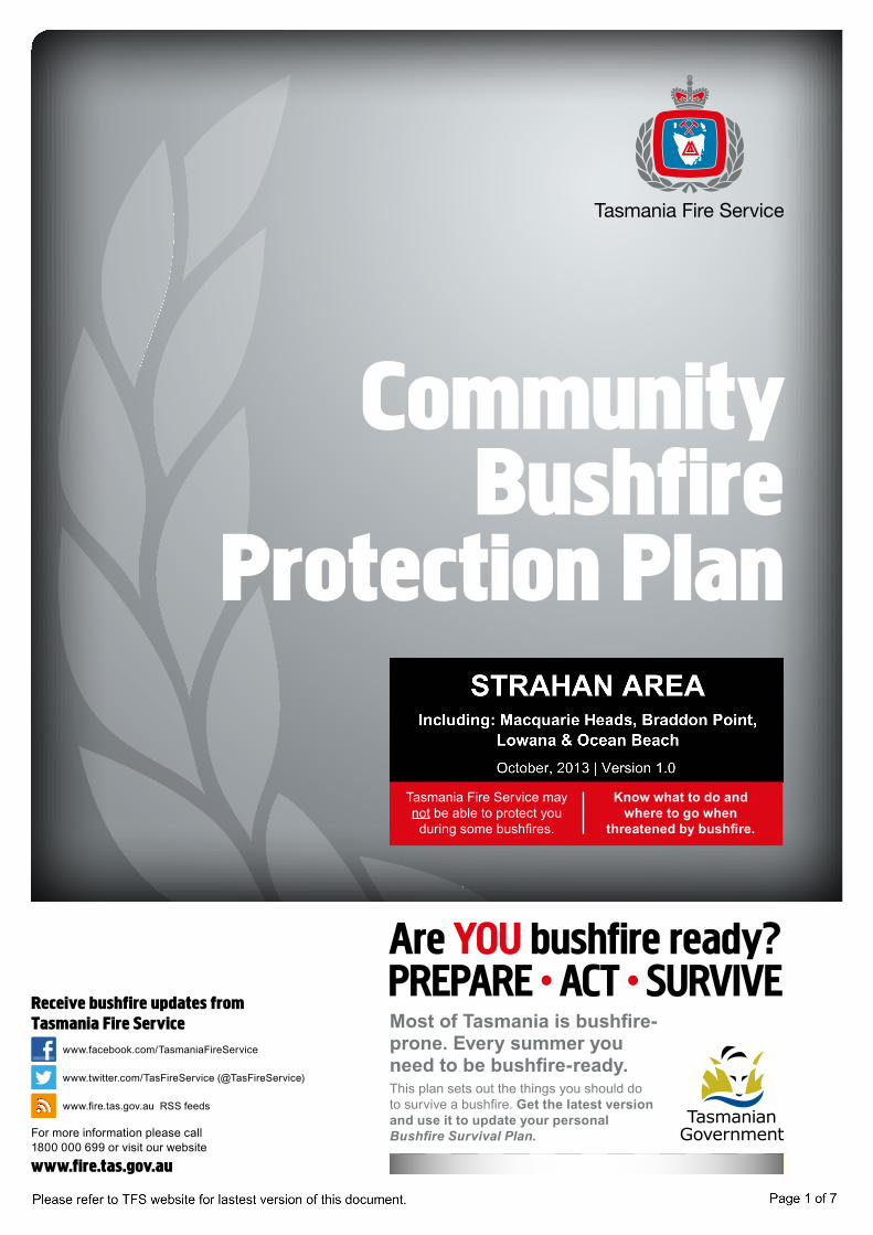
Community Bushfire
Protection Plan
This plan sets out the things you should do to survive a bushfire. Get the latest version and use it to update your personal Bushfire Survival Plan.
Most of Tasmania is bushfire-prone. Every summer you need to be bushfire-ready.
Tasmania Fire Service may not be able to protect you
during some bushfires.
Know what to do and where to go when
threatened by bushfire.
Receive bushfire updates from Tasmania Fire Service
For more information please call 1800 000 699 or visit our website www.fire.tas.gov.au
www.facebook.com/TasmaniaFireService
www.twitter.com/TasFireService (@TasFireService)
www.fire.tas.gov.au RSS feeds

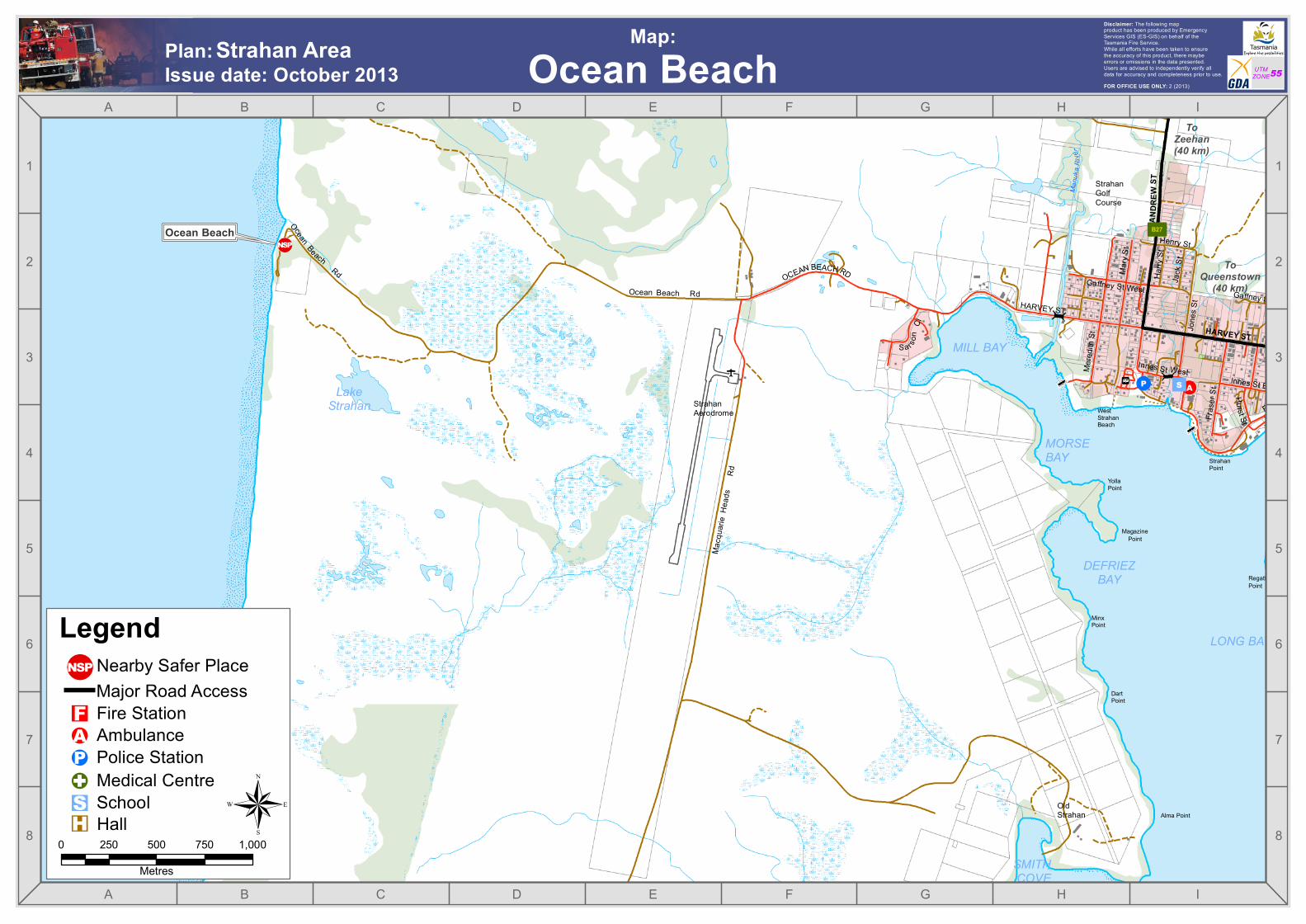
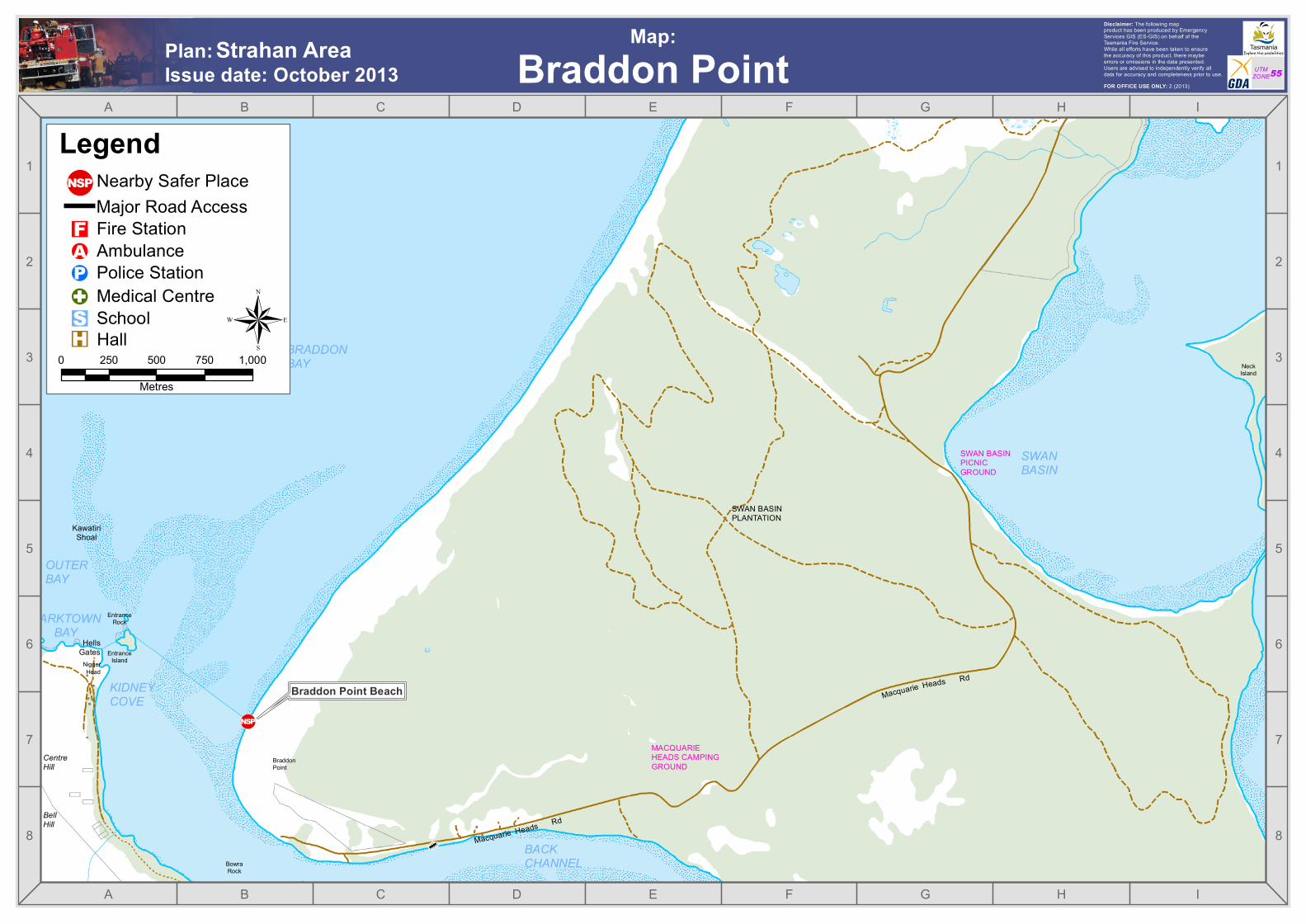
NEARBY SAFER PLACESA nearby safer place is somewhere close by you should be able to reach quickly and safely, and that gives shelter from radiant heat.
Using nearby safer places is not without risk. They are a last resort, not your only option.
Nearby safer places may include town centres; ground level water e.g. rivers, in-ground pools, dams; large open areas e.g. beaches, ploughed or green fields, golf courses, recreation grounds and community parks with very short grass; and approved bushfire bunkers.
• List other nearby safer places, close to where you live, in your personal Bushfire Survival Plan.
• Prepare your home and identify nearby safer places. Otherwise, leave early.
• Travelling through fire impacted areas is unsafe and should be avoided, even in a car.
In an emergency dial triple zero 000 or if a TTY user call 106
Get your free Bushfire Survival Plan &Bushfire Prepare to Survive booklet & DVDwww.fire.tas.gov.au | Free call 1800 000 699
NSPPREPARE | before the fire1) Prepare your home for bushfire. • Use the Tasmania Fire Service Bushfire Prepare to Survive
booklet or DVD. • Even if you plan to leave early, preparing your home
gives you another shelter option, and firefighters a better chance to save it.
2) Decide what you will do and write down your plan. • Will you leave early, or will you stay and defend your home? • Decide now, and fill out your Bushfire Survival Plan.3) If you can, talk with your neighbours. • What are their plans? Are they aware of your plans?4) Review your insurance policy. • Are your home and contents covered for bushfire?
ACT | when fires are likely, or nearby1) Keep informed. • Check the weather forecast and Fire Danger Rating daily. • Listen to ABC Local Radio, monitor the Tasmania Fire
Service website www.fire.tas.gov.au and watch for smoke and fires.
• If bushfires are in your area, don’t wait for an official warning.2) Put your Bushfire Survival Plan into action. • The safest option for all bushfires is to leave early,
before a bushfire threatens you and your home. - Consider leaving immediately if ‘Severe’, ‘Extreme’ or
‘Catastrophic’ Fire Danger Ratings are forecast for the following day.
- Leaving the day before because of a bad fire danger forecast isn’t always practical. So, if waiting until a bushfire breaks out in your district, leave early before roads are cut by fire, fallen trees or power-lines.
- Be prepared to stay away for several days. Head away from any fires; towards a town centre is often best.
• A safe option for some bushfires. For less intense bushfires, you may stay & defend your
home if: a) You have prepared it for bushfires, with fire-fighting
equipment and plenty of water. b) You are fit and emotionally prepared (it is best to
evacuate children and other dependents early). • An unsafe option is to ‘wait and see’, then flee at the
last minute. - If you don’t have a plan, leave immediately. - If a bushfire catches you by surprise and it’s unsafe
to stay at home but too late to leave the area, go to a nearby safer place and wait for the fire front to pass though.
SURVIVE | after the fire1) Make sure everyone’s safe, check on your neighbours if you can.2) Tune in to the Information Sources (listed on the map overleaf).3) If at home, put out any embers and spot-fires threatening
your home.4) If your home is destroyed, contact your local council for
assistance.
Add nearby safer places to yourBushfire Survival Plan.
Nearby Safer Places:
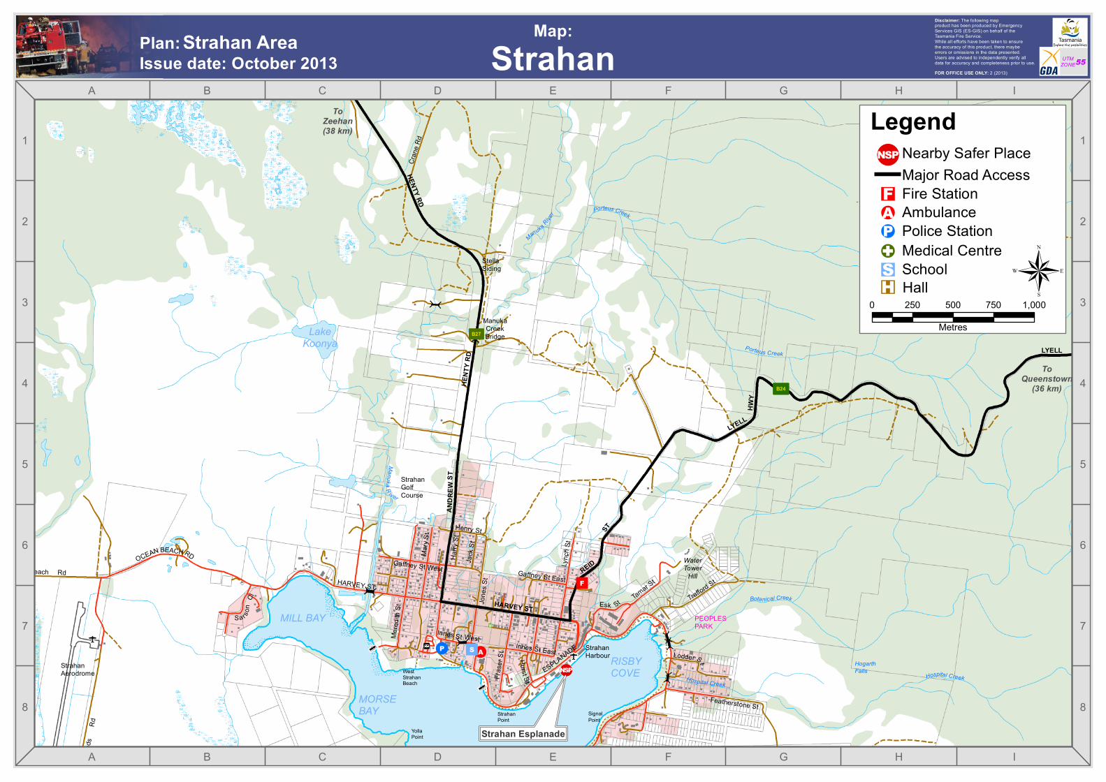
ManukaCreekBridge
MILL BAY
StrahanAerodrome
MORSEBAY
WestStrahanBeach
StrahanGolfCourse
PEOPLESPARK
StrahanHarbour
HogarthFalls
WaterTower
Hill
StellaSiding
SignalPoint
StrahanPoint
YollaPoint
RISBYCOVE
LakeKoonya
!A
"F
!P
+
+ !¼
p
p
"S
REID
ST
LYELL
HWY
LYELL HWY
HENTY RD
AND R
E WST
HARVEY ST
Gaffney St East
Innes St East
Gaffney St West
Henry St
Jack
St
Mary
St
Tamar St
Featherstone St
Esk StSa rso
nCl
Cran
e Rd
Macq
uarie
Head
sRd
Frase
r St
Trafford St
Lync
h St
Mered
ith St
Ocean Beach RdHurst St
Harry
St
Jone
s St
Innes St West
HARVEY ST
OCEAN BEACH RD
ESPLANADELodder St
HENT
Y RD
ToZeehan(38 km)
ToQueenstown
(36 km)
!(N PSHospital Creek
Hospital Creek
Botanical Creek
Porteus Creek
Porteus Creek
ManukaR iver
Manuka River
³B27
³B24
A
A
B
B
C
C
D
D
E
E
F
F
G
G
H
H
I
I
8 8
7 7
6 6
5 5
4 4
3 3
2 2
1 1
FOR OFFICE USE ONLY: 2 (2013)
Disclaimer: The following mapproduct has been produced by EmergencyServices GIS (ES-GIS) on behalf of theTasmania Fire Service.While all efforts have been taken to ensurethe accuracy of this product, there maybeerrors or omissions in the data presented.Users are advised to independently verify alldata for accuracy and completeness prior to use. UTM
ZONE55
Strahan Esplanade
Strahan AreaIssue date: October 2013 StrahanPlan: Map:
0 250 500 750 1,000Metres
®
Nearby Safer Place
"S!A"F!G!P
Major Road Access
School
Fire Station
Police StationAmbulance
Hall
Medical Centre
Legend
"H
!(N PS
Alma Point
MILL BAY
LONG BAY
StrahanAerodrome
OldStrahan
DEFRIEZBAY
MORSEBAY
WestStrahanBeach
StrahanGolfCourse
MinxPoint
MagazinePoint
RegattaPoint
StrahanPoint
YollaPoint
DartPoint
SMITHCOVE
LakeStrahan
!A!P
+
+ !¼p
"S
ANDR
EWST
HARVEY ST
Gaffney St East
Innes St East
Gaffney St West
Henry St
Jack
St
Mary
St
Sa rson
Cl
Macq
uarie
Head
sRd
Frase
r St
Mered
ith St
Ocean BeachRd
Ocean Beach Rd
Hurst St
Harry
St
Jone
s St
Innes St West
HARVEY ST
OCEAN BEACH RD
ESPLANADE
ToQueenstown
(40 km)
ToZeehan(40 km)
!(N PS
Manu
kaRi
ver
³B27
A
A
B
B
C
C
D
D
E
E
F
F
G
G
H
H
I
I
8 8
7 7
6 6
5 5
4 4
3 3
2 2
1 1
FOR OFFICE USE ONLY: 2 (2013)
Disclaimer: The following mapproduct has been produced by EmergencyServices GIS (ES-GIS) on behalf of theTasmania Fire Service.While all efforts have been taken to ensurethe accuracy of this product, there maybeerrors or omissions in the data presented.Users are advised to independently verify alldata for accuracy and completeness prior to use. UTM
ZONE55
Ocean Beach
Strahan AreaIssue date: October 2013 Ocean BeachPlan: Map:
0 250 500 750 1,000Metres
®
Nearby Safer Place
"S!A"F!G!P
Major Road Access
School
Fire Station
Police StationAmbulance
Hall
Medical Centre
Legend
"H
!(N PS
BraddonPoint
NeckIsland
SWANBASIN
BRADDONBAY
OUTERBAY
DARKTOWNBAY
HellsGates
MACQUARIEHEADS CAMPINGGROUND
SWAN BASINPICNICGROUND
CentreHill
BellHill
BowraRock
EntranceRock
EntranceIsland
SWAN BASINPLANTATION
BACKCHANNEL
NiggerHead
KawatiriShoal
KIDNEYCOVE
+ Macquarie Heads Rd
Macquarie Heads Rd
!(N PS
A
A
B
B
C
C
D
D
E
E
F
F
G
G
H
H
I
I
8 8
7 7
6 6
5 5
4 4
3 3
2 2
1 1
FOR OFFICE USE ONLY: 2 (2013)
Disclaimer: The following mapproduct has been produced by EmergencyServices GIS (ES-GIS) on behalf of theTasmania Fire Service.While all efforts have been taken to ensurethe accuracy of this product, there maybeerrors or omissions in the data presented.Users are advised to independently verify alldata for accuracy and completeness prior to use. UTM
ZONE55
Braddon Point Beach
Strahan AreaIssue date: October 2013 Braddon PointPlan: Map:
0 250 500 750 1,000
Metres
®
Nearby Safer Place
"S!A"F!G!P
Major Road Access
School
Fire Station
Police StationAmbulance
Hall
Medical Centre
Legend
"H
!(N PS

CAPE SORELLHISTORIC
SITE
BraddonPoint
LucasPoint
MOUNTANTILL
MOUNTOBVIOUS
PraterRock
TrumpeterRock
NapierHills
WattsHill
BONNETBAY
PILOTBAY
EDWARDSBAY
BRADDONBAY
OUTERBAY
PINE BAY
DARKTOWNBAY
GrandfathersBeach
PebblyBeach
PilotBeach
TiddysBeach
CharleysBeach
HannantsBight
HellsGates
OlsenReef
GateHill
CentreHill
BellHill
GoatHill
WellingtonHead
CapeSorell
BonnetIsland
BowraRock
KaritaneRock
RockIsland
SplitRock
The Cap
TidegaugeRock
TurnersRock
BirdIslets
EntranceRock
EntranceIsland
TrumpeterPoint
NiggerHead
WoodingPoint Kawatiri
Shoal
PelicanSpit
KIDNEYCOVE
HeronPond
TealPond
CapeSorellLighthouse
MACQUARIEHEADS
7468
!(N PS
!(N PS
A
A
B
B
C
C
D
D
E
E
F
F
G
G
H
H
I
I
8 8
7 7
6 6
5 5
4 4
3 3
2 2
1 1
FOR OFFICE USE ONLY: 2 (2013)
Disclaimer: The following mapproduct has been produced by EmergencyServices GIS (ES-GIS) on behalf of theTasmania Fire Service.While all efforts have been taken to ensurethe accuracy of this product, there maybeerrors or omissions in the data presented.Users are advised to independently verify alldata for accuracy and completeness prior to use. UTM
ZONE55
Braddon Point Beach
Strahan AreaIssue date: October 2013 Macquarie HeadsPlan: Map:
0 250 500 750 1,000
Metres
®
Nearby Safer Place
"S!A"F!G!P
Major Road Access
School
Fire Station
Police StationAmbulance
Hall
Medical Centre
Legend
"H
!(N PS
Pilot Beach
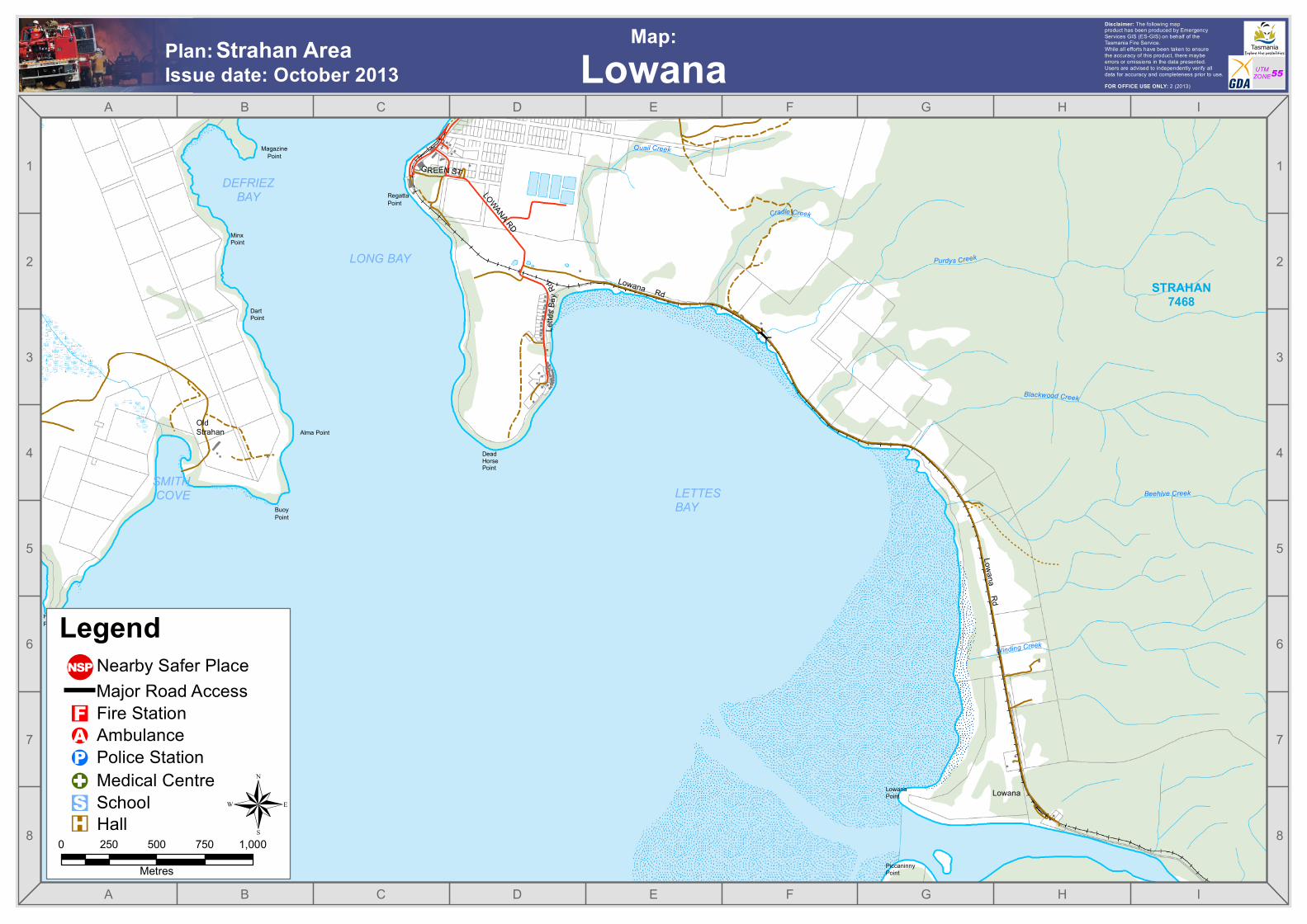
DeadHorsePoint
BuoyPoint
Alma Point
LowanaPoint
PiccaninnyPoint
LETTESBAY
LONG BAY
OldStrahan
DEFRIEZBAY
Lowana
MinxPoint
MagazinePoint
HenryPoint
RegattaPoint
DartPoint
SMITHCOVE
STRAHAN7468
Lowana Rd
Lowana Rd
L ette
s Bay
Rd
GREEN ST
LOWANA RD
Quail Creek
Winding Creek
Cradle Creek
Beehive Creek
Blackwood Creek
Purdys Creek
A
A
B
B
C
C
D
D
E
E
F
F
G
G
H
H
I
I
8 8
7 7
6 6
5 5
4 4
3 3
2 2
1 1
FOR OFFICE USE ONLY: 2 (2013)
Disclaimer: The following mapproduct has been produced by EmergencyServices GIS (ES-GIS) on behalf of theTasmania Fire Service.While all efforts have been taken to ensurethe accuracy of this product, there maybeerrors or omissions in the data presented.Users are advised to independently verify alldata for accuracy and completeness prior to use. UTM
ZONE55Strahan Area
Issue date: October 2013 LowanaPlan: Map:
0 250 500 750 1,000
Metres
®
Nearby Safer Place
"S!A"F!G!P
Major Road Access
School
Fire Station
Police StationAmbulance
Hall
Medical Centre
Legend
"H
!(N PS