community bushfire protection plan - tasmania … bushfire protection plan this plan sets out the...
TRANSCRIPT

Community Bushfire
Protection Plan
This plan sets out the things you should do to su i e a ush e Get the latest version and use it to update your personal
.
ost o as ania is ush reprone. Every summer you need to e ush re ready.
Tasmania Fire Service may not be able to protect you
during some bush res
Know what to do and where to go when
threatened y ush re.
Receive bushfire updates from Tasmania Fire Service
For more information please call 1800 000 699 or visit our website www.fire.tas.gov.au
www faceboo com TasmaniaFireService
www twitter com TasFireService TasFireService
www re tas gov au RSS feeds
Page 1 of 8Please refer to TFS website for lastest version of this document.
September, 2013 | Version 1.0
BICHENO AREA Including: Douglas River & Seymour
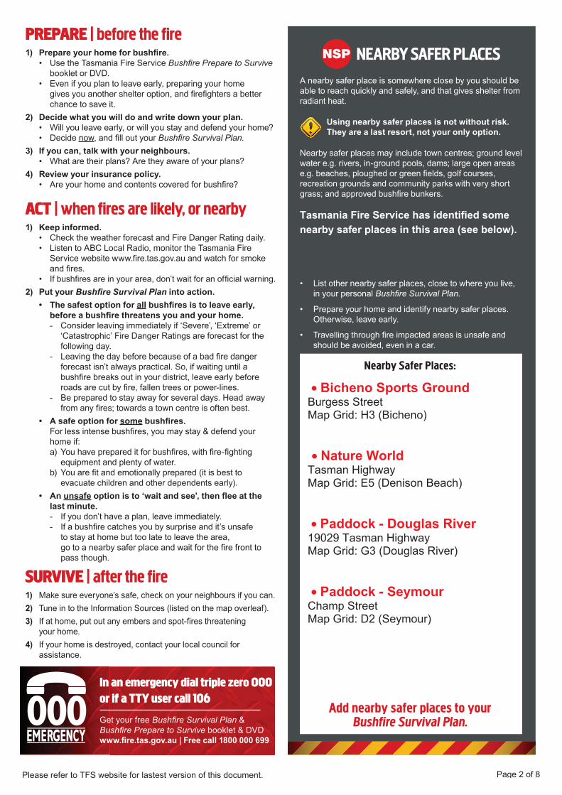
NEARBY SAFER PLACESA nearby safer place is somewhere close by you should be able to reach uic ly and safely and that gives shelter from radiant heat
Using nearby safer places is not without risk. They are a last resort, not your only option.
Nearby safer places may include town centres; ground level water e g rivers in ground pools dams; large open areas e g beaches ploughed or green elds golf courses recreation grounds and community par s with very short grass; and approved bush re bun ers
ist other nearby safer places close to where you live in your personal
repare your home and identify nearby safer places therwise leave early
Travelling through re impacted areas is unsafe and should be avoided even in a car
In an emergency dial triple zero 000 or if a TTY user call 106
Get your free & boo let &
www. re.tas.gov.au ree call
NSPPREPARE | before the fire
repare your home for bush re. • Use the Tasmania Fire Service
boo let or • ven if you plan to leave early preparing your home
gives you another shelter option and re ghters a better chance to save it
ecide what you will do and write down your plan. • ill you leave early or will you stay and defend your home • ecide now and ll out your
f you can, talk with your neighbours. • hat are their plans Are they aware of your plans
eview your insurance policy. • Are your home and contents covered for bush re
ACT | when fires are likely, or nearby Keep informed.
• hec the weather forecast and Fire anger Rating daily • isten to A ocal Radio monitor the Tasmania Fire
Service website www re tas gov au and watch for smo e and res
• f bush res are in your area don t wait for an of cial warning ut your into action.
• The safest option for all bush res is to leave early, before a bush re threatens you and your home.
onsider leaving immediately if Severe treme or atastrophic Fire anger Ratings are forecast for the
following day eaving the day before because of a bad re danger
forecast isn t always practical So if waiting until a bush re brea s out in your district leave early before roads are cut by re fallen trees or power lines
e prepared to stay away for several days ead away from any res; towards a town centre is often best
• A safe option for some bush res. For less intense bush res you may stay & defend your
home if: a ou have prepared it for bush res with re ghting
e uipment and plenty of water b ou are t and emotionally prepared it is best to
evacuate children and other dependents early • An unsafe option is to wait and see , then ee at the
last minute. f you don t have a plan leave immediately f a bush re catches you by surprise and it s unsafe
to stay at home but too late to leave the area go to a nearby safer place and wait for the re front to pass though
SURVIVE | after the fire a e sure everyone s safe chec on your neighbours if you can Tune in to the nformation Sources listed on the map overleaf f at home put out any embers and spot res threatening
your home f your home is destroyed contact your local council for
assistance
Add nearby safer places to yourBushfire Survival Plan.
Nearby Safer Places:
Page 2 of 8Please refer to TFS website for lastest version of this document.
• Bicheno Sports Ground Burgess Street Map Grid: H3 (Bicheno) • Nature World Tasman Highway Map Grid: E5 (Denison Beach) • Paddock - Douglas River 19029 Tasman Highway Map Grid: G3 (Douglas River) • Paddock - Seymour Champ Street Map Grid: D2 (Seymour)
Tasmania Fire Service has identified some nearby safer places in this area (see below).

SEYMOUR CONSERVATIONAREA
CoalPoint
AllenPoint
od
BlindCreekBridge
DoctorsCreekBridge
SeymourBeach
SeymourSwamp
SeymourBridge
BlackDog Reef
SneakerRocks
LongPoint
THEBASIN
SEYMOUR7215
TASM
AN
H
WY
TASMAN
HWY
Mac
quar
ie S
t
*Champ St
ToSt Marys(24km)
ToBicheno(13km)
!(N PS
Douglas River
Blind Creek
Blind Creek
Doctors Creek
³A3
A
A
B
B
C
C
D
D
E
E
F
F
G
G
H
H
9 9
8 8
7 7
6 6
5 5
4 4
3 3
2 2
1 1
FOR OFFICE USE ONLY: 2 (2013)
Disclaimer: The following mapproduct has been produced by EmergencyServices GIS (ES-GIS) on behalf of theTasmania Fire Service.While all efforts have been taken to ensurethe accuracy of this product, there maybeerrors or omissions in the data presented.Users are advised to independently verify alldata for accuracy and completeness prior to use.
UTMZONE55SeymourIssue date: September 2013
Plan:Bicheno Area Map:
0 250 500 750 1,000
Metres
®
Nearby Safer Place
"S
!A"F
!G!P
Major Road Access
School
Fire Station
Police StationAmbulance
Hall
Medical Centre
Legend
"H
!(N PS
Local Emergency Broadcaster: 89.7 FM, 98.5 FM
Paddock - Champ Street

DENISONRIVULET
CONSERVATIONAREA
AllenPoint
PorchRocks
MOUNTALLEN
DenisonRivuletBridge
DenisonBeach
CuttingGrassMarsh
DouglasRiver
Bridge
ThePorches
DOUGLASRIVER7215
TASMAN
HWY
TASMANH
WY
Deals Rd
un-named Rd
ToSt Marys(29km)
ToBicheno(8km)
!(N PS
Douglas River
Douglas River
Harmans Creek
Harmans Creek
Denison Rivulet
³A3
A
A
B
B
C
C
D
D
E
E
F
F
G
G
H
H
9 9
8 8
7 7
6 6
5 5
4 4
3 3
2 2
1 1
FOR OFFICE USE ONLY: 2 (2013)
Disclaimer: The following mapproduct has been produced by EmergencyServices GIS (ES-GIS) on behalf of theTasmania Fire Service.While all efforts have been taken to ensurethe accuracy of this product, there maybeerrors or omissions in the data presented.Users are advised to independently verify alldata for accuracy and completeness prior to use.
UTMZONE55Douglas RiverIssue date: September 2013
Plan: Bicheno Area Map:
0 250 500 750 1,000
Metres
®
Nearby Safer Place
"S
!A"F
!G!P
Major Road Access
School
Fire Station
Police StationAmbulance
Hall
Medical Centre
Legend
"H
!(N PS
Local Emergency Broadcaster: 89.7 FM, 98.5 FM
Paddock - Douglas River

Old MinesHill
BadgerCreekBridge
Bridge
DenisonBeach
BichenoGolfCourse
DiamondHill
OLD MINESLAGOON
TASMAN HWY
TASM
ANHW
Y
RosedaleRd
RosedaleRd
Suncoast Dr
ale Rd
Barnard Dr
To St Marys(36km)
ToBicheno(3km)
!(N PS
Badger Creek
FerndaleCreek
Denison Rivulet
Blindburn
Creek
Badger Creek
Apsley River
³A3
A
A
B
B
C
C
D
D
E
E
F
F
G
G
H
H
9 9
8 8
7 7
6 6
5 5
4 4
3 3
2 2
1 1
FOR OFFICE USE ONLY: 2 (2013)
Disclaimer: The following mapproduct has been produced by EmergencyServices GIS (ES-GIS) on behalf of theTasmania Fire Service.While all efforts have been taken to ensurethe accuracy of this product, there maybeerrors or omissions in the data presented.Users are advised to independently verify alldata for accuracy and completeness prior to use.
UTMZONE55Denison BeachIssue date: September 2013
Plan:Bicheno Area Map:
0 250 500 750 1,000
Metres
®
Nearby Safer Place
"S
!A"F
!G!P
Major Road Access
School
Fire Station
Police StationAmbulance
Hall
Medical Centre
Legend
"H
!(N PS
Local Emergency Broadcaster: 89.7 FM, 98.5 FM
Nature World

GLAMORGAN-SPRING BAY COUNCIL
BREAK O'DAY COUNCIL
DOUGLAS-APSLEYCONSERVATIONAREA
JackiesFlats
ApsleyGorge
HuntersMarsh
LionsPark
!<
Rosedale
Rd
RosedaleRd
Ferndale Rd ToBicheno(9km)
Apsl
ey R
iver
Apsley River
BlindburnC
reekApsley River
Coal Creek
Mar
shal
l Cre
ek
Ferndale Creek
Ferndale Creek
Sa
ggy Cre
ek
Saggy Creek
A
A
B
B
C
C
D
D
E
E
F
F
G
G
H
H
I
I
8 8
7 7
6 6
5 5
4 4
3 3
2 2
1 1
FOR OFFICE USE ONLY: 2 (2013)
Disclaimer: The following mapproduct has been produced by EmergencyServices GIS (ES-GIS) on behalf of theTasmania Fire Service.While all efforts have been taken to ensurethe accuracy of this product, there maybeerrors or omissions in the data presented.Users are advised to independently verify alldata for accuracy and completeness prior to use.
UTMZONE55
Bicheno AreaIssue date: September 2013 Douglas ApsleyPlan:
Map:
0 250 500 750 1,000
Metres
®
Nearby Safer Place
"S
!A"F
!G!P
Major Road Access
School
Fire Station
Police StationAmbulance
Hall
Medical Centre
Legend
"H
!(N PS
Local Emergency Broadcaster: 89.7 FM, 98.5 FM

APSLEYCONSERVATIONAREA
PeggysPoint
PotatoPatchPoint
RedbillPoint
MuirsRock
RockingRock
X
WAUBSBAY
RedbillBeach
RiceBeach
WaubsBeach
LillaVilla
Bridge
TrapReef
LOOKOUT ROCK STATERESERVE
GOVERNORISLAND MARINE
NATURE RESERVEWAUBADEBARS GRAVE
HISTORIC SITE
DiamondHill
LookoutRock
WhalersLookout
AlligatorRock
GovernorIsland
Cod Rock
BichenoBlowhole
LynesPoint
THEGULCH
!A
"F
!P +!¼
!¼
!¼
"H
"H "S
TASMAN HWYTASMAN HWY
BURG
ESS
ST
Lehner Cres
Levy St
Nai
ler A
ve
Bailey St
Weily Ave
Gor
don
St
Morrison St
Tribe St
Douglas St
Foster St
Esp
lana
de
Mur
r ay
St
Fras
erSt
Burg
ess
St
William St
ToSwansea(38km)
ToSt Marys(42km)
!(N PS
psley River
Apsley
Riv
er
Deep Hollow
Creek
³A3
A
A
B
B
C
C
D
D
E
E
F
F
G
G
H
H
I
I
8 8
7 7
6 6
5 5
4 4
3 3
2 2
1 1
FOR OFFICE USE ONLY: 2 (2013)
Disclaimer: The following mapproduct has been produced by EmergencyServices GIS (ES-GIS) on behalf of theTasmania Fire Service.While all efforts have been taken to ensurethe accuracy of this product, there maybeerrors or omissions in the data presented.Users are advised to independently verify alldata for accuracy and completeness prior to use.
UTMZONE55
Bicheno AreaIssue date: September 2013 BichenoPlan:
Map:
0 250 500 750 1,000
Metres
®
Nearby Safer Place
"S
!A"F
!G!P
Major Road Access
School
Fire Station
Police StationAmbulance
Hall
Medical Centre
Legend
"H
!(N PS
Local Emergency Broadcaster: 89.7 FM, 98.5 FM
Bicheno Sports Ground

PotatoPatchPoint
RoundTop
Tar Hill
BINGHAMSBAY
Big DevilTrap
LittleDevilTrap
CapeLodi
FarmPoint
Harveys FarmRd
ToBicheno(2.5km)
A
A
B
B
C
C
D
D
E
E
F
F
G
G
H
H
9 9
8 8
7 7
6 6
5 5
4 4
3 3
2 2
1 1
FOR OFFICE USE ONLY: 2 (2013)
Disclaimer: The following mapproduct has been produced by EmergencyServices GIS (ES-GIS) on behalf of theTasmania Fire Service.While all efforts have been taken to ensurethe accuracy of this product, there maybeerrors or omissions in the data presented.Users are advised to independently verify alldata for accuracy and completeness prior to use.
UTMZONE55Farm PointIssue date: September 2013
Plan: Bicheno Area Map:
0 250 500 750 1,000
Metres
®
Nearby Safer Place
"S
!A"F
!G!P
Major Road Access
School
Fire Station
Police StationAmbulance
Hall
Medical Centre
Legend
"H
!(N PS
Local Emergency Broadcaster: 89.7 FM, 98.5 FM