the jamieson track bushfire and its escape into wye river ... · the jamieson track bushfire and...
TRANSCRIPT
The Jamieson Track bushfire and its escape into Wye River and Separation Creek townships
Red Eagle Bushfire Protection Services 1
The Jamieson Track bushfire and its escape into Wye River and
Separation Creek townships
Denis O’Bryan Red Eagle Bushfire Protection Services August 2016
Foreword This report is unique because it tracks a disaster from embryo to consequence to
rebuilding. Having drawn out the known facts, the strong hand of the government is
evident throughout each stage, either by action and inaction - suppression of the bushfire,
escape of the bushfire, bushfire behaviour on route to and within the towns, preparation of
the towns for a bushfire attack, house loss rate and finally the rebuilding program.
My strong position as a forest bushfire professional is that house loss is preventable even
in a Black Saturday bushfire scenario. The benefits of saving the house are that you save
the house and the life, and that peoples’ lives can continue with minimum disruption.
How do we save the house?
• Apply bushfire protection practices guided by valid science, logic and proven
principles.
• Apply best practice fire suppression
• Apply best practice township protection before the bushfire attack occurs
• Apply best practice house protection before the bushfire attack
• Empower residents to self defend within an environment made safe by the above,
before the bushfire attack occurs.
Assuming no householder wants their house to burn down in a bushfire attack, a 116
house loss toll under a moderate level bushfire attack indicates a serious level of
ineptitude and bushfire policy failure by the fire authorities and their supervisors in
Treasury and Parliament. But collectively, government did not share this view or even
acknowledge a problem. Instead, they deflected criticism and suggestion. They praised
the fire fighters for their efforts and the people for their resilience as they quietly paid for
the huge suppression, rehabilitation and reconstruction costs from the public purse.
What became evident to me while preparing this report was the dichotomy between what
people wanted (ie, no house loss) and what government wanted - a high priority to defend
its actions in the media, to secure peoples’ obedience for evacuation and reconstruction
policies, and to promote its concept of resilience after disasters. It became clear to me that
the practice of bushfire protection by valid science, logic and proven principles has been
overridden by the government’s very successful practice of bushfire protection by words
and media spin. For example, it was very important to government that its conduct was
declared to be satisfactory by the independent government inspector, yet government
downplayed the destructive outcome for two towns and their people by saying they
dodged a bullet and it could have been much worse. If they really believe Mother Nature
fired the bullet and the result was out of their control, people can expect more disasters.
I live in hope the government policy will change to protection of houses, but they must
realise it is incompatible with bushfire protection by words and media spin. Until then, I
hope this report will encourage the community to eschew government spin and learn the
practice of bushfire protection by valid science, logic and proven principles and apply
them to protect their own town and own property.
The Jamieson Track bushfire and its escape into Wye River and Separation Creek townships
Red Eagle Bushfire Protection Services 2
CONTENTS
Foreword 1
Chapter 1 Introduction 3
Chapter 2 Theories, Principles and Best Practice 6
Chapter 3 The bushfire grows and escapes 10
Chapter 4 The bushfire escape across Jamieson Track 22
Chapter 5 Bushfire behaviour within the townships 33
Chapter 6 Preparation of the towns for a bushfire attack 39
Chapter 7 House loss rate 44
Chapter 8 Rebuilding the burnt houses 50
Chapter 9 Summary of sad saga so far 67
- How not to stop a bushfire, how not to protect a town
References 68
Abbreviations and definitions
AS3959 Australian Standard 3959
BAL Bushfire Attack Level determined by AS3959 method
DTBAL Bushfire Attack Level determined by DELWP and Terramatrix method
BMO Bushfire Management Overlay
CFA Country Fire Authority
CSIRO Commonwealth Scientific and Industrial Organisation
DELWP Department of Environment, Land, Water and Planning
FLIR Forward Looking Infrared
Helitack Helicopter water bomber
IC Incident controller
IGEM Inspector General Emergency Management
Line scan Infrared scan of fire extent
Sit Rep Situation Report
TFB Total Fire Ban
Urban fuel Flammable household / yard related items beside, under or near the house
whose flame can reach the house. It is distinct from the surface and shrub fuel
load of defendable space and the fine fuel build ups in gutters and roof. WMO Wildfire Management Overlay (predecessor of BMO)
VBRC Victorian Bushfire Royal Commission
The Jamieson Track bushfire and its escape into Wye River and Separation Creek townships
Red Eagle Bushfire Protection Services 3
Chapter 1 Introduction
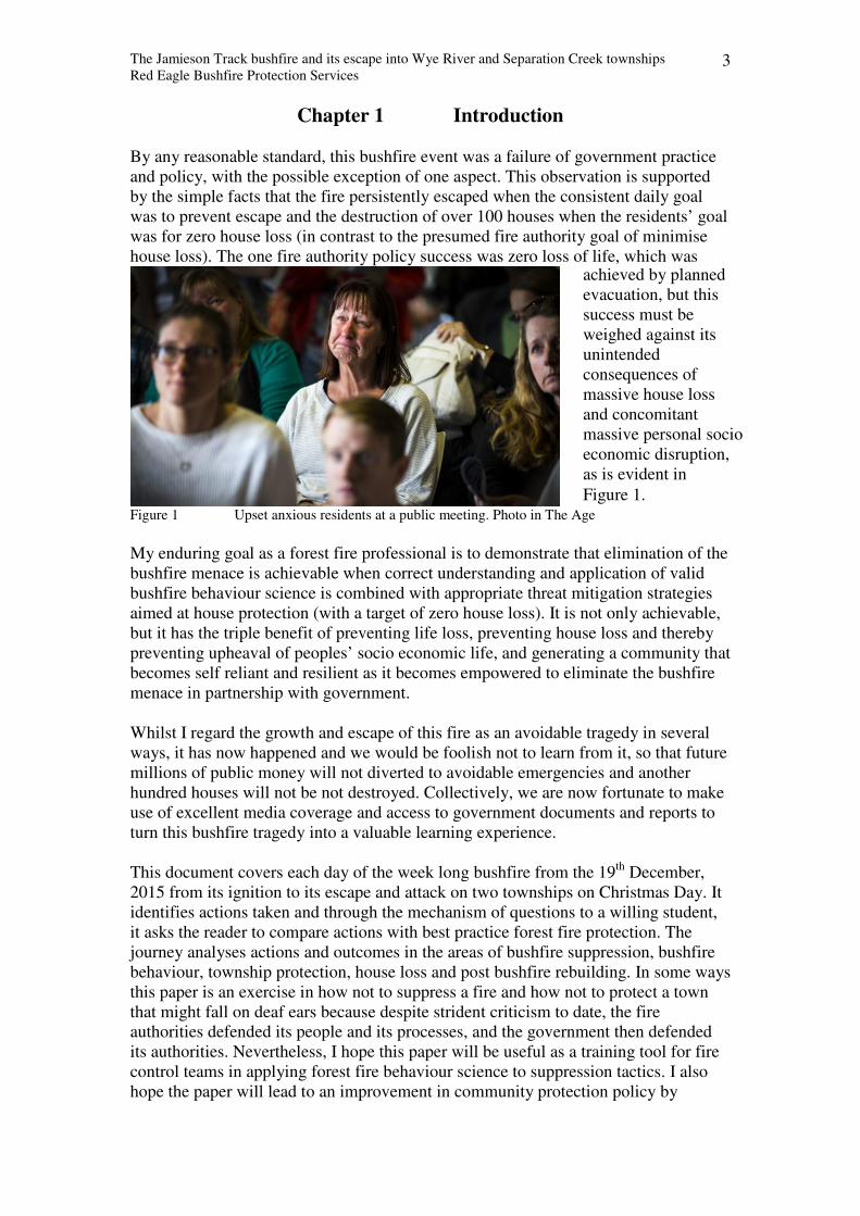
By any reasonable standard, this bushfire event was a failure of government practice
and policy, with the possible exception of one aspect. This observation is supported
by the simple facts that the fire persistently escaped when the consistent daily goal
was to prevent escape and the destruction of over 100 houses when the residents’ goal
was for zero house loss (in contrast to the presumed fire authority goal of minimise
house loss). The one fire authority policy success was zero loss of life, which was
Figure 1 Upset anxious residents at a public meeting. Photo in The Age
My enduring goal as a forest fire professional is to demonstrate that elimination of the
bushfire menace is achievable when correct understanding and application of valid
bushfire behaviour science is combined with appropriate threat mitigation strategies
aimed at house protection (with a target of zero house loss). It is not only achievable,
but it has the triple benefit of preventing life loss, preventing house loss and thereby
preventing upheaval of peoples’ socio economic life, and generating a community that
becomes self reliant and resilient as it becomes empowered to eliminate the bushfire
menace in partnership with government.
Whilst I regard the growth and escape of this fire as an avoidable tragedy in several
ways, it has now happened and we would be foolish not to learn from it, so that future
millions of public money will not diverted to avoidable emergencies and another
hundred houses will not be not destroyed. Collectively, we are now fortunate to make
use of excellent media coverage and access to government documents and reports to
turn this bushfire tragedy into a valuable learning experience.
This document covers each day of the week long bushfire from the 19th
December,
2015 from its ignition to its escape and attack on two townships on Christmas Day. It
identifies actions taken and through the mechanism of questions to a willing student,
it asks the reader to compare actions with best practice forest fire protection. The
journey analyses actions and outcomes in the areas of bushfire suppression, bushfire
behaviour, township protection, house loss and post bushfire rebuilding. In some ways
this paper is an exercise in how not to suppress a fire and how not to protect a town
that might fall on deaf ears because despite strident criticism to date, the fire
authorities defended its people and its processes, and the government then defended
its authorities. Nevertheless, I hope this paper will be useful as a training tool for fire
control teams in applying forest fire behaviour science to suppression tactics. I also
hope the paper will lead to an improvement in community protection policy by
achieved by planned
evacuation, but this
success must be
weighed against its
unintended
consequences of
massive house loss
and concomitant
massive personal socio
economic disruption,
as is evident in
Figure 1.
The Jamieson Track bushfire and its escape into Wye River and Separation Creek townships
Red Eagle Bushfire Protection Services 4
applying forest fire behaviour science in a way that provides effective bushfire
protection to all towns.
My keen interests are in studying forest fire behaviour and assessing the choice of fire
control tactics against principles of world best practice fire suppression and township
protection. The analysis also addresses how the homeless residents have now been
thrust into enforced acceptance of government policies of new house regulations,
despite a recent CSIRO report (and other data) which showed the regulations
conferred the same protection as non compliant houses. The examination indicates
that ineffectiveness of regulations is due to several distortions of science and logic
including (1) mitigating a negligible ignition threat (radiation) and doing so with the
use of invalid science and (2) enforcing the new house builder to pay extra to protect
against a deemed bushfire hazard that is itself never removed. I have attempted to
present appropriate data and observations in a dispassionate manner. I also try to
keep the paper readable and understandable to the non professional.
The student can assess the approach taken by authorities in the following events and compare
it to best practice.
The student should be alert to the rationale behind the following core events and assess his or
her approach to these and other issues:
• Each day, a fire control plan was set and reset, but each day, why were the objectives
never achieved, particularly on Day 1?
• Was the change of strategy from direct attack on a smaller fire area with Jamieson
Track as a fall back control line to indirect attack on a larger fire which made
Jamieson Track the last line of defence with no fall back line a serious error of
judgement? Was it exacerbated by adding fresh fire to the last line of defence two
days before severe weather?
• Was the possibility of the bushfire escaping seriously evaluated? Was the effect of
bushfire attack on the townships of Wye River and Separation Creek seriously
considered?
• The fire authorities enacted their full suite of available policy options for township
protection but why was the outcome a loss of over 100 houses?
• Their policy of evacuation was enacted.
• They provided aerial water bombing services to the townships but few ground
forces because it was declared as too dangerous for fire fighters to enter, even
though the average flame height was less than half a metre
• Were the fire authorities at fault by omission, by making decisions whereby:
• The townships of Wye River and Separation Creek were not protected externally
to prevent fire entry, or internally to prevent flame spread
• The boundary of National Park had no infrastructure to prevent fire escape.
• Why do the fire authorities now require that burnt houses be rebuilt at the highest
level of bushfire resistance, despite the fact that a third of houses built to the highest
level of fire resistance were destroyed when the forest flame was less than half a
metre tall?
During this journey of discovery, the student can consider the impact of policy influences on
bushfire suppression and town protection:
� Policy focus on a vague concept of risk management may prevent high level focus on
identifying real threats and mitigating the threats that cause most damage. Eg,
• In fire suppression, the real threat is failure of control line security
• In town protection, the real threats are entry of the moving flame and non
management of ember ignitions due to depletion of defender numbers
The Jamieson Track bushfire and its escape into Wye River and Separation Creek townships
Red Eagle Bushfire Protection Services 5
• In individual house protection, the real threats are non management of flame and
embers from any source, not artificial radiation from nearest vegetation.
� Policies that focus on protection of the individual house, namely the new house, may
prevent holistic community protection policy
� Policies with sole focus on protecting life may prevent the more efficacious policy of
protecting houses, because saving the house saves the house and the life, and house loss
disrupts peoples’ quality of life.
� Policies that focus on evacuation of people from an unprotected town may prevent
mitigation of hazards and threats and therefore prevent the town being protected
� Policies that focus on forcing the house owner to pay for self protection (new house and
retro fit) against a deemed threat may prevent mitigation of that threat
� Policies that avoid mitigation of each threat may prevent achievement of policy of
bushfire safe community
Source material
Most real time source data for this study was published in the daily Australian press
and on the fire authority web sites as the fire progressed. This has been supplemented
by subsequent government reports and studies. I have also included summaries of
interviews with local residents and fire fighters. Although I view the data through the
perspective of an experienced forest fire professional, I resist the temptation to
moralise or criticise. This is consistent with the educational purpose of this paper.
Government reports are useful provided we understand that they have a specific
purpose or meet specific terms of reference. Example 1 is the IGEM report. Its focus
was on how well the fire control team followed government policy and procedures
before the fire escaped, and had no interest or comment about how strategies and
actions complied with world best practice forest fire suppression. Example 2 is the
CSIRO report. It was commissioned by a fire authority to examine how the fire
entered the townships and why some houses burnt and some did not. It presents a
large amount of data but does not analyse all data because this task was not within the
terms of reference. Nevertheless, the data can be analysed independently.
The following Chapters present analyses of the six interrelated events in this bushfire
and when viewed as a whole, the range of topics covers most aspects of bushfire
protection planning and suppression relevant to a town. The events are suppression of
the bushfire, escape of the bushfire, bushfire behaviour on route to and within the
towns, preparation of the towns for a bushfire attack, house loss rate and finally the
rebuilding program. The issues for examination by the student are highlighted in
green, and the reader is also invited to consider them.
The Jamieson Track bushfire and its escape into Wye River and Separation Creek townships
Red Eagle Bushfire Protection Services 6
Chapter 2 Theories, Principles and Best Practice
Valid bushfire behaviour science
My starting position is that best practice fire suppression and township protection
cannot occur without application of valid bushfire behaviour science and that bushfire
behaviour science is only valid when it can be traced back to first principles of
scientific theory. For example (1) the fire authority belief that fuel load reduction
lowers the speed of the fire and that the reduction in speed protects the house derives
from invalid science. In contrast, valid science explains that fuel reduction on a given
site reduces flame height on that site, that lower flame height produces lower heat flux
(via radiation, convection and advection), that increasing separation distance reduces
heat flux further, and that reducing the heat flux is what protects the house. (2) The
fire authority belief that rate of spread of the fire can be used to predict flame height
derives from invalid science. In contrast, valid science shows that in wind driven fires
there may be a loose coincidental connection (eg, Project Vesta, 2007), but there is no
logical or causal correlation between rate of spread, which is a dependent variable that
derives from independent variables including fuel particle size, fuel bed aeration and
wind speed and flame height which is a dependent variable deriving from independent
variables including fuel particle size and fuel bed height Moreover, a useful rule of
science is that dependent variables should always derive from independent variables.
Best practice forest fire suppression
Based on a lifetime of training, experience, observation and study, I can pragmatically
summarise best practice forest fire suppression as reducing the chance of a bushfire
escaping from a designated control line by the application of strategies, tactics and
resources guided by proven principles and experience. Proof of best practice
suppression is when the bushfire attack stops at the designated control line with
minimum outlay of resources and expenditure.
Implicit in the definition is a strong goal that is quantifiable and achievable on the fire
ground by adequate committed resources within a nominated period. The definition
recognises that forest fire fighting is a perimeter exercise whose progress is measured
by length of mineral earth control line against length of fire perimeter, and logically
the fire is controlled when control line length equals fire perimeter and is secured to
prevent flame and ember escape.
Best practice therefore requires adequate resourcing for each stage of the fire
suppression process - control line construction, securing the line by blacking out, and
patrolling. Control line strategy includes a fall back control line strategy. Line
construction by water bombing must be secured with a mineral earth break and
patrolling because its effect on a forest flame is ephemeral.
Best practice aims to keep the fire area small by direct attack, particularly when fire is
close to settlements or when fire occurs early in fire season or when severe weather in
imminent. Because forest fire suppression by direct attack in the heat of the day is
impossible unless the flame height is low and access is safe, it is done when weather
moderates, usually overnight.
Best practice forest fire suppression requires a back-burn or burn-out strategy to have
a minimum depth of blacked out forest upwind of a good track to stop the flame and
The Jamieson Track bushfire and its escape into Wye River and Separation Creek townships
Red Eagle Bushfire Protection Services 7
to absorb some of the short distance spotting. It also requires appropriate resourcing
and infrastructure to prevent escape of spot fires that ignite downwind.
Best practice township protection
Based on a lifetime of experience, observation and study, I can summarise best
practice township protection as reducing the chance of house loss by a bushfire attack
in a nominated area by the application strategies, tactics and resources guided by
proven principles and experience. Proof of best practice township protection is when
the bushfire attack on a nominated area results in zero house loss.
Implicit in the definition is the goal of house protection rather than life protection
because houses are static whereas people can move out of danger. It is self evident
that when the house is properly protected, the surrounds are safe for the resident and
the fire fighter alike to remain during the bushfire attack.
Thus best practice township protection prevents entry of the most dangerous part of
the bushfire, ie, the advancing flame, by strategic combination of low flame and no
flame zones, prevents internal spread by fuel bed discontinuity, and creates a safe
environment to manage ember attack by facilitating suppression of spot fires while
small within the township.
Causes and prevention of house loss in severe bushfire attack
I can summarise a large body of research as follows. In a bushfire attack, the known
causal agents that can ignite a building are flame contact, radiant heat, and ember
attack. For ignition of building material to occur by the first two causes, the flame
must to be close to the building but ember attack typically occurs when the flame is at
a distance. To prevent ignition, there are two techniques – passive or static protection
and active protection.
(1) To provide passive protection against ignition by the first two agents, the
flame’s proximity, size and separation distance can be managed or the fire resistance
of the exposed building material can be increased. To prevent ignition of the building
by embers requires specific treatment of the building against the expected size and
intensity of the ember.
(2) Active protection against ignition of the building is typically done with water
or foam spray onto the surface, the aim of which is to keep temperature and oxygen
supply below ignition point. Active protection can also be direct - against the flame of
the attacking bushfire and the flame of a spot fire, or indirect - wetting the adjacent
fuel bed to make it non flammable and thereby prevent lateral flame spread. Active
protection by people requires the defence area to be rendered bushfire safe which is
done by strategically managing fuel bed discontinuity.
Passive protection policy is effective when it causes substantial decline in house loss
rate when its measures are deployed. Prior to 2009, the fire authorities operated two
policies for protection of new houses. The WMO system was based on the width of
defendable space from the nearest forest that was deemed to have a large radiating
flame, and the AS3959 system was based on a higher fire resistance level of building
materials if the house was located closer to the nearest forest that was deemed to have
a large radiating flame. The VBRC asked for evidence that the WMO and AS3959
reduced house loss, and was told there was none (VBRC, 2010). However, evidence
The Jamieson Track bushfire and its escape into Wye River and Separation Creek townships
Red Eagle Bushfire Protection Services 8
was presented by the Building Commission and Shires that confirmed that neither
policy had a significant impact on reducing house loss rate.
Example (1) Of the 5,375 houses within the fires’ perimeters, 2118 were destroyed
(Leonard et al, 2009). Using data from reports submitted to the VBRC (Buxton et al,
2009 and Leonard et al, 2009), the estimated proportion of AS3959 compliant houses
at the time of the bushfire was between 8 and 12%, average 10% or 537 houses. The
Victorian Building Commission advised the VBRC that of 2006 destroyed houses,
177 were AS3959 compliant, ie, were built higher fire resistance. Thus the house loss
rate for compliant houses averaged 33% (= 177 / 537), which is rather close to the
38% house loss rate for non compliant houses (= [(2006-177) / (5375-537)].
Example (2) Marysville town data (provided by the Shire) showed that of over 400
houses, the total house loss rate was 90%. It also showed that 26 dwellings were built
with WMO permits, and 22 of them were destroyed. Thus, the house loss rate for
WMO compliant houses was 85%, which is imperceptibly better than the overall loss
rate (Referenced in Bushfire Solution Paper 6A).
Warning note: There was one unexpected and worrying loss rate within the VBRC
data. Life loss rate (measured as percentage of houses with bodies) was three times
higher in compliant houses (7.3%) that non compliant (2.5%). Indeed evidence taken
by the VBRC supported the view that people saw compliant houses as safer and
sought shelter in them (Referenced in Bushfire Solution Paper 6B).
Despite the above evidence and other strident criticisms, the VBRC recommended a
review, but the fire authorities adopted an amended AS3959 in 2009 and in the
following year, amalgamated the two into one BMO system.
Active protection policy is effective when it results in a substantial decline in house
loss rate when houses are actively defended. Before the VBRC in 2009, defensive
suppression of a house by residents or fire fighters (ie, active defence during or
shortly after bushfire attack) had long been known as the most influential factor in
reducing house loss during a bushfire attack. A study of the Ash Wednesday fire at
Macedon (Wilson and Ferguson, 1984) found the house loss rate of “vacant,
undefended houses” was 65%, the house loss rate for occupied houses was 18% and
the house loss rate for houses actively defended by able-bodied people was 10%. A
later study based on post-bushfire surveys found if houses are not attended, house
losses are 3 to 6 times greater than attended houses (Blanchi & Leonard 2008b). This
outcome was independent of their fire resistance level.
Data collected during the VBRC also confirmed that active defence yielded a
substantially lower house loss rate than vacated houses, but it is unlikely the VBRC
saw this data before its final report date. For example, Whitaker et al reported these
findings in 2013 from their survey:
• Of the 766 houses that were occupied and defended, the house loss rate was
19% [house loss rate was two in ten houses.]
• Of the 498 undefended houses, the house loss rate was 54% [house loss rate
was five in ten houses.]
Where extra help was available to the defenders (eg, from family, friends, neighbours,
fire agencies), the house loss rate was even lower.
• Where helped by other people, house loss rate was 1 in 10
• Where helped by fire services, house loss rate was 0.3 in 10, or 3 in 100.
The Jamieson Track bushfire and its escape into Wye River and Separation Creek townships
Red Eagle Bushfire Protection Services 9
Despite such consistent evidence, the VBRC was unmoved. Faced with the bushfires’
huge death toll and the VBRC’s strong mantra that human life must be protected as
first priority, the VBRC report indicated it lost faith in the ability of residents to self
defend and recommended in favour of a pro-evacuation policy, which the government
immediately adopted. This recommendation was made despite awareness of the above
research and despite evidence about the downstream consequences of evacuation, in
particular, the negative effects of house loss on the quality of life of the resident and
on other socio economic consequences.
Wind the clock forward to now, the two passive protection policies used by the fire
authorities that had no influence on reducing house loss rate of policy-credentialed
new houses, have now been amalgamated, and active protection is discouraged by the
fire authorities despite the consistent data that it results in substantial house loss rate.
Their policy is to strongly encourage evacuation and discourage self defence.
The Jamieson Track bushfire and its escape into Wye River and Separation Creek townships
Red Eagle Bushfire Protection Services 10
Chapter 3 The bushfire grows and escapes
Day 1 Saturday, 19 December, 2015
This day was a Total Fire Ban (TFB) day for the whole state, with northerly winds.
Historically, TFB days are declared for specific areas when forecast Fire Danger
Index is around 50 or above. It generally means if a fire ignites, it will grow rapidly
and be difficult to control. The CFA web site confirmed that the previous day was a
TFB in this region, the following day was a TFB for the whole state and Christmas
Day was a TFB in this region.
In the afternoon, lightning storms ignited two fires in the Otway Ranges. One was 1.2
km from Jamieson Track. (The other was several kilometres inland and was
controlled within a few days.) The first report of the Jamieson Track fire was in the
Sit Rep (Situation Reports, 2016) at 16.10, when it was reported as 0.5 ha with
moderate spread potential. Initially, a six person ground crew and a reconnaissance
aircraft were despatched.
The final Sit Rep for the day at 20.39 reported that a dozer track had almost been built
to the fire edge, that a helitack had dumped water onto it and that the fire size was
1ha. A fire of this area has an estimated perimeter of approx 0.4 km. The fire control
plan was to construct a mineral earth line around perimeter, patrol and then mop up
overnight. Control was expected by midday tomorrow. The Sit Rep mentioned (1) a
night crew of 9 people will monitor the fire edge, and (2) the forecast for tomorrow is
difficult weather, but the controllers would have been aware that a TFB had been
declared.
The IGEM investigation report was a little confusing. It said the dozer continued
working till 1am, but said that night crews did no containment work on the fire edge
after dusk and overnight. Because the access track into the fire was almost completed
by 8.39pm, this suggests the dozer may have started work on the fire edge without
ground crew help. It was unclear about actual overnight crew numbers at the Jamieson
Track fire were uncertain. It confirmed that large numbers of CFA fire fighters were
stood down before nightfall. (Direct quotes from IGEM report are in blue) • The crew continued to work on the containment line until light failed. For safety reasons the
crew was withdrawn to the dozer track at this time, but maintained a watch on the fire
overnight.
• The dozer was able to work until approximately 1am on 20 December, when it encountered
steeper terrain.
• The night crew of 10 personnel was shared across the two fires.
• CFA responded on 19 December with 27 personnel and 9 tankers. These crews were stood
down at 6.40pm on this date as the terrain was inaccessible for the tankers. CFA returned on
the afternoon of 22 December to support the back-burn operations.
Thus the clear conclusion from the evidence to date is that the fire edge was not
contained by the overnight crews because they were not deployed to do so.
Best practice fire suppression requires that a small fire is rapidly contained and made
safe overnight before difficult weather the following day. This calls for an aggressive
suppression effort by adequate committed crews overnight. To me as a forest fire
professional, a hand constructed perimeter around a fire edge of approx 400m should
The Jamieson Track bushfire and its escape into Wye River and Separation Creek townships
Red Eagle Bushfire Protection Services 11
have been achieved with on site resources, and would have been secured if a relief
crew and large dozers arrived in early morning.
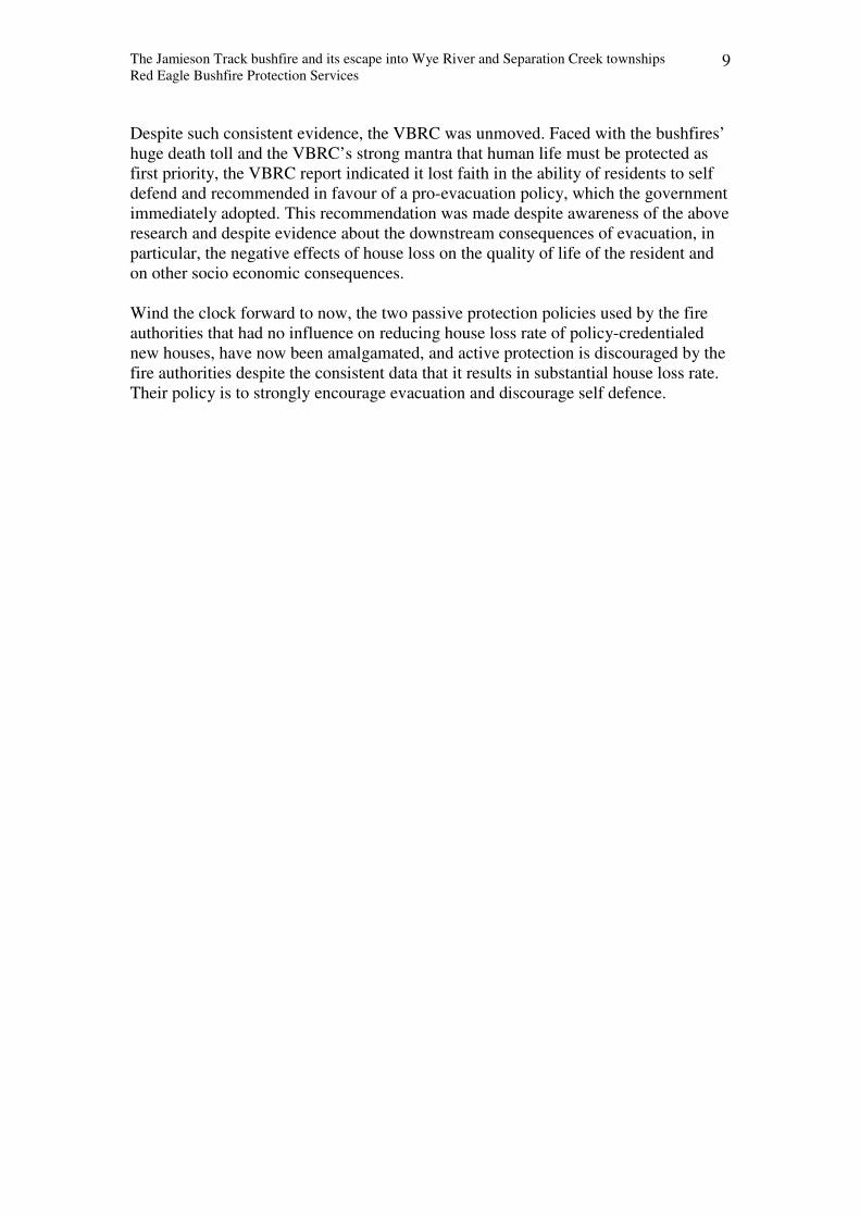
Figure 2 Shows approximate location of fire origin at 4 pm on 19 December 2015. White
dashed arrow is approx path of initial dozer track along ridgeline. Yellow outlines approx scorched
areas caused during fire escapes in the westerlies on Day 2. Green arrow is approx location of
subsequent dozer track, presumably installed to access yellow areas after Day 2. Red outlines approx
fire boundary on Day 4 after escape up the steep slope to Jamieson Track.
The student can assess whether the overnight non-deployment was consistent with best
practice fire suppression, whether the fire control plan was achievable overnight with
allocated resources, and whether the lack of action overnight minimised the chance of fire
escape on the following day. The student can assess why the stated fire control plan of
rounding the fire up overnight was not achieved with the combination of strategy and actions.
In particular, was the construction and securing of a hand made control line of some 400m
achievable overnight in safety with the available resources, or could it have been achieved
with additional or appropriately equipped resources? For the latter question, what resources
were required, were they available, why were they not deployed to achieve the overnight
target?
Day 2 Sunday 20 December, 2015
This day was declared a TFB for the whole state, with westerly winds on the fire
ground.
The Sit Rep of 7.22 am reported that 80% of the fire edge was untracked. The fire
area was still only 1 ha. This confirms the IGEM statement about no action on the fire
edge overnight. The expected time of control was midday today.
The Sit Rep of 10.25 reported the fire was 20 ha, and two dozers were working on the
edge. They now needed to construct 2 km of perimeter track. The expected time of
control was changed to 10 pm today.
1 km
N Jamieson Tk
Godfrey Tk
The Jamieson Track bushfire and its escape into Wye River and Separation Creek townships
Red Eagle Bushfire Protection Services 12
The Sit Rep of 12.37 reported a fire area of 28 ha, and the 15.36 one reported 65ha,
with respective perimeters of 4 km and 6km. The 15.36 Sit Rep reported that 2 km of
control line had been constructed. It also reported that light rain began to fall. The
final Sit Rep at 19.40 reported a fire area of 65ha, 2km of constructed control line and
a total live perimeter of 6km, and the strategy was direct attack, ie, construct a control
line along the fire perimeter. The expected time of control was changed to 10 pm on
the next day.
Whilst it is clear that two successive fire control plans failed to achieve their targets
today, the reasons are not clear. The IGEM report adds to confusion by stating that (1)
personnel numbers were increased to 14 and dozers to three, (2) that terrain slowed
line construction rate and (3) that terrain prevented deployment of more resources.
The forest fire professional regards 14 personnel as under resourced if the hand crew
construction rates are slow. If three large dozers were deployed on line construction in
this steep terrain, four km of control line should have been cut within a few hours and
these lines would need to be patrolled by more slip ons and tanker crews than had
been allocated. The concept of terrain preventing additional resources can be rejected
as nonsense, particularly because the resource allocations in the following days were
well above today’s. The fire professional finds it incongruous that such a large fleet of
water bombers could not prevent expansion of the perimeter before the rain fell.
Relevant IGEM quotes were: • Firefighting resources were increased to 14 and 8 personnel (day and swing shift
respectively), one tanker, four slip on units, and three dozers. The terrain precluded more
resources being deployed.
• One crew was only able to cut 140 m of containment line by hand in a day.
• Construction of bare earth containment lines continued during 20 December. On-ground
resources were also increased, with three dozers, and 30 firefighters (8 night crew were shared
across the 2 fires). Of the six kilometres fire perimeter, crews had established two kilometres
of containment by late on 20 December.
• At 6.58am on 20 December the IMT requested aircraft at the fire ground as soon as possible.
The medium helitack and support aircraft were airborne at 7.24am. At 8.23am further aircraft
were requested as the fire had broken the containment lines and was growing rapidly. The
aerial response was strengthened between 9am and 1.30pm with a total of 7 firefighting (as
opposed to observing) aircraft including 4 water bombers (2 large air tanker and 2 smaller
tankers) and 3 helitacks (2 medium, one large).
Best practice forest fire suppression suggests that lulls in expansion rate of fire
perimeter should be taken advantage of by maintaining or increasing line construction
rate.
The student can assess whether the failure to achieve two fire control plans was due to under
allocation of resources, misallocation of resources or other reasons. The student can assess
why the total line construction rate by three dozers for the whole day was 2km, a zero
increase since the 15.36 Sit Rep. Eg, was it because they were not allocated to line
construction or because the terrain was too difficult?
Day 3 Monday 21 December, 2015
Mild weather
The Sit Rep of 11.03 am reported the fire area was 86 ha, the total perimeter was 7km,
and 2km of control line had been built. Control was expected by 10pm tonight. The
The Jamieson Track bushfire and its escape into Wye River and Separation Creek townships
Red Eagle Bushfire Protection Services 13
focus of the plan was to complete the remaining 5 km of control line. The number of
personnel on the fire ground was deduced as 40 (70 total less 30 in control HQ at
Colac), and either 3 or 4 dozers. The final Sit Rep at 22.31 quoted a fire area of 92 ha,
a live perimeter of 8km and 2 km of completed control line. Sit Reps report spot fire
activity during the day. One grew to 3 ha.
The IGEM report wording implied productive work occurred on the fire edge today
when no additional control line was built: Milder conditions allowed firefighters to
continue building containment lines. Crews had established 2 km of containment line on the fire’s 7 km
perimeter.
Best practice forest fire suppression suggests the remaining 5 km of control line
would have been constructed as the highest priority today so that it was made secure
before Friday the 25th
.
The student can assess why no additional fire line was constructed today, despite at least 3
dozers on site. Eg, was it because they were not allocated to line construction or because the
terrain was too difficult or other reasons?
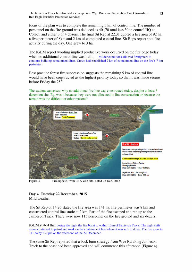
Figure 3 Fire update, from CFA web site, dated 23 Dec, 2015
Day 4 Tuesday 22 December, 2015
Mild weather
The Sit Rep of 14.26 stated the fire area was 141 ha, fire perimeter was 8 km and
constructed control line static at 2 km. Part of the fire escaped and ran up to the
Jamieson Track. There were now 113 personnel on the fire ground and six dozers.
IGEM stated that during the night the fire burnt to within 10 m of Jamieson Track. The night shift
crews continued to patrol and work on the containment line where it was safe to do so. The fire grew to
141 ha by 2.26pm on the afternoon of the 22 December.
The same Sit Rep reported that a back burn strategy from Wye Rd along Jamieson
Track to the coast had been approved and will commence this afternoon (Figure 4).
The Jamieson Track bushfire and its escape into Wye River and Separation Creek townships
Red Eagle Bushfire Protection Services 14
IGEM stated: The IC, together with team leaders of the IMT, identified Option 4 (the back-burn
option) as the approach that had the greatest chance of succeeding in containing the fire.
The Sit Rep stated: “Consequence of failure in relation to current strategy is a
much larger fire and potential threat to assets longer term”. IGEM restated this as
follows: Incident planners had identified a much larger fire and risk to assets as the
consequence of the back-burn strategy failing. The IGEM added: Reflecting these significant
consequence and their significant implications for communities, the IC initiated planning for
community engagement and safety strategies for communities to the north, and south of the fire, and
for the Great Ocean Road.
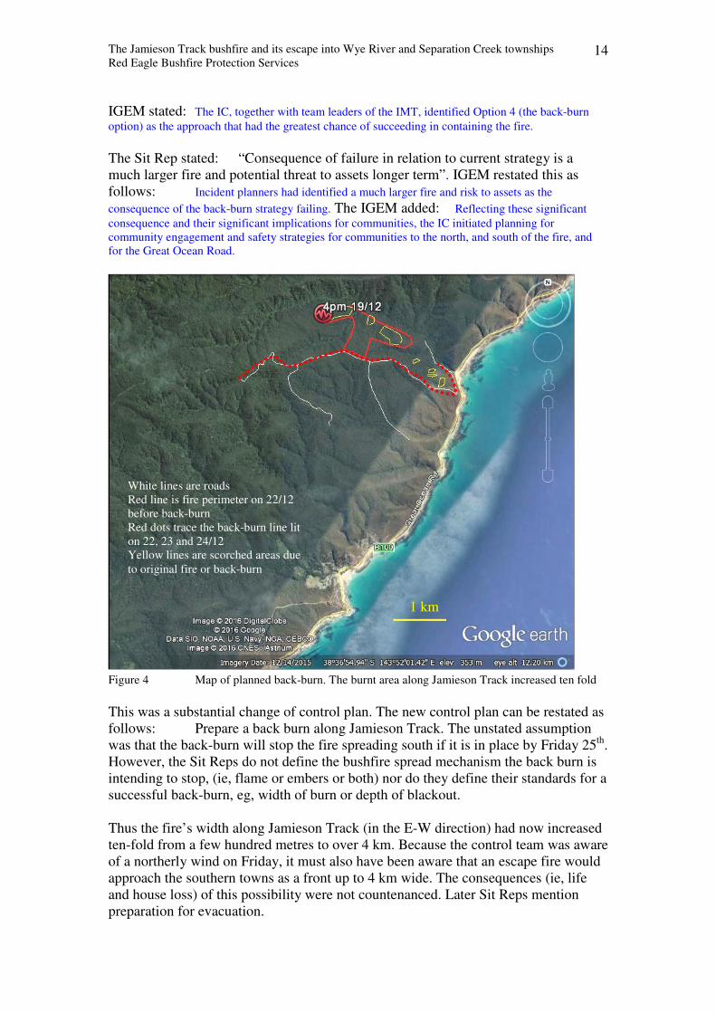
Figure 4 Map of planned back-burn. The burnt area along Jamieson Track increased ten fold
This was a substantial change of control plan. The new control plan can be restated as
follows: Prepare a back burn along Jamieson Track. The unstated assumption
was that the back-burn will stop the fire spreading south if it is in place by Friday 25th
.
However, the Sit Reps do not define the bushfire spread mechanism the back burn is
intending to stop, (ie, flame or embers or both) nor do they define their standards for a
successful back-burn, eg, width of burn or depth of blackout.
Thus the fire’s width along Jamieson Track (in the E-W direction) had now increased
ten-fold from a few hundred metres to over 4 km. Because the control team was aware
of a northerly wind on Friday, it must also have been aware that an escape fire would
approach the southern towns as a front up to 4 km wide. The consequences (ie, life
and house loss) of this possibility were not countenanced. Later Sit Reps mention
preparation for evacuation.
White lines are roads
Red line is fire perimeter on 22/12
before back-burn
Red dots trace the back-burn line lit
on 22, 23 and 24/12
Yellow lines are scorched areas due
to original fire or back-burn
1 km
The Jamieson Track bushfire and its escape into Wye River and Separation Creek townships
Red Eagle Bushfire Protection Services 15
IGEM stated: The IC anticipated the favourable conditions would last until the night of 23
December, providing two days for the back-burn operation. The IC was aware that temperatures were
expected to increase and winds to strengthen later in the week.
Thus the IGEM appears to uncritically accept the control team’s assumption that a
summer burnout in a forest is like a burning a patch of grass – once the burn has been
done, everything is black and non flammable. Yet in reality, forest fires retain
hundreds of hot spots in the ground, in stumps, in logs, in trunks and in upper
branches that smoulder for days that come to life when winds increase.
The change of strategy from moderate cost / moderate level resources to high cost /
high level resources seems to have changed the focus of the control team. Instead of a
focus on preventing the spread of the original fire, it now became a focus on how well
the new burn was progressing. The goal of stopping the fire’s spread by the tactic of
back-burning was superseded by the goal of achieving a good back-burn. Thus the
tactic became the goal, and the quality of the burn became the measure of success.
The IGEM appears to have adopted a similar mindset. This is indicated by an absence
of criticism when reporting the fire escape. The scrutiny of whether and how the
back-burn will actually stop fire spread to the south was not obvious.
This IGEM report indicated acceptance of the new strategy: The window of opportunity for
back-burning was favourable, The required containment lines were in place and back-burning offered
the greatest potential to reduce the risk to communities and assets.
The 17.55 Sit Rep reported the fire area at 180 ha, fire perimeter 11.5 km and even
though only 2km of control line had been constructed, there was 6 km of control line
to be built. The extra area was due to the back burn operations. There were now 178
personnel on the fire ground and an additional 20 CFA fire fighters. The number of
resources on line contradicts the IGEM’s earlier statement above that The terrain
precluded more resources being deployed.
The Sit Rep summarised burn depths and the IGEM paraphrased it as follows: By
late 22 December, reports indicate that the back-burn was progressing well, with flame heights of 1–1.5
m. Crews were achieving between 10 and 30 m depth in the western sector, and 50 to 100 m in the
eastern sector
The student can assess whether the IGEM’s uncritical acceptance of the Sit Rep statements of
success was appropriate. In particular, can an independent audit technically adopt the label of
success when the results cannot be compared against the targets? Eg, If the standard of
success is a blacked out depth of 75 m, any depth less than this is a failure, no matter how hot
the fire or how tall the flame.
Best practice forest fire suppression suggests the original control plan target of 6 km
of control line would have been constructed as the highest priority so that it was made
secure before Friday the 25th
. The decision to change the strategy from direct attack to
indirect by back-burning two days before a severe weather day and a few days after
two consecutive severe weather days in dry remote forest is not consistent with best
practice. Adding fresh fire in forest along the last line of defence two days before a
severe weather day is best practice only when the downwind area has highly
discontinuous surface fuel bed, a high level of vehicle access and a high level of well
trained defenders. These conditions did not occur south of Jamieson Track.
The Jamieson Track bushfire and its escape into Wye River and Separation Creek townships
Red Eagle Bushfire Protection Services 16
The student can assess why no additional fire line was constructed today, despite the presence
of at least 3 dozers. The student can calculate what depth of blacked out area will be required
to prevent flame spread across Jamieson Track, and what depth is required to prevent spread
by embers. They can also consider that whereas Jamieson Track was a useful fall back control
line when the fire control plan was direct attack, the choice of Jamieson track as the burn-out
line made it the last line of defence because there was no prepared fall back line in the south.
The student can consider whether a narrow freshly burnt strip of forest can harbour
smouldering embers for two days and thereby become a source of spreading embers, or
whether it will be wide enough to capture all embers generated upwind. If the possibility
exists that the burnt area cannot prevent spread by embers from the last line of defence, what
strategies can be enacted to prevent fire spread to the south on Friday 25th? Were they
implemented?
[The IGEM commented: Crews undertook work to assess contingency containment lines to
the south of the fire on 22 December. Reports indicate works to cut the lines were scheduled, but do not
confirm their completion.]
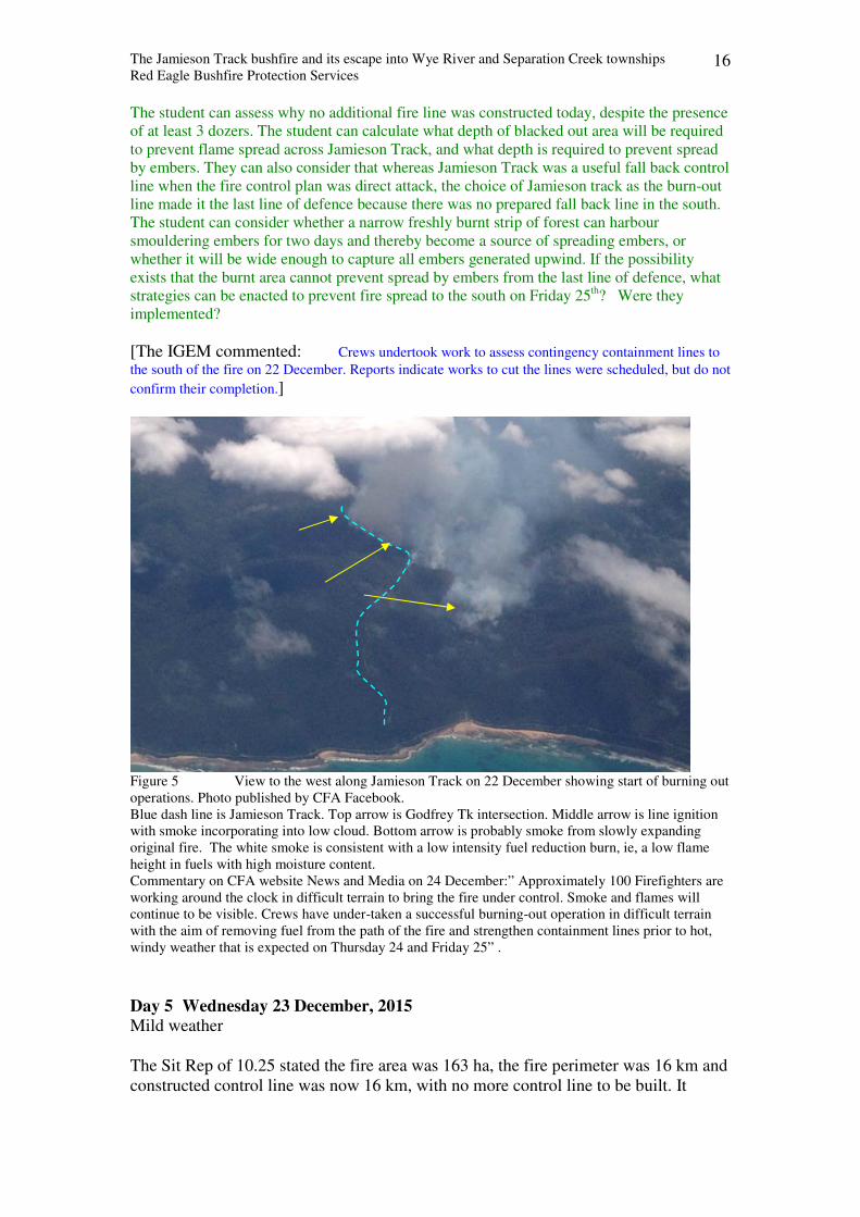
Figure 5 View to the west along Jamieson Track on 22 December showing start of burning out
operations. Photo published by CFA Facebook.
Blue dash line is Jamieson Track. Top arrow is Godfrey Tk intersection. Middle arrow is line ignition
with smoke incorporating into low cloud. Bottom arrow is probably smoke from slowly expanding
original fire. The white smoke is consistent with a low intensity fuel reduction burn, ie, a low flame
height in fuels with high moisture content.
Commentary on CFA website News and Media on 24 December:” Approximately 100 Firefighters are
working around the clock in difficult terrain to bring the fire under control. Smoke and flames will
continue to be visible. Crews have under-taken a successful burning-out operation in difficult terrain
with the aim of removing fuel from the path of the fire and strengthen containment lines prior to hot,
windy weather that is expected on Thursday 24 and Friday 25” .
Day 5 Wednesday 23 December, 2015
Mild weather
The Sit Rep of 10.25 stated the fire area was 163 ha, the fire perimeter was 16 km and
constructed control line was now 16 km, with no more control line to be built. It
The Jamieson Track bushfire and its escape into Wye River and Separation Creek townships
Red Eagle Bushfire Protection Services 17
reported good depth of burn along Jamieson Tk. It also mentions resources for fall
back lines have been requested, but not yet provided. Control was expected by 18.00
on 26 December. There were 70 personnel on the fire ground. The Sit Reps of 13.07,
16.04 and 22.55 report fire areas of 254, 246 and 246 ha respectively, and total
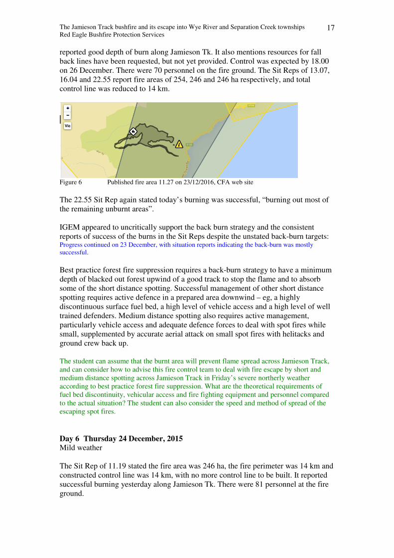
control line was reduced to 14 km.
Figure 6 Published fire area 11.27 on 23/12/2016, CFA web site
The 22.55 Sit Rep again stated today’s burning was successful, “burning out most of
the remaining unburnt areas”.
IGEM appeared to uncritically support the back burn strategy and the consistent
reports of success of the burns in the Sit Reps despite the unstated back-burn targets: Progress continued on 23 December, with situation reports indicating the back-burn was mostly
successful.
Best practice forest fire suppression requires a back-burn strategy to have a minimum
depth of blacked out forest upwind of a good track to stop the flame and to absorb
some of the short distance spotting. Successful management of other short distance
spotting requires active defence in a prepared area downwind – eg, a highly
discontinuous surface fuel bed, a high level of vehicle access and a high level of well
trained defenders. Medium distance spotting also requires active management,
particularly vehicle access and adequate defence forces to deal with spot fires while
small, supplemented by accurate aerial attack on small spot fires with helitacks and
ground crew back up.
The student can assume that the burnt area will prevent flame spread across Jamieson Track,
and can consider how to advise this fire control team to deal with fire escape by short and
medium distance spotting across Jamieson Track in Friday’s severe northerly weather
according to best practice forest fire suppression. What are the theoretical requirements of
fuel bed discontinuity, vehicular access and fire fighting equipment and personnel compared
to the actual situation? The student can also consider the speed and method of spread of the
escaping spot fires.
Day 6 Thursday 24 December, 2015
Mild weather
The Sit Rep of 11.19 stated the fire area was 246 ha, the fire perimeter was 14 km and
constructed control line was 14 km, with no more control line to be built. It reported
successful burning yesterday along Jamieson Tk. There were 81 personnel at the fire
ground.

The Jamieson Track bushfire and its escape into Wye River and Separation Creek townships
Red Eagle Bushfire Protection Services 18
The Sit Rep of 22.49 stated the fire area was 271 ha, the fire perimeter was 14 km and
13 km was completed with 1 km to be completed. It again reported successful burning
yesterday along Jamieson Tk. There were 81 personnel at the fire ground. The Sit Rep
at 0.27 on 25 December said there were 37 personnel on the fire ground.
The IGEM report uncritically corroborated the Sit Rep statements and endorsed the
back-burn strategy as a success: • Reports from 24 December indicate the fire was quiet throughout the day, and remained
within the existing containment lines. By 24 December, crews were finalising the back burn.
• The IC was satisfied that the burns conducted over the previous days had been successful.
Crews continued to patrol the fire edge, and black out fire along Jamieson Track.
• Reports indicate the back-burn progressed as planned, implementing the strategy of protecting
against fire spreading with northerly winds forecast for 25 December
• This strategy was successful in reducing fuels and potential fire intensity (infrared mapping
had previously identified 1000 hot spots in the original fire).
• With the back-burn providing protection against spread of the fire to the south, crews prepared
containment lines on the northern side in preparation for a wind change expected for late on
25 December.
The test for the IGEM’s endorsement will come tomorrow. Will it achieve its
purpose, and help prevent fire escape in a strong N wind?
The student can compare these remarkably positive comments with those of local firefighters
who worked on blacking out Jamieson Track this evening. They advised me of their great
concern of an escape because of the amount of roostering they saw across the track. By
roostering, they meant sprays of live embers from hot spots in the ground and in trees.
Day 7 Thursday 25 December, 2015
Severe weather, strong wind from north.
The Sit Rep of 5.33 am stated the fire area was 271 ha, the fire perimeter was 14 km
and constructed control line was 13.2 km, with 0.8km of control line to be built. It
again reported successful burning yesterday along Jamieson Tk. There were 37
personnel and 8 slip on units and 1 tanker at the fire ground. The control plan was
“direct attack to contain within current boundaries and continue to patrol and
blackout”.
The student can assess how realistic this control plan was and how well resourced it was.
Does the plan recognise spotting across the line and thereby deploy adequate resources on
ground and in air to deal with spot fires? Can the student explain why aircraft were not
mentioned in the resources list?
The IGEM also reported 37 personnel on line, but the experienced bushfire
professional regards the list as an editing failure, perhaps due to pressure in the
control centre because the resources table remained unchanged throughout the day
until after 10 pm. However, if the resources figure is accurate, it is sadly inconsistent
with best practice forest suppression.
The student can readily calculate that 37 people over 4 km of patrol line is approx 10 per km,
and can compare it to the desirable resources ratio required on a last line of defence with fresh
forest fire alongside.
The Jamieson Track bushfire and its escape into Wye River and Separation Creek townships
Red Eagle Bushfire Protection Services 19
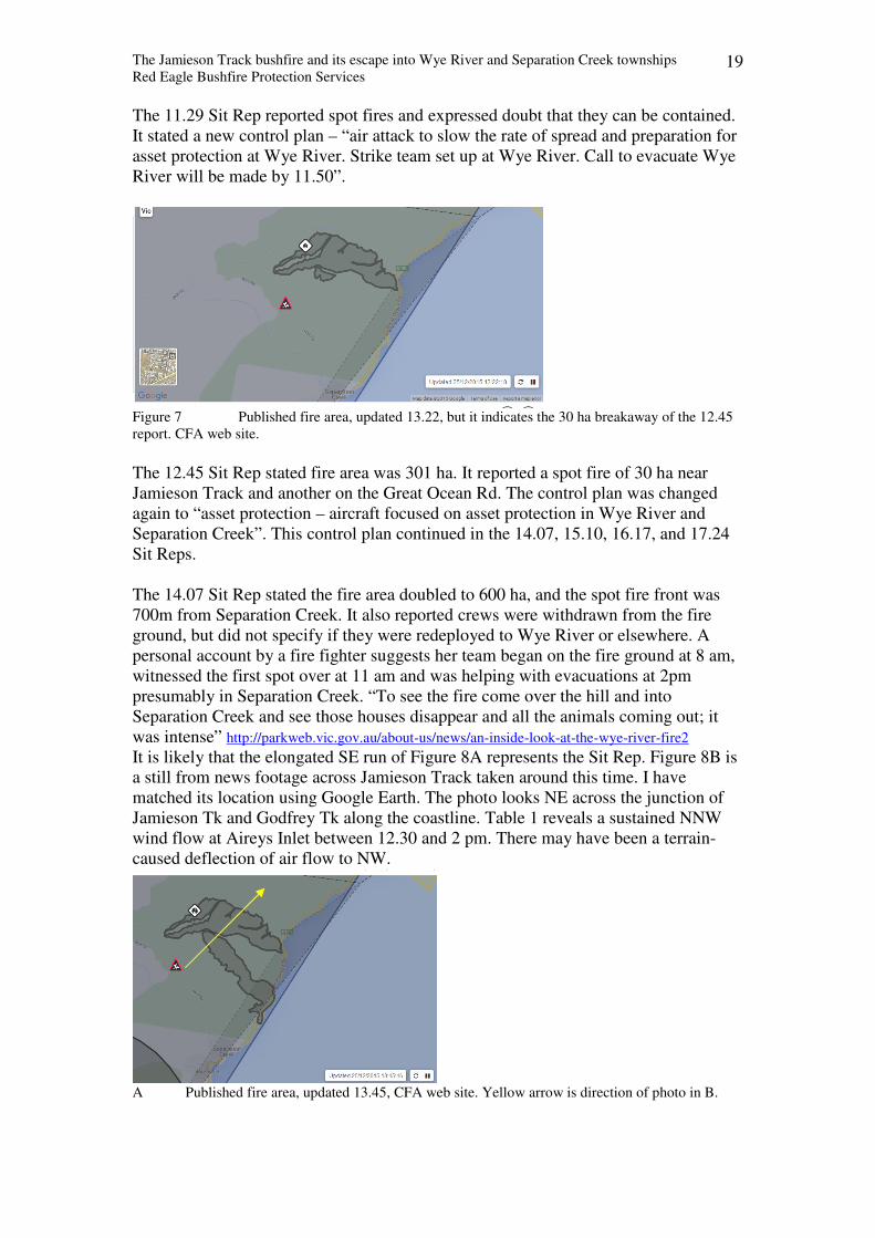
The 11.29 Sit Rep reported spot fires and expressed doubt that they can be contained.
It stated a new control plan – “air attack to slow the rate of spread and preparation for
asset protection at Wye River. Strike team set up at Wye River. Call to evacuate Wye
River will be made by 11.50”.
Figure 7 Published fire area, updated 13.22, but it indicates the 30 ha breakaway of the 12.45
report. CFA web site.
The 12.45 Sit Rep stated fire area was 301 ha. It reported a spot fire of 30 ha near
Jamieson Track and another on the Great Ocean Rd. The control plan was changed
again to “asset protection – aircraft focused on asset protection in Wye River and
Separation Creek”. This control plan continued in the 14.07, 15.10, 16.17, and 17.24
Sit Reps.
The 14.07 Sit Rep stated the fire area doubled to 600 ha, and the spot fire front was
700m from Separation Creek. It also reported crews were withdrawn from the fire
ground, but did not specify if they were redeployed to Wye River or elsewhere. A
personal account by a fire fighter suggests her team began on the fire ground at 8 am,
witnessed the first spot over at 11 am and was helping with evacuations at 2pm
presumably in Separation Creek. “To see the fire come over the hill and into
Separation Creek and see those houses disappear and all the animals coming out; it
was intense” http://parkweb.vic.gov.au/about-us/news/an-inside-look-at-the-wye-river-fire2
It is likely that the elongated SE run of Figure 8A represents the Sit Rep. Figure 8B is
a still from news footage across Jamieson Track taken around this time. I have
matched its location using Google Earth. The photo looks NE across the junction of
Jamieson Tk and Godfrey Tk along the coastline. Table 1 reveals a sustained NNW
wind flow at Aireys Inlet between 12.30 and 2 pm. There may have been a terrain-
caused deflection of air flow to NW.
A Published fire area, updated 13.45, CFA web site. Yellow arrow is direction of photo in B.
The Jamieson Track bushfire and its escape into Wye River and Separation Creek townships
Red Eagle Bushfire Protection Services 20
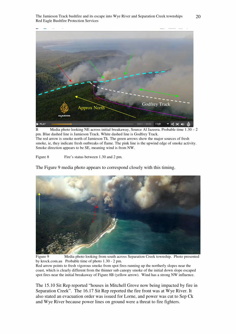
B Media photo looking NE across initial breakaway, Source Al Jazeera. Probable time 1.30 – 2
pm. Blue dashed line is Jamieson Track. White dashed line is Godfrey Track.
The red arrow is smoke north of Jamieson Tk. The green arrows show the major sources of fresh
smoke, ie, they indicate fresh outbreaks of flame. The pink line is the upwind edge of smoke activity.
Smoke direction appears to be SE, meaning wind is from NW.
Figure 8 Fire’s status between 1.30 and 2 pm.
The Figure 9 media photo appears to correspond closely with this timing.
Figure 9 Media photo looking from south across Separation Creek township. Photo presented
by krock.com.au Probable time of photo 1.30 - 2 pm.
Red arrow points to fresh vigorous smoke from spot fires running up the northerly slopes near the
coast, which is clearly different from the thinner sub canopy smoke of the initial down slope escaped
spot fires near the initial breakaway of Figure 8B (yellow arrow). Wind has a strong NW influence.
The 15.10 Sit Rep reported “houses in Mitchell Grove now being impacted by fire in
Separation Creek”. The 16.17 Sit Rep reported the fire front was at Wye River. It
also stated an evacuation order was issued for Lorne, and power was cut to Sep Ck
and Wye River because power lines on ground were a threat to fire fighters.
Godfrey Track Approx North
The Jamieson Track bushfire and its escape into Wye River and Separation Creek townships
Red Eagle Bushfire Protection Services 21
The wording of the control plan in these Sit Reps specified aircraft activity only. The
non-mention of ground fire fighting units is consistent with feedback given to me by
local fire fighters. One advised me that there were several aircraft water drops before
and after 3pm, and that shortly after 3pm, a few CFA units were quelling spot fires in
parts of Separation Creek, some in open defiance of local chiefs, who declared some
areas unsafe. Another fire fighter reported that just after 4pm, there were two CFA
units in Separation Creek. One was quelling spot fires and the other was stationed at
the creek with a pump. One strike team was in Wye River from 8am and saved
several houses from spot fires in the Boulevard area. Thus, on the ground fire fighter
activity during the fire attack was sparse compared to house numbers under threat.
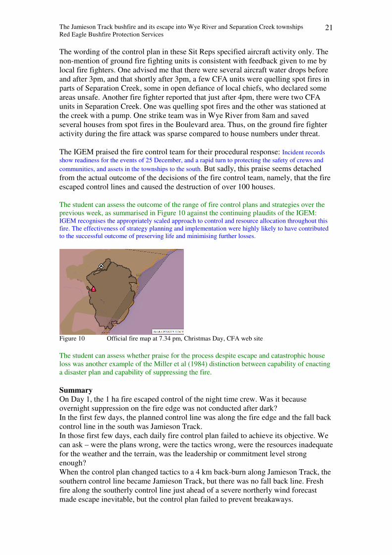
The IGEM praised the fire control team for their procedural response: Incident records
show readiness for the events of 25 December, and a rapid turn to protecting the safety of crews and
communities, and assets in the townships to the south. But sadly, this praise seems detached
from the actual outcome of the decisions of the fire control team, namely, that the fire
escaped control lines and caused the destruction of over 100 houses.
The student can assess the outcome of the range of fire control plans and strategies over the
previous week, as summarised in Figure 10 against the continuing plaudits of the IGEM: IGEM recognises the appropriately scaled approach to control and resource allocation throughout this
fire. The effectiveness of strategy planning and implementation were highly likely to have contributed
to the successful outcome of preserving life and minimising further losses.
Figure 10 Official fire map at 7.34 pm, Christmas Day, CFA web site
The student can assess whether praise for the process despite escape and catastrophic house
loss was another example of the Miller et al (1984) distinction between capability of enacting
a disaster plan and capability of suppressing the fire.
Summary
On Day 1, the 1 ha fire escaped control of the night time crew. Was it because
overnight suppression on the fire edge was not conducted after dark?
In the first few days, the planned control line was along the fire edge and the fall back
control line in the south was Jamieson Track.
In those first few days, each daily fire control plan failed to achieve its objective. We
can ask – were the plans wrong, were the tactics wrong, were the resources inadequate
for the weather and the terrain, was the leadership or commitment level strong
enough?
When the control plan changed tactics to a 4 km back-burn along Jamieson Track, the
southern control line became Jamieson Track, but there was no fall back line. Fresh
fire along the southerly control line just ahead of a severe northerly wind forecast
made escape inevitable, but the control plan failed to prevent breakaways.
The Jamieson Track bushfire and its escape into Wye River and Separation Creek townships
Red Eagle Bushfire Protection Services 22
Chapter 4 The bushfire escape across Jamieson Track
When and where
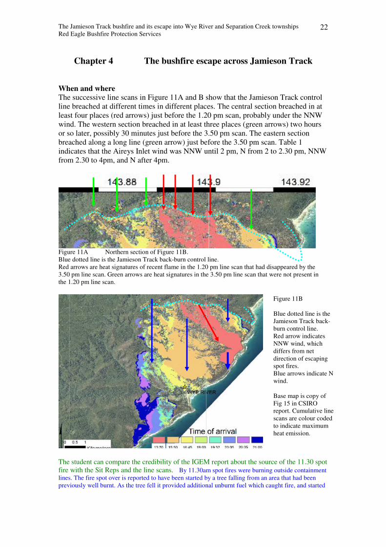
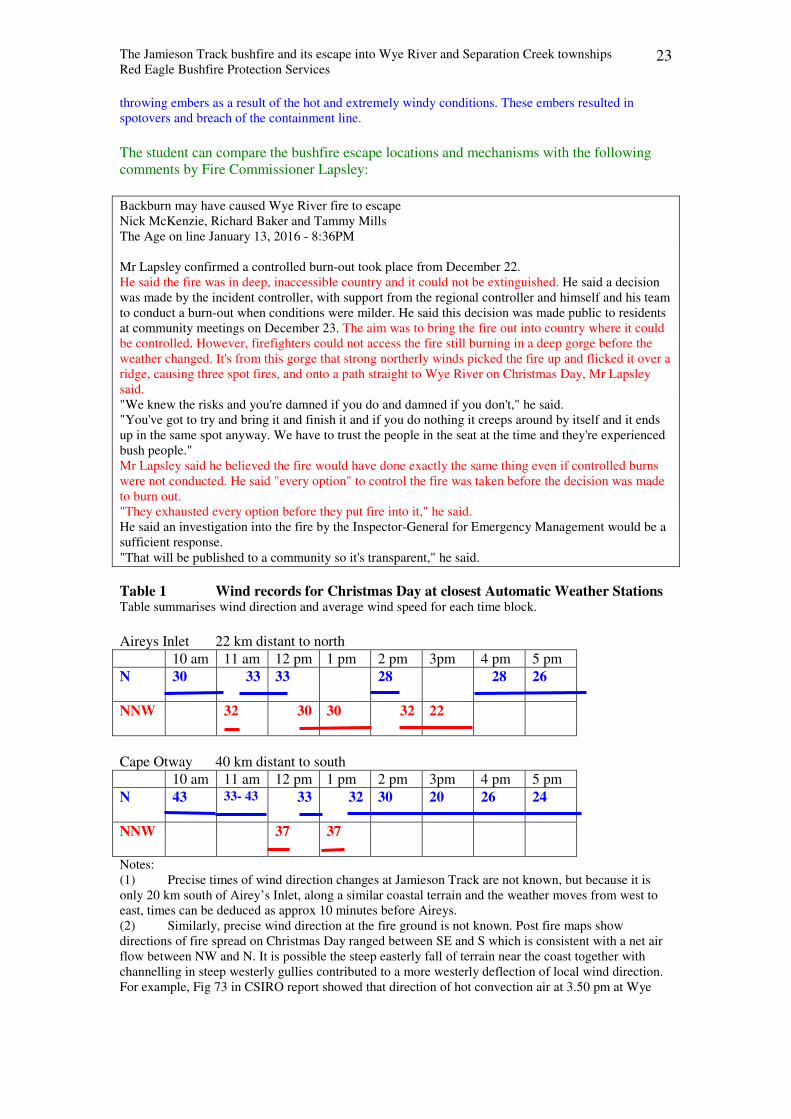
The successive line scans in Figure 11A and B show that the Jamieson Track control
line breached at different times in different places. The central section breached in at
least four places (red arrows) just before the 1.20 pm scan, probably under the NNW
wind. The western section breached in at least three places (green arrows) two hours
or so later, possibly 30 minutes just before the 3.50 pm scan. The eastern section
breached along a long line (green arrow) just before the 3.50 pm scan. Table 1
indicates that the Aireys Inlet wind was NNW until 2 pm, N from 2 to 2.30 pm, NNW
from 2.30 to 4pm, and N after 4pm.
Figure 11A Northern section of Figure 11B.
Blue dotted line is the Jamieson Track back-burn control line.
Red arrows are heat signatures of recent flame in the 1.20 pm line scan that had disappeared by the
3.50 pm line scan. Green arrows are heat signatures in the 3.50 pm line scan that were not present in
the 1.20 pm line scan.
The student can compare the credibility of the IGEM report about the source of the 11.30 spot
fire with the Sit Reps and the line scans. By 11.30am spot fires were burning outside containment
lines. The fire spot over is reported to have been started by a tree falling from an area that had been
previously well burnt. As the tree fell it provided additional unburnt fuel which caught fire, and started
Figure 11B
Blue dotted line is the
Jamieson Track back-
burn control line.
Red arrow indicates
NNW wind, which
differs from net
direction of escaping
spot fires.
Blue arrows indicate N
wind.
Base map is copy of
Fig 15 in CSIRO
report. Cumulative line
scans are colour coded
to indicate maximum
heat emission.
The Jamieson Track bushfire and its escape into Wye River and Separation Creek townships
Red Eagle Bushfire Protection Services 23
throwing embers as a result of the hot and extremely windy conditions. These embers resulted in
spotovers and breach of the containment line.
The student can compare the bushfire escape locations and mechanisms with the following
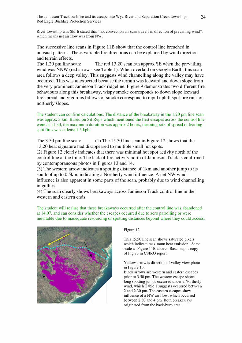
comments by Fire Commissioner Lapsley:
Backburn may have caused Wye River fire to escape
Nick McKenzie, Richard Baker and Tammy Mills
The Age on line January 13, 2016 - 8:36PM
Mr Lapsley confirmed a controlled burn-out took place from December 22.
He said the fire was in deep, inaccessible country and it could not be extinguished. He said a decision
was made by the incident controller, with support from the regional controller and himself and his team
to conduct a burn-out when conditions were milder. He said this decision was made public to residents
at community meetings on December 23. The aim was to bring the fire out into country where it could
be controlled. However, firefighters could not access the fire still burning in a deep gorge before the
weather changed. It's from this gorge that strong northerly winds picked the fire up and flicked it over a
ridge, causing three spot fires, and onto a path straight to Wye River on Christmas Day, Mr Lapsley
said.
"We knew the risks and you're damned if you do and damned if you don't," he said.
"You've got to try and bring it and finish it and if you do nothing it creeps around by itself and it ends
up in the same spot anyway. We have to trust the people in the seat at the time and they're experienced
bush people."
Mr Lapsley said he believed the fire would have done exactly the same thing even if controlled burns
were not conducted. He said "every option" to control the fire was taken before the decision was made
to burn out.
"They exhausted every option before they put fire into it," he said.
He said an investigation into the fire by the Inspector-General for Emergency Management would be a
sufficient response.
"That will be published to a community so it's transparent," he said.
Table 1 Wind records for Christmas Day at closest Automatic Weather Stations Table summarises wind direction and average wind speed for each time block.
Aireys Inlet 22 km distant to north
10 am 11 am 12 pm 1 pm 2 pm 3pm 4 pm 5 pm
N
30 33 33 28 28 26
NNW
32 30 30 32 22
Cape Otway 40 km distant to south
10 am 11 am 12 pm 1 pm 2 pm 3pm 4 pm 5 pm
N
43 33- 43 33 32 30 20 26 24
NNW
37 37
Notes:
(1) Precise times of wind direction changes at Jamieson Track are not known, but because it is
only 20 km south of Airey’s Inlet, along a similar coastal terrain and the weather moves from west to
east, times can be deduced as approx 10 minutes before Aireys.
(2) Similarly, precise wind direction at the fire ground is not known. Post fire maps show
directions of fire spread on Christmas Day ranged between SE and S which is consistent with a net air
flow between NW and N. It is possible the steep easterly fall of terrain near the coast together with
channelling in steep westerly gullies contributed to a more westerly deflection of local wind direction.
For example, Fig 73 in CSIRO report showed that direction of hot convection air at 3.50 pm at Wye
The Jamieson Track bushfire and its escape into Wye River and Separation Creek townships
Red Eagle Bushfire Protection Services 24
River township was SE. It stated that “hot convection air scan travels in direction of prevailing wind”,
which means net air flow was from NW.
The successive line scans in Figure 11B show that the control line breached in
unusual patterns. These variable fire directions can be explained by wind direction
and terrain effects.
The 1.20 pm line scan: The red 13.20 scan ran approx SE when the prevailing
wind was NNW (red arrow - see Table 1). When overlaid on Google Earth, this scan
area follows a deep valley. This suggests wind channelling along the valley may have
occurred. This was unexpected because the terrain was leeward and down slope from
the very prominent Jamieson Track ridgeline. Figure 9 demonstrates two different fire
behaviours along this breakaway, wispy smoke corresponds to down slope leeward
fire spread and vigorous billows of smoke correspond to rapid uphill spot fire runs on
northerly slopes.
The student can confirm calculations. The distance of the breakaway in the 1.20 pm line scan
was approx 3 km. Based on Sit Reps which mentioned the first escapes across the control line
were at 11.30, the maximum duration was approx 2 hours, meaning rate of spread of leading
spot fires was at least 1.5 kph.
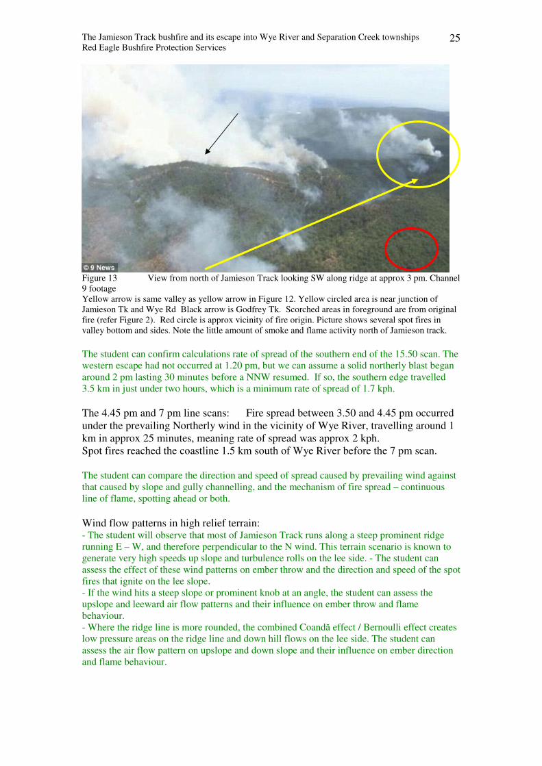
The 3.50 pm line scan: (1) The 15.50 line scan in Figure 12 shows that the
13.20 heat signature had disappeared to multiple small hot spots.
(2) Figure 12 clearly indicates that there was minimal hot spot activity north of the
control line at the time. The lack of fire activity north of Jamieson Track is confirmed
by contemporaneous photos in Figures 13 and 14.
(3) The western arrow indicates a spotting distance of 1km and another jump to its
south of up to 0.5km, indicating a Northerly wind influence. A net NW wind
influence is also apparent in some parts of the scan, probably due to wind channelling
in gullies.
(4) The scan clearly shows breakaways across Jamieson Track control line in the
western and eastern ends.
The student will realise that these breakaways occurred after the control line was abandoned
at 14.07, and can consider whether the escapes occurred due to zero patrolling or were
inevitable due to inadequate resourcing or spotting distances beyond where they could access.
Figure 12
This 15.50 line scan shows saturated pixels
which indicate maximum heat emission. Same
scale as Figure 11B above. Base map is copy
of Fig 73 in CSIRO report.
Yellow arrow is direction of valley view photo
in Figure 13. Black arrows are western and eastern escapes
prior to 3.50 pm. The western escape shows
long spotting jumps occurred under a Northerly
wind, which Table 1 suggests occurred between
2 and 2.30 pm. The eastern escapes show
influence of a NW air flow, which occurred
between 2.30 and 4 pm. Both breakaways
originated from the back-burn area.
The Jamieson Track bushfire and its escape into Wye River and Separation Creek townships
Red Eagle Bushfire Protection Services 25
Figure 13 View from north of Jamieson Track looking SW along ridge at approx 3 pm. Channel
9 footage
Yellow arrow is same valley as yellow arrow in Figure 12. Yellow circled area is near junction of
Jamieson Tk and Wye Rd Black arrow is Godfrey Tk. Scorched areas in foreground are from original
fire (refer Figure 2). Red circle is approx vicinity of fire origin. Picture shows several spot fires in
valley bottom and sides. Note the little amount of smoke and flame activity north of Jamieson track.
The student can confirm calculations rate of spread of the southern end of the 15.50 scan. The
western escape had not occurred at 1.20 pm, but we can assume a solid northerly blast began
around 2 pm lasting 30 minutes before a NNW resumed. If so, the southern edge travelled
3.5 km in just under two hours, which is a minimum rate of spread of 1.7 kph.
The 4.45 pm and 7 pm line scans: Fire spread between 3.50 and 4.45 pm occurred
under the prevailing Northerly wind in the vicinity of Wye River, travelling around 1
km in approx 25 minutes, meaning rate of spread was approx 2 kph.
Spot fires reached the coastline 1.5 km south of Wye River before the 7 pm scan.
The student can compare the direction and speed of spread caused by prevailing wind against
that caused by slope and gully channelling, and the mechanism of fire spread – continuous
line of flame, spotting ahead or both.
Wind flow patterns in high relief terrain: - The student will observe that most of Jamieson Track runs along a steep prominent ridge
running E – W, and therefore perpendicular to the N wind. This terrain scenario is known to
generate very high speeds up slope and turbulence rolls on the lee side. - The student can
assess the effect of these wind patterns on ember throw and the direction and speed of the spot
fires that ignite on the lee slope.
- If the wind hits a steep slope or prominent knob at an angle, the student can assess the
upslope and leeward air flow patterns and their influence on ember throw and flame
behaviour.
- Where the ridge line is more rounded, the combined Coandă effect / Bernoulli effect creates
low pressure areas on the ridge line and down hill flows on the lee side. The student can
assess the air flow pattern on upslope and down slope and their influence on ember direction
and flame behaviour.
The Jamieson Track bushfire and its escape into Wye River and Separation Creek townships
Red Eagle Bushfire Protection Services 26
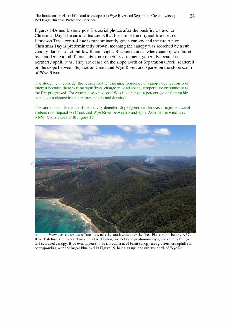
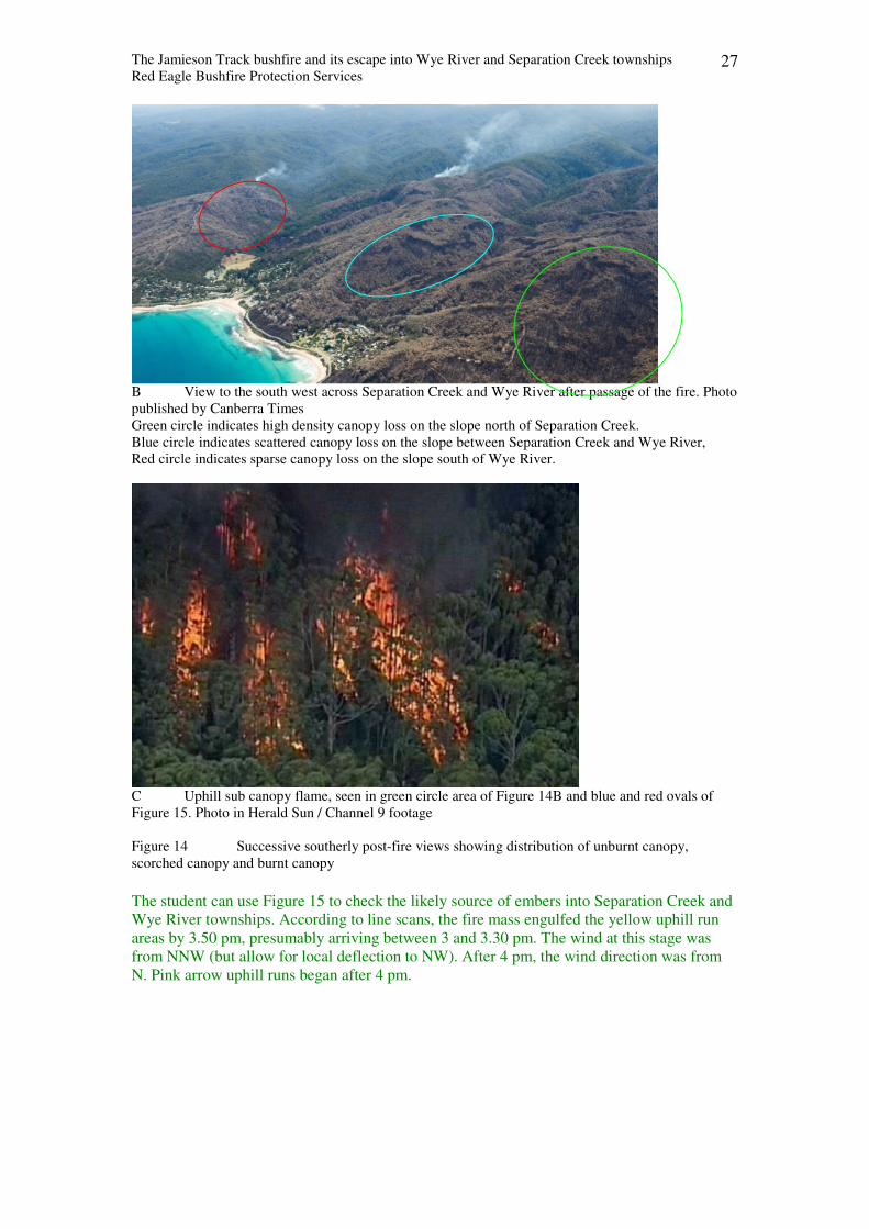
Figures 14A and B show post fire aerial photos after the bushfire’s travel on
Christmas Day. The curious feature is that the site of the original fire north of
Jamieson Track control line is predominantly green canopy and the fire run on
Christmas Day is predominantly brown, meaning the canopy was scorched by a sub
canopy flame – a hot but low flame height. Blackened areas where canopy was burnt
by a moderate to tall flame height are much less frequent, generally located on
northerly uphill runs. They are dense on the slope north of Separation Creek, scattered
on the slope between Separation Creek and Wye River, and sparse on the slope south
of Wye River.
The student can consider the reason for the lessening frequency of canopy denudation is of
interest because there was no significant change in wind speed, temperature or humidity as
the fire progressed. For example was it slope? Was it a change in percentage of flammable
trunks, or a change in understorey height and density?
The student can determine if the heavily denuded slope (green circle) was a major source of
embers into Separation Creek and Wye River between 3 and 4pm. Assume the wind was
NNW. Cross check with Figure 15.
A View across Jamieson Track towards the south west after the fire. Photo published by ABC.
Blue dash line is Jamieson Track. It is the dividing line between predominantly green canopy foliage
and scorched canopy. Blue oval appears to be a broad area of burnt canopy along a northern uphill run,
corresponding with the larger blue oval in Figure 15, being an upslope run just north of Wye Rd.
The Jamieson Track bushfire and its escape into Wye River and Separation Creek townships
Red Eagle Bushfire Protection Services 27
B View to the south west across Separation Creek and Wye River after passage of the fire. Photo
published by Canberra Times
Green circle indicates high density canopy loss on the slope north of Separation Creek.
Blue circle indicates scattered canopy loss on the slope between Separation Creek and Wye River,
Red circle indicates sparse canopy loss on the slope south of Wye River.
C Uphill sub canopy flame, seen in green circle area of Figure 14B and blue and red ovals of
Figure 15. Photo in Herald Sun / Channel 9 footage
Figure 14 Successive southerly post-fire views showing distribution of unburnt canopy,
scorched canopy and burnt canopy
The student can use Figure 15 to check the likely source of embers into Separation Creek and
Wye River townships. According to line scans, the fire mass engulfed the yellow uphill run
areas by 3.50 pm, presumably arriving between 3 and 3.30 pm. The wind at this stage was
from NNW (but allow for local deflection to NW). After 4 pm, the wind direction was from
N. Pink arrow uphill runs began after 4 pm.
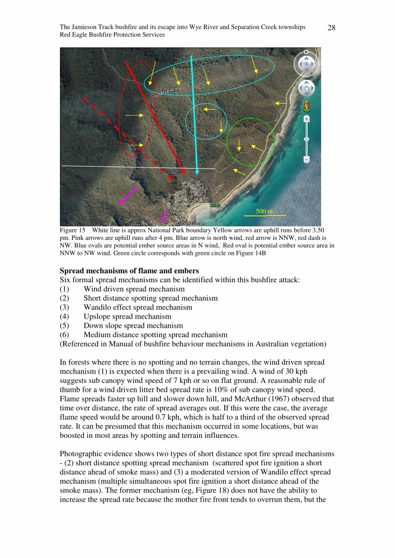
The Jamieson Track bushfire and its escape into Wye River and Separation Creek townships
Red Eagle Bushfire Protection Services 28
Figure 15 White line is approx National Park boundary Yellow arrows are uphill runs before 3.50
pm. Pink arrows are uphill runs after 4 pm. Blue arrow is north wind, red arrow is NNW, red dash is
NW. Blue ovals are potential ember source areas in N wind, Red oval is potential ember source area in
NNW to NW wind. Green circle corresponds with green circle on Figure 14B
Spread mechanisms of flame and embers
Six formal spread mechanisms can be identified within this bushfire attack:
(1) Wind driven spread mechanism
(2) Short distance spotting spread mechanism
(3) Wandilo effect spread mechanism
(4) Upslope spread mechanism
(5) Down slope spread mechanism
(6) Medium distance spotting spread mechanism
(Referenced in Manual of bushfire behaviour mechanisms in Australian vegetation)
In forests where there is no spotting and no terrain changes, the wind driven spread
mechanism (1) is expected when there is a prevailing wind. A wind of 30 kph
suggests sub canopy wind speed of 7 kph or so on flat ground. A reasonable rule of
thumb for a wind driven litter bed spread rate is 10% of sub canopy wind speed.
Flame spreads faster up hill and slower down hill, and McArthur (1967) observed that
time over distance, the rate of spread averages out. If this were the case, the average
flame speed would be around 0.7 kph, which is half to a third of the observed spread
rate. It can be presumed that this mechanism occurred in some locations, but was
boosted in most areas by spotting and terrain influences.
Photographic evidence shows two types of short distance spot fire spread mechanisms
- (2) short distance spotting spread mechanism (scattered spot fire ignition a short
distance ahead of smoke mass) and (3) a moderated version of Wandilo effect spread
mechanism (multiple simultaneous spot fire ignition a short distance ahead of the
smoke mass). The former mechanism (eg, Figure 18) does not have the ability to
increase the spread rate because the mother fire front tends to overrun them, but the
500 m
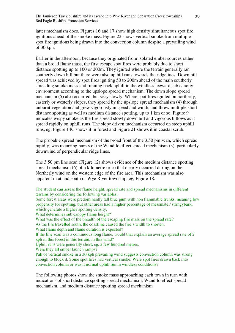
The Jamieson Track bushfire and its escape into Wye River and Separation Creek townships
Red Eagle Bushfire Protection Services 29
latter mechanism does. Figures 16 and 17 show high density simultaneous spot fire
ignitions ahead of the smoke mass. Figure 22 shows vertical smoke from multiple
spot fire ignitions being drawn into the convection column despite a prevailing wind
of 30 kph.
Earlier in the afternoon, because they originated from isolated ember sources rather
than a broad flame mass, the first escape spot fires were probably due to short
distance spotting up to 100 or 200m. They ignited where the terrain generally ran
southerly down hill but there were also up hill runs towards the ridgelines. Down hill
spread was achieved by spot fires igniting 50 to 200m ahead of the main southerly
spreading smoke mass and running back uphill in the windless leeward sub canopy
environment according to the upslope spread mechanism. The down slope spread
mechanism (5) also occurred, but very slowly. Where spot fires ignited on northerly,
easterly or westerly slopes, they spread by the upslope spread mechanism (4) through
unburnt vegetation and grew vigorously in speed and width, and threw multiple short
distance spotting as well as medium distance spotting, up to 1 km or so. Figure 9
indicates wispy smoke as the fire spread slowly down hill and vigorous billows as it
spread rapidly on uphill runs. The slope driven mechanism occurred on steep uphill
runs, eg, Figure 14C shows it in forest and Figure 21 shows it in coastal scrub.
The probable spread mechanism of the broad front of the 3.50 pm scan, which spread
rapidly, was recurring bursts of the Wandilo effect spread mechanism (3), particularly
downwind of perpendicular ridge lines.
The 3.50 pm line scan (Figure 12) shows evidence of the medium distance spotting
spread mechanism (6) of a kilometre or so that clearly occurred during on the
Northerly wind on the western edge of the fire area. This mechanism was also
apparent in at and south of Wye River township, eg, Figure 18.
The student can assess the flame height, spread rate and spread mechanisms in different
terrains by considering the following variables:
Some forest areas were predominantly tall blue gum with non flammable trunks, meaning low
propensity for spotting, but other areas had a higher percentage of messmate / stringybark,
which generate a higher spotting density.
What determines sub canopy flame height?
What was the effect of the breadth of the escaping fire mass on the spread rate?
As the fire travelled south, the coastline caused the fire’s width to shorten.
What flame depth and flame duration is expected?
If the line scan was a continuous long flame, would that explain an average spread rate of 2
kph in this forest in this terrain, in this wind?
Uphill runs were generally short, eg, a few hundred metres.
Were they all ember launch ramps?
Pall of vertical smoke in a 30 kph prevailing wind suggests convection column was strong
enough to block it. Some spot fires had vertical smoke. Were spot fires drawn back into
convection column or was it normal uphill run in windless conditions?
The following photos show the smoke mass approaching each town in turn with
indications of short distance spotting spread mechanism, Wandilo effect spread
mechanism, and medium distance spotting spread mechanism
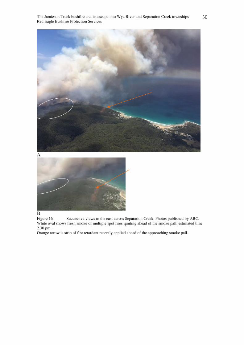
The Jamieson Track bushfire and its escape into Wye River and Separation Creek townships
Red Eagle Bushfire Protection Services 30
A
B Figure 16 Successive views to the east across Separation Creek. Photos published by ABC.
White oval shows fresh smoke of multiple spot fires igniting ahead of the smoke pall, estimated time
2.30 pm .
Orange arrow is strip of fire retardant recently applied ahead of the approaching smoke pall.
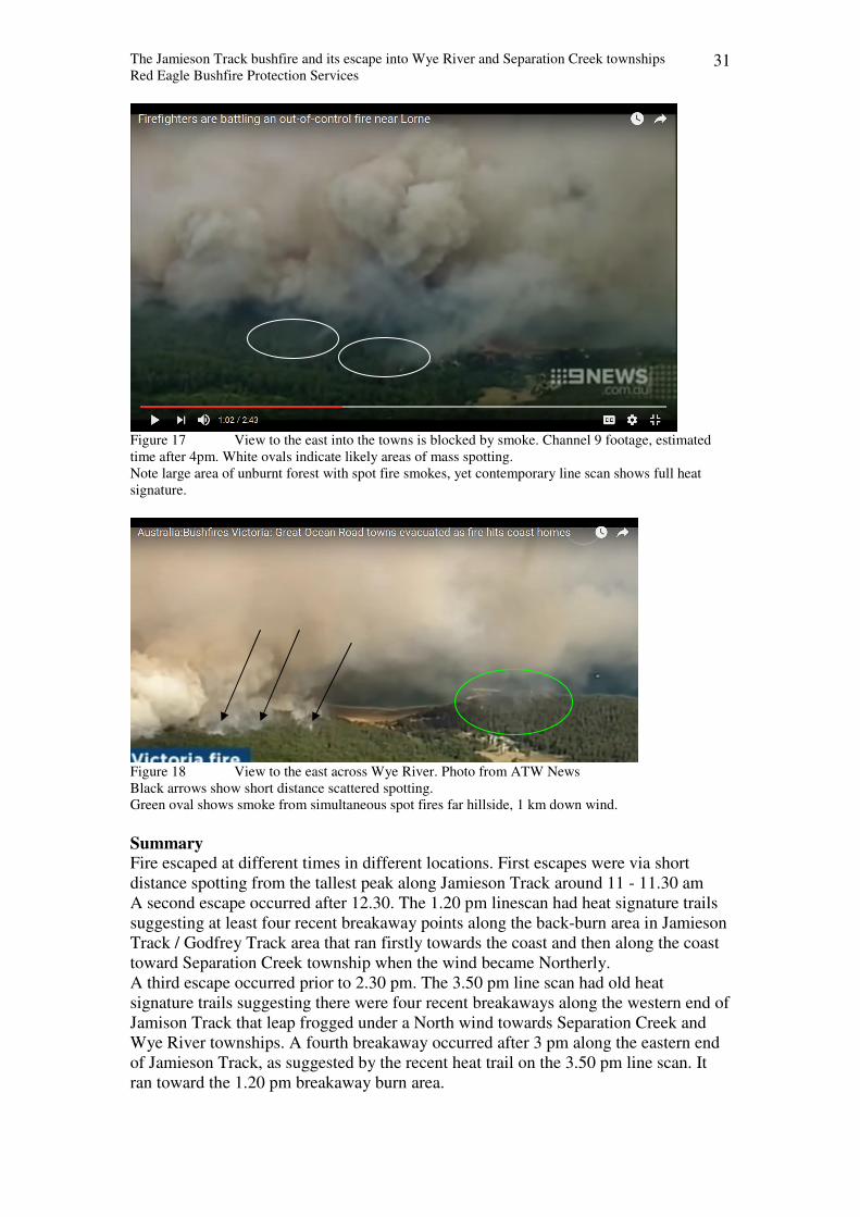
The Jamieson Track bushfire and its escape into Wye River and Separation Creek townships
Red Eagle Bushfire Protection Services 31
Figure 17 View to the east into the towns is blocked by smoke. Channel 9 footage, estimated
time after 4pm. White ovals indicate likely areas of mass spotting.
Note large area of unburnt forest with spot fire smokes, yet contemporary line scan shows full heat
signature.
Figure 18 View to the east across Wye River. Photo from ATW News
Black arrows show short distance scattered spotting.
Green oval shows smoke from simultaneous spot fires far hillside, 1 km down wind.
Summary
Fire escaped at different times in different locations. First escapes were via short
distance spotting from the tallest peak along Jamieson Track around 11 - 11.30 am
A second escape occurred after 12.30. The 1.20 pm linescan had heat signature trails
suggesting at least four recent breakaway points along the back-burn area in Jamieson
Track / Godfrey Track area that ran firstly towards the coast and then along the coast
toward Separation Creek township when the wind became Northerly.
A third escape occurred prior to 2.30 pm. The 3.50 pm line scan had old heat
signature trails suggesting there were four recent breakaways along the western end of
Jamison Track that leap frogged under a North wind towards Separation Creek and
Wye River townships. A fourth breakaway occurred after 3 pm along the eastern end
of Jamieson Track, as suggested by the recent heat trail on the 3.50 pm line scan. It
ran toward the 1.20 pm breakaway burn area.
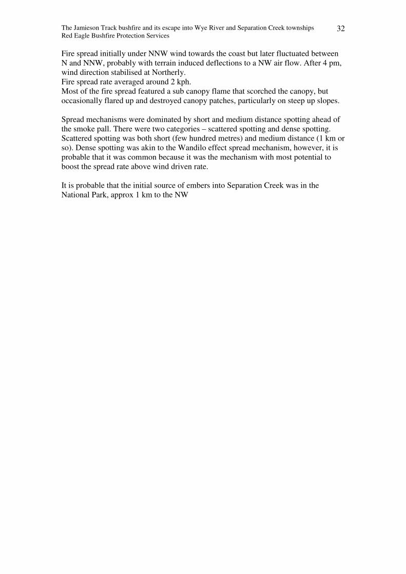
The Jamieson Track bushfire and its escape into Wye River and Separation Creek townships
Red Eagle Bushfire Protection Services 32
Fire spread initially under NNW wind towards the coast but later fluctuated between
N and NNW, probably with terrain induced deflections to a NW air flow. After 4 pm,
wind direction stabilised at Northerly.
Fire spread rate averaged around 2 kph.
Most of the fire spread featured a sub canopy flame that scorched the canopy, but
occasionally flared up and destroyed canopy patches, particularly on steep up slopes.
Spread mechanisms were dominated by short and medium distance spotting ahead of
the smoke pall. There were two categories – scattered spotting and dense spotting.
Scattered spotting was both short (few hundred metres) and medium distance (1 km or
so). Dense spotting was akin to the Wandilo effect spread mechanism, however, it is
probable that it was common because it was the mechanism with most potential to
boost the spread rate above wind driven rate.
It is probable that the initial source of embers into Separation Creek was in the
National Park, approx 1 km to the NW
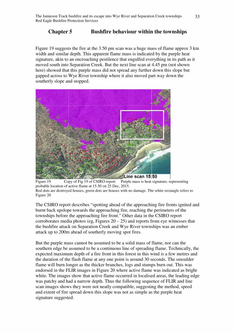
The Jamieson Track bushfire and its escape into Wye River and Separation Creek townships
Red Eagle Bushfire Protection Services 33
Chapter 5 Bushfire behaviour within the townships
Figure 19 suggests the fire at the 3.50 pm scan was a huge mass of flame approx 3 km
width and similar depth. This apparent flame mass is indicated by the purple heat
signature, akin to an encroaching pestilence that engulfed everything in its path as it
moved south into Separation Creek. But the next line scan at 4.45 pm (not shown
here) showed that this purple mass did not spread any further down this slope but
gapped across to Wye River township where it also moved part way down the
southerly slope and stopped.
Figure 19 Copy of Fig 19 of CSIRO report Purple mass is heat signature, representing
probable location of active flame at 15.50 on 25 Dec, 2015.
Red dots are destroyed houses; green dots are houses with no damage. The white rectangle refers to
Figure 20
The CSIRO report describes “spotting ahead of the approaching fire fronts ignited and
burnt back upslope towards the approaching fire, reaching the perimeters of the
townships before the approaching fire front.” Other data in the CSIRO report
corroborates media photos (eg, Figures 20 – 25) and reports from eye witnesses that
the bushfire attack on Separation Creek and Wye River townships was an ember
attack up to 200m ahead of southerly moving spot fires.
But the purple mass cannot be assumed to be a solid mass of flame, nor can the
southern edge be assumed to be a continuous line of spreading flame. Technically, the
expected maximum depth of a fire front in this forest in this wind is a few metres and
the duration of the flash flame at any one point is around 30 seconds. The smoulder
flame will burn longer as the thicker branches, logs and stumps burn out. This was
endorsed in the FLIR images in Figure 20 where active flame was indicated as bright
white. The images show that active flame occurred in localised areas, the leading edge
was patchy and had a narrow depth. Thus the following sequence of FLIR and line
scan images shows they were not neatly compatible, suggesting the method, speed
and extent of fire spread down this slope was not as simple as the purple heat
signature suggested.
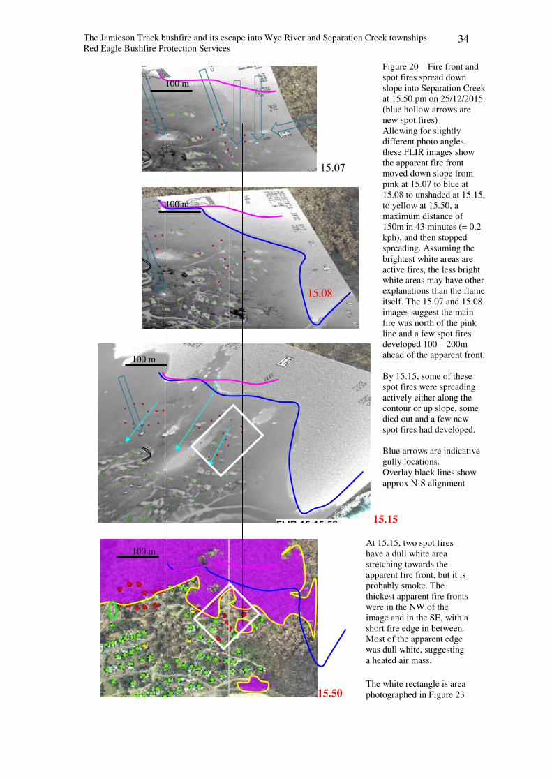
The Jamieson Track bushfire and its escape into Wye River and Separation Creek townships
Red Eagle Bushfire Protection Services 34
15.07
15.15
15.50
Figure 20 Fire front and
spot fires spread down
slope into Separation Creek
at 15.50 pm on 25/12/2015.
(blue hollow arrows are
new spot fires)
Allowing for slightly
different photo angles,
these FLIR images show
the apparent fire front
moved down slope from
pink at 15.07 to blue at
15.08 to unshaded at 15.15,
to yellow at 15.50, a
maximum distance of
150m in 43 minutes (= 0.2
kph), and then stopped
spreading. Assuming the
brightest white areas are
active fires, the less bright
white areas may have other
explanations than the flame
itself. The 15.07 and 15.08
images suggest the main
fire was north of the pink
line and a few spot fires
developed 100 – 200m
ahead of the apparent front.
By 15.15, some of these
spot fires were spreading
actively either along the
contour or up slope, some
died out and a few new
spot fires had developed.
Blue arrows are indicative
gully locations.
Overlay black lines show
approx N-S alignment
15.08
At 15.15, two spot fires
have a dull white area
stretching towards the
apparent fire front, but it is
probably smoke. The
thickest apparent fire fronts
were in the NW of the
image and in the SE, with a
short fire edge in between.
Most of the apparent edge
was dull white, suggesting
a heated air mass.
The white rectangle is area
photographed in Figure 23
100 m
100 m
100 m
100 m
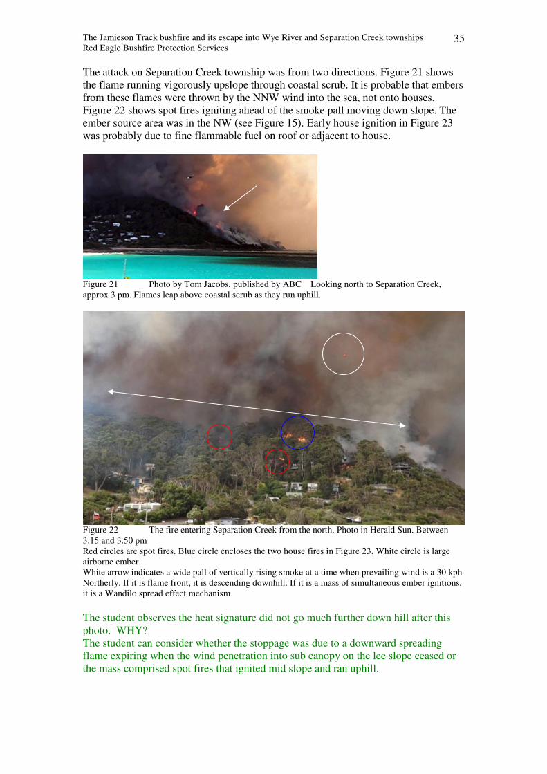
The Jamieson Track bushfire and its escape into Wye River and Separation Creek townships
Red Eagle Bushfire Protection Services 35
The attack on Separation Creek township was from two directions. Figure 21 shows
the flame running vigorously upslope through coastal scrub. It is probable that embers
from these flames were thrown by the NNW wind into the sea, not onto houses.
Figure 22 shows spot fires igniting ahead of the smoke pall moving down slope. The
ember source area was in the NW (see Figure 15). Early house ignition in Figure 23
was probably due to fine flammable fuel on roof or adjacent to house.
Figure 21 Photo by Tom Jacobs, published by ABC Looking north to Separation Creek,
approx 3 pm. Flames leap above coastal scrub as they run uphill.
Figure 22 The fire entering Separation Creek from the north. Photo in Herald Sun. Between
3.15 and 3.50 pm
Red circles are spot fires. Blue circle encloses the two house fires in Figure 23. White circle is large
airborne ember.
White arrow indicates a wide pall of vertically rising smoke at a time when prevailing wind is a 30 kph
Northerly. If it is flame front, it is descending downhill. If it is a mass of simultaneous ember ignitions,
it is a Wandilo spread effect mechanism
The student observes the heat signature did not go much further down hill after this
photo. WHY?
The student can consider whether the stoppage was due to a downward spreading
flame expiring when the wind penetration into sub canopy on the lee slope ceased or
the mass comprised spot fires that ignited mid slope and ran uphill.
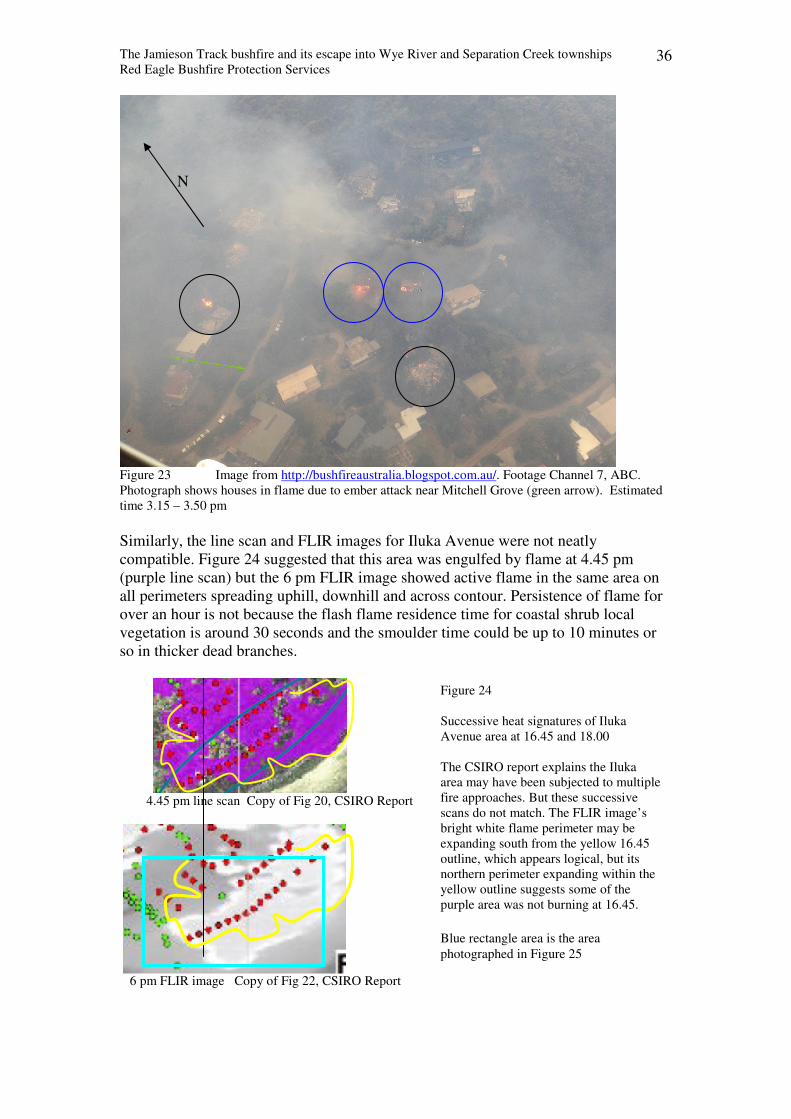
The Jamieson Track bushfire and its escape into Wye River and Separation Creek townships
Red Eagle Bushfire Protection Services 36
Figure 23 Image from http://bushfireaustralia.blogspot.com.au/. Footage Channel 7, ABC.
Photograph shows houses in flame due to ember attack near Mitchell Grove (green arrow). Estimated
time 3.15 – 3.50 pm
Similarly, the line scan and FLIR images for Iluka Avenue were not neatly
compatible. Figure 24 suggested that this area was engulfed by flame at 4.45 pm
(purple line scan) but the 6 pm FLIR image showed active flame in the same area on
all perimeters spreading uphill, downhill and across contour. Persistence of flame for
over an hour is not because the flash flame residence time for coastal shrub local
vegetation is around 30 seconds and the smoulder time could be up to 10 minutes or
so in thicker dead branches.
4.45 pm line scan Copy of Fig 20, CSIRO Report
6 pm FLIR image Copy of Fig 22, CSIRO Report
N
Figure 24
Successive heat signatures of Iluka
Avenue area at 16.45 and 18.00
The CSIRO report explains the Iluka
area may have been subjected to multiple
fire approaches. But these successive
scans do not match. The FLIR image’s
bright white flame perimeter may be
expanding south from the yellow 16.45
outline, which appears logical, but its
northern perimeter expanding within the
yellow outline suggests some of the
purple area was not burning at 16.45.
Blue rectangle area is the area
photographed in Figure 25
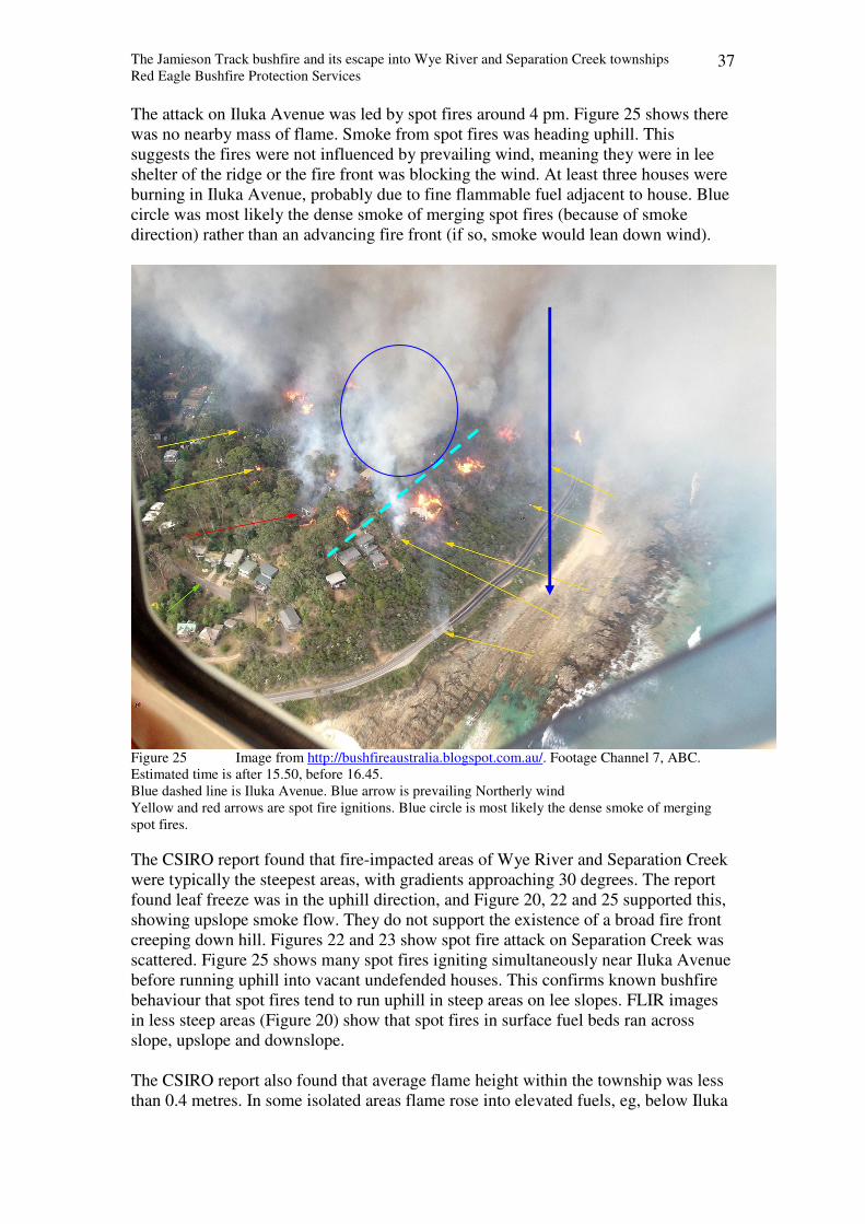
The Jamieson Track bushfire and its escape into Wye River and Separation Creek townships
Red Eagle Bushfire Protection Services 37
The attack on Iluka Avenue was led by spot fires around 4 pm. Figure 25 shows there
was no nearby mass of flame. Smoke from spot fires was heading uphill. This
suggests the fires were not influenced by prevailing wind, meaning they were in lee
shelter of the ridge or the fire front was blocking the wind. At least three houses were
burning in Iluka Avenue, probably due to fine flammable fuel adjacent to house. Blue
circle was most likely the dense smoke of merging spot fires (because of smoke
direction) rather than an advancing fire front (if so, smoke would lean down wind).
Figure 25 Image from http://bushfireaustralia.blogspot.com.au/. Footage Channel 7, ABC.
Estimated time is after 15.50, before 16.45.
Blue dashed line is Iluka Avenue. Blue arrow is prevailing Northerly wind
Yellow and red arrows are spot fire ignitions. Blue circle is most likely the dense smoke of merging
spot fires.
The CSIRO report found that fire-impacted areas of Wye River and Separation Creek
were typically the steepest areas, with gradients approaching 30 degrees. The report
found leaf freeze was in the uphill direction, and Figure 20, 22 and 25 supported this,
showing upslope smoke flow. They do not support the existence of a broad fire front
creeping down hill. Figures 22 and 23 show spot fire attack on Separation Creek was
scattered. Figure 25 shows many spot fires igniting simultaneously near Iluka Avenue
before running uphill into vacant undefended houses. This confirms known bushfire
behaviour that spot fires tend to run uphill in steep areas on lee slopes. FLIR images
in less steep areas (Figure 20) show that spot fires in surface fuel beds ran across
slope, upslope and downslope.
The CSIRO report also found that average flame height within the township was less
than 0.4 metres. In some isolated areas flame rose into elevated fuels, eg, below Iluka
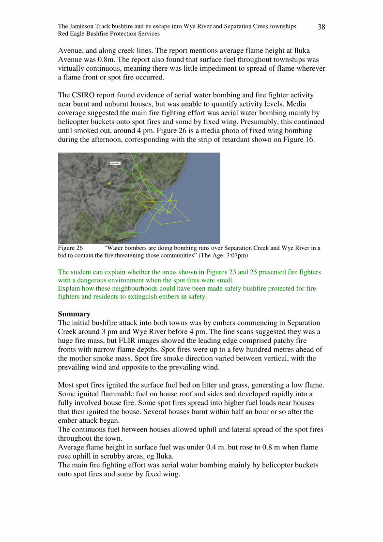
The Jamieson Track bushfire and its escape into Wye River and Separation Creek townships
Red Eagle Bushfire Protection Services 38
Avenue, and along creek lines. The report mentions average flame height at Iluka
Avenue was 0.8m. The report also found that surface fuel throughout townships was
virtually continuous, meaning there was little impediment to spread of flame wherever
a flame front or spot fire occurred.
The CSIRO report found evidence of aerial water bombing and fire fighter activity
near burnt and unburnt houses, but was unable to quantify activity levels. Media
coverage suggested the main fire fighting effort was aerial water bombing mainly by
helicopter buckets onto spot fires and some by fixed wing. Presumably, this continued
until smoked out, around 4 pm. Figure 26 is a media photo of fixed wing bombing
during the afternoon, corresponding with the strip of retardant shown on Figure 16.
Figure 26 “Water bombers are doing bombing runs over Separation Creek and Wye River in a
bid to contain the fire threatening those communities” (The Age, 3:07pm)
The student can explain whether the areas shown in Figures 23 and 25 presented fire fighters
with a dangerous environment when the spot fires were small.
Explain how these neighbourhoods could have been made safely bushfire protected for fire
fighters and residents to extinguish embers in safety.
Summary
The initial bushfire attack into both towns was by embers commencing in Separation
Creek around 3 pm and Wye River before 4 pm. The line scans suggested they was a
huge fire mass, but FLIR images showed the leading edge comprised patchy fire
fronts with narrow flame depths. Spot fires were up to a few hundred metres ahead of
the mother smoke mass. Spot fire smoke direction varied between vertical, with the
prevailing wind and opposite to the prevailing wind.
Most spot fires ignited the surface fuel bed on litter and grass, generating a low flame.
Some ignited flammable fuel on house roof and sides and developed rapidly into a
fully involved house fire. Some spot fires spread into higher fuel loads near houses
that then ignited the house. Several houses burnt within half an hour or so after the
ember attack began.
The continuous fuel between houses allowed uphill and lateral spread of the spot fires
throughout the town.
Average flame height in surface fuel was under 0.4 m. but rose to 0.8 m when flame
rose uphill in scrubby areas, eg Iluka.
The main fire fighting effort was aerial water bombing mainly by helicopter buckets
onto spot fires and some by fixed wing.

The Jamieson Track bushfire and its escape into Wye River and Separation Creek townships
Red Eagle Bushfire Protection Services 39
Chapter 6 Preparation of the towns for a bushfire attack
This discussion considers a bushfire attacking from the North.
Figure 27 shows the southern boundary of National Park is a line on a map. There is
no boundary track or fence line between public and private property. From the fire’s
point of view, if there is no fuel reduced infrastructure, it will run seamlessly across
the boundary. The first upwind track from Separation Creek is the Wye Road which
crosses the National Park diagonally along a ridge line. It theoretically could have
been fuel reduced along its northerly slopes to prevent some flame run ups and
consequent ember launch activity.
A Copy of DELWP map, http://nremap-sc.nre.vic.gov.au/MapShare.v2/imf.jsp?site=forestexplorer
Blue ovals indicate northerly upslope runs of relevance for a bushfire attack from the north.
B 3D aerial view of townships overlain by the area burnt by the bushfire (shaded brown) and the
unburnt area (shown as unshaded).
Figure 27 White line is approx southern boundary of National Park. Yellow arrows indicate down
slope runs. Green arrow indicates up slope run. Blue arrow indicates approx air flow of a Northerly
wind.
300 m N
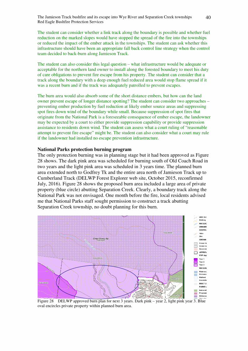
The Jamieson Track bushfire and its escape into Wye River and Separation Creek townships
Red Eagle Bushfire Protection Services 40
The student can consider whether a link track along the boundary is possible and whether fuel
reduction on the marked slopes would have stopped the spread of the fire into the townships
or reduced the impact of the ember attack in the townships. The student can ask whether this
infrastructure should have been an appropriate fall back control line strategy when the control
team decided to back-burn along Jamieson Track.
The student can also consider this legal question – what infrastructure would be adequate or
acceptable for the northern land owner to install along the forested boundary to meet his duty
of care obligations to prevent fire escape from his property. The student can consider that a
track along the boundary with a deep enough fuel reduced area would stop flame spread if it
was a recent burn and if the track was adequately patrolled to prevent escapes.
The burn area would also absorb some of the short distance embers, but how can the land
owner prevent escape of longer distance spotting? The student can consider two approaches –
preventing ember production by fuel reduction at likely ember source areas and suppressing
spot fires down wind of the boundary while small. Because suppression of spot fires that
originate from the National Park is a foreseeable consequence of ember escape, the landowner
may be expected by a court to either provide suppression capability or provide suppression
assistance to residents down wind. The student can assess what a court ruling of “reasonable
attempt to prevent fire escape” might be. The student can also consider what a court may rule
if the landowner had installed no escape prevention infrastructure.
National Parks protection burning program
The only protection burning was in planning stage but it had been approved as Figure
28 shows. The dark pink area was scheduled for burning south of Old Coach Road in
two years and the light pink area was scheduled in 3 years time. The planned burn
area extended north to Godfrey Tk and the entire area north of Jamieson Track up to
Cumberland Track (DELWP Forest Explorer web site, October 2015, reconfirmed
July, 2016). Figure 28 shows the proposed burn area included a large area of private
property (blue circle) abutting Separation Creek. Clearly, a boundary track along the
National Park was not envisaged. One month before the fire, local residents advised
me that National Parks staff sought permission to construct a track abutting
Separation Creek township, no doubt planning for this burn.
Figure 28 DELWP approved burn plan for next 3 years. Dark pink – year 2, light pink year 3. Blue
oval encircles private property within planned burn area.
The Jamieson Track bushfire and its escape into Wye River and Separation Creek townships
Red Eagle Bushfire Protection Services 41
Formal public land bushfire planning
In 2015, the predecessor of DELWP published the Barwon Otway Strategic Bushfire
Plan. Its Map 8 showed that the public land around Wye River area was classified as a
Bushfire Moderation Zone. Bushfire moderation zone: where there is fuel management to reduce the speed and intensity of
bushfires, either close to towns or as they spread through the landscape
Its Map 9 showed they expected the public land around Wye River area to be burnt 5
to 6 times over the next 40 years.
The document explained their new risk based planning approach. The stated DELWP
guiding premise was that an area with maximum fuel hazard was at maximum risk.
They explained that this also meant maximum risk of damaging to houses and other
assets, but they did not clarify that the Phoenix risk model was referring to fuel loads
in 1 ha or 4 ha blocks of public land and that houses were on private property that was
usually distant from public land but at worst was adjacent to public land.
The student can assess whether its guiding principle of maximum fuel load equalling
maximum risk is appropriate since the theory behind the McArthur model for calculating rate
of spread was disproven for wind driven fires a decade or more ago. [The Phoenix risk model
uses the McArthur theory, which is that rate of flame spread is proportional to fine fuel load].
The student can assess whether the DELWP understanding that maximum fuel load is the sum
of the fine fuel components on a given site (as its publication “Overall Fuel Hazard Guide
describes) or the fuel load consumed by the flash flame phase, which is typically a small to
medium percentage of the former. The student can compare DELWP’s maximum fuel load
approach with not so recent research by Vesta and Burrows which confirmed that the tall
flash flame consumes only the top layer of the litter bed to generate flame height and flame
spread rate.
The Plan said “Bushfires, and our fuel management strategy, reduce fuel hazard and
so reduce bushfire risk. The remaining risk is called the residual risk”.
The student can explain if considering bushfire as a means of reducing bushfire risk could be
perceived as a conflict of interest or not.
The DELWP Plan said methodology for developing this plan was based on the
International Standard for Risk Management, ISO 31,000. The risk assessment
process aimed to determine the likelihood and consequence of a major bushfire
impacting on people and properties.
The student can compare the value or relevance of using a risk based methodology like ISO
31,000, whose aim is to create value (it asks - what is the cost of defence and is it greater than
the loss if no defence expenditure occurred), with a threat based methodology like ISO 27,000
which aims to identify specific threats and develop actions to mitigate or manage those
threats.
The DELWP Plan used the Phoenix risk model to map likelihood of bushfire origins
and consequences, in particular, potential house loss scenarios, and then prioritised to
“protect those things at highest risk through the mitigation actions in this plan”. for
example, “DELWP has assumed that properties will be affected when fire intensity or
ember density reach particular thresholds (intensity > 10,000 kW/m or ember density
> 2.5 embers/m2” (DELWP, 2015, Measuring Bushfire Risk in Victoria)
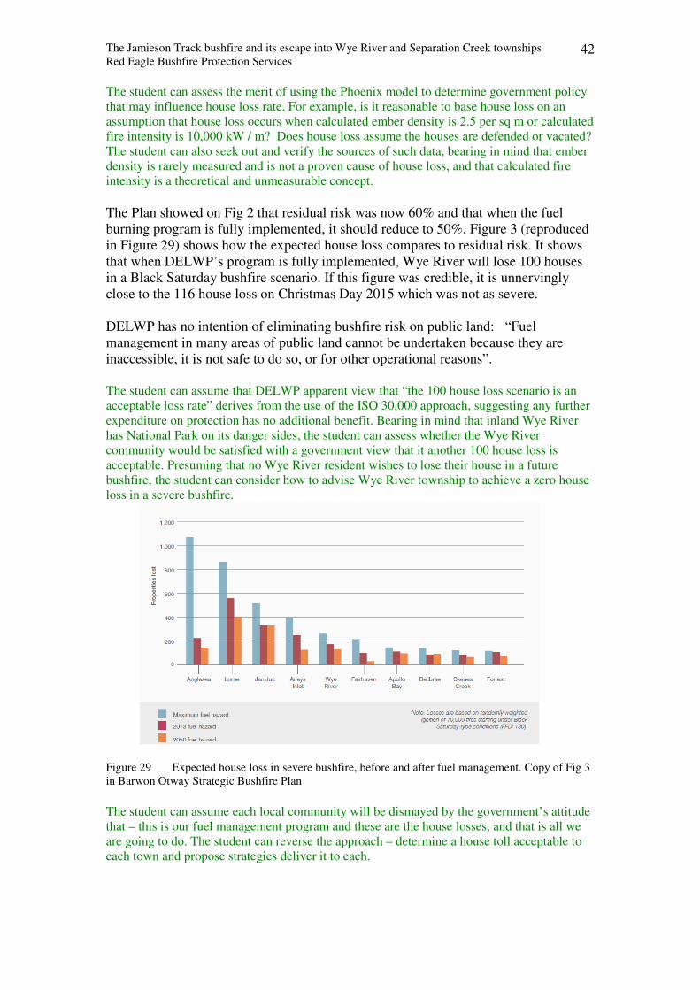
The Jamieson Track bushfire and its escape into Wye River and Separation Creek townships
Red Eagle Bushfire Protection Services 42
The student can assess the merit of using the Phoenix model to determine government policy
that may influence house loss rate. For example, is it reasonable to base house loss on an
assumption that house loss occurs when calculated ember density is 2.5 per sq m or calculated
fire intensity is 10,000 kW / m? Does house loss assume the houses are defended or vacated?
The student can also seek out and verify the sources of such data, bearing in mind that ember
density is rarely measured and is not a proven cause of house loss, and that calculated fire
intensity is a theoretical and unmeasurable concept.
The Plan showed on Fig 2 that residual risk was now 60% and that when the fuel
burning program is fully implemented, it should reduce to 50%. Figure 3 (reproduced
in Figure 29) shows how the expected house loss compares to residual risk. It shows
that when DELWP’s program is fully implemented, Wye River will lose 100 houses
in a Black Saturday bushfire scenario. If this figure was credible, it is unnervingly
close to the 116 house loss on Christmas Day 2015 which was not as severe.
DELWP has no intention of eliminating bushfire risk on public land: “Fuel
management in many areas of public land cannot be undertaken because they are
inaccessible, it is not safe to do so, or for other operational reasons”.
The student can assume that DELWP apparent view that “the 100 house loss scenario is an
acceptable loss rate” derives from the use of the ISO 30,000 approach, suggesting any further
expenditure on protection has no additional benefit. Bearing in mind that inland Wye River
has National Park on its danger sides, the student can assess whether the Wye River
community would be satisfied with a government view that it another 100 house loss is
acceptable. Presuming that no Wye River resident wishes to lose their house in a future
bushfire, the student can consider how to advise Wye River township to achieve a zero house
loss in a severe bushfire.
Figure 29 Expected house loss in severe bushfire, before and after fuel management. Copy of Fig 3
in Barwon Otway Strategic Bushfire Plan
The student can assume each local community will be dismayed by the government’s attitude
that – this is our fuel management program and these are the house losses, and that is all we
are going to do. The student can reverse the approach – determine a house toll acceptable to
each town and propose strategies deliver it to each.
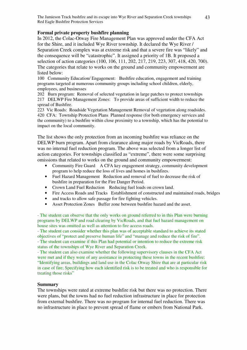
The Jamieson Track bushfire and its escape into Wye River and Separation Creek townships
Red Eagle Bushfire Protection Services 43
Formal private property bushfire planning
In 2012, the Colac-Otway Fire Management Plan was approved under the CFA Act
for the Shire, and it included Wye River township. It declared the Wye River /
Separation Creek complex was at extreme risk and that a severe fire was “likely” and
the consequence will be “catastrophic”. It assigned a priority of 1B. It proposed a
selection of action categories (100, 106, 111, 202, 217, 219, 223, 307, 418, 420, 700).
The categories that relate to works on the ground and community empowerment are
listed below: 100 Community Education/ Engagement: Bushfire education, engagement and training
programs targeted at numerous community groups including school children, elderly,
employees, and businesses
202 Burn program: Removal of selected vegetation in large patches to protect townships
217 DELWP Fire Management Zones: To provide areas of sufficient width to reduce the
spread of Bushfire.
223 Vic Roads: Roadside Vegetation Management Removal of vegetation along roadsides.
420 CFA: Township Protection Plans Planned response (for both emergency services and
the community) to a bushfire within close proximity to a township, which has the potential to
impact on the local community.
The list shows the only protection from an incoming bushfire was reliance on the
DELWP burn program. Apart from clearance along major roads by VicRoads, there
was no internal fuel reduction program. The above was selected from a longer list of
action categories. For townships classified as “extreme”, there were some surprising
omissions that related to works on the ground and community empowerment:
• Community Fire Guard A CFA key engagement strategy, community development
program to help reduce the loss of lives and homes in bushfires.
• Fuel Hazard Management Reduction and removal of fuel to decrease the risk of
bushfire in preparation for the Fire Danger Period.
• Crown Land Fuel Reduction Reducing fuel loads on crown land.
• Fire Access Roads and Tracks Establishment of constructed and maintained roads, bridges
• and tracks to allow safe passage for fire fighting vehicles.
• Asset Protection Zones Buffer zone between bushfire hazard and the asset.
- The student can observe that the only works on ground referred to in this Plan were burning
programs by DELWP and road clearing by VicRoads, and that fuel hazard management on
house sites was omitted as well as attention to fire access roads.
- The student can consider whether this plan was of acceptable standard to achieve its stated
objectives of “protect and preserve human life” and “manage and reduce the risk of fire”.
- The student can examine if this Plan had potential or intention to reduce the extreme risk
status of the townships of Wye River and Separation Creek.
- The student can also examine whether the following supervisory clauses in the CFA Act
were met and if they were of any assistance in protecting these towns in the recent bushfire:
“Identifying areas, buildings and land use in the Colac Otway Shire that are at particular risk
in case of fire; Specifying how each identified risk is to be treated and who is responsible for
treating those risks”
Summary
The townships were rated at extreme bushfire risk but there was no protection. There
were plans, but the towns had no fuel reduction infrastructure in place for protection
from external bushfire. There was no program for internal fuel reduction. There was
no infrastructure in place to prevent spread of flame or embers from National Park.
The Jamieson Track bushfire and its escape into Wye River and Separation Creek townships
Red Eagle Bushfire Protection Services 44
Chapter 7 House loss rate
House loss rate
The IGEM (2016) reported that 116 houses were destroyed, 18 in Separation Creek
and 98 in Wye River. In this bushfire attack, almost all residents were evacuated by
fire and emergency agencies. As discussed in Chapter 2, house loss rate in a bushfire
attack is influenced by both passive and active protection measures. In this case, the
influence of active protection is assumed to be minor. The IGEM noted that • Planning for evacuation and traffic management commenced on 21 December.
• All houses in the evacuation areas were door-knocked, and most residents chose to safely
evacuate.
• IGEM considers the evacuation strategy to be prudent, well planned and executed. It is an
example of leading practice for shared learning.
The fire authorities commissioned the CSIRO “to perform a review and commentary
of surviving and destroyed houses in Wye River and Separation Creek with the aim of
identifying factors that led to the loss, damage and survival of houses and to illustrate
these factors by citing examples from the fire footprint. Of particular interest are the
more recently constructed houses built under the Bushfire Management Overlay
(BMO) provisions”.
Even though the main focus was the influence of passive protection measures, the
CSIRO report mentions some evidence of water bombing and on-ground fire crew
activity, but was unable to assess the scale of suppression. Eye witness reports given
to me by local fire fighters and residents suggests that on-ground fire fighting was
patchy and in some cases was actively restricted by brigade captains and strike team
leaders due to the general perception of danger. There was evidence that no attempt
was made to stop the slow spread of the surface flame. Fire fighters on duty reported
watching it continue to progress through Wye River township during the early
morning (2 – 4 am) of the following day, igniting cars and houses almost 12 hours
after the first ember attack.
As this analysis proceeds, the student can assess the impact of evacuation in this bushfire
attack. By removing the opportunity for the occupant to defend their house, their house
survival now depended on the action of fire fighters. Were sufficient resources allocated to
cover their absence, or was the survival of their house put at risk by the evacuation policy?
The CSIRO report found there were 80 AS3959 planning referrals within Wye River
and Separation Creek since 2003, but only 21 had usable data, ie, they were fully
compliant - completed to occupancy and were exposed to bushfire attack. The CSIRO
report made these observations:
(1) They found 21 houses that were AS3959 compliant and of these, 7 were
destroyed, ie, house loss rate of fire resistant houses was 33%.
Further calculations reveal that 5% of the total house population (21/413) or 6.5% of
the Sep Ck / Wye north house population (21 / 321) were AS3959 compliant and 6%
of destroyed houses (6 / 116) were AS3959 compliant. This means there was no
significant difference in house loss rate between compliant and non compliant houses. Black Saturday data estimates were that 10% (8 – 12%) of the housing population was
AS3959 compliant that 9% of destroyed houses (177 / 2006) were AS3959 compliant. Again,
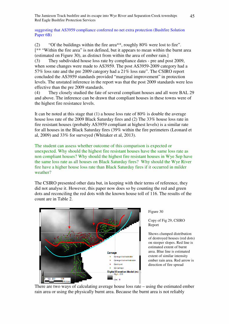
The Jamieson Track bushfire and its escape into Wye River and Separation Creek townships
Red Eagle Bushfire Protection Services 45
suggesting that AS3959 compliance conferred no net extra protection (Bushfire Solution
Paper 6B)
(2) “Of the buildings within the fire area**, roughly 80% were lost to fire”.
[** “Within the fire area” is not defined, but it appears to mean within the burnt area
(estimated on Figure 30), as distinct from within the area of ember rain.]
(3) They subdivided house loss rate by compliance dates - pre and post 2009,
when some changes were made to AS3959. The post AS3959-2009 category had a
57% loss rate and the pre 2009 category had a 21% loss rate”. The CSIRO report
concluded the AS3959 standards provided “marginal improvement” in protection
levels. The unstated inference in the report was that the post 2009 standards were less
effective than the pre 2009 standards.
(4) They closely studied the fate of several compliant houses and all were BAL 29
and above. The inference can be drawn that compliant houses in these towns were of
the highest fire resistance levels.
It can be noted at this stage that (1) a house loss rate of 80% is double the average
house loss rate of the 2009 Black Saturday fires and (2) The 33% house loss rate in
fire resistant houses (probably AS3959 compliant at highest levels) is a similar rate
for all houses in the Black Saturday fires (39% within the fire perimeters (Leonard et
al, 2009) and 33% for surveyed (Whitaker et al, 2013).
The student can assess whether outcome of this comparison is expected or
unexpected. Why should the highest fire resistant houses have the same loss rate as
non compliant houses? Why should the highest fire resistant houses in Wye Sep have
the same loss rate as all houses on Black Saturday fires? Why should the Wye River
fire have a higher house loss rate than Black Saturday fires if it occurred in milder
weather?
The CSIRO presented other data but, in keeping with their terms of reference, they
did not analyse it. However, this paper now does so by counting the red and green
dots and reconciling the red dots with the known house toll of 116. The results of the
count are in Table 2.
There are two ways of calculating average house loss rate – using the estimated ember
rain area or using the physically burnt area. Because the burnt area is not reliably
Figure 30
Copy of Fig 29, CSIRO
Report
Shows clumped distribution
of destroyed houses (red dots)
on steeper slopes. Red line is
estimated extent of burnt
area. Blue line is estimated
extent of similar intensity
ember rain area. Red arrow is
direction of fire spread
The Jamieson Track bushfire and its escape into Wye River and Separation Creek townships
Red Eagle Bushfire Protection Services 46
estimated from the line scans, because the method of bushfire attack was embers, and
because the location of the compliant houses is not known, the ember rain area is
chosen to enable comparison of like with like. Wye River south can be excluded from
the statistical analysis because of its greater distance from the ember source and zero
reported house loss. Assuming similar ember rain across Separation Creek and Wye
River north settlement, Table 2 shows that 321 houses (=120 + 201) were exposed to
bushfire attack. Therefore, average house loss rate was 36% (= 116/321).
Of the 21 houses that were AS3959 compliant with the highest fire resistance levels,
loss rate was 33% [7 destroyed / 21]. However, we can assume one quarter of the 21
houses were in Wye south area, the house loss rate of compliant houses within the
ember rain area (Figure 30) was 43% ( = 7 / 16).
Thus, there was either a negligible difference in house loss rate between the
populations of AS3959 compliant and non compliant houses or more statistically
likely, the AS3959 compliant houses had a significantly higher loss rate. This former
possibility is similar to the Black Saturday data averages, but there was one
significant difference, Wye River weather and fire behaviour was moderate whereas
Black Saturday was very severe.
The student can ponder the worth and efficacy of the AS3959 standards if houses constructed
to the highest fire resistance levels can have the same loss rate as non compliant houses in a
moderate ember attack where the maximum flame height was 0.4m.
Table 2 House numbers and house loss numbers derived from Figure 30 Number of dots
(approximates no. of
houses)
Separation
Creek
Wye River
(north of river)
Wye River
(south of river)
Total
Green dots 102 103 92 297
Red dots 18 98 0 116
Total dots 120 201 92 413
Estimated green dots
inside fire area**
4* 20* 0* 24*
Red dots inside fire
area**
18 79 97
Red dots outside fire
area**
0 19 19
* Destruction numbers are estimated from red dot ratio per location 18:98:0. Based on CSIRO estimate
of “80% house loss within fire area” [If 97 houses were destroyed within fire area, 24.5 were not
destroyed (= 97 (1 / 0.8 – 1) = 24.5].
** Fire area is defined as falling within CSIRO’s purple area in Figs 19 and 20. Note: even though the
burnt area is known to extend beyond the purple area, it can be considered as reasonable estimate.
Causes of house loss
The CSIRO report suggests there were four causes of house ignition – direct ignition
by embers, ignition by flame in surface fuel which was ignited by embers, and
ignition by flame in urban fuel that was either ignited by embers or ignited by flame
in surface fuel that was ignited by embers. The embers originated either in short
distance spotting from the nearby smoke mass or in medium distance spotting from up
to 1 km upwind.
The CSIRO report observed that steep slopes led residents to use sub floor spaces for
storage of flammable urban fuels, including domestic gas cylinders. These spaces
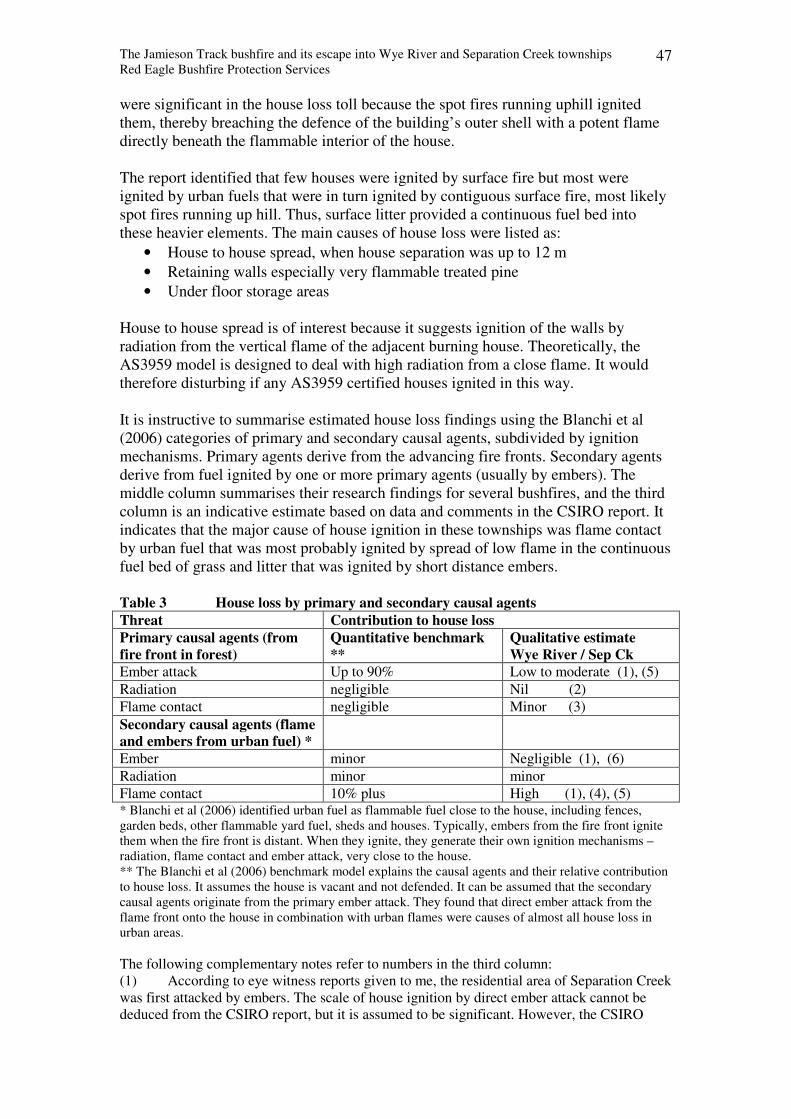
The Jamieson Track bushfire and its escape into Wye River and Separation Creek townships
Red Eagle Bushfire Protection Services 47
were significant in the house loss toll because the spot fires running uphill ignited
them, thereby breaching the defence of the building’s outer shell with a potent flame
directly beneath the flammable interior of the house.
The report identified that few houses were ignited by surface fire but most were
ignited by urban fuels that were in turn ignited by contiguous surface fire, most likely
spot fires running up hill. Thus, surface litter provided a continuous fuel bed into
these heavier elements. The main causes of house loss were listed as:
• House to house spread, when house separation was up to 12 m
• Retaining walls especially very flammable treated pine
• Under floor storage areas
House to house spread is of interest because it suggests ignition of the walls by
radiation from the vertical flame of the adjacent burning house. Theoretically, the
AS3959 model is designed to deal with high radiation from a close flame. It would
therefore disturbing if any AS3959 certified houses ignited in this way.
It is instructive to summarise estimated house loss findings using the Blanchi et al
(2006) categories of primary and secondary causal agents, subdivided by ignition
mechanisms. Primary agents derive from the advancing fire fronts. Secondary agents
derive from fuel ignited by one or more primary agents (usually by embers). The
middle column summarises their research findings for several bushfires, and the third
column is an indicative estimate based on data and comments in the CSIRO report. It
indicates that the major cause of house ignition in these townships was flame contact
by urban fuel that was most probably ignited by spread of low flame in the continuous
fuel bed of grass and litter that was ignited by short distance embers.
Table 3 House loss by primary and secondary causal agents
Threat Contribution to house loss
Primary causal agents (from
fire front in forest)
Quantitative benchmark
**
Qualitative estimate
Wye River / Sep Ck
Ember attack Up to 90% Low to moderate (1), (5)
Radiation negligible Nil (2)
Flame contact negligible Minor (3)
Secondary causal agents (flame
and embers from urban fuel) *
Ember minor Negligible (1), (6)
Radiation minor minor
Flame contact 10% plus High (1), (4), (5) * Blanchi et al (2006) identified urban fuel as flammable fuel close to the house, including fences,
garden beds, other flammable yard fuel, sheds and houses. Typically, embers from the fire front ignite
them when the fire front is distant. When they ignite, they generate their own ignition mechanisms –
radiation, flame contact and ember attack, very close to the house.
** The Blanchi et al (2006) benchmark model explains the causal agents and their relative contribution
to house loss. It assumes the house is vacant and not defended. It can be assumed that the secondary
causal agents originate from the primary ember attack. They found that direct ember attack from the
flame front onto the house in combination with urban flames were causes of almost all house loss in
urban areas.
The following complementary notes refer to numbers in the third column:
(1) According to eye witness reports given to me, the residential area of Separation Creek
was first attacked by embers. The scale of house ignition by direct ember attack cannot be
deduced from the CSIRO report, but it is assumed to be significant. However, the CSIRO
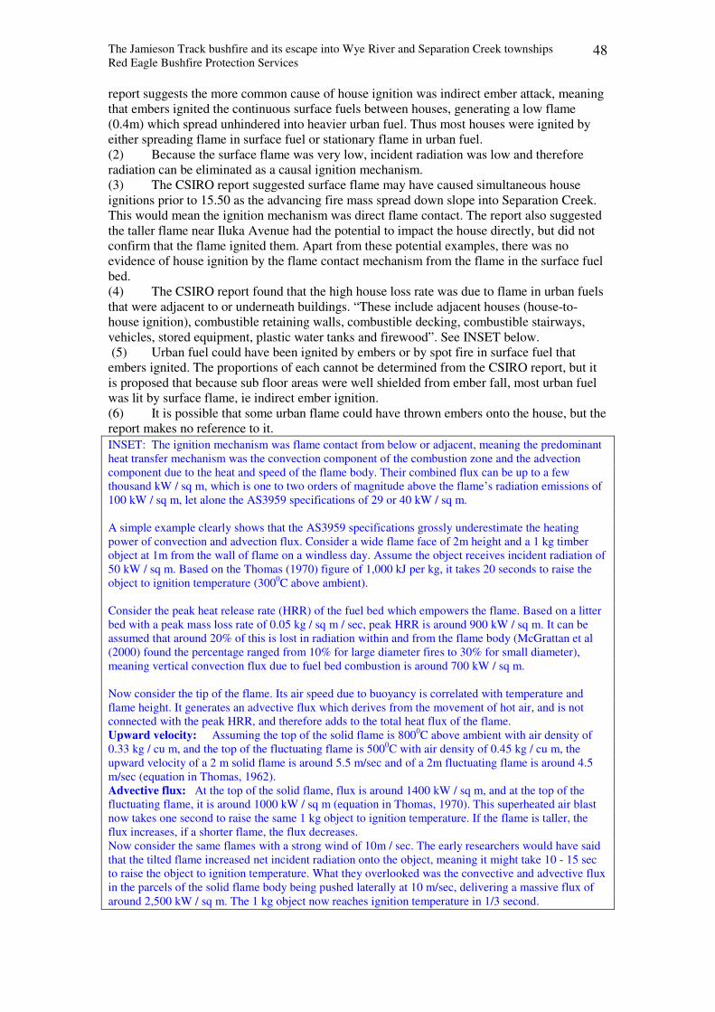
The Jamieson Track bushfire and its escape into Wye River and Separation Creek townships
Red Eagle Bushfire Protection Services 48
report suggests the more common cause of house ignition was indirect ember attack, meaning
that embers ignited the continuous surface fuels between houses, generating a low flame
(0.4m) which spread unhindered into heavier urban fuel. Thus most houses were ignited by
either spreading flame in surface fuel or stationary flame in urban fuel.
(2) Because the surface flame was very low, incident radiation was low and therefore
radiation can be eliminated as a causal ignition mechanism.
(3) The CSIRO report suggested surface flame may have caused simultaneous house
ignitions prior to 15.50 as the advancing fire mass spread down slope into Separation Creek.
This would mean the ignition mechanism was direct flame contact. The report also suggested
the taller flame near Iluka Avenue had the potential to impact the house directly, but did not
confirm that the flame ignited them. Apart from these potential examples, there was no
evidence of house ignition by the flame contact mechanism from the flame in the surface fuel
bed.
(4) The CSIRO report found that the high house loss rate was due to flame in urban fuels
that were adjacent to or underneath buildings. “These include adjacent houses (house-to-
house ignition), combustible retaining walls, combustible decking, combustible stairways,
vehicles, stored equipment, plastic water tanks and firewood”. See INSET below.
(5) Urban fuel could have been ignited by embers or by spot fire in surface fuel that
embers ignited. The proportions of each cannot be determined from the CSIRO report, but it
is proposed that because sub floor areas were well shielded from ember fall, most urban fuel
was lit by surface flame, ie indirect ember ignition.
(6) It is possible that some urban flame could have thrown embers onto the house, but the
report makes no reference to it. INSET: The ignition mechanism was flame contact from below or adjacent, meaning the predominant
heat transfer mechanism was the convection component of the combustion zone and the advection
component due to the heat and speed of the flame body. Their combined flux can be up to a few
thousand kW / sq m, which is one to two orders of magnitude above the flame’s radiation emissions of
100 kW / sq m, let alone the AS3959 specifications of 29 or 40 kW / sq m.
A simple example clearly shows that the AS3959 specifications grossly underestimate the heating
power of convection and advection flux. Consider a wide flame face of 2m height and a 1 kg timber
object at 1m from the wall of flame on a windless day. Assume the object receives incident radiation of
50 kW / sq m. Based on the Thomas (1970) figure of 1,000 kJ per kg, it takes 20 seconds to raise the
object to ignition temperature (3000C above ambient).
Consider the peak heat release rate (HRR) of the fuel bed which empowers the flame. Based on a litter
bed with a peak mass loss rate of 0.05 kg / sq m / sec, peak HRR is around 900 kW / sq m. It can be
assumed that around 20% of this is lost in radiation within and from the flame body (McGrattan et al
(2000) found the percentage ranged from 10% for large diameter fires to 30% for small diameter),
meaning vertical convection flux due to fuel bed combustion is around 700 kW / sq m.
Now consider the tip of the flame. Its air speed due to buoyancy is correlated with temperature and
flame height. It generates an advective flux which derives from the movement of hot air, and is not
connected with the peak HRR, and therefore adds to the total heat flux of the flame.
Upward velocity: Assuming the top of the solid flame is 8000C above ambient with air density of
0.33 kg / cu m, and the top of the fluctuating flame is 5000C with air density of 0.45 kg / cu m, the
upward velocity of a 2 m solid flame is around 5.5 m/sec and of a 2m fluctuating flame is around 4.5
m/sec (equation in Thomas, 1962).
Advective flux: At the top of the solid flame, flux is around 1400 kW / sq m, and at the top of the
fluctuating flame, it is around 1000 kW / sq m (equation in Thomas, 1970). This superheated air blast
now takes one second to raise the same 1 kg object to ignition temperature. If the flame is taller, the
flux increases, if a shorter flame, the flux decreases.
Now consider the same flames with a strong wind of 10m / sec. The early researchers would have said
that the tilted flame increased net incident radiation onto the object, meaning it might take 10 - 15 sec
to raise the object to ignition temperature. What they overlooked was the convective and advective flux
in the parcels of the solid flame body being pushed laterally at 10 m/sec, delivering a massive flux of
around 2,500 kW / sq m. The 1 kg object now reaches ignition temperature in 1/3 second.
The Jamieson Track bushfire and its escape into Wye River and Separation Creek townships
Red Eagle Bushfire Protection Services 49
But there is more. In addition to convective fluxes, when an object is impinged by a flame of
temperature T Kelvin, it also receives radiation in proportion to T4, which may be up to 200 kW / sq m
The student understands that the BAL level matches the heat flux of radiation from the flame
face in nearest vegetation. The highest level of resistance is around BAL 40, meaning it
theoretically prevents piloted ignition under radiation loads of 40 kW / sq m. The student can
now calculate the upward velocity and advective flux from the tip of a solid flame of 1m, 4m
and 10m tall.
The CSIRO report stated “It is clear that buildings built to the bushfire regulatory
standards … were subject to these heavy (domestic) fuels, and many were not capable
of withstanding the radiant heat or flame contact from these fuels. This appears to be a
key reason why such a large house loss rate was experienced”.
- The student can assess whether the AS3959 model caters for the flame of urban fuel, and if
not, why not, and how can it be amended to do so.
- The student will realise that protection by the AS3959 model depends entirely on preventing
flame penetration through the outer shell of the building. The CSIRO report mentions
flammable storage in the sub floor. Explain why the AS3959 model failed to prevent sub floor
flame penetration.
- The student can consider two aspects of the fire agencies’ BMO defendable space concept –
the specifications allow (1) fuel bed continuity and (2) low fuel load. This means if every
house in these townships was compliant with defendable space specifications, there would be
a continuous bed of low fuel load between the houses that if ignited, would generate a low
flame that would spread unchecked. The CSIRO report described that this exact scenario
occurred. How then can the student reconcile that this scenario, which was well within fire
authorities’ tolerance for BMO specifications, was declared as dangerous for fire fighters and
residents alike, and was also the cause of mass house loss?
Oblivious to the above findings that a low flame in a continuous fuel bed was the
source of catastrophic house loss of highly fire resistant houses compliant with the
regulations, the fire authorities and other government agencies have persisted with
current planning law. The next chapter examines the problematic logic and the
science behind these laws and tries to assess their effectiveness. It clarifies how the
laws are supposed to work. But then we discover a twist. Have the authorities thrown
out the rule book and are now inflicting the house loss victims with another burden
they do not need?
Summary
House loss rate The average house loss rate within the fire area was 80%.
The average house loss rate within the ember rain area was 33%. The average house
loss rate of AS3959 compliant houses was at least 33%, and probably around 43%.
Thus there was either a negligible difference in house loss rate between the
populations of AS3959 compliant and non compliant houses or more likely, the
AS3959 compliant houses had a significantly higher loss rate.
Causes of house loss: Some houses were directly ignited by embers (via
accumulations of fine dry flammable fuel in gutters, roofs and adjacent to walls), but
most were ignited by flame in urban fuels that were ignited by low flame in
contiguous surface fuel bed, most likely spot fires running up hill, which were in turn
ignited by live embers originating from a few hundred metres to 1 km upwind.
Continuous surface fuel bed of litter / grass provided an uninterrupted pathway to the
flammable urban fuels. Few houses were ignited directly by flame in surface fuel bed.
The Jamieson Track bushfire and its escape into Wye River and Separation Creek townships
Red Eagle Bushfire Protection Services 50
Chapter 8 Rebuilding the burnt houses
Current planning legislation for new house construction under the Bushfire
Management Overlay can be summarised in PPN 65 as follows. For an allotment
within residential and township zones, as these destroyed houses were, Clause 52.47.1
applies. A site assessment and a bushfire management statement are required whereas
a landscape assessment is not. Clause 52.47.2 applies to new house construction in
other planning zones and it also applies to subdivisions, requiring documentation in
all three categories - site assessment, landscape assessment and a bushfire
management statement. For both Clauses, BAL level derives from distance between
house site and the deemed hazard. Separation distance becomes defendable space.
PPN 65 gives an example of the inverse correlation between the two - “the greater
separation distance between the bushfire hazard and the proposed building, the lower
the bushfire risk and construction cost.” In the case of subdivisions, Clause 52.47.2 is
applied to groups of allotments by requiring that the building envelope on each
allotment meets individual defendable space and BAL requirements, and to ensure
implementation, a Section 173 agreement is inserted on each title.
The point to make here is that the government has established a set of rules and the
last thing we would expect is what they have changed them for the house loss victims
in these towns. But it has. In principle, a change that streamlines the bureaucratic
processes should be welcomed. Unfortunately it will increase the financial burden of
bushfire victims by inflating BAL levels well above the existing set of rules.
To understand how the rule changes inflate BAL levels beyond current laws and why
the changes are ill founded and add no additional protection, the current laws are now
outlined together with their flaws of logic, science and threat management.
Current planning laws for building new houses
It is public policy that a new house within a BMO area is deemed to be protected from
ignition by severe bushfire when its AS3959 derived construction design rating
(Bushfire Attack Level - BAL) matches the calculated radiation from a wall of flame
in the fire front in accordance with the procedure and equations in AS3959. Severe
bushfire is defined as tall flame in the nearest vegetation to the new house, and its
separation distance becomes defendable space which determines the BAL. Thus,
planning law implies that BAL ranks the bushfire threat level to the new house site
and it is mitigated when (1) construction complies with that BAL and (2) defendable
space maintained according to AS3959 specifications. The specifications include low
fuel load on the ground within defendable space, which means authorities regard a
low flame height as acceptable. They have no specifications about discontinuity of
fuel load.
Outline of the AS3959 model The AS3959 model identifies a bushfire threat to the house, quantifies it and provides a
means of mitigation in proportion to the level of the threat.
Overview
The narrative of the model can be deduced as follows:
Identify the threat:
The Jamieson Track bushfire and its escape into Wye River and Separation Creek townships
Red Eagle Bushfire Protection Services 51
The threat is rapid piloted ignition of the outer shell of the house. The source of the threat is
the fire front which is deemed to occur in the nearest vegetation to the house site within 100m
radius. This fire front generates flame, radiation and embers, and the closer the vegetation is
to the house, the higher the level of radiation** and “risk of ember attack” and flame contact
at the house site. The threat level is quantified as the maximum radiation level received on the
house wall from the tallest possible flame in the nearest vegetation. (The vegetation is
assumed to be at maximum fuel load and to generate a flame which is 100m wide and of two
minutes duration with a height calculated by AS3959 equations. See below). The threat level
is classified as Bushfire Attack Level or BAL. It ranges from 12.5 to 40+, reflecting incident
radiation levels of 12.5 to 40+ kW / sq m. ** Technically, higher radiation means construction materials ignite faster. The model assumes
radiation from the flame face lasts for 2 minutes, which means if high heat flux causes ignition time is
less than two minutes, the highest BAL 40 design will ignite.
Mitigate the threat: Each element of the building’s outer shell is identified and the component materials are
assessed for resistance to ignition at each threat level. This allows fire resistance of building
materials to be graded to match that threat level. For each BAL, the AS3959 model presents a
package of construction specifications whose component materials have been tested in the lab
to resist ignition at that BAL. Thus the AS3959 model deems that if a house site occurs where
the threat level is assessed at BAL 29, building the house with the materials specified in the
BAL 29 package will mitigate the bushfire threat.
NOTE: no other ignition source is contemplated, eg, fine fuel build-up on or near the house,
cracks or surface roughness in materials, flame from close urban fuel.
Detail
Calculating the threat level:
The AS3959 procedure is firstly to identify the nearest vegetation within 100m of the
proposed house site, then to measure the horizontal distance between house and vegetation
and then to assume that this vegetation is the fire front. The fire front has a defined width of
100m and the AS3959 equations calculate the tallest possible flame height in it. This wall of
flame radiates onto the house site with a level between 12 and around 50 kW / sq m. This
flame also generates the embers that fall onto the house. The closer the vegetation is to the
house, the higher is the radiation level and risk of ember attack.
Equations for calculating flame height:
After identifying the vegetation type with AS3959’s ecological vegetation classes within
100m of the house site, AS3959 defines each vegetation type with a maximum fuel load (W).
It defines weather as 400C, 12% RH and wind speed 40 kph.
The following equations are used for forest and woodland vegetation.
(F1) Calculate rate of spread (R) with R = 0.0012 x FDI x W,
(F2) Adjust rate of spread for slope with Rslope = R x exp (0.069 x slope)
(F3) Calculate flame length (Z) with Z = (13 x Rslope + 0.24 x W) / 2
(F4) Calculate radiation from flame length using View Factor equations, assuming the flame
face is 100m wide flame front and emitting radiation at 100 kW / sq m.
The following equations are used for shrub or scrub vegetation
(S1) Calculate rate of spread R = 0.023 x wind^1.21 x veg height^0.54
(S2) Adjust rate of spread for slope with Rslope = R x exp (0.069 x slope)
(S3) Calculate Byram’s Fireline Intensity - BFI = H x fuel load x Rslope
(S4) Calculate flame length with Lf = 0.0775 x BFI^0.46
(S5) Calculate radiation from flame length using View Factor equations, assuming the flame
face is 100m wide flame front and emitting radiation at 100 kW / sq m.
The Jamieson Track bushfire and its escape into Wye River and Separation Creek townships
Red Eagle Bushfire Protection Services 52
Summary: The perceived AS3959 threat is piloted ignition of the house by a fire front in the nearest
vegetation deemed to be at highest fuel load.
The ingredients of piloted ignition are heat and pilot flame, and this fire front delivers them
with flame, radiation and embers.
The closer the vegetation is to the house, the higher the radiation level, which means the
faster the construction materials ignite.
Ignition of construction materials is prevented at any radiation level by using AS3959
materials whose fire resistance has been tested against that level.
Evaluation of AS3959 as a proxy for assessing and mitigating threat of house loss
Assessing threat of house loss 1 The AS3959 model assumes radiation is the major cause of house loss in a severe
bushfire.
In reality, radiation is a negligible cause of house loss. The overwhelming causes are ember
attack onto the house and urban flame from urban fuel that embers have ignited. Thus, the
AS3959 package is designed to treat a threat that is insignificant.
2 AS3959 assumes piloted ignition from the fire front is the major cause of house loss.
Piloted ignition (also called hot ignition) is preheating the surface to vapourise the volatile
gases and providing a spark to ignite them. In a bushfire, piloted ignition occurs when the fire
front is very close to the house.
In reality, the fire front rarely reaches the destroyed house. Most houses are ignited by embers
when the source fire is not close. When these embers ignite the house, the mechanism is “cold
ignition”.
The student asks - why can’t the AS3959 model protect these houses from “cold ignition”? If
the nearest classified vegetation is at a distance, the BAL is low (or 12.5 in Victoria), meaning
it provides some ember protection to the building shell by gap size restriction, but because it
assumes there is no fuel threat other than the tested building materials, it ignores flammable
fuel sites in and adjacent to the house, eg, dead leaves in gutters and roof valleys, dead grass
or mulched garden beds against walls, or fences. A low BAL also means that the external
shell has materials of lower fire resistance. Therefore, if embers ignite and the spot fires grow,
their flames can ignite flammable bits of external building materials by flame contact or crack
windows and allow flame entry. Thus AS3959 is designed to protect specified building
materials on the building shell from piloted ignition, but assumes the many other flammable
things in, on, under and near the house do not exist. Because the flames from the peripheral
materials have heat fluxes that are one to two orders of magnitude higher than even the
highest BAL’s, AS3959 compliance levels provide no resistance to rapid ignition.
3 AS3959 assumes there is no threat to the house from beyond 100 m radius. It assumes
the only threat comes from the nearest vegetation patch because the fire front occurs there and
it generates all the radiation, flame and embers that fall onto the house.
In reality, embers can source from any distance upwind or down-hill from the house site. In a
severe bushfire, they occur in very high density within 500m of an established fire front in a
forest, and at reducing density as distance increases. If these embers ignite the house, the
mechanism is “cold ignition”.
The student asks - why can’t the AS3959 model protect these houses from “cold ignition”?
See above answer
4 AS3959 assumes there is a main fire front and that it passes over the house site.
In reality, a severe bushfire in a forested landscape is a multitude of spot fires of varying size,
running in parallel and leap frogging independently across the landscape generating short,
The Jamieson Track bushfire and its escape into Wye River and Separation Creek townships
Red Eagle Bushfire Protection Services 53
medium and long distance spotting simultaneously. This is why the first bushfire element to
attack a house is the ember, when the source flame is not within sight.
The student asks - why can’t the AS3959 model protect these houses from “cold ignition”?
See above answer
5 AS3959 assumes the nearest vegetation ignites to become the fire front.
In reality, the nearest vegetation can only become the fire front if it is downwind of the
advancing flame and upwind or down hill from the house site. If we assume the danger side is
between N and SW, only 1/3 of the nearest “classified vegetation” can become a threat to the
house site. Neither AS3959 not the fire authorities recognise direction in the planning laws
and require such house sites to have a BAL based purely on distance to nearest vegetation.
6 AS3959 assumes the fire front does not come closer than the nearest vegetation
In the AS3959 model, BAL is calculated from distance to nearest vegetation. AS3959
assumes the flame stops at the nearest vegetation and uses it to calculate radiation levels onto
the house. Meanwhile, the fire authorities deem this distance as defendable space and assign it
with fuel load specifications that reduce the flame height near the house and presumably
make it safe for fire fighters that may come to extinguish the house. Thus, fire authorities
allow a low flame into defendable space, whereas AS3959 magically keeps it fuel free.
7 Equations used to calculate deemed flame height in deemed fuel hazard are not only
invalid but are used in ways that breach bushfire behaviour science theory and principles.
The process of calculating flame height from rate of spread is scientifically untenable because
there is no evidence or logic supporting a causal correlation between the two. For example,
equation (F1) is based on an equation that was disproven several years ago, and equation (F3)
is an unverified variation of an equation that was also disproven several years ago.
Mitigating threat of house loss
8 AS3959 considers only one way to mitigate the assumed threat, ie, protect the new
building from ignition. Australian Standards is not responsible for how fire authorities use its
AS3959 system as a unilateral solution for new houses.
The fire authorities evidently agreed strongly with the AS3959 approach for the new house
because it is the only method that they use and they require it to be done by law. Even though
new houses are usually interspersed among existing houses, and they may encourage existing
house owner to retro-fit according to BAL construction standards, they have no legally
enforceable program to protect individual existing houses against the same assumed threat.
In reality, there are at least two options to mitigate a real or a deemed threat – make the house
builder protect the house from the threat or make the owner of the hazard mitigate the threat
to protect the neighbourhood. The latter approach is the common law / duty of care approach
for dealing with a threat in a neighbourhood, whereas the fire agency approach of making the
house fire resistant is a reversal of duty of care protocols.
Fire authorities have an incongruous approach to community protection even though they are
legally responsible for providing prevention and suppression services. They identify the
nearest vegetation to a new house site as a deemed threat, but there is no process to reduce the
threat, nor to advise the owner of the threat’s danger and his duty to mitigate it, nor to warn
surrounding residents of the threat’s existence. Instead, the authorities almost secretly require
owner of the new house to pay tens of thousands dollars more for self protection and the
deemed threat remains in place. Because the owner of the hazard is not required to mitigate
the hazard, the whole neighbourhood remains threatened by the deemed threat in perpetuity.
That is the case if the nearest vegetation is a real hazard of legitimate concern. If it is a real
threat, and the fire authorities leave it unmitigated when they have the powers to mitigate,
they can be accused of abrogation of their legal obligations. If it is not a real threat, they can
The Jamieson Track bushfire and its escape into Wye River and Separation Creek townships
Red Eagle Bushfire Protection Services 54
be accused of unfairly penalising the new house builder to pay unnecessarily for a non
existent threat. Either way, their incongruous approach is inadequate.
The student can consider if their one eyed determination to force individual new houses to
build according to AS3959 construction standards at inflated prices has blinded them to
community wide bushfire protection by using much more effective and efficient methods?
9 The AS3959 process of maximising flame height may have suited its purposes of a
built-in safety factor, but its rigid application by fire authorities precludes any prospect of
encouraging mitigation of a fuel hazard.
Fire authorities’ requirement that new houses have maximum fire resistance and their lack of
desire to mitigate the deemed hazard ensures it remains intact. If it is a true hazard, as some
are, all incentive for the house builder and neighbours to encourage the owner of the hazard to
mitigate it is removed.
10 If the AS3959 model was effective, house loss statistics would show that AS3959 or
BMO compliant houses have a lower house loss rate than non compliant houses in the same
bushfire attack.
Pre 2009 research found the major influence on house loss rate was whether the house was
defended or undefended. The house loss rate of defended houses was one sixth of undefended
houses. The 2009 bushfires destroyed 2000 houses. The VBRC was told by the fire
authorities and building authorities there was no evidence that the AS3959 compliance
systems reduced house loss rate. I analysed the data presented to VBRC and found that there
was no difference in house loss rate between the compliant and the not compliant. One
bushfire averaged 9% for both. One town averaged 85+% for both. I analysed CSIRO data
from the Wye River bushfire’s 116 house toll and found the house loss rate the compliant and
the not compliant were the same at around 33%.
Thus, there is no evidence that AS3959 model reduces house loss rate in severe or non severe
bushfires.
Warning note: There was one unexpected and worrying loss rate within the VBRC data. Life
loss rate was three times higher in compliant houses that non compliant. Indeed evidence
taken by the VBRC supported the view that people saw compliant houses as safer and
desperately sought their final shelter in them.
Summary: The AS3959 package cannot be regarded as a proxy for assessing risk of house loss because
its assumptions do not align with reality:
The AS3959 package focuses on radiation, but in reality it is a negligible cause of house loss.
AS3959 regards the threat to the house is ignition under heat from the fire front, but in reality
the fire front is rarely near the house at time of ignition.
AS3959 assumes there is negligible threat to the house from beyond 100m, but in reality it is
the source of most threat.
AS3959 assumes the fire front passes over the house, but in reality, a main fire front does not
exist
AS3959 assumes the threat is the nearest vegetation, but in reality up to 2/3 of closest
vegetation is not excluded because it is not on the danger side.
AS3959 assumes the fire stops at the edge of nearest vegetation, but in reality, fire authorities
allow low flame to run up to the house site.
Equations used to calculate deemed flame height are invalid and used unscientifically
The AS3959 package cannot be a proxy for mitigating risk of house loss because:
AS3959 was not intended to indicate risk of house loss because it proposes only one solution
for a specifically designed threat to the new house, yet the fire authorities apply it without
supplementing it with other threats or solutions and with no regard for protecting existing
houses from the deemed AS3959 threat.

The Jamieson Track bushfire and its escape into Wye River and Separation Creek townships
Red Eagle Bushfire Protection Services 55
The AS3959 concept of maximum flame height is copied by fire authorities and the result is
that incentive to mitigate a true hazard is precluded
Available post fire data shows AS3959 compliant houses have the same house loss rate as non
compliant houses
Changing the rules
Sequence On 10 March, unbeknown to the local burnt out community, a document (“Wye River
and Separation Creek bushfire affected properties (March, 2016)”) was submitted to the
Minister to amend the local planning scheme, but it was not subjected to public
exhibition. It was approved under “Minister Intervention” powers on 31 March and
the planning scheme was duly amended - Amendment C089 - by adding this
“incorporated document” to Schedule of Clause 81.01. One main purpose was to
“specify bushfire attack levels for the purpose of regulation 811(1) of the Building
Regulations 2006”. These levels were referenced to a government map “The Wye River
and Separation Creek bushfire attack level GIS data 2016 (Department of Environment,
Land, Water and Planning)”. The section below reveals that these bushfire attack levels
are different from the levels referred to in the Building Regulations. To differentiate
each in this report, the AS3959 levels will be referred to as BAL’s and the
government revised levels will be referred to as the DTBAL’s.
On 31 March, the government authorities’ Fact Sheet (2016) notified the residents http://wyesepconnect.info/Fact%20Sheets/Fact%20Sheet%20Bushfire%20Attack%20Level%20final_3
10316.pdf
of Wye River and Separation Creek who suffered house loss that their property had
been pre-classified at a specific DTBAL, and that if they comply with the streamlined
process, their rebuilding application can be done much more smoothly than if they
proceed through the process as required by current planning law. It made no mention
of changes made to planning laws via Amendment C089.
On 5 April 2016, the community was advised of an amendment to planning scheme –http://wyesepconnect.info/minister-planning-approves-planning-amendment/.
The notification stated: “the settlement wide (DT)BAL reflects the shared responsibility of
individual landowners in reducing bushfire risk to enhance community safety”.
On 8 April, 2016 the local peak community group expressed major concerns: Message from Community Representatives on the Wye River and Separation Creek Community
Resilience Committee: We are dismayed and disappointed by the Minister for Planning’s unilateral
determination on such an important community issue. The Minister’s determination to restrict appeals
against (DT)BAL ratings has not considered all the evidence and removes the basic right to
independent review of a decision that could detrimentally affect the viability of hundreds of properties
in Wye River and Separation Creek. There has been no adequate consultation to date about the BAL
rating process with the community of Wye River and Separation Creek.
http://wyesepconnect.info/minister-planning-approves-planning-amendment/
To summarise so far, Amendment C089 was approved in March and the public was
advised in April. Two key supporting documents (Terramatrix and CSIRO) were
released later and both were dated after March, suggesting their contents may not
have been fully considered during the March approval process. For example, when the
Terramatrix report, dated April 2016, was released, it revealed that the DELWP
bushfire attack level map was derived from the Terramatrix report, and that the
methodology to derive their DTBAL’s was very different to the AS3959 method of
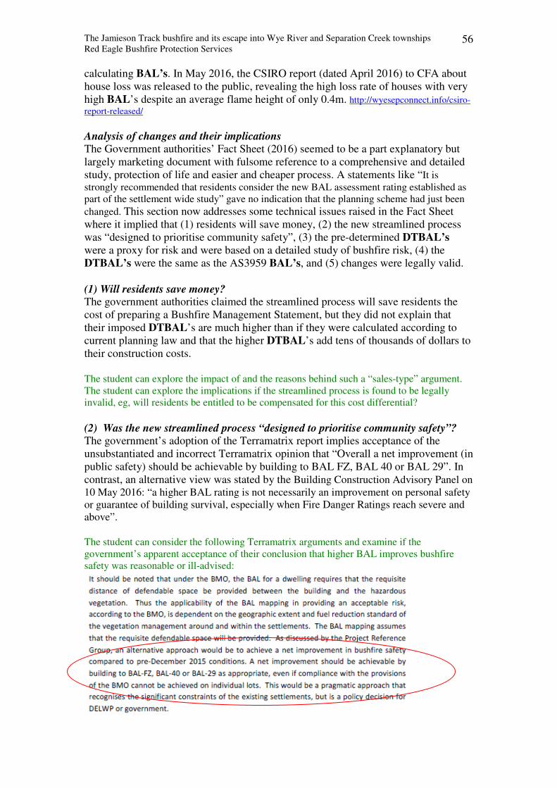
The Jamieson Track bushfire and its escape into Wye River and Separation Creek townships
Red Eagle Bushfire Protection Services 56
calculating BAL’s. In May 2016, the CSIRO report (dated April 2016) to CFA about
house loss was released to the public, revealing the high loss rate of houses with very
high BAL’s despite an average flame height of only 0.4m. http://wyesepconnect.info/csiro-
report-released/
Analysis of changes and their implications The Government authorities’ Fact Sheet (2016) seemed to be a part explanatory but
largely marketing document with fulsome reference to a comprehensive and detailed
study, protection of life and easier and cheaper process. A statements like “It is
strongly recommended that residents consider the new BAL assessment rating established as
part of the settlement wide study” gave no indication that the planning scheme had just been
changed. This section now addresses some technical issues raised in the Fact Sheet
where it implied that (1) residents will save money, (2) the new streamlined process
was “designed to prioritise community safety”, (3) the pre-determined DTBAL’s
were a proxy for risk and were based on a detailed study of bushfire risk, (4) the
DTBAL’s were the same as the AS3959 BAL’s, and (5) changes were legally valid.
(1) Will residents save money? The government authorities claimed the streamlined process will save residents the
cost of preparing a Bushfire Management Statement, but they did not explain that
their imposed DTBAL’s are much higher than if they were calculated according to
current planning law and that the higher DTBAL’s add tens of thousands of dollars to
their construction costs.
The student can explore the impact of and the reasons behind such a “sales-type” argument.
The student can explore the implications if the streamlined process is found to be legally
invalid, eg, will residents be entitled to be compensated for this cost differential?
(2) Was the new streamlined process “designed to prioritise community safety”? The government’s adoption of the Terramatrix report implies acceptance of the
unsubstantiated and incorrect Terramatrix opinion that “Overall a net improvement (in
public safety) should be achievable by building to BAL FZ, BAL 40 or BAL 29”. In
contrast, an alternative view was stated by the Building Construction Advisory Panel on
10 May 2016: “a higher BAL rating is not necessarily an improvement on personal safety
or guarantee of building survival, especially when Fire Danger Ratings reach severe and
above”. The student can consider the following Terramatrix arguments and examine if the
government’s apparent acceptance of their conclusion that higher BAL improves bushfire
safety was reasonable or ill-advised:
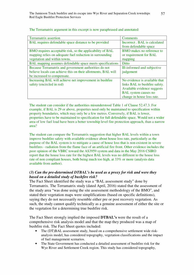
The Jamieson Track bushfire and its escape into Wye River and Separation Creek townships
Red Eagle Bushfire Protection Services 57
The Terramatrix argument in this excerpt is now paraphrased and annotated:
Terramatrix assertion Comments
BAL requires defendable space distance to be provided Incorrect . BAL is calculated
from defendable space
BMO requires acceptable risk, so the applicability of BAL
mapping relies on adequate fuel reduction in surrounding
vegetation and within towns.
BMO makes no reference to
or requirement for BAL
mapping
BAL mapping assumes defendable space meets specifications Ditto
Because Terramatrix and government authorities do not
believe locals can achieve this on their allotments, BAL will
be increased to compensate.
Ill-informed and subjective
judgement
Increasing BAL will achieve net improvement in bushfire
safety (encircled in red)
No evidence is available that
links BAL to bushfire safety.
Available evidence suggests
BAL system causes no
change in house loss rate.
The student can consider if the authorities misunderstood Table 1 of Clause 52.47.3. For
example, if BAL is 29 or above, properties need only be maintained to specification within
property boundaries, which may only be a few metres. Conversely, if BAL is lower,
properties have to be maintained to specification for full defendable space. Would not a wider
area of low fuel load have been a better township level fire protection approach, than a narrow
area?
The student can compare the Terramatrix suggestion that higher BAL levels within a town
improve bushfire safety with available evidence about house loss rate, particularly as the
purpose of the BAL system is to mitigate a cause of house loss that is non existent in severe
bushfires - radiation from the flame face of an artificial fire front. Other evidence includes the
poor opinion of the VBRC toward the AS3959 system and data in the May 2016 CSIRO
report that the house loss rate for the highest BAL levels was no different to the house loss
rate of non compliant houses, both being much too high, at 33% or more (analysis data
available from author).
(3) Can the pre-determined DTBAL’s be used as a proxy for risk and were they
based on a detailed study of bushfire risk? The Fact Sheet identified the study was a “BAL assessment study” done by
Terramatrix. The Terramatrix study (dated April, 2016) stated that the assessment of
the study area “was done using the site assessment methodology of the BMO”, and
stated their vegetation maps were simplifications (based on specific definitions),
saying they do not necessarily resemble either pre or post recovery vegetation. As
such, the study cannot qualify technically as a genuine assessment of either the site or
the vegetation for a determining true bushfire risk.
The Fact Sheet strongly implied the imposed DTBAL’s were the result of a
comprehensive risk analysis model and that the map they produced was a map of
bushfire risk. The Fact Sheet quotes included:
• The (DT)BAL assessment study, based on a comprehensive settlement wide risk-
analysis model, has considered topography, vegetation classifications and the impact
of fuel management scenarios.
• The State Government has conducted a detailed assessment of bushfire risk for the
Wye River and Settlement Creek region. This study has considered topography,
The Jamieson Track bushfire and its escape into Wye River and Separation Creek townships
Red Eagle Bushfire Protection Services 58
vegetation classifications and the impact of fuel management scenarios on the
severity of a building’s potential exposure to ember attack, radiant heat and direct
flame contact.
• The government and Council have partnered to map the bushfire risk — known as
'Bushfire Attack Levels' — in the impacted areas of Wye River and Separation Creek.
• The assessments have been completed in accordance with the finding of the 2009
Victorian Bushfires Royal Commission.
• This study is based on a comprehensive settlement wide risk-analysis model that aims
to minimise bushfire risk. This assessment is designed to prioritise community safety,
liveability and drive community resilience to bushfires.
The student can consider the following responses to these quotes:
• To imply that the AS3959 BAL or the DTBAL is based on a comprehensive risk
analysis model is a gross misrepresentation. The AS3959 BAL derives from
defendable space, which is the distance between the house site and nearest vegetation.
• The DELWP map of “bushfire risk” was done by a private company Terramatrix, not
by government, and it was technically a DTBAL map calculated using Terramatrix
innovative methods and opinions. Their package was accepted by government.
• To state that the State Government has conducted a detailed assessment of bushfire
risk for the Wye River and Settlement Creek region is a misrepresentation because
the Terramatrix study was entitled “BAL assessment study”.
• To suggest that bushfire risk is associated with AS3959 BAL is a gross
misrepresentation of both BAL and bushfire risk. BAL measures theoretical radiation
onto the house from an artificially inflated flame in the nearest vegetation, but
because approx 2/3 of nearest vegetation is on the non danger side and because
radiation is a negligible cause of house loss in a severe bushfire, BAL has no
correlation to either bushfire risk or risk of house loss. The Terramatrix method of
calculating DTBAL is very different to AS3959 method, and because it is based on
radiation levels and subjective opinion of residents’ future maintenance failings, it
has even less correlation to either bushfire risk or risk of house loss.
• To state the assessment complies with the Royal Commission findings is bizarre
because the VBRC was very critical of the AS3959 model and besides, the
assessment method for DTBAL would have been foreign to VBRC.
• To claim that the AS3959 BAL risk model aims to minimise risk is a gross
misrepresentation. If they believe BAL is a measure of bushfire risk, to reduce risk
means BAL must be reduced. But because BAL is based on distance to nearest
vegetation which is unchangeable, risk level cannot be reduced unless the vegetation
is removed.
Nevertheless, the government authorities seem to have adopted a view that the
concept of BAL or DTBAL is a universal measure of bushfire risk, when it is not.
Terramatrix seem to believe BAL and DTBAL are a universal measure of bushfire
risk. Appendix 1 of their report summarised their approach to an earlier assessment of
bushfire risk at eight towns in the Otways. They conducted two levels of risk
assessment, landscape risk and BAL mapping. For BAL mapping, they innovated by
changing the procedure of AS3959. Instead of calculating BAL after measuring
defendable space and slope, they calculated radiation from the forest boundary using
maximum fuel load and then assumed that all allotments within the settlement would
also have high radiation levels. Their map of Wye River and Separation Creek
showed almost all allotments had very high DTBAL. If they had used the AS3959
procedure, the very high DTBAL allotments would have been restricted to 25 metres
or so from each upslope forest boundary.
The Jamieson Track bushfire and its escape into Wye River and Separation Creek townships
Red Eagle Bushfire Protection Services 59
Using AS3959 BAL as a measure of bushfire risk is to extrapolate AS3959 well
beyond its design criteria, which targets only one threat. Its stated objective is to
reduce risk of piloted ignition by the fire front which resides in the nearest vegetation.
Because BAL is based solely on distance between house and vegetation, the only way
that AS3959 risk of ignition changes is when the distance between the house site and
vegetation changes. Therefore, technically the AS3959 concept of risk can only be
applied to an area where a house exists, where the nearest classified vegetation is
within 100m of it, and where the fire front sweeps into and consumes the nearest
classified vegetation which showers radiation and embers onto the house and menaces
the house with one threat - piloted ignition, and then continues past the house site.
Because such a scenario is rare in Victoria, AS3959 cannot be validly extrapolated as
a measure of bushfire risk.
Ironically, a few edges of the Wye River and Separation Creek towns almost met the
AS3959 concept, except that house ignition was caused by a different threat - flame
contact with convective fluxes that exceeded BAL levels by one to two orders of
magnitude. The CSIRO report found that most house loss occurred when urban fuel
was ignited by free running low flames between the houses. These and other flame
sources are not envisaged by AS3959, which assumes the flame stops at the edge of
nearest classified vegetation. When authorities adopted the AS3959 system, they
defined the separation distance between house site and vegetation as defendable space
and allowed continuous low fuel load within it, which meant they tolerated low flame
within defendable space. Theoretically, the AS3959 model could work if all houses
had defendable space that was fuel free, but it would have been undermined by the
fire authorities’ acceptance of continuous low fuel load within defendable space.
The student can assume that the Terramatrix report correctly transcribes AS3959 Appendix G
into its Table 1 (p 19) and the CFA diagram into its Fig 2, and that both accurately show the
context of AS3959, ie, that it regards the nearest “classified vegetation” as the fire front and
as the sole source of radiation, flame contact and embers. The student will understand that the
Terramatrix Table and the diagram describe an increasing radiation level as the AS3959 flame
front gets closer to the house, complete with increasing risk of ember attack, ignition of
burning debris and flame contact, and that this means the speed of the main AS3959 threat of
piloted ignition will also increase. The student can assess whether the BAL’s of AS3959
model can be extrapolated as a universal measure of bushfire risk when it is a single focused
threat model and if house loss by this threat is negligible.
(4) Were pre-determined DTBAL’s the same as the BAL’s of AS3959 / BMO? Although both systems determine the threat to a property and assign a mitigation
mechanism, the methods and processes are very different.
- The AS3959 model uses a published process to determine the BAL onto an
individual house site (= the BAL of the threat) and then assigns a construction
standard of the same level to mitigate the threat (= the BAL construction standard).
- The Terramatrix model determines a perceived threat level for each broad vegetation
zone (eg, peak radiation level for forest and scrub and a subjective judgement for Mod
Veg and Low Threat) and then assigns a construction standard BAL to mitigate the
threat to all allotments within each vegetation zone (= the BAL construction
standard).
Procedure for calculating BAL’s under current BMO planning laws:
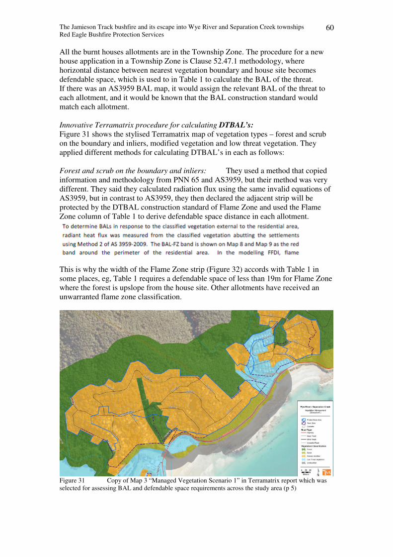
The Jamieson Track bushfire and its escape into Wye River and Separation Creek townships
Red Eagle Bushfire Protection Services 60
All the burnt houses allotments are in the Township Zone. The procedure for a new
house application in a Township Zone is Clause 52.47.1 methodology, where
horizontal distance between nearest vegetation boundary and house site becomes
defendable space, which is used to in Table 1 to calculate the BAL of the threat.
If there was an AS3959 BAL map, it would assign the relevant BAL of the threat to
each allotment, and it would be known that the BAL construction standard would
match each allotment.
Innovative Terramatrix procedure for calculating DTBAL’s:
Figure 31 shows the stylised Terramatrix map of vegetation types – forest and scrub
on the boundary and inliers, modified vegetation and low threat vegetation. They
applied different methods for calculating DTBAL’s in each as follows:
Forest and scrub on the boundary and inliers: They used a method that copied
information and methodology from PNN 65 and AS3959, but their method was very
different. They said they calculated radiation flux using the same invalid equations of
AS3959, but in contrast to AS3959, they then declared the adjacent strip will be
protected by the DTBAL construction standard of Flame Zone and used the Flame
Zone column of Table 1 to derive defendable space distance in each allotment.
This is why the width of the Flame Zone strip (Figure 32) accords with Table 1 in
some places, eg, Table 1 requires a defendable space of less than 19m for Flame Zone
where the forest is upslope from the house site. Other allotments have received an
unwarranted flame zone classification.
Figure 31 Copy of Map 3 “Managed Vegetation Scenario 1” in Terramatrix report which was
selected for assessing BAL and defendable space requirements across the study area (p 5)
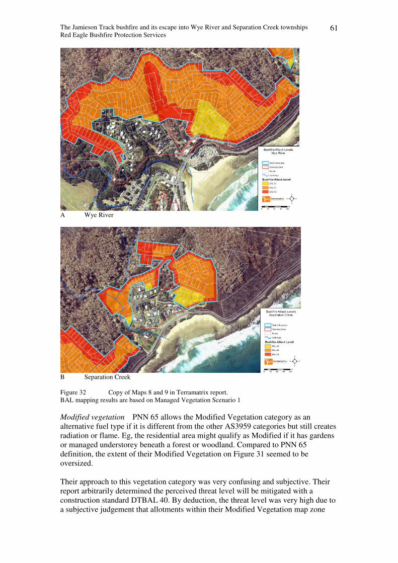
The Jamieson Track bushfire and its escape into Wye River and Separation Creek townships
Red Eagle Bushfire Protection Services 61
A Wye River
B Separation Creek
Figure 32 Copy of Maps 8 and 9 in Terramatrix report.
BAL mapping results are based on Managed Vegetation Scenario 1
Modified vegetation PNN 65 allows the Modified Vegetation category as an
alternative fuel type if it is different from the other AS3959 categories but still creates
radiation or flame. Eg, the residential area might qualify as Modified if it has gardens
or managed understorey beneath a forest or woodland. Compared to PNN 65
definition, the extent of their Modified Vegetation on Figure 31 seemed to be
oversized.
Their approach to this vegetation category was very confusing and subjective. Their
report arbitrarily determined the perceived threat level will be mitigated with a
construction standard DTBAL 40. By deduction, the threat level was very high due to
a subjective judgement that allotments within their Modified Vegetation map zone
The Jamieson Track bushfire and its escape into Wye River and Separation Creek townships
Red Eagle Bushfire Protection Services 62
cannot be relied upon to achieve defendable space status (specifically “where
defendable space for 50m or the property boundary, whichever is lesser, cannot be reasonably
assured” (p 6)). Their stated reasons (p6 and p47) included: “unlikely to be managed
as defendable space on a reliable ongoing basis”; “ongoing management of grass and
shrubs and clearing of leaf litter will be difficult for some residents”; owner “may be
absent for extended periods”; tree canopy removal may be precluded on steep slopes;
“elongated flames on steep slopes”; “exposure to convective heat from flames from
down slope”.
The student might presume that Terramatrix and government officials formed a view that
residents will not maintain their properties in the future because they had not done so in the
past. Is this a reasonable judgement or have they overlooked other factors such as (1) almost
all the burnt houses had been built without permit conditions to maintain their property, and
(2) that ongoing property maintenance is a permit condition for new houses, akin to a
contractual obligation. If reasonable, explain how a very high construction standard BAL will
mitigate the threat, particularly in the light of findings of the CSIRO report.
The student can consider why the government agencies continued to accept this subjective
version of threat assessment across the burnt area of the town when it was stripped of almost
all tree and understorey vegetation cover by the clean up crews. The student can consider
whether the policy was appropriate and fair or heavy handed and unjust.
Low threat vegetation Their report arbitrarily determined the perceived threat
level will be mitigated with a construction standard DTBAL 29. By deduction, the
threat level was very high due to a subjective judgement that allotments within this
zone will be difficult to maintain at a low fuel level.
The student can contrast their interpretation of Low Threat zone as a high level threat against
the AS3959 definition that it has a low threat status and most sub categories have no
requirement for fuel load to be managed.
In summary, the differentiation between BAL’s and DTBAL’s is justifiable because
of their very different calculation methods and procedures. Furthermore, because they
apply the bushfire attack level concept as the solution to a perceived or predetermined
threat level, their DTBAL map clearly refers to the construction standard BAL and
has no reference or correlation to a quantified BAL threat level derived by the
AS3959 process.
(5) Were the changes legally valid? The following questions are now relevant:
What legal framework or legal instrument allows government bodies to require a
resident of Wye River or Separation Creek to build a BAL 40 house when current
planning regulations calculate it at BAL 12.5? Which government body is liable for
compensation if no valid legal instrument exists?
The Jamieson Track bushfire and its escape into Wye River and Separation Creek townships
Red Eagle Bushfire Protection Services 63
Background - planning law hierarchy for bushfires The planning system in Victoria proceeds downward from the government objective
in a planning hierarchy under the Victorian Planning Provisions (VPP).
Hierarchy Level of VPP Location
Strategic policy issues that Council must consider Clauses 10 – 19
Zones that allow or prohibit land uses Clauses 30 – 39
Overlays that identify issues of concern that may cover one or more
Zones
Clauses 40 - 49
Particular provisions for implementing Overlays Clauses 50 – 59
Decision guidelines Clause 65
Referrals Clause 66
Clause 13.05 The Planning hierarchy for bushfires begins with Clause 13.05, which falls
within the Hazards category. The objective of Clause 13.05 is “to assist to strengthen
community resilience to bushfire”. Clause 13.05 is part of the group of Clause 13’s
environmental hazards. They set a best practice planning approach which aims to avoid or
minimise adverse impacts of hazards.
The student can note that bushfire objective is to improve resilience. By contrast, the
objective for erosion is much stronger - To protect areas prone to erosion.
Clause 44.06 Next planning level is Clause 44.06, the Bushfire Management Overlay
(BMO). It adds body to the Clause 13.05 objectives, and is implemented by Clause 52.47,
stating “An application to construct a building … must meet the requirements of Clause 52.47
unless a schedule to this overlay specifies different approved measures” As of 12 Aug 2016, there was no schedule to Clause 44.06 for Colac Otway Shire.
Clause 52.47 This clause details how to implement a permit application under Clause
44.06. Specifically, Clause 52.47-1 applies to an application to construct a single dwelling in
a Township Zone. It states – “an application under Clause 52.47-1 must meet all the approved
measures” unless “a schedule to Clause 44.06 may specify a different approved measure”, and
a 52.47.1 application must be accompanied by: bushfire hazard site assessment and bushfire
management statement “unless a schedule to Clause 44.06 specifies a different requirement”.
The decision guidelines include consideration of “whether all of the approved measures have
been incorporated into the application”. The BAL in this Clause is the AS3959BAL, not
DTBAL.
PNN 65 “This practice note provides advice on preparing and assessing an application
under Clause 44.06 Bushfire Management Overlay”. PNN 65 provides source information
about “Modified Vegetation” category and its application in Clause 52.47.3 Tables 1 and 2.
The BAL of PNN 65 is AS3959 BAL, not DTBAL.
Amendment C089 The April Terramatrix report stated: “The outcomes of the project will contribute to the
development of an integrated planning control (incorporated under Clause 52.03 Specific
Sites and Exclusions) for the fire affected area that will streamline the planning permit
process for people wishing to rebuild houses lost in the bushfire” (p2).
Since 31 March 2016, there has been a reference in Schedule to Clause 52.03 to an
“Incorporated Document” - “Land in Wye River – Separation Creek as identified in
The Jamieson Track bushfire and its escape into Wye River and Separation Creek townships
Red Eagle Bushfire Protection Services 64
Schedule 1 in the incorporated document - Wye River and Separation Creek bushfire
affected properties (March, 2016)”, which was Amendment C089.
The explanatory report that accompanied Amendment C089 seems to understate its
impact by listing only three affected Clauses that appear to be at the lower end of the
planning hierarchy: “This amendment affects clauses and schedules: Clause 52.03
Schedule, Clause 61.01 Schedule, Clause 81.01 Schedule”. But the C089 document
itself adds several others to the list of affected clauses: 32.05-1, 32.05-5, 32.05-8,
35.06-1, 35.06-5, 42.03, 43.05, 44.01, 44.06, 42.03, 44.01 and 52.17. It does not
mention Clause 52.47, which fully interdependent with 44.06.
Part 4.1 of the “Incorporated Document” stated “Any requirement in Clause … 44.06
of the planning scheme to obtain a permit to construct a building or construct or carry
out works does not apply to buildings and works associated with one dwelling on a
lot”. It is the only reference to 44.06. This suggests Clause 44.06 Overlay application
requirements and the influence of PNN 65 were extinguished for the burnt properties.
Because procedures and requirements of both depend on AS3959, its relevance seems
to be also extinguished. These and other aspects may present a few legal problems:
Level of authority Can a lowly Clause 52.03 order lawfully suspend the superior Clause 44.06 Planning
Overlay in these townships in contravention to Clause 44.06 specifications?
The application requirements of the higher order Clause 44.06 and its interdependent
subordinate Clause 52.47 are very specific and can only be overruled by a Schedule to
Clause 44.06, yet the Amendment does not include a Schedule.
Can a lowly Clause 52.03 order lawfully overrule the very specific measures in the
superior Clause 44.06 Planning Overlay that by definition reduce risk to life and
property to an acceptable level?
Clause 44.06 has a defined method of reducing such risk from a deemed hazard – it
deploys Clause 52.47.1 for Township Zones and upon completion of the 52.47.1
process, the risk is deemed to be acceptable.
By contrast, Clause 52.03 introduces a different process with no clear reference to
purpose or deemed hazard. No support paper was referenced in the Amendment C089
Confusion
Clause 44.06 may remain co-active alongside Amendment C089.
If permit application requirements of Clause 44.06 can only be extinguished by a
Schedule, it may technically remain active.
Clause 52.47 remains co-active alongside Amendment C089
Amendment C089 extinguished application requirements of Clause 44.06 without
reference to its interdependent subordinate Clause 52.47. Amendment C089 did not
mention Cause 52.47, which suggests it was not extinguished.
Conflict with purpose of Overlay Para 4.6 of the “Incorporated Document” which is Amendment C089, requires the
responsible authority to consider the decision guidelines of Clause 65, which includes
“The purpose of the zone, overlay or other provision”. But Amendment C089
extinguished the application requirements of the Overlay that were specifically
The Jamieson Track bushfire and its escape into Wye River and Separation Creek townships
Red Eagle Bushfire Protection Services 65
designed to achieve the purpose of the Overlay. Therefore, technically C089
extinguishes the method of achieving the purpose of the BMO.
Explanation: Clause 44.06 has two specific purposes which it achieves via 52.47.1
for Township Zones, “unless a schedule to 44.06 specifies otherwise”.
– “To ensure development is only permitted where the risk to life and property from bushfire can be
reduced to an acceptable level.” . To identify areas where the bushfire hazard warrants bushfire protection measures to be implemented.
In regard to the former, C089 includes no mention or consideration of reducing
bushfire risk to acceptable level. In regard to the latter, C089 assumes all allotments
have a high risk and imposes very high DTBAL levels onto each allotment.
The student can consider whether Amendment C089 requirements for very high DTBAL
levels on each allotment and defendable space to the property boundary can be presumed to
achieve both purposes of the BMO, or should C089 have included a deeming mechanism, or
indeed, have the BMO purposes been extinguished by C089 de facto?
Extinguishment of Clause 44.06 permit requirements means extinguishment of
PNN 65 requirements, which together mean extinguishment of AS3959 relevance
from burnt area PNN 65 exists solely to describe the application process for Clause 44.06, the use of
Clause 52.47 and reliance on AS3959. By extinguishing application requirements of
Clause 44.06 from the map of burnt area, Amendment C089 extinguished each from
the burnt area and replaced it with a new model with different processes and
requirements. The new model uses the above documents as a reference source.
Extinguishment of Clause 44.06 permit requirements means extinguishment of
PNN 65 requirements, which means extinguishment of “Modified Vegetation”
Zone requirements from burnt area PNN 65 is the source document for Modified Vegetation category, and its specific
usage in Clause 52.47. The Terramatrix DTBAL map in Amendment C089 used
Modified Vegetation as a vegetation category, but applied a very high threat level to it
in contrast with the description in PNN 65.
The BAL of Regulation 811 is legally different from the DTBAL of Amendment
C089 The second purpose of the Amendment C089 was “To specify bushfire attack levels
for the purpose of regulation 811(1) of the Building Regulations 2006”.
Regulation 811 (4) states that “bushfire attack level has the same meaning as in the
Australian Standard AS 3959”. Technically, the same meaning assumes usage of the
same calculation method and process to determine the bushfire attack level, ie, the
AS3959 method or its slight modification in PNN 65. As shown above, Amendment
C089 included a map of DTBAL’s that was derived from the Terramatrix report,
which used a very different process and calculation method from AS3959 / PNN 65.
Thus, Amendment C089 prescribes construction zone DBTAL’s to multiple
allotments based on a perceived or predetermined threat level in the vegetation
category. This is not related to the BAL of threat that is calculated by AS3959 and
mitigated by the corresponding construction standard BAL that the Building
Regulations require. In addition, because C089 effectively excludes the AS3959
requirements from the burnt area, it excludes application of the Building Regs. This
The Jamieson Track bushfire and its escape into Wye River and Separation Creek townships
Red Eagle Bushfire Protection Services 66
seems to mean that building inspectors cannot legally enforce a C089 DBBAL within
the burnt area.
What is legal weight of Amendment C089? In this case, the Amendment is the Incorporated Document.
PPN 13 clarifies that “If a document is incorporated into a planning scheme, its
content or strategic basis is less likely to be capable of challenge when using it to
make a planning decision. The decision-maker or VCAT is entitled to presume that
the strategic basis for the document was considered at the time of its incorporation
into the planning scheme and to give it due weight”
It suggests that at least two factors may reduce its weight:
• the amount of public scrutiny the document has been subject to
• the document’s currency and whether or not its relevance has been superseded
by more recent studies or events.
To change it: “An incorporated document can only be changed by an amendment to
the planning scheme. The revised text of the document must be placed on exhibition
in addition to any proposed changes to the scheme ordinance”.
The student can assess whether the Amendment is still relevant to the Planning
Scheme in the light of zero public scrutiny prior to incorporation, dismay in the local
community, confusion in legal aspects mentioned above and the almost complete
removal of trees and ground vegetation in burnt areas by the clean up crews since
March 2016.
Summary
Government has accepted the use of the AS3959 model and its BAL as a proxy for
bushfire risk in Wye River / Separation Creek despite flame radiation being a
negligible cause of house loss in severe bushfire, the AS3959 model being a single
threat model, and the assumptions of AS3959 being unrelated to bushfire reality.
Government has adopted a very substantial variation from the BMO and AS3959
rules for Wye River / Separation Creek via Amendment C089 that has assigned very
high DTBAL’s for house rebuilding If the original BMO rules were in operation,
BAL’s would be substantially lower in almost all areas of the towns. The Amendment
was based on a report which calculated DTBAL’s using subjectively derived
perceived or predetermined threat levels. The C089 Amendment is shown to present
several legal challenges, particularly its apparent inability to operate in the Building
Regulations.
The Jamieson Track bushfire and its escape into Wye River and Separation Creek townships
Red Eagle Bushfire Protection Services 67
Chapter 9 Summary of the sad saga so far …
How not to stop a bushfire, how not to protect a town
Government-directed-bushfire-suppression fails on Day 1
Government-directed-bushfire-suppression fails on Days 2 – 4
Government concocts carefully considered suppression strategy changes on Day 4 and it
backfires on Day 7.
The government-directed-bushfire-suppression escapes the control line. Government
withdraws troops at fire ground. Some reallocated to assist evacuations from towns in its path,
no reference found yet to suggest a role in town defence.
The Government-directed-bushfire-suppression escapes and runs 4 km through government
land, exiting through a non existent barrier into private property and smashes towns that were
declared by government years ago as extreme bushfire risk
A government issues sudden warning at Christmas lunch time and evacuates residents from
the towns. Government praises the obedient evacuators. Government later evacuates Lorne
residents when not endangered. Was this a trial run? Government condemns the disobedient.
Towns have impressive glossy government protection plans to protect them from external
fires but government has not yet put protection infrastructure on the ground.
Government laws exist for clearing hazards from private property within the towns, but they
have not been enacted.
The out of control ex-government bushfire throws embers into vacated towns that ignite as
spot fires
Government provides one strike team which saved houses and aerial bombers which wet
several spot fires for the first hour of the bushfire attack on the towns but then seemed to
declare it as too dangerous for ground based fire fighters to extinguish spot fires and houses.
Government and fire fighters allow spot fires with half metre tall flames to spread unchecked
for over 12 hours, by which time 116 houses are destroyed.
Premier and Fire Commissioner reassure the people, saying a local fire was overdue, so this
one was to be expected and that it could have been worse - 200 houses could have been lost.
The government appointed watchdog investigated the above events and declared the
government’s policies and procedures were applied, including procedures for warning
residents. Politicians use this report to reassure the public.
CSIRO report finds that houses built at highest fire resistance were destroyed when the
average flame height was less than 0.4m tall.
Government spends millions on rehab, and takes control of house rebuilding program,
declaring that houses must be rebuilt at the highest possible fire resistance levels (= most
expensive) because it believes residents will not maintain their properties at low fuel load.
Is this really the hand of government policy in action in 2015 / 2016, taking charge, all
powerful, free from blame ... Now penalising the burnt out residents, as untrustworthy?

The Jamieson Track bushfire and its escape into Wye River and Separation Creek townships
Red Eagle Bushfire Protection Services 68
References
AS3959 Construction of buildings in bushfire prone areas AS3959-2009 plus
Amendments Standards Australia
Blanchi R, Leonard J and Leicester RH (2006) Bushfire risk at the rural-urban
interface. Australasian Bushfire Conference, 6-9 June, Brisbane, Queensland
Blanchi R and Leonard J (2008) The influence of human behaviour on house loss
Bushfire CRC conference, Adelaide [POSTER]
Bushfire Solution Paper 6A House loss rate in a severe bushfire Part 1 Ash
Wednesday bushfire fire attack category - The influence of house occupation rate
http://www.redeagle.com.au/wp-content/uploads/2014/07/Paper-6A-House-loss-rate-
in-severe-bushfires-Part-1.pdf
Bushfire Solution Paper 6B House loss rate in a severe bushfire Part 2 Duffy
bushfire attack category - The influence of distance from ember source
http://www.redeagle.com.au/wp-content/uploads/2014/07/Paper-6B-House-loss-rate-
in-severe-bushfires-Part-2.pdf
Buxton M, Haynes R, Lechner, Butt A (2009) RMIT Submission to the Black
Saturday Bushfires Royal Commission, School of Global Studies, Social Science and
Planning, RMIT Melbourne Australia
Colac-Otway Fire Management Plan, Version 8 (2012) Shire of Colac Otway,
Victoria, Australia
CSIRO Report (2016) Wye River / Separation Creek Post-bushfire building
survey findings by Leonard J, Opie K, Blanchi R, Newnham G, and Holland M
Report EP16924 Report to the Victorian Country Fire Authority
DELWP (2015) Measuring Bushfire Risk in Victoria Department of
Environment, Land, Water and Planning, Victoria, Australia
DELWP (2015) Barwon Otway Strategic Bushfire Plan Department of
Environment, Land, Water and Planning, Victoria, Australia
Government authorities’ Fact Sheet Bushfire Attack Levels 31 March 2016
Shire of Colac Otway and State Government of Victoria, Australia
IGEM Report (2016) Review of the initial response to the 2015 Wye River –
Jamieson Track fire Inspector-General for Emergency Management, Government of
Victoria
Leonard J, Blanchi R, and many (2009) Building and land-use planning research
after the 7th
February 2009 Victorian bushfires Preliminary findings Evidence
to VBRC (2010), Witness statement CRC.300.007.0135 to 300.007.0314

The Jamieson Track bushfire and its escape into Wye River and Separation Creek townships
Red Eagle Bushfire Protection Services 69
Manual of Bushfire Behaviour Mechanisms in Australian Vegetation: Flame Spread
and Flame Height Version 1, May 2016
http://www.redeagle.com.au/wp-content/uploads/2016/06/1-MANUAL-of-Bushfire-
Behaviour-Mechanisms-in-Australian-Vegetation.pdf
McArthur AG (1967) Fire behaviour in eucalypt forests Leaflet 107, For.
Res. Inst., For. and Timber Bureau, Canberra
McGrattan KB, Baum HR, Hamins A (2000) Thermal Radiation from Large Pool
Fires Nat Inst Standards and Tech, US Dept Commerce NISTIR 6546
Miller S I. Carter W, Stephens RG (1984) Report of the bushfire review committee
on bushfire disaster preparedness and response in Victoria, Australia, following the
Ash Wednesday fires of 16 February, 1983 Government of Victoria, Australia
PPN 13 Planning Practice Note 13 (2015) Incorporated and Reference
Documents Department of Environment, Land, Water and Planning Victoria,
Australia
PPN 65 Planning Practice Note 65 (2014) Preparing and Assessing a
Planning Application Under the Bushfire Provisions in Planning Schemes
Department of Transport, Planning and Local Infrastructure, Victoria, Australia
Project Vesta (2007) Fire in Dry Eucalypt Forest: Fuel structure, fuel dynamics and
fire behaviour. Ensis-CSIRO and Department of CALM, WA
Sit Reps Situation Reports (2016) Copies of daily Situation Reports for
Jamieson Track bushfire from Colac Incident Control Centre Published in The
Age on line 13 January 2016, 8.36pm
Terramatrix (2016) BAL assessment study Wye River & Separation Creek
BAL Mapping Report prepared by Terramatrix for DELWP
Thomas PH (1962) The size of flames from natural fires Department of
Scientific and Industrial Research and Fire Offices' Committee Joint Fire Research
Organisation, Fire Research Note 497, May 1962.
Thomas PH (1970) The rates of spread of head fires in gorse and heather
Ministry of Technology and Fire Offices' Committee Joint Fire Research
Organization, Fire Research Note 796, January 1970
VBRC (2010) Victorian Bushfire Royal Commission Final Report, Government of
Victoria
Whittaker J, Haynes K, , Handmer J, McLennan J (2013) Community safety during
the 2009 Australian ‘Black Saturday’ bushfires: an analysis of household
preparedness and response Int Journal of Wildland Fire 22, 841–849
Wilson AAG and Ferguson IS (1984) Fight or flee? – A case study of the Mt
Macedon bushfire Aust Forestry 47, 230 - 236