colorado aerotropolis visioning study attachment a ... · pdf filecolorado aerotropolis...
TRANSCRIPT

Colorado Aerotropolis Visioning Study Attachment A: Outreach
Attachment A-4: Other Agency Coordination Meetings


Other Agency Coordination Meetings
Agency Date Meeting Materials
• Front Range Airport Advisory Board February 26, 2016 • DRCOG TAC April 25, 2016 • E-470 PHA April 28, 2016 • Metro Denver Economic June 8, 2016
Development Corp Aviation Coalition
• Presentation
Urban Drainage and Flood Control District
February 4, 2016 • Meeting Notes
Aurora Water October 15, 2015 • Meeting Notes
E-470 PHA October 14, 2015 • Meeting Notes
DRCOG September 28, 2015 • Meeting Notes
Metro Wastewater Reclamation District
September 18, 2015 • Meeting Notes
Denver Water September 4, 2015 • Meeting Notes
South Adams County Water and Sanitation District
August 27, 2015 • Meeting Notes
Colorado Office of Economic Development and International Trade
June 1, 2015 • Meeting Agenda
• Meeting Notes
Front Range Airport May 5, 2015 • Meeting Notes
CDOT Aeronautics May 1, 2015 • Meeting Agenda
• Meeting Notes
E-470 PHA April 30, 2015 • Meeting Agenda • Meeting Notes
DRCOG April 30, 2015 • Meeting Agenda • Meeting Notes
RTD April 29, 2015 • Meeting Notes
Peña Boulevard Study April 22,2015
• Meeting Agenda
• Meeting Notes

Agency Date Meeting Materials
Coordination
I-70 East EIS Coordination April 20, 2015 • Meeting Notes
Metro Denver Economic Development Corp
April 17, 2015 • Meeting Agenda

Final Meeting Notes Project: Colorado Aerotropolis Visioning Study
Subject: Coordination Meeting—Urban Drainage and Flood Control District (UDFCD) NE Quadrant
Date: February 16, 2016
Location: UDFCD
Attendees: David Mallory (UDFCD); Teresa Patterson (UDFCD); Tom Reed (DIA); representatives from Denver, Commerce City, and Fulenwider Development Properties; Chris Primus (HDR), Jay Hendrickson (CDOT)
Distribution: File
Summary of Discussion
1. Jay Hendrickson and Chris Primus attended this meeting of the NE Quadrant Group of the UDFCD as guests to present and introduce the Aerotropolis study to the group. This group meets once a month to coordinate on drainage and flood control issues. There is no set agenda; the group typically operates a roundtable to coordinate a variety of issues.
2. Chris and Jay provided an overview of the aerotropolis visioning study, its major tasks and objectives, as well as the current status of the study.
3. Chris and Jay had an informal meeting with Shay Thomas a couple of weeks ago which led to an invitation to this meeting. Shay provided Chris and Jay a description of the UDFCD and its vision and goals for the area. Chris used this information to prepare a brief summary for inclusion in the Aerotropolis final report. Chris will send the draft summary to Teresa Patterson for her review.
4. Chris and Jay notified the group of the next Study Review Committee meeting on March 1. UDFCD will be attending this meeting to give a brief presentation about the District and its mission, goals, and plans for the area. Chris will send Teresa an Outlook invitation to the March 1 meeting.
5. Many times coordination of regional detention facilities is challenging. It is one thing to identify them in a master plan, but sometimes difficult to implement as development occurs. This is because the land may not already be in the jurisdictions ownership, or the land is not available, or the land is valuable for other purposes, and many other reasons.
6. David Mallory noted that there is a restoration project under way at Frist Creek near Tower and Pena, in the 56th Avenue area under the FasTracks line. He also noted that the Rocky Mountain Arsenal has recently updated its Conversation Plan Master Plan. This plans for future expansion of its facilities to expand the growing visitor trends at the arsenal. For example, a trail in the First Creek floodplain will eventually be connected onto a trail on the Refuge property.
7. David also strongly encouraged that initial review for Section 404 permitting purposes be done at this visioning stage of the Aerotropolis study. An aerotropolis development could potentially not be allowed to occur because of Section 404 issues. This is another reason to make sure preservation of floodplains is part of the overall development plan in the Aerotropolis area. He suggested the Aerotropolis team get an ecologist with Section 404 expertise on board to review the general plan and provide some input. In support of this, he noted that the first word of the visioning statement is “sustainable.”
8. David mentioned that the District is first and foremost focused on protecting people and property from natural hazards, particularly floods. Floodplain preservation is a key recommendation that the District encourages.
1 of 2

Final Meeting Notes: Colorado Aerotropolis Visioning Study Coordination Meeting— Urban Drainage and Flood Control District (UDFCD) February 4, 2016 9. There are several drainages that traverse the Aerotropolis study area, including Irondale Gulch, First
Creek, Second Creek, Third Creek, as well as Box Elder Creek on the far east of DIA. It was noted that Sand Creek also traverses the lower southwest corner of the study area.
10. In general, each drainageway has a master plan. These master plans are in various stages of completion with different levels of detail for each of the drainageways.
11. There are also typically IGAs in place for each of these drainages. There is an IGA for First Creek and for Second Creek. There is an IGA drafted for Third Creek but has not been completed yet. There are two IGAs in place for Irondale Gulch—one among Aurora, Denver, and UDFCD; the second IGA is among Denver, UDFCD, and the Rocky Mountain Arsenal.
12. These IGAs generally stipulate cost-sharing for facility implementation. In general, the master plans are formed and the IGAs implement the agreements of the master plans.
13. Many of the drainages traverse multiple miles well beyond upstream of the Aerotropolis study area. Many of them have two separate master plans. Some of them are divided by upstream of the Arsenal and downstream of the Arsenal, or upstream of DIA and downstream of DIA.
14. DIA has been updating its drainage plan through RESPEC, the consulting firm who is completing the update for DIA. It was noted that closer to the South Platte, adhering to the master plans is more important. There is typically a general lack of demands for water closer to the South Platte. The infrastructure needs to accommodate flood waters per the master plan are identified but certainly not all of that infrastructure is in place. This infrastructure is more important closer to the South Platte River than farther upstream in its drainageway.
15. UDFCD does not have a permitting process to make sure that development is in compliance with the master plans. UDFCD technically serves as an extension of the local governments regarding these issues. Each respective local government is responsible for implementing its portion of the plan. In general, implementation of the plan occurs in tandem with development. However, UDFCD has a program to assist the communities with maintenance of the facilities after they have been implemented.
16. Regional trails are often a part of the drainageway plan within the floodplains. One master plan of a regional scale is called the Emerald Strands Trail Plan. It was developed many years ago as a joint effort of several jurisdictions. It identified trails of Second Creek, First Creek, the Highline Canal, and multiple other areas.
17. In general, the jurisdictions are quite cooperative in developing trail systems, and proof of that is in the regional trail system along the Platte River and other drainages throughout the metropolitan area.
2 of 2

Meeting Agenda
Project: Colorado Aerotropolis Visioning Study
Subject: Coordination Meeting
Date: October 15, 2015
Location: Aurora Water Offices
1. Introductions
2. Study Overview and Schedule
3. Study Methodology and Outcome
4. Coordination Opportunities
5. Other
6. Action Items
1

FINAL Meeting Notes Project: Colorado Aerotropolis Visioning Study
Subject: Coordination Meeting—Aurora Water
Date: October 15, 2015
Location: City of Aurora
Attendees: Aurora Water: Sarah Young
HDR: Kevin Bergschneider, Rick Pilgrim and Chris Primus
Distribution: File
Summary of Discussion
1. Introductions were made. Chris Primus gave a brief overview of the Aerotropolis Study.
2. Sarah Young handles long-range planning for Aurora Water. They have recently been working on their long-range plan, as well as wastewater master plan.
3. Action item: Send Sarah a draft of the write-up of utility opportunities and constraints.
4. Sara mentioned that the integrated water master plan has used an in-house land use allocation model called LUAM. This produced forecasts of population and employment through the year 2070 in 5-year increments. Sara will provide this as a reference for the Aerotropolis Study.
5. Sarah asked if we would be looking at detailed utilities plans. The Aerotropolis Study is at a higher level than detailed plans. Instead we are trying to understand the landscape of challenges and opportunities concerning the major utilities of water, wastewater, power, and drainage.
6. Concerning wastewater, Sarah mentioned that serving the northern part of the city has been a challenge as it has grown rapidly. Developments are happening now and she needs to plan and build utilities accordingly since they are needed now. This will involve building lift stations.
7. In contrast, the wastewater could be gravity fed to Second Creek interceptor to the Northern Treatment Plant. However, that line will not be available for another 10 years. The needs for wastewater infrastructure are occurring now. Aurora cannot wait and must build the lift stations, and the life cycle of these lift stations will not be realized for sometime. At one point eventually, Aurora could consider sending wastewater to the Northern Treatment Plant through the Second Creek interceptor.
8. Regarding water, it was mentioned that Denver Water currently has end-of-line issues to serve DIA, and some water is wasted at the end of the line to clear it for water quality issues. Sarah agreed that area is a natural area where regional collaboration would be sensible. But there are very many complexities involved regarding that potential collaboration. These complexities include detailed water quality issues among the two water districts.
9. Sarah mentioned that the City and County of Denver and Aurora Water together have joint project for 56th Avenue Interceptor. This agreement will need to be renegotiated in 2018. Because it is a temporary contract with Denver Water, it is not something she can count on consistently and cannot put that water definitively into her long-range plans, because of the need for continual renegotiations as contract periods expire. For this reason, agreements amongst water districts make the logistics difficult, even though there may be long-term cost savings.
10. Aurora Water does not have water quality issues at the end of the line. Water redundancy is provided among the smaller pipes serving the areas.
1 of 2

FINAL Meeting Notes: Colorado Aerotropolis Visioning Study Coordination Meeting—Aurora Water Water October 15, 2015 11. Aurora’s needs for water and wastewater are a difficult challenge. It will be achievable to serve Aurora
and its needs through the year 2070 within its current boundaries. However there is discussion of a potential eastern annexation north of Quincy in the old Lowry Range. A potential eastern annexation would go beyond Aurora’s current capabilities to serve that area with water and wastewater.
12. Sarah asked about if the Aerotropolis Study is interested in stormwater needs. Aurora has intergovernmental agreements with DIA that stipulate that if a flow exceeds a certain cubic feet per second, that there would be the requirement to build stormwater ponds. This is relative to specific points on tributaries, and they are used for stormwater drainage.
13. The Urban Flood Control Drainage District is currently updating its long-range plan for Third Creek. Matrix is the consultant performing this work.
2 of 2


Meeting Agenda
Project: Colorado Aerotropolis Visioning Study
Subject: Coordination Meeting
Date: October 14, 2015
Location: E-470 Offices
1. Introductions
2. Study Overview and Schedule
3. Study Methodology and Outcome
4. Improvement Plans
5. Coordination Opportunities
6. Other
7. Action Items
1

1 of 2
FINAL Meeting Notes Project: Colorado Aerotropolis Visioning Study
Subject: Coordination Meeting—E-470 Public Highway Authority
Date: October 14, 2015
Location: E-470 Public Highway Authority
Attendees: E-470 Public Highway Authority: Chrissy Palestine, Jason Myers, John McCuskey, Neil Thomson, and Stan Koniz
HDR: Rick Pilgrim and Chris Primus
Distribution: File
Summary of Discussion
1. John McCuskey asked why CDOT is running this study. Chris Primus gave a brief overview of the history of the study, the intentions, and planned outcomes of the study.
2. It was asked if a regional authority indeed might be formed after the study concludes. It was suggested that some sort of authority probably would be formed.
3. There is an investment grade traffic and revenue study available on E-470’s Web site. FHU looked at level of service and EPS did the economic analysis. This was conducted in spring of 2014. The Aerotropolis Study may want that as a reference.
4. There is also an interchange expansion plan available on E-470’s Web site under the Finance Relations page. CDM-Smith conducted the study. The following interchange expansions were identified (listed according to priorities):
a. Quebec, which has recently been constructed and is now open.
b. Sable, which is now Potomac, in 2025
c. 112th in 2035
d. 88th in 2035
e. 48th in 2035
Also identified in that study was completing and improving the interchanges with I-76 and I-70 with E-470. However, it is a later time frame for these interchanges.
5. The E-470 Authority also has an accelerated interchange policy. This is for developers who want an interchange built in the near term. They recently finished two under this policy—Gartrell and Jamaica on the southern side of E-470. This policy entails that the developer pays up front under an agreement of record with the jurisdictions, then E-470 Authority builds the interchange. And as time goes on, E-470 Authority pays back the developer over a period of several years for the cost of the interchange.
6. The E-470 Authority will be developing some of the toll plazas that have been discontinued. One of these is north of I-70 and another one is north of Peña. This would have convenience stores and gas stations and other sorts of commercial development serving motorists.
7. E-470 will be six lanes down south in the next couple of years. After that, Quincy at I-70 will be widened eventually. In the long term, all of E-470 will be widened to at least six lanes.
8. Chris Primus distributed a map of the conceptual ring road around the DIA property. He pointed out the conception of it, the need for it based on experience of other Aerotropolises around the world, as well as the fact that as conceived now, it uses the E-470 alignment.

FINAL Meeting Notes: Colorado Aerotropolis Visioning Study Coordination Meeting—E-470 Public Highway Authority October 14, 2015
2 of 2
9. There was discussion about the ring road concept. In the end the E-470 Authority board would decide if that would be the best use of its right-of-way. In general, the board has been are open to selling their right-of-way. They have done so for a variety of water and gas lines. Because in the end, E-470 Authority is a business recouping its cost to pay back the bonds.
10. In general, the concept of a ring road was supported among the E-470 Authority staff that it makes to reserve right-of-way.
11. E-470 Authority’s plans include a freeway needing 300 feet of right-of-way, plus 75-foot easements on each side, for a total of 450 feet.
12. E-470 Authority suggested we use their official logo for depicting E-470 symbol on our maps.


1 of 2
FINAL Meeting Notes Project: Colorado Aerotropolis Visioning Study
Subject: Coordination Meeting—DRCOG
Date: September 28, 2015
Location: DRCOG
Attendees: Daniel Jerrett (DRCOG), Adam Christian (DRCOG), Arleen Taniwaki (Arland), Keith Borsheim, (HDR) Chris Primus (HDR)
Distribution: File
Summary of Discussion
1. DRCOG is currently updating the 2040 data set to produce cycle 2 of 2015 for their 2040 forecast. They are close to finishing this within the next couple of months. It has additional information from local governments. However, Aurora has not provided its information yet, so DRCOG will incorporate Aurora’s information in the 2016 round of updating the 2040 data set.
2. Daniel Jerrett provided a brief overview of Urban SIM’s land use allocation model. DRCOG works with the state demographer to establish the regional control total. The state demographer updates this about once a year. It is a back and forth procedure to determine the number for the DRCOG area. DRCOG further divides this control totals to the county level, which is then one of the input to the land use Urban SIM model. The model employs a location choice model that uses econometric regressions.
3. Previously, DRCOG used a utility-driven model. Zones were ranked based on attractiveness/proximity to existing urban centers. Employment control total was then distributed among the zones. Smooth curve and predictable. UrbanSIM now employed – dataset has 3 components: 1) parcels (GIS); 2) building data set and attributes (zoning, square footage); 3) inventory of number of employees by establishment, shows physical location of job clusters. Using these inputs, the UrbanSIM synthesizer swells sample population data up to regional control total; then distributes residential population by income level consistent with Census tract data. There is typically not enough planned or available housing to place all of the additional residents. For the excess household demand, UrbanSIM will scan for parcels with available development capacity, then prioritize where development occurs based on location choice model (income and housing affordability are primary drivers, not access to transit, amenities). Model is dynamic such that UrbanSIM will allocate growth to outlying, less expensive areas once the price of land increases in highly desirable areas in response to household demand. DRCOG relies heavily on input and feedback from local jurisdictions with respect to current and future plans.
4. The DRCOG area is forecast to become a less employment-rich region, with the number of jobs per person decreasing to 0.54 by 2040, compared to 0.59 currently in 2015. What accounts for this shift (aging population, more children per household)? Any insights into how this shift may translate into different development patterns (ie. more multifamily or multigenerational housing)? Primarily aging population – 1 in 4 residents will be over age 60 in 2040. Model does not assume dramatic expansion of urbanized area. New housing is located around employment centers. Average trip distances have decreased as a result. Some fixed inputs to the inputs are based on master plans—for example, a 13,000-unit development is proposed elsewhere within the region. Many local TOD plans around station areas anticipate 1,000s of new housing units.
5. Can DRCOG provide a breakdown of the 2040 employment forecasts by industry sector? If unavailable, is any additional information available on the assumptions/methodology DRCOG uses to build up to its regional totals? Industry sectors remain constant for 2040 employment projections—forecasting by industry sector is in the works. REMI is being pilot-tested. Population forecasts come from Region 3—

FINAL Meeting Notes: Colorado Aerotropolis Visioning Study Coordination Meeting—DRCOG September 28, 2015
2 of 2
DRCOG. Likely aging population drives growth in health care, but this is just a hypothesis. Urban SIM uses 22 codes rolled into 6 sectors. DRCOG is able to share these codes with HDR.
6. In a study of off-airport jobs surrounding LAX, the majority of jobs were in the accommodations/food services (23.4%), transportation/warehousing (18.9%), manufacturing (7.1%), and wholesale trade (6.7%), and administrative/waste management (6.1%) sectors. Do you foresee a similar mix surrounding DIA? Are there other industry clusters that you think DIA is uniquely poised to attract? Denver and DFW. Lots of shipping/freighting. Will be difficult to attract talented labor to DIA. Contrary to the guiding assumption of the Aerotropolis scenario, Prologis moved from DIA to downtown Denver where amenities are concentrated and millennials want to locate.
7. Chris inquired about the potential of an Aerotropolis scenario attracting more employment that leads to one of two options—either a reallocation from other areas of the region or exceeding the regional control total of 2040. Daniel reminded that population would need to be increased as well in this scenario. He said that the migration of people to the area would need to be examined, because this would affect the potential for employment to exceed the current regional control total.
8. Daniel said that DRCOG cannot exceed the regional control total for their planning purposes, but a study like this has much more flexibility. He said that DRCOG would not be able to endorse or in any way convey that it was a DRCOG planning assumptions to exceed their regional control total. He understood that for academic purposes, a study like this could exceed that number without a problem.
9. Arleen mentioned Commerce City requested a meeting with the study team to discuss the DRCOG projection. This has been scheduled for Wednesday, 10/7. Arleen suggested it might make sense for Daniel to attend this meeting. Daniel will check his schedule and will try to accommodate this meeting. Arleen will notify Commerce City that Daniel has been invited.
10. Chris asked about the possibility of having DRCOG use the Urban SIMs model to produce a land use data set for Aerotropolis. Daniel said that currently the area out there is not attractive to employment in the Urban SIMs modeling parameters. The zones out there could be made to be very attractive. To manually force employment to reallocate there as opposed to other areas in the region. This might take trial and error and this would include adjusting the zoning and other inputs. The zoning is a very important parameter to allow developments to take place that the model uses. He mentioned that many times areas like these are not zoned properly, and the model therefore doesn’t allocate growth. Oftentimes, municipalities address the zoning pending development occurring, instead of setting up a long-range plan.
11. Adam asked again about the locational aspect of the Urban SIMs model. He asked if there is a visual that would demonstrate the locational desirability throughout the study area compared to the rest of the region. Daniel mentioned that DRCOG has a beta of a Web application that is under development. They might be able to share the app with the study team at this stage. This app will allow the community to look at the desirability of zones across the region.
12. Chris discussed the importance of the Economic Development Corporations (EDC). EDC representatives from the jurisdictions typically attend study team meetings. Meetings have also been held with Tom Clark with Metro Denver EDC. Chris mentioned that it’s possible that a panel of EDC representatives will be convened, or a special meeting with EDC representatives will be held. If this happens, Daniel will be invited to this meeting.


FINAL Meeting Notes
Project: Colorado Aerotropolis Visioning Study
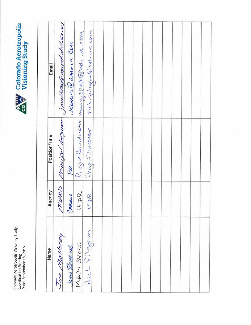
Subject: One-on-One Agency Coordination Meeting—Metro Wastewater Reclamation District
Date: 10:30 Friday, September 18, 2015
Location: Metro Wastewater Reclmation District 6450 York Street, Denver 80229
Attendees: Jim Mallorey (MWRD); John Rehring (Carollo Engineers); Rick Pilgrim (HDR); Mary Speck (HDR)
1. Introductions were made.
2. Rick Pilgrim described the background of the study and CDOT’s role to lead the study as a neutral party. He said the purpose of today’s meeting was to listen to the perspectives and visions of the Metro Wastewater Reclamation District (MWRD) regarding the study. He further mentioned that due to terms of the grant, the study needs to be concluded by end of the calendar year.
3. Rick explained that the study will develop a framework for development of an Aerotropolis, based on cooperation between jurisdictions engaged in the study—Adams County, City of Aurora, City of Brighton, City and County of Denver, Commerce City, and DIA. An amendment to the IGA about DIA will allow 1,500 acres to be developed on airport property, and the participating jurisdictions will share the revenue generated by development. The framework will address both transportation and utility infrastructure.
4. Jim Mallorey explained that the members of the MWRD are Denver, Aurora, Brighton, and South Adams County Water and Sanitation District (not Adams County). Essentially, the entire metropolitan area is served by MWRD, with the exception of the Littleton/Englewood plant.
5. Unincorporated areas are also served by MWRD, either under the members or as “special connectors.” A member is a municipal jurisdiction and is a Board member; special connectors represent a defined geographical area and they are not Board members.
6. Carollo is conducting a study for MWRD that taking a regional approach to wastewater management. The study will determine what flows north of I-70 and east of the South Platte would best be contributors to the new Northern Treatment Plant. They are considering a new interceptor along Second Creek that would connect to the South Platte Interceptor. The study will compare the long-term costs of MWRD treating the flows with the costs of constructing the new interceptor. The first step is to determine the approach; apportioning of costs and how this would be funded will be a later step.
7. John Rehring suggested that MWRD consider adding an evaluation criterion to their list about the scenario’s ability to contribute to regional infrastructure related to a future Aerotropolis development.
8. Rick explained that the study team had used growth projections from DRCOG and comprehensive plans from jurisdictions to develop employment and population projections based on an Aerotropolis scenario. He indicated that the latest DRCOG projections may

Colorado Aerotropolis Visioning Study One-on-One Agency Coordination FINAL Meeting Notes—Metro Wastewater Reclamation District Date: Friday, September 18, 2015
not incorporate the latest data from the jurisdictions. The Aerotropolis projections are actually higher than the DRCOG control data.
9. John would like to have the data the study team has developed for their study to use with the DRCOG TAZ data. The DRCOG TAZs do not align with the tributary boundaries for their study. Rick offered to send the study team’s GIS data, the FHU report, and the draft growth memo and data for their use.
10. Rick indicated that there are several ways to fund regional facilities. The study team is assembling order of magnitude costs for the anticipated infrastructure needs.
11. Tom and John stated that the 7-mile South Plate Interceptor total project cost was approximately $70 million – or $10 million/mile. The new Second Creek Interceptor would be about 14-15 miles.
12. John stated that Aurora is conducting a water demand study.
13. John asked about how the Aerotropolis development will be funded. Rick stated that part of the study will be to recommend a way for the jurisdictions to work together to fund ongoing studies and eventually projects. A regional governance structure is one of many options.
14. Rick reiterated that the study team will keep MRWD informed about what they will be including in their recommendations.
2

Final Meeting Notes
Project: Colorado Aerotropolis Visioning Study
Subject: Coordination Meeting—Denver Water
Date: Friday, September 4, 2015
Location:
Denver Water
Attendees: Martin Garcia (Denver Water); Vince Garter (Denver Water); Julie Anderson (Denver Water); Lyndsay Schulz (Denver Water); Arnold Strasser (Denver Water); Chris Primus (HDR); Rick Pilgrim (HDR)
1. Introductions were made.
2. The water infrastructure supporting DIA is sized to meet fire flow demands as well as regular use. There is some capacity available, but this would need to be confirmed.
3. If users other than DIA were to be provided water on DIA property, these private developments would need to pay for that additional infrastructure. In general, the pump systems and the reservoir systems would need to be expanded to at least a limited extent depending on the total demand requirements. It was noted that in general, Denver Water cannot provide water outside of their service district of the City and County of Denver.
4. Regarding infrastructure on DIA, the piping constraints change at 48th Avenue and east of Piccadilly. The sizing requirements change and the material requirements change. The pipe must be steel beyond this point. Denver Water owns land for a pump station. This location is south of E-470 and west of E-470, or east of Picadilly and south of 64th. It is a small square plot in Adams County with the land owned by Denver Water, completely surrounded by City of Aurora. In general, they probably have enough capacity to serve developments along Pena with this current infrastructure in place.
5. They noted that under construction there is a 6 mile long pipe from DIA over to Prairie Waters. This should be complete in a year. They have an agreement to provide water to Prairie Waters through the year 2030. The primary need driving this is Prairie Waters needs potable water to balance the chemical flow of the water that is produced by the Prairie Waters Plant. They also deliver recycled water to the Rocky Mountain Arsenal and they are building towards using recycled water in purple pipes to the rental car area of DIA.
6. Denver Water has a Demand Planning Section headed by Greg Fisher. They thought that the DRCOG forecast provides a reference point but that this group of Denver Water also prepares forecasts for their demand planning needs.
7. They inquired if we are meeting with the developers such as Panasonic. We answered that we are planning on meeting with the major landowners towards the end of our study to inform them and get their input on the framework that will be proposed by the Aerotropolis Study.
8. Denver Water has a fixed limit contract with the South Adams County Water and Sewer District to provide water. This particular contract provides Adams County water

Colorado Aerotropolis Visioning Study Coordination Meeting Notes – Denver Water Date: September 4, 2015
in perpetuity. They provided a lump sum for infrastructure improvements and then they pay standard meter rates for outside of Denver Water District users.
9. The Denver Water staff noted that there is a Colorado River Cooperative Agreement regarding water use within Colorado. It caps Denver Water to providing no more than 4,000 acre feet to other metropolitan area users of water that is from the Western Slope. They have a handful of contracts with other users that were in place prior to this cooperative agreement and those agreements are grandfathered in and do not count towards the 4,000 acre-feet total. The 4,000 acre foot cap affects all new use of Denver Water that comes from the Western Slope.
They explained that the Colorado River Cooperative Agreement said that the basis of this was a Denver Water Board decision during the Two Forks process that the board adopted a redline service area boundary to clarify the use of trans-mountain water during that political process.
They were uncertain of the amount of water that South Adams County Water and Sewer District already uses as part of the 4,000 acre foot agreement from the Trans-mountain sources.
10. Rick Pilgrim explained the Proposed IGA Amendments and showed them the potential nodes of new development on airport property with the associated new accesses to airport property. They noted that new infrastructure on the property would need to be provided to serve those on-airport property nodes, but they also noted that if it was cost effective then they might work out an easement agreement through Adams County to pipe the water to some of these nodes depending on the geographic circumstances.
Rick noted that it is a very large study area but in the immediate future over the next 15—20—25 years the Aerotropolis development would take place to the west of DIA and to the south of DIA. To the north and to the east would take place perhaps in the 50-60 or more year timeframe.
They noted that if development was to occur to the north of DIA, then that would help the water quality on DIA property for Denver Water. DIA is a dead end of the Denver Water system and the ability to move that on through to users up to the north would be a benefit for water quality. In this case, South Adams County Water and Sewer District would purchase this water in a regional cooperative agreement.
In case the node is developed up north needing water, it would probably be more cost effective to extend the piping to the north through the DIA property as opposed to running pipe across the northern boundary of DIA through the clear zone area with no development.
11. Regarding regional cooperation for some future needs, they agreed that over a long time frame of 30 years that there could be some changes. In the closer time frame, there are a lot of constraints to providing water and not a lot of immediate opportunities or needs to work with the other water providers. They acknowledged that over a long time frame that there might be some opportunities to cooperate on some big changes as far as providing water in this area.
12. They strongly recommended that instead of diverting water from their mountain sources, that reusable water would be a very promising option. They recommended looking at the state water plan which is in draft form which has an initiative termed One Water. The One Water initiative emphasizes the need to maximize reuse of
2

Colorado Aerotropolis Visioning Study Coordination Meeting Notes – Denver Water Date: September 4, 2015
water. California is already doing this and this is the most sustainable plan forward for the Denver Metropolitan Area.
This would be much more sustainable and a recommended path forward to providing water to an Aerotropolis district.
13. Towards the end of the study, they agreed and thought it would be useful if we came back to them and checked our assumptions regarding conceptual costs and other infrastructure assumptions and also to keep them informed on the progress of the Aerotropolis Study.
14. Action Item: Meet again with Denver Water to check our cost assumptions and apprise them of study progress.
3


Final Meeting Notes
Project: Colorado Aerotropolis Visioning Study
Subject: Coordination Meeting—South Adams County Water and Sanitation District
Date: Thursday, August 27, 2015
Location:
South Adams County Water and Sanitation District
Attendees: Blair Corning (SACWSD); Rick Pilgrim (HDR); Chris Primus (HDR)
1. Introductions were made
2. Wastewater
a. Blair Corning said that a new wastewater treatment plant known as the North Treatment Plant will be coming online very soon. It is in the final construction stages and should be open by the end of the year approximately.
b. There was new effort among some of the wastewater service providers to coordinate on how the Northern Treatment Plant can be best used. Currently, Aurora has lift stations to pump the wastewater to the Metro Wastewater Hite Plant at 64th and York. The opening of the Northern Treatment Plant will allow the potential to just use gravity to get the wastewater from the northern Aurora area down the second creek basin to the Northern Treatment Plant. The collaboration effort has begun is lead by Metro Wastewater and involves Brighton, Aurora, Denver and DIA with Carrollo Engineering assisting the effort. He thinks they have had one meeting so far but this group is investigating how to potentially run a line to the Northern Treatment Plant from the northern Aurora area. He suggested that we contact Jim Mallory of Metro Wastewater to become informed on their collaboration efforts.
c. Blair also mentioned that DIA’s wastewater contains deicer fluid that they may look to get to the Northern Treatment Plant. The deicer fluid would provide a good source of carbon needed for the treatment plant operation. The collaborative group is investigating a joint project to connect to the Northern Treatment Plant.
3. Water
a. Blair mentioned that Aurora, through the new Prairie Waters Plant, has water. Denver, from long established sources, has available water. Adams County does not have sources of water. They serve their needs in this area with well for water and wastewater with septic systems. The South Adams County Water and Sanitation District largely ONLY has groundwater available as a source.
b. SACWSD have a water treatment plant at 74th and Quebec. The district does not have water available in the north area of DIA. Currently, any needs are met with groundwater.
1

Colorado Aerotropolis Visioning Study Coordination Meeting Notes - South Adams County Water and Sanitation District Date: August 27, 2015
c. On the SACWSD website, they have their service boundary under development. The GID boundary is shown as well as the general service area boundary. Future areas would probably need future GIDs established to get water service.
d. He mentioned that somewhat recently, SACWSD has established a connection from DIA and they lease water to serve part of their district immediately to the west of DIA. They have done this on a temporary basis so that DIA, being at the end of a line, does not need to dump water.
e. The area of east of Commerce City is served with a dual irrigation system. The water in the purple pipes is available for lawns and other secondary uses. Blair showed us a map of the district lines. The water trunk lines range from 16 to 18 to 24 inches depending on demand needs. In general, water supply is adequate through the year 2040 within the Commerce City boundaries.
f. Blair mentioned that the Prairie Waters line pumps water to Aurora through the pinch point between the arsenal and DIA. Similarly, the East Cherry Creek Valley (ECCV) also pumps water from north to south through the pinch point area, and so does Castle Rock.
2

1
Meeting Agenda
Project: Colorado Aerotropolis Visioning Study
Subject: Coordination Meeting
Date: June 1, 2015
Location: OEDIT Offices 1625 Broadway Suite 2700
1. Introductions
2. Purpose of Meeting
3. Study Overview
4. Study Schedule
5. Study Methodology and Outcome
6. Coordination Opportunities
7. Study Review Committee
8. Other
9. Next Steps and Action Items

FINAL Meeting Notes
Project: Colorado Aerotropolis Visioning Study
Subject: One-on-One Agency Coordination Meeting—Office of Economic Development and International Trade (OEDIT)
Date: June 1, 2015
Location: OEDIT Offices
Attendees: Sandi Moilanen (OEDIT), Jay Hendrickson (CDOT), Chris Primus (HDR)
Distribution: Jay Hendrickson, Chris Primus, File
SUMMARY OF DISCUSSION:
1. This is a one-on-one meeting with OEDIT, which is part of the Colorado state government. Jay gave an overview of the study and schedule and its intended outcomes.
2. Sandi is aware and knowledgeable about the aerotropolis concept. Her office has helped and worked closely with DIA staff and has helped attract some of the new international routes that serve DIA. She and her staff also work closely with MDEDC (Metro Denver Economic Development Corporation).
3. Sandi described the dual role that her office serves. Their first role is to help firms in Colorado expand their market penetration both domestically and internationally. The second role is to market to international firms to locate here in Colorado. The second role is one that is relevant to this aerotropolis study.
4. She suggested the project team meet with the City of Denver’s Economic Development Office if we have not done so already. Paul Washington is the director working alongside Jeff Romine. Jay and Chris will plan to meet with this office.
5. Jay described the committee structure for this aerotropolis study, and invited the OEDIT office to provide a representative at the Study Review Committee meetings. Sandi will check with her senior executive director to make sure that being a participant in this study make sense for her office.
6. Jay noted that the upcoming June 18 meeting, which will focus on scenario development, would be a particularly relevant meeting for OEDIT to participate in.
7. Sandi mentioned that her office was involved in attracting Panasonic to locate near DIA. Her colleagues on the domestic side of her office were directly involved because it was a US subsidiary of Panasonic that decided to locate some of its facilities here in Denver.
8. Chris and Jay inquired if she perceives any competition from other aerotropolises around the world when it comes to attracting companies to locate their facilities in Denver. Sandi replied she hasn’t heard of competition domestically in this regard, but she is aware of the attractiveness of airports around the world, including Munich, Amsterdam, and Seoul.
9. In general, Sandi perceives that Colorado/DIA competes quite a bit and quite often with DFW. Both of these airports are located centrally and offer good service, so DFW often comes up as a competitor.
10. Jay described the two Study Review Committee workshops that have been held to date. After some discussion, Sandi suggested that “Colorado” has a stronger brand name of worldwide than “Denver.”
1 of 2

FINAL Meeting Notes: Northeast Visioning Aerotropolis Study One-on-One Agency Coordination Meeting—Office of Economic Development and International Trade (OEDIT) June 1, 2015 11. Sandi described the exports that Colorado focuses on—which are in services and products. Her office
has more information on the product and commodity line—approximately $8.4 billion a year of exports, including electronics, bioscience, and agricultural products—but not enough data on the export of services. The export of services is approximately double the amount of the product and commodity line and includes education and professional services among others.
12. Sandi will share the global opportunities identified by her office.
13. Sandi noted that most international prospects that come to Colorado are a result of mergers and acquisitions. A smaller portion are firms that locate here without prior presence.
14. Sandi mentioned that foreign trade zone is a concept that this aerotropolis study should investigate and discuss. She said that the City of Denver maintains a foreign trade zone approximately along the I-70 corridor, including the airport. Different licenses established under that zone include world port and license to the Aspen Distribution Center which is along I-70. Specific licenses within a foreign trade zone can be issued to private companies.
The federal government issues the foreign trade zones. There can be adjacent trade zones but no overlaps are allowed. Generally, a 60-mile radius is suggested for a foreign trade zone. The one that is in play now is maintained and administered by the City and County of Denver. Other entities, such as other local governments, could have specific licenses within that. It was noted that this is another aspect that is available to the community surrounding DIA, but one again that is maintained and administered by the City and County of Denver.
15. Sandi will send to Chris and Jay the summary of categories of local opportunities that her office focuses on. She will also investigate the possible participation of her office in the Study Review Committee.
16. Chris will send to Sandi the meeting notes from the May 7 SRC visioning workshop.
ACTION ITEMS:
☐ 1. Sandi to send to Jay and Chris a summary of global opportunities identified by her office.
☐ 2. Sandi to send to Chris and Jay a summary of local opportunities identified by her office.
☐ 3. Sandi to investigate the possible participation of her office in the Study Review Committee.
☐ 4. Chris to send to Sandi the meeting notes from the May 7 SRC visioning workshop.
2 of 2

FINAL Meeting Notes
Project: Colorado Aerotropolis Visioning Study
Subject: Coordination Meeting—Front Range Airport
Date: May 5, 2015
Location:
Conference Call
Attendees: Dave Ruppel (Front Range Airport); Chris Primus (HDR)
1. Chris described the background of the Aerotropolis study. He described CDOT’s role in running the grant as a neutral party, and he described the purpose and general outcome of the Aerotropolis study.
2. Chris described the study’s proposed committee structure consisting of a Steering Committee and a larger Study Review Committee. The Steering Committee will consist of a representative from each of the five major stakeholders: Adams County, Aurora, Brighton, Commerce City, and Denver. DIA will also be a central player and have involvement and input on both committees.
3. Dave Ruppel has been invited to the May 7 Study Review Committee Visioning Workshop and he plans on attending. He suggested the Aerotropolis concept be defined so that the participants at the Study Review Committee meeting are on the same page regarding the concept.
4. Dave mentioned that he has recently discussed with DIA their aerotropolis plans; that DIA has done a lot of planning and evaluation regarding an aerotropolis. He has been encouraged how much they appreciate Front Range Airport’s role in an aerotropolis development around DIA. He noted that while they have spent a lot of energy and effort in considering an aerotropolis development, they have not taken into account very well the local plans of other agencies. He suggested that the study team could pull together and understand the local plans in regards to an aerotropolis development.
5. Chris also described the second Study Review Committee briefing meeting on May 27, 2015. Dave agreed that Front Range Airport could provide a 5- to 10-minute briefing on their plans and visions and current activities at this meeting.
1

Meeting Agenda
Project: Aerotropolis Visioning Study
Subject: Coordination Meeting—CDOT Aeronautics
Date: May 1, 2015
Location: CDOT Aeronautics Watkins
1. Introductions
2. Study Background / Grant
3. Study Schedule
4. Study Methodology and Outcome
5. Coordination Opportunities
6. Study Committee Structure
a. Steering Committee
b. Study Review Committee (SRC)
7. SRC
a. Kick-off Visioning Workshop May 7 1:30
b. Briefing Meeting May 27 9:00
8. Available GIS and other data
9. Next Steps and Action Items

Nor
thea
st V
isio
ning
Aer
otro
polis
Stu
dy
Coor
dina
tion
Mee
ting
Age
nda
Date
: M
ay 1
, 20
15
Dr
aft
Sche
dule
20
15
Task
s A
M
J J
A S
O
N
D
Proj
ect
Man
agem
ent
St
eeri
ng C
omm
itte
e
Stud
y Re
view
Com
mit
tee
Co
ncep
t De
velo
pmen
t an
d Vi
sion
ing
Init
ial S
cena
rios
Eco
nom
ic A
naly
sis
Re
fine
d Sc
enar
ios
Econ
omic
An
alys
is
Find
ings
& N
ext
Step
s
Fina
l Doc
umen
t
2

FINAL Meeting Notes
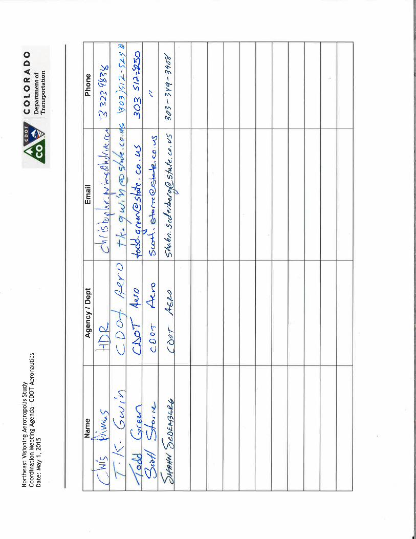
Project: Northeast Quadrant Visioning Aerotropolis Study
Subject: Coordination Meeting—CDOT Aeronautics
Date: May 1, 2015
Location: CDOT Aeronautics
Attendees: T.K. Gwin (Aeronautics); Todd Green (Aeronautics); Scott Storie (Aeronautics); Shahn Sederberg (Aeronautics); Jay Hendrickson (CDOT); Chris Primus (HDR);
1. Introductions were made.
2. Jay Hendrickson described the study background and purpose. He confirmed it was an FHWA grant that funds this study.
3. The CDOT Aeronautics Division works with FAA and CDOT Grants for region airport activities. They thought that FHWA might be open to deadline extension given the short time frame to conduct the study, and that FHWA would like to be sure that the study product is not rushed.
4. The CDOT Aeronautics staff has a good understanding of DIA and Front Range airports and their needs and plans. They also have a good understanding of the FAA and its perspectives. They confirmed that they would be willing to support the study as a neutral party. They could help review the study and its recommendations regarding aviation issues. CDOT Aeronautics has a conference room that can accommodate 35 people that they could make available for committee meetings.
5. Shahn Sederberg handles communications for CDOT Aeronautics and confirmed that he is in close coordination with the communications group at CDOT Headquarters under Amy Ford.
6. CDOT Aeronautics confirmed that they can participate in the Study Review Committee meeting during the visioning workshop on May 7, 2015. They will also participate in the second Study Review Committee meeting on May 27, 2015, which will focus on briefings on activities and plans of agencies in the area around DIA.
7. CDOT Aeronautics has a good understanding of the development requirements around airports so that new developments do not interfere with airport operations.
8. CDOT Aeronautics recently conducted studies regarding the economic impact of airports. The studies identified that the impact of airports vary significantly by region and by county. The final report was never prepared but Aeronautics will send HDR the summary.
9. CDOT Aeronautics has good relationship with the FAA in Colorado and nationally. The relevant division in Colorado for this study is the Denver Airport District Office of the FAA. John Bauer is the main contact. The FAA focuses on airspace and airport accesses and their role is to make sure these are protected for the aviation industry. CDOT

Northeast Visioning Aerotropolis Study Coordination Meeting Notes—CDOT Aeronautics Date: May 1, 2015
Aeronautics recommended that the Denver Airport District Office of the FAA be invited to participate in the Aerotropolis study.
10. The FAA will make final determination on airport access and developments around airports. If they have an early understanding of how plans are developed, then it is easier for them to have a perspective to understand the needs and plans and better able to work with Washington, DC, to get the approval process completed.
11. Peña Boulevard has recently been under scrutiny for its non-aviation use. The CDOT Aeronautics Division issued a $3 million grant to fund maintenance and operations of Peña Boulevard during an interim period, while negotiations with neighboring jurisdictions were made for future maintenance and operations funding needs.
12. The FAA has been clarifying its rules regarding various guidances. A new guidance was just issued regarding the rule concerning non-aviation uses of airport accesses. CDOT Aeronautics will send a Web link of this new guidance to HDR.
13. As a point of clarification, any revenue raised on an airport (for example, tax on aviation fuel and, many times, tax on airport retail sales) is considered airport revenue and must be used for airport purposes. The FAA makes determinations on a case-by-case basis on new airport access and use of airport funds.
14. The FAA may want to participate in the May 27, 2015, briefing workshop for the Study Review Committee. They will send the contact information and Chris Primus will invite them to a conference call next week (week of 5/4) apprising them of the study and invite them to the visioning workshop and the briefing workshop.
15. Regarding the study area for the Aerotropolis study, FAA did not have any immediate suggestions, but thought that the study team’s economist may have perspectives on the appropriate area. They also suggested that we should be aware of the area each of the five major stakeholders has within our final study area, in case this becomes a point of contention.
2

Meeting Agenda
Project: Aerotropolis Visioning Study
Subject: Coordination Meeting—E-470 Authority
Date: April 30, 2015
Location: Conference Call 866-994-6437 Code 8971215
1. Introductions
2. Study Background / Grant
3. Study Schedule
4. Study Methodology and Outcome
5. Coordination Opportunities
6. Study Committee Structure
a. Steering Committee
b. Study Review Committee (SRC)
7. SRC
a. Kick-off Visioning Workshop May 7 1:30
b. Briefing Meeting May 27 9:00
8. Available GIS and other data
9. Next Steps and Action Items

Nor
thea
st V
isio
ning
Aer
otro
polis
Stu
dy
Coor
dina
tion
Mee
ting
Age
nda
Date
: Ap
ril 3
0, 2
015
Dr
aft
Sche
dule
20
15
Task
s A
M
J J
A S
O
N
D
Proj
ect
Man
agem
ent
St
eeri
ng C
omm
itte
e
Stud
y Re
view
Com
mit
tee
Co
ncep
t De
velo
pmen
t an
d Vi
sion
ing
Init
ial S
cena
rios
Eco
nom
ic A
naly
sis
Re
fine
d Sc
enar
ios
Econ
omic
An
alys
is
Find
ings
& N
ext
Step
s
Fina
l Doc
umen
t
2

FINAL Meeting Notes
Project: E-470 Authority
Subject: Coordination Meeting—E-470 Authority
Date: April 30, 2015
Location:
Conference Call
Attendees: Stan Koniz (E-470); Jason Myers (E-470); Jaime Heitman (E-470); Jay Hendrickson(CDOT); Chris Primus (HDR)
1. Introductions were made.
2. Jay Hendrickson provided an overview of the study, background, and grant.
3. It was clarified that the planned outcome of the study is to investigate the infrastructure that is needed to support the development in the area around DIA and that the study will articulate the economic benefits of a collaborative approach.
4. It was questioned how this study relates to the current study of Pena Boulevard and it was confirmed that the two studies will be in close coordination. The Pena Boulevard study will recommend alternatives by the end of the year. Those will help inform the infrastructure needs for the Aerotropolis Study.
5. The area for the Aerotropolis Study will be I-70 on the south, US-85 and I-76 on the West, Adams County Line on the north and the eastern boundary will be to the east of Front Range Airport. It was noted that E-470 is central to this area.
6. E-470 has recently completed a Traffic and Revenue Study in late 2014. It is on the website under the Investor Relations Tab. It identifies the need for widening in the southeast part of their corridor between Parker and Quincy in the relative near term. Further out, in the 2025 /2035 timeframe, it identifies more widening to the north of Quincy. However, no widening in the twenty year time frame is anticipated at this point near Pena Boulevard. Of course, plans are re-visited as development occurs and if additional development occurs near Pena Boulevard in a closer timeframe, E-470 will adjust plans accordingly.
7. Regarding interchanges, Quebec opened last year in the northern segment of the E-470 corridor. Another interchange of note is the 6th Avenue alignment. It is close to the southern boundary for this Aerotropolis Study area. The interchange today is a dead end, but Aurora is proceeding with a 6th Avenue Parkway Extension to that interchange in the next three to five years. A new interchange at 88th Avenue has been identified for the 2025 / 2035 Horizon Year Time Span. E-470 Authority completed an Interchange Study in 2012 that was conducted by CDM Smith. That has information about interchanges and the tolling and revenue impacts as these new interchanges come online. Their studies involve land use projections that are updated by discussions with the local jurisdictions and developers in the areas surrounding the E-470 Corridor.

Northeast Visioning Aerotropolis Study Coordination Meeting Notes—E-470 Date: April 30, 2015
2
8. Chris further described the Study Review committee and the steering committee. The E-470 authority would be a welcome participant at the study review committee. The first study review committee will be a Visioning Workshop on May 7th and the second study review committee will be a briefing meeting on May 27th. Jason and Stan confirmed that they can attend the two meetings as well as subsequent study review committees.
9. The Steering Committee, which is composed of major stakeholders of Adams, City of Aurora, City of Brighton, Commerce City, and the City and County of Denver, will be in an Advisory Committee with one seat at the table per jurisdiction. It was noted four out of the five members of the Steering Committee are on the E-470 board. The only one not on the board is The City and County of Denver.
10. Beyond the information on the web, GIS information is available regarding E-470 and their plans. Jason will determine the GIS contact for this study.

Meeting Agenda
Project: Aerotropolis Visioning Study
Subject: Coordination Meeting—DRCOG
Date: April 30, 2015
Location: DRCOG
1. Introductions
2. Study Background / Grant
3. Study Schedule
4. Study Methodology and Outcome
5. Coordination Opportunities
6. Study Committee Structure
a. Steering Committee
b. Study Review Committee (SRC)
7. SRC
a. Kick-off Visioning Workshop May 7 1:30
b. Briefing Meeting May 27 9:00
8. Available GIS and other data
9. Next Steps and Action Items

Nor
thea
st V
isio
ning
Aer
otro
polis
Stu
dy
Coor
dina
tion
Mee
ting
Age
nda
Date
: Ap
ril 3
0, 2
015
Dr
aft
Sche
dule
20
15
Task
s A
M
J J
A S
O
N
D
Proj
ect
Man
agem
ent
St
eeri
ng C
omm
itte
e
Stud
y Re
view
Com
mit
tee
Co
ncep
t De
velo
pmen
t an
d Vi
sion
ing
Init
ial S
cena
rios
Eco
nom
ic A
naly
sis
Re
fine
d Sc
enar
ios
Econ
omic
An
alys
is
Find
ings
& N
ext
Step
s
Fina
l Doc
umen
t
2

FINAL Meeting Notes
Project: Colorado Aerotropolis Visioning Study
Subject: Coordination Meeting—CDOT Aeronautics
Date: April 30, 2015
Location:
DRCOG
Attendees: Doug Rex (DRCOG); Daniel Jerrett (DRCOG); Steve Cook (DRCOG); Jay Hendrickson (CDOT); Chris Primus (HDR); Keith Borsheim (DRCOG)
1. Introductions were made.
2. Jay Hendrickson described the background and purpose of the study.
3. Steve Cook mentioned that this grant has been in the TIP for a couple of years under the TCSP Program funds. DRCOG has not heard any activity on it recently.
4. Steve also mentioned that the Aerotropolis term is in the MAP-21 legislation under the Freight section, Section 11.15, National Freight Policy, under establishing a national freight network, including intermodal connectors and aerotropolis transportation systems.
5. DRCOG asked if the Peña Boulevard study is separate from the Aerotropolis study. It is separate but integral. The Aerotropolis study team will be in close coordination with the Pena Boulevard project team as alternatives are developed for Pena Boulevard. The Peña Boulevard study is in the same time frame to complete and identify alternatives by the end of 2015.
6. Chris Primus provided a description of the Aerotropolis study committee structure and listed the major stakeholders of Adams County, Aurora, Brighton, Commerce City, and Denver.
7. Jay described the first Study Review Committee meeting on May 7, 2015, which is a visioning workshop. The second Study Review Committee meeting on May 27, 2015, will be a briefing meeting. DRCOG is welcome to participate in and send representatives to the Study Review Committee meetings. At the briefing meeting on May 27, DRCOG is welcome to describe their plans and visions and support for the Aerotropolis Study.
8. Chris described the planned outcome of the study, which will not be a plan, per se, of determining future land use patterns and future roadway network, but rather it will be an economic analysis of the benefit of developing an aerotropolis compared to a current trends development scenario.
9. Chris further said that the economic analysis may reallocate employment and some residential to the aerotropolis area compared to the standard 2040 allocation data set of DRCOG. He suggested that the study team might use the DRCOG travel demand model to do this. The HDR team is accustomed to operating the COMPASS model. He asked Daniel Jerrett how land use could be redistributed to reflect aerotropolis-types of development patterns as a scenario exercise.

Colorado Aerotropolis Visioning Study Coordination Meeting Notes—DRCOG Date: April 30, 2015
2
10. After some discussion and description of Urban Sims and its capabilities, Urban Sims probably is not the right tool. Instead Daniel recommended IMPLAN or REMI. He noted the main input to Urban Sims—the regional control totals at the county level, as well as the zoning—is a critical input. The IMPLAN and REMI tools produce number of jobs created and cost. He also suggested that the zones in the aerotropolis area might need to be split.
11. DRCOG also suggested that if we, for a scenario analysis, look at an aerotropolis that attracts more employment than the current regional control total for 2040, then the Aerotropolis study team should coordinate with the state demographer and DRCOG to be sure the new total is in line and within reason of migration levels.
12. Chris asked DRCOG about its sustainability initiative. There was a specific grant, the SCI Sustainability Grant that is in its final stages that has looked at sustainability measures particularly near new station areas. The 61st and Peña station may have been one of those stations.
13. The other aspect of sustainability at DRCOG is the Council of Governments general policy for sustainability. The current DRCOG Board varies in its support for sustainability as a regional policy.
14. Daniel said he could have a conference call with the HDR team economist to further explore the technical aspect of the economic analysis. He noted that he and the travel modeling staff at DRCOG are completely booked for several months into the fall. The ability for DRCOG staff to run scenarios is limited and probably not possible in the time frame of the Aerotropolis study.
15. Chris will send invitation to the Study Review Committee meetings to DRCOG staff.


Northeast Visioning Aerotropolis Study Coordination Meeting Agenda Date: April 30, 2015
Meeting Agenda
Project: Aerotropolis Visioning Study
Subject: Coordination Meeting—DRCOG
Date: April 30, 2015
Location: DRCOG
1. Introductions
2. Study Background / Grant
3. Study Schedule
4. Study Methodology and Outcome
5. Coordination Opportunities
6. Study Committee Structure
a. Steering Committee
b. Study Review Committee (SRC)
7. SRC
a. Kick-off Visioning Workshop May 7 1:30
b. Briefing Meeting May 27 9:00
8. Available GIS and other data
9. Next Steps and Action Items
1

Nor
thea
st V
isio
ning
Aer
otro
polis
Stu
dy
Coor
dina
tion
Mee
ting
Age
nda
Date
: Ap
ril 3
0, 2
015
Dr
aft
Sche
dule
20
15
Task
s A
M
J J
A S
O
N
D
Proj
ect
Man
agem
ent
St
eeri
ng C
omm
itte
e
Stud
y Re
view
Com
mit
tee
Co
ncep
t De
velo
pmen
t an
d Vi
sion
ing
Init
ial S
cena
rios
Eco
nom
ic A
naly
sis
Re
fine
d Sc
enar
ios
Econ
omic
An
alys
is
Find
ings
& N
ext
Step
s
Fina
l Doc
umen
t
2

FINAL Meeting Notes
Project: Colorado Aerotropolis Visioning Study
Subject: Coordination Meeting—DRCOG
Date: April 30, 2015
Location:
DRCOG
Attendees: Doug Rex (DRCOG); Daniel Jerrett (DRCOG); Steve Cook (DRCOG); Jay Hendrickson (CDOT); Chris Primus (HDR); Keith Borsheim (DRCOG)
1. Introductions were made.
2. Jay Hendrickson described the background and purpose of the study.
3. Steve Cook mentioned that this grant has been in the TIP for a couple of years under the TCSP Program funds. DRCOG has not heard any activity on it recently.
4. Steve also mentioned that the Aerotropolis term is in the MAP-21 legislation under the Freight section, Section 11.15, National Freight Policy, under establishing a national freight network, including intermodal connectors and aerotropolis transportation systems.
5. DRCOG asked if the Peña Boulevard study is separate from the Aerotropolis study. It is separate but integral. The Aerotropolis study team will be in close coordination with the Pena Boulevard project team as alternatives are developed for Pena Boulevard. The Peña Boulevard study is in the same time frame to complete and identify alternatives by the end of 2015.
6. Chris Primus provided a description of the Aerotropolis study committee structure and listed the major stakeholders of Adams County, Aurora, Brighton, Commerce City, and Denver.
7. Jay described the first Study Review Committee meeting on May 7, 2015, which is a visioning workshop. The second Study Review Committee meeting on May 27, 2015, will be a briefing meeting. DRCOG is welcome to participate in and send representatives to the Study Review Committee meetings. At the briefing meeting on May 27, DRCOG is welcome to describe their plans and visions and support for the Aerotropolis Study.
8. Chris described the planned outcome of the study, which will not be a plan, per se, of determining future land use patterns and future roadway network, but rather it will be an economic analysis of the benefit of developing an aerotropolis compared to a current trends development scenario.
9. Chris further said that the economic analysis may reallocate employment and some residential to the aerotropolis area compared to the standard 2040 allocation data set of DRCOG. He suggested that the study team might use the DRCOG travel demand model to do this. The HDR team is accustomed to operating the COMPASS model. He asked Daniel Jerrett how land use could be redistributed to reflect aerotropolis-types of development patterns as a scenario exercise.

Colorado Aerotropolis Visioning Study Coordination Meeting Notes—DRCOG Date: April 30, 2015
10. After some discussion and description of Urban Sims and its capabilities, Urban Sims probably is not the right tool. Instead Daniel recommended IMPLAN or REMI. He noted the main input to Urban Sims—the regional control totals at the county level, as well as the zoning—is a critical input. The IMPLAN and REMI tools produce number of jobs created and cost. He also suggested that the zones in the aerotropolis area might need to be split.
11. DRCOG also suggested that if we, for a scenario analysis, look at an aerotropolis that attracts more employment than the current regional control total for 2040, then the Aerotropolis study team should coordinate with the state demographer and DRCOG to be sure the new total is in line and within reason of migration levels.
12. Chris asked DRCOG about its sustainability initiative. There was a specific grant, the SCI Sustainability Grant that is in its final stages that has looked at sustainability measures particularly near new station areas. The 61st and Peña station may have been one of those stations.
13. The other aspect of sustainability at DRCOG is the Council of Governments general policy for sustainability. The current DRCOG Board varies in its support for sustainability as a regional policy.
14. Daniel said he could have a conference call with the HDR team economist to further explore the technical aspect of the economic analysis. He noted that he and the travel modeling staff at DRCOG are completely booked for several months into the fall. The ability for DRCOG staff to run scenarios is limited and probably not possible in the time frame of the Aerotropolis study.
15. Chris will send invitation to the Study Review Committee meetings to DRCOG staff.
2


FINAL Meeting Notes
Project: Aerotropolis Visioning Study
Subject: Coordination Meeting—RTD
Date: April 29, 2015
Attendees: Bill Van Meter (RTD) ); Jay Hendrickson (CDOT); Chris Primus (HDR)
1. Introductions were made.
2. Jay Hendrickson provided an overview of the study, background, and grant.
3. Bill Van Meter provided a background to the development of the East Corridor stations. The Airport and 40th station has always been identified as a station on the FasTracks plan. As planning for the FasTracks corridors progressed, Denver along with DIA wanted two more stations along the East Corridor line. RTD due to funding constraints said that any additional stations would need to be funded by Denver. RTD’s analysis demonstrated that one additional station would not require additional fleet, but two additional stations would require additional fleet. The agreement with Denver was that they would contribute accordingly if two stations were added.
4. Denver has proceeded with having a station built at 61st and Pena as one of the first additional stations. The other additional station is located on the east-west portion of the east corridor line near E-470. Aurora has been somewhat supportive of these additional stations. Actually, Aurora’s preference was the other station in contrast to 61st and Pena, since it provides better access for Aurora developments.
5. RTD’s analysis showed that there is a need for 800 parking spaces at the 61st & Pena Station and that is in the agreement with Denver that the parking be provided. It was mentioned that parking is potential revenue generator. A parking facility can charge airport travelers for parking and help generate revenue for the development.
6. Regarding long term visions, RTD has been active in the recent past as a joint sponsor for the Inter-Connectivity Study, which studied High Speed Rail Lines through the state and how they are connected in the RTD Region. The ICS Study as one of its alternatives envisioned a High Speed Rail Line North-South along the Front Range, with a suburban station on both the north and south of the suburban areas and routing east around the metropolitan with a station at DIA.
7. Another study which is looking at the long term (post-FasTracks) is the NATE2 Study, the Northeast Area Transportation Evaluation study. It is primarily looking at the corridor between the Downtown area and the City of Brighton. The corridors under review are the US-85 Corridor, the SH-2 Corridor, and the I-76 corridor. Brighton has bene interested in a rail line on one of these corridors. As the FasTracks plans has progressed and rail corridors have been planned and designed, there is a better awareness of the cost of rail lines. For that reason, the Nat2Study has focused on BRT as the mode of choice for the corridor up to Brighton. The study has identified that BRT arterial corridors through the study area include the SH-7 Corridor and the 120th
1

Northeast Visioning Aerotropolis Study Coordination Meeting Notes—RTD Date: April 29, 2015
2
Avenue corridor serve the east-west area near DIA in the Commerce City / Brighton areas.
8. RTD will be happy to be a coordinating agency and attend the study review committee meetings. Bill suggested that two groups might have good input to be representatives of RTD. One would be the service planning group and the other would be Bill’s long range planning group. Depending on availability, Bill would ask staff from these two groups of RTD to attend the study review committees.
9. Bill will also provide GIS files for the East Corridor and the NATE 2 Study. He suggested a better source for the ICS alignments is David Krutsinger, at CDOT’s Division of Transit and Rail.
10. Bill mentioned that they have current staff skills and capacity for planning, designing, and delivering rail lines. He was unsure what RTD would plan for post-FasTracks with that in conjunction with CDOT DTR. There may be some Rail opportunities statewide where his staff participates in those planning and design meetings.

Meeting Agenda
Project: Aerotropolis Visioning Study
Subject: Coordination Meeting—Pena Boulevard Study
Date: Wednesday, April 22, 2015
Location: WorldPort
1. Introductions
2. Study Background / Grant
3. Study Schedule
4. Study Methodology and Outcome
5. Coordination Opportunities
6. Study Committee Structure
a. Steering Committee
b. Study Review Committee (SRC)
7. SRC
a. Kick-off Visioning Workshop May 7
b. Briefing Meeting May 22 or 27
8. Available GIS and other data
9. Next Steps and Action Items

Nor
thea
st V
isio
ning
Aer
otro
polis
Stu
dy
Coor
dina
tion
Mee
ting
Age
nda—
Da
te:
Apri
l 22,
201
5
Draf
t Sc
hedu
le
2015
Ta
sks
A M
J
J A
S O
N
D
Pr
ojec
t M
anag
emen
t
Stee
ring
Com
mit
tee
St
udy
Revi
ew C
omm
itte
e
Conc
ept
Deve
lopm
ent
and
Visi
onin
g
Init
ial S
cena
rios
Eco
nom
ic A
naly
sis
Re
fine
d Sc
enar
ios
Econ
omic
An
alys
is
Find
ings
& N
ext
Step
s
Fina
l Doc
umen
t
2

FINAL Meeting Notes
Project: Northeast Quadrant Visioning Aerotropolis Study
Subject: Coordination Meeting— Pena Boulevard Study
Date: 8:30, April 22, 2015
Location: WorldPort
Attendees:
Bill Poole (DIA); Suzanne Culin (DIA); Dave LaPorte (DIA/AIM); Dan Poremba (DIA); Mark Schaefer (AECOM); Tom Reed (DIA); Brandon Howes (DIA) Amy Raaz (DIA); Kendall Peterson (URS); Rick Pilgrim (HDR); Evan Dryer (Mayor’s Office) Jay Hendrickson (CDOT); Kip Cheroutes (LXC Strategies); Chris Primus (HDR); Rick Pilgrim (HDR).
1. Introductions were made.
2. Jay Hendrickson provided the background to the study.
3. The Pena Boulevard effort is a paramount issue for planning the infrastructure around the DIA facility and it is important that the two studies are synchronous with each other in terms of outreach and messaging. However, the Aerotropolis Study has a neutral party CDOT as its lead, and there can be some distance between the two studies.
4. The Aerotropolis Study has a planned committee structure of a steering committee and study review committee. The steering committee will be a guidance committee or an advisory committee with each of the major stakeholders having one seat at the table for equitable representation. The five major stakeholders are Adams County, City of Aurora, City of Brighton, Commerce City and Denver. It was questioned if DIA would have a seat at the table as well, and at the one-on-ones, it has been suggested that Denver represent DIA. However, if DIA would like to make their case at the visioning workshop for a seat at the table, that may be accepted by the major stakeholders.
5. The Aerotropolis Study has scheduled a kick-off visioning workshop on May 7th. Chris Primus said that the second meeting of the Aerotropolis Study Review Committee would be a briefing session to where various activities and studies, that are active around the DIA area, would each provide an overview of their study. The overviews would briefly describe the schedule and potential outcome to the larger study review committee stakeholders. This workshop is to be scheduled in late May, will be a good forum for Pena Boulevard Study team to describe their plans and activities for the study.
6. Tom Reed provided the background to the Pena Boulevard Study. As development and growth has occurred, an increasing amount of traffic on Pena Boulevard is not destined to/from the airport. This violates the funding agreements that the airport maintains with the FAA, which assures airport revenue is not diverted from airport uses.

Northeast Visioning Aerotropolis Study Coordination Meeting Notes—Pena Boulevard Study Date: April 22, 2015
7. The FAA’s position is that as non-airport traffic begins to use the start of Pena Boulevard that other jurisdictions contribute towards the costs for operating and maintaining the facility and future capacity improvements. This issue of non-compliance is a very serious one. Potentially the FAA could halt all federal funds that are used by DIA. In 2013, the CDOT division of Aeronautics received a three million dollar grant to operating maintenance costs of Pena Boulevard. This is an interim funding. This grant runs out at the end of 2015. At the end of 2015, more interim funding will need to be identified for operations and maintenance of Pena Boulevard.
8. As this became an issue, the airport hired FHU to study the traffic on Pena Boulevard. The study collected traffic counts and used the DRCOG model as well as Bluetooth data on traffic patterns to come up with estimated traffic on Pena that was airport destined versus non-airport use. The study determined that approximately 38% was non-airport use on the southern section of Pena between 56th Avenue and I-70. During the study period, a task force was formed with the surrounding jurisdictions to understand the issues that regarding the non-airport use of Pena Boulevard. The task force met three or four times during the course of the study. After the FHU study, which ended in 2012, URS was hired to further study the traffic patterns to further define the problems and this time develop alternatives.
9. The URS study must identify a solution that is acceptable to DIA, Denver, and the FAA. The solutions could be short or long term. It may specify how the jurisdictions contribute to the solutions. In the meantime, the development and growth surrounding DIA has increased. And as a result, the traffic on Pena has continued to increase as well. It was noted that due to the increasing traffic, there is rising concerns about Pena Boulevard. The FAA requires the level service C on airport access road. And traffic conditions are verging toward level of service “D” conditions.
10. At the end of 2015, DIA, Denver, and FAA must have identified alternatives that are satisfactory. But preliminary thoughts on possible alternatives not yet internally vetted include: Physical alternatives could include additional lanes or additional/widened arterials. The physical alternatives could also include Collector-Distributor (CD) roads. Actually, CD roads were identified as part of the original design plan for DIA back in the early 1990’s. The CD road as envisioned would serve local traffic along the Pena corridor, and Pena Boulevard would serve as an expressway into DIA. Current cost estimates for a CD road infrastructure would range from sixty million to one-hundred million dollars. Another category of alternatives would be operational alternatives. This would include tolls or peak hour restrictions or other options. The tolling options could take form of various permutations but would serve to both raise revenue and also meter traffic. The third category of alternatives would be financial or institutional alternatives.
11. It was questioned if the original airport plans had called for CD roads, they would have been paid with the same airport bond revenue as the rest of the airport infrastructure. And if that was the case, could the same revenue structure pay for the CD roads today? It was so many years ago, it was not known the logic of how the CD roads were paid for. It could have been expected to be paid for by City and County general funds. Or perhaps, they did not understand the consequences and the restrictions on that revenue.
2

Northeast Visioning Aerotropolis Study Coordination Meeting Notes—Pena Boulevard Study Date: April 22, 2015
12. It was suggested that this question may arise again from the participants of the Pena Boulevard study or the Aerotroplis study. There may be a need to reconstruct the funding plan for the CD roads back in 1992.
13. The URS study has not met with the task force yet. The Pena Boulevard team will develop the range of alternatives and present them to the stakeholders. This is not scheduled yet. The Pena study team will begin the outreach effort soon. They are refining the messaging and after further internal review, they will start to engage the stakeholders.
14. The outreach plan of the Pena Boulevard study team is to engage the neighboring jurisdictions. It will be largely the same group as the Aerotroplis study has engaged in one-on-one sessions over the last two or three weeks. After the Pena Boulevard team engages the technical staff, then the outreach plan will broaden to reach elected officials, the public, and the media.
15. In summary Jay Hendrickson asked for their perspectives on the ideal outcome of the Aerotropolis Study. It was suggested that the Aerotropolis study identify an overall plan for the roadway network; this would be beneficial to help offload traffic from Pena Boulevard. It was also suggested that the public relations be in coordination and a meeting should be set with the DIA PR team, CDOT and the study team’s PR individuals.
3


Northeast Visioning Aerotropolis Study Coordination Meeting Notes—I-70 East Project Date: April 20, 2015
FINAL Meeting Notes
Project: Northeast Quadrant Visioning Aerotropolis Study
Subject: Coordination Meeting—I-70 East Project
Date: 2:00 Monday, April 20, 2015
Location:
Atkins
Attendees: Peter Kozinski (CDOT); Vanessa Henderson (CDOT); Carrie Wallis (Atkins); Jay Hendrickson (CDOT); Chris Primus (HDR); Rick Pilgrim (HDR)
1. Introductions were made.
2. Jay Hendrickson provided the background to the study.
3. Carrie Wallis provided a brief overview of the status of the I-70 East study. The terminus on the east side is Tower Road. The project plans two managed lanes in each direction, between I-25 and Tower. Phase I would have one tolled lane in each direction between I-25 and I-225. In Phase II, the lanes are extended further east. Direct connects between the managed lanes and Pena Blvd are not planned at this time. Their designs do not preclude a direct connect, but it is not being directly designed at this point in time. Under the Phase II two managed lanes, it is possible one of the lanes connects to/from a direct connection to Pena Blvd and the other lane merges to/from the mainline.
4. The Supplemental Draft EIS is online and has the description of the eastern end that is relevant to the Aerotroplis Study.
5. Regarding interchanges, their Phase I has ramp modifications only, in the vicinity of Quebec and Tower. They did note that Phase II has reconstructions of the inter-changes including Havana. The others are re-constructed with as diamond interchanges. The Tower Road interchange does not have a major reconstruction in Phase II.
6. The I-70 East study is using 2035 as a horizon year partially because the 2040 modeling is not available for project use from DRCOG.
7. Chris Primus briefly described the Aerotropolis study’s committee structure. He said a Kick-off Visioning Workshop of the Study Review Committee (SRC) will be held on May 7. The next meeting of the SRC, in mid- to late May, will be a “Briefing” meeting where various entities and studies active in the DIA area will each provide brief
1

Northeast Visioning Aerotropolis Study Coordination Meeting Notes—I-70 East Project Date: April 20, 2015
overviews of their efforts. Peter Kozinski agreed that the I-70 East project team could provide a brief overview at the “Briefing” SRC meeting.
2


Meeting Agenda
Project: Aerotropolis Visioning Study
Subject: Coordination Meeting—MDEDC
Date: Friday, April 17, 2015
Location: Denver Metro Chamber of Commerce
1. Introductions
2. Study Background / Grant
3. Study Schedule
4. Study Methodology and Outcome
5. Coordination Opportunities
6. Study Committee Structure
a. Steering Committee
b. Study Review Committee (SRC)
7. SRC
a. Kick-off Visioning Workshop May 7
b. Briefing Meeting May 21 or 22
8. Available GIS and other data
9. Next Steps and Action Items

Nor
thea
st V
isio
ning
Aer
otro
polis
Stu
dy
Coor
dina
tion
Mee
ting
Age
nda—
Da
te:
Frid
ay,
Apri
l 17,
201
5
2
Draf
t Sc
hedu
le
2015
Ta
sks
A
M
J J
A
S
O
N
D
Proj
ect
Man
agem
ent
St
eeri
ng C
omm
itte
e
Stud
y Re
view
Com
mit
tee
Co
ncep
t De
velo
pmen
t an
d Vi
sion
ing
Init
ial S
cena
rios
Eco
nom
ic A
naly
sis
Re
fine
d Sc
enar
ios
Econ
omic
An
alys
is
Find
ings
& N
ext
Step
s
Fina
l Doc
umen
t