cockburn river groundwater and surface water connectivity
TRANSCRIPT

Cockburn River groundwater and surface water connectivity study – progress report
A study assessing how groundwater extraction influences surface water pools in the Cockburn River
August 2021
NSW Department of Planning, Industry and Environment | dpie.nsw.gov.au

Published by NSW Department of Planning, Industry and Environment
www.dpie.nsw.gov.au
Title: Cockburn River groundwater and surface water connectivity study – progress report
First published: August 2021
Department reference number: PUB21/430
© State of New South Wales through Department of Planning, Industry and Environment 2021. You may copy, distribute, display, download and otherwise freely deal with this publication for any purpose provided you attribute the Department of Planning, Industry and Environment as the owner. However, you must obtain permission if you wish to charge others for access to the publication (other than at cost); include the publication in advertising or a product for sale; modify the publication; or republish the publication on a website. You may freely link to the publication on a departmental website.
Disclaimer: The information contained in this publication is based on knowledge and understanding at the time of writing (August 2021) and may not be accurate, current or complete. The State of New South Wales (including the NSW Department of Planning, Industry and Environment), the author and the publisher take no responsibility, and will accept no liability, for the accuracy, currency, reliability or correctness of any information included in the document (including material provided by third parties). Readers should make their own inquiries and rely on their own advice when making decisions related to material contained in this publication.

Cockburn River groundwater and surface water connectivity study – progress report
Acknowledgment of Country The NSW Government acknowledges Aboriginal people as Australia’s first people practicing the
oldest living culture on earth and as the Traditional Owners and Custodians of the lands and
waters. We recognise the intrinsic connection of Traditional Owners to Country and acknowledge
their contribution to the management of landscapes, water and other natural resources across
NSW.
NSW Department of Planning, Industry and Environment understands the need for consultation
and inclusion of Traditional Owner knowledge, values and uses in water planning to ensure we are
working towards equality in objectives and outcomes. The department is committed to continuing
future relationships and building strong partnerships with Aboriginal people.
NSW Department of Planning, Industry and Environment | PUB21/430 | i

Cockburn River groundwater and surface water connectivity study – progress report
Contents Introduction ........................................................................................................................................1
Project intent.....................................................................................................................................1
Context of this report ........................................................................................................................1
Methodology.......................................................................................................................................2
Site selection ....................................................................................................................................2
Surface water field program .............................................................................................................4
Groundwater field program ..............................................................................................................4
Analysis of connection......................................................................................................................5
Data collected to date........................................................................................................................5
River pools........................................................................................................................................5
Groundwater bores...........................................................................................................................8
Next steps ...........................................................................................................................................8
Appendix A – Groundwater bore locations ....................................................................................9
Site A – Pool 1 and Pool 2 ...............................................................................................................9
Site B – Pool 3................................................................................................................................10
Site C – Pool 4................................................................................................................................11
Appendix B – Sample of monitoring bore hydrographs .............................................................12
GW060043 .....................................................................................................................................12
GW013404 .....................................................................................................................................12
GW047919 .....................................................................................................................................13
GW093110 – MB1..........................................................................................................................13
GW093111 – MB2..........................................................................................................................14
NSW Department of Planning, Industry and Environment | PUB21/430 | ii

Cockburn River groundwater and surface water connectivity study – progress report
Introduction Pools in river systems provide valuable ecological services, including providing refugia for aquatic
biota during low and no flow conditions, frequently experienced in drought.
The Cockburn River supports several high ecological value assets that are dependent on the
sustainability of river pools, including endangered populations of Eel-tailed catfish and Murray cod, which are listed as vulnerable. A key threatening process (listed in the Threatened Species
Conservation Act 1995) for these fish communities is the alteration to natural flow regimes of rivers
and streams.
The pools and the underlying aquifer associated with the Cockburn River are also an important
source of water for licence holders, landholders and communities, providing for basic landholder
rights and other productive uses. Extraction from the unregulated Cockburn River water source is managed under the Water Sharing Plan for the Namoi and Peel Unregulated River Water Sources
2012 and is linked to flow in the Cockburn River.
Along with surface water, groundwater is also used for productive purposes. Groundwater access
from the Cockburn River Alluvium (within the Peel Alluvium Water Source) is managed under rules set out in the Water Sharing Plan for the Namoi Alluvial Groundwater Sources 2020. While there
are currently no daily access rules for groundwater licences in the Cockburn River Alluvium
Management Zone, this plan may be amended to establish these access rules after 1 July 2022.
We know from the department’s 2019 study of ‘A Review of Groundwater-Surface Water
Connectivity in the Cockburn Alluvium Management Zone’ that the groundwater in the Cockburn
River Alluvium is highly connected to the Cockburn River and that groundwater extraction has the
potential to impact surface water flows and pool volumes in the Cockburn River.
This study will help us understand the hydrological conditions in the pools under varying discharge
events and their connection to the underlying aquifer, which will be considered in determining if
daily access rules for groundwater extraction are appropriate.
Project intent The aim of this project is to assess how groundwater extraction influences water levels in the river
and river pool habitats in the Cockburn River.
The scope of this project is limited to understanding the effect of groundwater pumping on pool
water levels and the hydraulics of these effects.
This project will answer the following research questions:
1. How does groundwater extraction influence surface water pool volumes?
2. How does this affect the water quality in the river pools in the Cockburn River?
The information collected in this project will also be used in the Peel Alluvium numerical model that
the department is currently developing. The model will allow the department to look at surface
water/groundwater interactions in the Peel Alluvium, including looking at the effects of different
options for access rules in the Cockburn River Alluvium Management Zone for further
consideration.
Context of this report This report outlines progress to date and describes:
the sites selected for the study
the information the department is collecting and analysing
what information has been collected to date
NSW Department of Planning, Industry and Environment | PUB21/430 | 1

Cockburn River groundwater and surface water connectivity study – progress report
next steps
The project findings will be provided in a final report, expected to be delivered by the end of 2021.
Methodology
Site selection We selected four river pools and 28 nearby groundwater bores to investigate the interaction
between groundwater extraction and the effects on habitats and water quality in surface water
pools.
The four river pools selected (Figure 1):
are easy to access
have healthy riparian vegetation (riparian vegetation provides bank stability, habitat, shade
and food for native fish)
have a depth and size sufficient to determine pool persistence during drought conditions
The pool surface water level changes, daily flow, rainfall and evaporation data was monitored for
the period December 2019 to April 2021.
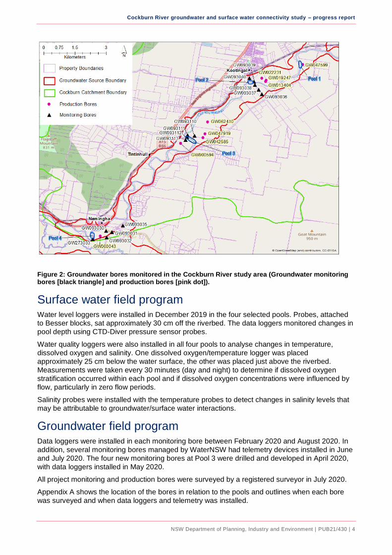
The 28 groundwater bores (Figure 2) are near the selected river pools. These included existing
monitoring bores, active and inactive production bores, plus four newly drilled monitoring bores.
We monitored groundwater level change in conjunction with extraction volumes from irrigation
activities and production bore drawdown levels.
All pools and groundwater bores were surveyed to a standard height datum, metres Australian
Height Datum (mAHD), to allow comparative analysis of water levels.
NSW Department of Planning, Industry and Environment | PUB21/430 | 2

Cockburn River groundwater and surface water connectivity study – progress report
Figure 1: River pools monitored in the Cockburn River study area. (River pools are the green circles)
NSW Department of Planning, Industry and Environment | PUB21/430 | 3
Cockburn River groundwater and surface water connectivity study – progress report
Figure 2: Groundwater bores monitored in the Cockburn River study area (Groundwater monitoring bores [black triangle] and production bores [pink dot]).
Surface water field program Water level loggers were installed in December 2019 in the four selected pools. Probes, attached
to Besser blocks, sat approximately 30 cm off the riverbed. The data loggers monitored changes in
pool depth using CTD-Diver pressure sensor probes.
Water quality loggers were also installed in all four pools to analyse changes in temperature,
dissolved oxygen and salinity. One dissolved oxygen/temperature logger was placed
approximately 25 cm below the water surface, the other was placed just above the riverbed.
Measurements were taken every 30 minutes (day and night) to determine if dissolved oxygen
stratification occurred within each pool and if dissolved oxygen concentrations were influenced by
flow, particularly in zero flow periods.
Salinity probes were installed with the temperature probes to detect changes in salinity levels that
may be attributable to groundwater/surface water interactions.
Groundwater field program Data loggers were installed in each monitoring bore between February 2020 and August 2020. In
addition, several monitoring bores managed by WaterNSW had telemetry devices installed in June
and July 2020. The four new monitoring bores at Pool 3 were drilled and developed in April 2020,
with data loggers installed in May 2020.
All project monitoring and production bores were surveyed by a registered surveyor in July 2020.
Appendix A shows the location of the bores in relation to the pools and outlines when each bore
was surveyed and when data loggers and telemetry was installed.
NSW Department of Planning, Industry and Environment | PUB21/430 | 4

Cockburn River groundwater and surface water connectivity study – progress report
The following data was collected:
1. Groundwater pressure and temperature data.
2. Groundwater level and temperature data from telemetered bores.
3. AHD survey data.
Analysis of connection Water level data in the river pools was collected to understand the relationship between
groundwater use and river pool water levels. The hydraulic conductivity and storage properties of
the aquifer were then calculated.
Data on volume fluctuations, calculated from pool depth and flow rates, will inform an assessment
of physical habitat impacts from pool drawdown.
Data on groundwater level fluctuations, use volumes and groundwater level drawdown in irrigation
bores, will inform an assessment of baseflow of groundwater to the pools and pool drawdown.
Standard numerical and graphical analysis of the collated water level and volumetric data will be
conducted to understand the cause and effect relationships between groundwater use and surface
water pool water levels.
The collated data and preliminary analysis are intended to compliment associated groundwater
modelling. The numerical groundwater modelling work is outside the scope of the project.
Data collected to date
River pools Sampling between December 2019 and January 2020 coincided with drought and cease to flow
river conditions. The depths of individual pools in this period were shallow, with most pools having
an average depth of 1 to 1.5 metres. Pool length ranged from approximately 23 m to 240 m, and
pool width ranged from 10 m to 25 metres.
During the period of zero surface water flow, each pool’s water levels responded differently. It was expected that high evaporation rates in December/January would result in large decreases in water
levels. However, this was not the case, with some pool water levels increasing, some decreasing
and some barely changing.
After mid-January and the resumption of flow, pool water level mimicked the local rainfall events
with a series of freshes and within-bank flow events later in the period (Figure 3).
NSW Department of Planning, Industry and Environment | PUB21/430 | 5

240
290
Cockburn River groundwater and surface water connectivity study – progress report
0
10
20
30
40
50
60
140
190
Ra
infa
ll (
mm
)
Wa
ter
lev
el (c
m)
Pool 1 Pool 2 Pool 3 Pool 4 Rainfall
90
40
17/1
2/2
01
9
19/1
2/2
01
9
21/1
2/2
019
23/1
2/2
01
9
25/1
2/2
01
9
27/1
2/2
01
9
29/1
2/2
01
9
31/1
2/2
01
9
2/0
1/2
02
0
4/0
1/2
02
0
6/0
1/2
02
0
8/0
1/2
02
0
10/0
1/2
020
12/0
1/2
02
0
14/0
1/2
02
0
16/0
1/2
02
0
18/0
1/2
02
0
20/0
1/2
02
0
22/0
1/2
02
0
24/0
1/2
02
0
26/0
1/2
02
0
28/0
1/2
02
0
30/0
1/2
020
1/0
2/2
02
0
3/0
2/2
02
0
5/0
2/2
02
0
7/0
2/2
02
0
9/0
2/2
02
0
11/0
2/2
02
0
13/0
2/2
02
0
15/0
2/2
02
0
17/0
2/2
02
0
19/0
2/2
02
0
21/0
2/2
02
0
23/0
2/2
02
0
25/0
2/2
02
0
27/0
2/2
02
0
Date (dd/mm/yyyy)
Figure 3: Water level above probes for the four pool sites. Rainfall at Tamworth airport for corresponding period (secondary axis).
Note: A period of zero surface water flow from 17 December 2019 until approximately 16 January 2020.
During the zero-flow period, the temperature range at the surface of the pools was generally 1 or 2
degrees Celsius greater than the bottom of the pool (Figure 4). There were also differences in
water temperature during the day and night as a result of atmospheric temperature heating the
surface water over the day, then dissipating overnight and during the early hours of the morning.
Dissolved oxygen followed a similar pattern (Figure 5). Under low flow conditions, dissolved
oxygen levels were extremely variable. This is possibly due to high levels of biological activity
within the pools. Photosynthetic activity of algae and plants can increase oxygen levels during the
day, while bacterial activity can deplete oxygen as organic material is broken down.
When the river was flowing, the pools were well mixed and oxygen levels remained stable and
above 4 milligrams per litre (mg/L). When dissolved oxygen concentrations remain below 4 mg/L
there can be impacts on feeding behaviour, as well as reproduction in fish and other aquatic
organisms. Dissolved oxygen concentrations below 2 mg/L can be lethal to many aquatic
organisms.
NSW Department of Planning, Industry and Environment | PUB21/430 | 6

Cockburn River groundwater and surface water connectivity study – progress report
Figure 4: Example of pool temperature variability in the benthic (bottom) and surface zones.
Figure 5: Example of pool dissolved oxygen variability in the benthic (bottom) and surface zones.
NSW Department of Planning, Industry and Environment | PUB21/430 | 7

Cockburn River groundwater and surface water connectivity study – progress report
Groundwater bores Four new groundwater monitoring bores were drilled between 30 April 2020 and 6 May 2020 for
this study.
Bore Number Date drilled Drilled depth Latitude Longitude
GW093110 (MB1) 30/04/2020 9.2 -31.086447 151.029785
GW093111 (MB2) 28/04/2020 13.5 -31.086650 151.026553
GW093112 (MB3) 5/05/2020 14 -31.087276 151.026590
GW093113 (MB4) 6/05/2020 13.2 -31.088266 151.025847
The new monitoring bores, as well as several existing production bores, were equipped with
automated water level loggers and measurements of groundwater levels were acquired between
24 February 2020 and May 2021. Some of the existing bores were active at times (See Appendix
A). All sites were surveyed by a registered surveyor for elevation.
The loggers were downloaded a few times over that period to ensure the loggers were working and
the data was suitable. The data is suitable.
Interim plots of select groundwater monitoring bore data identify a variety of responses to
groundwater extraction. Intermittent pumping can be observed at several bores, but not all. Some
sample hydrographs are presented in Appendix B.
Analysing connection between groundwater and surface water Analysing pool water levels, daily flow data, groundwater level data and by extension, groundwater
extraction, will allow us to identify the groundwater contribution to base flow and the effects of
groundwater extraction on pool drawdown levels. This analysis will be available in the final report.
Next steps By 30 July 2021 we have already:
Retrieved surface pool data loggers
Compiled the full surface water dataset
Compiled the full groundwater dataset
By 31 August 2021 we will:
integrate surface water, groundwater and irrigation data sets
analyse and interpret the data
By the end of 2021:
release a final report including findings
NSW Department of Planning, Industry and Environment | PUB21/430 | 8

Cockburn River groundwater and surface water connectivity study – progress report
Appendix A – Groundwater bore locations
Site A – Pool 1 and Pool 2
Activity at Pools 1 and 2 and nearby bores
Site Monitoring or Type Comments
GW047599 Active Production bore Data logger installed 5 June 2020. Surveyed 22 July 2020
GW013404 Active Production bore Data logger installed 24 February 2020. Surveyed 22 July 2020
GW019247 Inactive Production bore Data logger installed 24 February 2020. Surveyed 22 July 2020
GW022231 Inactive Production bore Data logger installed 24 February 2020. Surveyed 22 July 2020
GW093036 Monitoring Bore Telemetry installed 18 February 2005
GW093037 Monitoring Bore Telemetry installed 18 February 2005
GW093038 Monitoring Bore Telemetry installed by WaterNSW, 29 June 2020
GW093039 Monitoring Bore Telemetry installed by WaterNSW, 29 June 2020
GW093040 Monitoring Bore Telemetry installed 11 December 2002
NSW Department of Planning, Industry and Environment | PUB21/430 | 9

Cockburn River groundwater and surface water connectivity study – progress report
Site B – Pool 3
Activity at Pool 3 and nearby bores
Site Monitoring or Type Comments
GW042585 Active Production bore
Data logger installed 27 February 2020. Surveyed 22 July 2020
GW047919 Active Production bore
Data logger installed 27 February 2020. Surveyed 22 July 2020
GW062410 Inactive Production bore
Data logger installed 27 February 2020. Surveyed 22 July 2020
GW900594 Active Production bore
Data logger installed 24 February 2020. Surveyed 22 July 2020
GW0930110 MB1
New Monitoring borehole
Drilled 30 April 2020 to 1 May 2020. Data logger installed 14 May 2020. Surveyed 22 July 2020
GW0930111 MB2
New Monitoring borehole
Close to River NE side. Drilled 28 April 2020. Data logger installed 14 May 2020. Surveyed 22 July 2020
GW0930112 MB3
New Monitoring borehole
Close to River. Drilled 5 May 2020. Data logger installed 14 May 2020. Surveyed 22 July 2020
GW0930113 MB4
New Monitoring borehole
Drilled 6 to 7 May 2020. Data logger installed 14 May 2020. Surveyed 22 July 2020
GW093038 Monitoring borehole Telemetry installed by WaterNSW, 29 June 2020
GW093039 Monitoring borehole Telemetry installed by WaterNSW, 29 June 2020
NSW Department of Planning, Industry and Environment | PUB21/430 | 10

Cockburn River groundwater and surface water connectivity study – progress report
Site C – Pool 4
Activity at Pool 4 and nearby bores
Site Monitoring or Type Comments
GW060042 Active Production bore
Data logger installed 24 February 2020. Surveyed 3 August 2020
GW060043 Inactive Production bore
Data logger installed 24 February 2020. Surveyed 3 August 2020
GW060044 Inactive Production bore
Data logger installed 24 February 2020. Surveyed 3 August 2020
GW093030 Monitoring borehole Telemetry installed by WaterNSW, 29 June 2020
GW093032 Monitoring borehole Data logger installed by WaterNSW, 18 August 2020
GW273033 Monitoring borehole Telemetry installed by WaterNSW, 10 July 2020
NSW Department of Planning, Industry and Environment | PUB21/430 | 11

Cockburn River groundwater and surface water connectivity study – progress report
Appendix B – Sample of monitoring bore hydrographs
GW060043
GW013404
NSW Department of Planning, Industry and Environment | PUB21/430 | 12

Cockburn River groundwater and surface water connectivity study – progress report
GW047919
GW093110 – MB1
NSW Department of Planning, Industry and Environment | PUB21/430 | 13

Cockburn River groundwater and surface water connectivity study – progress report
GW093111 – MB2
NSW Department of Planning, Industry and Environment | PUB21/430 | 14