chapter political geography - dsnyds
TRANSCRIPT

249
Pol it ical Geography 8
CHAPTER
Field Note Independence Is Better Than Servitude I arrived in Ghana just after an assas-sination attempt on the coun-try’s fi rst president, Kwame Nkrumah. As I drove through the capital city of Accra in 1962, I stopped short when I saw a statue of President Nkrumah in the middle of the street. I have seen plenty of statues of leaders in my travels, but this one was unique. Ghanians had dressed their hospital-ridden president in a hospital gown and bandaged his head!
I stopped the car to take a picture (Fig. 8.1), and I read the proclamations on Nkrumah’s statue. Written in English, they said, “To me the liberation of Ghana will be meaningless unless it is linked up with the lib-eration of Africa” and “We prefer self-government with danger to servitude in tranquility.”
Ghana, the fi rst Subsaharan African colony to become independent, gained its independence in 1960. A wave of decolonization swept through Africa in the 1960s (Fig. 8.2)—fueled by the hope that decolonization would bring political and economic independence. But decolonization did not eliminate political and economic problems for Africa. Former colonies became states, reaching political indepen-dence under international law; each new country was now sovereign, legally ha v ing the ultimate say over what happened within the borders. New politi-cal problems arose within the formally independent countries. Each had to deal with a mixture of peoples, cultures, languages, and religions that were grouped within single poli t ical units during the colonial period.
Figure 8.1Accra, Ghana. Statue of Kwame Nkrumah, the fi rst president of Ghana. © H. J. de Blij.

250 Chapter 8 Political Geography
They had to try to adapt colonial social and political structures to the needs of the newly independent states. Economically, the new countries found themselves fully intertwined in the world economy, unable to control fundamental elements of their own eco n omies.
For many of the new African states, Nkrumah’s words rang true—independence was better than servitude, even if it meant danger instead of tranquility. Nkrumah, elected in 1960, was overthrown by the mil i tary in 1966 and died in exile in 1972.
The story of Ghana and President Nkrumah is a familiar one. After decades of European colonial rule, peoples around the world sought indepen d ence; they
Figure 8.2Dates of Independence for States, throughout the World. The fi rst major wave of inde-pendence movements between 1750 and 1939 occurred mainly in the Americas. The second major wave of independence movements after 1940 occurred mainly in Africa and Asia. South Sudan became the most recently recognized independent state in July 2011, bringing the total number of member states in the United Nations to 193. Data from: United Nations, 2011.
Tropic of Cancer
Equator
Tropic of Capricorn
60°
40°40°
20°20°20°
0°
20° 20° 20°
40°
60°
40°
60°
40°
60°
40°
60°160° 140° 120° 80° 60° 40°
P A C I F I C
O C E A N
A T L A N T I C
O C E A N
SOUTHERNOCEAN
CANADA
UN I TED STATESOF AMER ICA
U.S.(Alaska)
GREENLAND
MEXICO
BERMUDA
GUATEMALA
BELIZE
EL SALVADOR
HONDURAS
NICARAGUA
COSTA RICAPANAMA
JAMAICA
BAHAMAS
CUBA
HAITI
DOMINICANREPUBLIC
PUERTORICO
BARBADOS
TRINIDAD & TOBAGO
VENEZUELA
COLOMBIA
ECUADOR
PERU
BOLIVIA
BRAZIL
FRENCH GUIANASURINAME
GUYANA
PARAGUAY
URUGUAY
ARGENTINA
CHILE
U.S.(Hawai’i)
DATES OF INDEPENDENCE
Independence before 1750
Independence between 1750and 1939
Independence in or after 1940
Still a territory of another state
0
0 20001000 3000 Kilometers
1000 2000 Miles

Independence Is Better Than Servitude 251
wanted to have their own country, and they wanted to have a voice in what hap-pened in their country. Nkrumah knew the risk was great—danger came with the quick transition and from the inheritance of a political organization that made lit-tle sense for Ghana or the people who lived there. European colonialism organized the world as a huge functional region controlled from Europe and d e signed to serve Europe’s economic and political interests. Colonialism also brought the European way of polit i cally o r ganizing space into states to the rest of the world. This system and its lack of fi t for most of the world has caused political strife, and yet, peoples still seek to become independent countries.
Tropic of Cancer
Arctic Circle
Equator
Tropic of Capricorn
Antarctic Circle
60° 60°
40°40°
20°
0°
20° 20° 20° 20° 20°
40°
60°
40°
60°
40°
60° 60°0° 20° 40° 60° 100° 120° 140° 160°
A T L A N T I C
O C E A N
I N D I A N
O C E A N
P A C I F I C
O C E A N
SOUTHERN OCEAN
A T L A N T I C
O C E A N SLOVENIA
MACEDONIA
CROATIABOSNIA
SERBIA
MONTENEGROKOSOVO
CZECH REP. SLOVAKIA
GREENLAND
ICELAND
IRELAND
UNITED KINGDOM
PORTUGAL SPAIN
FRANCE
BELG.
NETH.
GER. POLAND
ITALY
SWITZ. AUS.ROM.
BULG.
ALB.GREECE TURKEY
CYPRUS
HUNG.
NORWAYSWEDEN
FINLAND
DENMARK
ESTONIA
LITHUANIA
LEBANONMOROCCO
ALGERIALIBYA
TUNISIA
EGYPT
SUDAN
SOUTHSUDAN
CHADNIGERMALI
MAURITANIA
ETHIOPIA
DJIBOUTI
SOMALIA
SENEGALGAMBIA
GUINEA-BISSAU GUINEA
SIERRALEONE
LIBERIA
GHANA
IVORYCOAST
TOGOBENIN
NIGERIA
CAMEROON
BURKINAFASO
CENTRALAFRICAN REP.
THECONGO
CONGOGABONEQUATORIAL
GUINEA
UGANDAKENYA
TANZANIA
RWANDA
BURUNDI
ANGOLAZAMBIA MALAWI
MOZAMBIQUEZIMBABWE
BOTSWANANAMIBIA
SOUTHAFRICA LESOTHO
SWAZILAND
MADAGASCAR
MAURITIUS
COMOROS
LATVIA
BELARUS
UKRAINEMOLDOVA
RUSSIA
GEORGIA
ARMENIA
AZERBAIJANTURKMENISTAN
UZBEKISTAN
KAZAKHSTAN
KYRGYZSTAN
TAJIKISTAN
MONGOLIA
IRAN
CHINA
IRAQ
SYRIA
JORDANISRAELKUWAIT
SAUDIARABIA
QATARBAHRAIN
U.A.E.
OMAN
YEMEN
AFGHANISTAN
PAKISTAN
INDIA
NEPAL
SRI LANKA
BHUTAN
BANGLADESH
MYANMAR(BURMA)
THAILAND
CAMBODIA
LAOS
VIETNAM
TAIWAN
M A L A Y S I A
BRUNEI
PHILIPPINES
I N D O N E S I APAPUANEW
GUINEA
AUSTRAL I A
NEWZEALAND
JAPAN
N.KOREA
S.KOREA
NEWCALEDONIA
VANUATU FIJI
SINGAPORE
ERITREA
WESTERNSAHARA
EASTTIMOR

252 Chapter 8 Political Geography
organizing space (into states) that is less than 400 years old. Just as people create places, imparting ch a racter to space and shaping culture, people make states. States and state boundaries are made, shaped, and r e fi ned by people, their actions and their history. Even the idea of dividing the world into territorially defi ned states is one created and e x ported by people.
Central to the state are the concepts of territory and territoriality. As geographer Stuart Elden has pointed out, the modern concept of territory arose in early modern Europe as a system of political units came into being with fi xed, distinct boundaries and at least a quasi-independent government. Territoriality is the process by which such units come into being. Territoriality, however, can take place at different scales. In a book published in 1986, geographer Robert Sack defi ned territoriality as “the attempt by an individual or group to affect, infl uence, or control people, phenomena, and relationships, by delim-iting and asserting control over a geographic area.” Sack sees human territoriality as a key ingredient in the con-struction of social and p o litical spaces. He calls for a bet-ter understanding of the human organization of the planet through a consideration of how and why certain territorial strategies are pursued at different times and across pla c es.
Today, territoriality is tied to the concept of sover-eignty. As Sack explained, territorial behavior implies an expression of control over a territory. In international law, the concept of sovereignty is territorially d e fi ned.
HOW IS SPACE POLITICALLY ORGANIZED INTO STATES AND NATIONS? Political geography is the study of the political
organization of the world. Political geographers study the spatial manifestations of political processes at various scales: how politically meaningful spaces came into b e ing and how these spaces infl uence outcomes. At the global scale, we have a world divided into individual cou n tries, which are commonly called states. A state is a politi-cally organized territory with a permanent popul a tion, a defi ned territory, and a government. To be a state, an entity must be recognized as such by other states.
The present-day division of the world political map into states is a product of endless accommodations and adjustments within and between human societies. On the conventional political map, a mosaic of colors is used to represent more than 200 countries and territories, a visu-alization that accentuates the sep a ration of these countries by boundaries (Fig. 8.3). The political map of the world is the world map most of us learn fi rst. We look at it, memo-rize it, and name the countries and perhaps each country’s capital. It hangs in the front of our classrooms, is used to organize maps in our textbooks, and becomes so natural looking to us that we begin to think it is natural.
The world map of states is anything but natural. The mosaic of states on the map represents a way of politically
Political activity is as basic to human culture as language or religion. All indi-viduals, groups, communities, nations, governments, and supranational organizations engage in poli t ical activity. Each desires power and infl uence to achieve personal and public goals. Whether or not we like po l itics, each of us is caught up in these processes, with effects ranging from the composition of school boards to the conduct of war.
In this chapter, we examine how geographers study politics, the domain of polit-ical geography. Like all fi elds of g e ography (and the social sciences, more generally), political geographers used to spend a lot of time explaining why the world is the way it is and trying to predict or prescribe the future. Today, political geographers spend much more time trying to understand the spatial a s sumptions and structures under-lying politics, the ways people organize space, the role territory plays in politics, and the problems that result from changing political and territorial circum s tances.
Key Questions For Chapter 8 1. How is space politically organized into states and nations?
2. How do states spatially organize their governments?
3. How are boundaries established, and why do boundary disputes occur?
4. How does the study of geopolitics help us understand the world?
5. What are supranational organizations, and what is the future of the state?

How Is Space Politically Organized Into States and Nations? 253
minor German states created a complicated patchwork of political entities, many with poorly defi ned borders. The emerging political state was accompanied by mercantilism, which led to the accumulation of wealth through plun-der, colonization, and the protection of home industries and foreign markets. Rivalry and competition intensi-fi ed in Europe as well as abroad. Powerful royal families struggled for dominance in eastern and southern Europe. Instability was the rule, strife occurred fr e quently, and repressive governments prevailed.
The event in European history that marks the beginning of the modern state system is the Peace of Westphalia, negotiated in 1648 among the princes of the states making up the Holy Roman Empire, as well as a few neighboring states. The treaties that constituted this peace concluded Europe’s most destructive internal struggle over religion during the Thirty Years’ War. They contained new language recognizing the rights of ru l ers within defi ned, demarcated territories. The language of the treaties laid the foundations for a Europe made up of mutually recognized territorial states.
The rise of the Westphalian state system marked a fundamental change in the relationship between people and territory. In previous eras, where a society lived con-stituted its territory; in the Westphalian system it became the territory that defi ned the society . Territory is treated as a fi xed element of political ident i fi cation, and states defi ne exclusive, nonoverlapping territories.
Even well after the Peace of Westphalia, absolutist rulers controlled most European states. During the later seventeenth and eighteenth centuries, however, the devel-opment of an increasingly wealthy middle class proved to be the undoing of absolutism in parts of western Europe. City-based merchants gained money, infl uence, and pres-tige, while the power of the nobility declined. The tra-ditional measure of affl uence—land—became less impor-tant. The merchants and bus i nessmen demanded political recognition. In the 1780s, a series of upheavals began that changed the sociopolitical face of the continent, most notably the French Rev o lution of 1789. The revolution, conducted in the name of the French people, ushered in an era in which the foundations for political authority came to be seen as resting with a state’s citizenry, not with a hereditary m o narch.
Nations The popular media and press often use the words nation, state, and country interchangeably. Political geographers use state and country interchangeably (often preferring state), but the word nation is distinct. State is a l e gal term in international law, and the international political com-munity has some agreement about what this term means. Nation, on the other hand, is a culturally defi ned term, and
Sovereignty means having a recognized right to control a territory both politically and militarily. The states of the world have the last say, legally, at least, over their respective territories. When the intern a tional community recognizes an entity as a state, it also recognizes the entity as being sov-ereign within its borders. Under international law, states are sovereign, and they have the right to defend their territorial integrity against incu r sion from other states.
The Modern State Idea In the 1600s, Europeans were not the only ones who behaved territorially, organized themselves into di s tinct political units, or claimed sovereignty. Because territorial-ity manifests itself in different ways, the idea of the state appeared in a variety of forms across world regions 400 or 500 years ago. The role territory played in d e fi ning the state and the sovereign varied by region.
In North America, American Indian tribes behaved territorially but not necessarily exclusively. Plains tribes shared hunting grounds with neighboring tribes who were friendly, and they fought over hunting grounds with neighboring tribes who were unfriendly. Terri-torial boundaries were usually not delineated on the ground. Plains tribes also held territory communally so that individual tribal members did not “own” land. In a political sense, terr i toriality was most expressed by tribes within the Plains. Similarly, in Southeast Asia and in Africa, state-like political entities also existed. In all of these places, and in Europe before the mid-1600s, rulers held sway over a people, but there was no collec-tive agreement among rulers about how territory would be organized or what r u lers could do within their respec-tive domains.
The European state idea deserves particular atten-tion because it most infl uenced the development of the modern state system. We can see traces of this state idea more than two millennia ago near the southeastern shores of the Mediterranean Sea, where distinct kingdoms emerged within discrete territ o ries. Greek philosophy on governance and aspects of Ancient Greece and Rome play parts in the modern state idea. Political geogr a pher Rhys Jones studied state formation in the United Kingdom during the European Middle Ages. He found the fi rst states in Wales were small in size but had the attributes of the modern state. In the late Middle Ages, powerful rul-ers constructed more sizable states in what are now the United Kingdom, France, and Spain. We cannot trace a clear evolution in the Eur o pean state idea, but we can see aspects of the modern state in many places and at many points in European history.
By the early seventeenth century, states including the Republic of Venice, Brandenburg, the Papal States of central Italy, the Kingdom of Hungary, and several

254 Chapter 8 Political Geography
of the most widely read sch o lars on nationalism today, Benedict Anderson, defi nes the nation as an “imagined community”— it is ima g ined because one will never meet all of the people in the nation, and it is a com-munity because one noneth e less sees oneself as part of that nation.
All nations are ultimately mixtures of different peo-ples. The French are often considered to be the cla s sic example of a nation, but the most French-feeling person in France today is the product of a melding together of a wide variety of cultural groups over time, including Celts, Ancient Romans, Franks, Goths, and many more. If the majority of inhabitants of modern France belong to the French nation, it is because, during the formation
few people agree on exactly what it means. Some argue that a nation is simply the people within a state’s bor-ders; in this case, all people who live in Ge r many. Yet this approach gives little sense of how politically charged the concept of nation really is.
In keeping with the way the term was originally used, we defi ne nation as a group of people who think of themselves as one based on a sense of shared culture and history, and who seek some degree of political-territorial autonomy. This idea encompasses different kinds of culturally defi ned nations. Nations variously see the m selves as sharing a religion, a language, an eth-nicity, or a history. How a nation is defi ned depends on the people who see themselves as part of the nation. One
Tropic of Cancer
Equator
Tropic of Capricorn
60°
40°40°
20°20°20°
0°
20° 20° 20°
40°
60°
40°
60°
40°
60°
40°
60°160° 140° 120° 80° 60° 40°
20
P A C I F I C
O C E A N
A T L A N T I C
O C E A N
SOUTHERNOCEAN
CANADA
UN I TED STATESOF AMER ICA
U.S.(Alaska)
GREENLAND
MEXICO
BERMUDA
GUATEMALA
BELIZE
EL SALVADOR
HONDURAS
NICARAGUA
COSTA RICAPANAMA
JAMAICA
BAHAMAS
CUBA
HAITI
DOMINICANREPUBLIC
PUERTORICO
BARBADOS
TRINIDAD & TOBAGO
VENEZUELA
COLOMBIA
ECUADOR
PERU
BOLIVIA
BRAZIL
FRENCH GUIANASURINAME
GUYANA
PARAGUAY
URUGUAY
ARGENTINA
CHILE
U.S.(Hawai’i)
STATES OF THE WORLD, 2012
0
0 20001000 3000 Kilometers
1000 2000 Miles
Figure 8.3 States of the World, 2011. © H. J. de Blij , P. O. Muller, and John Wiley & Sons, Inc.

How Is Space Politically Organized Into States and Nations? 255
Nation-State The European idea that the map of states should look like the map of nations became the aspiration of govern-ing elites around the world. A nation-state is a politi-cally organized area in which nation and state o c cupy the same space. Since few (if any) states are nation-states, the importance of the concept of the nation-state lies primar-ily in the idea behind it. In the effort to form nation-states, some states have chosen to privilege one et h nic group at the expense of others, and other states have outlined a common history and culture. Either way, the state works to temper identities that might challenge the state’s territorial i n tegrity.
of the French territorial state, the people came to think of themselves as French—not b e cause the French nation existed as a primordial group that has always been di s tinct.
People in a nation tend to look to their past and think, “we have been through much together,” and when they look to their future they often think, “whatever hap-pens we will go through it together.” A nation is identi-fi ed by its own membership; therefore, we cannot simply defi ne a nation as the people within a territory. I n deed, rarely does a nation’s extent correspond precisely with a state’s borders. Many countries have mu l t i ple nations within their borders. For example, in the country of Bel-gium, two nations, the Flemish and the Wa l loons, exist within the state borders.
Tropic of Cancer
Arctic Circle
Equator
Tropic of Capricorn
Antarctic Circle
60° 60°
40°40°
20°
0°
0° 20° 20° 20° 20°
40°
60°
40°
60°
40°
60° 60°0° 20° 40° 60° 100° 120° 140° 160°
A T L A N T I C
O C E A N
I N D I A N
O C E A N
P A C I F I C
O C E A N
SOUTHERN OCEAN
A T L A N T I C
O C E A N SLOVENIA
MACEDONIA
CROATIABOSNIA
MONTENEGROKOSOVO
LUX. CZECH REP. SLOVAKIA
GREENLAND
ICELAND
IRELAND
UNITED KINGDOM
PORTUGAL SPAIN
FRANCE
BELG.
NETH.
GER. POLAND
ITALY
SWITZ. AUS.ROM.
BULG.
ALBANIA
GREECE TURKEY
CYPRUS
HUNG.
NORWAYSWEDEN
FINLAND
DENMARK
ESTONIA
LITHUANIA
LEBANONMOROCCO
ALGERIALIBYA
TUNISIA
EGYPT
SUDAN
SOUTHSUDAN
CHADNIGERMALI
MAURITANIA
ETHIOPIA
DJIBOUTI
SOMALIA
SENEGALGAMBIA
GUINEA-BISSAU GUINEA
SIERRALEONE
LIBERIA
GHANA
IVORYCOAST
TOGOBENIN
NIGERIA
CAMEROON
BURKINAFASO
CENTRALAFRICAN REP.
THECONGO
CONGOGABONEQUATORIAL
GUINEA
UGANDAKENYA
TANZANIA
RWANDA
BURUNDI
ANGOLAZAMBIA MALAWI
MOÇAMBIQUEZIMBABWE
BOTSWANANAMIBIA
SOUTHAFRICA LESOTHO
SWAZILAND
MADAGASCAR
MAURITIUS
COMOROS
LATVIA
BELARUS
UKRAINEMOLDOVA
RUSSIA
GEORGIA
ARMENIAAZERBAIJAN TURKMENISTAN
UZBEKISTAN
KAZAKHSTAN
KYRGYZSTAN
TAJIKISTAN
MONGOLIA
IRAN
CHINA
IRAQ
SYRIA
JORDANISRAELKUWAIT
SAUDIARABIA
QATARBAHRAIN
U.A.E.
OMAN
YEMEN
AFGHANISTAN
PAKISTAN
INDIA
NEPAL
SRI LANKA
BHUTAN
BANGLADESH
MYANMAR
THAILAND
CAMBODIA
LAOS
VIETNAM
TAIWAN
M A L A Y S I A
BRUNEI
PHILIPPINES
I N D O N E S I APAPUANEW
GUINEA
AUSTRAL I A
NEWZEALAND
JAPAN
N.KOREA
S.KOREA
NEWCALEDONIA
VANUATU FIJI
SINGAPORE
ERITREA
WESTERNSAHARA
EASTTIMOR
SERBIA

256 Chapter 8 Political Geography
This loyalty does not necessarily coincide with the borders of the state. A state, in contrast, seeks to promote a sense of nationhood that coincides with its own borders. In the name of nationalism, a state with more than one nation within its borders may attempt to build a single national identity out of the divergent people within its bo r ders. In the name of nationalism, a state may also promote co n fl ict with another state that it sees as threatening to its territorial inte g rity.
Even though the roots of nationalism lie in ear-lier centuries, the nineteenth century was the true age of nationalism in Europe. In some cases the pursuit of nationalist ambitions produced greater cohesion within long-established states, such as in France or Spain; in other cases nationalism became a rallying cry for bring-ing together people with some shared historical or cul-tural el e ments into a single state, such as in the cases of Italy or Germany. Similarly, people who saw themselves as separate nations within other states or empires launched successful separatist mov e ments. Ireland, Norway, and Poland all serve as examples of this phenomenon.
European state leaders used the tool of nationalism to strengthen the state. The modern map of Europe is still fragmented, but much less so than in the 1600s (Fig. 8.4). In the process of creating nation-states in Europe, states absorbed smaller entities into their borders, resolved
The goal of creating nation-states dates to the French Revolution, which sought to replace control by a monarchy or colonizer with an imagined cultural-historical community of French people. The Revolution initially promoted democracy, the idea that the people are the ultimate sovereign—that is, the people, the n a tion , have the ultimate say over what happens within the state. Each nation, it was argued, should have its own sove r eign terr i- tory, and only when that was achieved would true democ-racy and stability exist.
People began to see the idea of the nation-state as the ultimate form of political-territorial organization, the right expression of sovereignty, and the best route to stability. The key problem associated with the idea of the nation-state is that it assumes the presence of reasonably well-defi ned, stable nations living co n tiguously within discrete territories. Very few places in the world come close to satisfying this requirement. Nonetheless, in the Europe of the eigh t eenth and nineteenth centuries, many believed the assumption could be met.
The quest to form nation-states in the Europe of the 1800s was associated with a rise in nationalism. We can view nationalism from two vantage points: that of the people and that of the state. When people have a strong sense of nation-alism, they have a loyalty to and a belief in the nation itself.
Figure 8.4 European Political Fragmentation in 1648. A generalized map of the fragmentation of western Europe in the 1600s. Adapted with permission from: Geoffrey Barraclough , ed. The Times Concise A t las of
World History, 5th ed., Hammond Incorporated, 1998.

tions. Such complications might include states contai n ing more than one nation, nations residing in more than one state, and even n a tions without a state at all.
Nearly every state in the world is a multinational state, a state with more than one nation inside its borders. The people living in the former state of Yugoslavia never achieved a strong sense of Yugoslav nationhood. Mil-lions of people who were citizens of Yugoslavia never had a Yugoslav nationality. They long identifi ed themselves as Slovenes, Croats, Serbs, or members of other nations or ethnic groups. Yugoslavia was a state that was always com-prised of more than one nation, and it eventually co l lapsed.
When a nation stretches across borders and across states, the nation is called a multistate nation. Polit i cal geographer George White studied the states of Roma-nia and Hungary and their overlapping nations (Fig. 8.5). As he has noted, the territory of Transylv a nia is cur-rently in the middle of the state of Romania, but it has not always been that way. For two centuries, Hungary’s borders stretched far enough east to encompass Tra n syl-vania. The Transylvanian region today is populated by Romanians and by Hungarians, and places within Tran-sylvania are seen as pivotal to the histories of both Hun-gary and R o mania. In keeping with the nation-state ideal, it is not surprising that both Romania and Hungary have
confl icts by force as well as by negotiation, and d e fi ned their borders more precisely.
To help people within the borders relate to the domi-nant national ideal, states provide security, infrastructure, and goods and services for their citizens. States support education, health care, and a mil i tary to preserve the state and to create a connection between the people and the state—to build a nation-state. Eur o pean states even used the colonization of Africa and Asia in the late 1800s and early 1900s as a way to pr o mote nationalism. People could take pride in their nation’s vast colonial empire. People could identify the m selves with their nation, be it French, Dutch, or British, by contrasting themselves with the peo-ple in the colonies whom they defi ned as mystical or savage. By defi ning themselves in relation to an “Other,” the state and the people helped identify the supposed “traits” of their nation; in so doing, they began to build a n a tion-state.
Multistate Nations, Multinational States, and Stateless Nations People with a sense of belonging to a particular nation rarely all reside within a si n gle state’s borders. The lack of fi t between nation and state therefore creates complica-
Guest Field Note Cluj-Napoca , Romania
To Hungarians, Transylvania is sig-nifi cant because it was an impor-tant part of the Hungarian Kingdom for a thousand years. Many of their great leaders were born and bur-ied there, and many of their great churches, colleges, and architec-tural achievements are located there too. For example, in the city of Cluj-Napoca ( Kolozsvár in Hun-garian) is St. Michael’s Cathedral, and next to it is the statue of King Matthias, one of Hu n gary’s greatest kings. Romanians have long lived in the territory too, tracing their roots back to the Roman Empire. To Romanian nationa l ists, the existence of Roman ruins in Tran-sylvania is proof of their Roman ancestry and their right to govern Transylvania because their ancestors lived in Transylvania before those of the Hungarians. When a r chaeologists found Roman ruins around St. Michael’s Cathedral and King Matthias’s statue, they i m mediately began excavating them, which in turn aggravated the ethnic Hungarians. Traveling in Tra n sylvania made me very aware of how important places are to peoples and how contested they can be.
Credit: George White, South Dakota State University
Figure 8.5
257
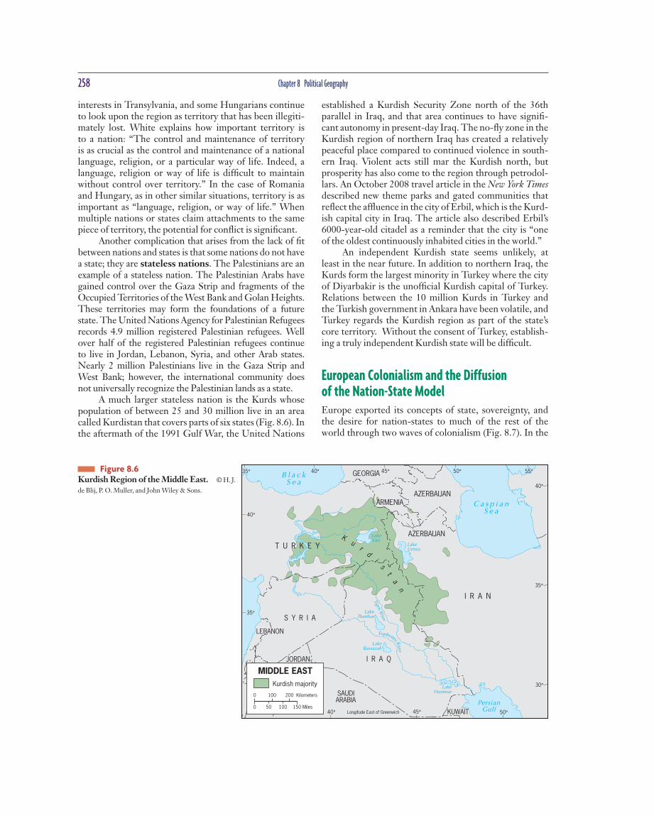
258 Chapter 8 Political Geography
established a Kurdish Security Zone north of the 36th parallel in Iraq, and that area continues to have signifi -cant autonomy in present-day Iraq. The no-fl y zone in the Kurdish region of northern Iraq has created a relatively peaceful place compared to continued violence in south-ern Iraq. Violent acts still mar the Kurdish north, but prosperity has also come to the region through petrodol-lars. An October 2008 travel article in the New York Times described new theme parks and gated communities that refl ect the affl uence in the city of Erbil , which is the Kurd-ish capital city in Iraq. The article also described Erbil’s 6000-year-old citadel as a reminder that the city is “one of the oldest continuously inh a bited cities in the world.”
An independent Kurdish state seems unlikely, at least in the near future. In addition to northern Iraq, the Kurds form the largest minority in Turkey where the city of Diyarbakir is the unoffi cial Kurdish capital of Tu r key. Relations between the 10 million Kurds in Turkey and the Turkish government in Ankara have been vol a tile, and Turkey regards the Kurdish region as part of the state’s core territory. Without the consent of Turkey, establish-ing a truly independent Kurdish state will be di f fi cult.
European Colonialism and the Diffusion of the Nation-State Model Europe exported its concepts of state, sovereignty, and the desire for nation-states to much of the rest of the world through two waves of colonialism (Fig. 8.7). In the
interests in Transylv a nia, and some Hu n garians continue to look upon the region as territory that has been illegiti-mately lost. White explains how i m portant territory is to a nation: “The control and maintenance of territory is as crucial as the control and maint e nance of a national language, religion, or a particular way of life. Indeed, a la n guage, religion or way of life is diffi cult to maintain without control over territory.” In the case of Romania and Hungary, as in other similar situations, te r ritory is as important as “language, religion, or way of life.” When multiple nations or states claim a t tachments to the same piece of territory, the potential for confl ict is signifi cant.
Another complication that arises from the lack of fi t between nations and states is that some nations do not have a state; they are stateless nations. The Palestinians are an example of a stateless nation. The Palestinian Arabs have gained control over the Gaza Strip and fragments of the Occupied Territories of the West Bank and Golan Heights. These territories may form the foundations of a future state. The United Nations Agency for Palestinian Refugees records 4.9 million registered Palestinian refugees. Well over half of the registered Palestinian refugees conti n ue to live in Jordan, Lebanon, Syria, and other Arab states. Nearly 2 million Palestinians live in the Gaza Strip and West Bank; however, the international community does not universally recognize the Pale s tinian lands as a state.
A much larger stateless nation is the Kurds whose population of between 25 and 30 million live in an area called Kurdistan that covers parts of six states (Fig. 8.6). In the aftermath of the 1991 Gulf War, the United Nations
JORDAN
AZERBAIJAN
AZERBAIJAN
I R A Q
Longitude East of Greenwich
ARMENIA
I R A N
KUWAIT
GEORGIA
T U R K E Y
SAUDIARABIA
S Y R I A
LEBANON
Ku
rd
i
st
an
C a s p i a nS e a
B l a c kS e a
PersianGulf
LakeVan
LakeUrmia
LakeRassazah
LakeHammar
LakeTharthar
TigrisRiver
Euphrates River
40°
40°35° 45° 50°
50°45°40°
55°
35°
40°
35°
30°
MIDDLE EAST
0 100 200 Kilometers
0 50 100 150 Miles
Kurdish majority
Figure 8.6 Kurdish Region of the Middle East. © H. J.
de Blij , P. O. Muller, and John W i ley & Sons.

How Is Space Politically Organized Into States and Nations? 259
the fl ows of raw materials for their own benefi t, and we can still see the tangible evidence of that organization (plantations, ports, mines, and railroads) on the cultural landscape.
Despite the end of colonialism, the political organi-zation of space and the global world economy persist. And while the former colonies are now independent states, their economies are anything but indepen d ent. In many cases raw material fl ows are as great as they were before the colonial era came to an end. For example, today in Gabon, Africa, the railroad goes from the interior forest, which is logged for plywood, to the major port and capi-tal city, Libreville. The second largest city, Port Gentil , is located to the south of Libreville, but the two cities are not connected directly by road or railroad. As the crow fl ies, the cities are 90 miles apart, but if you drive from one to the other, the circuitous route will take you 435 miles. Both cities are export focused. Port Gentil is tied to the global oil economy, with global oil corporations respon-sible for building much of the city and its housing, and employing many of its people.
Construction of the Capitalist World Economy The long-term impacts of colonialism are many and var-ied. One of the most powerful impacts of colonialism was the construction of a global order characterized by great differences in economic and political power. The European colonial enterprise gave birth to a globalized economic order in which the European states and areas dominated by European migrants emerged as the major centers of economic and political activity. Through
sixteenth century, Spain and Portugal took advantage of an increasingly well-consolidated internal political order and newfound wealth to expand their infl u ence to increas-ingly far-fl ung realms during the fi rst wave of colonial-ism. Later joined by Britain, France, the Netherlands, and Belgium, the fi rst wave of colonialism established a far-reaching political and economic system. A f ter indepen-dence movements in the Americas during the late 1700s and 1800s, a second wave of c o lonialism began in the late 1800s. The major colonizers were Britain, France, the Netherlands, Belgium, Germany, and Italy. The coloniz-ing parties met for the Berlin Conference in 1884–1885 and arb i trarily laid out the colonial map of Africa with-out reference to indigenous cultural or political arrange-ments. Driven by motives ranging from economic profi t to the desire to bring Christianity to the rest of the world, colonialism projected European power and a European approach to organizing poli t ical space into the non-Euro-pean world (Fig. 8.8).
With Europe in control of so much of the world, Europeans laid the ground rules for the emerging inter-national state system, and the modern European concept of the nation-state became the model adopted around the world. Europe also established and defi ned the ground rules of the capitalist world economy, creating a sy s tem of economic interdependence that persists today.
During the heyday of colonialism, the imperial pow-ers exercised ruthless control over their domains and organized them for maximum economic exploitation. The capacity to install the infrastructure necessary for such effi cient profi teering is itself evidence of the power rela-tionships involved: entire populations were regimented in the service of the colonial ruler. Colonizers organized
Figure 8.7 Two Waves of Colonialism between 1500 and 1975. Each bar shows the total number of colonies around the world. Adapted with permission from: Peter J. Taylor and Colin
Flint, Political Geogr a phy: World-Economy, Nation-State
and Locality, 4th ed., New York: Prentice Hall, 2000.

260 Chapter 8 Political Geography
other parts of East and Southeast Asia as well as Pacifi c Islands by colonial means. But the concentr a tion of wealth that colonia l ism brought to Europe, and to parts of the world dominated by European settlers, i n cluding the United States, Canada, and Australia, is at the heart of the highly uneven global distribution of power that continues even t o day.
The forces of colonialism played a key role in knit-ting together the economies of widely separated a r eas, which gave birth to a global economic order called the world economy. Wealth is unevenly distributed in the world economy, as can be seen in statistics on per cap-ita gross national income (GNI): Bangladesh’s GNI is only $1,340, whereas Norway’s is $53,690. But to truly
colonialism, Europeans extracted wealth from colonies and put colonized peoples in a p o sition of subservience.
Of course, not all Europeans profi ted equally from colonialism. Enormous poverty persisted within the most powerful European states, and sustaining control over colonies could be costly. In the late seventeenth century, Spain had a large colonial empire, but the empire was economically draining Spain by then. Moreover, west-ern Europeans were not the only people to profi t from colonialism. During the period of European colonia l ism (1500–1950), Russia and the United States expanded over land instead of over seas, profi ting from the taking of ter-r i tory and the subjugation of indigenous peoples. Japan was a regional colonial power, controlling Korea and
Figure 8.8 Dominant Colonial Infl uences, 1550–1950. The map shows the dominant European or Japanese colonial infl uence in each country over the four centuries. © H. J. de Blij , John W i ley & Sons.
P A C I F I C
O C E A N
A T L A N T I C
O C E A N
SOUTHERNOCEAN
Tropic of Cancer
Equator
Tropic of Capricorn
60°
40°40°
20°20°20°
0°
20° 20° 20°
40°
60°
40°
60°
40°
60°
40°
60°160° 140° 120° 80° 60° 40°
CANADA
UN I TED STATESOF AMER ICA
U.S.(Alaska)
GREENLAND
MEXICO
BERMUDA
GUATEMALA
BELIZE
EL SALVADOR
HONDURAS
NICARAGUA
COSTA RICAPANAMA
JAMAICA
BAHAMAS
CUBA
HAITI
DOMINICANREPUBLIC
PUERTORICO
BARBADOS
TRINIDAD & TOBAGO VENEZUELA
COLOMBIA
ECUADOR
PERU
BOLIVIA
BRAZIL
FRENCH GUIANA SURINAME
GUYANA
PARAGUAY
URUGUAY
ARGENTINA
CHILE
U.S.(Hawaii)DOMINANT COLONIAL INFLUENCES
OVER FOUR CENTURIES, 1550–1950(including mandates)
Great Britain
France
Spain
Portugal
Netherlands
Belgium
Italy
Turkey
Russia
Japan
Denmark
Not colonized by Europe or Japan
0
0 20001000 3000 Kilometers
1000 2000 Miles
How Is Space Politically Organized Into States and Nations? 261
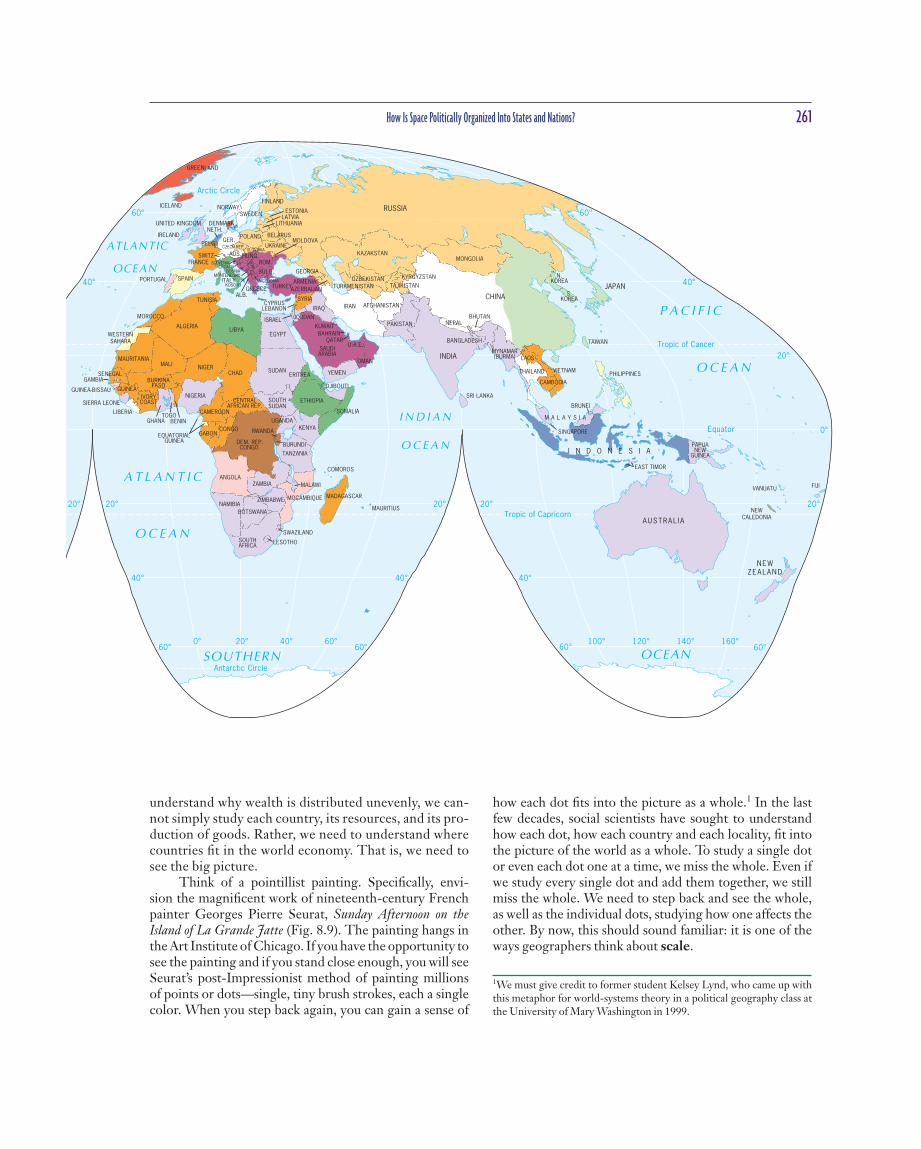
how each dot fi ts into the pi c ture as a whole.1 In the last few decades, social scientists have sought to understand how each dot, how each country and each locality, fi t into the picture of the world as a whole. To study a single dot or even each dot one at a time, we miss the whole. Even if we study every single dot and add them together, we still miss the whole. We need to step back and see the whole, as well as the individual dots, studying how one affects the other. By now, this should sound familiar: it is one of the ways geographers think about scale.
understand why wealth is distributed unevenly, we can-not simply study each country, its resources, and its pro-duction of goods. Rather, we need to understand where countries fi t in the world economy. That is, we need to see the big picture.
Think of a pointillist painting. Specifi cally, envi-sion the magnifi cent work of nineteenth-century French painter Georges Pierre Seurat , Sunday Afternoon on the Island of La Grande Jatte (Fig. 8.9). The painting hangs in the Art Institute of Chicago. If you have the opportunity to see the painting and if you stand close enough, you will see Seurat’s post-Impressionist method of painting millions of points or dots—single, tiny brush strokes, each a single color. When you step back again, you can gain a sense of
ATLANTIC
OCEAN
A T L A N T I C
O C E A N
I N D I A N
O C E A N
O C E A N
P A C I F I C
SOUTHERN OCEAN
Tropic of Cancer
Tropic of Capricorn
Arctic Circle
Equator
Antarctic Circle
60° 60°
40°40°
20°
0°
20° 20° 20° 20° 20°
40°
60°
40°
60°
40°
60° 60°0° 20° 40° 60° 100° 120° 140° 160°
MACEDONIA
SLOVENIACROATIA
BOSNIAMONTENEGRO
KOSOVO
SERB.
CZECH REP.SLOVAKIA
GREENLAND
ICELAND
IRELAND
UNITED KINGDOM
PORTUGAL SPAIN
FRANCE
BELG.
NETH.
GER.POLAND
ITALY
SWITZ. AUS.ROM.
BULG.
ALB.GREECE TURKEY
CYPRUS
HUNG.
NORWAYSWEDEN
FINLAND
DENMARK
ESTONIA
LITHUANIA
LEBANONMOROCCO
ALGERIALIBYA
TUNISIA
EGYPT
SUDAN
SOUTHSUDAN
CHADNIGERMALI
MAURITANIA
ETHIOPIA
DJIBOUTI
SOMALIA
SENEGALGAMBIA
GUINEA-BISSAU GUINEA
SIERRA LEONE
LIBERIA
GHANA
IVORYCOAST
TOGOBENIN
NIGERIA
CAMEROON
BURKINAFASO
CENTRALAFRICAN REP.
DEM. REP.CONGO
CONGOGABONEQUATORIAL
GUINEA
UGANDAKENYA
TANZANIA
RWANDA
BURUNDI
ANGOLAZAMBIA MALAWI
MOÇAMBIQUEZIMBABWE
BOTSWANANAMIBIA
SOUTHAFRICA LESOTHO
SWAZILAND
MADAGASCAR
MAURITIUS
COMOROS
LATVIA
BELARUS
UKRAINEMOLDOVA
RUSSIA
GEORGIA
ARMENIAAZERBAIJAN TURKMENISTAN
UZBEKISTAN
KAZAKSTAN
KYRGYZSTAN
TAJIKISTAN
MONGOLIA
IRAN
CHINA
IRAQ
SYRIA
JORDANISRAELKUWAIT
SAUDIARABIA
QATARBAHRAIN
U.A.E.
OMAN
YEMEN
AFGHANISTAN
PAKISTAN
INDIA
NEPAL
SRI LANKA
BHUTAN
BANGLADESH
MYNAMAR(BURMA)
THAILAND
CAMBODIA
LAOS
VIETNAM
TAIWAN
PHILIPPINES
I N D O N E S I APAPUANEW
GUINEA
AUSTRAL I A
NEWZEALAND
JAPAN
N.KOREA
S.KOREA
NEWCALEDONIA
VANUATU FIJI
SINGAPORE
M A L A Y S I A
ERITREA
WESTERNSAHARA
BRUNEI
EAST TIMOR
1We must give credit to former student Kelsey Lynd, who came up with this metaphor for world-systems theory in a political geography class at the University of Mary Washington in 1999.

262 Chapter 8 Political Geography
producers gain profi t by commodifying whatever they can. Commodifi cation is the process of pla c ing a price on a good, ser v ice, or idea and then buying, selling, and trading that item. Companies create new products, gen-erate new twists on old products, and create demand for the products through marketing. As chil d ren, none of the authors of this book could have imagined buying a bottle of water. Now, the sale of water in bottles is commo n place.
Second, despite the existence of approximately 200 states, everything takes place within the context of the world economy (and has since 1900). Colonialism played a major role in establishing this system by exporting the European state idea and facilita t ing the construction of an interdependent global economy. When col o nies became independent, gaining the legal status of sovereign states was relatively easy for most colonies. The United Nations Charter even set up a committee to help colonies do so after World War II. But gaining true econo m ic indepen-dence is all but impossible. The economies of the world are tied together, generating intended and unintended consequences that fundame n tally change places.
Lastly, world-systems theorists see the world econ-omy as a three-tiered structure: the core, periphery, and semiperiphery . The core and the periphery are not just places but the sites where particular pro c esses take place. The core is where one is most likely to fi nd higher levels of education, higher salaries, and more techno l ogy—core processes that generate more wealth in the world econ-omy. The periphery more commonly has lower levels of education, lower salaries, and less technology—peripheral processes associated with a more marginal position in the world eco n omy.
Political geographers took note of one sociologist’s theory of the world economy and added much to it. Build-ing on the work of Immanuel Wallerstein , proponents of world-systems theory view the world as much more than the sum total of the world’s states. Much like a pointillist painting, world-systems theorists hold that to understand any state, we must also understand its spatial and func-tional relationships within the world eco n omy.
Wallerstein’s publications number in the hundreds, and the political and economic geography publications tied to world-systems theory number in the thousands. To simplify the research, we can study the three basic tenets of world-systems theory, as Wallerstein defi nes them:
1. The world economy has one market and a global division of labor.
2. Although the world has multiple states, almost every-thing takes place within the context of the world economy.
3. The world economy has a three-tier structure.
According to Wallerstein , the development of a world economy began with capitalist exchange around 1450 and encompassed the globe by 1900. Capitalism means that in the world economy, individuals, corpora-tions, and states produce goods and services that are exchanged for profi t. To generate a profi t, produ c ers seek the cheapest production and costs. Since labor (including salaries and benefi ts) is now often the most e x pensive of these production costs, corporations often seek to move production of a good from, for example, North Carolina to Mexico and then to China, simply to take advantage of cheaper labor. In addition to the world labor supply,
Figure 8.9 Chicago, Illinois. Sunday After-noon on the Island of La Grande Jatte by Georges Pierre Seurat hangs in the Art Institute of Chicago. © Bridgeman Art Library/
SUPERSTOCK.

How Is Space Politically Organized Into States and Nations? 263
fee, fruit, and cotton production. During the second wave of colonialism, which happened after the Indu s trial Revo-lution, colonizers set their sights on cheap industrial labor, cheap raw materials, and large-scale agricu l tural plantations.
Not all core countries in the world today were colo-nial powers, however. Countries including Switzerland, Singapore, and Australia have signifi cant global clout even though they were never classic colonial po w ers, and that clout is tied in signifi cant part to their positions in the global economy. The countries gained positions through access to the networks of production, consumption, and exchange in the wea l thiest parts of the world and through their ability to take advantage of that access.
World-Systems and Political Power Are economic power and political power one and the same? No, but certainly economic power can bring polit i- cal power. In the current system, economic power means wealth, and political power means the ability to infl u ence others to achieve your goals. Political power is not simply a function of sovereignty. Each state is theoret i cally sover-eign, but not all states have the same ability to infl uence others or achieve their political goals. Ha v ing wealth helps leaders amass political power. For instance, a wealthy
Figure 8.10 presents one way of dividing up the world in world-systems terms. The map desi g nates some states as part of the semiperiphery —places where core and periphery processes are both occu r ring—places that are exploited by the core but in turn exploit the periphery. The semiperiphery acts as a buffer between the core and periphery, preventing the polarization of the world into two e x tremes.
Political geographers, economic geographers, and other academics continue to debate world-systems theory. The major concerns are that it overemphasizes economic factors in political development, that it is very state-centric, and that it does not fully account for how places move from one category to another. Nonetheless, Wallerstein’s work has encouraged many to see the world political map as a system of interlinking parts that need to be under-stood in relation to one another and as a whole. As such, the impact of world-systems theory has been considerable in political geography, and it is increasingly commonplace for geographers to refer to the kinds of core–periphery distin c tions suggested by world-systems theory.
World-systems theory helps explain how colonial powers were able to amass great concentrations of wealth. During the fi rst wave of colonialism, colonizers extracted goods from the Americas and the Caribbean and exploited Africa for slave labor, amassing wealth through sugar, cof-
P A C I F I C
O C E A N
AT L A N T I C
O C E A N
A R C T I C O C E A N
I N D I A N
O C E A N
P A C I F I C
O C E A N
THE WORLD-ECONOMY
Core
Semi-periphery
Periphery
Disputed dependingon criteria used
0 2000 Kilometers
0 2000 Miles
Figure 8.10 The World Economy. One representation of core, per i phery, and semi-periphery based on a calculation called World-Economy Centrality, derived by sociologist Paul Prew . The authors took into consideration factors not quantifi ed in Prew’s data, including membership in the European Union, in moving some countries from the categories Prew’s data recommended to other categories. Data from: Paul Prew , World-Economy Centrality and Carbon Dioxide Emissions: A New Look at the
Position in the Capitalist World-System and Environmental Pollution, American Sociological Association, 12, 2 (2010) 162–191.

264 Chapter 8 Political Geography
HOW DO STATES SPATIALLY ORGANIZE THEIR GOVERNMENTS? In the 1950s, a famous political geographer, R i chard
Hartshorne, described the forces within the state that unify the people as centripetal and the forces that divide them as centrifugal. Whether a state continues to exist, according to Hartshorne, depends on the balance between centripetal and centrifugal forces. Many political geo g ra-phers have debated Hartshorne’s theory, and most have concluded that we cannot select a given event or process and simply defi ne it as centrifugal or centripetal. An event such as a war can pull the state together for a short time and then divide the state over the long term. Timing, scale, interaction, and pe r spe c tive factor into unifi cation and division in a state at any given point. Instead of creat-ing a balance sheet of centripetal and ce n trifugal forces, governments attempt to unify states through nation-building, through structuring the go v ernment in a way that melds the nations within, by defi ning and defending boundaries, and through expres s ing control over all of the territory within those boundaries.
By looking at how different governments have attempted to unify the peoples and territories within their domains, we are reminded how important geography is. Governance does not take place in a vacuum. The unique characteristics of places shapes whether any possible gov-ernmental “solution” solves or exacerbates ma t ters.
Form of Government The internal political geographic organization of states can have an impact on state unity. Most states in the world are either unit a ry or federal states.
Until the end of World War II, many European states, including multinational states, were highly central-ized, with the capital city serving as the focus of power. States made no clear e f forts to accommodate minor i ties (such as Bretons in France or Basques in Spain) or outly-ing regions where identifi cation with the state was weaker. Political geographers call these highly centralized states unitary governments. The administrative framework of a unitary government is designed to ensure the central government’s authority over all parts of the state. The French government divided the state into more than 90 départements , whose representatives came to Paris not just to express regional concerns but to implement central-government decisions back home.
One way of governing a multinational state is to construct a federal system, organizing state territory into regions, substates (which we refer to as States), provinces, or cantons. In a strong federal system, the regions have much control over government policies and funds, and
country can establish a mighty military. But political infl u-ence is not simply a function of hard power; it is also dip-lomatic. Switzerland’s declared neutral i ty, combined with its economic might, aids the country’s diplomatic efforts.
World-systems theory helps us understand how Europe politically reorganized the world during colon i al-ism. When colonialism ended in Africa and Asia, the newly independent people continued to follow the European model of political organization. The arbitrarily drawn colonial borders of Africa, dating from the Berlin Con-ference, b e came the boundaries of the newly independent states. On the map, former colonies became new states; administrative borders transformed into international boundaries; and, in most cases, colonial administrative towns b e came capitals. The greatest political challenge fa c ing the states of Africa since independence has been building nation-states out of incredibly divergent (some-times antagonistic) peoples. The leaders of the newly indepen d ent states continually work to build nation-states in the hope of quelling division among the people, secur-ing their territory, and developing their economic (as well as other) sy s tems of organization.
The Enduring Impact of the Nation-State Idea The idea of meshing the nation and state into a n a tion-state was not confi ned to nineteenth-century Europe or twentieth-century Africa. Major players in international relations still seek solutions to complex political co n- fl icts by trying to redraw the political map in an effort to bring political and national borders into closer corre-spondence. Faced with the disintegration of the former Yugoslavia or the complex problems of Israel/Palestine, for example, the tendency is often to propose new state boundaries around nations, with the goal of making the nation and state fi t. Drawing neat boundaries of this sort is usually impossible and the creation of new territories can create different ethno-national problems. Regard-less of the multitude of problems and lack of simple sol u tions to nation and state confl icts, the European territorial state idea became the world model, and that idea is still shaping the political organiz a tion of space around the world.
Imagine you are the leader of a newly independent state in Africa or Asia. Determine what your government can do to build a nation that corresponds with the borders of your state. Consider the roles of education, government, military, and culture in your exercise in n a tion-building.
How Do States Spatially Organize Their Governments? 265
of the Soviet Union, Yugoslavia, and Czechoslovakia fell apart, despite their federalist systems, and the future of Belgium as a single state is uncertain.
Devolution Devolution is the movement of power from the central government to regional governments within the state. Sometimes devolution is achieved by reworking a con-stitution to establish a federal system that recogni z es the permanency of the regional governments, as Spain has done. In other places, governments devolve power wit h- out altering constitutions, almost as an experiment. In the United Kingdom, the Northern Ireland Assembly, a par-liamentary body, resulted from devolution, but the Brit-ish government suspended its activities in 2002 and then reinstated the assembly in 2007. Devolutionary forces can emerge in all kinds of states, old and young, large and small. These forces arise from several sources of internal division: ethnocultural , ec o nomic, and territorial.
Ethnocultural Devolutionary Movements Many of Europe’s devolutionary movements came from nations within a state that defi ne themselves as being eth-nically, linguist i cally, or religiously distinct.
The capacity of ethnocultural forces to stimulate devolutionary processes has been evident, for example, in eastern Europe. Parts of the eastern European map have changed quite drastically over the past two de c ades, and two countries, Czechoslovakia and Yugoslavia, succumbed to devolutionary pressures. In the case of Cz e choslovakia, the process was peaceful: Czechs and Slovaks divided their country, creating a new international border. As Figure 8.13 shows, however, one of the two new states,
in a weak federal system, the central government retains a signifi cant measure of power. Most federal systems are somewhere in between, with gover n ments at the state scale and at the substate scale each having control over certain revenues and ce r tain policy areas. Gi v ing control over certain policies (e s pecially culturally relative policies) to smaller-scale governments is one strategy for keeping the state as a whole together.
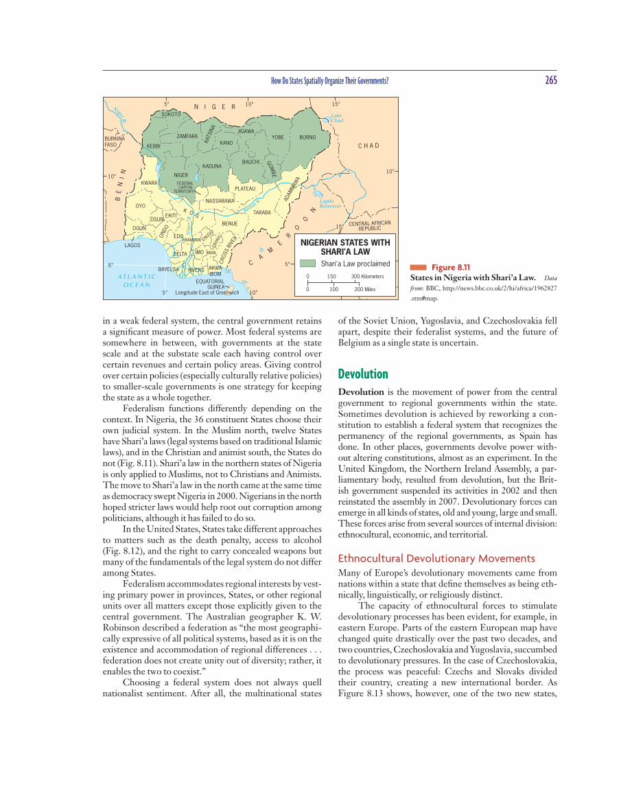
Federalism functions differently depending on the context. In Nigeria, the 36 constituent States choose their own judicial system. In the Muslim north, twelve States have Shari’a laws (legal systems based on traditional Islamic laws), and in the Christian and animist south, the States do not (Fig. 8.11). Shari’a law in the northern states of Nigeria is only applied to Muslims, not to Christians and Animists. The move to Shari’a law in the north came at the same time as democracy swept Nigeria in 2000. Nigerians in the north hoped stri c ter laws would help root out corruption among politicians, although it has failed to do so.
In the United States, States take different approaches to matters such as the death penalty, access to alcohol (Fig. 8.12), and the right to carry concealed weapons but many of the fundamentals of the legal system do not differ among States.
Federalism accommodates regional interests by vest-ing primary power in provinces, States, or other regional units over all matters except those explicitly given to the central government. The Australian geographer K. W. Robinson described a federation as “the most geographi-cally expressive of all political systems, based as it is on the existence and accommodation of regional differences . . . federation does not create unity out of d i versity; rather, it enables the two to coexist.”
Choosing a federal system does not always quell nationalist sentiment. After all, the multinational states
5° 10° 15°
15°
10°
10°
5°
5°
5°
10°
15°
Longitude East of Greenwich
SOKOTO
KEBBIKANO
JIGAWAYOBE BORNO
TARABA
BAUCHIKADUNA
NIGER
KWARAPLATEAU
NASSARAWA
BENUE
EKITI
OYO
OGUN
LAGOS
BAYELSA RIVERS
IMO ABIA
AKWAIBOM
EDOANAMBRA
ADAM
MAW
A
KATS
INA
ON
DO
FEDERALCAPITAL
TERRITORY
OSUNEB
ONYI
ENUGU
ZAMFARA
CRO
SS R
IVER
K O GI
DELTA
GOM
BE
N I G E R
EQUATORIALGUINEA
BE
NI
N
BURKINAFASO C H A D
CA
ME
RO
ON
CENTRAL AFRICANREPUBLIC
A T L A N T I C
O C E A N
LakeChad
Benue R. Lagdo
Reservoir
MbakaouReservoir
Niger R.
Nig
er
R.
Shari'a Law proclaimed
NIGERIAN STATES WITHSHARI'A LAW
0
200 Miles0
300 Kilometers150
100
Figure 8.11 States in Nigeria with Shari’a Law. Data
from: BBC, http://news.bbc.co.uk/2/hi/africa/1962827
.stm#map.

succes s fully, integrated 56 ethnic nations into the state of China. China has acknowledged the precarious place of the minor i ty nations within the larger Han-domi-nated state by extending rights to minorities, including the right to have two children under the government’s One Child Policy. Whether the nations within China will cha l lenge the state remains to be seen. In China’s far west, Tibetan and U y ghur separ a tist movements have become more visible, but the Chinese government’s fi rm hold and control of the media and Internet makes it diffi cult, if not i m possible, for separatist groups to hold Egyptian-style protests in China.
Devolution, however, does not necessarily fuel greater calls for independence. Nations within states can, instead, call for autonomy within the borders of the state. In the United Kingdom, Scotland voted in 1997 to establish its own parliament, which had last met in 1707. The 129 members of the Scottish Parliament swear all e giance to the Queen of England. The Scottish Parliament has the right to introduce primary legislation over several issues, including education, health, housing, and police. Unlike the parliament in Wales that was esta b lished in 1997 and
Slovakia, is not homogeneous. About 11 percent of Slovakians are Hungarian, and that minority is concen-trated along the border between Slovakia and Hungary. The Hungarian minority, concerned about linguistic and cultural discrimination, has at times demanded greater autonomy or self-governance to protect its heri t age in the new state of Slovakia.
Compared to the constituent units of the former Yugoslavia (discussed in detail in Chapter 7), other coun-tries shown in Figure 8.14 have dealt with devolutionary pressures more peacefully. Among these are Lithuania and Ukraine. Elsewhere in the world, ho w ever, ethno-cultural fragmentation has produced costly wars. For example, ethno-cultural differences were at the heart of the civil war that wracked Sri Lanka (South Asia) between the 1980s and 2009, with the Sinhalese (Buddhist) major-ity ultimately suppressing the drive by the Tamil (Hindu) minority for an independent state.
Devolutionary forces based on ethno-cultural claims are gaining momentum in places that have long looked stable from the outside. The communist govern-ment of China has pragmatically, and arguably relatively
Guest Field Note Interstate-40, near Blackwell, Arkansas.
In most states in the U.S., a “dry county” might cause one to think of a place where there is very li t tle rain. But in the southern part of the U.S., there are many dry counties—that is, counties with laws forbidding the sale of packaged alcohol. In the late 1800s and early 1900s, keep-ing counties dry was much easier than it is t o day. A hundred years ago, it took up to a day to travel to the next town or city on very poor roads. Today, with cars traveling 70 MPH on an interstate, the same trip takes a matter of minutes. Why would counties continue to ban a l cohol sales today? Many of the rea-sons are cultural. Of the Arkansas resi-dents who attend church, most are Bap-tists (see Figure 7.28) or other Protestant denominations. Many of these churches prohibit consumption of alcoholic beverages. The Arkansas legislature supports dry counties by requiring counties that want to sell packaged li q uor to get 38 percent of the voters in the last election to sign a petition. It only takes 10 percent of that voter pool to get any other issue on the ballot. Today, however, many dry counties in A r kansas are known as “damp.” Damp counties are those where restaurants, country clubs and social organiza-tions can apply and receive a l i cense to serve alcohol by the drink. This arrangement seems counterintuitive to the idea of a dry county. But business and economic development authorities want damp counties to e n courage investment and growth in the local economy.
Credit: Paul T. Gray, Jr., Russellville High School
Figure 8.12
266

How Do States Spatially Organize Their Governments? 267
by the government in Rome high on the list of griev-ances. Italy also faces serious devolutionary forces on its mainland peninsula. One is rooted in regional dis-parities between north and south. The Mezzogiorno region lies to the south, below the Ancona Line (an imaginary border extending from Rome to the Adriatic coast at Ancona ). The wealthier north stands in sharp contrast to the poorer south. Despite the large subsi-dies granted to the Me z zo g iorno , the development gap between the north, very much a part of the European core, and the south, part of the European periphery, has been widening. Some Italian politicians have exploited widespread impatience with the situation by forming organizations to promote northern interests, including devolution. One of these organiz a tions, the Northern League, has raised the prospect of an independent state called Padania in the northern part of Italy centered on the Po River. After a surge of enthusiasm, the Padania campaign faltered, but it pushed the Italian government to focus more attention on regional inequalities within the country.
Brazil provides another example of the interconnec-tions between devolutionary movements and economics. As in northern Italy, a separatist movement emerged in the 1990s in a better-off region in the south that includes the three southernmost States of Rio Grande do Sul ,
the assembly in Northern Ireland that was established in 1998, the parliament of Scotland has the right to levy a tax of up to 3 pence per British pound.
Devolutionary pressures can create demands for new states, such as the Czech Republic and Slovakia, or for greater autonomy within a state, like Scotland in the United Kingdom.
Economic Devolutionary Forces Devolutionary pressures often arise from a combination of sources. In Catalonia, ethnocultural differences play a signifi cant role, but Catalonians also cite economics; with about 6 percent of Spain’s territory and just 15 percent of its population, Catalonia produces some 25 percent of all Spanish exports by value and 40 percent of its industrial exports (Fig. 8.15). Pro-independence groups in Cata-lonia held a referendum in April 2011 seeking a vote for independence. The vote failed, but devolutionary forces continue to argue that Cat a lonia’s economy pays more into the Spanish government than it receives from the state of Spain.
Economic forces play an even more prominent role in Italy and France. In Italy, demands for auton-omy for Sardinia are deeply rooted in the island’s eco-nomic circumstances, with accusations of neglect
B l a c k S e a
Sea of
Azov
Aegean Sea
Adr ia t ic Sea
Baltic
Se
a
BOSNIA
ALBANIA
KOSOVOCROATIA
RUSSIA
BELARUS
LATVIA
LITHUANIA
POLAND
SWEDEN
GERMANY
CZECH REPUBLIC
SLOVAKIA
AUSTRIA
HUNGARY
SLOVENIA
CROATIA ROMANIA
ITALY
GREECE
UKRAINE
MOLDOVA
ESTONIA
BULGARIA
TURKEY
RUSSIA
MACEDONIA
SERBIA
MONTENEGRO
DENMARK
ITALY
45°
50°
15° 20° 25°
30°
25°15° 20°
40°
45°
55°
50°
35°
10° 30° 35°
Longitude East of Greenwich
40°
ETHNIC MOSAIC OFEUROPE’S EASTERN FLANK
0 100 200 300 Kilometers
500 100 150 Miles
After Hoffman, 1953
Slavic
Czechs
Slovaks
Slovenes
Croats
Muslims
Bulgars
Macedonians
Serbs
Ukrainians
No groupover 50%
Non-Slavic
Russians
Turks
Magyars
Albanians
Romanians
Belarussians
Poles
Pomaks
Latvians
Lithuanians
Montenegrins
Figure 8.13 Ethnic Mosaic of Eastern Europe. © Adapted (in part) with permission from George
Hoffma ed., Europe in the 1990s: A Geographical
Analysis , 6th rev. ed., p. 551.
268 Chapter 8 Political Geography
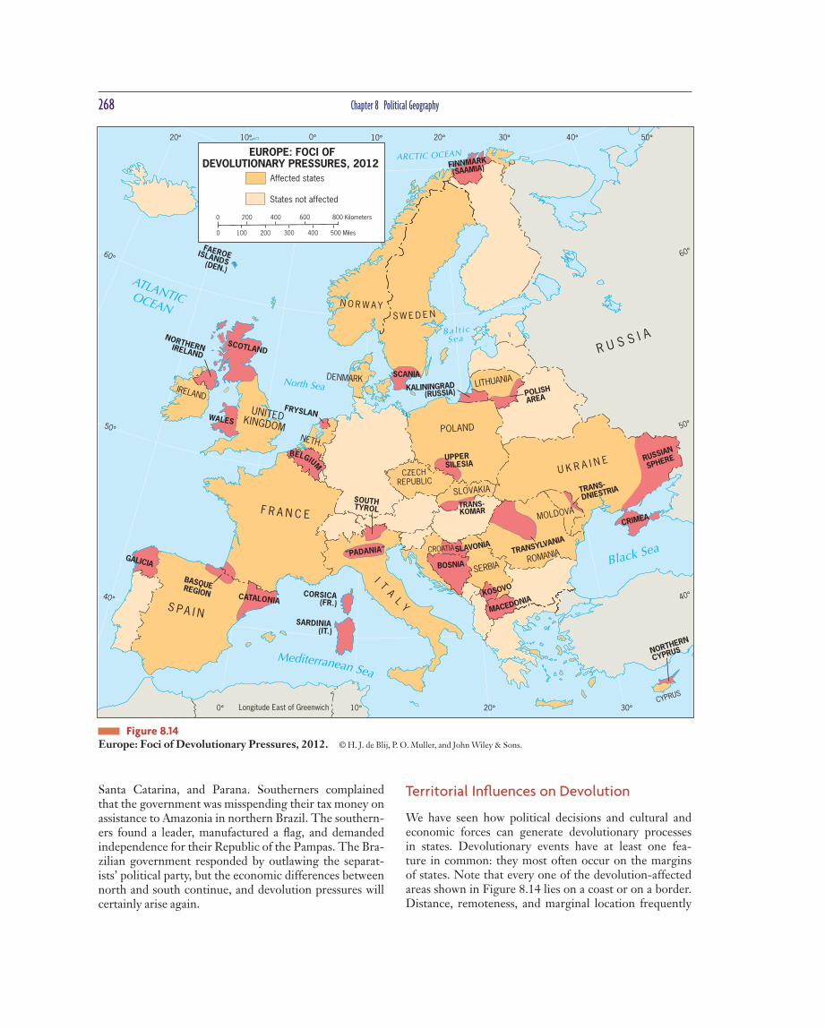
Territorial Infl uences on Devolution
We have seen how political decisions and cultural and economic forces can generate devolutionary processes in states. Devolutionary events have at least one fea-ture in common: they most often occur on the ma r gins of states. Note that every one of the devolution-affected areas shown in Figure 8.14 lies on a coast or on a border. Distance, remoteness, and marginal location frequently
Santa Catarina , and Parana . Southerners complained that the government was misspending their tax money on assistance to Amazonia in northern Br a zil. The southern-ers found a leader, manufactured a fl ag, and demanded independence for their Republic of the Pampas. The Bra-zilian government responded by outlawing the separat-ists’ political party, but the economic differences b e tween north and south continue, and devolution pressures will certainly arise again.
BASQUEREGION
LITHUANIA
CRIMEA
I TA
LY
IRELAND
UNITED KINGDOM
F R A N C E
S P A I N
CATALONIA
BELGIUM
SOUTH TYROL
CZECH REPUBLIC
CROATIA
SLOVAKIA
MACEDONIA
U K R A I N E
MOLDOVA
POLISH
AREA KALININGRAD
(RUSSIA)
R U S S I A SCOTLAND
BOSNIA
SLAVONIA
TRANS- KOMAR
WALES
"PADANIA"
SCANIA
FINNMARK
(SAAMIA)
KOSOVO
UPPER SILESIA
POLAND
NORTHERN IRELAND
FRYSLAN
SERBIA GALICIA
NETH.
CORSICA (FR.)
SARDINIA (IT.)
DENMARK
S W E D E N N O R W A Y
RUSSIAN
SPHERE
DNIESTRIA TRANS-
TRANSYLVANIA
ROMANIA
FAEROE (DEN.)
ISLANDS
NORTHERN
CYPRUS
CYPRUS
40°
50°
60°
40°
50°
60°
20°10°0°10°20° 30° 50°40°
0° 10° 20° 30°Longitude East of Greenwich
Mediterranean Sea
ATLANTIC OCEAN
Black Sea
North Sea
ARCTIC OCEAN
B a l t i cS e a
EUROPE: FOCI OFDEVOLUTIONARY PRESSURES, 2012
0
200 300 400 500 Miles
800 Kilometers600400200
1000
Affected states
States not affected
Figure 8.14 Europe: Foci of Devolutionary Pressures, 2012. © H. J. de Blij , P. O. Muller, and John Wiley & Sons.

How Do States Spatially Organize Their Governments? 269
In that year, a vocal minority of native Hawai’ians and their sympathizers demanded the return of rights lost during the “occupation.” These demands included the right to reestablish an independent state called H a wai’i (before its annexation Hawai’i was a Polynesian king-dom) on several of the smaller islands. Their hope is that ultimately the island of Kauai, or at least a signifi cant part of that island, which is considered ancestral land, will become a component of the independent Hawai’ian state.
At present, the native Hawai’ian separatists do not have the numbers, resources, or infl uence to achieve their aims. The potential for some form of separation between Hawai’i and the mainland United States does exist, how-ever. The political geographer Saul Cohen theorized in 1991 that political entities situated in border zones between geopolitical powers may become gateway states, a b sorbing and assimilating diverse cultures and traditions and emerging as new entities, no longer dominated by one or the other. H a wai’i , he suggests, is a candidate for this status.
Territorial characteristics can play a signifi cant role in starting and sustaining devolutionary processes. Dis-tance can be compounded by differences in physical geog-raphy—a feeling of remoteness can be fueled by being iso-lated in a valley or separated by mountains or a river. Basic physical-geographic and locational fa c tors can thus be key ingredients in the devolutionary process.
Electoral Geography The partitioning of state territory into electoral districts represents another key component of a state’s internal political geography. Ele c toral geographers examine how the spatial confi guration of electoral districts and the vot-ing patterns that emerge in particular elections refl ect and infl uence social and political affairs. Various countries use different voting systems to elect their governments. For example, in the 1994 South African ele c tion, government leaders introduced a system of majority rule while award-ing some power to each of nine newly formed regions. The overall effect was to protect, to an extent, the rights of minor i ties in those regions.
In the 1994 election in South Africa, the leading political party, the African National Congress, designated at least 35 percent of its slate of candidates to women, helping South Africa become one of the world leaders in the percent of women who hold seats in parliament or legisl a ture (see Fig. 5.17).
The geographic study of voting behavior is espe-cially interesting because it helps us assess whether peo-ple’s voting tendencies are infl uenced by their geographic situation. Maps of voting patterns often produce surprises that can be explained by other maps, and Geographic Information Systems have raised this kind of analysis to
strengthen devolutionary tendencies. The regions most likely to seek dev o lution are those far from the national capital. Many are separated by water, desert, or mountains from the ce n ter of power and adjoin neighbors that may support separatist objectives.
Note also that many islands are subject to devolutionary processes: Corsica (France), Sardinia (Italy), Taiwan (China), Singapore (Malaysia), Zanzibar (Tanzania), Jolo (Philip-pines), Puerto Rico (United States), Mayotte (Comoros), and East Timor (Indonesia) are notable examples. As this list indi-cates, some of these islands became independent states, while others were divided during devolution. Insularity clearly has advantages for separatist movements.
Not surprisingly, the United States faces its most serious devolutionary pressures on the islands of Hawai’i (Fig. 8.16). The year 1993 marked the hundred-year anniversary of the United States’ annexation of Hawai’i ,
Figure 8.15 Barcelona, Spain. Barcelona’s long-standing economic and political signifi cance is indelibly imprinted in the urban land-scape. Once the heart of a far-fl ung Mediterranean empire, Barcelona went on to become a center of commerce and banking as the Iberian Peninsula industrialized. In the process, the city became a center of architectural innovation that is not just evi-dent in the major public buil d ings. The major streets are lined with impressive buildings—many with intricate stone façades. © A l exander B. Murphy.

270 Chapter 8 Political Geography
Pennsylvania, Ohio, and Michigan lost representatives and the Sun Belt States of Georgia, South Carolina, and Florida along with the southwestern States of Arizona, Nevada, and Utah gained re p resentatives.
In the United States, once reapportionment is complete, individual States go through the process of redistricting, each following its own system. The crite-ria involved in redistricting are numerous, but the most important is equal representation, achieved by ensuring that districts have approximately the same populations. In addition, the Supreme Court prefers compact and con-tiguous districts that keep political units (such as counties) intact. F i nally, the courts have repeatedly called for repre-sentational equality of racial and linguistic mino r ities.
Even after the civil rights movement of the 1950s and 1960s in the United States, minorities were refused voting rights in a mu l titude of districts and States around the country. County registrars would close their doors when African Americans came to register to vote, and intimidation kept many away from voting at the polls. Even in places where minorities were allowed to register and vote, the parties drawing the voting districts or choos-ing the electoral system would make it nearly impossible
new levels. Political geographers study church affi liation, income level, ethnic background, educ a tion attainment, and numerous other social and economic factors to gain an understanding of why voters in a ce r tain region might have voted the way they did.
The domain in which electoral geographers can have the most concrete infl uence is in the drawing of electoral districts. In a d e mocracy with representatives elected by dis-trict, spatial organization of the districts determines whose voice is heard in a given place—with impacts on who is elected. A voter’s most direct contact with government is at the local level. The United States Constitution establishes a system of territorial representation . In the Senate, each major territorial unit (State) gets two representatives, and in the House of Representatives, members are elected from territorially defi ned districts based on population.
The Co n stitution requires a census every ten years in order to enumerate the population and reapportion the representatives accordingly. Reapportionment is the process by which districts are moved accor d ing to popu-lation shifts, so that each district encompasses approxi-mately the same number of people. For example, after the 2010 census, several States in the Rust Belt, including
Field Note “As I drove along a main road through a Honolulu suburb I noticed that numerous houses had the Hawai’i State fl ag fl ying upside down. I knocked on the door of this house and asked the homeowner why he was trea t ing the State fl ag this way. He invited me in and we talked for more than an hour. ‘This is 1993,’ he said, ‘and we native Hawai’ians are letting the State government and the country know that we haven’t for-gotten the a n nexation by the United States of our kingdom. I don’t accept it, and we want our territory to plant our fl ag and keep the traditions alive. Why don’t you drive past the royal palace, and you’ll see that we mean it.’ He was right. The Iolani Palace, where the Hawai’ians ’ last monarch, Queen Liliuokalani , reigned until she was d e posed by a group of American busi-nessmen in 1893, was draped in black for all of Honolulu to see. Here was devoluti o n ary stress on American soil.”
Figure 8.16 Honolulu, Hawai’i . © H. J. de Blij .

How Do States Spatially Organize Their Governments? 271
minority populations with meandering co r ridors and fol-lowing Interstates to connect urban areas that have large minority populations (Fig. 8.18).
Strange-looking districts constructed to attain cer-tain political ends are nothing new in American politics. In 1812, Governor Elbridge Gerry of Massachusetts signed into law a district designed to give an adva n tage to his party—a district that looked so odd to artist Gilbert Stuart that he drew it with a head, wings, and claws. Stuart called it the “salamander district,” but a colleague immor-talized it by naming it a gerrymander (after the governor). Ever since, the term gerrymandering has been used to describe “redistricting for adva n tage.” Certainly, many of the districts now on the United States electoral map may be seen as gerr y manders, but for an important purpose: to provide representation to minorities who, without it, would not be represented as effe c tively in the House of Representatives. Despite this well-intended goal, others argue that the packing of minor i ties into majority-minority districts simply concentrates minority votes, creating a countrywide government that is less responsive to m i nor-ity concerns.
The larger point is that the spatial organization of voting districts is a fundamentally geographical phenom-enon, and it can have profound impacts on who is rep-resented and who is not—as well as peoples’ notions of fairness. And that is only the beginning. The voting pat-terns that emerge from particular elections can help rein-force a sense of regionalism and can shape a government’s
for the election of a minority to occur. For example, if a government has to draw ten districts in a State that is 60 percent white, 30 percent African Amer i can, and 10 per-cent Hispanic, it can easily dilute the minority voters by splitting them among multiple di s tricts, ensuring that the white population holds the majority in each district.
In 1982, the United States Congress amended the 1965 Voting Rights Act by outlawing districts that have the effect of weakening minority voting power. In a series of decisions, the courts interpreted this amendment to mean States needed to redistrict in a way that would ensure minority representation. Using this criterion in the redis-tricting that followed the 1990 census, States increased the number of majority-minority districts in the House of Representatives from 27 to 52. Majority-minority dis-tricts are packed districts in which a majo r ity of the pop-ulation is from the minority. In the hypothetical State described above, a redistricting follo w ing this criterion could have the goal of creating at least three majority-minority districts and a fourth where minorities had a siz-able enough population to infl uence the outcome of the election.
Ideally, majority-minority districts would be com-pact and contiguous and follow existing political units. Political geographers Jonathan Leib and Gerald Webster have researched the court cases that have resulted from trying to balance these often-confl icting criteria. To pack minorities who do not live compactly and contiguously, States have drawn bizarrely shaped districts, connecting
6
6
District11
District11
District10
District10
District9
District9
District5
District5
District5
District6
District6
District2
District2
District3
District 3
District13
District4
District4
District3
District3
3
District 3
3
3
6
3
District8
District8
9
District7
District7
ELECTORAL GEOGRAPHY
North Carolina: 1st CongressionalDistrict
North Carolina: 12th CongressionalDistrict
After 1990 Census
After 2000 Census
0
0 50
100 200 Kilometers
100 Miles
Figure 8.17 Electoral Geography. North Carolina’s congressional districts in 1992 and 2002. In 1992, North Carolina concentrated minori-ties into majority-minority districts. In 2002, North Car o lina made its districts more com-pact and defended them on criteria other than race, in accordance with Supreme Court deci-sions during the 1990s. Data from: United States
Census, 2011.
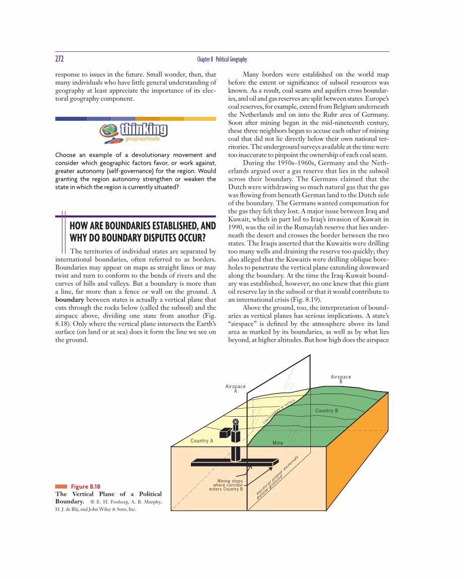
272 Chapter 8 Political Geography
Many borders were established on the world map before the extent or signifi cance of subsoil resources was known. As a result, coal seams and aquifers cross boundar-ies, and oil and gas r e serves are split b e tween states. Europe’s coal reserves, for example, extend from Belgium underneath the Net h erlands and on into the Ruhr area of Germany. Soon after mining began in the mid-nineteenth century, these three neighbors began to accuse each other of mining coal that did not lie directly below their own national ter-ritories. The underground surveys available at the time were too inaccurate to pinpoint the ownership of each coal seam.
During the 1950s–1960s, Germany and the Neth-erlands argued over a gas reserve that lies in the subsoil across their boundary. The Germans claimed that the Dutch were withdrawing so much natural gas that the gas was fl owing from beneath German land to the Dutch side of the boundary. The Germans wanted compensation for the gas they felt they lost. A major issue between Iraq and Kuwait, which in part led to Iraq’s i n vasion of Kuwait in 1990, was the oil in the Rumaylah reserve that lies under-neath the desert and crosses the border b e tween the two states. The Iraqis asserted that the Kuwaitis were drilling too many wells and draining the r e serve too quickly; they also alleged that the Kuwaitis were drilling oblique bore-holes to penetrate the vertical plane extending downward along the boundary. At the time the Iraq-Kuwait bound-ary was established, however, no one knew that this giant oil reserve lay in the subsoil or that it would contribute to an international crisis (Fig. 8.19).
Above the ground, too, the interpretation of bound-aries as vertical planes has serious implications. A state’s “airspace” is defi ned by the atmosphere above its land area as marked by its boundaries, as well as by what lies beyond, at higher altitudes. But how high does the airspace
response to issues in the future. Small wonder, then, that many individuals who have little general understanding of geography at least appreciate the impo r tance of its elec-toral geography component.
Choose an example of a devolutionary movement and consider which geographic factors favor, or work against, greater autonomy (self-governance) for the region. Would granting the region autonomy stren g then or weaken the state in which the region is currently situated?
HOW ARE BOUNDARIES ESTABLISHED, AND WHY DO BOUNDARY DISPUTES OCCUR? The territories of individual states are separated by
international boundaries, often referred to as borders. Bou n daries may appear on maps as straight lines or may twist and turn to conform to the bends of rivers and the curves of hills and va l leys. But a boundary is more than a line, far more than a fence or wall on the ground. A boundary between states is actually a vertical plane that cuts through the rocks below (called the subsoil) and the airspace above, dividing one state from another (Fig. 8.18). Only where the vertical plane inte r sects the Earth’s surface (on land or at sea) does it form the line we see on the ground.
Figure 8.18 The Vertical Plane of a Political Boundary. © E. H. Fouberg , A. B. Murphy,
H. J. de Blij , and John Wiley & Sons, Inc.

How Are Boundaries Established, and Why Do Boundary Disputes Occur? 273
Figure 8.19 The International Boundary between Iraq and Kuwait. Kuwait’s northern boundary was redefi ned and delimited by a United Nations boundary commission; it was demarcated by a series of concrete pil-lars 1.24 miles (2 kilometers) apart. © E. H.
Fouberg , A. B. Mu r phy, H. J. de Blij , and John Wiley &
Sons, Inc.
extend? Most states insist on controlling the airline traf-fi c over their territories, but states do not yet control the paths of satellite orbits.
Establishing Boundaries States typically defi ne the boundary in a treaty-like legal document in which actual points in the landscape or points of latitude and longitude are described. Cartog-raphers delimit the boundary by drawing on a map. If either or both of the states so desire, they can demar-cate the boundary by using steel posts, concrete pillars, fences, walls, or some other visible means to mark the boundary on the ground. By no means are all boundaries on the world map demarcated. Demarcating a lengthy boundary is expensive, and it is hardly worth the effort in high mountains, vast deserts, frigid polar lands, or other places with few permanent settlements. Demar-cating boundaries is part of state efforts to administrate borders—to determine how the boundaries will be mai n tained and to determine which goods and people may cross them. How a boundary is administered can change dr a matically over time, however (Fig. 8.20).
Types of Boundaries When boundaries are drawn using grid systems such as lat-itude and longitude or township and range, political geog-raphers refer to these boundaries as geometric boundar-ies. In North America, the United States and Ca n ada used a single line of latitude west of the Great Lakes to defi ne their boundary. During the Berlin Conference, colonial powers used arbitrary reference points and drew straight lines to establish the boundaries in much of Africa.
At different times, political geographers and other academics have advocated “natural” boundaries over geo-metric boundaries because they are visible on the landscape as physical geographic features. Physical-political (also called natural-political) boundaries are boundaries that follow an agreed-upon feature in the na t ural landscape, such as the center point of a river or the crest of a mountain range. The Rio Grande is an i m po r tant physical-political boundary between the United States and Mexico. Another physical-political boundary follows the crest lines of the Pyr-enees separating Spain and France. Lakes sometimes serve as boundaries as well; for example, four of the fi ve Great Lakes of North America are borders between the United States

274 Chapter 8 Political Geography
graphical circu m stances than with the character of the boundary itself.
Boundary Disputes The boundary we see as a line on a map is the product of a complex series of legal steps that begins with a wri t- ten description of the boundary. Sometimes that legal description is old and imprecise. Sometimes it was dic-tated by a stronger power that is now less dominant, giving the weaker neighbor a reason to a r gue for change. At other times the geography of the borderland has actu-ally changed; the river that marked the boundary may have changed course, or a portion of it has been cut off.
and Canada, and several of the Great Lakes of East Africa are borders between Congo and its eastern neighbors.
Physical features sometimes make convenient political boundaries, but topographic features are not sta t ic. Rivers change course, volcanoes erupt, and slowly, mountains erode. People perceive physical-political boundaries as stable, but many states have entered ter-ritorial confl icts over borders based on physical fea-tures (not a bly Chile and Argentina). Similarly, physical boundaries do not necessarily stop the fl ow of people or goods across boundaries, leading some states to rein-force physical boundaries with human-built o b stacles (the United States on the Rio Grande). The stability of boundaries has more to do with local historical and ge o-
Field Note “Seeing the border between Italy and Slovenia marked by a plaque on the ground reminded me of crossing this border with my family as a teenager. The year was
1973, and after waiting in a long line we fi nally reached the place where we showed our passports to the authorities. They asked us many questions and they looked through the luggage in our trunk. Now that Slovenia is part of the European Union and has signed the Schengen Agre e ment eliminating border controls between countries, crossing that same border today is literally like a walk in the park.”
Figure 8.20 Piazza della Transalpina A square divided between the towns of Gorizia , Italy and N o va Gorica , Slovenia. © Alexander B. Murphy.

How Does the Study of Geopolitics Help Us Understand the World? 275
People used to think physical-political boundaries were always more stable than geometric boundaries. Through studies of many places, political geographers have con-fi rmed that this idea is false. Construct your own argument explaining why physical-political boundaries can create just as much instability as geometric bound a ries.
HOW DOES THE STUDY OF GEOPOLITICS HELP US UNDERSTAND THE WORLD? Geopolitics is the interplay among geography, power,
politics, and international relations on Earth’s surface. Political science and international relations tend to focus on governmental institutions, systems, and interactions. Geo-politics brings locational considerations, environmental con-texts, territorial ideas and arrang e ments, and spatial assump-tions to the fore. Geopolitics helps us understand the spatial power arrangements that shape international relations.
Classical Geopolitics Classical geopoliticians of the late nineteenth and early twentieth centuries generally fi t into one of two camps: the German school, which sought to explain why certain states are powerful and how to become powe r ful, and the British/American school, which sought to offer strategic advice by identifying parts of Earth’s surface that were particularly important for the maintenance and projection of power. A few geopoliticians tried to bridge the gap, blending the two schools, but for the most part classical geopoliticians who are still writing today are in the British/American school, offering geostrategic perspe c tives on the world.
The German School Why are certain states powerful, and how do states become powerful? The fi rst political geographer who stu d ied these issues was the German professor Friedrich Ratzel (1844–1904). Infl uenced by the writings of Charles Darwin, Rat-zel postulated that the state rese m bles a biological organ-ism whose life cycle extends from birth through maturity and, ultimately, decline and death. To prolong its existence, the state requires nouris h ment, just as an organism needs food. Such nourishment is provided by the acquisition of territories that provide ad e quate space for the members of the state’s dominant nation to thrive, which is what Ratzel called lebensraum. If a state is confi ned within permanent
Resources lying across a boundary can lead to confl ict. In short, states often argue about their boundaries. Bound-ary disputes take four principal forms: defi n i tional, loca-tional , operational, and allocational .
Defi nitional boundary disputes focus on the legal lan-guage of the boundary agreement. For example, a bound-ary defi nition may stipulate that the median line of a river will mark the boundary. That would seem clear enough, but the water levels of rivers vary. If the valley is asymmet-rical, the median line will move back and forth between low-water and high-water stages of the stream. This may involve hundreds of meters of mov e ment—not very much, it would seem, but enough to cause serious argu-ment, especially if there are resources in the river. The solution is to refi ne the defi nition to suit both parties.
Locational boundary disputes center on the delimita-tion and possibly the demarcation of the boundary. The defi nition is not in dispute, but its interpretation is. Some-times the language of boundary treaties is vague enough to allow mapmakers to delimit the line in various ways. For example, when the colonial po w ers defi ned their empires in Africa and Asia, they specifi ed their interna-tional boundaries rather carefully. But internal adminis-trative boundaries often were not strictly defi ned. When those internal boundaries b e came the boundaries between independent states, there was plenty of room for argu-ment. In a few instances, locational disputes arise b e cause no defi nition of the boundary exists at all. An important case involves Saudi Arabia and Yemen, whose potentially oil-rich boundary area is not covered by a treaty.
Operational boundary disputes involve neighbors who differ over the way their border should function. When two adjoining countries agree on how cross-border migration should be controlled, the border functions sat-isfactorily. However, if one state wants to limit migration while the other does not, a dispute may arise. Sim i larly, efforts to prevent smuggling across borders sometimes lead to operational disputes when one state’s e f forts are not matched (or are possibly even sabotaged) by its neigh-bor. And in areas where nomadic ways of life still prevail, the movement of people and their livestock across inter-national borders can lead to confl ict.
Allocational boundary disputes of the kind described earlier, involving the Netherlands and Germany over nat-ural gas and Iraq and Kuwait over oil, are becoming more common as the search for resources intensifi es. Today many such disputes involve international boundaries at sea. Oil reserves under the seafl oor below coastal waters sometimes lie in areas where exact boundary delimit a tion may be diffi cult or subject to debate. Another growing area of allocational dispute has to do with water supplies: the Tigris, Nile, Colorado, and other rivers are subject to such disputes. When a river crosses an international boundary, the rights of the upstream and downstream users of the river often come into confl ict.
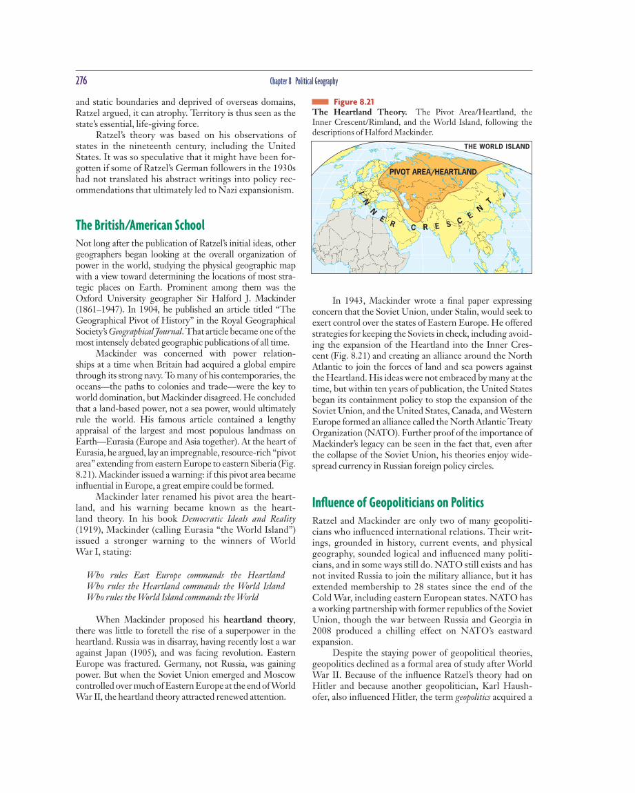
276 Chapter 8 Political Geography
In 1943, Mackinder wrote a fi nal paper expressing concern that the Soviet Union, under Stalin, would seek to exert control over the states of Eastern Europe. He offered strategies for keeping the Soviets in check, including avoid-ing the expansion of the Heartland into the Inner Cres-cent (Fig. 8.21) and creating an alliance around the North A t lantic to join the forces of land and sea powers against the Heartland. His ideas were not embraced by many at the time, but within ten years of publication, the United States began its containment po l icy to stop the expansion of the Soviet Union, and the United States, Canada, and Western Europe formed an alliance called the North Atlantic Treaty Organization (NATO). Further proof of the importance of Mackinder’s legacy can be seen in the fact that, even after the collapse of the Soviet Union, his theories enjoy wide-spread currency in Ru s sian foreign po l icy circles.
Infl uence of Geopoliticians on Politics Ratzel and Mackinder are only two of many geopoliti-cians who infl uenced international relations. Their writ-ings, grounded in history, current events, and physical geography, sounded logical and infl uenced many politi-cians, and in some ways still do. NATO still exists and has not invited Russia to join the military alliance, but it has extended membership to 28 states since the end of the Cold War, including eastern European states. NATO has a working partnership with former republics of the Soviet Union, though the war between Russia and Georgia in 2008 produced a chilling effect on NATO’s eas t ward expansion.
Despite the staying power of geopolitical theories, geopolitics declined as a formal area of study after World War II. Because of the infl uence Ratzel’s theory had on Hitler and because anot h er geopolitician , Karl Haush-ofer , also infl uenced Hitler, the term geopolitics acquired a
and static boundaries and deprived of overseas domains, Ratzel argued, it can a t rophy. Territory is thus seen as the state’s essential, life-giving force.
Ratzel’s theory was based on his observations of states in the nineteenth century, including the United States. It was so speculative that it might have been for-gotten if some of Ratzel’s German followers in the 1930s had not translated his abstract writings into policy rec-ommendations that ult i mately led to Nazi expansionism.
The British/American School Not long after the publication of Ratzel’s initial ideas, other geographers began looking at the overall organiz a tion of power in the world, studying the physical geographic map with a view toward determining the locations of most stra-tegic places on Earth. Prominent among them was the Oxford University geo g rapher Sir Halford J. Mackinder (1861–1947). In 1904, he published an article titled “The Geographical Pivot of History” in the Royal Geographical Society’s Geographical Journal. That article became one of the most i n tensely debated geographic publications of all time.
Mackinder was concerned with power relation-ships at a time when Britain had acquired a global empire through its strong navy. To many of his contemporaries, the oceans—the paths to colonies and trade—were the key to world domination, but Mackinder disagreed. He concluded that a land-based power, not a sea power, would ultimately rule the world. His famous article contained a lengthy appraisal of the largest and most populous landmass on Earth—Eurasia (Europe and Asia together). At the heart of Eurasia, he argued, lay an impre g nable, resource-rich “pivot area” extending from eastern Europe to eastern Siberia (Fig. 8.21). Mackinder i s sued a warning: if this pivot area became infl uential in Europe, a great empire could be formed.
Mackinder later renamed his pivot area the heart-land, and his warning became known as the heart-land theory. In his book Democratic Ideals and Reality (1919), Mackinder (calling Eurasia “the World Island”) i s sued a stronger warning to the winners of World War I, stating:
Who rules East Europe commands the Heartland Who rules the Heartland commands the World Island Who rules the World Island commands the World
When Mackinder proposed his heartland theory, there was little to foretell the rise of a superpower in the heartland. Russia was in disarray, having recently lost a war against Japan (1905), and was facing revolution. Eastern Europe was fractured. Germany, not Russia, was gaining power. But when the Soviet Union emerged and Moscow controlled over much of Eastern Europe at the end of World War II, the heartland theory a t tracted renewed attention.
Figure 8.21The Heartland Theory. The Pivot Area/Heartland, the Inner Crescent/Rimland, and the World Island, following the descriptions of Halford Mackinder.
V
PIVOT AREA/HEARTLAND
THE WORLD ISLAND
IN
N
ER C R E S C
EN
T

How Does the Study of Geopolitics Help Us Understand the World? 277
Statements such as these are rooted in a particular geopolitical perspective on the world—one that divides the globe into opposing camps. That much may seem obvious, as there are clear ideological fault lines between an organization such as al-Qaeda and a state such as the United States. But critical geopolitics seeks to move beyond such differences to explore the spatial ideas and understandings that undergird particular political per-spectives and that shape policy approaches.
One of the most powerful geopolitical ideas since Samuel Huntington published The Clash of Civilizations and the Remaking of World Order in 1996 posits an “Islamic World.” September 11, 2001 amplifi ed the idea of a threat-ening Islamic realm. The U.S. government, concerned about al-Qaeda’s infl uence in the Islamic World, justifi ed military involvement in Iraq and Afghanistan. The idea of a unifi ed “Islamic World” appears in the words of com-mentators on 24-hour news channels. The problem with such conceptions is that the “Islamic World” is tremen-dously diverse, cult u rally, and reli g iously, and some of the most intractable confl icts of recent times have been fought within the I s lamic World. Belief in or fear of a uni-fi ed “Islamic World” is not any more rational than belief in or fear of a unifi ed “Christian World.” Regardless, if geopolitical ideas are believed, they shape the policies that are pursued and how we perceive what happens on the ground. An important task for geographers, then, is to understand the ideological roots and implications of geo-political reasoning by intelle c tuals of statecraft.
Geopolitical World Order Political geographers study geopolitical world orders, which are the temporary periods of stability in the way international politics is conducted. For example, during the Cold War, the geopolitical world order was bipolar—the Soviet Union and its Warsaw Pact satellites versus the United States and its close allies in Western E u rope. In the past, after a stable geopolitical world order broke down, the world went through a transition, eventually se t- tling into a new geopolitical world order. Noted political geographers Peter J. Taylor and Colin Flint argue that at the end of World War II, fi ve possible orders could have emerged among the three major powers, the United King-dom, the United States, and the Soviet Union. Each could have created its own bloc with its own allies; the three could have come together under the United Nations; or three possible alliances could have occurred—the United States and USSR against the UK, the United States and the UK against the USSR, or the UK and USSR against the United States. What emerged was the bipolar world order of the Cold War: the Uni t ed States and the UK against the USSR.
After the Soviet Union collapsed in 1991, the world entered a transition period, again opening up a var i ety of different geopolitical possibilities. Some politicians spoke
negative connotation. For some decades after World War II, the term was in such disrepute that few political geog-raphers, even those studying power rel a tionships, would identify themselves as students of geopolitics. Time, along with more balanced perspectives, has reinstated geopoli-tics as a signifi cant fi eld of study, encompassing efforts to understand the spatial and territorial dimensions of power relationships past, present, and f u ture.
Critical Geopolitics Rather than focusing their attention on predicting and prescribing, many current students of geopolitics focus on revealing and explaining the underlying spatial assumptions and territorial perspectives of international actors. Political geographers Gearoid O’Tuathail and John Agnew refer to those actors in the most powerful states, the core states, as “intellectuals of statecraft.” The basic concept behind criti-cal geopolitics is that intellectuals of statecraft construct ideas about geographical circumstances and places, these ideas i n fl uence and reinforce their political behaviors and policy choices, and then affect what happens and how most people interpret what ha p pens.
O’Tuathail has focused particular attention on Ameri-can geopolitical reasoning—examining speeches and state-ments by U.S. intellectuals of statecraft. He has drawn atten-tion to how several American leaders often spatialize politics into a world of “us” and “them.” Political leaders can shape how their constituents see places and organize international space in their minds. By drawing on American cultural logic and certain represent a tions of America, O’Tuathail argues that presidents have repeatedly defi ned an “us” that is pro-democracy, indepe n d ent, self-suffi cient, and free and a “them” that is in some way against all of these things.
During the Cold War, President Ronald Reagan coined the term Evil Empire for the Soviet Union and represented the United States as “the shining city on a hill.” During ensuing presidencies, terrorism replaced the Soviet Union as the “they.” Sounding remarkably similar, Democratic President William J. Clinton and Repu b li-can President George W. Bush justifi ed military actions against terrorists. In 1998, President Clinton justifi ed American military action in Sudan and Afghanistan as a response to terrorist plans by Osama bin Laden by no t ing that the terrorists “come from diverse places but share a hatred for democracy, a fanatical glorifi cation of violence, and a horrible distortion of their religion, to justify the murder of innocents. They have made the Uni t ed States their adversary precisely because of what we stand for and what we stand against.” Immediately after September 11, President George W. Bush made a similar claim, argu-ing that “They [the terrorists] stand against us because we stand in their way.” In 2002, President Bush again explained, “I’ve said in the past that nations are either with us or against us in the war on te r ror.”

278 Chapter 8 Political Geography
we will discuss in Chapter 9, global cities may gain increas-ing power over issues typ i cally addressed by states.
Read a major newspaper (in print or online) and look for a recent statement by a world political leader regarding interna-tional politics. Using the concept of critical geopolitics, deter-mine what geopolitical view of the world the leader has—how does he or she view and divide up the world spatially?
WHAT ARE SUPRANATIONAL ORGANIZATIONS, AND WHAT ARE THEIR IMPLICATIONS FOR THE STATE? Ours is a world of contradictions. Over the past
couple of decades some French Canadians, Quebeçois , have demanded indepen d ence from Canada even as Canada joined the United States and Mexico in NAFTA (the North American Free Trade Agreement). Flemings in northern Belgium called for autonomy or even inde-pen d ence despite the fact that Brussels, the capital of Bel-gium (and Flanders), serves as the de facto capital of the European Union. At every turn we are reminded of the interconnectedness of nations, states, and regions; yet, separatism and calls for a u tonomy are rampant. In the early decades of the twenty-fi rst century, we appear to be caught between the forces of division and unifi cation.
Despite confl icts arising from these contradictory forces, today hardly a country exists that is not involved in some supran a tional organization. A supranational organization is an entity composed of three or more states that forge an association and form an administra-tive structure for mutual benefi t and in pursuit of shared goals. The twentieth century witnessed the establishment of numerous supranational associations in p o litical, eco-nomic, cultural, and military spheres.
Today, states have formed over 60 major suprana-tional organizations (such as NATO and NAFTA), many of which have subsidiaries that bring the total to more than 100 (Figure 8.22). The more states participate in such mu l tilateral associations, the less likely they are to act alone in pursuit of a self-interest that might put them at odds with neighbors. And in most cases participation in a supranational entity is advantageous to the partners, and being left out can have serious negative implic a tions.
From League of Nations to United Nations The modern beginnings of the supranational move-ment can be traced to conferences following World
optimistically about a new geopolitical world order where a standoff of nuclear terror between two superpowers would no longer determine the destinies of states. Sup-posedly, this new geopolitical order would be shaped by the forces that connect nations and states; by s u pranational entities like the European Union (discussed in the next section of this cha p ter); and, should any state violate inter-national rules of conduct, by multilateral military action. The risks of nuclear war would r e cede, and negoti a tion would replace confrontation. When a United Nations coalition of states led by the United States in 1991 drove Iraq out of Kuwait, the framework of a New World Order seemed to be taking shape. The Soviet Union, which a few years before was the United States’ principal geopolitical antagonist, endorsed the operation. Arab as well as non-Arab forces helped repel the i n vaders.
Soon, however, doubts and uncertainties began to cloud hopes for a mutually cooperative geopolitical world order. Although states were more closely linked to each other than ever before, national self-interest still acted as a powerful force. Nations wanted to become states, and many did, as the number of United Nations members increased from 159 in 1990 to 184 by 1993 and 192 as of 2006. At the same time, a variety of organ i za-tions not tied to specifi c territories posed a new challenge to the territorially defi ned state. The number and power of economic and social networks that extend across state borders increased. The new world order i n cludes non-state organizations with political agendas that are not channeled through states and are often spatially diffuse.
Some hoped to see a geopolitical world order based on unilateralism, with the United States in a position of hard-power dominance and with allies of the United States following rather than joining the political decision-making process. The U.S. military budget is as large as all the military budgets of all other states in the world com-bined. The United States’ controversial invasion of Iraq signifi cantly undermined its infl uence in many parts of the globe. Southeast Asian states that had long been oriented toward the United States began to turn away. A signifi -cant rift developed across the Atlantic between the United States and some European cou n tries, and anti-American-ism surged around the world. The processes of globaliza-tion, the diffusion of nu c lear weapons, the emergence of China and India as increasingly signifi cant powers, and the growth of networked groups and organizations, including terrorist groups, also challenged American unilateralism.
When geopolitical strategists and intellectuals of statecraft predict future geopolitical orders, they often assume that individual states will continue to be the domi-nant actors in the international arena. Yet as we discuss later in this chapter, many of the same forces that worked against American unilateralism have undermined some of the tra-ditional powers of the state. The rise of regional blocs could lead to a new multip o lar order, with key clusters of states functioning as major geopolitical nodes. Alternatively, as

What Are Supranational Organizations, and What Are Their Implications for the State? 279
Universal Declaration on Human Rights, the C o venant on Civil and Political Rights, and the Covenant on Eco-nomic and Social Rights, set a precedent and laid the groundwork for countless human rights groups working in the world today.
By participating in the United Nations, states commit to internationally approved standards of behavior. Many states still violate the standards embodied in the United Nations Charter, but such violations can lead to collective action, such as economic sanctions or Security Council-supported military action. The United N a tions’ actions in South Africa (Apartheid) and Iraq (the Gulf War) are examples of UN success, but the organ i zation has its crit-ics as well. Some argue that the composition of its Security Council refl ects the world of 1950 more than the world of today. Others express concern about power being vested in an organization that is not directly respo n sible to voters and that provides little room for non-state interests. Still oth-ers criticize the fact that states like Iran, Cuba, and North Korea sit on the organization’s Human Rights Council. For all its wea k nesses, however, the United Nations represents the only truly international forum for addressing many sig-nifi cant pro b lems co n fronting the globe.
Regional Supranational Organizations The League of Nations and the United Nations are global manifestations of a phenomenon that is expressed even more strongly at the regional level. States organize supra-national organizations at the regional scale to p o sition themselves more strongly economically, politically, and even militarily.
Belgium, the Netherlands, and Luxembourg under-took the fi rst major modern experiment in regional eco-nomic cooperation. The three countries have much in common culturally and economically. Dutch farm prod-ucts are sold on Belgian markets, and Belgian industrial goods go to the Netherlands and Luxembourg. Dur-ing World War II, representatives of the three countries decided to create common tariffs and eliminate i m port licenses and quotas. In 1944, even before the end of the war, the governments of the three states met in London to sign an agreement of cooperation, creating the Benelux (Belgium, the Netherlands, and Luxembourg) region.
Following World War II, U.S. Secretary of State George Marshall proposed that the United States fi nance a European recovery program. A committee representing 16 Western European states plus (then) West Germany presented the United States Congress with a joint pro-gram for economic rehabilitation, and Congress approved it. From 1948 to 1952, the United States gave Europe about $12 billion under the Marshall Plan, the largest foreign aid program in history. This investment revived European national economies and spurred a movement toward cooperation among E u ropean states.
War I. Woodrow Wilson, president of the United States, proposed an international organization that would include all the states of the world (fewer than 75 states existed at that point), leading to the creation of the League of N a tions in 1919. Even though it was the idea of an American president, the United States was among the countries that did not join this organiza-tion because isolationists in the U.S. Senate opposed joining. In all, 63 states participated in the League, although the total membership at any single time never reached that number. Costa Rica and Brazil left the League even before 1930; Germany departed in 1933, shortly before the S o viet Union joined in 1934. The League later expelled the Soviet Union in 1939 for invading Finland. The League was born of a world-wide desire to prevent future aggression, but the fail-ure of the United States to join dealt the organization a severe blow. In the mid-1930s, the League had a major opportunity when Ethiopia’s Haile Selassie made a dra-matic appeal for help in the face of an invasion by Italy, a member state until 1937. The League failed to take action, and in the chaos of the beginning of World War II the organization collapsed.
Even though the League of Nations ceased func-tioning, it spawned other supranational organizations. Between World War I and World War II, states cre-ated the Permanent Court of International Justice to adjudicate legal issues between states, such as bound-ary disputes and fi shing rights. The League of Nations also init i ated international negotiations on maritime boundaries and related aspects of the law of the sea. The confe r ences organized by the League laid the ground-work for the fi nal resolution of the size of territorial seas de c ades later.
After World War II, states formed a new organi-zation to foster international security and cooperation: the United Nations (UN). Membership in the UN has grown signifi cantly since its inception in 1947 (Fig. 8.23). A handful of states still do not belong to the United Nations, but with the most recent additions in 2006, it now has 192 member states. The United Nations orga-nization includes numerous less visible but nonetheless signifi cant subsidiaries, including the FAO (Food and Agriculture Organization), UNESCO (United Nations Educ a tional, Scientifi c and Cultural Organization), and WHO (World Health Organization). Not all United N a tions members participate in every United Nations subsidiary, but many people around the world have ben-efi ted from their work.
We can fi nd evidence of the United Nations’ work in the “world” section of any major newspaper. UN peacekeeping troops have helped maintain stability in some of the most contentious regions of the world. The United Nations High Commissioner on Refugees is called upon to aid refugees in crises in far-fl ung places. UN documents on human rights standards, such as the

280 Chapter 8 Political Geography
eliminations of certain tariffs and a freer fl ow of labor, capi-tal, and commodities beyond steel. This led, in 1958, to the cre a tion of the European Economic Community (EEC).
The success of the EEC induced other countries to apply for membership. Denmark, Ireland, and the United Kingdom joined in 1973, Greece in 1981, and Spain and Portugal in 1986. The organization became known as the European Community (EC) because it began to address issues beyond economics. By the late 1980s, the EC had 12 members: the three giants (Germany, France, and the United Kingdom); the four southern countries (Italy, Spain, Portugal, and Greece); and fi ve smaller states (the Netherlands, Belgium, Lux-embourg, Denmark, and Ireland). These 12 members
The European Union From the European states’ involvement in the Marshall Plan came the Organization for European Economic Cooperation (OEEC), and this body in turn gave rise to other cooperative organizations. Soon after Europe e s tab-lished the OEEC, France proposed the creation of a Euro-pean Coal and Steel Community (ECSC) with the goal of lifting the restrictions and obstacles that impeded the fl ow of coal, iron ore, and steel among the mai n land’s six primary producers: France, West Germany, Italy, and the three Benelux countries. The six states entered the ECSC, and gradually, through negotiations and agreement, enlarged their sphere of cooperation to i n clude reductions and even
Tropic of Cancer
Equator
Tropic of Capricorn
60°
40°40°
20°20°20°
0°
20° 20° 20°
40°
60°
40°
60°
40°
60°
40°
60°160° 140° 120° 80° 60° 40°
20°
P A C I F I C
O C E A N
A T L A N T I C
O C E A N
SOUTHERNOCEAN
CANADA
UN I TED ST ATESOF AMER ICA
U.S.(Alaska)
GREENLAND
MEXICO
BERMUDA
GUATEMALA
BELIZE
EL SALVADOR
HONDURAS
NICARAGUA
COSTA RICAPANAMA
JAMAICA
BAHAMAS
CUBA
HAITI
DOMINICANREPUBLIC
PUERTORICO
BARBADOS
TRINIDAD & TOBAGO
VENEZUELA
COLOMBIA
ECUADOR
PERU
BOLIVIA
BRAZIL
FRENCH GUIANASURINAME
GUYANA
PARAGUAY
URUGUAY
ARGENTINA
CHILE
U.S.(Hawai’i)
Agadir Agreement
Andean Community
Asia-Pacific Economic Cooperation
Asia-Pacific Trade Agreement
Association of South East AsianNations
Caribbean Community andCommon Market
Central American Common Market
Central American-DominicanFree Trade Agreement
Common Market for Eastern andSouthern Africa
Commonwealth of IndependentStates
East African Community
Economic and MonetaryCommunity of Central Africa
Economic Community ofWest African States
European Community
European Customs Union(Andorra, Monaco, San Marino,and Turkey)
European Free Trade Association
Gulf Cooperation Council
North American Free TradeAgreement
South Africa Customs Union
South Africa DevelopmentCommunity
South Asian Preferential TradeArrangement
Southern Common Market
SELECT SUPRANATIONALORGANIZATIONS
Striped coloring representsmembership in two organizations
0
0 20001000 3000 Kilometers
1000 2000 Miles
Figure 8.22 Select Supranational Organizations. Data from: Crawford, Jo-Ann and Roberto V. Fiorentino “Changing Landscape of Regional Trade Agreements,” World Trade Organization. http://www.wto.org/english/res_e/booksp_e/discussion_papers8_e.pdf

What Are Supranational Organizations, and What Are Their Implications for the State? 281
because of the diversity of the states involved. For example, agricultural practices and pol i cies have always varied widely. Yet some general policy must govern agriculture through-out the European U n ion. Individual states have found these adjustments diffi cult at times, and the EU has had to devise policies to accommodate regional contrasts and delays in implementation. In addition, integration requires signifi cant expenditures. Under the rules of the EU, the richer coun-tries must subsidize (provide fi nancial support to) the poorer ones; therefore, the entry of eastern European states adds to the fi nancial burden on the wealthier western and northern European members. Recent fi nancial crises in Greece and Ireland have put the union under u n precedented pressure, as wealthier countries such as Germany question why they should foot the bill for cou n tries that have not (at least in German eyes) managed their fi nances responsibly.
initiated a program of cooperation and unifi cation that led to the formal establishment of a European Union (EU) in 1992. In the mid-1990s, Austria, Sweden, and Finland joined the EU, bringing the total number of members to 15 (Fig. 8.24).
In the late 1990s, the EU began preparing for the establishment of a single currency—the euro (Fig. 8.25). First, all electronic fi nancial transactions were denomi-nated in euros, and on January 1, 2002, the EU introduced euro coins and notes. Not all EU me m ber states are cur-rently a part of the euro-zone, but the euro has emerged as a signifi cant global currency.
The integration of ten eastern European and Mediter-ranean island states into the European Union in 2004, and two more in 2007, is a signifi cant development. Integration is a diffi cult process and often requires painful adjustments
Tropic of Cancer
Arctic Circle
Equator
Tropic of Capricorn
Antarctic Circle
60° 60°
40°40°
20°
0°
20° 20° 20° 20°
40°
60°
40°
60°
40°
60° 60°0° 20° 40° 60° 100° 120° 140° 160°
A T L A N T I C
O C E A N
I N D I A N
O C E A N
P A C I F I C
O C E A N
SOUTHERN OCEAN
A T L A N T I C
O C E A N SLOVENIA
MACEDONIA
CROATIABOSNIA
MONTENEGROKOSOVO
LUX.CZECH REP. SLOVAKIA
GREENLAND
ICELAND
IRELAND
UNITED KINGDOM
PORTUGAL SPAIN
FRANCE
BELG.
NETH.
GER. POLAND
ITALY
SWITZ. AUS.ROM.
BULG.
ALBANIA
GREECE TURKEY
CYPRUS
HUNG.
NORWAYSWEDEN
FINLAND
DENMARK
ESTONIA
LITHUANIA
LEBANONMOROCCO
ALGERIALIBYA
TUNISIA
EGYPT
SUDAN
SOUTHSUDAN
CHADNIGERMALI
MAURITANIA
ETHIOPIA
DJIBOUTI
SOMALIA
SENEGALGAMBIA
GUINEA-BISSAU GUINEA
SIERRALEONE
LIBERIA
GHANA
IVORYCOAST
TOGOBENIN
NIGERIA
CAMEROON
BURKINAFASO
CENTRALAFRICAN REP.
THECONGO
CONGOGABONEQUATORIAL
GUINEA
UGANDAKENYA
TANZANIA
RWANDA
BURUNDI
ANGOLAZAMBIA MALAWI
MOÇAMBIQUEZIMBABWE
BOTSWANANAMIBIA
SOUTHAFRICA LESOTHO
SWAZILAND
MADAGASCAR
MAURITIUS
COMOROS
LATVIA
BELARUS
UKRAINEMOLDOVA
RUSSIA
GEORGIA
ARMENIAAZERBAIJAN TURKMENISTAN
UZBEKISTAN
KAZAKHSTAN
KYRGYZSTAN
TAJIKISTAN
MONGOLIA
IRAN
CHINA
IRAQ
SYRIA
JORDANISRAELKUWAIT
SAUDIARABIA
QATARBAHRAIN
U.A.E.
OMAN
YEMEN
AFGHANISTAN
PAKISTAN
INDIA
NEPAL
SRI LANKA
BHUTAN
BANGLADESH
MYANMAR
THAILAND
CAMBODIA
LAOS
VIETNAM
TAIWAN
M A L A Y S I A
BRUNEI
PHILIPPINES
I N D O N E S I A
PAPUANEW
GUINEA
AUSTRAL I A
N EWZ EA LA N D
JAPAN
N.KOREA
S.KOREA
NEWCALEDONIA
VANUATU FIJI
SINGAPORE
ERITREA
WESTERNSAHARA
EASTTIMOR
SERBIA

282 Chapter 8 Political Geography
thereby widening the organization’s reach. The govern-ment of Turkey has long sought to join, but many Greeks are hesitant to support Turkish membership because of the long-standing dispute between Greece and Turkey over Cyprus and a number of islands off the Turkish coast. Other EU me m bers have expressed concern over Turkey’s human rights record, specifi cally its treatment of Kurds and its reluctance to recognize the extent of the mass kill-ing of Armenians in World War I. Behind these claims lies an often-unspoken sense among many Europeans that Turkey is not “European” enough to warrant membership, perhaps rooted in a historical and cultural tendency to d e fi ne Muslims as the “Ot h er.” The d e bate within the EU
The Union is a patchwork of states with many different ethnic traditions and histories of confl ict and competition, and some in Europe express concern over losing traditional state powers. Ec o nomic success and growing well-being tend to submerge hesitancy and differences, but in the face of diffi cult economic or social times, divisive forces can, and have, reasserted themselves. Moreover, as the EU gets big-ger, it becomes increasingly diffi cult for individual states (even powerful ones) to shape the dire c tion of the union. And some citizens in smaller states such as Denmark and Sweden worry about getting lost in the mix.
Another diffi cult problem involves Turkey. Some western Europeans would like to see Turkey join the EU,
60°
40°
20°
20°
0°
40°
60°160° 140° 120°
60°
40°
20° 20°
40°
60°80° 60° 40°
60°
40°
Tropic of Capricorn
Equator
Tropic of Cancer
40°
20°
S O U T H E R NO C E A N
P A C I F I C
O C E A N
AT L A N T I C
O C E A N
U.S.(Hawaii)
U.S.(Alaska)
CANADA
GREENLAND
UN I TED STATES
MEXICO
BERMUDA
BAHAMAS 1973
CUBAJAMAICA
1962BELIZE 1971
NICARAGUA
HONDURASGUATEMALA
EL SALVADOR
PANAMACOSTA RICA
ECUADOR
COLOMBIA
VENEZUELA
GRENADA1974
PUERTORICO
ST. KITTS & NEVIS 1983ANTIGUA & BARBUDA 1981
DOMINICA 1978ST. LUCIA 1979
BARBADOS 1966ST. VINCENT & THE GRENADINES
1980TRINIDAD & TOBAGO 1962
SURINAME 1975FRENCH GUIANA
DOMINICANREPUBLIC
HAITI
GUYANA1966
PERU BRAZIL
BOLIVIA
PARAGUAY
ARGENTINA
CHILE URUGUAY
THE UNITED NATIONS
Charter members, 1945
Members after 1945 with dates of entry
Nonmembers
0
0
1000
1000
2000 3000 Kilometers
2000 Miles
Figure 8.23 Member States of the United Nations. This map shows charter members, members after 1945 (with dates of entry), and nonmembers of the United Nations. Data from: the United N a tions,
www.un.org

What Are Supranational Organizations, and What Are Their Implications for the State? 283
Asia-Pacifi c Economic Council (APEC), and the Com-monwealth of Ind e pendent States (CIS), have drawn up treaties to reduce tariffs and import restrictions in order to ease the fl ow of commerce in their regions. Not all of these alliances are successful, but economic suprana-tionalism is a sign of the times, a grand experiment still in progress.
Yet, when we turn back to the European Union, we see a supranational organization that is unlike any other. It is not a state, nor is it simply an o r ganization of states. The European Union is remarkable in that it has taken on a life of its own—with a multifaceted government structure, three capital cities, and billions of euros fl owing through
about Turkey has alienated many Turkish people, causing them to que s tion their support for EU membership.
How Does Supranationalism Affect the State? Supranationalism is a worldwide phenomenon. Other economic associations, such as the North American Free Trade Agreement (NAFTA), the Association of Caribbean States (ACS), the Central American Com-mon Ma r ket, the Andean Group, the Southern Cone Community Market (MERCOSUR), the Economic Community of West African States (ECOWAS), the
20° 20°
40°
60°0° 20° 40°
Antarctic Circle
60°60°
Tropic of Capricorn
40°
20° 20°
40°
60°100° 120° 140° 160°
60°
40°
60°
Arctic Circle
60°
40°
20°
0°
20°
Tropic of Cancer
Equator
ATLANTIC
OCEAN
AT L A N T I C
O C E A N
S O U T H E R N
I N D I A N
O C E A N
O C E A N
P A C I F I C
O C E A N
GREENLAND
ICELAND1946
UNITED KINGDOM
IRELAND1955
SWEDEN1946
NORWAYFINLAND
1955
DENMARKNETH.
GER.1973
ESTONIA 1991LATVIA 1991
LITHUANIA 1991
BELARUS (1992)MOLDOVA
1992
RUSSIA(1992)
KAZAKHSTAN1992
UZBEKISTAN1992
TURKMENISTAN1992
SYRIA
MAC.1993
HUNG.1955 ROM.
1955
SLVK.1993AUSTRIA
1955
POLANDCZ.
1993
ITALY1955
SWITZ.2002
FRANCE
SPAIN1955
CROATIA 1992SLOVENIA 1992
BOSNIA 1992
TUNISIA1956
MONT. 2006
BELG. UKRAINE(1992)
BULG. 1955PORTUGAL
1955
MOROCCO1956
ALGERIA1962WESTERN
SAHARA
CAPEVERDE1975
ISRAEL1949
EGYPTLIBYA1955
TURKEY
GEORGIA1992
ARMENIA1992
SERB.KOS.
ALB.1955
GREECE
CYPRUS1960LEBANON
MAURITANIA1961 MALI
1960 NIGER1960 CHAD
1960
SUDAN1956
SOUTHSUDAN2011
ERITREA1993
YEMEN1990
DJIBOUTI1977
C.A.R.1960
SENEGAL 1960GAMBIA1965
GUINEA-BISSAU1974SIERRA LEONE
1961LIBERIA
CÔTED’IVOIRE
1960
BURKINAFASO 1960GUINEA
1958 NIGERIA1960
GHANA1957
TOGO1960 BENIN
1960SÃO TOMÉ & PRINCIPE 1975
EQUATORIALGUINEA1968
GABON1970
CAMEROON1960 UGANDA
1962RWANDA
1962
ETHIOPIA
SOMALIA1960
KENYA1963
DEM. REP. CONGO1960
CONGO1960
SOUTHAFRICA
NAMIBIA1991
ZIMBABWE 1980
ZAMBIA1964
ANGOLA1976
COMOROS1975
MAURITIUS1968
MADAGASCAR1960
SWAZILAND 1968
LESOTHO 1966
BOTSWANA1966
TANZANIA1961
BURUNDI 1962
MALAWI1964
OMAN1971
QATAR1971 U.A.E.
1971
BAHRAIN1971
JORDAN1955 PAKISTAN
1947
AFGHANISTAN1946
IRAN
AZERBAIJAN1992
SAUDIARABIA
KUWAIT1963
IRAQ
MONGOLIA1961
KYRGYZSTAN 1992
TAJIKISTAN 1992CHINA1971
BHUTAN1971
NEPAL1955
BANGLADESH1974
INDIA
SRI LANKA1955
N.KOREA1991
S.KOREA1991
JAPAN1956
MYANMAR(BURMA)
1948LAOS1955
VIETNAM1977
THAILAND1946
CAMBODIA1955
TAIWAN1945–1971
PHILIPPINES
BRUNEI1984
M A L A Y S I A1957
SINGAPORE1965
I N D O N E S I A1950
EAST TIMOR2002
AUSTRAL I A
PAPUANEW
GUINEA1975
SOLOMON IS.1978
VANUATU1981
NEWCALEDONIA
FIJI1970
NEWZEALAND
MOCAMBIQUE1975¸

284 Chapter 8 Political Geography
state governments. With the European Union, we may be witnessing a transformation to a new political geographic construct that signifi es a change in the political organiza-tion of space similar to the transformation to the modern state system that occurred in Europe in the seventeenth ce n tury.
Other movements in addition to the European Union are posing major challenges to the state as we know it and raising questions as to whether the division of the world into territorial states is logical, effective, or
its coffers. The European Union is extending into foreign relations, domestic policies, and mil i tary policies, with sovereignty over certain issues moving from the states to the European Union. One of the authors of this book has studied the degree to which Europeans in some regions are fee l ing a greater a t tachment to their region and to the European Union than to their own state (Fig. 8.26). Identifying with the European U n ion (over the state) is strong in the Benelux countries (the fi rst members) and in regions where people have been disempowered by their
M e d i t e r r a n e a n S e a
No r th
Sea
ATLANTIC OCEAN
A R C T I C O C E A N
Black Sea
Baltic
Sea
RUSSIA
CZECHREPUBLIC
SLOVAKIA
ROMANIA
MOLDOVA HUNGARY
AUSTRIA1995
SLOVENIA
CROATIA
BOSNIA
ALBANIA
SERBIA
KOSOVO
MACE-DONIA
GREECE1981
2004
BULGARIAITALY
1990
POR
TUGA
L
LIECHTENSTEIN
BELGIUM
Arctic Circle
20° 10° 0° 10° 20° 30°
50°
40°
20° 30°10°0°
40°
50°
60°
MALTA
POLAND
UKRAINE
BELARUS
SPAIN 1986 1986
FRANCE SWITZERLAND
LUXEMBOURG
GERMANY
UNITED KINGDOM 1973
IRELAND 1973
NETHERLANDS
DENMARK 1973
NORWAY
SWEDEN 1995
FINLAND
1995
2004
2004
2004
2004
2004
2004
2004
2004
2004
ESTONIA
LATVIA
LITHUANIA
ICELAND
RUSSIA
TURKEY
CYPRUS
Longitude East of Greenwich
MONTENEGRO
2007
2007
EUROPEAN UNIFICATION
600 Kilometers2000 400
300 Miles1000 200
Later EC/EU members(joined 1973–2007)
Discussions in progress
No early prospects
Countries votingagainst membership
Original EEC members(joined 1958)
Euro adopters as ofJan. 1, 2011
Figure 8.24 European Supranationalism . Members of the European Union and their dates of entry. Data
from: the European Union, www.europa.eu.int ©H. J. de Blij , P. O. Muller, and John W i ley & Sons, Inc.

What Are Supranational Organizations, and What Are Their Implications for the State? 285
or group to pu r chase the power with which to threaten the world.
Although states provide the territorial foundation from which producers and consumers still operate and they continue to exert considerable regulatory powers, economic globalization makes it ever more diffi cult for states to control economic relations, which is an example of deterritorialization . States are respon d ing to this situation in a variety of ways, with some giving up traditional regula-tory powers and others seeking to insulate themselves from the intern a tional economy. Still others are working to build supranational economic blocs that they hope will help them cope with an increasingly globalized world. The impacts of many of these develo p ments are as yet uncertain, but it is increasingly clear that states now compete with a variety of other forces in the intern a tional arena.
The state’s traditional position is being further eroded by the globalization of social and cultural relations. Net-works of interaction are being constructed in ways that do not correspond to the map of states. In 2011, when unrest broke out in Egypt, for example, activists used Facebook to garner support. Scholars and researchers in different countries work together in teams. Increased mobility has brought individuals from far-fl ung places into much closer contact than before. Paralleling all this change is the spread of popular culture in ways that make national borders vir-tually meaningless. Katy Perry is listened to from Iceland to Australia; fas h ions developed in northern Italy are hot items among Japanese tourists visiting South Korea; Thai restaurants are found in towns and cities across the United States; Russians hurry home to watch the next episode of soap o p eras made in Mexico; and movies produced in Hol-lywood are seen on screens from Mumbai to Santiago.
The rise of fundamentalist religious movements with geopolitical goals represents another global phe-nomenon with potentially signifi cant implications for a future world order. In Chapter 6, we noted that fund a- mental religious movements sometimes become extrem-ist by inciting violent acts in the name of their faith. V i olence by extremists challenges the state—whether undertaken by individuals at the local scale or by widely diffused groups spread across major world realms. The state’s mission to combat religious violence can produce support for the state government in the short term, but the state’s inability to defeat extremist attacks may we a ken the state in the long term. Terrorist attacks have been threatened or carried out by religious extremists from a v a riety of different faiths, but the wave of inter-national terrorism that began in the 1980s in the name of Islam has dominated the international scene over the past two decades. The attacks on the World Trade Cen-ter and the Pentagon and the downing of Flight 93 in Pennsylvania, and the invasions of Iraq and Afghanistan that followed, moved terrorism to the ge o political cen-ter stage. More recent terrorist attacks in Madrid, Mos-cow, and Mumbai have helped to keep it there.
even necessary. Among these challenges are the demand of nations within states for independence, economic glo-balization, increasing connectedness among people and cultures, and the proliferation of nuclear weapons.
Nuclear weapons give even small states the ability to infl ict massive damage on larger and distant adversar-ies. Combined with missile technology, this may be the most serious danger the world faces, which is why the United Nations insisted on dismantling Iraq’s nuclear capacity after the 1991 Gulf War and why concerns over Iran’s nuclear program are so great. Some states pub-licize their nuclear weapons programs, whereas other nuclear states have never formally acknowledged that they possess nuclear weapons. Reports of nuclear pro-liferation have led to military actions in the last 30 years. In 1981, when reports of Iraq’s nuclear program reached Israel, the Israelis attacked Iraq. As nuclear weapons have become smaller and “tact i cal” nuclear arms have been d e veloped, the threat of nuclear weapons sales is of growing concern. It is now possible for a hostile state
Figure 8.25 Cortina , Italy. A market in northern Italy adve r tises the price of fruit in euros. © Alexander B. Mu r phy.

286 Chapter 8 Political Geography
the spatial di s tribution of power is more complex than the traditional map of states would suggest. Describing that spatial distribution will be a challenge for geographers for gener a tions to come.
In 2004, the European Union welcomed ten additional states, and in 2007, it welcomed two more. Examine the European Union website (listed below in the Learn More Online section). Read about the European Union’s expansion and what is going on in the European Union right now. Assess how complicated it is for the European Union to bring together these many divergent members into one supranational organization.
All of the foregoing processes are creating eco-nomic, social, and cultural geographies that look less and less like the map of states (Fig. 8.3). The term deterrito-rialization is sometimes used to describe these processes because globalization, networked communities, and the like undermine the state’s traditional territor i al author-ity. But the state is far from disappearing, and national-ism continues to be a fundamental social force in the world today. Indeed, in many instances. the state is mov-ing to solidify control over its territory through a process known as reterritorialization . For example, in response to concerns over illegal immigration, some state borders are becoming more heavily fortifi ed, and moving across those borders is becoming more di f fi cult. However one views the balance between deterrit o rialization and reter-ritorialization , the state of the geopolitical order is clearly in fl ux. We appear to be headed toward a world in which
Figure 8.26 Brussels, Belgium. A woman with a European Union umbrella shops in the fl ower market in the Grande Place of Brussels. Note that the fl ag of the European Union has 12 stars,which recognizes the 12 EuropeanCommunity member states thatcommitted to becoming the European Union in 1992. © Erin
H. Fo u berg .
Summary We tend to take the state for granted, but the modern state idea is less than 400 years old. The idea and ideal of the nation-state have diffused around the globe in the wake of colonialism and the emergence of the modern i n ternational legal order.
The state may seem natural and permanent, but it is not. New states are being rec-ognized, and existing states are vulnerable to destructive forces. How long can this way of politically organizing space last?

Watch It Online 287
political geography state territory territoriality sovereignty territorial integrity mercantilism Peace of Westphalia nation nation-state democracy multinational state multistate nation stateless nation colonialism
scale world-systems theory capitalism commodifi cation core periphery semiperiphery ability centripetal centrifugal unitary federal devolution territorial representation reapportionment
splitting majority-minority
districts gerrymandering boundary geometric boundary physical-political
boundary heartland theory critical geopolitics unilateralism supranational
organization deterritorialization reterritorialization
Geographic Concepts
Learn More Online About Country Studies Published by the United States Library of Congress http://lcweb2.loc.gov/frd/cs/cshome.html
About the European Union http://europ.eu
About Nationalism www.nationalismproject.org
About Political Geography www.politicalgeography.org
Watch It Online Devolution
Slovakia: New Sovereignty. Click on Video on Demand. www.learner.org/resources/series180.html#program_descriptions
International Boundaries
Boundaries and Borderlands. Click on Video on Demand. http://www.learner.org/resources/series180.html#program_descriptions
Supranationalism and the European Union
Strasbourg: Symbol of a United Europe. Click on Video on Demand http://www.learner.org/resources/series180.html#program_descriptions
As we look to arrangements beyond the state, we can turn to the global scale and consider what places the global world economy most affects, shapes, and benefi ts. In the next chapter, we study global cities with major links in the world economy. Global cities dominate their surroundings and connect with each other across the world in many ways that transcend the state.