chapter 5 adaptation and proposal - world...
TRANSCRIPT

CHAPTER 5
ADAPTATION AND PROPOSAL

Climate Change Impact and Adaptation Study for Bangkok Metropolitan Region Final Report Chapter 5: Adaptation and Proposal
5-1
CHAPTER 5 ADAPTATION AND PROPOSAL
5.1 GENERAL Climate change impacts on Bangkok and vicinities are manifested through a higher risk of flooding and consequent effects on economic and social resilience of the area. Flooding is not uncommon in this area and was responsible for severe socio-economic losses in the past. Inhabitants of the area have been adapting to flooding for decades and strategies for managing flood risks have evolved through time. Nevertheless, additional adaptation measures will be required to reduce the adverse impacts of projected climate change and variability. 5.2 REVIEW OF ADAPTIVE PRACTICES A wealth of well-tested experience, information and technology is already available to identify viable adaptation strategies. The Consultant reviewed and analyzed some of the more prominent practices and potential adaptive interventions, such as improving flood forecasting and preparing strategies for flood warnings, evacuation, transport during floods, and post-flood recovery; implementing protection (e.g. construction of dikes/seawalls) or retreat strategies for coastal development; changes in coastal development and land use; public information campaigns and training exercises (Appendix M, page M-1). 5.3 ADAPTATION OPTIONS The adaptation options are intimately connected to social and economic context. At the same time, they are dynamic and influenced by the productive base including natural and man-made capital assets, social networks and entitlements, human capital and institutions, governance, national income, health, and technology. Nevertheless, available options vary unevenly across and within societies. A range of barriers limits the implementation and effectiveness of adaptive measures and even societies with high adaptive capacity remain vulnerable to climate change variability and extremes. To cope with the recurring flooding in Bangkok, the agencies responsible for flood mitigation and drainage works have prepared a number of plans. These plans, in general, consist of structural and non-structural measures. However, in formulating these plans, climate change impact on hydrology was not considered. The results of simulation study revealed that the existing and planned flood protection system would be inadequate to cope with the impacts of flooding greater than a 10-year return period in 2050 and corresponding to the A1FI climate change scenario. 5.3.1 Structural Measures Currently, a number of structural measures are adopted by the concerned agencies to cope with flooding. These are summarized as follows: Polder, Dike, and Monkey Cheek A polder with drainage system improvement covering the Bangkok metropolitan area has been developed and dike construction has progressed continuously along the Chao Phraya River even in rural areas. Moreover, several water conservation or retaining areas (named the Monkey Cheek by His Majesty King Bhumibol) in the western and eastern areas of the Chao Phraya River have been developed. While most of these structural measures are already in place, some are scheduled to be completed in 2011. All existing and on-going measures were included in the study.

Climate Change Impact and Adaptation Study for Bangkok Metropolitan Region Final Report Chapter 5: Adaptation and Proposal
5-2
Constructing Retaining Wall on
the Bank of the Chao Phraya River The Phrakanong Pumping Station
Large Storage Dam in the Upper Basin A large storage dam in the upper basin has been proposed in the past to save Bangkok from flooding. For example, the Kaeng Sua Ten Dam has been proposed and studied several times whenever severe flood damage occurred in the Yom River Basin. Unfortunately, building new dams can be controversial due to their potential social and environmental impact, and therefore are not pursued as good options for flood control. Barrage at the River Mouth A tidal barrage at the mouth of the Chao Phraya River has been proposed and its effectiveness was examined in a previous study (RID, 1999). The barrage and pumps were found to be effective in lowering the floodwater in Bangkok but are not effective in controlling large flood discharge. Furthermore, this measure requires a huge investment cost (131 billion baht in 1998 prices), involves social and environmental problems, and may interfere with navigation. As such, barrage is not considered a suitable option in the long term. Diversion Channel A flood diversion channel from Ayutthaya to the river mouth (the Chao Phraya River II project) was proposed to mitigate flood damage (RID, 1999). Alternative routes were studied. However, due to a complicated land acquisition process and high investment cost (42 billion baht in 1998 for a capacity of 1,100 m3/sec) the proposal was not pursued. In 2006, the RID proposed improvement of existing irrigation canals to divert water and increasing the pumping capacity on the right bank of the Bang Pakong River and on the coast of the Gulf of Thailand (RID, 2006). The latter proposal by the RID was included in the current adaptation plan. Coastal Erosion and Wave Protection The BMA has a plan to construct 10 T-groins along the 4.7-km shoreline at Bang Khun Thian district to protect against coastal erosion (BMA, 2007a). Apart from the T-groins, the BMA will grow mangrove trees to protect the shoreline. At present, more than 760 m of the Bang Khun Thian shoreline has eroded, resulting in a decrease in forest density.
Coastal Erosion T-groins Type Sea Wave Protection Bamboo Type
Climate Change Impact and Adaptation Study for Bangkok Metropolitan Region Final Report Chapter 5: Adaptation and Proposal
5-3
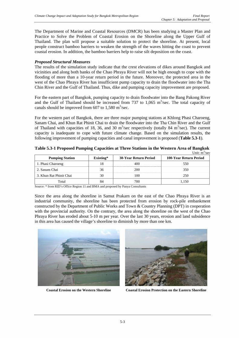
The Department of Marine and Coastal Resources (DMCR) has been studying a Master Plan and Practice to Solve the Problem of Coastal Erosion on the Shoreline along the Upper Gulf of Thailand. The plan will propose a suitable solution to protect the shoreline. At present, local people construct bamboo barriers to weaken the strength of the waves hitting the coast to prevent coastal erosion. In addition, the bamboo barriers help to raise silt deposition on the coast. Proposed Structural Measures The results of the simulation study indicate that the crest elevations of dikes around Bangkok and vicinities and along both banks of the Chao Phraya River will not be high enough to cope with the flooding of more than a 10-year return period in the future. Moreover, the protected area in the west of the Chao Phraya River has insufficient pump capacity to drain the floodwater into the Tha Chin River and the Gulf of Thailand. Thus, dike and pumping capacity improvement are proposed. For the eastern part of Bangkok, pumping capacity to drain floodwater into the Bang Pakong River and the Gulf of Thailand should be increased from 737 to 1,065 m3/sec. The total capacity of canals should be improved from 607 to 1,580 m3/sec. For the western part of Bangkok, there are three major pumping stations at Khlong Phasi Charoeng, Sanam Chai, and Khun Rat Phinit Chai to drain the floodwater into the Tha Chin River and the Gulf of Thailand with capacities of 18, 36, and 30 m3/sec respectively (totally 84 m3/sec). The current capacity is inadequate to cope with future climate change. Based on the simulation results, the following improvement of pumping capacities and canal improvement is proposed (Table 5.3-1). Table 5.3-1 Proposed Pumping Capacities at Three Stations in the Western Area of Bangkok
Unit: m3/sec Pumping Station Existing* 30-Year Return Period 100-Year Return Period
1. Phasi Charoeng 18 400 550 2. Sanam Chai 36 200 350 3. Khun Rat Phinit Chai 30 100 250
Total 84 700 1,150 Source: * from RID’s Office Region 11 and BMA and proposed by Panya Consultants Since the area along the shoreline in Samut Prakarn on the east of the Chao Phraya River is an industrial community, the shoreline has been protected from erosion by rock-pile embankment constructed by the Department of Public Works and Town & Country Planning (DPT) in cooperation with the provincial authority. On the contrary, the area along the shoreline on the west of the Chao Phraya River has eroded about 5-10 m per year. Over the last 30 years, erosion and land subsidence in this area has caused the village’s shoreline to diminish by more than one km.
Coastal Erosion on the Western Shoreline Coastal Erosion Protection on the Eastern Shoreline
Climate Change Impact and Adaptation Study for Bangkok Metropolitan Region Final Report Chapter 5: Adaptation and Proposal
5-4
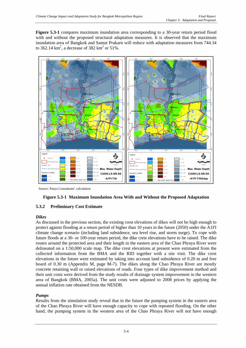
Figure 5.3-1 compares maximum inundation area corresponding to a 30-year return period flood with and without the proposed structural adaptation measures. It is observed that the maximum inundation area of Bangkok and Samut Prakarn will reduce with adaptation measures from 744.34 to 362.14 km2, a decrease of 382 km2 or 51%.
!(
!(
!(
!(
!(
!(
Bangkok
Nonthaburi
Pathum Thani
Samut Sakhon
Samut Prakan
Nakhon Pathom
620000
620000
640000
640000
660000
660000
680000
680000
700000
7000001480
000
1480
000
1500
000
1500
000
1520
000
1520
000
1540
000
1540
000
1560
000
1560
000
1580
000
1580
000
Legend
!( Province
Province Boundary
Dike
River/Canal Network
Elevation (m.MSL)
-7 - -5
-5 - -3
-3 - -1
-1 - 0
0 - 1
1 - 2
2 - 3
3 - 4
4 - 5
5 - 8
8 - 10
10 - 15
15 - 20
20 - 25
> 25
Max.Water Depth (cm)
0 - 10
10 - 50
50 - 100
100 - 200
200 - 300
300 - 400
> 400
Ê0 4 8 12 162
Kilometers
!(
!(
!(
!(
!(
!(
Bangkok
Nonthaburi
Pathum Thani
Samut Sakhon
Samut Prakan
Nakhon Pathom
620000
620000
640000
640000
660000
660000
680000
680000
700000
7000001480
000
1480
000
1500
000
1500
000
1520
000
1520
000
1540
000
1540
000
1560
000
1560
000
1580
000
1580
000
Legend
!( Province
Province Boundary
Dike
River/Canal Network
Elevation (m.MSL)
-7 - -5
-5 - -3
-3 - -1
-1 - 0
0 - 1
1 - 2
2 - 3
3 - 4
4 - 5
5 - 8
8 - 10
10 - 15
15 - 20
20 - 25
> 25
Max.Water Depth (cm)
0 - 10
10 - 50
50 - 100
100 - 200
200 - 300
300 - 400
> 400
Ê0 4 8 12 162
Kilometers
Max. Water DepthC2050-LS-SR-SS-A1FI-T30Adap
Max. Water DepthC2050-LS-SR-SS
-A1FI-T30
Source: Panya Consultants’ calculation
Figure 5.3-1 Maximum Inundation Area With and Without the Proposed Adaptation
5.3.2 Preliminary Cost Estimate Dikes As discussed in the previous section, the existing crest elevations of dikes will not be high enough to protect against flooding at a return period of higher than 10 years in the future (2050) under the A1FI climate change scenario (including land subsidence, sea level rise, and storm surge). To cope with future floods at a 30- or 100-year return period, the dike crest elevations have to be raised. The dike routes around the protected area and their length in the eastern area of the Chao Phraya River were delineated on a 1:50,000 scale map. The dike crest elevations at present were estimated from the collected information from the BMA and the RID together with a site visit. The dike crest elevations in the future were estimated by taking into account land subsidence of 0.20 m and free board of 0.30 m (Appendix M, page M-7). The dikes along the Chao Phraya River are mostly concrete retaining wall or raised elevations of roads. Four types of dike improvement method and their unit costs were derived from the study results of drainage system improvement in the western area of Bangkok (BMA, 2005a). The unit costs were adjusted to 2008 prices by applying the annual inflation rate obtained from the NESDB. Pumps Results from the simulation study reveal that in the future the pumping system in the eastern area of the Chao Phraya River will have enough capacity to cope with repeated flooding. On the other hand, the pumping system in the western area of the Chao Phraya River will not have enough
Climate Change Impact and Adaptation Study for Bangkok Metropolitan Region Final Report Chapter 5: Adaptation and Proposal
5-5
capacity. The pumping stations at Phasi Charoen and Sanam Chai should be upgraded to capacities of 400 and 200 m3/sec for floods of a 30-year return period (550 and 350 m3/sec for floods at a 100-year return period) respectively. These two pumping stations will drain the flood water inside the protection area into the Tha Chin River. The pumping station at Klong Khun Rat Phinit Chai should also add capacity to reach 100 and 250 m3/sec for floods at a 30-and 100-year return period respectively. However, drainage canals to convey the flood water from the inundated area to the pumping stations have to be trained. The unit costs of pumping station and drainage canal improvement were derived from the study results of the drainage system improvement in the area around Suvarnabhumi Airport (RID, 2004). Coastal Erosion Protection A number of agencies proposed and compared methods of coastal erosion protection in the past. However, their effectiveness and environmental impact are yet to be thoroughly scrutinized. The BMA (2007a) proposed coastal erosion protection including the rehabilitation of mangrove forest along the shoreline of Bang Khun Thian. In the eastern area of the Chao Phraya River, there are plans to construct rock-pile embankments along the shoreline to protect the industrial community area from coastal erosion and waves. The total estimated costs are 35 and 49 billion baht to protect against floods at a 30- or 100-year return period respectively (Appendix M, page M-12). 5.3.3 Preliminary Economic Evaluation The preliminary economic evaluation of the proposed flood protection improvement project is carried out by comparing the cost and benefits with and without the project in order to identify the incremental benefit of the project. The viability of the project is determined by the economic indicators, i.e., Net Present value (NPV), Economic Internal Rate of Return (EIRR) and Benefit Cost Ratio (B/C). In the analysis the discounted rates of 8%, 10%, and 12% will be used. The analysis period used is 38 years, of which the first 8 years are for studying, designing and construction and 30 years is the economic benefit period of the project. Project Cost: The investment cost of the project includes civil work, pumps, design and contingency and related cost. The detailed design cost is estimated at 0.3% of the project. The total investment cost is estimated at 35.3 billion baht for 30 year return flood protection and 49.5 billion baht for 100 year return flood protection. The annual operation and maintenance cost is estimated at 1% of the civil work and 2.5% of the pump work. The total annual operation and maintenance cost for 30- and 100-year return flood is estimated at 584 and 874 million baht respectively. Project Benefit: The expected benefit of the project is the annual reduction of flood damage cost. In estimating annual benefit, the damage cost at each return flood period from the result of flood damage assessment is used for the calculation taking into account the probability of occurrence of each flood period (Appendix M, Page M-15). The average annual flood damage reduction cost resulting from the proposed project was estimated at 4.4 and 5.9 billion baht for floods at 30-and 100-year return period respectively. It should be noted that if the protection work is designed for floods at a 30-year return period, the full damage will occur when a flood of higher than a 30-year return period happens. Cost Benefit Analysis: The economic viability analysis is carried out for two cases. A base case considers the annual benefit of 4.4 and 5.9 billion baht for floods at a 30-and 100-year return period are constant throughout the analysis period. The other case considers the real value of the infrastructure damage, which will be increased in the future. It is assumed that the growth of real value is on average 3% per year (Appendix M, Page M-16). The summary result of the analysis for the base case and real growth case is presented in Table 5.3-2 and Table 5.3-3.

Climate Change Impact and Adaptation Study for Bangkok Metropolitan Region Final Report Chapter 5: Adaptation and Proposal
5-6
Table 5.3-2 Economic Parameters of the Proposed Flood Protection Improvement Project (Base Case)
Description Designed Flood Protection Improvement Project for
30-Year Return Period 100-Year Return Period
Discounted Rate 8% 10% 12% 8% 10% 12%
Present Value of Cost (million Baht) 24,950 21,578 18,831 35,117 30,276 26,349 Present Value of Benefit (million Baht) 26,969 19,500 14,425 35,995 26,026 19,253 Net Present Value (NPV) (million Baht) 2,019 -2,078 -4,406 878 -4,250 -7,096 Benefit-Cost Ratio (B/C Ratio) 1.08 0.90 0.77 1.02 0.86 0.73 Economic Internal Rate of Return (EIRR) 8.85% 8.27%
Source: Panya Consultants’ calculation The results of the base case indicate that the proposed structural measures for the flood protection improvement project are economic feasible for both floods of 30 and 100-year return periods if the opportunity cost of capital is not more than 8%. Table 5.3-3 Economic Parameters of the Proposed Flood Protection Improvement Project (Real Growth Case)
Description Designed Flood Protection Improvement Project for
30-Year Return Period 100-Year Return Period
Discounted Rate 8% 10% 12% 8% 10% 12%
Present Value of Cost (million Baht) 24,950 21,578 18,831 35,117 30,276 26,349 Present Value of Benefit (million Baht) 36,354 25,439 18,286 48,521 33,954 24,406 Net Present Value (NPV) (million Baht) 11,404 3,862 -545 13,405 3,678 -1,944 Benefit-Cost Ratio (B/C Ratio) 1.46 1.18 0.97 1.38 1.12 0.93 Economic Internal Rate of Return (EIRR) 11.69% 11.18%
Source: Panya Consultants’ calculation The results of the real growth case indicate that the proposed structural measures for the flood protection improvement project are economic feasible for both floods of 30- and 100-year return periods if the opportunity cost of capital is not more than 10%. From this preliminary evaluation, and taking into account that presently Thailand’s low economic discounted rate is approximately 8-9%, the proposal should be designed to protect against floods at a 100-year return period as it provides a higher net return (NPV=13.4 billion baht) than protect against floods at a 30-year return period (11.4 billion baht). Even though the EIRR may not be attractive, the elimination of intangible damages both economic and social and the needs of residents in the business area of Bangkok make the project highly feasible. Therefore, this project should be carried out in the next step in the feasibility study. 5.3.4 Non-structural Measures Non-structural measures are essential to mitigate flood damage or risk through various means. They are also necessary to maximize the effect of structural measures. Based on review of adaptation options that have evolved over the years, the following are proposed (see also Appendix M, page M-18): Modification of Reservoir Operation Rule Reservoir operation rules of large dams have been revised by agencies concerned with mitigating flood damage downstream of the dams. However, this affects the original functions of reservoir (e.g. reduction of water supply for irrigation and hydropower generation). Therefore during the flooding period, the concerned agencies, such as the Electricity Generating Authority of Thailand

Climate Change Impact and Adaptation Study for Bangkok Metropolitan Region Final Report Chapter 5: Adaptation and Proposal
5-7
(EGAT), the Royal Irrigation Department (RID), the Department of Water Resources (DWR), the Meteorological Department (TMD) and the BMA continue to cooperate while operating reservoirs. Land Subsidence Suppression In Bangkok and vicinities in the Chao Phraya River Basin, land subsidence is one of the major issues related to flood control. Land subsidence is responsible for lowering dike height. Relevant regulations to control and land subsidence should be consolidated. Flood Disaster Response Flood Forecasting and Warning System: A flood forecasting and warning system is a pre-requisite to minimize the impacts of flooding and an essential component of any long-term flood risk management strategy. In Bangkok, several flood forecasting and warning systems are implemented by a number of agencies. For example, TMD issues flood warnings nationwide based on the weather forecasting results. The warning is issued through the mass media, such as TV, radio, newspapers, and websites. The DWR and the RID issue a warning when a large scale flood (over 3,000 m3/sec) is expected at Nakhon Sawan on the Chao Phraya River. The warning is disseminated to the public through the mass media. The BMA issues a warning when a heavy rainfall occurs around or in Bangkok through the mass media. The lead times of these systems are high due to the long travel time taken by the flood to propagate from upstream catchments. However, there is room for improvement to enhance the accuracy of the forecasts. We propose that current forecasting and warning systems be made more robust and systematic. A guideline should be prepared containing information on objective, roles, responsibilities and restrictions of the system. Flood Fighting Activity: A complete flood-proofing of the city is not expected and flood fighting is one of the essential measures to mitigate flood damage. In the Chao Phraya River Basin, flood fighting is undertaken by the following agencies: 1) The Civil Defense Committee has responsibility for policy decisions and planning of
flood fighting for all of Thailand. The Department of Disaster Prevention and Mitigation (DDPM) acts as the Secretariat to the Committee;
2) The Department of Drainage and Sewage (DDS) in the BMA is responsible for flood fighting in the Bangkok metropolitan area;
3) The RID is responsible for flood fighting in the agricultural areas; 4) Provincial governments execute flood fighting for the protection of provincial urban areas
in cooperation with other agencies concerned; and 5) The military and volunteers assist agencies in flood fighting. To cope with the climate change impacts, we propose that the existing flood fighting activities be further consolidated through: 1) Development of a readily deployable flood fighting system in terms of equipment,
materials, and manpower based on past flood fighting experience; 2) Assurance of funds for a flood fighting operation including adequate equipment,
materials, and manpower; 3) Period training of inhabitants in flood fighting works; 4) Educational campaign and advertisement on the necessity and modes of the flood fighting
system; and 5) Promulgation of a law on flood fighting to clarify the administration structure and
responsibilities of agencies concerned.

Climate Change Impact and Adaptation Study for Bangkok Metropolitan Region Final Report Chapter 5: Adaptation and Proposal
5-8
Disaster Recovery: Flood recovery refers to suitable actions that must be taken to bring socioeconomics to normalcy long after the direct damage of a flood has diminished. It is most relevant in the case of a slow-moving disaster like a probable future flood in Bangkok that may last for a prolonged period of time resulting in a secondary disaster (e.g. disease outbreak). We propose that the agencies concerned lay out an individual recovery plan to cope with climate change impacts. Financial Response Subsidy and Taxation: Subsidy for agricultural damage is one of the major current support systems provided by the government. It is established in the Ministry of Agriculture and Cooperatives (MOAC). The major characteristics are: (i) objective - compensate for agricultural damage due to natural disasters such as drought and flood and abnormal insect attacks, and (ii) compensation is in the form of seedlings and fertilizers for subsequent cropping and is not in the form of money, and (iii) the Department of Agriculture Extension (DAE) and the Department of Fisheries (DOF) are responsible for executing compensation. Another support system is reduction of interest on loans provided by the government. For planting, farmers get loans to purchase seeds and fertilizers and to hire machinery for cultivation. In case agricultural products are damaged by flood, the interest on loans is reduced when the farmers repay the money. However, some point out that the level of compensation is less than enough to cover damages, especially flood damage. Thus, strengthening the current support system to further compensate for flood damage and to reduce the interest on loans should be considered. Flood Insurance: Records on subsidy provided by the government indicate that it is not sufficient to support frequent flood-affected farmers. Flood insurance offers promising scope to cope with this shortage. The public sector can play a major role in this respect. So far, several trials on agricultural insurance have been examined in the form of insurance for damage to agricultural products. However, not all trials have been successful mainly due to shortage of funds and insufficient information on insurance premiums. As a result, there is no law on agricultural insurance and no insurance company sells insurance for probable agricultural damage. Moreover, people engaged in agricultural production have no interest in buying such insurance due to lack of information and knowledge, and lack of finances. We propose the government promote agricultural insurance for products and necessary institutional arrangements to strengthen the agricultural insurance system. Watershed Management The influence of deforestation in the upstream catchments on downstream floods remains a matter of research. However, it is widely believed that deforestation may increase peak flood discharge and decrease low water discharge. Until a quantitative evaluation on the subject in Thailand is available, watershed management through logging restrictions and reforestation programs should be encouraged to decrease flood peak discharge and increase recharging capacity of the watershed. The Royal Forest Department (RFD) has responsibility for this matter. Disaster Management In 2002, Thailand established DDPM under the Ministry of Interior (MOI) as the principal agency for disaster management coordination among all agencies concerned at all levels (see Appendix M, page M-21). Additionally, the Ministry of Education is providing necessary information about disaster through formal school curricula. We propose further reform and consolidation of disaster management systems and mechanisms as follows: 1) Public Awareness and Education: Improve public safety of every sector, particularly
those who are living with risk, by enhancing people’s understanding of the threats posed by various types of disasters;

Climate Change Impact and Adaptation Study for Bangkok Metropolitan Region Final Report Chapter 5: Adaptation and Proposal
5-9
2) Materializing Early Warning Systems: Following the catastrophic tsunami disaster in 2004, Thailand took immediate action to establish NDWC, which covers the warning of both natural and man-made disasters;
3) Establishing More International Disaster Management Networks: Thailand needs to enhance the country’s disaster management capacity and efficiency through the mobilization of technical assistance from foreign countries, particularly from developed and advanced countries;
4) Effective Damage Assessment: Remote survey technology must be introduced to effectively assess the damages caused by large scale disaster. The staff of the agencies concerned need to be trained to enhance their capacity in applying satellite images to assess the damage;
5) Application of Community-Centered Approach: Local authorities and communities are in the front line in the event of disaster occurrence, consequently, they are the most vulnerable and affected. It is indispensable to enhance their potential in responding to disasters, and to equip them with awareness and preparedness;
6) Highlight a Preventive Approach: The new approach of disaster management has shifted its focus from assistance or relief to prevention. In this regard, risk reduction to be vigorously taken into account. So as to reduce risk, both structural and non-structural measures should be materialized. Thus, the cost of risk reduction will yield an invaluable rate of return when compared with the cost of disaster damage;
7) A Focus on Prevention: Proactive disaster management can reduce the damage and impact substantially;
8) A Focus on Public Participation: Past disaster management in Thailand underlined the roles of government agencies and simply ignored private sectors, non-government organizations, communities and even the public. Unfortunately, there has been a lack of cooperation among agencies concerned. This is a real challenge for DDPM to bring these stakeholders together;
9) A Focus on Unity in Management: The application of the Incident Command System (ICS) will demonstrate unity in management;
10) A Focus on Efficient Communication: An efficient communication system consists of the major system and the reserved system, which are vital for disaster management;
11) A Focus on Human Resource Development: Human resource development is a key factor for disaster management; and
12) Livelihood Rehabilitation: Livelihood rehabilitation activities such as community development, vocational training, and improving the standards of living should be immediately materialized to normalize disaster victims’ means of living.
Disaster Management Plan: The Civil Defense Secretariat is responsible for identifying disaster prevention measures and policies and the National Civil Defense Plan. This plan serves as the master plan for all agencies concerned, and provides guidelines for the formulation of operational plans of agencies responsible for management of disasters. The Civil Defense Secretariat does not only implement policies, but also provides equipment, technical assistance, and training courses for local agencies and the public. It also coordinates with agencies that are in charge of disaster relief and rescue operations. According to the Civil Defense Act B.E.2522 (1979), the functional agencies are responsible for formulating their own disaster management plan. The master disaster management plan regarded as a national civil defense plan is to be made by the Civil Defense Secretariat. The plan is to be reviewed and updated every three-year term and proposed to the National Civil Defense Committee for approval. The current national civil defense plan, which was reviewed and updated in 2008, consists of two components: Disaster Prevention and Mitigation and Civil Defense for Security (Rear-Area Protection).
Climate Change Impact and Adaptation Study for Bangkok Metropolitan Region Final Report Chapter 5: Adaptation and Proposal
5-10
Strengthening of City and Land Use Control and Guidelines In the Chao Phraya River Basin, land development is being promoted in accordance with economic growth. Thus, it is necessary to control land use and provide guidance to land development to minimize the increase of flood damage potential and decrease of its flood retarding function. To control disorderly land use, it is essential to prepare a flood risk map that will show not only the flood risk area but also the retarding area. Land development shall thus be guided according to the flood risk map. If land development is planned in a habitually inundated area, protection works shall be obligatory to minimize the flood damage potential. Moreover, land development with the provision of public facilities shall be planned by referring to the flood risk map to minimize the decrease of its retarding function. Among public facilities, roads in a flood prone area are vulnerable to flood damage and they sometimes hamper the free movement of floodwater resulting in the loss of a retarding function. The construction of roads shall be planned in consideration of flood risk by minimizing the damage potential and not decreasing the retarding function of the flood prone area. Other infrastructures should be designed or improved based on the flood risk map. Buildings and Housing In principle, the climate change adaptation and mitigation measures on building and housing can be classified into two groups. The first group concerns design and construction, such as promoting energy-efficient design and buildings, energy-efficient technologies, construction practices encouraging greater use of natural light and ventilation, proper insulation and energy conservation measures. The second group is mitigation measures designed for flood risk areas, such as drainage systems, dikes and polders or diversion channels for the area; and non-structural measures, such as land use control, building site elevation and location adjustment and flood fighting management. Both categories of adaptation and mitigation measures need to be supported by proper rules and regulations for enforcement; thus the institutional mechanism must be arranged so the legal system can realize those measures. Transportation For the A1FI scenario of climate change, extreme rainfall intensity (mm per hour) would increase 15% over current levels. However, every civil design uses current levels for flood prevention and drainage requirement. Thus, the major infrastructures should use design criteria and be reviewed according to climate change conditions. Considering global warming cities’ objectives are typically to meet the mobility needs of citizens while minimizing the amount of the Greenhouse Gas (GHG) and air pollutants emitted, to create and operate functioning public transport systems and to reduce traffic and congestion. Managing the emissions from transport and traffic congestion is generally best achieved through the following policies (WB, 2008): 1) Managing and controlling vehicular usage; 2) Improving fuel efficiency of vehicles and promoting efficient modes of transport; 3) Promoting use of cleaner fuels and green vehicles; and 4) Developing economic instruments for congestion and pollution control in urban areas. Water Supply and Sanitation The whole waterworks, conduit and sewerage systems should be checked according to regulations and climate change conditions to reduce damages. Some can endure severe floods and ground subsidence, but others may need to be repaired and strengthened. Energy The design criteria for generation facilities should be strengthened in order to endure climate change because it can affect hydraulic, geographical and geological circumstances. Therefore, the design criteria should be reviewed to incorporate impacts of climate change.

Climate Change Impact and Adaptation Study for Bangkok Metropolitan Region Final Report Chapter 5: Adaptation and Proposal
5-11
With an eye on global warming, the most common strategies for mitigation in the energy sector are improving power generation efficiency, encouraging the move toward cleaner and less carbon- intensive fuels, keeping electricity costs affordable, and developing public/private partnerships (WB, 2008). Public Health Although the statistics of the Ministry of Public Health do not suggest any causal relationship between recent floods and communicable waterborne diseases, the Ministry pointed out that diseases such as mosquito-borne diseases, skin diseases, and gastrointestinal diseases are remarkable when flood inundation is prolonged. To prevent such waterborne diseases, the Ministry makes effort to provide drinking water and first aid kits, including deployment of ambulances and district and sub-district health officers assisted by volunteers. With global warming in mind, climate change has been identified as causing changes in the pattern of communicable diseases throughout the world. It may also lead to more heat-related diseases among the most vulnerable in society: the young, the elderly, and the sick and disabled. Tropical cities have developed specific communicable disease strategies, such as vector control (mainly against mosquitoes, flies, cockroaches and rodents) and light protections (tents and curtains) (WB, 2008). 5.4 INSTITUTIONAL MECHANISM 5.4.1 National Board on Climate Change Policy In June 2007, the Office of Natural Resources and Environmental Policy and Planning (ONEP) established the National Board on Climate Change Policy, which is chaired by the Prime Minister. Currently, a new Divisional-level office (the Climate Change Coordination Office) was established under ONEP to serve as a secretariat of the National Board on Climate Change Policy, as well as to provide strong cooperation and networking with other implementing agencies related to carbon sinks, carbon source, climate change impact, vulnerability and adaptation. The structure of the climate change institutional framework is shown in Figure 5.4-1.
Source: Office of Natural Resources and Environmental Policy and Planning (ONEP)
Figure 5.4-1 Structure of Climate Change Institutional Framework Moreover, the "National Strategy on Climate Change B.E.2551-2555 (2008-2012)" addressed the issue of climate change in Thailand by ONEP. The strategy outlines mechanisms and measures that need to be undertaken by various agencies. These include measures for mitigating greenhouse gas emissions and adapting to impacts of climate change, as well as incorporating into the National Social and Economic Development Plan details on:

Climate Change Impact and Adaptation Study for Bangkok Metropolitan Region Final Report Chapter 5: Adaptation and Proposal
5-12
- Strategy 1: Build capacity to adapt and reduce vulnerabilities to climate change impacts - Strategy 2: Support greenhouse gas emission reduction and add more carbon dioxide sinks
on integrity development - Strategy 3: Support research and development to better understand climate change, its
impacts and adaptation and mitigation options - Strategy 4: Raise awareness and promote public participation - Strategy 5: Build capacity of relevant personnel and institutions and establish a framework
of coordination and integration - Strategy 6: Support international cooperation to achieve the common goal of climate
change mitigation and sustainable development 5.4.2 Proposed Projects In Thailand, most of the necessary institutional arrangements were established together with the setting up of the necessary organization. In principle, there are no conflicts in the designation of the agencies responsible for operating and managing flood mitigation measures, as long as these measures can be solely managed in accordance with their purpose. However, to enhance the flood mitigation function of these measures, coordination of their operation and management among the agencies concerned is necessary. There is neither a single agency nor a coordination agency administering river and/or flood basin-wide, and thus such coordination is in general not undertaken. A coordinating committee among the agencies concerned has thus become necessary so that the Government set up the National Water Resource Committee in 1989. Recognition of current water-related problems such as shortages during dry season and flooding during rainy season led to preparation of the Water Resources Act, which establishes a River Basin Committee to handle all disputes. This project is still ongoing but setting up a new organization together with the provision of necessary law to designate its role will be timely. Resolution of most of the present deficiencies in comprehensive flood control is expected through the Water Resources Act. It is recommended that the Water Resources Act should be pursued and promulgated as early as possible. The proposed projects which should be carried out to cope with the climate change on hydrologic effect are presented in Table 5.4-1. A Board of Hydrologic Effect on Climate Change is recommended to be appointed to coordinate and facilitate awareness regarding adaptation in hydrologic impact. In conjunction with the National Board on Climate Change Policy, the mitigation and adaptation for climate change will be covered. Table 5.4-1 The Proposed Projects
Project Client Committee Area
Structural Measures
1. Coastal Erosion Protection DMCR DDS, HDD Bangkok, Samut Prakarn, Samut Sakhon and Chachoensao
2. Flood Protection System Improvement RID DDS, EGAT, DWR The Chao Phraya River Basin
3. Bangkok Drainage System Improvement DDS RID Bangkok
Non-structural Measures 1. Climate Change Impact and Adaptation Strategy BMA All Bangkok and the whole country
2. Land Subsidence Suppression DGR DDS, RSTD BMR 3. Flood Disaster Response and Management DDPM RID, DDS, TMD,
NDWC The Chao Phraya River Basin
4. Flood Insurance OIC DAE, DOF, RID, DDS The Chao Phraya River Basin
5. City and Land Use Control and Guideline DCP DDS, DE, DPW, TTD Bangkok Source: Panya Consultants
Climate Change Impact and Adaptation Study for Bangkok Metropolitan Region Final Report Chapter 5: Adaptation and Proposal
5-13
Coastal Erosion Protection Project Because of the severe coastal erosion problem along the shoreline in the Upper Gulf of Thailand, the Department of Marine and Coastal Resources (DMCR) should urgently carry out a study to identify a suitable solution to protect the shoreline taking into account the sea level rise resulting from climate change and land subsidence. Flood Protection System Improvement Project Climate change will increase rainfall during the flooding period and along with sea level rise, the existing flood protection system cannot cope with this problem. Therefore, the flood protection system together with modification of reservoir operation rules should be reviewed. The RID should take responsibility for this project. However, relevant agencies should be involved in the study. Bangkok Drainage System Improvement Project The existing drainage system in the Bangkok metropolitan area should be rechecked with respect to the impact of climate change. In addition, the drainage system should be designed to cope with the flood protection system. Climate Change Impact and Adaptation Strategy Project The BMA has carried out activities to cope with global warming such as reforestation and growing trees in the Bangkok area, energy reservation, etc. However, the climate change impact and adaptation strategy should be studied and planned in all sectors related to global warming and climate change. Coordination among the concerned agencies and implementation should be assessed by the Board of Hydrologic Effect on Climate Change. Land Subsidence Suppression Project The DGR has carried out a study on land subsidence. However, the impact of climate change on precipitation and sea level rise should be taken into consideration. The ground elevations in Bangkok and vicinities are controversial and have to be resurveyed to confirm their elevation taking into account the settlement of the reference benchmarks. Flood Disaster Response and Management Project The DDPM has carried out a study on a master plan of disaster response and management. However, disaster resulting from climate change should be taken into consideration, especially flooding which has a high risk of occurrence. Flood Insurance Project The RID studied the possibility of using agricultural areas as retarding basins during flooding. Compensation will be paid to owners who allow the RID to divert flood water into their cultivable area, which are mostly rice fields. An embankment will be constructed around the area to increase its storage capacity. However, flood insurance should be studied to identify an appropriate compensation at a reasonable price. City and Land Use Control and Guideline Project A flood risk map should be developed taking into account climate change on hydrology. The city and land use control and guideline should be revised by taking into account the flood risk map and any retarding area uncovered by the study of flood protection system.