chapter 2. ecosystem profile...chapter 2 ecosystem profile kittitas county shoreline inventory and...
TRANSCRIPT

Kittitas County Shoreline Inventory and Characterization Report – May 2013 Final Page 2-1
CHAPTER 2. ECOSYSTEM PROFILE
2.1 Introduction Kittitas County is situated in central Washington on the eastern slopes of the Cascade Mountains, between the Cascade Crest and the Columbia River in the Columbia River basin. The county is contained within three major basins: Upper Yakima (Water Resource Inventory Area [WRIA] 39), Alkali – Squilchuck (WRIA 40), and Naches basin (WRIA 38). Of the 2,297 square miles that constitutes Kittitas County, the majority, 78 percent, lies within the Upper Yakima basin (WRIA 39), which drains into the Yakima River. The Alkali – Squilchuck basin (WRIA 40) comprises 17 percent of the county in the eastern portion and drains into the Columbia River. The remaining 5 percent of the county is contained in the Naches basin (WRIA 38) on its southwestern edge and drains into the Little Naches River, which becomes the Naches River joining the Yakima River in Yakima County. Figure 2-1 shows the locations of the WRIAs in Kittitas County.
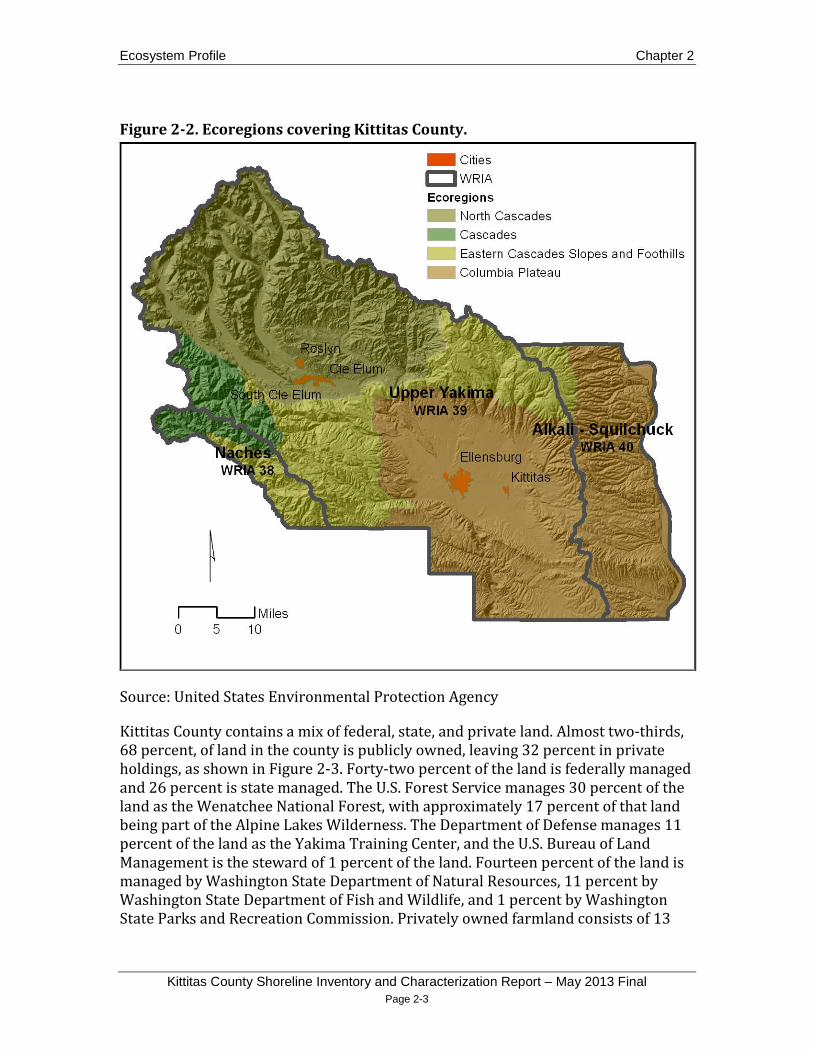
Four different ecoregions are found within Kittitas County: North Cascades, Cascades, Eastern Cascades Slopes and Foothills, and Columbia Plateau (Figure 2-2). The North Cascades ecoregion, found in the northwestern portion of the county, is characterized by glaciated valleys and narrow-crested ridges punctuated by rugged, high relief peaks approaching 8,000 feet above mean sea level (AMSL). It is forested with fir, hemlock, and, in the drier eastern margins, pine. The Cascades ecoregion, located in southwestern Kittitas County, is similar to the North Cascades, but in contrast has more gently undulating terrain, the climate is more temperate, and there is less occurrence of ponderosa pine. The Eastern Cascades Slopes and Foothills ecoregion bisects the central portion of the county. This ecoregion receives less precipitation than the North Cascades and Cascades and has higher temperature extremes. It is forested with open stands of ponderosa pine and some lodgepole pine. To the east of the Eastern Cascades Slopes and Foothills lies semi-arid shrub-steppe and grasslands that are part of the Columbia Plateau ecoregion (EPA 2011). In this region, low-lying land adjacent the Yakima River valley floor has mostly been converted to irrigated agriculture. The Columbia River runs through this ecoregion on the eastern edge of the county. Its banks in the southeast section have the lowest elevation in the county at 475 feet AMSL.

Chapter 2 Ecosystem Profile
Kittitas County Shoreline Inventory and Characterization Report - May 2013 Final Page 2-2
Figure 2-1. Locations of WRIAs in Kittitas County.
Source: Washington State Department of Ecology
Ecosystem Profile Chapter 2
Kittitas County Shoreline Inventory and Characterization Report – May 2013 Final Page 2-3
Figure 2-2. Ecoregions covering Kittitas County.
Source: United States Environmental Protection Agency
Kittitas County contains a mix of federal, state, and private land. Almost two-thirds, 68 percent, of land in the county is publicly owned, leaving 32 percent in private holdings, as shown in Figure 2-3. Forty-two percent of the land is federally managed and 26 percent is state managed. The U.S. Forest Service manages 30 percent of the land as the Wenatchee National Forest, with approximately 17 percent of that land being part of the Alpine Lakes Wilderness. The Department of Defense manages 11 percent of the land as the Yakima Training Center, and the U.S. Bureau of Land Management is the steward of 1 percent of the land. Fourteen percent of the land is managed by Washington State Department of Natural Resources, 11 percent by Washington State Department of Fish and Wildlife, and 1 percent by Washington State Parks and Recreation Commission. Privately owned farmland consists of 13

Chapter 2 Ecosystem Profile
Kittitas County Shoreline Inventory and Characterization Report - May 2013 Final Page 2-4
percent of county area and is primarily devoted to the production of grass hay, cereal grain, and livestock (USDA 2007). Private forestland consists of 1 percent of land area (Cascade Land Conservancy 2009).
Figure 2-3. Public land ownership in Kittitas County.
Source: Washington Department of Natural Resources
Kittitas County has a population density of 17.8 persons per square mile, which is low compared to 101.1 for the State of Washington. The vast majority of Kittitas County’s population of 40,915 (U.S. Census 2010) resides in the Upper Yakima basin (WRIA 39) in and around the five incorporated cities in the county: Ellensburg, Cle Elum, South Cle Elum, Kittitas, and Roslyn. Of these five cities, the largest population center is Ellensburg with 18,174 residents. The city is located adjacent to the Yakima River in the semi-arid Columbia Plateau ecoregion and surrounded by

Ecosystem Profile Chapter 2
Kittitas County Shoreline Inventory and Characterization Report – May 2013 Final Page 2-5
irrigated agriculture. The second largest population center in the county is the conglomeration of Cle Elum, South Cle Elum, and Roslyn, located near the Yakima River and Cle Elum River in the North Cascades ecoregion. These three cities have a combined total of 3,222 residents. In comparison, the Alkali – Squilchuck (WRIA 40) basin has approximately 192 residents, while the Naches basin is unpopulated. (U.S. Census 2010). Figure 2-4 shows population densities in Kittitas County for 2010 based on United States Census blocks.
Figure 2-4. 2010 population density in Kittitas County.
Source: United States Census Bureau

Chapter 2 Ecosystem Profile
Kittitas County Shoreline Inventory and Characterization Report - May 2013 Final Page 2-6
2.1.1 Upper Yakima Basin (WRIA 39) The Upper Yakima basin (WRIA 39) is 2,139 square miles in size, with 1,816 square miles in Kittitas County. The basin lies within all four ecoregions covering Kittitas County and drains into the Yakima River, which flows 214 miles from its headwaters near the Cascade Crest above Keechelus Lake, southeastward to its confluence with the Columbia River, south of the city of Richland in Benton County. The boundary between the Upper and Lower Yakima basins is at the confluence of the Yakima and Naches River, north of the city of Yakima in Yakima County. The Upper Yakima basin in Kittitas County contains 17 subbasins, 7 of which drain into shorelines of the state or shorelines of statewide significance that have confluences with the Yakima River, as shown in Figure 2-5. Three of these subbasins, Lake Cle Elum, Teanaway River, and Swauk Creek, are almost all entirely contained within the North Cascades ecoregion and have streams with confined channels. Taneum Creek is almost entirely located in the Eastern Cascades Slopes and Foothills ecoregion. Manastash Creek, Wilson - Naneum, and Kittitas subbasins have confined channels at their headwaters in the Eastern Cascades Slopes and Foothills ecoregion, which then empty out onto low-gradient alluvial fans in the Columbia Plateau ecoregion before reaching their confluence with the Yakima River.
There are three large glacially formed lakes near the headwaters of the Yakima River that have been converted to reservoirs, which regulate the flow of the Yakima River and part of the Cle Elum River. These include Keechelus and Kachess Lakes in the Easton subbasin and Cle Elum Lake in the Lake Cle Elum basin.
2.1.2 Naches Basin (WRIA 38) The Naches basin (WRIA 38) is 1,105 square miles in size and drains into the Naches River, which originates in the crest of the Cascade Mountains as the Little Naches River. The Naches River begins at the confluence of the Little Naches and Bumping Rivers and empties in the Yakima River north of the city of Yakima in Yakima County. The 112 square miles of the Naches basin within Kittitas County drain into the Little Naches River, which is approximately 20 miles long with 14 miles forming a portion of the county’s southwestern border.
2.1.3 Alkali – Squilchuck Basin (WRIA 40) The Alkali – Squilchuck basin (WRIA 40) is 842 square miles in size with 403 square miles in Kittitas County. The basin drains into the Columbia River, which in most of Kittitas County is a reservoir behind Wanapum Dam. The Alkali – Squilchuck basin is almost entirely within the Columbia Plateau ecoregion with the exception of a small portion in the northwest that is part of the Eastern Cascades Slopes and Foothills

Ecosystem Profile Chapter 2
Kittitas County Shoreline Inventory and Characterization Report – May 2013 Final Page 2-7
ecoregion. Upstream of Kittitas County the river has its headwaters on the west slopes of the Rocky Mountain Range and drains portions of British Columbia, Washington, Idaho, and Montana.
Figure 2-5. Subasins of the Upper Yakima Basin.
2.2 Climate, Geology, and Landforms
2.2.1 Climate The climatic conditions of Kittitas County range from alpine near the summit of the Cascade Range, to arid in the lower valleys. The eastern slopes of the Cascade Range lie in a rain shadow from westerly Pacific Ocean storms. In the summer, westerly winds from the Pacific are weak and the rain shadow effect is most pronounced.

Chapter 2 Ecosystem Profile
Kittitas County Shoreline Inventory and Characterization Report - May 2013 Final Page 2-8
Conversely, in winter, the westerly winds are strongest causing moisture to spill over the mountains (Ferguson 1999). Mean annual precipitation ranges from 140 inches near the Cascade Crest to 7 inches near the Columbia River (Table 2-1). Sixty-one to 81 percent of the annual precipitation falls from October to March, both in the alpine and arid regions of the basin. Mountainous areas in the Upper Yakima and Naches basins receive most of their precipitation in the form of snow from November to March, and as rain during the rest of the year. Snowpack is generally retained through late spring with isolated areas of perennial snow fields remaining all year in the mountains (Pearson 1985). Chinook winds (i.e., warm air that descends down the eastern slopes of the Cascades) and rain-on-snow events often cause rapid melting of the snowpack, which can lead to severe soil erosion and stream channel flooding in the valleys (Reclamation 2002).
Table 2-1. Mean-annual precipitation by Upper Yakima River subbasin, 1951-1980. (Source: Rinella et al. 1991.)
Subbasin Mean Annual Precipitation (inches)
Cle Elum 80-140 Easton 40-80 Upper Naches Teanaway River
20-40 Swauk Creek Elk Heights Taneum Creek Manastash Creek Wilson Creek
10-20
Reecer Creek Thorp Umtanum Creek Wenas Creek Burbank Creek Roza Creek
2.2.1.1 Upper Yakima
Near the Cascade Crest, average maximum monthly temperatures at Stampede Pass ranged from 29.1 to 65.2° F. The lowest average monthly minimum temperature was 21.0°F. Average annual precipitation totaled 87.8 inches with an annual average snowfall of 439.3 inches (1944 to 2012 period of record) (Western Regional Climate Center 2012).

Ecosystem Profile Chapter 2
Kittitas County Shoreline Inventory and Characterization Report – May 2013 Final Page 2-9
At Cle Elum, average maximum monthly temperatures ranged from 34.8 to 81.4°F. The lowest average monthly minimum temperature was 19.8° F. Average annual precipitation totaled 22.51 inches with an annual average snowfall of 83.3 inches (1899 to 2012 period of record) (Western Regional Climate Center 2012).
At the lowest elevations of the Upper Yakima basin in Ellensburg, average maximum monthly temperatures ranged from 34.2 to 84.0°F. The lowest average monthly minimum temperature was 18.7°F. Average annual precipitation totaled 8.89 inches with an annual average snowfall of 27.4 inches (1899 to 2012 period of record) (Western Regional Climate Center 2012).
2.2.1.2 Naches
The Naches basin within Kittitas County has a climate similar to North Cascades ecoregion areas of the Upper Yakima basin. Higher elevation climate is much like Stampede Pass and lower elevations are similar to Cle Elum.
2.2.1.3 Alkali-Squilchuck
On the southeastern edge of the Alkali-Squilchuck basin, at Trinidad, the average maximum monthly temperatures ranged from 34.9 to 92.1°F. The lowest average monthly minimum temperature was 20.6°F. Average annual precipitation totaled 7.77 inches with an annual average snowfall of 22.8 inches (1902 to 1961 period of record) (Western Regional Climate Center 2012).
Average maximum monthly temperatures at Priest Rapids Dam, roughly 9 miles south of Kittitas County on the eastern edge of the basin, ranged from 40.5 to 91.4°F. The lowest average monthly minimum temperature was 27.1°F. Average annual precipitation totaled 6.99 inches with an annual average snowfall of 5.9 inches (1902 to 1961 period of record) (Western Regional Climate Center 2012).
2.2.2 Geology and Landforms The geology of Kittitas County can be spatially grouped by two broad physiographic regions: the Cascade Mountains and the Columbia Plateau. Figure 2-6 shows the major landforms in Kittitas County. The Cascade Mountains are in the west and northwest portion of the county and contain the upper valley of the Yakima River surrounding Cle Elum. Elevation ranges from 6,000 feet or more in the mountains to 1,900 feet around Cle Elum. The highest point in the county, Mount Daniel, at 7,986 feet, is in this region. The Columbia Plateau is in the eastern portion of the county and contains the lower valley of the Yakima River, which surrounds Ellensburg and is locally referred to as the Kittitas Valley. Kittitas Valley, in the Upper Yakima basin, is at an elevation of approximately 1,600 feet. It is formed by the Wenatchee

Chapter 2 Ecosystem Profile
Kittitas County Shoreline Inventory and Characterization Report - May 2013 Final Page 2-10
Mountains, approximately 5,000 feet in elevation, along its northern edge, and Manastash and Umtanum Ridges paralleling the southern edge, averaging 2,500 to 2,800 feet in elevation.
Figure 2-6. Major landforms in Kittitas County.
The Cascade Mountains, in the western portions of the Upper Yakima and Naches basins, are primarily composed of igneous, sedimentary and metamorphic rocks of varying ages (Reclamation 1979). East of the Cascades, the Columbia Plateau, which contains the eastern portions of the Upper Yakima basin and the entire Alkali-Squilchuck basin, is underlain by flows of the Columbia River Basalt Group, which are interfingered with sandstones, siltstones, and conglomerates of the Ellensburg Formation that are derived from sediment eroded or erupted from the Cascade

Ecosystem Profile Chapter 2
Kittitas County Shoreline Inventory and Characterization Report – May 2013 Final Page 2-11
Range (Kittitas County 2004). Figure 2-7 shows the generalized geologic formations of the region.
Figure 2-7. Generalized Geologic Map of the Wenatchee 1:100,000 quadrangle
Source: Tabor et al.
The Kittitas Valley and the Wenatchee Mountains are a valley and ridge system resulting from the Yakima Fold Belt, as are Manastash and Umtanum Ridges. Regional tectonic stresses created the southeast-trending ridges and valleys, and these stresses are likely still active today (Reidel et al. 1994).
Kittitas Valley is filled with alluvial material derived from the surrounding basalt mountains and glacial deposits. Pleistocene-age glaciers originating in the Upper Yakima basin contributed sediment from their source to the Kittitas Valley. Younger,

Chapter 2 Ecosystem Profile
Kittitas County Shoreline Inventory and Characterization Report - May 2013 Final Page 2-12
post-glacial sediments are derived from the surrounding basalt mountains. The alluvial fans and deposits in the valley are composed of these sediments (Kittitas County 2004).
Along the Columbia River, in the Alkali-Squilchuck basin, basalt forms steep cliffs and talus slopes that extend to the shoreline. The talus is primarily composed of sand-, gravel-, cobble- and boulder-sized basalt resulting from freeze-thaw spalling of cliff faces. Other deposits along the Columbia River shoreline include alluvium, alluvial fans, dune sand, loess, artificial fill, and riprap. The alluvium is composed of clay, silt, sand, and gravel from reworked loess, flood deposits, and other sediment formations. Dune sands consist of deep, well-drained soils along the margins of alluvial floodplains (FERC 2006).
Recharge potential, or the likelihood that water will infiltrate through surface materials into the underlying aquifer system, is dependent on four physical conditions: soil permeability, surficial geologic materials, depth to water, and topography. Yakima River basin aquifers are recharged by infiltration of surface and irrigation water, precipitation, and upward migration of water from deeper aquifers. Recharge zones for basalt aquifers are along ridges and in areas of higher altitude, where basalt is exposed at the surface. Recharge rates are moderate or high, with the most infiltration taking place where interbeds, fractures, and other permeable zones surface. Recharge rates in post-basalt aquifers are considered moderate, except in areas north and northwest of Ellensburg, where the recharge rate is low. Recharge rates in the unconsolidated aquifers are variable. Areas dominated by alluvial deposits have high recharge rates, while areas dominated by aeolian or glacial deposits show moderate to low rates of infiltration (Wyrick et al. 1995).
In Kittitas County, folding and faulting affect the direction of regional groundwater flow, influence hydraulic gradients, and can create flow channels or barriers. Some faults of the Yakima Fold Belt have been identified as hydraulic barriers, while others have proven to be conductive and may connect deep basalt formations with shallower aquifers and surface springs. Folding of this nature increases the frequency of fractures on ridges, enhancing aquifer hydraulic conductivity (Reclamation and Ecology 2011a).
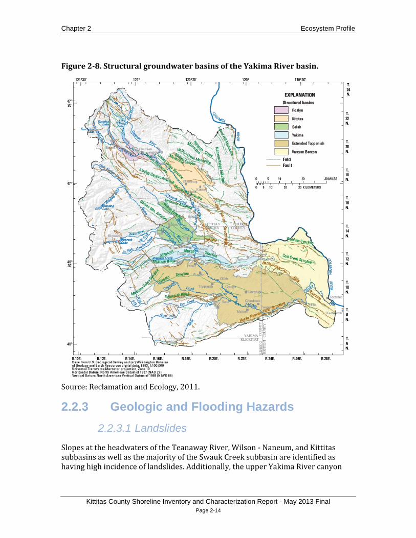
The Roslyn and Kittitas structural groundwater basins are situated in the western portion of the Upper Yakima basin. The Roslyn basin includes the Cle Elum River and reservoir, Keechelus and Kachess reservoirs, the Teanaway River and Swauk Creek, as shown in Figure 2-8 (Reclamation and Ecology 2011a). Covering about 70 square miles, the Roslyn basin is composed of alluvial, lacustrine, glacial, fine-grained lacustrine clay, silt, coarse-grained sand, and gravel deposits. The thickness of the Roslyn basin ranges from zero to 700 feet. The Roslyn basin, as well as the northwestern reaches of the county (including the Naches basin), is situated over older, undefined bedrock.

Ecosystem Profile Chapter 2
Kittitas County Shoreline Inventory and Characterization Report – May 2013 Final Page 2-13
The Kittitas basin includes Taneum, Wilson, Naneum, and Manastash Creeks (Reclamation and Ecology 2011a), in the eastern portion of the Upper Yakima basin. Covering approximately 270 square miles, the Kittitas basin is composed of floodplain alluvial deposits, loess, glacial terrace, Thorp gravel deposits, Ellensburg formation, and undefined continental sedimentary deposits. The thickness of the Kittitas basin ranges from zero to 2,120 feet (Ely et al. 2011). The Kittitas basin, as well as the eastern and southeastern reaches of the county, are situated over the Columbia River Basalt Group (CRBG) and associated interbeds. The thickest underlying hydrogeologic unit of the CRBG is the Grande Ronde basalt, which has been estimated to be as thick as 15,000 feet in the central Yakima River basin (Kahle et al. 2009). The CRGB holds multiple aquifers in various strata and formations, which are collectively called the Columbia Plateau Aquifer System (Reclamation and Ecology 2011a).
Chapter 2 Ecosystem Profile
Kittitas County Shoreline Inventory and Characterization Report - May 2013 Final Page 2-14
Figure 2-8. Structural groundwater basins of the Yakima River basin.
Source: Reclamation and Ecology, 2011.
2.2.3 Geologic and Flooding Hazards 2.2.3.1 Landslides
Slopes at the headwaters of the Teanaway River, Wilson - Naneum, and Kittitas subbasins as well as the majority of the Swauk Creek subbasin are identified as having high incidence of landslides. Additionally, the upper Yakima River canyon

Ecosystem Profile Chapter 2
Kittitas County Shoreline Inventory and Characterization Report – May 2013 Final Page 2-15
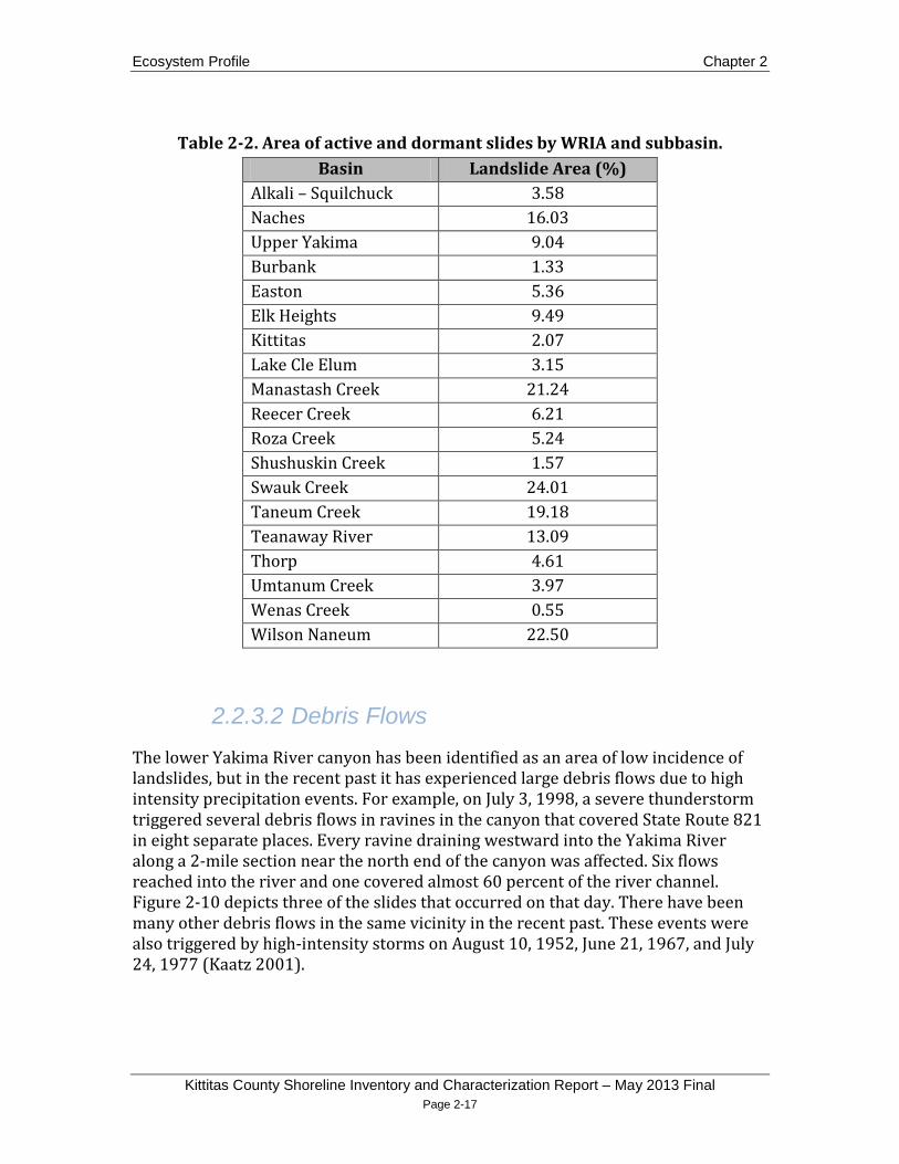
between the confluences of the Teanaway River and Swauk Creek with the Yakima River is also identified as having high incidence of landslides (Godt 2001). Large landslides have occurred in the upper canyon area. For example, in 1970 a landslide destroyed a half-mile section of State Route 10 along the river 7 miles northwest of Ellensburg. A year later a second slide of the same size occurred in the same area without any destruction (Daily Record 2010). The Manastash Creek subbasin is identified as having moderate and high landslide incidence near its headwaters, and high susceptibility but low occurrence throughout the remainder of its confined canyon. The lower portion of the Taneum Creek subbasin, where it is still confined before entering the Yakima River valley, is also identified as having areas of high landslide susceptibility, but low incidence of landslides (Godt 2001). Figure 2-9 shows the locations of known active and dormant landslides in the study area as well classified areas of frequency of incidents and susceptibility. Table 2-2 lists the percentage of area in each WRIA and subbasin of active and dormant landslides.

Chapter 2 Ecosystem Profile
Kittitas County Shoreline Inventory and Characterization Report - May 2013 Final Page 2-16
Figure 2-9. Locations of active and dormant landslides and areas of landslide incidence and susceptibility.
Sources: Washington State Department of Natural Resources and Godt 2001
Ecosystem Profile Chapter 2
Kittitas County Shoreline Inventory and Characterization Report – May 2013 Final Page 2-17
Table 2-2. Area of active and dormant slides by WRIA and subbasin. Basin Landslide Area (%)
Alkali – Squilchuck 3.58 Naches 16.03 Upper Yakima 9.04 Burbank 1.33 Easton 5.36 Elk Heights 9.49 Kittitas 2.07 Lake Cle Elum 3.15 Manastash Creek 21.24 Reecer Creek 6.21 Roza Creek 5.24 Shushuskin Creek 1.57 Swauk Creek 24.01 Taneum Creek 19.18 Teanaway River 13.09 Thorp 4.61 Umtanum Creek 3.97 Wenas Creek 0.55 Wilson Naneum 22.50
2.2.3.2 Debris Flows
The lower Yakima River canyon has been identified as an area of low incidence of landslides, but in the recent past it has experienced large debris flows due to high intensity precipitation events. For example, on July 3, 1998, a severe thunderstorm triggered several debris flows in ravines in the canyon that covered State Route 821 in eight separate places. Every ravine draining westward into the Yakima River along a 2-mile section near the north end of the canyon was affected. Six flows reached into the river and one covered almost 60 percent of the river channel. Figure 2-10 depicts three of the slides that occurred on that day. There have been many other debris flows in the same vicinity in the recent past. These events were also triggered by high-intensity storms on August 10, 1952, June 21, 1967, and July 24, 1977 (Kaatz 2001).

Chapter 2 Ecosystem Profile
Kittitas County Shoreline Inventory and Characterization Report - May 2013 Final Page 2-18
Figure 2-10. July 3, 1998 debris flows in the Yakima River canyon.
Source: Kaatz 2001.
2.2.3.1 Flooding
Flooding is a natural process that is integral to functioning river ecosystems. Floodplains support high levels of biodiversity and primary productivity, provide off-channel refuge habitat for fish, attenuate flood damage, filter surface waters, and allow for groundwater recharge (Opperman et al. 2010).
Despite these benefits, however, flooding can pose a hazard to people and property. The most extensive areas of flood hazard in Kittitas County are located in the unconfined reaches of the Yakima River near the populated areas of Cle Elum and
Ecosystem Profile Chapter 2
Kittitas County Shoreline Inventory and Characterization Report – May 2013 Final Page 2-19
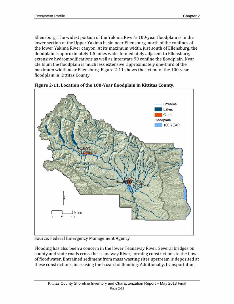
Ellensburg. The widest portion of the Yakima River’s 100-year floodplain is in the lower section of the Upper Yakima basin near Ellensburg, north of the confines of the lower Yakima River canyon. At its maximum width, just south of Ellensburg, the floodplain is approximately 1.5 miles wide. Immediately adjacent to Ellensburg, extensive hydromodifications as well as Interstate 90 confine the floodplain. Near Cle Elum the floodplain is much less extensive, approximately one-third of the maximum width near Ellensburg. Figure 2-11 shows the extent of the 100-year floodplain in Kittitas County.
Figure 2-11. Location of the 100-Year floodplain in Kittitas County.
Source: Federal Emergency Management Agency
Flooding has also been a concern in the lower Teanaway River. Several bridges on county and state roads cross the Teanaway River, forming constrictions to the flow of floodwater. Entrained sediment from mass wasting sites upstream is deposited at these constrictions, increasing the hazard of flooding. Additionally, transportation

Chapter 2 Ecosystem Profile
Kittitas County Shoreline Inventory and Characterization Report - May 2013 Final Page 2-20
infrastructure, bank hardening, and other types of hydromodifications have disconnected the river from portions of the historic floodplain (Molash et al. 2011). Disconnection reduces the ability of the entire system to absorb flood events and increases stream velocity.
Manastash Creek and streams in the Wilson - Naneum and Kittitas subbasins do not have extensive floodplains, but they do cross low-gradient alluvial fans after spilling out of higher gradient canyons. Alluvial fans form where an upland catchment drains into a valley and sufficient sediment material is available to form a fan. Sediment from landslides in the upland is deposited on the fan when it is entrained by high-energy streamflows and carried downstream. The sediment is dropped on the valley floor where the gradient changes and stream energy is reduced, creating a cone-shaped fan with a convex form. Fans often have a single incised channel, but during times of high flow or when sediment or woody debris dams a channel, it can avulse and form a distributary channel, reclaim an abandoned channel, or begin sheet flow across the surface. This results in a radial pattern of active and abandoned channels (NRC 1996). This type of stream pattern can make it difficult to predict where flooding will occur. The slopes in the canyons above these fans are identified as having high incidents of landslides that can provide sediment for transport during high flow such as rain-on-snow events or unusually intense localized rainfall. Rain-on-snow events have caused repeated flooding of Manastash, Naneum, and Wilson Creeks in the past (Daily Record 2011, 1974). Figure 2-12 shows the incised stream channel of Manastash Creek in the background and the braided channels created by avulsions in the foreground during a flood event in May 2011.

Ecosystem Profile Chapter 2
Kittitas County Shoreline Inventory and Characterization Report – May 2013 Final Page 2-21
Figure 2-12. Manastash Creek and channel avulsions on Manastash alluvial fan.
Source: Kittitas County Public Works
2.3 Vegetation and Land Cover Vegetation and land cover in Kittitas County are highly variable. Vegetative cover is influenced primarily by soils, moisture, and temperature, all of which vary topographically. Most of the western portion of the county is forested; near the Cascade Crest, this area also contains permanent snowfields, alpine meadows, and some areas of serpentine soils that support rare plant communities (USGS 2011). As precipitation decreases in an eastward gradient following the rain shadow of the Cascade Mountains, the dominant forest composition shifts from hemlock and fir, to pine species. At lower elevations in the eastern part of the county, shrub-steppe dominates the natural vegetation and irrigated agriculture is abundant on the Yakima River valley floor. Higher elevations within this region retain winter snowpack longer into the spring and are forested, primarily by pine and spruce. Figure 2-13 shows the major ecological systems in Kittitas County.

Chapter 2 Ecosystem Profile
Kittitas County Shoreline Inventory and Characterization Report - May 2013 Final Page 2-22
Figure 2-13. Major ecological systems in Kittitas County.

Ecosystem Profile Chapter 2
Kittitas County Shoreline Inventory and Characterization Report – May 2013 Final Page 2-23
2.3.1 Major Montane Ecological Systems 2.3.1.1 North Pacific Mountain Hemlock Forest
Hemlock forests are found near the Cascade Crest and at high elevations, below subalpine parkland and alpine zones. Tsuga mertensiana (mountain hemlock) and Abies amabilis (Pacific silver fir) are the characteristic dominant tree species (Rocchio and Crawford 2008). These forests are predominantly located in the Upper Yakima basin in the Easton and Lake Cle Elum subbasins (USGS 2011).
2.3.1.2 Northern Rocky Mountain Subalpine Woodland and Parkland
This ecological system is widely distributed at high elevations and forms a mosaic of stunted tree clumps, open woodlands, and herb or dwarf-shrub-dominated openings occurring above closed forest ecosystems and below alpine communities. The system includes open areas with clumps of Pinus albicaulis (whitebark pine) and woodlands dominated by Pinus albicaulis or Larix lyallii (subalpine larch)
2.3.1.3 North Pacific Dry-Mesic Silver Fir-Western Hemlock-Douglas-Fir Forest
, which are found in the Upper Yakima basin in the northern portions of the Easton, Lake Cle Elum, and Teanaway subbasins (Rocchio and Crawford 2008, USGS 2011).
This ecological system also occurs near the Cascade Crest, mainly east of the North Pacific Mountain Hemlock Forests. Here Tsuga heterophylla (western hemlock) and Abies amabilis (Pacific silver fir) or Abies procera (noble fir) dominate the canopy with Pseudotsuga menziesi (Douglas-fir) interspersed (Rocchio and Crawford 2008). These forests are found in the Upper Yakima basin in the Easton, Lake Cle Elum, and western Teanaway River basins as well as the western portion of the Naches basin (USGS 2011).
2.3.1.4 East Cascades Mesic Montane Mixed-Conifer Forest and Woodland
East of the North Pacific Dry-Mesic Silver Fir-Western Hemlock-Douglas-Fir Forest, where precipitation decreases to 40 to 80 inches annually, land cover is dominated by Tsuga heterophylla, Abies grandis (grand fir) and Pseudotsuga menziesii between 2,000 and 4,000 feet. Common shrubs include Mahonia nervosa (dwarf Oregon-grape), Paxistima myrsinites (Oregon boxleaf), Acer circinatum (vine maple), Spiraea betulifolia (white spiraea), Symphoricarpos hesperius (trailing snowberry), Rubus parviflorus (thimbleberry), and Vaccinium membranaceum (thinleaf huckleberry)

Chapter 2 Ecosystem Profile
Kittitas County Shoreline Inventory and Characterization Report - May 2013 Final Page 2-24
(Rocchio and Crawford 2008). These forests are prevalent in the Upper Yakima basin in Easton, Lake Cle Elum, Teanaway River, Taneum Creek, and portions of the Swauk Creek and ElkHeights subbasins as well as throughout most of the Naches basin (USGS 2011).
2.3.1.5 Northern Rocky Mountain Dry Mesic Montane Mixed Conifer Forest
Continuing eastward, vegetative land cover transitions to Pseudotsuga menziesii and Pinus ponderosa (ponderosa pine)
2.3.1.6 Rocky Mountain Subalpine Dry Mesic Spruce Fir Forest and Woodland
with understories of graminoids such as Pseudoroegneria spicata (bluebunch wheatgrass), Calamagrostis rubescens (pinegrass), Carex geyeri (elk sedge), and Carex rossii (Ross’ sedge) (Rocchio and Crawford 2008). These forests are found along a north to south band within the central portion of the Upper Yakima basin in the Teanaway River, Elk Heights, Taneum Creek, Manastash Creek, and Wenas Creek subbasins. They also dominate the northern high elevations of the Swauk Creek, Wilson Naneum, and Kittitas subbasins (USGS 2011).
At elevations above the eastern Pseudotsuga menziesii and Pinus ponderosa forests, Rocky Mountain Subalpine Dry Mesic Spruce Fir Forest and Woodland occur. Tree canopies are dominated by Picea engelmannii (Engelmann spruce) and Abies lasiocarpa (subalpine fir)
2.3.1.7 North Pacific Alpine and Subalpine Dry Grassland
either mixed or alone. Mixed conifer/Populus tremuloides (quaking aspen) stands and Mahonia repens (creeping mahonia) are not uncommon (Rocchio and Crawford 2008). This system is found mainly on ridgetops in the Upper Yakima basin in the northern portions of Lake Cle Elum and Teanaway River subbasins, the western high elevations of the Taneum Creek and Manastash Creek subbasins, and the upper elevations of Wilson -Naneum subbasin as well as the northeastern high elevations of the Naches basin (USGS 2011).
At elevations above the Northern Rocky Mountain Dry Mesic Montane Mixed Conifer Forest and Rocky Mountain Subalpine Dry Mesic Spruce Fir Forest and Woodland forests, North Pacific Alpine and Subalpine Dry Grassland are found. The dominant species is Festuca idahoensis (Idaho fescue), intermixed with forbs (Rocchio and Crawford 2008). These grasslands are limited to small areas at some of the highest elevations supporting vegetation in the Upper Yakima basin in the Easton, Lake Cle

Ecosystem Profile Chapter 2
Kittitas County Shoreline Inventory and Characterization Report – May 2013 Final Page 2-25
Elum, Teanaway River, Taneum Creek, and Manastash Creek subbasins as well as the Naches basin (USGS 2011).
2.3.1.8 Northern Rocky Mountain Ponderosa Pine Woodland and Savanna
These woodlands and savannas occur at the lower treeline/ecotone between grasslands or shrublands at lower elevations and more mesic coniferous forests at higher elevations. Pinus ponderosa is the predominant conifer, though Pseudotsuga menziesii may be present in the tree canopy. The understory can be shrubby, with Artemisia tridentate (big sagebrush), Arctostaphylos uva-ursi (kinnikinnick), Physocarpus malvaceus (mallow ninebark), Purshia tridentate (bitter brush), Symphoricarpos albus (common snowberry), Prunus virginiana (chokecherry), Amelanchier alnifolia (western serviceberry), and Rosa spp. (rose) being common. More open stands support grasses such as Pseudoroegneria spicata, Hesperostipa spp. (needle and thread), Achnatherum spp. (Indian ricegrass),
Ponderosa pine habitat was historically extensive in the inland Northwest. Logging, grazing, invasive species, and fire suppression over the past century have led to the decline of old-growth ponderosa pine forests and their replacement with younger Douglas-fir-dominated forest. Wildlife species such as the white-headed woodpecker and Lewis’ woodpecker depend on and are considered indicator species for healthy ponderosa pine forests (YSFWPB 2004).
or Festuca idahoensis. The more mesic portions of this system may include Calamagrostis rubescens or Carex geyeri (Rocchio and Crawford 2008). These forests are concentrated in a narrow band at elevations just above the shrub-steppe ecotone primarily in the Upper Yakima basin in the Wenas Creek, Manastash Creek, Thorp, Elk Heights, Swauk Creek, Reecer Creek, Wilson - Naneum, and Kittitas subbasins (USGS 2011).
Mixed stands of ponderosa pine-Oregon white oak (Quercus garryana) occur east of the Cascade Mountains, as far north as the Yakama Nation. Oak-dominated woodlands in eastern Washington are more restricted to drier sites transitioning to shrub-steppe or grassland (Johnson and O’Neil 2001).
Oregon white oak is the only native oak species in Washington. Numerous wildlife species are closely associated with oak habitats, such as woodpeckers, neotropical migrant birds, reptiles, and several oak-obligate invertebrate species. Human activities have led to significant declines in oak habitat over the past century. Major impacts have included fire suppression, urban development, agriculture, cutting of oaks for firewood, and livestock grazing (Larsen and Morgan 1998).

Chapter 2 Ecosystem Profile
Kittitas County Shoreline Inventory and Characterization Report - May 2013 Final Page 2-26
2.3.2 Shrub-Steppe Ecological Systems Shrub-steppe was historically an abundant habitat type, covering over 10 million acres in Washington before the 1800s. With the development of irrigation systems, much of this habitat was converted to agriculture. Approximately 40 percent of the historic shrub-steppe acreage remains today, and this habitat is considered a rare and unique ecosystem. Numerous wildlife species are closely associated with shrub-steppe habitat, such as the Brewer’s sparrow and greater sage grouse (YSFWPB 2004).
The largest remaining areas of shrub-steppe are located on the Yakima Training Center, the Yakama Nation Reservation, the Hanford Nuclear Reservation, and several WDFW-owned properties. Scattered shrub-steppe areas also remain on private land, particularly on steep ridges within ranchland. The diversity of native plants and wildlife in the remaining shrub-steppe habitats is impacted by overgrazing, invasive vegetation, wildfires, and habitat fragmentation (YSFWPB 2004).
Shrub-steppe systems occur as a complex mosaic in eastern Kittitas County, as described below.
2.3.2.1 Columbia Plateau Scabland Shrubland
These open dwarf-shrublands occur on sites with little soil development and extensive areas of exposed rock, gravel, or compacted soil. Total vegetation cover is typically low, generally less than 50 percent, and is dominated by Artemisia rigida (rigid sagebrush) along with other shrub and dwarf-shrub species, particularly Eriogonum spp. (buckwheat) as well as scattered forbs, including species of Allium (onion), Antennaria (pussytoes), Balsamorhiza (balsamroot), Lomatium (desert-parsley), Phlox (phlox), and Sedum(stonecrop) (Rocchio and Crawford 2008).
2.3.2.2 Inter-Mountain Basins Big Sagebrush Shrubland
Big sagebrush shrublands are found in broad basins between mountain ranges, on plains and in foothills between 4,900 and 7,550 feet, and are dominated by Artemisia tridentate (basin big sagebrush). Other common shrubs include Purshia tridentata (antelope bitterbrush), Chrysothamnus viscidiflorus (yellow rabbitbrush), and Symphoricarpos oreophilus (mountain snowberry). Perennial herbaceous cover is typically less than 25 percent. Common graminoid species can include Achnatherum hymenoides, Elymus lanceolatus (thickspike wheatgrass), Festuca idahoensis, Hesperostipa comate, Leymus cinereus (basin wildrye), Poa secunda (Sandberg bluegrass), or Pseudoroegneria spicata (Rocchio and Crawford 2008).

Ecosystem Profile Chapter 2
Kittitas County Shoreline Inventory and Characterization Report – May 2013 Final Page 2-27
2.3.2.3 Inter-Mountain Basins Big Sagebrush Steppe
This system is primarily grassland with scattered shrubs, dominated by perennial grasses and forbs (more than 25 percent cover). Shrubs include Artemisia spp. (sagebrush) and/or Purshia tridentataI (bitterbrush) in an open to moderately dense shrub layer with 25 percent or more total perennial herbaceous cover, distinguishing it from Inter-Mountain Basins Big Sagebrush Shrubland which has more shrubs and less grass (Rocchio and Crawford 2008).
2.3.2.4 Inter-Mountain Basins Montane Sagebrush Steppe
These grassy shrublands are found on mountain foothills and slopes, in areas ranging from deep soils to shallow stony flats and ridgetops. In general, this system shows an affinity for mild topography, fine soils, some source of moisture in the soil or more mesic sites, zones of higher precipitation, and areas of snow accumulation. This is a diverse system composed primarily of Artemisia tridentata ssp. and Vaseyan (mountain big sagebrush), but Purshia tridentata may codominate. Other common shrubs include Symphoricarpos spp., Amelanchier spp., Ericameria nauseosa (rubber rabittbrush), Ribes cereum (wax currant), and Chrysothamnus viscidiflorus. Most stands have over 25 percent perennial herbaceous cover. Varied native bunchgrasses are almost always codominant. Higher in the mountains, wildflowers become abundant (Rocchio and Crawford 2008). This system occurs in small areas in the Upper Yakima basin at high elevations in the north of Naneum - Wilson and Kittitas subbasins as well as the northwest high elevations of the Alkali –Squilchuck basin (USGS 2011).
2.3.2.5 Columbia Plateau Steppe and Grassland
This system is composed of extensive grasslands dominated by perennial bunch grasses and forbs (more than 25 percent cover), sometimes with a sparse (below 10 percent cover) shrub layer. These grasslands are composed of Pseudoroegneria spicata, Festuca idahoensis, often with introduced annual Bromus tectorum
2.3.2.6 Columbia Basin Foothill and Canyon Dry Grassland
(cheatgrass) present (Rocchio and Crawford 2008). This system is more dominant in southeastern Upper Yakima basin in the Kittitas and Burbank subbasins and higher elevations on the western edge of the Alkali-Squilchuck basin (USGS 2011).
This grassland type is found on steep open slopes with rocky or gravelly soils that have patchy, thin, wind-blown surface deposits. The grassland is dominated by

Chapter 2 Ecosystem Profile
Kittitas County Shoreline Inventory and Characterization Report - May 2013 Final Page 2-28
patchy native bunchgrass cover and some forbs. Pseudoroegneria spicata and Festuca idahoensis are common species. Occasional deciduous shrubs include Symphoricarpos spp., Holodiscus discolor (oceanspray), Rhus glabrum (smooth sumac), and Ribes spp. (currant) (Rocchio and Crawford 2008). This system is distributed at mid-elevations in Thorp, Manastash Creek, Sushuskin, Umtanum Creek, Roza Creek, and Kittitas subbasins and the Alkali-Squilchuck basin (USGS 2011).
2.3.3 Riparian Ecological Systems Riparian areas were not historically widespread in this arid region, but they have declined from approximately 2 percent to 0.5 percent of the landscape in the inland Northwest. Riparian areas have been affected by altered stream flow regimes, reduction in beaver populations, overgrazing, and invasive vegetation. Most riparian systems of the Columbia Plateau have been degraded, but some high-quality areas remain (YSFWPB 2004). The mosaic of different riparian habitats is discussed below.
2.3.3.1 Columbia Basin Foothill Riparian Woodland and Shrubland
This system is found primarily in the Eastern Cascades Slopes and Foothills and Columbia Plateau ecoregions in the low-elevation canyons and draws or on floodplains. It is characterized by Populus balsamifera ssp. trichocarpa (black cottonwood), Alnus rhombifolia (white alder), Populus tremuloides (quaking aspen), Betula occidentalis (water birch), and Pinus ponderosa. Important shrubs include Crataegus douglasii (black hawthorn), Philadelphus lewisii (mock orange), Cornus sericea (redosier dogwood), Salix lucida spp. lasiandra (Pacific willow), Rosa nutkana (Nootka rose)
2.3.3.2 North Pacific Montane Riparian Woodland and Shrubland
, Rosa woodsii (Woods’ rose), Amelanchier alnifolia (western serviceberry), Prunus virginiana (choke cherry), and Symphoricarpos albus (Rocchio and Crawford 2008).
At higher elevations on steep streams and narrow floodplains above the foothills, but below the alpine environments, riparian areas are dominated by Pinus contorta var. murrayana (lodgepole pine), Populus balsamifera spp. trichocarpa, Populus tremuloides, Alnus incana ssp. tenuifolia (thinleaf alder), Alnus viridis spp. crispa (green alder), Alnus viridis ssp. sinuata (Sitka alder), Alnus rubra (red alder), Rubus spectabilis (salmonberry), Ribes bracteosum (stink currant), Oplopanax horridus

Ecosystem Profile Chapter 2
Kittitas County Shoreline Inventory and Characterization Report – May 2013 Final Page 2-29
(devilsclub)
2.3.4 Upper Yakima Land Cover
, Acer circinatum, and several Salix (willow) species (Rocchio and Crawford 2008).
The Upper Yakima basin land cover is a mix of forest, shrub-steppe, agriculture, and developed land. Approximately 51 percent of the Upper Yakima basin is forested and 21 percent is regenerating harvested forest. Cultivated crops constitute 6 percent of land cover, and pasture/hay covers an additional 6 percent. Both cover types occur mostly in the Columbia Plateau ecoregion surrounding Ellensburg and in the flat valley bottoms near the city of Cle Elum and in the Teanaway subbasin. Barren rock and ice cover approximately 1 percent of the basin near the Cascade Crest and in the foothills, and open water also constitutes 1 percent coverage.
Natural vegetation in the basin is highly variable. Forest cover is dominated by East Cascades Mesic Montane Mixed Conifer Forest and Woodland in the western portion of the basin (14 percent) and Northern Rocky Mountain Dry Mesic Montane Mixed Conifer Forest in the central basin as well as higher elevations in the east (12 percent). Shrub-steppe and grassland constitute 14 percent. The dominant shrub and grassland systems are intermixed and cover fairly equal areas: Columbia Plateau Steppe and Grassland (4 percent) and Columbia Basin Foothill and Canyon Dry Grassland (3 percent), Inter-Mountain Basins Big Sagebrush Shrubland (3 percent), and Columbia Plateau Scabland Shrubland (2 percent) (USGS 2011). Small stands of Quercus garryana (
Developed areas constitute a small portion of the basin. Medium- and high-intensity development account for 0.07 percent of land area, and low-intensity development covers 1 percent. Areas either in use or zoned for industrial and light-industrial uses constitute 0.2 percent of the basin and are concentrated in and around the cities of Ellensburg, Cle Elum, and Kittitas. As of 2006, impervious surface covered approximately 1.2 percent of the basin, increasing by 0.02 percent since 2001 (MRLC 2011).
Oregon white oak) occur near the Swauk River’s confluence with the Yakima River. Although the species is not a dominant vegetation type in the basin, it is unique because it is the northernmost extent of the species east of the Cascades (Nason 2004).
Current mining in the Upper Yakima basin consists of gravel mining and gold mining, but coal mining was a major land use near Roslyn and Cle Elum from the late 1880s to 1960 (YSFWPB 2004). An extensive network of coal shafts is located belowground near the Yakima and Cle Elum Rivers, and large tailings piles still remain above. Gravel mining has been extensive in the Upper Yakima basin. Numerous abandoned gravel pits are located within the Yakima and Cle Elum River

Chapter 2 Ecosystem Profile
Kittitas County Shoreline Inventory and Characterization Report - May 2013 Final Page 2-30
floodplain. As of 2001, active gravel mining was limited to only a few locations. Figure 2-14 shows the locations of abandoned and active gravel mines in the county.
Figure 2-14. Location for active and abandon gravel pits in the Upper Yakima basin.
Gold mining was significant in the Swauk Creek drainage during the late 1800s. Placer and hardrock mining methods significantly altered the lower portion of the Swauk Creek drainage. Historic placer mining in Swauk Creek, beginning in 1870, altered the channel, substrate, and banks. Methods of mining included sluicing, hydraulicing, and dredging. Streambanks and hillsides were hydrauliced to expose aggregate rock for sluicing, which resulted in filled sediment. Dredging was conducted in Swauk Creek in the 1920s and sporadically up until the1950s. Large tailings and piles of boulders left on the banks still remain (Haring 2001). Gold

Ecosystem Profile Chapter 2
Kittitas County Shoreline Inventory and Characterization Report – May 2013 Final Page 2-31
mining still occurs in the area, but on a much smaller scale (YSFWPB 2004). Most current mining is small-scale suction dredging (Haring 2001).
Recreation is an important land use in the Upper Yakima basin, and includes hunting, fishing, camping, hiking, wildlife viewing, and boating. The forested and shrub-steppe habitats offer hunting for several species during prescribed seasons, including deer, elk, cougar, bear, bighorn sheep, and grouse. The agricultural areas provide hunting for pheasants and quail, while the shrub-steppe offers chukars. The Yakima River from Cle Elum to Roza Dam is a highly regarded catch-and-release trout stream. It is fished from both the streambank and drift boats. There are many designated camping areas on public lands throughout basin, and dispersed camping is prevalent along streambanks in the Lake Cle Elum, Teanaway River, and Manastash Creek subbasins. Boating occurs in many areas of the county. Large power boats utilize the reservoirs near the headwaters of the Yakima River, and both the upper Yakima River canyon above Ellensburg and the lower canyon are popular for rafting and floating. The lower canyon is also a popular wildlife viewing area for bighorn sheep and other species (YSFWPB 2004).
2.3.5 Naches Land Cover The Naches basin is predominantly forested; only 0.05 percent of the basin in Kittitas County is developed and consists almost entirely of forest roads. One percent is exposed bedrock (USGS 2011). Impervious surface covered 0.2 percent of the basin in 2006 and there was no change in area of cover since 2001 (MRLC 2011). Over 72 percent of land cover is evergreen forest and 21 percent is regenerating harvested forest. Similar to the Upper Yakima basin, the forests are dominated by East Cascades Mesic Montane Mixed-Conifer Forest and Woodland (36 percent) and Northern Rocky Mountain Dry Mesic Montane Mixed Conifer Forest (15 percent) (USGS 2011).
2.3.6 Alkali-Squilchuck Land Cover The Alkali-Squilchuck basin is dominated by shrub-steppe. Shrub and grassland constitute 82 percent coverage in the basin. Inter-Mountain Basins Big Sagebrush Steppe dominates with 51 percent coverage. The largest grassland system is Columbia Basin Foothill and Canyon Dry Grassland, which makes up 9 percent of the area. Cultivated cropland and pasture/hay covers 2 percent. Three percent of the basin is open water (USGS 2011).
Approximately 10 percent of the basin is forested by Northern Rocky Mountain Ponderosa Pine Woodland and Savanna (8 percent), Rocky Mountain Subalpine Dry Mesic Spruce Fir Forest and Woodland (1 percent), and Northern Rocky Mountain Dry Mesic Montane Mixed Conifer Forest (1 percent) (USGS 2011).

Chapter 2 Ecosystem Profile
Kittitas County Shoreline Inventory and Characterization Report - May 2013 Final Page 2-32
Developed land consists of 0.4 percent of the basin (USGS 2011). Impervious cover in 2006 was 0.4 percent with no change since 2001 (MRLC 2011). There are no industrial land uses or zoned areas in the basin, with the exception of the Wanapum Dam hydroelectric power generation facility.
Recreational land use is also important in the Alkali-Squilchuck basin. Hunting occurs on public land in the northern portion of the basin. Additionally, swimming, boating, and fishing are popular in the Wanapum Dam reservoir.
2.3.7 Transportation Infrastructure Major highway, rail, and trail infrastructure has been developed in Kittitas County in both the Alkali-Squilchuck and Upper Yakima basins. The majority of the infrastructure is contained in the Upper Yakima basin.
Major east–west transportation routes are provided by Interstate 90, U.S Highway 10, Burlington Northern Santa Fe Railroad, and the John Wayne Heritage Trail. In Kittitas County, Interstate 90 begins at the Columbia River near Vantage, in the Alkali-Squilchuck basin. Farther west, the highway enters the Upper Yakima basin and closely follows the Yakima River. After ascending the east slope of the Cascades, the highway skirts the shores of Keechelus Lake, before leaving the county at Snoqualmie Pass. The former major east–west highway, U.S. Route 10, lies to the north of Interstate 90 and parallels sections of the highway. It connects Ellensburg and Cle Elum, following the Yakima River through the upper Yakima River canyon. Additionally, the Burlington Northern Santa Fe Railroad and the bed of the former Chicago-Milwaukie Railroad, now the John Wayne Heritage Trail, follow the Yakima River before exiting the county near Keechelus Lake. This infrastructure crosses the river multiple times throughout its course in the county. In addition to transportation infrastructure, the construction of revetments, riprap banks, and other hydromodifications have disconnected the river from its floodplains (Vaccaro 2011).
Interstate 82 and U.S. Route 97 provide north–south transportation routes through the county. Interstate 82 intersects with Interstate 90 near Ellensburg. It passes over Manastash and Umtanum Ridges, east of the lower Yakima River canyon. U.S. Route 97 intersects with Interstate 90 near Ellensburg. The highway follows Swauk Creek before leaving the county over Blewett Pass, in the Wenatchee Mountains.
Transportation infrastructure can impact ecological processes by disconnecting streams from their floodplains, restricting channel migration, creating barriers to fish passage, and increasing pollution-generating stormwater runoff. These alterations are discussed in Section 2.7.

Ecosystem Profile Chapter 2
Kittitas County Shoreline Inventory and Characterization Report – May 2013 Final Page 2-33
2.4 Surface Water and Groundwater
2.4.1 Surface Waters 2.4.1.1 Upper Yakima and Naches Basins
The Upper Yakima River basin drains the Yakima River, including its major tributaries, the Kachess, Cle Elum and Teanaway Rivers. Minor tributaries within the basin include Wilson, Manastash, Taneum, Swauk, Cabin, Big, and Little Creeks. The Naches River basin within Kittitas County drains the Little Naches River, which becomes the Naches River at its confluence with Bumping River. Major tributaries to the Naches River are the American, Bumping, Rattlesnake and Tieton Rivers. Minor tributaries to the Naches River occurring in Kittitas County are Pileup, Quartz, Milk and Gold Creeks (Anderson 2008).
Once glacial lakes, storage reservoirs within the Upper Yakima and Naches basins are Lakes Keechelus, Kachess and Cle Elum (Upper Yakima), and Bumping and Rimrock Lakes (Naches, located outside Kittitas County). Table 2-3 outlines the physical characteristics for each reservoir.
Table 2-3. Physical characteristics for Upper Yakima and Naches River basin reservoirs (Period of Record: 1920-1999). (Source: Reclamation 2002)
Reservoir Drainage
Area (mi2)
Depth (ft)
Sept 30 Min Historical
Storage (acre-ft)
Sept 30 Average
Historical Storage (acre-ft)
Sept 30 Max Historical
Storage (acre-ft)
Cle Elum 203.0 Max – 258
Mean - 109
12,900 118,000 359,500
Kachess 63.6 Max - 430 20,100 107,200 227,200
Keechelus 54.7 Max – 310 Mean – 96 4,800 40,500 126,900
Bumping 70.7 Max – 117 Mean - 45 2,400 7,900 24,600
Rimrock 187.0 174* 200 74,500 145,100 * =FERC (1990) did not specify whether this is a maximum or minimum depth.
Because snowmelt accounts for a majority of spring and early summer runoff, the snowpack is often referred to as the “sixth reservoir,” (Anchor QEA and HDR Engineering 2011). Just 30 percent of the total natural average annual runoff can be stored within these reservoirs; therefore, irrigation projects depend heavily on the

Chapter 2 Ecosystem Profile
Kittitas County Shoreline Inventory and Characterization Report - May 2013 Final Page 2-34
timing of spring/summer runoff (from snowmelt and rainfall). In an average year, water demand through June is met by this spring/summer runoff, after which reservoirs, then at peak storage, can be utilized (Reclamation and Ecology 2011a).
Surface waters at the highest reaches of the Naches and Upper Yakima basins flow through valleys carved by glacial activity. As these basins lose elevation, channels become incised as they move through narrow canyons. The valley floors of Ellensburg hold deep alluvial floodplains made up of glacial outwash materials. As the Upper Yakima basin meets the lower basin, the main channel begins to meander atop open floodplains of wind-blown soils and lake-bottom silts originating from the Missoula Floods (Bretz 1969). Pre-irrigation maps illustrate that the channel system in these basins was much more complex than current conditions, and contained innumerable side channels and dense riparian vegetation. Overbank flows were much more common, with floodwaters infiltrating floodplain alluvia and discharging naturally into channels to sustain summer flows (Parker and Story 1916; Kinnison and Sceva 1963).
The Yakima River basin (including the Upper Yakima and Naches subbasins) generates a mean annual unregulated streamflow (adjusted) of about 5,600 cubic feet per second (cfs). If left unregulated, flows in the Upper Yakima and Naches basins would be dominated by snowmelt with peak discharges occurring in May or June and would then decline to groundwater-dominated flows in August or September. These flows would be augmented by late fall precipitation and further snowmelt, with Chinook winds occasionally causing winter high water events (Conley et al. 2009).
Historic hydrologic exchanges between the river and aquifer systems have been altered as surface flows are used to supply irrigation water to croplands, and associated canals and drainage systems receive the groundwater that would have historically discharged into the stream channel. This produces an annual regulated streamflow of about 3,600 cfs (Vaccaro and Sumioka 2009).
Major floods have often dominated the landscape from mid-November through February. Usually resulting from rain-on-snow events, these floods historically have provided the hydraulic energy to intermittently reshape the river channel. Current reservoir management has reduced the frequency and distribution of these “channel-forming” flood events (Reclamation 2002).
The implementation of the management policy termed “flip-flop” has altered the natural hydrology of the Upper Yakima basin. First conceived in 1981, flip-flop refers to the release of all water needed by the Wapato Irrigation Project and the Sunnyside Valley Irrigation District, in Yakima County, from the Upper Yakima reservoirs until September. Concurrently, releases from Rimrock and Bumping reservoirs are curtailed. Then in early September, releases are reversed, and the

Ecosystem Profile Chapter 2
Kittitas County Shoreline Inventory and Characterization Report – May 2013 Final Page 2-35
majority of the needed streamflow is provided by Rimrock and Bumping reservoirs, while flows from the Upper Yakima reservoirs are reduced by as much as 3,000 cfs (Anderson 2008). The purpose of flip-flop is to encourage returning Chinook salmon to spawn at lower river stages in the fall, ensuring that the flows needed to keep redds watered are upheld, while still low enough to protect them during their incubation period (November through March) (LeMoine and Brock 2004).
A similar operation, referred to as “mini flip-flop,” is performed between Keechelus and Kachess Lakes in years of sufficient water supply for similar reasons downstream from Easton and Cle Elum Dams. Irrigation releases from Keechelus Lake are greater than from Kachess Lake from June through August. Then, in September and October, irrigation releases from Keechelus Lake are decreased and correspondingly increased from Kachess Lake (YRBWPU and TCWRA 2001).
Surface water diversion in the Upper Yakima basin is approximately 583,000 acre-feet per year. Operational spill from irrigation canals, field runoff, and canal seepage return a portion of the diversion back to the river. The return flows enter the Yakima River upstream of the head of the lower Yakima River canyon, south of Ellensburg. The diversion of water during the early part of the irrigation season contributes streamflow during the middle and later part of the season. The U.S. Bureau of Reclamation found that about one-half of the total volume of surface water diverted returns to the Yakima River. About one-half of that volume returns to the river the same month that the diversion occurs. The lag time for the remainder of the return flow is generally two months. That portion of flow is derived from water that percolates into shallow groundwater aquifers (YRBWPU and TCWRA 2001).
Keechelus and Kachess Lakes are used in conjunction with the other major reservoirs to provide a portion of the stored water to meet Yakima River demands in the Upper Yakima and Lower Yakima basins. A larger portion of the supply is diverted for irrigation in the Upper Yakima basin above the confluence of the Yakima and Cle Elum Rivers where Kittitas Reclamation District’s (KRD) Easton Diversion Dam is located. Figure 2-15 shows major irrigation diversions between Kachess Lake and Ellensburg (YRBWPU and TCWRA 2001).

Chapter 2 Ecosystem Profile
Kittitas County Shoreline Inventory and Characterization Report - May 2013 Final Page 2-36
Figure 2-15. Major irrigation diversions between Kachess Lake and Ellensburg.

Ecosystem Profile Chapter 2
Kittitas County Shoreline Inventory and Characterization Report – May 2013 Final Page 2-37
The Roza Dam, which is located above the confluence of the Yakima and Naches Rivers at the southern end of the lower Yakima River canyon, diverts water for irrigation used in the Lower Yakima subbasin and for hydroelectric power. It has a passable fish ladder and receives stored water from all three reservoirs located in the Upper Yakima basin (YRBWPU and TCWRA 2001).
2.4.1.2 Alkali-Squilchuck
The main body of water running through the Alkali-Squilchuck basin is the Columbia River. The Columbia River originates in British Columbia, Canada, between the Continental Divide and Selkirk Mountains. Tributaries to the Columbia River are generally snow-fed, and have low winter flows and high spring and summer peaks concurrent with snowmelt, which constitutes 60 percent of the natural runoff to the Columbia River during May, June, and July. Glacier melt also contributes to late summer and early fall flows after the snow has melted and precipitation is low (Ecology 2007).
Storage within the basin is provided by the Wanapum Dam and associated reservoir, Wanapum Lake. See Table 2-4 for a description of estimated physical characteristics of the Wanapum reservoir. Variation in elevation of the reservoir can be as high as 11.5 feet. The greatest fluctuations in reservoir elevation usually occur from mid-October to late November in order to aid salmon spawning downstream of Priest Rapids Dam (Grant PUD 2012).
Table 2-4. Estimated physical characteristics of the Wanapum reservoir. (Source Source: Grant PUD 2003.)
Reservoir Characteristic Estimate Normal max operating elevation (ft) 571.5 Min operating elevation (ft) 560.0 Storage at normal max elevation (acre-ft) 693,600.0 Surface area (acres) 14,680.0
Operation of the Columbia River hydropower system has caused the river’s hydrologic seasonality to flatten, as historically high summer flows have decreased while historically low winter flows have increased, with overall decreasing flow velocities. All flow variability has not been lost, however; discharge variability is still prominent between years and over days as flows are altered to meet demands for hydroelectric power (Ecology 2007).

Chapter 2 Ecosystem Profile
Kittitas County Shoreline Inventory and Characterization Report - May 2013 Final Page 2-38
2.4.2 Groundwater 2.4.2.1 Upper Yakima and Naches Basins
Both the Upper Yakima and the Naches basins have been generally conceptualized as being downwelling at their headwaters, losing surface water to the hyporheic and groundwater systems, and upwelling, or gaining surface water from the hyporheic and groundwater systems, at the terminus of the basin, where sedimentary aquifers “pinch out” (Haring 2001; Reclamation 2002). Groundwater occurs under confined, semiconfined, unconfined, and perched conditions (Vaccaro et al. 2009). Groundwater recharge occurs when basalts are exposed at the ground’s surface to precipitation on the anticlinal ridges. Recharge is relatively dependent on localized conditions, as folding and faulting has divided the Yakima basin into multiple, independent subbasins (Reclamation 2002). Regionally, groundwater recharge occurs along the western margin of the Columbia Plateau where the underlying basalts fuse with sediments and rocks at higher elevations in the Cascade Range (Reclamation and Ecology 2011a). Recharge in the upper reaches of the Yakima and Naches basins is a result of precipitation seepage, while the lower reaches of these basins receive most of their groundwater recharge from irrigation runoff and returns (Vaccaro and Olsen 2007). Based on a coarse-scale analysis, aquifer recharge areas along the mainstem upper Yakima River and the lower reaches of its tributaries have a “high” risk of pollution susceptibility (ESA, 2011). The remainder of the Upper Yakima and Naches Basin watershed within the County has a “moderate” risk.
Vaccaro (2011) found that gains and losses to surface water actually occur over the entirety of these river systems, with groundwater generally flowing parallel to the river. Gains and losses are localized, and are a condition of water table elevation, streambed/water surface elevation, variability in the vertical and lateral extent of the aquifer, contrasts in lithology, and stream channel orientation and complexity. Vertical hydraulic gradient (VHG) measurements can illustrate how water moves between the shallow ground aquifer and the river. Estimates of VHG in the Yakima River basin (including the Naches basin) are generally low, indicating that surface-groundwater exchanges are largely vertical, and flow from ridges to streams and rivers in the valleys (Reclamation and Ecology 2011a; Vaccaro 2011). Larger VHG values represent extremely localized geologic conditions. Both of these basins can be considered groundwater dependent ecosystems (GDE). Here, streamflow is largely supported by groundwater that has seeped into the stream channel, and provides thermal refugia for salmonids during high summer and freezing winter temperatures (Vaccaro 2011).

Ecosystem Profile Chapter 2
Kittitas County Shoreline Inventory and Characterization Report – May 2013 Final Page 2-39
2.4.2.2 Alkali-Squilchuck
The overburden aquifer of the Columbia Plateau readily transmits water, as the aquifers are generally coarse-grained and therefore highly permeable within a few feet of the ground’s surface and become fine-grained and less permeable with depth. Groundwater level contours generally mimic ground surface topography, and water level data suggest that over most of the Columbia Plateau, groundwater flow direction is downward except near discharge areas, which are generally located near rivers and streams (WSEFSEC 2004).
Applied irrigation water and precipitation provide for groundwater recharge. Recharge to deep, confined aquifers is generally less than 1 inch per year, but in irrigated areas can be as much as 10 inches per year. In 2000, Kittitas County withdrew 223,550 acre-feet from the Columbia River basin surface waters for irrigation purposes; however, no groundwater was withdrawn (Ecology 2007). Based on a coarse-scale analysis, aquifer recharge areas along the Columbia River within the County have a “low” risk of pollution susceptibility, although some areas south of Vantage have a “high” risk (ESA, 2011).
2.4.3 Instream Flows 2.4.3.1 Upper Yakima and Naches Basins
Beginning in 1977, water supplies in the Pacific Northwest were becoming increasingly inadequate to meet the needs of water consumers, including those of the Yakima River basin. On October 12, 1977, Washington State filed an adjudication of the Yakima River basin to determine the priority and quantity of existing water rights (Reclamation 2002). Known as the Aquavella adjudication, this process is still ongoing, and has hindered the State’s ability to adopt instream flow requirements into the Washington Administration Code (Beecher, personal communication, 2012). Despite the State’s inability to adopt instream flow requirements for the Yakima basin, the United States Congress adopted Title XII of Public Law 103-434 on October 31, 1994. Title XII established new target flows to be maintained past the Prosser and Sunnyside diversion dams, in the lower Yakima River basin, using criteria based on Total Water Supply Available (TWSA) (Reclamation 2002). See Table 2-5 for an outline of target flows based on TWSA. Releases from storage reservoirs in the Upper Yakima basin need to be adjusted in order to meet downstream target flows (Reclamation 2002).

Chapter 2 Ecosystem Profile
Kittitas County Shoreline Inventory and Characterization Report - May 2013 Final Page 2-40
Table 2-5. Title XII target flows to be maintained past Prosser and Sunnyside diversion dams, based on TWSA. (Source: Reclamation 2002.)
TWSA (million acre-feet) Parker and Prosser Flows
(cfs) Apr-Sept May-Sept June-Sept July-Sept
3.2 2.9
2.65
2.9 2.65 2.4
2.4 2.2 2.0
1.9 1.7 1.5
600 500 400
Less than above TWSA 300
Target flows listed in Table 2-5 are not instantaneous flow requirements, and are subject to fluctuation caused by project operations. For any period exceeding 24 hours, however, flows at the Sunnyside diversion dam cannot be reduced to less than 65 percent of target flows, and flows at the Prosser diversion dam cannot be reduced more than 50 cfs from target flows (Reclamation 2002).
2.4.3.2 Alkali-Squilchuck
Prior to 1980, no instream flows had been set for the Columbia River. In 1980, the Washington Administrative Code adopted a rule which outlined minimum flows for multiple reaches of the Columbia River. These water rights are considered “interruptible” because the right is subject to interruption when forecasted river levels fall below flows outlined by this rule (Ecology 2007). Rights can be interrupted in accordance with two situations:
1) For the first 4,500 cfs of water rights issued following senior water right issuances:
a. If the March 1 forecast for April-September runoff at the Dalles, Oregon is between 60 and 88 million acre-feet (MAF), voluntary water conservation practices will be encouraged.
b. If the March 1 forecast for April-September runoff at the Dalles, Oregon is 60 MAF or less, junior water rights will be curtailed if actual flows fall below the minimum average weekly flows as established by WAC-173-564-040.
2) For any appropriations issued in excess of the first 4,500 cfs of water rights following senior water right issuances:
a. If the March 1 forecast for April-September runoff at the Dalles, Oregon is 88 MAF or less, junior water rights will be curtailed if actual flows fall below the minimum average weekly flows as established by WAC-173-564-040.

Ecosystem Profile Chapter 2
Kittitas County Shoreline Inventory and Characterization Report – May 2013 Final Page 2-41
Often, the March 1 forecast is higher than the benchmarks outlined in this rule, but weekly flows during the summer are lower than the minimum average weekly flows as established by WAC-173-564-040. In this scenario, water rights are not interrupted, despite not meeting minimum average weekly flow requirements (Scott, personal communication, 2012).
See Table 2-6 for minimum instantaneous and minimum average weekly flows at the Wanapum control station. This rule allows for the Director of Ecology to reduce these minimum flows by 25 percent if the director “deems it to be an overriding public interest requirement” to do so. However, outflow from Priest Rapids Dam can never be less than 36,000 acre-feet, and the flow from the Columbia River must produce at least 39.4 MAF per year at The Dalles, Oregon (WAC 173-563-050(1)).
Table 2-6. Minimum instantaneous and minimum average weekly flows at the Wanapum control station. (Source: WAC-173-564-040)
Month Min. Instantaneous Flow
(1,000 cfs) Min. Avg. Weekly Flow
(1,000 cfs) Jan 10 30 Feb 10 30 Mar 10 30
Apr 1-15 20 60 Apr 16-25 30 60 Apr 26-30 50 110
May 50 130 June 1-15 50 110
June 16-30 20 80 Jul 1-15 20 80
Jul 16-31 50 110 Aug 50 95 Sep 20 40
Oct 1-15 20 40 Oct 16-31 20 40
Nov 10 30 Dec 10 30

Chapter 2 Ecosystem Profile
Kittitas County Shoreline Inventory and Characterization Report - May 2013 Final Page 2-42
2.5 Water Quality
2.5.1 Upper Yakima The latest (2008) 303(d) list of impaired waters for WRIA 39 in Kittitas County shows 23 locations with impairments in water temperature; 9 impairments in pH; 4 impairments in dissolved oxygen; 7 impairments in fecal coliform; 2 impairments in dioxin; 2 impairments in PCBs; and 1 impairment in chlordane (Table 2-7). Figure 2-16 shows the area of impairment in the Upper Yakima basin.

Ecosystem Profile Chapter 2
Kittitas County Shoreline Inventory and Characterization Report – May 2013 Final Page 2-43
Table 2-7. 303(d) impaired waters in the Kittitas County portion of WRIA 39. (Source: Ecology 2009d)
Location 303(d)
Impairment Location
303(d) Impairment
Big Creek Temperature Naneum Creek
Temperature Bull Ditch Diversion
pH pH
Cabin Creek Temperature Reecer Creek
Temperature Caribou Creek Temperature Fecal Coliform Cle Elum River Temperature
Robinson Creek pH
Coleman Creek Temperature Fecal Coliform
Cooke Creek Dissolved Oxygen Sorenson Creek Fecal Coliform
Temperature Taneum Creek
Temperature Cooper River Temperature Fecal Coliform Currier Creek Fecal Coliform Dissolved Oxygen
Gale Creek Temperature Thorp Creek Temperature Iron Creek Temperature Turbine Ditch pH
Keechelus Lake Dioxin Umtanum Creek Temperature
PCB West Side Channel
pH Little Creek Temperature Fecal Coliform Log Creek Temperature Williams Creek Temperature
Lookout Creek Temperature Wipple
Wasteway pH
Manastash Creek
Temperature
Yakima River
Temperature Fecal Coliform Dissolved Oxygen
Dissolved Oxygen pH pH Chlordane
Meadow Creek Temperature PCB Swauk Creek Temperature Dioxin

Chapter 2 Ecosystem Profile
Kittitas County Shoreline Inventory and Characterization Report - May 2013 Final Page 2-44
Figure 2-16. Areas of 303(d) list impaired waters in WRIAs 38, 39, and 40.
Source: Department of Ecology
Water quality in the Yakima basin becomes progressively degraded from the headwaters to the terminus (Haring 2001; Reclamation and Ecology 2011a). Causes of elevated temperatures in the Upper Yakima basin include removal of riparian vegetation, modifications in channel morphology, and changes in floodplain connection, hyporheic flows, and energy regimes (Reclamation 2002). Elevated temperatures in the Cle Elum River subbasin have been observed directly above and below Cle Elum Lake. Downstream from the reservoir, higher water temperatures are likely due to dam impoundment and nearby forestry practices, while above the reservoir, elevated temperatures are likely resultant of surface waters flowing through the warm, shallow Tucquala Lake (Lieberman and Grabowski 2007). Temperatures in the Teanaway River subbasin are also elevated, and may be

Ecosystem Profile Chapter 2
Kittitas County Shoreline Inventory and Characterization Report – May 2013 Final Page 2-45
attributed to several sources: reduced riparian shade; increased channel width to depth ratios; streambank instability; and decreased summer instream flows (Creech 2003a).
In a 1987-1991 study by the U.S. Geological Survey, over 110 different organic compounds were observed in the Yakima River basin (Reclamation 2002). Organochlorine pesticides (OCPs) are often associated with agricultural practices, mainly irrigation return flows and subsequent sedimentation (Creech 2003b; Reclamation 2002). Turbidity and total suspended sediment loading in the mainstem Yakima River can also be attributed to snowmelt flowing through small streams in the Cascade Range (Anderson 2008). Sedimentation in the Upper Yakima basin has many sources, including irrigation return flows, erosion of earthen roads and culverts, and streambank instability. Streambank instability is principally caused by high winter flows that remove large sections of the streambank, and removal/disturbance of riparian areas by recreational users (Creech 2003b).
Despite being banned over 30 years ago, OCPs and polychlorinated biphenyls (PCBs) persist in the environment as they bind to soil particles where they were once legally used. Irrigation water flowing through these soils picks up sediments and attached OCPs, and carries them into basin surface waters. In some instances, old reserves of OCPs may still be used in the present day. Erosion from other managed areas, such as orchards or forests controlled for insects, may also introduce OCPs back into the environment. Resuspension of channel-bottom sediments during high flows or other disturbances may also cause the reintroduction of these chemicals into the environment (Creech 2003b). Chlordane in the Upper Yakima River and dioxin in Keechelus Lake are now meeting standards, and should be removed from the 303(d) list during the next assessment phase, if applicable (Johnson et al. 2010).
Drought may cause water quality issues in the following irrigation season. Kittitas County water purveyors observed an increase in the number of timothy hay fields that were plowed and seeded in the 2002 and 2006 irrigation seasons. Drought caused junior water right deliveries to be interrupted in 2001 and 2005, resulting in damage to perennial hay crops and subsequent increased plantings the following year (Satnik and Olsen 2005).
Fecal coliform (FC) contamination is often observed downstream of livestock operations or where faulty septic systems are suspected (Reclamation 2002). From April through October, FC levels in the Wilson Creek subbasin regularly exceeded state water quality standards but were not in violation of these standards for the 2008 303(d) assessment phase in Kittitas County. Known sources of FC contamination in the Wilson Creek subbasin are domestic pets, humans, and livestock or wildlife activity. Human sources include leaking or faulty septic systems, leaking or broken sewer lines, failures at the Kittitas wastewater treatment plant, or
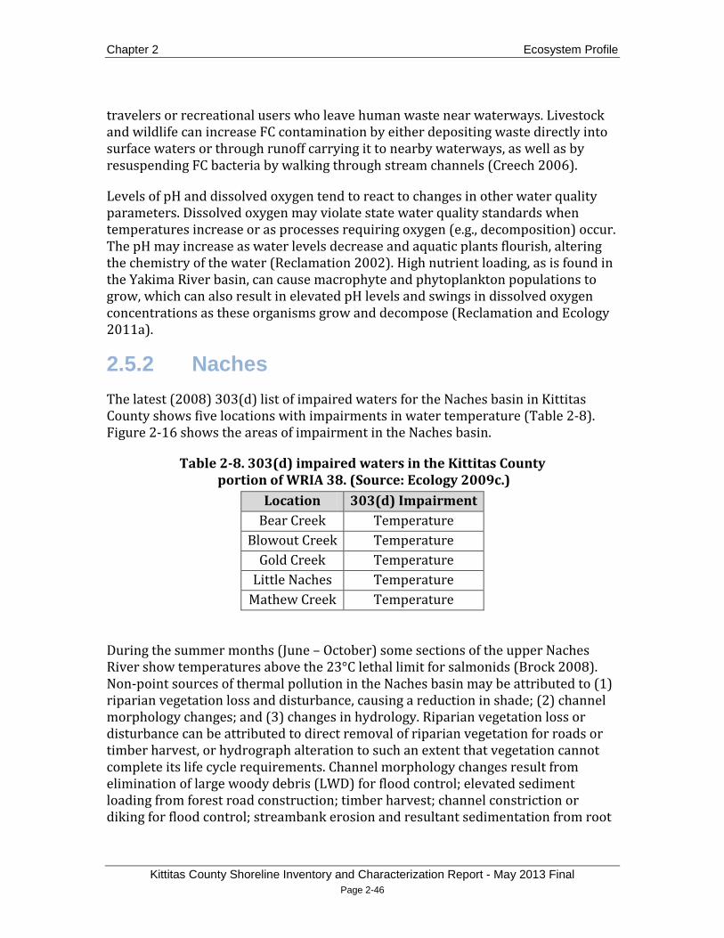
Chapter 2 Ecosystem Profile
Kittitas County Shoreline Inventory and Characterization Report - May 2013 Final Page 2-46
travelers or recreational users who leave human waste near waterways. Livestock and wildlife can increase FC contamination by either depositing waste directly into surface waters or through runoff carrying it to nearby waterways, as well as by resuspending FC bacteria by walking through stream channels (Creech 2006).
Levels of pH and dissolved oxygen tend to react to changes in other water quality parameters. Dissolved oxygen may violate state water quality standards when temperatures increase or as processes requiring oxygen (e.g., decomposition) occur. The pH may increase as water levels decrease and aquatic plants flourish, altering the chemistry of the water (Reclamation 2002). High nutrient loading, as is found in the Yakima River basin, can cause macrophyte and phytoplankton populations to grow, which can also result in elevated pH levels and swings in dissolved oxygen concentrations as these organisms grow and decompose (Reclamation and Ecology 2011a).
2.5.2 Naches The latest (2008) 303(d) list of impaired waters for the Naches basin in Kittitas County shows five locations with impairments in water temperature (Table 2-8). Figure 2-16 shows the areas of impairment in the Naches basin.
Table 2-8. 303(d) impaired waters in the Kittitas County portion of WRIA 38. (Source: Ecology 2009c.)
Location 303(d) Impairment Bear Creek Temperature
Blowout Creek Temperature Gold Creek Temperature
Little Naches Temperature Mathew Creek Temperature
During the summer months (June – October) some sections of the upper Naches River show temperatures above the 23°C lethal limit for salmonids (Brock 2008). Non-point sources of thermal pollution in the Naches basin may be attributed to (1) riparian vegetation loss and disturbance, causing a reduction in shade; (2) channel morphology changes; and (3) changes in hydrology. Riparian vegetation loss or disturbance can be attributed to direct removal of riparian vegetation for roads or timber harvest, or hydrograph alteration to such an extent that vegetation cannot complete its life cycle requirements. Channel morphology changes result from elimination of large woody debris (LWD) for flood control; elevated sediment loading from forest road construction; timber harvest; channel constriction or diking for flood control; streambank erosion and resultant sedimentation from root
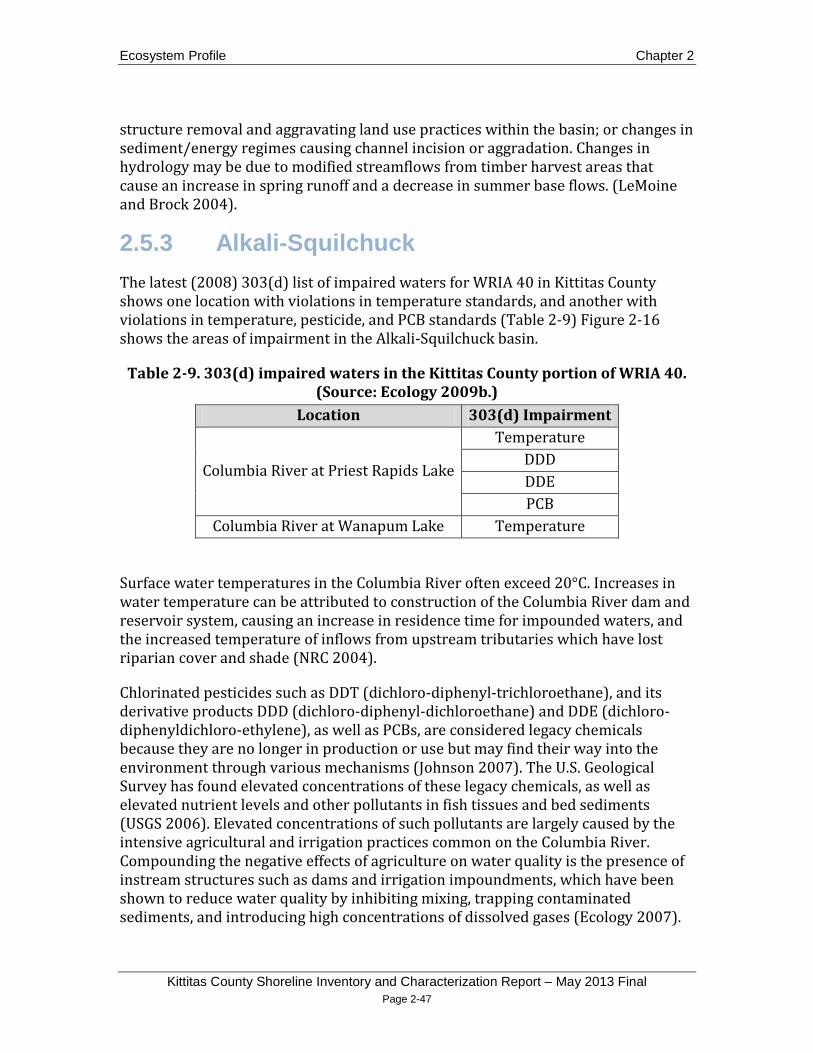
Ecosystem Profile Chapter 2
Kittitas County Shoreline Inventory and Characterization Report – May 2013 Final Page 2-47
structure removal and aggravating land use practices within the basin; or changes in sediment/energy regimes causing channel incision or aggradation. Changes in hydrology may be due to modified streamflows from timber harvest areas that cause an increase in spring runoff and a decrease in summer base flows. (LeMoine and Brock 2004).
2.5.3 Alkali-Squilchuck The latest (2008) 303(d) list of impaired waters for WRIA 40 in Kittitas County shows one location with violations in temperature standards, and another with violations in temperature, pesticide, and PCB standards (Table 2-9) Figure 2-16 shows the areas of impairment in the Alkali-Squilchuck basin.
Table 2-9. 303(d) impaired waters in the Kittitas County portion of WRIA 40. (Source: Ecology 2009b.)
Location 303(d) Impairment
Columbia River at Priest Rapids Lake
Temperature DDD DDE PCB
Columbia River at Wanapum Lake Temperature
Surface water temperatures in the Columbia River often exceed 20°C. Increases in water temperature can be attributed to construction of the Columbia River dam and reservoir system, causing an increase in residence time for impounded waters, and the increased temperature of inflows from upstream tributaries which have lost riparian cover and shade (NRC 2004).
Chlorinated pesticides such as DDT (dichloro-diphenyl-trichloroethane), and its derivative products DDD (dichloro-diphenyl-dichloroethane) and DDE (dichloro-diphenyldichloro-ethylene), as well as PCBs, are considered legacy chemicals because they are no longer in production or use but may find their way into the environment through various mechanisms (Johnson 2007). The U.S. Geological Survey has found elevated concentrations of these legacy chemicals, as well as elevated nutrient levels and other pollutants in fish tissues and bed sediments (USGS 2006). Elevated concentrations of such pollutants are largely caused by the intensive agricultural and irrigation practices common on the Columbia River. Compounding the negative effects of agriculture on water quality is the presence of instream structures such as dams and irrigation impoundments, which have been shown to reduce water quality by inhibiting mixing, trapping contaminated sediments, and introducing high concentrations of dissolved gases (Ecology 2007).

Chapter 2 Ecosystem Profile
Kittitas County Shoreline Inventory and Characterization Report - May 2013 Final Page 2-48
Bioaccumulation of toxic pollutants in fish is also common in the Columbia basin. Aroclors, zinc, aluminum, and DDE were found in the highest concentrations of Columbia Basin fish by the Environmental Protection Agency (EPA 2002), with DDE being the most commonly found pesticide in fish tissue.
Sampling between 2002 and 2004 in the Sand Hollow irrigation basin revealed violations in state water quality standards for several parameters. Sand Hollow, a 60-square-mile irrigation basin, empties into the Columbia River directly across from Vantage, Kittitas County. Ninety-five percent of the basin is irrigated cropland. Within this basin, violations for the following water quality parameters occurred during the time of study: water temperature, dissolved oxygen, and pH. Nitrate levels during the non-irrigation season exceeded the EPA’s Maximum Contaminant Level for potable water. Concentrations of the insecticides azinphos-methyl, chlopyrifos, lindane and the herbicide dinoseb exceeded aquatic-life benchmarks (Wagner et al. 2006).
A 2005 Ecology report concluded that groundwater quality in the Washington State portion of the Columbia plateau is “good.” Where groundwater quality issues did arise, the study attributed the problems to nitrates, metals, pesticides, and other non-point pollution (Ecology 2005). Nitrates have been found in Columbia basin wells that exceed drinking water standards, while pesticides have been shown to persist in nitrate-contaminated wells, occasionally exceeding Maximum Contaminant Level for potable waters (Williamson et al. 1998).
2.6 Fish and Wildlife Species and Habitats
2.6.1 Aquatic Species and Habitats 2.6.1.1 Wetlands and Deep Water Habitats
Wetlands in the Yakima and Columbia River basins occur along major streams and rivers, usually where the water table is at or near the land surface or the surface is covered by shallow water. Wetlands are especially prominent throughout the Kittitas Valley and into the lower Yakima River floodplain. In the Upper Yakima and Naches basins, wetlands are found along smaller tributaries at seeps or springs, at high elevation wet meadows, and along the shorelines of natural lakes (Reclamation 2002; Reclamation and Ecology 2011a). Table 2-10 lists area of wetlands mapped by the National Wetlands Inventory in each basin and subbasin. Long-term irrigation has created new wetlands and altered existing wetlands throughout the region (US Army Corps of Engineers, 2008).

Ecosystem Profile Chapter 2
Kittitas County Shoreline Inventory and Characterization Report – May 2013 Final Page 2-49
Western toads (Bufo boreas), now scarce in their historic range, depend on montane coniferous wetlands for breeding (YSFWPB 2004). Other species common to wetlands are the great blue heron (Ardea herodias), muskrat (Ondatra zibethicus), Canada goose (Branta canadensis)
Table 2-10. Area of wetlands in each basin and subbasin in Kittitas County.
, mallard duck (Anas platyrhynchos), common snipe (Gallinago gallinago), raccoon (Procyon lotor), Cascade frog (Rana cascadae) and Pacific tree frog (Pseudacris regilla) (Reclamation 2002).
Drainage Basin Emergent Wetland
Forested/Shrub Wetland
Total Wetland
acres % of
drainage area
acres % of
drainage area
acres % of
drainage area
Alkali – Squilchuck
129.9 0.05 126.7 0.05 256.6 0.10
Naches 95.6 0.13 304.0 0.42 399.6 0.55 Upper Yakima 5774.9 0.47 6596.8 0.53 12371.7 1.00
Burbank 5.1 0.01 44.6 0.06 49.7 0.07 Easton 415.7 0.25 2358.9 1.40 2774.6 1.65
Elk Heights 138.7 0.33 350.5 0.84 489.2 1.17 Kittitas 1011.5 0.59 100.4 0.06 1111.9 0.65
Lake Cle Elum 460.1 0.32 1435 1.01 1895.1 1.33 Manashtash
Creek 81.6 0.13 177.6 0.29 259.2 0.42
Naches 95.6 0.13 304.0 0.42 399.6 0.55 Reecer Creek 1035.0 1.77 245.4 0.42 1280.4 2.19 Roza Creek 14.4 0.12 38.1 0.32 52.5 0.44
Shushuskin Creek 55.0 0.46 184.2 1.54 239.2 2.00 Swauk Creek 60.6 0.09 144.9 0.21 205.5 0.30
Taneum Creek 29.4 0.06 209.2 0.41 238.6 0.47 Teanaway River 130.2 0.10 245.2 0.18 375.4 0.28
Thorp 92.6 0.33 81.8 0.29 174.4 0.62 Umtanum Creek 0.2 0.00 78.1 0.29 78.3 0.29
Wenas Creek 0.7 0.00 6.2 0.02 6.9 0.02 Wilson Naneum 2148.5 2.51 592.5 0.69 2741.0 3.20
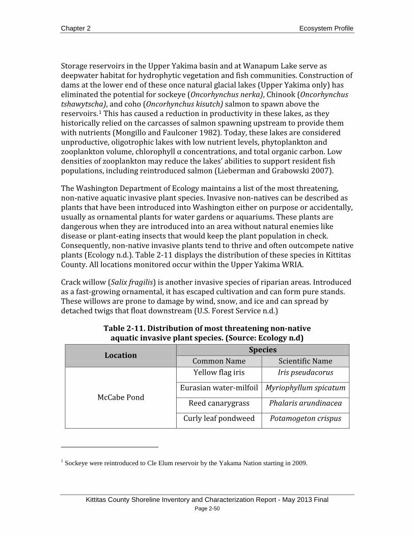
Chapter 2 Ecosystem Profile
Kittitas County Shoreline Inventory and Characterization Report - May 2013 Final Page 2-50
Storage reservoirs in the Upper Yakima basin and at Wanapum Lake serve as deepwater habitat for hydrophytic vegetation and fish communities. Construction of dams at the lower end of these once natural glacial lakes (Upper Yakima only) has eliminated the potential for sockeye (Oncorhynchus nerka), Chinook (Oncorhynchus tshawytscha), and coho (Oncorhynchus kisutch) salmon to spawn above the reservoirs.1
The Washington Department of Ecology maintains a list of the most threatening, non-native aquatic invasive plant species. Invasive non-natives can be described as plants that have been introduced into Washington either on purpose or accidentally, usually as ornamental plants for water gardens or aquariums. These plants are dangerous when they are introduced into an area without natural enemies like disease or plant-eating insects that would keep the plant population in check. Consequently, non-native invasive plants tend to thrive and often outcompete native plants (Ecology n.d.). Table 2-11 displays the distribution of these species in Kittitas County. All locations monitored occur within the Upper Yakima WRIA.
This has caused a reduction in productivity in these lakes, as they historically relied on the carcasses of salmon spawning upstream to provide them with nutrients (Mongillo and Faulconer 1982). Today, these lakes are considered unproductive, oligotrophic lakes with low nutrient levels, phytoplankton and zooplankton volume, chlorophyll α concentrations, and total organic carbon. Low densities of zooplankton may reduce the lakes’ abilities to support resident fish populations, including reintroduced salmon (Lieberman and Grabowski 2007).
Crack willow (Salix fragilis) is another invasive species of riparian areas. Introduced as a fast-growing ornamental, it has escaped cultivation and can form pure stands. These willows are prone to damage by wind, snow, and ice and can spread by detached twigs that float downstream (U.S. Forest Service n.d.)
Table 2-11. Distribution of most threatening non-native aquatic invasive plant species. (Source: Ecology n.d)
Location Species
Common Name Scientific Name
McCabe Pond
Yellow flag iris Iris pseudacorus
Eurasian water-milfoil Myriophyllum spicatum
Reed canarygrass Phalaris arundinacea
Curly leaf pondweed Potamogeton crispus
1 Sockeye were reintroduced to Cle Elum reservoir by the Yakama Nation starting in 2009.

Ecosystem Profile Chapter 2
Kittitas County Shoreline Inventory and Characterization Report – May 2013 Final Page 2-51
Location Species
Common Name Scientific Name
Mattoon Lake
Yellow flag iris Iris pseudacorus
Purple loosestrife Lythrum salicaria
Eurasian water-milfoil Myriophyllum spicatum
Reed canarygrass Phalaris arundinacea
Curly leaf pondweed Potamogeton crispus
Cattail Typha spp.
Beggar-tick Bidens spp.
Freeway Pond
Purple loosestrife Lythrum salicaria
Reed canarygrass Phalaris arundinacea
Curly leaf pondweed Potamogeton crispus
Cattail Typha spp.
Unnamed Pond (17N-19E-02) Purple loosestrife Lythrum salicaria
Eurasian water-milfoil Myriophyllum spicatum
Lavender Lake
Eurasian water-milfoil Myriophyllum spicatum
Reed canarygrass Phalaris arundinacea
Cattail Typha spp.
Wild Duck Lake
Reed canarygrass Phalaris arundinacea
Yellow flag iris Iris pseudacorus
Cattail Typha spp.
Millpond Reed canarygrass Phalaris arundinacea
Cattail Typha spp.
Kiwanis Pond Yellow flag iris Iris pseudacorus
Private Pond (20N-16E-10) Eurasian water-milfoil Myriophyllum spicatum

Chapter 2 Ecosystem Profile
Kittitas County Shoreline Inventory and Characterization Report - May 2013 Final Page 2-52
2.6.1.2 Instream Habitat and Salmon Populations
Historically, the Yakima River basin supported large stocks of anadromous Pacific salmonids, with runs estimated to be as high as 300,000 to 960,000 fish per year in the 1880s (Natural Resources Law Center 1996). Spring and fall Chinook, steelhead (Oncorhynchus mykiss), sockeye, and coho currently inhabit the Upper Yakima basin, while summer Chinook have become locally extinct. However, the Yakama Nation currently has a summer Chinook reintroduction program. In the Kittitas County portion of the Naches basin, spring runs of Chinook are depressed, while fall runs are absent. (Reclamation and Ecology 2011a; WDFW 2008). Spring Chinook spawn and juveniles rear in the Little Naches, Naches, and upper reaches of the Yakima River. Steelhead spawn and juveniles rear in the Naches and Yakima Rivers and their tributaries. Extirpated in the 1980s, coho were reintroduced in the late-1990s and now spawn and rear as juveniles largely in the Wapato and Ellensburg reaches of the Yakima River as well as the lower reaches of the Naches River, below its confluence with the Tieton River. Coho spawning and rearing has also been known to occur in Taneum, Wilson, Reecer, Big and Pileup Creeks, as well as in the North Fork of the Little Naches River (Reclamation and Ecology 2008). Spring, summer, and fall Chinook, steelhead, coho, and sockeye salmon are all present in the Kittitas County portion of the Columbia River basin, while summer steelhead use Tekison, Brushy, Whiskey Dick, and Johnson Creeks for spawning and juvenile rearing (Ecology 2008).
Sockeye salmon were extirpated from the Yakima basin in the early 1900s. In 2009, the Yakama Nation began reintroducing sockeye into Cle Elum reservoir. The sockeye were captured at Priest Rapids Dam on the Columbia River and transported to Cle Elum reservoir. The sockeye have been using the interim fish passage facilities on Cle Elum Dam to migrate downstream.
Past and current management practices are the primary factor to localized extinctions and depressed anadromous Pacific salmonid populations. Storage reservoir management, along with associated active removal of LWD and riparian vegetation, has created low flow conditions in many reaches. Low flows can cause a reduction in fish passage with associated sedimentation impeding spawning success. Instream irrigation diversions can also cause low flows and increased sedimentation. In the upper reaches of the Yakima basin, sedimentation from road construction and other timber harvest practices has also been prevalent (Reclamation and Ecology 2011a).
In the northernmost reaches of the Upper Yakima basin, above the storage reservoirs, there are no constructed barriers. Streams in these upper, forested reaches generally exhibit good habitat conditions, with high-value gravels and gradients well-suited for salmon spawning and rearing. In the Cle Elum subbasin,

Ecosystem Profile Chapter 2
Kittitas County Shoreline Inventory and Characterization Report – May 2013 Final Page 2-53
LWD is abundant and settles in low-gradient, unconfined channel reaches, increasing habitat complexity and channel stability, while lessening bed scour (Reclamation and Ecology 2011a).
2.6.2 Riparian Species and Habitats Riparian areas occur adjacent to flowing water at the ordinary high water mark, and extend into the portion of the terrestrial landscape that is influenced by or directly influences the aquatic ecosystem. The wildlife, vegetation, water tables, soils, and microclimate of terrestrial ecosystems in riparian areas are largely influenced by perennial or intermittent water supplies. At the same time, these factors influence the biological and physical properties of the aquatic ecosystem of the riparian area of which they are a part (WDFW 2008). Intact riparian communities provide food, water, and cover for many wildlife species. Vegetation in the riparian zone provides food and cover for insects emerging from the associated water, as well as resident insect populations. These insects in turn make up the base of the food web for mammals, birds, reptiles, amphibians, and invertebrates that inhabit the riparian area. Because of these important ecological interactions, riparian areas are generally considered to be high-value wildlife habitat.
Approximately 90 percent of Washington’s terrestrial vertebrate species depend on riparian areas to carry out essential life activities (Reclamation 2002). Riparian areas are used for breeding habitat, migration corridors, and seasonal ranges (Ecology 2007; YSFWPB 2004). Examples of wildlife common to riparian areas include Canada goose, mallard duck, wood duck (Aix sponsa), pintail duck (Anas acuta), ruffed grouse (Bonasa umbellus)
Forested riparian areas provide additional habitat resources, such as snags that supply breeding habitat for cavity-nesting mammals and birds, and are a food source for insect-eating birds. Downed trees and dense vegetation provide cover for small mammals and amphibians that require a reliable water source. The high density of prey species makes forested riparian areas especially attractive to foraging reptiles (Kauffman et al. 2001). Larger mammals such as elk (Cervus elaphus) and deer (Odocoileus hemionus and O. virginianus) use forested riparian areas as refuge from high summer temperatures (Knutson and Naef 1997).
, black-capped chickadee (Poecile atricapillus), yellow warbler (Dendroica aestiva), downy woodpecker (Picoides pubescens), beaver (Castor canadensis), raccoon, and Pacific tree frog (Reclamation 2002).
The condition of riparian areas in the Yakima River basin ranges from severely degraded to nearly pristine. The least disturbed riparian habitat is generally found in the forested headwater reaches, becoming progressively more degraded as the river and its tributaries flow through valley floors where agriculture, grazing, and

Chapter 2 Ecosystem Profile
Kittitas County Shoreline Inventory and Characterization Report - May 2013 Final Page 2-54
regulated streamflow become prevalent (Reclamation 2002, Reclamation and Ecology 2011a). In the lower reaches of the Yakima River, large woody debris is often removed to avoid disrupting or damaging irrigation diversion and delivery systems. Low-flow conditions as a result of reservoir management practices cause reduced fish passage, while sedimentation and channelization from logging and road construction impede spawning access (Reclamation and Ecology 2011a).
2.6.3 Terrestrial Species and Habitats 2.6.3.1 Shrub-Steppe and Grassland
Shrub-steppe habitats generally have a lower diversity of wildlife than dry forests due to fewer vegetation layers (Vander Haegen et al. 2001). However, shrub-steppe habitats are still complex and may generally have riparian areas, canyons and diverse topography (WDFW 2008). Higher temperatures and arid conditions shape plant community composition, which in turn influences the presence and distribution of associated wildlife species (Vander Haegen et al. 2001).
Several species depend on shrub-steppe habitat, including striped whipsnake (Masticophis taeniatus), pygmy rabbit (Brachylagus idahoensis), Washington ground squirrel (Urocitellus washingtoni) and sagebrush vole (Lemmiscus curtatus). Some birds are considered sagebrush obligates, including sage thrasher (Oreoscoptes montanus), sage sparrow (Amphispiza belli) and Brewer’s sparrow (Spizella breweri), and both sharp-tailed grouse (Tympanuchus phasianellus) and greater sage grouse (Centrocercus urophasianus) (Dobler et al. 1996). Where larger true steppe or grassland components can be found within shrub-steppe habitats, long-billed curlew (Numenius americanus) and savannah sparrow (Passerculus sandwichensis) are also found (Ecology 2007).
Wildlife species commonly found in but not necessarily confined to shrub-steppe habitat include western skink (Plestiodon skiltonianus), red-tailed hawk (Buteo jamaicensis), northern harrier (Circus cyaneus), common raven (Corvus corax), turkey vulture (Cathartes aura), Great Basin pocket mouse (Perognathus parvus), bushy-tailed woodrat (Neotoma cinerea), Nuttall’s cottontail (Sylvilagus nuttallii), northern pocket gopher (Thomomys talpoides), yellow-bellied marmot (Marmota flaviventris), badger (Taxidea taxus), coyote (Canis latrans), bats, and mule deer (Reclamation 2002).
Shrub-steppe is the principal native habitat type in the Columbia Plateau ecoregion; however, broad conversion to agricultural land has left just 5 percent of the historic coverage in relatively intact condition. Approximately 26 percent of the relatively intact shrub-steppe habitat is dominated by native sagebrush and grasses, with an undisturbed crytopgram crust (thin layer of lichen and moss which suggests an

Ecosystem Profile Chapter 2
Kittitas County Shoreline Inventory and Characterization Report – May 2013 Final Page 2-55
intact community), and containing a largely native shrub and grass understory. Despite disturbances from grazing, off-road vehicles, and other human activities, these shrub-steppe habitats still provide food, cover, and nesting habitat for many wildlife species. Shrub-steppe also provides significant vegetative cover during the winter, when surrounding agricultural fields do not have a cover crop (Reclamation 2002).
Moderately disturbed shrub-steppe habitats showing degradation from non-native plant infestations, grazing, and other disturbances are more common (Reclamation 2002). One of the least disturbed areas of shrub-steppe in Washington State is the Yakima Training Center (YTC) (Dobler et al. 1996). Valley floors near these least-disturbed tracts of shrub-steppe serve as movement corridors for land animals, especially those with large home ranges like deer and elk. The YTC hosts a small population of elk that move northwest from the Arid Lands Ecology Preserve and south from the Quilomene and Colockum Wildlife Areas (Reclamation and Ecology 2011a).
2.6.3.2 Eastside Forests and Woodlands
Eastside mixed coniferous, upland aspen, ponderosa, and lodgepole pine forests occur primarily throughout the eastern Cascades. These forests provide snags for roosting bats (e.g., Myotis species) and cavity-nesting birds such as nuthatches, chickadees, and woodpeckers. Downed wood and multistory vegetation under closed canopies provide cover for breeding salamanders, such as the Larch mountain salamander (Plethodon larselli), songbirds and small mammals, like the yellow-pine chipmunk (Tamias amoenus) and western red-backed vole (Clethrionomys californicus). Regenerating shrub/seedling areas supply important habitat for rodents and reptiles, such as the American pika (Ochotona princeps) or meadow vole (Microtus pennsylvanicus) (Sallabanks et al. 2001).
In 2010, three large canids were observed through multiple remote camera images in the Teanaway subbasin. In June 2011, a lactating adult female canid was captured, and genetic analysis determined the animal was a gray wolf (Canis lupus), a descendent of the Lookout Pack. At the end of 2011, three adults and four pups were observed in the pack, which is considered to have a successful breeding pair (WDFW 2011a).
Forests in the Upper Yakima and Naches basins have been severely degraded due to removal of dead standing trees (snags) and loss of old-growth forest conditions. Fire suppression has created overly dense forest stands, while harvest has removed the largest, oldest trees. Many species, like the white-headed woodpecker (Picoides albolarvatus) and western gray squirrel (Sciurus griseus), depend on mature, cone-bearing evergreens, particularly in the winter months. These species also rely on

Chapter 2 Ecosystem Profile
Kittitas County Shoreline Inventory and Characterization Report - May 2013 Final Page 2-56
downed mature growth for important life stages, such as feeding and nesting (YSFWPB 2004).
Because of current management practices, forest stands east of the Cascades have become vulnerable to bark beetle infestation. Bark beetles, once considered beneficial to coniferous forests, are now seen as pests, as they have destroyed millions of acres of fire-suppressed forests no longer in balance with soil and climate conditions. Besides fire suppression and overstocking, many other factors increase the eastern Cascade forests’ vulnerability to bark beetle infestation: thinning shock, soil compaction, trunk and root injury during logging, infections by root disease and dwarf mistletoe, defoliation by other insect pests, windthrow, fire scorch, snow and ice damage, and poor growing conditions (Halloin 2003).
2.6.3.3 Alpine/Subalpine
Alpine and subalpine habitats can be found in the northernmost reaches of the Upper Yakima basin. Alpine zones are composed of rugged, partially vegetated landscapes with snowfields covering rocky ridges above the treeline. These areas can be characterized by steep terrain, high winds, prolonged snow cover, and intense ultraviolet radiation. Compared to lower elevation habitats, alpine zones are structurally simple, with fewer plant species. Wildlife species in the alpine zone have become adapted to short, intense breeding seasons and seasonal migrations to and from breeding habitat patches and wintering areas. Subalpine parklands are found just below alpine zones, above continuous montane forest (Martin 2001).
Few wildlife species can be considered year-long alpine or subalpine residents. Some examples include the white-tailed ptarmigan (Lagopus leucurus), horned lark (Eremophila alpestris), mountain goat (Oreamnos americanus), bighorn sheep (Ovis Canadensis), American pika, and water voles (Microtus richardsoni). Some species breed across wide elevation gradients, including those found in alpine and subalpine zones. These include Canada geese, long-legged myotis (Myotis volans), white-tailed jackrabbits (Lepus townsendii), yellow-bellied marmots, coyotes, wolverines (Gulo gulo), and mountain lions (Puma concolor) (Martin 2001).
2.6.3.4 Agricultural and Vegetated Urban
The Upper Yakima basin contains large tracts of agricultural land. Pasture, hay, corn and wheat are the dominant uses, with orchards and vineyards at a lesser degree (Reclamation 2002). Livestock grazing has caused a shift in plant community composition from large perennial grasses and other shrub-steppe natives to cheat grass and other invasives (WSEFSEC 2004). However, some low-intensity crops, such as wheat, corn and barely, do provide some benefit for wildlife species, like the western meadowlark (Sturnella neglecta) and horned lark, which have adapted to
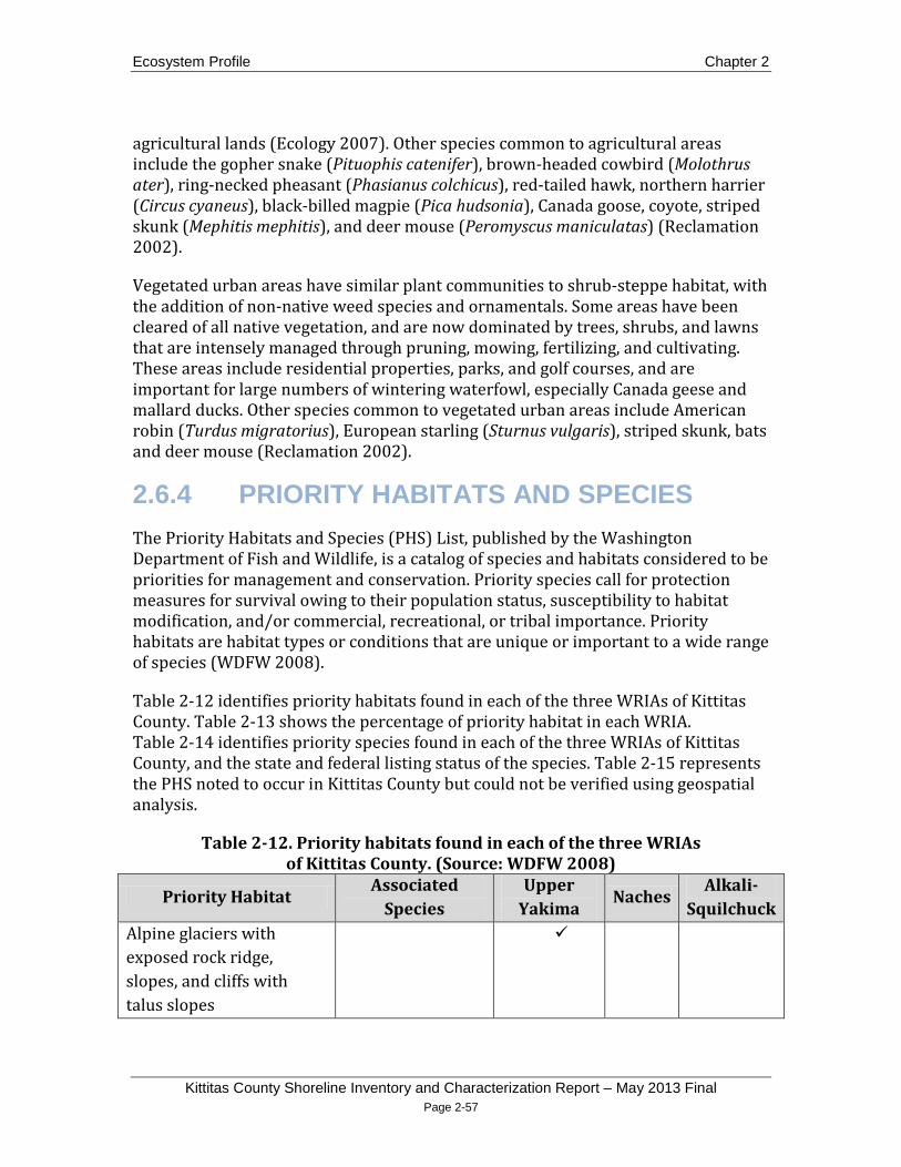
Ecosystem Profile Chapter 2
Kittitas County Shoreline Inventory and Characterization Report – May 2013 Final Page 2-57
agricultural lands (Ecology 2007). Other species common to agricultural areas include the gopher snake (Pituophis catenifer), brown-headed cowbird (Molothrus ater), ring-necked pheasant (Phasianus colchicus), red-tailed hawk, northern harrier (Circus cyaneus), black-billed magpie (Pica hudsonia), Canada goose, coyote, striped skunk (Mephitis mephitis), and deer mouse (Peromyscus maniculatas) (Reclamation 2002).
Vegetated urban areas have similar plant communities to shrub-steppe habitat, with the addition of non-native weed species and ornamentals. Some areas have been cleared of all native vegetation, and are now dominated by trees, shrubs, and lawns that are intensely managed through pruning, mowing, fertilizing, and cultivating. These areas include residential properties, parks, and golf courses, and are important for large numbers of wintering waterfowl, especially Canada geese and mallard ducks. Other species common to vegetated urban areas include American robin (Turdus migratorius), European starling (Sturnus vulgaris), striped skunk, bats and deer mouse (Reclamation 2002).
2.6.4 PRIORITY HABITATS AND SPECIES The Priority Habitats and Species (PHS) List, published by the Washington Department of Fish and Wildlife, is a catalog of species and habitats considered to be priorities for management and conservation. Priority species call for protection measures for survival owing to their population status, susceptibility to habitat modification, and/or commercial, recreational, or tribal importance. Priority habitats are habitat types or conditions that are unique or important to a wide range of species (WDFW 2008).
Table 2-12 identifies priority habitats found in each of the three WRIAs of Kittitas County. Table 2-13 shows the percentage of priority habitat in each WRIA. Table 2-14 identifies priority species found in each of the three WRIAs of Kittitas County, and the state and federal listing status of the species. Table 2-15 represents the PHS noted to occur in Kittitas County but could not be verified using geospatial analysis.
Table 2-12. Priority habitats found in each of the three WRIAs of Kittitas County. (Source: WDFW 2008)
Priority Habitat Associated
Species Upper
Yakima Naches
Alkali-Squilchuck
Alpine glaciers with exposed rock ridge, slopes, and cliffs with talus slopes

Chapter 2 Ecosystem Profile
Kittitas County Shoreline Inventory and Characterization Report - May 2013 Final Page 2-58
Priority Habitat Associated
Species Upper
Yakima Naches
Alkali-Squilchuck
Aspen stands Bald eagle foraging area Bald eagle communal roost
Bald eagle winter roost Biodiversity corridor Sage grouse Breeding site Golden eagle Brushy areas mixed with herbaceous dry vegetation
Bighorn sheep winter range
Bighorn sheep lambing area
Bighorn sheep core area Burrowing owl breeding area
Cliffs – Yakima River Canyon
High raptor concentration
Cliffs – Selah Creek Canyon
Cliffs – Columbia River Canyon
Dusky grouse wintering area
Dusky grouse nesting/brood rearing area
Elk winter range Wenas herd Colockum herd Quilomene herd Elk concentration area Elk calving area Elk feeding area Elk migration corridor Quilomene herd Colockum herd
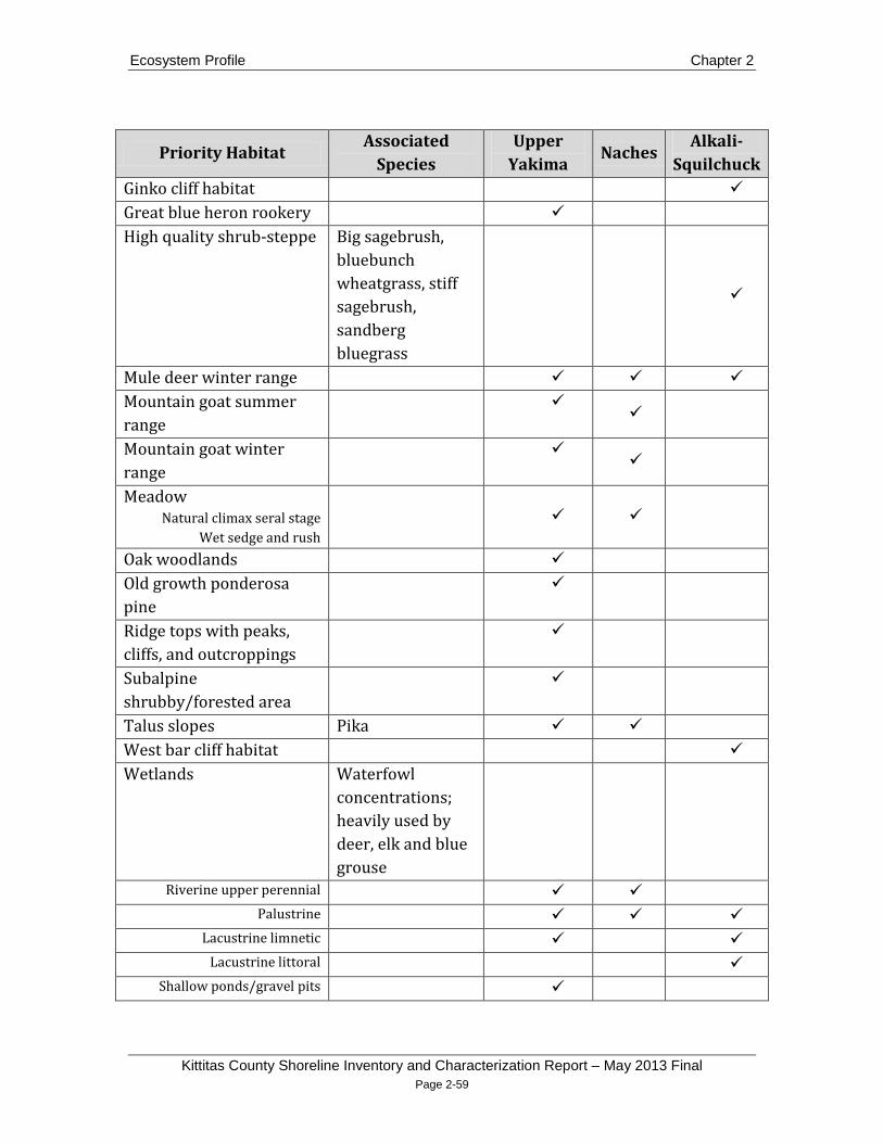
Ecosystem Profile Chapter 2
Kittitas County Shoreline Inventory and Characterization Report – May 2013 Final Page 2-59
Priority Habitat Associated
Species Upper
Yakima Naches
Alkali-Squilchuck
Ginko cliff habitat Great blue heron rookery High quality shrub-steppe Big sagebrush,
bluebunch wheatgrass, stiff sagebrush, sandberg bluegrass
Mule deer winter range Mountain goat summer range
Mountain goat winter range
Meadow Natural climax seral stage
Wet sedge and rush
Oak woodlands Old growth ponderosa pine
Ridge tops with peaks, cliffs, and outcroppings
Subalpine shrubby/forested area
Talus slopes Pika West bar cliff habitat Wetlands Waterfowl
concentrations; heavily used by deer, elk and blue grouse
Riverine upper perennial Palustrine
Lacustrine limnetic Lacustrine littoral
Shallow ponds/gravel pits

Chapter 2 Ecosystem Profile
Kittitas County Shoreline Inventory and Characterization Report - May 2013 Final Page 2-60
Table 2-13. Percentage of priority habitat area in each of the three WRIAs of Kittitas County
Habitat Type Percentage of WRIA (%) WRIA 38 WRIA 39 WRIA 40
Alpine Areas 0.17 0.01 Aspen Stands 0.01
Bald Eagle 0.01 Big Game 0.11
Bighorn Sheep 7.52 7.49 Biodiversity Areas And Corridor 2.91
Chukar 3.89 Cliffs/bluffs 1.53 0.51 0.82
Common Loon 2.86 Dusky Grouse 0.09
Elk 6.18 23.25 73.26 Golden Eagle 0.07 0.03
Harlequin Duck 0.05 Loggerhead Shrike 0.46 0.01 Long-billed Curlew 0.02
Meadows 0.40 Mountain Goat 11.54 7.39
Mule Deer 0.01 17.45 76.67 Northwest White-tailed Deer 0.01
Oak Woodland 0.02 Old-growth/Mature Forest 0.12
Peregrine Falcon 0.03 Rocky Mountain Elk 3.41 2.07
Ruffed Grouse 0.02 Sage Grouse 0.30 1.19
Sagebrush Vole 0.02 Sharptail Snake 0.03
Shrub-steppe 0.79 Talus Slopes 1.49 0.72
Waterfowl Concentrations 2.85 Wetlands 0.05 0.14
Wood Duck 0.02

Ecosystem Profile Chapter 2
Kittitas County Shoreline Inventory and Characterization Report – May 2013 Final Page 2-61
Table 2-14. Priority species found in each of the three WRIAs of Kittitas County. Priority Species Federal Status State Status Upper
Yakima Naches Alkali-Squilchuck
Fish
Coho salmon Threatened (lower Columbia)
Kokanee salmon Sockeye salmon Threatened (Ozette Lake)
Endangered (Snake River)
Candidate *
Bull trout Threatened Candidate* (bull trout only)
Eastern brook trout Mountain whitefish Rainbow trout Spring Chinook Threatened (lower
Columbia) Candidate
Fall Chinook Threatened (lower Columbia)
Candidate
Summer Chinook Threatened (lower Columbia)
Candidate
Summer steelhead Threatened Candidate Westslope cutthroat Brown trout Largemouth bass Smallmouth bass Walleye Sand roller

Chapter 2 Ecosystem Profile
Kittitas County Shoreline Inventory and Characterization Report - May 2013 Final Page 2-62
Priority Species Federal Status State Status Upper Yakima Naches Alkali-
Squilchuck White sturgeon Piute sculpin Monitored Mountain sucker Candidate Pygmy whitefish Spp. of Concern Sensitive Burbot
Amphibians
Cascades frog Monitored Tailed frog Monitored Columbia spotted frog Candidate Western toad Spp. of Concern Candidate Tiger salamander Larch mountain salamander
Spp. of Concern Sensitive
Reptiles
Night snake Monitored Sharptail snake Spp. of Concern Candidate Ringneck snake Monitored Striped whipsnake Candidate Racer Monitored Short-horned lizard Monitored Southern alligator lizard Monitored
Bivalves Western floater Monitored Western pearlshell Monitored
Birds Golden eagle Candidate Bald eagle Spp. of Concern Sensitive Ferruginous hawk Spp. of Concern Threatened Swainson’s hawk Monitored

Ecosystem Profile Chapter 2
Kittitas County Shoreline Inventory and Characterization Report – May 2013 Final Page 2-63
Priority Species Federal Status State Status Upper Yakima Naches Alkali-
Squilchuck Osprey Monitored Merlin American white pelican Endangered Marbled murrelet Threatened Threatened Great blue heron Monitored Common loon Sensitive Foster’s tern Monitored Caspian tern Monitored Rio Grande wild turkey Turkey vulture Monitored Purple martin Loggerhead shrike Spp. of Concern Candidate Long-billed curlew Vaux’s swift Candidate Black swift Spp. of Concern Monitored Western bluebird Monitored Sage sparrow Candidate Sage thrasher Candidate Chukar Dusky grouse Ruffed grouse Sharp-tailed grouse Spp. of Concern Threatened Greater sage-grouse Candidate Threatened Mountain quail Spotted owl Threatened Endangered

Chapter 2 Ecosystem Profile
Kittitas County Shoreline Inventory and Characterization Report - May 2013 Final Page 2-64
Priority Species Federal Status State Status Upper Yakima Naches Alkali-
Squilchuck Burrowing owl Spp. of Concern Candidate Great gray owl Monitored Harlequin duck Wood duck Northern goshawk Spp. of Concern Candidate Peregrine falcon Spp. of Concern Sensitive Prairie falcon Monitored White-headed woodpecker Candidate Three-toed woodpecker Monitored Black-backed woodpecker Candidate Lewis’s woodpecker Candidate Pileated woodpecker Candidate
Mammals
Big brown bat California myotis Yuma myotis Fringed myotis Monitored Little brown myotis Long-legged myotis Monitored Western long-eared bat Monitored Western small-footed myotis
Monitored
Townsend’s big-eared bat Spp. of Concern Candidate Canyon bat Monitored Pallid bat Monitored Spotted bat Monitored

Ecosystem Profile Chapter 2
Kittitas County Shoreline Inventory and Characterization Report – May 2013 Final Page 2-65
Priority Species Federal Status State Status Upper Yakima Naches Alkali-
Squilchuck Elk Mountain goat Mule deer Northwest white-tailed deer
Bighorn sheep Gray wolf Endangered Endangered Grizzly bear Threatened Endangered Wolverine Candidate Candidate Lynx Threatened Threatned Marten Fisher Candidate Endangered Black-tailed jackrabbit Candidate White-tailed jackrabbit Candidate Townsend’s ground squirrel
Spp. of Concern
Western gray squirrel Spp. of Concern Threatened Sagebrush vole Pika
*Sockeye were reintroduced to Cle Elum Reservoir by the Yakama Nation starting in 2009.

Chapter 2 Ecosystem Profile
Kittitas County Shoreline Inventory and Characterization Report - May 2013 Final Page 2-66
Table 2-15. Priority species noted to occur in Kittitas County, but could not be verified using geospatial analysis. (Source: WDFW 2012)
Priority Species Federal Status
State Status
Fish
Pacific lamprey Spp. of Concern
River lamprey Spp. of Concern Candidate
Leopard dace Candidate
Umatilla dace Candidate
Birds
Western grebe Candidate
E WA breeding concentrations of grebes, cormorants
Black-crowned night heron
Cavity-nesting ducks: Barrow’s goldeneye, common goldeneye, bufflehead, hooded merganser
Tundra swan
Sooty grouse
E WA breeding occurances of phalaropes, stilts and avocets
Yellow-billed cuckoo Candidate Candidate
Flammulated owl Candidate
Mammals
Merriam’s shrew Candidate
Preble’s shrew Spp. of Concern Candidate
Cascade red fox Candidate
Fisher Candidate Endangered
Invertebrates Juniper hairstreak Candidate
Silver-bordered fritillary Candidate

Ecosystem Profile Chapter 2
Kittitas County Shoreline Inventory and Characterization Report – May 2013 Final Page 2-67
2.7 Summary of Ecosystem Conditions and Management Needs Several organizations have conducted extensive research on ecosystem conditions and management needs in the Yakima River basin as well as the larger Columbia River basin. These include the Washington State Conservation Commission (Haring 2001), Northwest Power and Conservation Council (YSFWPB 2004), Yakima River Basin Watershed Planning Unit and Tri-County Water Resource Agency (YRBWPU and TCWRA 2001), and Yakima Basin Fish and Wildlife Recovery Board (Conley et al. 2009). This section was synthesized from reports published by these organizations, especially Conley et al., and literature cited previously in this chapter. Not all of the management needs and recommendations identified below can be fully addressed through the SMP; effective ecosystem management will require cross-disciplinary collaborative approaches across numerous regulatory and non-regulatory programs.
2.7.1 Upper Yakima Basin Surface waters in Upper and Lower Yakima basin are highly regulated to provide water for irrigated agriculture and hydropower users. The reservoirs in the Upper Yakima basin are part of the Bureau of Reclamation’s Yakima Irrigation Project, which operates in the entire Yakima River basin including 59,000 acres in the Upper Yakima basin. Irrigation has made the Yakima basin one of the most productive agricultural regions in the United States. In addition to the Reclamation system, many smaller irrigators and private landowners divert water from the Yakima River. Irrigation diversion and storage systems are essential to the Yakima basin’s present economy, but they have also significantly impacted the ecosystem (Conley et al. 2009).
Prior to intensive human development by European settlers, alluvial floodplains in the Upper Yakima basin contained complex systems of braids and disconnected side channels, which absorbed peak flows and promoted infiltration of cold water into the underlying gravels. The complex channel system provided large areas of edge habitat for wildlife, and varying water temperatures and stream velocities for all freshwater life stages of salmonids. The areas of underlying gravel, infiltrated with cold water, hosted microbes and invertebrates that provided a food base for the entire ecosystem. As runoff from snowmelt receded through the summer, cool groundwater discharge upwelled from the gravel into the complex channel networks. This upwelling provided clear base flows during times of low flow and high air temperatures, creating areas with temperatures amenable to outmigrating salmon and steelhead smolts and returning adults. In winter, upwelling

Chapter 2 Ecosystem Profile
Kittitas County Shoreline Inventory and Characterization Report - May 2013 Final Page 2-68
groundwater prevented freezing and provided oxygenated water for incubating eggs and young fish (Ring and Watson 1999).
Currently, floodplain isolation, channel simplification, and the flip-flop regime have dramatically altered river-floodplain interactions and degraded the aquatic environment (Ring and Watson 1999). Extensive floodplains in the Easton, Cle Elum, and Ellensburg reaches of the Upper Yakima basin have been constricted by roads, railroads, and dikes associated with agriculture, development, and gravel mining (Conley et al. 2009, YSFWPB 2004).
2.7.1.1 Altered Flow Regime
• Restore riparian conditions in the lower reaches of Yakima River tributaries, and off-channel and floodplain habitats of the Yakima River.
• Develop a planting program for black cottonwood.
• Address the negative effects of flip-flop through alteration of reservoir operations.
Altering current flow regimes could greatly increase the quality of shoreline ecosystems in Kittitas County. These needs are difficult to address in the context of the Shoreline Master Program, but are mentioned because these processes limit the success of other restoration efforts. River regulation for irrigation and flood control impound spring snowmelt, substantially increase summer flow, and decrease winter flow in the Yakima River and the lower reaches of its tributaries. However, in some locations, irrigation diversions substantially decrease summer flows. The flip-flop regimes dewater portions of the streambed along the upper Yakima and Cle Elum, which can occur over the short period of one week in early September. These operations result in streamflows across the basin that do not support the life-stage requirements of native salmonids (Stanford et al. 2002) and riparian species such as cottonwoods (Jamieson and Braatne 2001).
Black cottonwood is an important species in the Upper Yakima basin ecosystem. Loss of this species affects shade, input of large woody debris, temperature, channel width to depth ratios, and food sources for salmonids. Cottonwood is dependent on a gradual reduction in the spring snowmelt. A quick drop in spring flows prevents seedlings from establishing root systems before the substrates lose moisture, resulting in death. Also, increased streamflow throughout the spring and summer limits the exposure of suitable substrates for colonization and can lead to the replacement of cottonwood stands by other shrub and grass dominated riparian

Ecosystem Profile Chapter 2
Kittitas County Shoreline Inventory and Characterization Report – May 2013 Final Page 2-69
vegetation such as Elaeagnus umbellata (Russian olive), Salix lucida ssp. lasiandra (Pacific willow), or Phalaris arundinacea
The negative effects of flip-flop could be addressed through alteration of reservoir operations, conservation, additional storage, and other measures. The Bureau of Reclamation, in collaboration with other subbasin resource managers and stakeholders, should work together to develop solutions to modifying the flip-flop regime without severely impacting agricultural production (Conley et al. 2009, YSFWPB 2004).
(reed canarygrass) (Conley et al. 2009).
Additionally, effects of flip-flop and floodplain disconnection on salmonid habitat can be mitigated by restoring riparian conditions in the lower reaches of Yakima River tributaries, and off-channel and floodplain habitats of the Yakima River. Lower Reecer, Currier, Whiskey, Mercer, Wilson, Naneum, Coleman, Cherry, Manashtash, Taneum, Swauk, and Lmumma Creeks and the Teanaway River are all candidates for restoration (Conley et al. 2009). The process has already begun on some creeks such as Reecer and Taneum Creeks.
2.7.1.2 Floodplain Confinement
• Remove floodplain confining structures where land use is compatible with periodic flooding.
• Widen bridges to allow channel migration.
• Replace culverts with bridges to allow channel migration.
• Restore floodplain ecological functioning by placing large woody debris and engineered log jams, bank reshaping, and channel reconstruction.
• Retrofit existing roads with hydrological connectivity zones, which link wetlands, shallow aquifers and other hydrologic features.
Removal of floodplain confining structures such as embankments and other types of hydromodifications in areas with land use that is compatible with periodic inundation can restore river systems to more natural conditions and reduce flood risk. Reintroducing streams to their historic floodplain helps dissipate flood energy by spreading potentially fast moving, high volumes of water over a larger surface area, rather than to the confines of the stream channel. This dissipation of energy will decrease streambank erosion, and consequently, sedimentation and turbidity. Restoring surface water-groundwater interactions helps increase groundwater recharge through the infiltration of floodwaters. More frequent infiltration of surface water to groundwater will lower surface water temperatures through the lateral discharge of colder groundwater into the surface water column. Lower

Chapter 2 Ecosystem Profile
Kittitas County Shoreline Inventory and Characterization Report - May 2013 Final Page 2-70
stream temperatures can help restore historic numbers of temperature-sensitive aquatic species (NPCC 2007). The increased area for storage and conveyance of floodwater gained by removing confining structures can reduce flood risk in nearby areas, where land uses are incompatible with periodic flooding (Opperman et al. 2009).
A recent example, the setback of confining hydromodifications adjacent to Reecer Creek in Ellensburg, in conjunction with revegetation, increasing in-stream habitat complexity through placement of large rocks and LWD, and redesigned channel morphology, will increase the length of available fish habitat by 6,000 feet and add 69 acres of valuable floodplain habitat (NPCC 2007).
Other more localized structures that confine the floodplain are bridges and culverts. Narrow bridges and culverts can restrict stream channels from naturally migrating across the floodplain. Also, they act to constrict the movement of water during high flow events, which can cause flooding upstream and scouring downstream. Widening bridges or replacing culverts with bridges can minimize these effects.
Efforts to reduce confinement through hydromodification setbacks and other infrastructure changes will reduce the effect of the altered flow regime in the Upper Yakima basin and increase effective habitat area. Major areas of confinement created by road and railroad beds including Interstate 90 in the Yakima River, U.S. Route 97 on Swauk Creek, and SR 970 on the Teanaway River. In addition to reduction of confinement, activities to restore floodplain ecological functioning may include placing large woody debris and engineered log jams, bank reshaping, channel reconstruction, and other instream habitat work (Conley et al. 2009; YSFWPB 2004).
2.7.1.3 Impaired Fish Passage
• Eliminate barriers to fish passage such as irrigation diversion dams or culverts through removal, redesign, or retrofitting.
• Use bridges, bottomless culverts, or other approved methods to improve fish passage when designing new or modifying existing road crossings.
Passage barriers have significantly reduced the habitat available to salmonids in the Upper Yakima basin. Cle Elum, Kachess, and Keechelus Dams block upstream movements and allow only limited downstream movements. Cle Elum Dam has inundated or blocked an important component of Yakima River anadromous Pacific salmon habitat (YSFWPB 2004). (Interim fish passage facilities have been added at Cle Elum Dam in recent years.) Impassable dams, dry reaches below dams, unscreened diversions, and siphons have eliminated anadromous fish from portions of many Yakima River tributaries. In most of the Upper Yakima basin, the forested

Ecosystem Profile Chapter 2
Kittitas County Shoreline Inventory and Characterization Report – May 2013 Final Page 2-71
watersheds above the agricultural zone contain very good habitat. The Yakima Tributary Access and Habitat Program, through the Kittitas County Conservation District and other project sponsors, is working to open up many of these areas. Additionally, Roza Dam is a potential bottleneck for outmigrating smolts (Conley et al. 2009). The Roza Dam spillway was modified in 2011, which may have resolved the smolt bottleneck.
A 2011 Fish Passage Inventory report conducted by the Washington State Department of Transportation cited 3,200 stream crossing-structures (i.e., culverts) in fish-bearing streams, with 1,978 of these structures reported as barriers to fish passage (WSDOT 2012). The most common conditions at culverts that impede fish passage are excess drop at culvert outlet; high stream velocity within culvert; inadequate stream depth within culvert; excessive turbulence within culvert; and accumulation of debris at culvert opening (WDFW 1999).
Furthermore, 1,521 WSDOT-owned fish passage barriers cited as needing modification or replacement were reported as having the potential to add more than 200 meters of upstream habitat if the barrier was removed (WSDOT 2012). Culverts can either be completely removed and replaced with bridges or retrofitted in order to enhance fish passage. Where appropriate, culverts are redesigned in a way that simulates natural stream conditions with a bottomless design that acts as a natural stream bed. This is achieved through constructing a culvert that is wider than, and has a similar slope to, the existing stream channel (WSDOT 2012).
2.7.1.4 Irrigation Diversion
• Increase irrigation efficiency to reduce the amount of water diverted from rivers.
• Install screens to block fish from entering irrigation canals.
Irrigation diversions and simplification of natural waterways for conveyance of water have had significant impact on tributaries to the Yakima River. Irrigation diversions have dewatered the lower reaches of Swauk, Taneum, Manastash and Big Creeks and the Teanaway River, creating flow and temperature conditions that reduce juvenile salmonid rearing capacity. Reecer and Wilson Creek systems flows have been increased in summer, and tributaries and side channels have been modified for irrigation water conveyance. Modifications include ditch cleaning, diking, and removal of vegetation (Conley et al. 2009).
Irrigation has detrimental effects on the ecosystem. It delays the recharge of aquifers, which increases the mean temperature of infiltrating water (Ring and Watson 1999). Return flows associated with irrigation use can increase stream
Chapter 2 Ecosystem Profile
Kittitas County Shoreline Inventory and Characterization Report - May 2013 Final Page 2-72
temperatures and transport sediment and contaminants into waterways (Conley et al. 2009).
Diversion structures and the practice of running irrigation ditches across natural streams can divert fish into canals that can kill fish when they enter pump systems or are stranded in irrigation ditches. Although major water diversions on the Yakima River are screened, numerous unscreened diversions exist on tributaries. These are being addressed in conjunction with efforts to remove passage barriers and improve riparian conditions in the lower reaches of tributaries surrounding Ellensburg (Conley et al. 2009).
Increasing irrigation efficiency can reduce the amount of water diverted from rivers, reducing return flows and associated water quality issues. Significant improvements have been made in recent decades by individual irrigators, as well as irrigation companies and districts assisted by programs through the USDA Natural Resources Conservation Service, Kittitas County Conservation District, the US Bureau of Reclamation and other entities. These efforts should be continued and expanded (Conley et al. 2009).
Many ongoing restoration efforts are being conducted to address issues with irrigation diversions. The Teanaway River has been the focus of water conservation projects by Yakima River Basin Water Enhancement Project (YRBWEP), Ecology, and Kittitas County Conservation District. WDFW, the Yakama Nation, and the Kittitas Conservation Trust have been active in Taneum Creek, where the two major passage barriers associated with irrigation diversion have been corrected allowing fish access to the upper reaches of the watershed. Manastash Creek had seven unscreened irrigation water diversions across the large alluvial fan in the lower reaches which blocked fish passage and contributed to dewatering the creek. The Manastash Creek Restoration Project, facilitated by the Kittitas County Conservation District, is working toward screening all irrigation diversions, correcting passage barriers and improving instream flow. The effort has resulted in removal of three fish passage barriers, screens for four of the irrigation diversions and significant water placed in the Trust Water Rights program to benefit instream flow in perpetuity (Anna Lael, personal communication).
2.7.1.5 Floodplain and Upland Watershed Development
• Floodplain and critical upland habitat should be protected through acquisition of land and conservation easements.
• Reduce impervious surface.

Ecosystem Profile Chapter 2
Kittitas County Shoreline Inventory and Characterization Report – May 2013 Final Page 2-73
• Set back channel confining structures (hydromodifications) and remove bank armoring where land use is compatible with periodic flooding or channel migration.
• Remove unnecessary roads.
Floodplain development has resulted in major alterations in habitat in the Upper Yakima basin through bank armoring, roads, construction of hydromodifications, and increases in impervious surface. Development impairs riparian and aquatic habitat function by reducing connectivity between streams and adjacent riparian areas, floodplains, and uplands, elevating fine sediment yields, reducing large woody debris, reducing vegetative canopy and increasing stream temperatures, limiting salmonid rearing habitat, increasing water temperature fluctuations, and reducing flows in summer because of floodplain storage loss (Conley et al. 2009, YSFWPB 2004).
Development in floodplain areas is regulated by Kittitas County Public Works via the National Flood Insurance Program (NFIP). Certain types of development within floodplain boundaries are currently permissible given the successful acquisition of a flood development permit. Additionally, flood insurance is available for private landowners residing within a floodplain. Future development in flood hazard areas and floodplains should consider the interconnectedness of stream channels and their adjacent floodplains, as well as the financial impact of floodwaters on manmade structures. These future considerations could include exceeding minimum standards for the elevation of residential and non-residential structures above base flood elevation (Kittitas County 2011). In addition, future floodplain reconnections should be focused in areas most tolerant to inundation. These areas include pastureland, areas where flood-tolerant crops are cultivated, or where annual crops are grown in the dry season (Opperman et al. 2009).
Upland development for commercial, residential, and agricultural use also impacts shoreline ecological function. Increases in impervious area, reduced vegetative cover, roads, and stormwater systems all facilitate rapid runoff of surface water, which increases streamflows and sediment inputs after precipitation events. Rapid runoff reduces groundwater recharge and lowers base flows in streams. Overland flows in developed areas can contaminate groundwater and transport pollutants from upland areas to stream systems (Conley et al. 2009). These pollutants may include heavy metals, pesticides, and petroleum products.
Predicted population growth in Kittitas County has the potential to impact functioning habitat and reduce restoration opportunities (Conley et al. 2009). Areas that are under development pressure and contain important functioning shoreline habitat include the Teanaway River, Big and Swauk Creek watersheds, the
Chapter 2 Ecosystem Profile
Kittitas County Shoreline Inventory and Characterization Report - May 2013 Final Page 2-74
Ellensburg urban growth area, the Cle Elum and Roslyn area, and the alluvial fans surrounding Ellensburg such as the Manastash fan.
Existing habitat in the Upper Yakima basin should be protected through acquisition of land and conservation easements (YSFWPB 2004). Efforts already underway include the Yakama Nation's Side Channels Project, the Cascade Conservation Partnership and Mountain-to-Sound Greenway Programs, and YRBWEP's acquisition efforts. Habitat restoration should be integrated with these acquisition programs (Conley et al. 2009). Another area identified as a critical piece of habitat and a top priority for preservation is a fairly extensive wet meadow/wetland complex that exists in the lower Teanaway basin near its confluence with the Yakima River (YRBWPU and TCWRA 2001). The Kittitas County Conservation District, WSDOT, and Kittitas County have been active in the early stages of developing plans to mitigate effects of floodplain development in the Teanaway.
2.7.1.6 Recreation Impacts
• Educate recreational users about the techniques for low impact camping near shorelines.
• Educate recreational users about the impacts of off-road vehicle use in riparian and wetland areas.
• Enforce existing recreation regulations that are aimed at protecting ecological functions.
• Restore ecologically degraded recreation areas.
Large numbers of residents recreate along Upper Yakima basin waterways, as well as tourists from throughout the state and nation. Population growth may increase camping, hiking, fishing, and off-road vehicle (ORV) activities, especially on publicly owned lands. Impacts of recreational activities such as dispersed camping and ORV use can be significant in riparian areas. Areas heavily impacted by recreation are the Cle Elum and Teanaway Rivers, and Taneum, Manastash, Swauk, and Naneum Creeks. Relocating campsites and reducing soil compaction at dispersed campsites can improve watershed function. Existing education, enforcement, and restoration and protection initiatives should be maintained or expanded in areas with high recreational use (Conley et al. 2009, YSFWPB 2004).
2.7.1.7 Mining
• Monitor existing gravel pits that have been reconnected to streams for ecological changes and expand the practice if successful.

Ecosystem Profile Chapter 2
Kittitas County Shoreline Inventory and Characterization Report – May 2013 Final Page 2-75
• Develop or enforce regulations that minimize the impact of placer mining on instream and riparian habitat based on the life cycle of fish utilizing the stream.
Floodplain gravel mining has had significant impacts on floodplains throughout the basin, especially along Interstate 90 and the lower reaches of the Cle Elum River. Hydromodification structures are often constructed to protect gravel pits from flood events, constricting the floodplain. Gravel pits are also susceptible to bursting, which can cause avulsion of the river channel. Gravel pits that are reconnected to the main channel through unplanned flood events can act as sediment sinks that increase upstream nick-points and head-cutting while also increasing stream power and erosion downstream. Ponds in abandoned gravel pits can warm adjacent river temperatures and act as reservoirs for bass, catfish, and other introduced species that compete with salmonids. Management of past, current, and future gravel pit operations should strive to minimize these impacts (Yakima River Floodplain Mining Impact Study Team 2004).
The potential of restoring natural floodplain habitats may be limited if a substantial amount of floodplain has been converted to gravel pit ponds. It may be possible in the short term to use these ponds to simulate side channel habitats that are found in a natural, dynamic floodplain. Restoring floodplains to conditions that existed prior to the development of pits may require a substantial amount of time to accomplish by natural sediment transport events. This is especially true for large-volume gravel pits in areas of low bedload transport (Collin 1995).
Efforts to reconnect gravel pits in an ecologically prudent manner to the main channel and provide habitat for anadromous salmonids have occurred near Cle Elum at Hansen Ponds. Monitoring reports related to the Hansen Ponds reconnection are limited, but suggest that the hydrology of the reconnected Hansen Ponds is highly correlated to that of the Yakima River. Juvenile anadromous salmonids were observed utilizing the ponds in this early monitoring study, suggesting that reconnected ponds may serve as suitable habitat for salmonid rearing. Additionally, water quality parameters (i.e., temperature, dissolved oxygen, pH, turbidity and specific conductivity) were compared between the reconnected Hansen Ponds and the disconnected I-90 ponds. All water quality parameters studied were higher at the disconnected I-90 ponds, but this result may be more due to the fact that the disconnected ponds were found to be more biologically active than the more oligotrophic Hansen Ponds (Parrish 2006). Monitoring efforts should continue and should be expanded to other abandoned gravel pits if successful.
Small-scale placer mining is conducted in the Swauk Creek subbasin using suction dredging (Haring 2001). Suction dredge mining can impact fish, invertebrates, riparian habitat, and water quality (Harvey and Lisle 1998).

Chapter 2 Ecosystem Profile
Kittitas County Shoreline Inventory and Characterization Report - May 2013 Final Page 2-76
Suction dredging impacts fish primarily during their reproductive stages. Fish eggs can suffer mortality by being entrained in the suction dredge. Mortality can also occur from predation after passing through the dredge (Griffith and Andrews 1981). In contrast, most juvenile and adult fish can avoid or survive entrainment by the dredge. Tailings piles created by dredging in summer can affect reproduction in fall spawning Chinook and coho salmon. Because the tailings are less stable than the undisturbed streambed during high winter flows, they make poor protective habitat for spawning (Harvey and Lisle 1999). Additionally, suspended sediment that is entrained in the stream from dredging may fill pools that are used by fish as resting areas during migration, or suffocate eggs (Harvey 1986).
Suction dredging destroys invertebrate populations mostly through predation (Thomas 1985). Entrainment in the suction dredge does not result in high levels of invertebrate mortality, but dislodged invertebrates are easily preyed upon by fish. Despite the heavy initial impact on invertebrates, it has been found that recovery of invertebrate populations can occur within 1 to 2 months (Harvey 1986).
Riparian habitat can be severely impacted by dredging outside of the wetted perimeter of the stream or under the edge of streambanks. Tailings deposited outside the areas of the wetted perimeter are less likely to be redistributed during high winter flows. Dredging under streambanks can cause them to collapse, which reduces cover habitat for fish and introduces sediment into streams. Sometimes boulders and large woody debris are removed, and riparian vegetation is cut to create more accessible areas in the streambed. These practices also negatively impact cover habitat. (Harvey and Lisle 1999).
Water quality can be affected in several ways. Fuel used to power the suction dredge motor can spill into the waterway and oil and grease can leak from dredge motors (USFS 2001).
2.7.1.8 Forest Practices
• Remove abandoned roads or decommission unnecessary existing roads.
• Employ best practices to prevent sediment from entering streams from the forest road network.
• Replant clearcuts.
• Allow fires to burn in areas where they do not threaten property / infrastructure.
Past forest harvest practices, road construction and maintenance, and fire suppression have all impacted shoreline ecosystems. A critical element of forest

Ecosystem Profile Chapter 2
Kittitas County Shoreline Inventory and Characterization Report – May 2013 Final Page 2-77
practices that has impacted shoreline ecological functioning is road construction. Road construction has isolated creeks from floodplains, caused riparian damage, increased sediment runoff, and contributed to landslides. Harvesting and fire suppression have created conditions that accelerate runoff, increase landslides and sediment loading, elevate water temperatures, and increase streamflows or flood frequency due to loss of forest cover. Programs are underway to improve habitat conditions on federal, state, and private lands (Conley et al. 2009).
Forest health in the Upper Yakima basin is declining, especially at lower and middle elevations in the Naches, Swauk, Teanaway, and Cle Elum drainages. Fire suppression has increased the density of less fire- and pest-resistant tree species, increasing the likelihood of catastrophic fire or pest outbreaks. Periodic, low-level disturbances are beneficial to forest health, but landscape-scale fires would likely result in increased peak flows, lower summer flows, and increased sediment delivery for several decades, increasing the risk of extinction for salmonids (Conley et al. 2009).
Removal of abandoned or unnecessary forest roads would improve wetland and riparian conditions. The Teanaway Creek subbasin is especially prone to increases in peak flow resulting from changes in watershed condition. Watershed function could be improved by mitigating the impacts of roads located next to salmon-bearing streams and revegetating clearcuts on south-facing slopes (Conley et al. 2009).
2.7.1.9 Invasive Species
• Increase daily catch limits on non-native fish species.
• Employ mechanical, electrical, biological, or chemical means to suppress non-native fish populations.
• Educate the public about vectors for the introduction of non-native aquatic plants to waterbodies.
• Employ mechanical, biological, or chemical means to suppress non-native aquatic vegetation.
Introduction of non-native fish species including brook trout, brown trout, lake trout, bass, catfish, bluegill, sunfish, and crappie has affected bull trout populations through a combination of competition, predation, and hybridization. Brook trout hybrids have been observed in upper Cle Elum River where brook trout are numerous (USFS 2006).

Chapter 2 Ecosystem Profile
Kittitas County Shoreline Inventory and Characterization Report - May 2013 Final Page 2-78
Competition, predation, and hybridization between brook trout and native char should be eliminated or reduced by allowing higher harvest through increased daily limits for sport fishing and active suppression of brook trout through mechanical, electrical, biological, or chemical means (WDFW 2000).
Native aquatic plants provide food and habitat for fish and wildlife, stabilize shorelines and contribute to nutrient cycling. Non-native plants have few controls in their new habitat, which allows them to spread rapidly and destroy native plant and animal habitat.
2.7.1.10 Grazing
• Manage livestock grazing in riparian areas to prevent erosion, protect water quality, and control invasive vegetation.
When not properly managed, grazing practices can compact soil, destabilize streambanks, introduce sediment and wastes to streams, and favor the growth of invasive vegetation. These alterations can lead to increased water temperatures, streambed embeddedness, water pollution, and the loss of cover including pools, woody debris, and overhanging vegetation (USFS 2006, ATTRA 2003). However, several management measures can be used to reduce these impacts, such as rotational grazing, use of alternative water sources for livestock, limited access points to streams, and fencing (ATTRA 2003).
In addition, grazing can be used to control invasive vegetation in riparian areas, when used in combination with other measures such as herbicides or biocontrol. Grazing may be especially useful in inaccessible areas or for large weed infestations. The Weed Control Methods Handbook published by The Nature Conservancy (2001) recommends that landowners develop a grazing plan that addresses the type of livestock and species of weeds to be controlled, the timing and duration of grazing, livestock fencing and movement, and control of weed seed dispersal.
2.7.1.11 Reduction in Beaver Activity
• Encourage the presence of beavers in areas with compatible land use.
• Relocate nuisance beavers to areas with compatible land use.
In the Upper Yakima basin, the abundance and distribution of American beaver (Castor canadensis) have been greatly reduced through floodplain development and historic trapping. Floodplain development prevents opportunities to coexist with beaver due to the inherent risks of flooding that are associated with beaver activity.

Ecosystem Profile Chapter 2
Kittitas County Shoreline Inventory and Characterization Report – May 2013 Final Page 2-79
Beavers influence riparian and wetland habitat quantity and quality, and increase summer base flows. Beaver dam construction increases the number of pools, wide channels, and creates wetland habitat. Beaver ponds support fish including coho and Chinook salmon and also capture sediment, increasing water quality downstream. Without beavers, streams have become disconnected from their floodplains and large woody debris supplies have been diminished. The loss of ecological functions that beavers provide directly diminishes riparian productivity (Lichatowich 1999).
Where beaver presence is compatible with land uses, it should be encouraged. Nuisance dams can be managed to reduce flood risks or beavers can be relocated to more appropriate locations (Conley et al. 2009).
2.7.1.12 Water Quality Improvement
• Reduce stream temperatures though activities that provide more shading.
• Reduce impervious surface.
• Remove abandoned forest roads or decommission unnecessary existing roads.
• Manage livestock in riparian areas.
• Implement best practices in agriculture to reduce runoff and erosion directly into streams.
• Educate pet owners about the benefits of properly collecting, bagging, and disposing of pet feces.
• Educate property owners about the benefits of properly maintained septic systems.
Elevated water temperature is the most common reason for state listing of water quality impairment in the Upper Yakima basin in Kittitas County. Degradation is largely derived from multiple non-point sources such as agricultural and forestry practices as well as urban stormwater runoff. Land management activities, such as forest management, grazing, agriculture, and development, can affect temperature adversely where they damage vegetation adjacent to streams, cause excessive erosion of streambanks, add sediment to streams, reduce instream flow, or return warmed waters to the stream.
Causes of elevated temperatures in the Upper Yakima basin include removal of riparian vegetation, modifications in channel morphology, and changes in floodplain
Chapter 2 Ecosystem Profile
Kittitas County Shoreline Inventory and Characterization Report - May 2013 Final Page 2-80
connection (Reclamation 2002). Many riparian areas have been heavily grazed or logged, reducing regeneration of cottonwood and other riparian species that shade shorelines (Conley et al. 2009). Changes in channel morphology can be caused by sedimentation, which has many sources, including irrigation return flows, erosion of earthen roads and culverts, and streambank instability (Creech 2003b). Changes in floodplain connection have been altered by development of transportation and urban infrastructure. Stormwater runoff from impervious surfaces in these areas can increase stream temperatures.
Levels of pH and dissolved oxygen are also impairment issues in some Upper Yakima basin streams. Dissolved oxygen may violate state water quality standards when temperatures increase or as processes requiring oxygen (e.g., decomposition) occur. The pH may increase as water levels decrease and aquatic plants flourish, altering the chemistry of the water
Impairment by fecal coliform is most prevalent in subbasins with agricultural and human development. Contamination is often caused by livestock operations, faulty septic systems, or domestic pets. Fecal coliform levels in streams can be reduced by keeping livestock away from creeks and implementing best management practices to prevent runoff from agricultural fields. Domestic pet owners should properly collect, bag, and trash feces. Property owners can inspect septic systems to make sure they are maintained and working properly.
Water temperatures can be cooled by shading the waterbody through adding and retaining streamside vegetation. Planting programs for cottonwood would benefit salmonids and the ecosystem as a whole (Conley et al. 2009).
See Section 2.7.1.10 for a discussion of managing livestock grazing in riparian areas.
2.7.1.13 Lake Shorelines
• Educate the public about vectors for the introduction of non-native aquatic plants to waterbodies.
• Educate the public about the techniques for low impact camping on lake shorelines.
• Preserve and protect the remaining intact riparian vegetation within recreation areas.
Lake shorelines in the Upper Yakima basin contain almost no development other than recreation and transportation. Most lakes are located on state and federal lands. The largest lakes in the basin are used for water impoundment. Lake shorelines on public lands may be subject to soil compaction from dispersed
Ecosystem Profile Chapter 2
Kittitas County Shoreline Inventory and Characterization Report – May 2013 Final Page 2-81
camping. The greatest impact to the glacial lakes that have been converted to reservoirs is recreational development, fluctuating shorelines due their current function as storage impoundments, and contamination by stormwater runoff from transportation infrastructure.
Lake shorelines that are repeatedly exposed to drawdown tend to have low abundance and diversity of emergent, submergent, and floating vegetation. The level of abundance and diversity is controlled by the level of fluctuation (Wagner and Falter 2002). Additionally, there is loss of fine sediments and organic matter (Furey et al. 2004). These factors can create conditions for invasion of exotic species (Hudon 1997) and have negative impacts on benthic macroinvertebrates and fish habitat (Furey et al. 2006).
2.7.2 Naches The portion of the Naches basin in Kittitas County is part of the Little Naches River subbasin. The upper subbasin contains a checkerboard of U.S. Forest Service and private timber company land. Timber harvest and associated roads have contributed to fine sedimentation in gravel beds. Over 35 percent of the harvestable timber was removed by 1992 and little timber harvest on public lands has occurred since that date. The area is now part of the Aquatic Conservation Strategy identified in the Northwest Forest Plan (USFS 1994).
Timber harvest and roads, lack of deep pools and habitat complexity associated with lack of large woody debris, increased frequency and magnitude of peak streamflows, and high water temperatures have contributed to fine sediment in salmonid spawning gravels in the Little Naches basin (Haring 2001).
The river has been channelized and disconnected from the floodplain. Placement of riprap to protect campgrounds from erosion has contributed to channelization (Wissmar et al. 1994). Additionally, after floods in the 1970s and 1980s, the main road accessing the Little Naches drainage was reconstructed and over 6,000 tons of large woody debris was removed from the channel, causing aggradation of the channel, disconnection of the main channel from side channel and wetland habitats, and dewatering of off-channel habitats (Conley et al. 2009).
Large woody debris installation projects have been implemented in this watershed with the intent of improving fish habitat and reducing threats to developed campgrounds. Additional projects should focus on improving fish habitat and reconfiguration of the road/embankment system (Conley et al. 2009).
Chapter 2 Ecosystem Profile
Kittitas County Shoreline Inventory and Characterization Report - May 2013 Final Page 2-82
2.7.2.1 Recreation Impacts
• Develop educational outreach regarding the potential impacts of ORV use.
Similar to the Upper Yakima basin, reduction of recreation impacts such as dispersed camping and ORV use would benefit ecosystem health. The Little Naches subbasin is an area of high use by ORVs. ORV groups and the U.S. Forest Service have developed a good working relationship and should continue to develop educational outreach regarding the potential impacts of ORV use (Conley et al. 2009).
2.7.2.2 Habitat Protection
Acquisition of areas in the Little Naches could be integrated into significantly larger landscape-scale protection efforts in the Little Naches watershed (Conley et al. 2009).
2.7.3 Alkali-Squilchuck The Alkali-Squilchuck basin in Kittitas County contains the Wanapum Dam and part of the Priest Rapids Dam reservoirs, which are part of a large hydropower and irrigation complex that spans the length of the Columbia River in the United States. The reservoirs are subject to similar ecological concerns as reservoirs in the Upper Yakima basin. Minimal development exists on shoreline of the reservoirs, and the development that does exist is related to recreational infrastructure such as boat launches and camping, and transportation infrastructure. The reservoirs are subject to water level fluctuations from drawdown and the associated problems discussed previously for the Upper Yakima basin reservoirs. Water quality concerns also exist due to toxins and pollutants from agricultural runoff, but the majority of the sources are outside of Kittitas County in Grant County and upstream.