cgis deck for td_distributech paper presentation-finalptx
TRANSCRIPT

Asset Mapping – Journey towards SCE’s SmartGrid realization
Authors:
David Gasso
Sr. Program/Project Manager, T&D, Southern California Edison
Jaishankar Jayaraman
Sr. Program Manager, Utilities Practice, Cyient Inc.
Southern California Edison1

About SCE
Southern California Edison2
• Who We Serve:‒ 15 million people
‒ 180 incorporated cities
‒ 15 counties
‒ 5,000 large businesses
‒ 280,000 small businesses
• How We Do It:‒ 12,782 miles of transmission lines
‒ 90,401 miles of distribution lines
‒ 1,433,336 electric poles
‒ 720,800 distribution transformers
‒ 2,959 substation transformers
‒ 15,500 employees with over a century of utility experience
SCE is California’s second largest investor-owned electric utility company in a 50,000 square mile service territory that spans Central and Southern California.
2

About the Paper
• SCE’s vision of a smart grid is to develop and deploy a more reliable, secure, economic, efficient, safe and environmentally-friendly electric system
• SCE is a leader in fostering the development of advanced grid technologies and the adoption of technology to create a smarter grid
• SCE continues to invest in solutions to overcome challenges in operating the grid operate the grid in a safe and reliable manner
• SCE’s major programs in GIS and CMS will support Smart Grid Initiatives
• Share SCE’s GIS experience that will enable “Smarter” Grid vision
Southern California Edison3

Topics Covered
• Journey towards comprehensive GIS Implementation (cGIS)
• Solution implementation guiding factors
• Data consolidation and acceptance journey
• Business Solution integration
• Challenges and change management experiences
• Enabler to SmartGrid implementation
Southern California Edison4

cGIS Implementation Journey
• Implemented in a phased manner
• Piloting and evaluation
• Stakeholder engagement was central
• Major Interfaces and data are live
Southern California Edison5
Program Stakeholder Approval
<2010>
Phase 1 Evaluation: Bulk Transmission
Network <2011>
Phase 2 Initiation: Substation, Distribution and Secondary
Network <2012-2013>
Data and Systems Pilot
<2012>
cGIS Data roll-out
<2013-2015>
GIS Interfaces and Integration Interface Releases & Training
<2013 – 2015>
Data Maintenance back-log posting <3rd
Qtr. of 2014 onwards

cGIS Implementation Architecture -Guiding Principles
Single source of truth for Electrical and Structural
Network Assets
Minimize impacts to existing operational system
Minimum disruption to existing Circuit Mapping
system and views
Support multiple data models
Align with ongoing technology investment(s)
Incorporate standards-based interfaces
Key data and technology foundation
Southern California Edison6

cGIS Foundation: Data Consolidation
CONFIDENTIAL7 Southern California Edison
Bulk Transmission
LiDAR Data Sanders Map
P&P DrawingsTower Data SLD
SAP
Substation, Sub transmission, Distribution and
Secondary Network
FIM Circuit
CSS Tower Data SAP
SLD Vegetation LiDAR Data
Landbase
SCE Easements
and edits
Thomas Brothers ETAK
Other Third Party
and Legacy
source
OLD
SCE – Multi-source Data Consolidation Framework
Consolidation Specification
Consolidation Network Assets Source Matrix
Consolidation Target Michael Baker Landbase
Network Assets Acceptance Criteria
Network Consolidation Processes and Tools
Central Landbase
Transmission Network
Substation
Distribution and Street
Light Network
SCE – cGIS – Electrical and Structural Network
ESRI
AutoCAD/
Others
Imagery
Tabular/
Other digital formats
GESW

SCE cGIS Consolidation: Network Data Acceptance Journey• Matured validation process and tools enabled data acceptance
• Business stakeholders were strongly engaged during the process
• Acceptance process was mostly automated
• Acceptance quality was benchmarked at 98%
• Numerous source data issues surface for further review(s)
Southern California Edison8
Data Acceptance Parameter
AQL Examples of Quality Checks conducted Nature of checks
Network Connectivity (Geometrical)
100% 1. Physical connectivity in Circuits2. Logical connectivity in Structures3. Logical connectivity relationship
100% Automation checks
Data Model Compliance 100% 1. Relationship validation2. Mandatory field validation3. Business rules validations
100% automation checks
Feature Capture and placement, attributes capture, Cartography and Annotations
98% 1. Feature existence validation2. Feature placement rules validation3. Annotation placement rules validation4. White space validation5. Attributes capture rules and validation
Mix of automated, semi-automated and manual validations based on source type
Completeness check 100% 1. Validate feature capture for sampled locations Random sampling
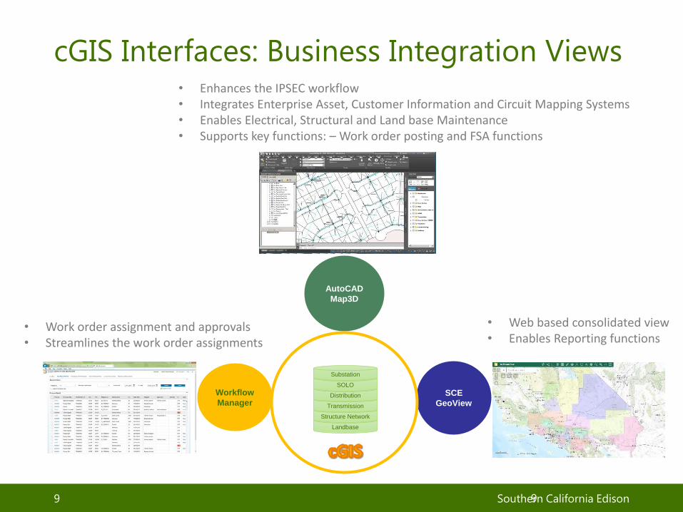
cGIS Interfaces: Business Integration Views
CONFIDENTIAL9 Southern California Edison9
SCE
GeoView
AutoCAD
Map3D
Workflow
Manager
Landbase
Structure Network
Transmission
Distribution
SOLO
Substation
• Enhances the IPSEC workflow• Integrates Enterprise Asset, Customer Information and Circuit Mapping Systems• Enables Electrical, Structural and Land base Maintenance• Supports key functions: – Work order posting and FSA functions
• Web based consolidated view• Enables Reporting functions
• Work order assignment and approvals• Streamlines the work order assignments

SCE GeoView – Key Business Support Tool
CONFIDENTIAL10 Southern California Edison
Visibility to work orders
in progress
FEATURES
All electrical asset data
from Transmission to
Meter – in one place
Multiple tools, reports
and widgets to make
better decisions,
quicker
SCE and MB land base
data for all of our
service territory

cGIS Interfaces: SCE-GeoView – Enabler for Planning
Southern California Edison11
SCE-GeoView
Interface
Review Work
order polygons
11
Import Design
in Map3D
Analyze Work
Area
Define Work order
Polygon
Export and Design
in AUD
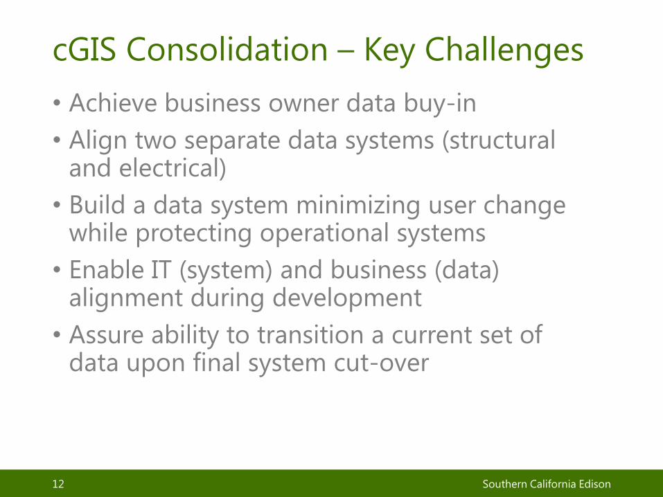
cGIS Consolidation – Key Challenges
• Achieve business owner data buy-in
• Align two separate data systems (structural and electrical)
• Build a data system minimizing user change while protecting operational systems
• Enable IT (system) and business (data) alignment during development
• Assure ability to transition a current set of data upon final system cut-over
CONFIDENTIAL12 Southern California Edison
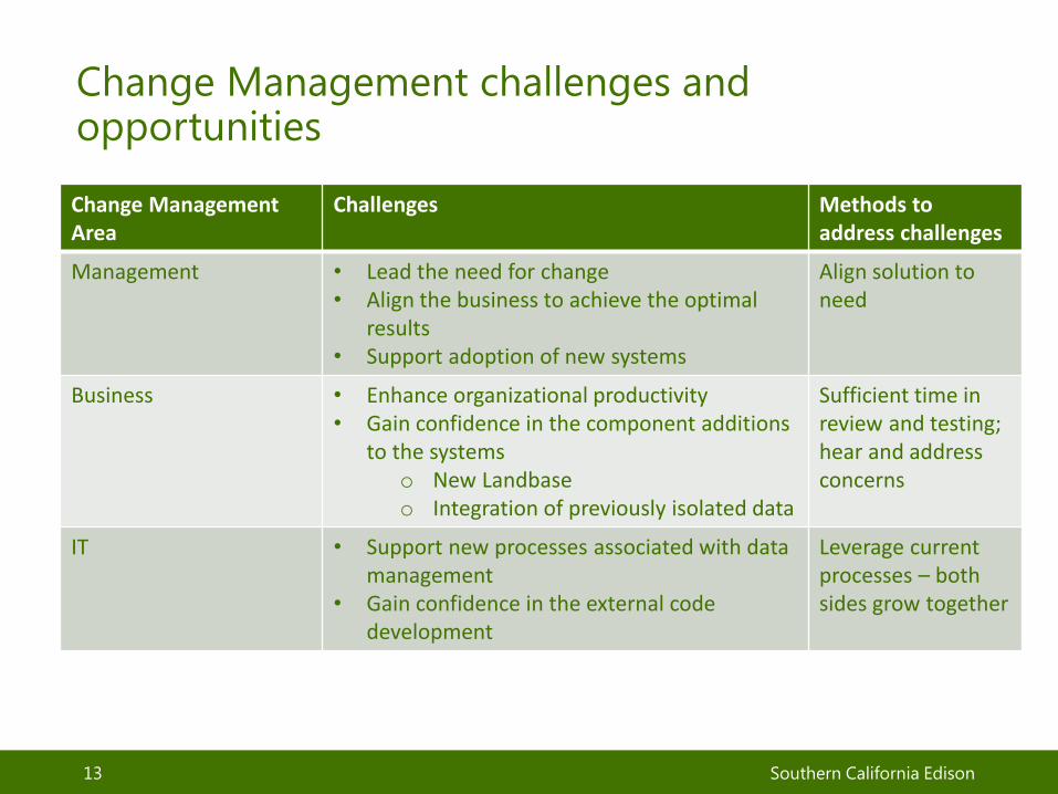
Change Management challenges and opportunities
Southern California Edison13
Change Management Area
Challenges Methods toaddress challenges
Management • Lead the need for change• Align the business to achieve the optimal
results• Support adoption of new systems
Align solution to need
Business • Enhance organizational productivity • Gain confidence in the component additions
to the systems o New Landbase o Integration of previously isolated data
Sufficient time in review and testing; hear and address concerns
IT • Support new processes associated with data management
• Gain confidence in the external code development
Leverage current processes – both sides grow together
SCE cGIS – Enables GRID Modernization Investments
• Enabler for planning, grid operations, metering, distributed generation management, situational awareness, and outage management
• Key to data quality improvements – Transformer-Meter connectivity; Critical-to-Outage management operations
• Establishes the framework for single instance of truth to enabling structural and electric functionality into single applications
• Drive grid modernization technology through new network channels
Southern California Edison14

Thank you
Southern California Edison15