celebrating maps and their stories
TRANSCRIPT

16 January – 19 July 2015National Library Building16 January – 19 July 2015National Library Building
Celebrating maps and their stories
Celebrating maps and their stories

2


4
Singapore’s First Topographical and City Map5Mind the Gap: Mapping the Other6-8Land of Gold and Spices: Early Maps of Southeast Asia and Singapore
9-11Island of Stories: Singapore Maps 12-13
144
Visit the following exhibitions at Geo|Graphic:
Maps are fascinating objects; they not only tell us about the places they depict but also how their makers saw the world around them. For Singapore in particular, maps are a window to our early history – before the arrival of the British in 1819. The National Library is pleased to present Geo|Graphic, an offering of exhibitions and programmes that explore maps and mapping.
SEA STATE 8 SEABOOK
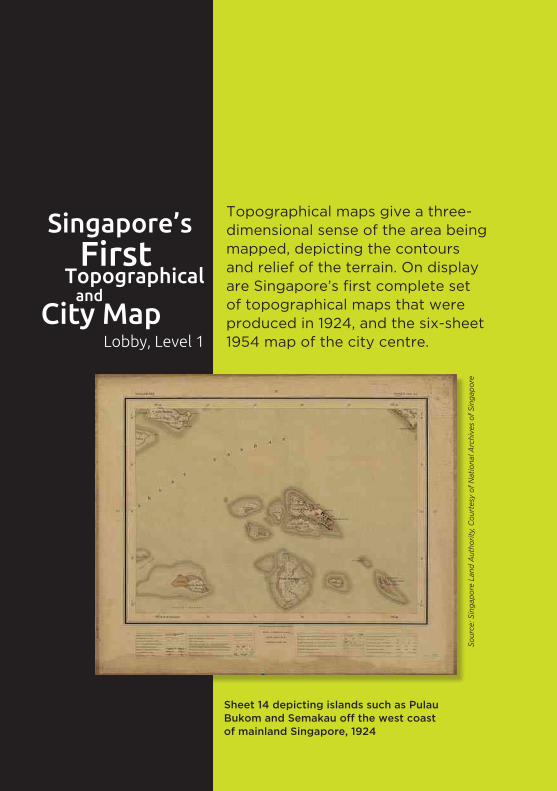
Singapore’sFirst
Topographical
City Mapand
Lobby, Level 1
Topographical maps give a three-dimensional sense of the area being mapped, depicting the contours and relief of the terrain. On display are Singapore’s first complete set of topographical maps that were produced in 1924, and the six-sheet 1954 map of the city centre.
Sheet 14 depicting islands such as Pulau Bukom and Semakau off the west coast of mainland Singapore, 1924
Sour
ce: S
inga
pore
Lan
d A
utho
rity,
Cou
rtes
y of
Nat
iona
l Arc
hive
s of
Sin
gapo
re

6
Mind the Gap presents the works of three Singapore-based contemporary artists who harness the strategies of data collection and mapping to investigate what lies
beneath the surface of contemporary life.
Michael LeeWork in progress for not here, not there (after Russell Lee) from the Bibliotopia series (2015)
Mapping the OtherMind the Gap:
In this work titled Bibliotopia, Michael Lee uses the device of the mind map to uncover the “secret bookscape” of Singapore’s book culture. Focusing on the genres of short fiction, horror and the teen novel through the literary output of Catherine Lim, Russell Lee and Adrian Tan – the artist draws out secrets that are hidden within, or exposed by narratives on identity, adolescence, and the ghostly in Singapore.
Michael Lee is an artist, curator and publisher whose works focus on urban memory and fiction, with an emphasis on their contexts and issues of loss.
Bibliotopiaby Michael Lee | Promenade, Level 7
6

In the installation Outliers by Jeremy Sharma, are four white polystyrene blocks with undulating surfaces that capture the signals of dying stars (pulsars) in material form. Sharma, with the help of a pulsar scientist, has been collecting and categorising the radiographic data of selected pulsars. His work contemplates the profound space-time distance the signals of dying stars travel to communicate their death throes.
Jeremy Sharma instigates investigative processes to inform the formal expressions of his painterly and sculptural practice.
by Jeremy Sharma | Promenade, Level 8
Outliers
Jeremy Sharma Work in progress for Outliers (2014-2015)

88
In this video installation, Sherman Ong uses the documentary/ethnographic film genre to tell stories of migration, trans-border identities, myths, and memories in the islands of Southeast Asia. The histories and contemporary stories of the region are explored through the nine individuals featured in the video vignettes.
Sherman Ong is a filmmaker, photographer and visual artist whose practice centres on the relationship between place and the human condition.
Sherman OngVideo stills from Fables of Nusantara (2015)
Islands In Between
by Sherman Ong | Promenade, Level 9
... The Seas Will Sing And The Wind Will Carry Us… (Fables Of Nusantara)

Asia, particularly Southeast Asia, had a strong hold
over the imaginations of early Europeans as a source
of gold, spices and all things exotic.
Land of Gold and Spices presents a fascinating look
at how Southeast Asia was perceived, conceived of
and mapped by the Europeans from the 15th to the
early 19th centuries.
Gallery, Level 10

10
Some highlights of the exhibition include:
Southeast Asia as plotted by Claudius Ptolemy, a 2nd-century Greek geographer.
A map from Ptolemy’s Geography, printed in 1486
Col
lect
ion
of N
atio
nal L
ibra
ry, S
inga
pore
10
The maps featured in this exhibition are from the
National Library, Singapore’s rare maps collection and
tell stories of the European presence in the region. The
exhibition features printed and hand-drawn maps as
well as sailing instructions that point to Singapore’s
early history before the arrival of the British in 1819.
On special loan from European libraries are rare maps,
such as indigenous Southeast Asian maps, on display
for the very first time in Singapore.

This map that helped to break the Portuguese monopoly in the spice trade.
The island of Singapore is referred to by three different names in this Dutch map – Paulau Panjang (Long Island), Iatana (Ujong Tanah or Land’s End) or Sincapura.
Col
lect
ion
of N
atio
nal L
ibra
ry, S
inga
pore
Leid
en U
nive
rsity
Lib
rary
, 00
6-14
-015
A map of the southern part of the Strait of Melaka
A map from Jan Huygen van Linschoten’s Itinerario published in 1598
12
Some highlights of the exhibition include:
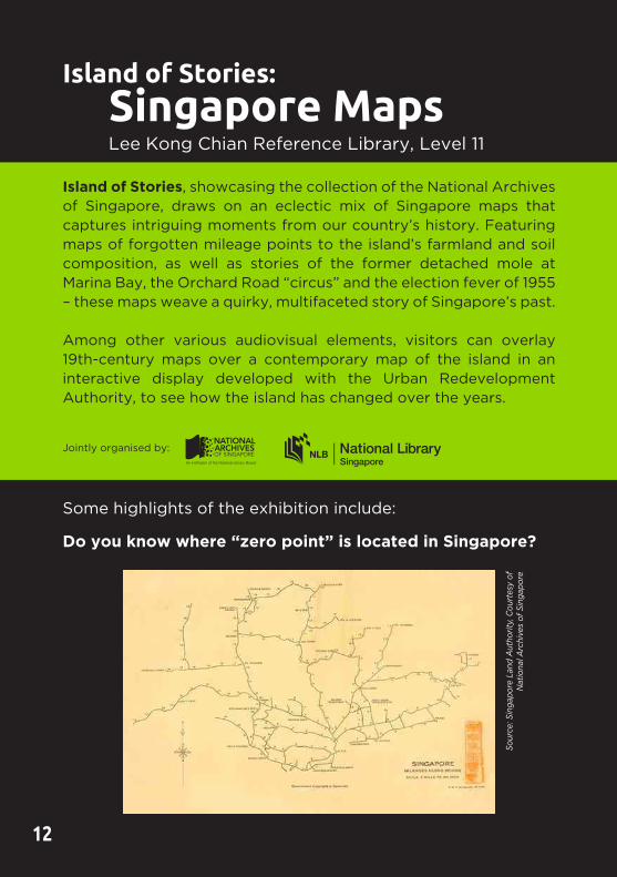
Do you know where “zero point” is located in Singapore?
12
Island of Stories, showcasing the collection of the National Archives of Singapore, draws on an eclectic mix of Singapore maps that captures intriguing moments from our country’s history. Featuring maps of forgotten mileage points to the island’s farmland and soil composition, as well as stories of the former detached mole at Marina Bay, the Orchard Road “circus” and the election fever of 1955 – these maps weave a quirky, multifaceted story of Singapore’s past.
Among other various audiovisual elements, visitors can overlay 19th-century maps over a contemporary map of the island in an interactive display developed with the Urban Redevelopment Authority, to see how the island has changed over the years.
Jointly organised by:
Island of Stories:
Lee Kong Chian Reference Library, Level 11
Singapore Maps
Sour
ce: S
inga
pore
Lan
d A
utho
rity,
Cou
rtes
y of
N
atio
nal A
rchi
ves
of S
inga
pore

Cou
rtes
y of
Nat
iona
l Arc
hive
s of
the
Uni
ted
Kin
gdom
, WO
106-
2529
(12
)
A 1942 British map that was drawn up on the day the Japanese won the battle for Singapore.
An 1846 survey of the Straits of Singapore by John Turnbull Thomson, Singapore’s first government surveyor.
Sour
ce: U
rban
Red
evel
opm
ent A
utho
rity,
Cou
rtes
y of
N
atio
nal A
rchi
ves
of S
inga
pore

14
SEA STATE 8 SEABOOKan Art Project by Charles Lim | Gallery, Level 11
14
Part of the SEA STATE series, SEABOOK follows Charles Lim’s solo-exhibition, “In Search of Raffles’ Light” (2013) held at the NUS Museum. SEABOOK is conceived by the artist, as a site for the accumulation of archival materials, anecdotes and memories that unravels Singapore’s relationship with the sea. Developed with the librarians from the National Library, the project attempts to highlight the range of primary resources available on the sea from the colonial and post-colonial periods. In effect, SEABOOK aspires to be the most extensive cultural study of Singapore’s troubled relationship with the sea.
Charles Lim will represent Singapore in the 2015 Venice Biennale. He has a close relationship with the sea, being a former national sailor and having represented Singapore in the 1996 Olympics.
Jointly organised by:
Charles LimSea Safe (2014)

Conducted in English | *All Saturdays and Sundays, 2pmConducted in Mandarin | *All Saturdays and Sundays, 2.30pm
Meeting point: Outside the Gallery, Level 10
Free weekend guided tours are available from February 2015. Tours are limited to 20 participants per session, on a first-come-first-served basis.
For enquiries, please email [email protected]
* There will be no tours on public holidays.
Schools are able to organise a self-guided tour facilitated by their teachers. A handy educator’s guide/teaching aid for teachers as well as activity sheets for students are available. Interested schools can email [email protected] for more details.
MAPS! At the Public LibrariesCheck out our interactive exhibition MAPS! which explores maps and navigation through history at the following libraries near you!
PUBLIC LIBRARY DATEJurong Regional Library, Level 1 21 Jan 2015 – 26 Feb 2015Bishan Public Library, Level 1, Foyer 28 Feb 2015 – 5 Apr 2015Central Public Library, Basement 1 7 Apr 2015 – 14 Jun 2015Woodlands Regional Library, Level 3 15 Jun 2015 – 29 Jul 2015
Curator’s Tour Part 1 (Land of Gold and Spices)Conducted in English | 26 Feb, 20 Mar, 17 Apr, 15 May, 19 Jun, 10 Jul 2015, 7.30pm
Meeting point: Outside the Gallery, Level 10
Curator’s Tour Part 2 (Island of Stories)Conducted in English | 26 Feb, 20 Mar, 17 Apr, 15 May, 19 Jun, 10 Jul 2015, 9.00pm
Meeting point: Outside the Lee Kong Chian Reference Library, Level 11
Free admission. Tours are limited to 20 participants per session, on a first-come-first-served basis.
For enquiries, please email [email protected]
Weekend Guided Tour
Gallery, Level 10 and 11Self-guided Tour
School

16
Maps that Shaped Singapore 12 Dec 2014 – 28 Feb 2015Lee Kong Chian Reference Library, Level 8
Singapore’s urban landscape has been shaped by its various Concept Plans – the country’s strategic land use and transportation plans. By showcasing these Concept Plans and publications related to land use in Singapore, this book display examines the background and impact of Concept Plans in shaping the country’s urban environment.
16
BO
OK
DIS
PL
AY
The Spice Islands’ Impact on the Mapping of the WorldWednesday, 21 Jan, 7.00pm – 9.00pmThe Pod, Level 16Speaker: Dr David E. Parry
How did the search for a sea route to the “Indies” and “Isles of Spicerie” became the Holy Grail of the great Renaissance explorers, revealing the continents of Africa and North and South America? Discover this and more as renowned soil scientist, Dr Parry shares his experience as an avid map collector and about his book The Cartography of the East Indian Islands.
Cartography at National Geographic: From Crow Quill Pen to ComputerThursday, 5 Mar, 7.00pm – 8.30pmPossibility Room, Level 5Speaker: Mr Juan José Valdés
Technology has modified the way maps have been traditionally researched, designed and edited. This is nowhere more evident than at the National Geographic Society, with its cartographic
PR
OG
RA
MM
ES

tradition spanning over 100 years; their cartographers have now embraced the fast-paced digital world of map-making. Speaking live from Washington DC via web broadcast, Mr Juan José Valdés, official geographer of the National Geographic Society, addresses the society’s significant milestones and their impact on its maps and map products.
Mapping Histories: Cartographic Representation of Singapore and its LimitsSaturday, 21 Mar, 2.00pm – 4.00pmPossibility Room, Level 5Speaker: Dr Imran bin Tajudeen
Maps record both cultural and natural physical data to varying degrees and a comparative perspective across time can reveal useful information about changes to multiple aspects of the landscape. In this session, Dr Imran, an assistant professor at the National University of Singapore’s Department of Architecture, will discuss the use of old maps to uncover the lesser-known aspects of place histories in Singapore.
Mapping Singapore in World War II: A Global PerspectiveSaturday, 11 Apr, 2.00pm – 4.00pmPossibility Room, Level 5Speaker: Mr Mok Ly Yng
This presentation reviews the organisation of worldwide mapping efforts by the British and American mapping agencies during World War II as well as Singapore’s military mapping from a global perspective. Selected military maps of Singapore that were in use or produced during World War II with significant points of interest reflected will be highlighted during this session by mapping consultant, Mr Mok Ly Yng.
PR
OG
RA
MM
ES

18
Changing Landscapes of SingaporeSaturday, 25 Apr, 2.00pm – 4.00pmPossibility Room, Level 5Speaker: Associate Professor Victor R Savage
Over the last 190 years of Singapore’s history, the city-state landscapes have undergone tremendous changes and transformations. This talk by Associate Professor Victor R. Savage from the National University of Singapore’s Department of Geography, provides a glimpse into Singapore’s past and current landscapes and their implications in the imageability and legibility of Singapore to residents and tourists alike.
Planning for Singapore: How Do We Do It? Saturday, 16 May, 2.00pm – 4.00pmPossibility Room, Level 5Speaker: Mr Daniel Leong
Given Singapore’s limited space and multiple land uses, the nation’s planners use a comprehensive framework that provides an integrated approach to sustainable development. Tools developed based on Geographic Information Systems (GIS) help to enhance and plan for the needs of the current and future generations of Singaporeans. Mr Daniel Leong, a planner with the Urban Redevelopment Authority, shares how these GIS tools can help to create a vibrant and sustainable city of distinction.
PR
OG
RA
MM
ES
The programmes are limited to 120 participants per session, on a first-come-first-served basis. Admission is free. Please visit www.nlb.gov.sg/golibrary or scan the QR code to register.
18

Supported by:
The Past is A Foreign Country is a selection of projects funded by the irememberSG fund that explore issues of territoriality, space and environment through the trope of memory in Singapore. For more information of the specific exhibitions and programmes, please visit iremember.sg.
A special presentation
April to August 2015 I Promenade, Level 10, National Library Building
The Past is A Foreign Country:
by the Singapore Memory Project
• PointsofDeparturebyJuriaToramae&JeromeLim
• IslandNationbyCaptured(EdwinKoo,ZakariaZainal&JulianaTan)
•MemoriesofPulauBranibyMuhammadNadjadAbdulRahim
• TheMemoriesofTreesbyRobertZhaoRenhui
• Singapore’sOrchidHistorybyHedrickKwan
• BuiltInSGbyMekaStudios
• Architecture&ArchitectsbyDONOTDESIGN
• irememberParksbySingaporeFurnitureIndustriesCouncil
• BuildingMemoriesbyAchates360&KohHongTeng
Projects showcase include:
Photo of Pulau Jong from Points of Departure Photo credit: Marcus Ng

20
GENERAL INFORMATION GUIDE
ADDRESSNational Library Building100 Victoria Street, Singapore 188064
OPERATING HOURSMonday to Sunday,10am – 9pm (except Public Holidays)
GETTING TO THE LIBRARY
BY TRAIN 10-minute walk from:Bugis MRT StationBras Basah MRT StationCity Hall MRT Station
BY BUSCosmic Insurance BuildingBus-stop (01029)7, 32, 51, 61, 63, 80, 145, 175, 197, 851
Bras Basah ComplexBus-stop (01019)2, 12, 33, 130, 133, 960, NR7
St. Joseph’s Church Bus-stop (01013)130, 133, 145, 197, 851, 960, NR7
Hotel Grand Pacific Bus-stop (01012)2, 7, 12, 32, 33, 51, 61, 63, 80, 175, NR7
BY TAXIPick-up and drop-off points along Middle Road and Victoria Street.
BY CARParking is available at the National Library Building.
Operating hours: Monday to Sunday, 7am to 11.30pm
Information is correct at time of print. The National Library, Singapore reserves the right to make changes to the programmes without prior notice.