california high-speed train project eir/eis
TRANSCRIPT
Page 1-i
ne

California High-Speed Train Project EIR/EIS
Staff Recommendations: Preferred Alternative
Prepared by:
URS/HMM/Arup Joint Venture
November 2013

CALIFORNIA HIGH-SPEED TRAIN PROJECT EIR/EIS STAFF RECOMEMENDATIONS
FRESNO TO BAKERSFIELD SECTION PREFERRED ALTERNATIVE
Page i
Table of Contents
Page
Summary ..................................................................................................................... S-1 1.0 Introduction .................................................................................................... 1-1 2.0 Summary of Comments ................................................................................... 2-1
2.1 California Legislators ......................................................................................... 2-1 2.2 Project Area Local Governments ........................................................................ 2-2 2.3 Federal Agencies and Tribes .............................................................................. 2-2 2.4 State Agencies ................................................................................................. 2-2 2.5 Regional and Other Public Agencies ................................................................... 2-2 2.6 Businesses ....................................................................................................... 2-2 2.7 Organizations ................................................................................................... 2-3 2.8 Individuals ....................................................................................................... 2-3
3.0 Alternatives Considered .................................................................................. 3-1 3.1 Preliminary Alternatives Analysis – June 2010 .................................................... 3-1 3.2 Supplemental Alternatives Analysis – September 2010 ........................................ 3-2 3.3 Supplemental Alternatives Analysis – May 2011 .................................................. 3-4
3.3.1 Fresno Subsection: .................................................................................... 3-4 3.3.2 Hanford/Kings County Subsection: ............................................................. 3-4 3.3.3 Corcoran Subsection: ................................................................................ 3-5 3.3.4 Allensworth Subsection: ............................................................................ 3-5 3.3.5 Wasco-Shafter Subsection: ........................................................................ 3-5 3.3.6 Bakersfield Subsection: ............................................................................. 3-5 3.3.7 Use of BNSF Right-of-Way: ........................................................................ 3-5
3.4 Supplemental Alternatives Analysis (December 2011) ......................................... 3-5 3.4.1 Refinements of Alternatives ....................................................................... 3-6
3.5 Alternatives Evaluation ...................................................................................... 3-8 3.5.1 Environmental Impacts .............................................................................. 3-8
3.5.1.1 Natural Resources ............................................................................ 3-8 3.5.2 Section 4(f) Uses .................................................................................... 3-12 3.5.3 Community Resources and Land Use ........................................................ 3-12
3.5.3.1 Community Impacts by Individual Geographic Alternative ................. 3-18 3.5.4 Capital Costs ........................................................................................... 3-19 3.5.5 Constructability Issues............................................................................. 3-19 3.5.6 Ridership and Revenue/Travel Times/Travel Conditions ............................. 3-20
3.6 Station Locations ............................................................................................ 3-20 3.6.1 Fresno Station – Preferred Alternative ...................................................... 3-20 3.6.2 Kings/Tulare Regional Station–East Alternative ......................................... 3-21 3.6.3 Kings/Tulare Regional Station–West Alternative ........................................ 3-22 3.6.4 Bakersfield Station–North Alternative ....................................................... 3-24 3.6.5 Bakersfield Station–South Alternative ....................................................... 3-25 3.6.6 Bakersfield Station–Hybrid Alternative ...................................................... 3-26
3.7 Regulatory Considerations ............................................................................... 3-28 3.8 Agency Consultations ...................................................................................... 3-28
4.0 Preferred Alternative ...................................................................................... 4-1 4.1 Preferred Alignment .......................................................................................... 4-1 4.2 Stations ........................................................................................................... 4-2 4.3 Heavy Maintenance Facility ............................................................................... 4-2
CALIFORNIA HIGH-SPEED TRAIN PROJECT EIR/EIS STAFF RECOMEMENDATIONS
FRESNO TO BAKERSFIELD SECTION PREFERRED ALTERNATIVE
Page ii
Tables
Table 1 Natural Resources Impacts in the Fresno to Bakersfield Section ................................. 3-9
Table 2 Community Resource Impacts in the Fresno to Bakersfield Section .......................... 3-15
Figures
Figure S-1 Fresno to Bakersfield Section Preferred Alternative ................................................... 2 Figure 1 Alternatives Carried Forward and Heavy Maintenance Facility Sites ............................ 3-3 Figure 2 Fresno to Bakersfield Section Project Alternatives ..................................................... 3-7 Figure 3 Downtown Fresno Station – Preferred Mariposa Street Alternative .......................... 3-21 Figure 4 Kings/Tulare Regional Station–East Alternative ....................................................... 3-22 Figure 5 Kings/Tulare Regional Station–West Alternative (at-grade option) ............................ 3-23 Figure 6 Preferred Station Alternative Kings/Tulare Regional Station–West Alternative (below-
grade option) ...................................................................................................... 3-24 Figure 7 Bakersfield Station–North Alternative ..................................................................... 3-25 Figure 8 Bakersfield Station–South Alternative ..................................................................... 3-26 Figure 9 Preferred Station Alternative Bakersfield Station–Hybrid Alternative ......................... 3-27 Figure 10 Fresno to Bakersfield Preferred Alternative ............................................................. 4-3
ATTACHMENT
Development of Alternatives 1.0 HST Project-Level Alternatives Development Process: How the Initial Range of
Alternatives Was Developed 2.0 Development Process for Project-Level Alternatives
2.1 Methodology of the Alternatives Analysis 2.2 Preliminary and Supplemental Alternatives Analyses 2.3 Refinements of Alternatives
Tables
Table 1 Alternatives Analysis Reports for the Fresno to Bakersfield Section
Figures
Figure 1 Alignment options identified for Fresno to Bakersfield in the 2005 Statewide Program EIR/EIS
Figure 2 Alternatives carried forward and heavy maintenance facility sites Figure 3 Fresno to Bakersfield Section project alternatives from Revised
DEIR / Supplemental DEIS (Authority and FRA 2012f)
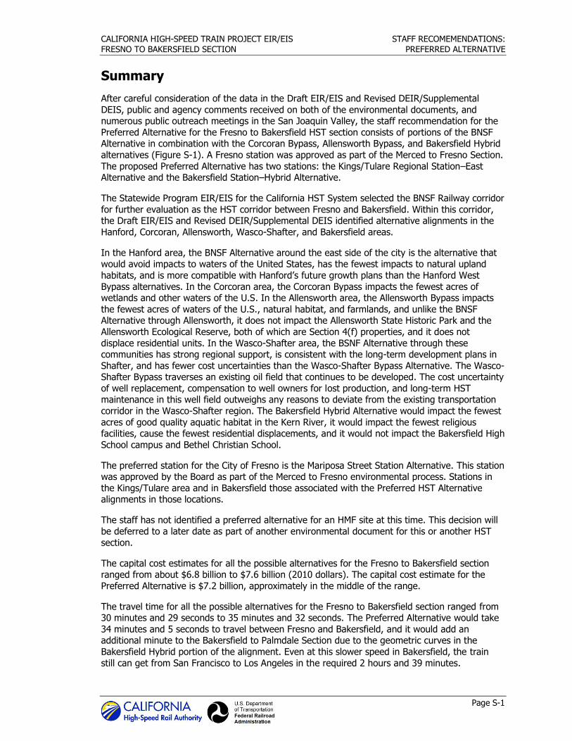
Summary

CALIFORNIA HIGH-SPEED TRAIN PROJECT EIR/EIS STAFF RECOMEMENDATIONS:
FRESNO TO BAKERSFIELD SECTION PREFERRED ALTERNATIVE
Page S-1
Summary
After careful consideration of the data in the Draft EIR/EIS and Revised DEIR/Supplemental
DEIS, public and agency comments received on both of the environmental documents, and numerous public outreach meetings in the San Joaquin Valley, the staff recommendation for the
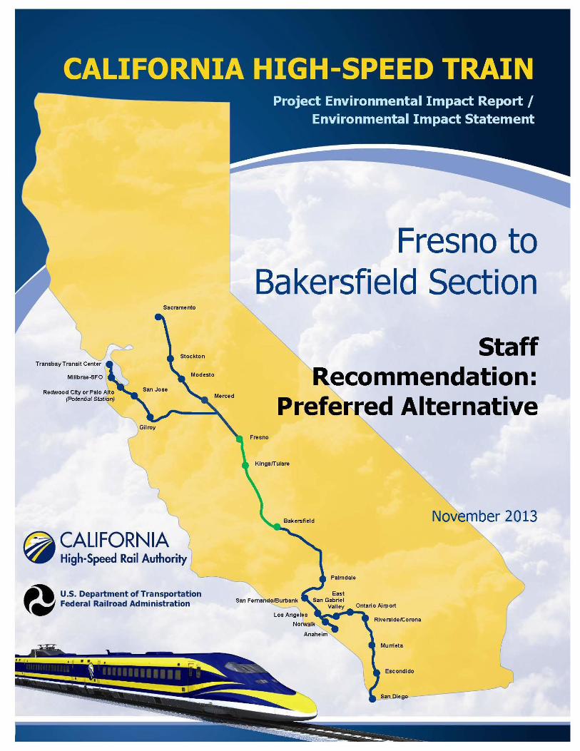
Preferred Alternative for the Fresno to Bakersfield HST section consists of portions of the BNSF Alternative in combination with the Corcoran Bypass, Allensworth Bypass, and Bakersfield Hybrid
alternatives (Figure S-1). A Fresno station was approved as part of the Merced to Fresno Section.
The proposed Preferred Alternative has two stations: the Kings/Tulare Regional Station–East Alternative and the Bakersfield Station–Hybrid Alternative.
The Statewide Program EIR/EIS for the California HST System selected the BNSF Railway corridor
for further evaluation as the HST corridor between Fresno and Bakersfield. Within this corridor, the Draft EIR/EIS and Revised DEIR/Supplemental DEIS identified alternative alignments in the
Hanford, Corcoran, Allensworth, Wasco-Shafter, and Bakersfield areas.
In the Hanford area, the BNSF Alternative around the east side of the city is the alternative that would avoid impacts to waters of the United States, has the fewest impacts to natural upland
habitats, and is more compatible with Hanford’s future growth plans than the Hanford West
Bypass alternatives. In the Corcoran area, the Corcoran Bypass impacts the fewest acres of wetlands and other waters of the U.S. In the Allensworth area, the Allensworth Bypass impacts
the fewest acres of waters of the U.S., natural habitat, and farmlands, and unlike the BNSF Alternative through Allensworth, it does not impact the Allensworth State Historic Park and the
Allensworth Ecological Reserve, both of which are Section 4(f) properties, and it does not
displace residential units. In the Wasco-Shafter area, the BSNF Alternative through these communities has strong regional support, is consistent with the long-term development plans in
Shafter, and has fewer cost uncertainties than the Wasco-Shafter Bypass Alternative. The Wasco-Shafter Bypass traverses an existing oil field that continues to be developed. The cost uncertainty
of well replacement, compensation to well owners for lost production, and long-term HST maintenance in this well field outweighs any reasons to deviate from the existing transportation
corridor in the Wasco-Shafter region. The Bakersfield Hybrid Alternative would impact the fewest
acres of good quality aquatic habitat in the Kern River, it would impact the fewest religious facilities, cause the fewest residential displacements, and it would not impact the Bakersfield High
School campus and Bethel Christian School.
The preferred station for the City of Fresno is the Mariposa Street Station Alternative. This station was approved by the Board as part of the Merced to Fresno environmental process. Stations in
the Kings/Tulare area and in Bakersfield those associated with the Preferred HST Alternative alignments in those locations.
The staff has not identified a preferred alternative for an HMF site at this time. This decision will
be deferred to a later date as part of another environmental document for this or another HST
section.
The capital cost estimates for all the possible alternatives for the Fresno to Bakersfield section ranged from about $6.8 billion to $7.6 billion (2010 dollars). The capital cost estimate for the
Preferred Alternative is $7.2 billion, approximately in the middle of the range.
The travel time for all the possible alternatives for the Fresno to Bakersfield section ranged from 30 minutes and 29 seconds to 35 minutes and 32 seconds. The Preferred Alternative would take
34 minutes and 5 seconds to travel between Fresno and Bakersfield, and it would add an additional minute to the Bakersfield to Palmdale Section due to the geometric curves in the
Bakersfield Hybrid portion of the alignment. Even at this slower speed in Bakersfield, the train
still can get from San Francisco to Los Angeles in the required 2 hours and 39 minutes.
CALIFORNIA HIGH-SPEED TRAIN PROJECT EIR/EIS STAFF RECOMEMENDATIONS:
FRESNO TO BAKERSFIELD SECTION PREFERRED ALTERNATIVE
Page S-2
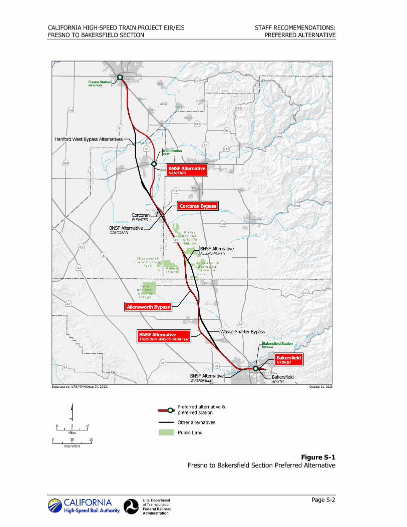
Figure S-1 Fresno to Bakersfield Section Preferred Alternative
Section 1 Introduction


CALIFORNIA HIGH-SPEED TRAIN PROJECT EIR/EIS STAFF RECOMEMENDATIONS:
FRESNO TO BAKERSFIELD SECTION PREFERRED ALTERNATIVE
Page 1-1
1.0 Introduction
This document presents the Authority staff’s recommendation for the Preferred Alternative for the
Fresno to Bakersfield Section and provides explanation of why it was identified. Neither the Draft EIR/EIS nor the Revised DEIR/Supplemental DEIS identified a preference among the alternatives
presented.
The recommended Preferred Alternative extends from Fresno to Bakersfield and includes portions of the BNSF Alternative in combination with the Corcoran Bypass, Allensworth Bypass, and
Bakersfield Hybrid alternatives. A Fresno station was selected as part of the Merced to Fresno
Section. The potential Preferred Alternative has two stations: the Kings/Tulare Regional Station–East Alternative and the Bakersfield Station–Hybrid Alternative. The Authority staff does not
recommend making a selection of an HMF site at this time.
To facilitate the identification of a preferred HST alternative and station locations in the Final EIR/EIS, the Authority staff will present their recommendation as an action item to the Authority
at the November 7, 2013, Board meeting and provide an opportunity for the Board to offer input and direction to staff. Following the Board meeting, staff will complete the National
Environmental Policy Act (NEPA)/Section 404/408 Clean Water Act (CWA) integration process
with the U.S. Army Corps of Engineers (USACE) and the U.S. Environmental Protection Agency (EPA). With concurrence from these agencies that the Preferred Alternative is the Least
Environmentally Damaging Practicable Alternative (LEDPA), staff will complete the Final EIR/EIS. At the conclusion of this environmental review process, the Authority Board will consider whether
to certify the Final EIR/EIS and adopt necessary findings,1 and take action to approve the
preferred north-south alignment alternative and station locations for this portion of the HST System; and it is further anticipated that the Federal Railroad Administration (FRA) will issue a
Record of Decision (ROD) on the Final EIR/EIS, followed by a decision by the Surface Transportation Board (STB).
The identification of the Preferred Alternative is based upon the data presented in the Fresno to
Bakersfield Section Draft EIR/EIS and the Revised DEIR/Supplemental DEIS, including the
supporting technical reports, comments received on the Fresno to Bakersfield Section Draft EIR/EIS (the 60-day comment period concluded on October 13, 2011), the Fresno to Bakersfield
Section Revised DEIR/Supplemental DEIS (the 90-day comment period ended on October 19, 2012), and comments provided by local communities and stakeholders in meetings following the
close of the public comment period on the Revised DEIR/Supplemental DEIS.
The Draft EIR/EIS and the Revised DEIR/Supplemental DEIS provided an overview of the relative differences among physical and operational characteristics and potential environmental
consequences associated with the HST alternatives and station location options, including the
following:
Physical/operational characteristics:
Alignment
Length
Capital cost
Travel time
Ridership
1 The Authority believes that certification and findings adoption are not required because Surface Transportation Board (STB) jurisdiction (formalized earlier this year) preempts CEQA, but intends to complete the CEQA process anyway because it would be confusing to the public to remove the CEQA portions from the EIR/EIS document. By doing so, the Authority does not waive the effects of STB’s jurisdiction.
CALIFORNIA HIGH-SPEED TRAIN PROJECT EIR/EIS STAFF RECOMEMENDATIONS:
FRESNO TO BAKERSFIELD SECTION PREFERRED ALTERNATIVE
Page 1-2
Constructability
Operational issues
Environmental impacts:
Transportation-related topics (air quality, noise and vibration, and energy)
Human environment (land use and community impacts, farmlands and agriculture,
aesthetics and visual resources, socioeconomics, utilities and public services, hazardous materials and wastes)
Cultural resources (archaeological resources, historical properties)
Natural environment (geology and seismic hazards, hydrology and water resources, and
biological resources and wetlands) Section 4(f)/6(f) resources (certain types of publicly owned parklands, recreation areas,
wildlife/waterfowl refuges, and historical sites).
In identifying a Preferred Alternative, the Authority staff was guided by the project purpose and
need and project objectives found in Chapter 1, Project Purpose, Need, and Objectives of the Revised DEIR/Supplemental DEIS as well as the objectives and criteria as developed for and
recorded in the Visalia-Tulare-Hanford Station Feasibility Study (VTH Study) (Authority 2007), Fresno to Bakersfield Preliminary Alternatives Analysis Report (AA), California High-Speed Rail Authority, Board Briefing (Preliminary AA Report) (Authority and FRA 2010a), the Supplemental Alternatives Analysis (Authority and FRA 2010b), a second Supplemental Alternatives Analysis (Authority and FRA 2011b), and a third Supplemental Alternatives Analysis (Authority and FRA
2011c), as well as a hybrid alternative alignment developed for the Bakersfield subsection to
address substantive comments received during public and agency review of the Draft EIR/EIS. These documents can found at http://www.hsr.ca.gov/. Additionally, these criteria are consistent
with Section 404(b)(1), Guidelines of the Clean Water Act (40 CFR 230–233), including minimizing impacts on Waters of the U.S. and other sensitive environmental resources.
As a result of the analyses incorporated in the Draft EIR/EIS, the Revised DEIR/Supplemental
DEIS, and the subsequent Final EIR/EIS as well as the biological assessment of ecosystems impacts and cultural, and community impacts, the Authority and FRA anticipate that the EPA and
USACE will conclude that the Preferred Alternative is the LEDPA, consistent with USACE’s permit
program (33 CFR Part 320–331) and EPA’s Section 404(b)(1) Guidelines (40 CFR 230–233). The LEDPA determination is within the jurisdiction of USACE and EPA; the Authority may only
recommend a LEDPA and provide analysis in support of USACE and EPA finding.

Section 2 Summary of Comments

CALIFORNIA HIGH-SPEED TRAIN PROJECT EIR/EIS STAFF RECOMEMENDATIONS:
FRESNO TO BAKERSFIELD SECTION PREFERRED ALTERNATIVE
Page 2-1
2.0 Summary of Comments
During the comment period, there were 1,479 submissions and 3,174 comments on the Fresno to
Bakersfield Section Draft EIR/EIS, and 683 submissions and 4,642 comments on the Revised DEIR/Supplemental DEIS. The comments covered a wide range of issues and represented
viewpoints from government agencies, organizations, business groups, businesses, residents, and property owners.
Most comments came from individuals in the general public living, working, or with property
interests in the project study area, and local government jurisdictions in Kings and Kern counties.
Of the 2,162 submissions, approximately 124 generally supported and 630 were generally opposed to the project. Comments received from the general public and local officials in Kings
County strongly opposed any alternative through Kings County. Comments from farmers in the Wasco-Shafter area preferred the BNSF Alternative through Wasco and Shafter to the Wasco-
Shafter Bypass even though they owned property along both alignments. This is because the
boundary to their fields and orchards had already been established by the BNSF Railway in the case of the BNSF Alternative while the Wasco-Shafter Bypass cuts across many fields and
orchards and is perceived to interfere with existing agricultural operations. The city of Wasco does not support the BNSF Alternative because it would have a substantial impact on the
commercial and industrial enterprises of the city. The city of Shafter supports the BNSF Alternative because it more closely fits with their long-term planning vision for the city.
Comments received from the general public and local officials in Kern County rejected all
alternatives with a station in Downtown Bakersfield, which is opposite of the preference for a downtown station near the existing Amtrak station voiced by the city of Bakersfield, Kern County,
and Kern Council of Governments in 2003. The majority of individual and government official comments preferred an alternative that would bypass Bakersfield and locate a station on the
outskirts of the city. There was not a clear majority opinion for one alternative over another in
the Corcoran and Allensworth areas. Commenters provided pros and cons for each alternative in these two areas of the project.
Among comments received from the general public, effects on agricultural and private property
were the top concerns about the project. Also, comments expressed concern over funding availability (including whether any money should be spent on this type of project in light of state
and federal budget deficits) and the accuracy of the ridership projections. Other common environmental concerns included noise and vibration, ecosystem effects, neighborhood impacts,
and safety.
Many submissions suggested changing the Fresno to Bakersfield Section HST alternatives. Most common among these comments was to re-consider an alignment adjacent to I-5 that would
bypass the Fresno to Bakersfield Section corridor altogether or to locate the alignment along SR
99. In addition, other comments suggested a preference for the State of California to use HST funding for other infrastructure improvements. Many of these comments contended that
residents of the San Joaquin Valley did not need and would not use an HST System for travel.
2.1 California Legislators
Congressman Jim Costa, Devin Nunes, Jeff Denham, and Kevin McCarthy, State Senator Michael Rubio, and State Assembly member David Valadao requested a time extension on the public
review period for the Draft EIR/EIS. State Assembly member David Valadao also requested a
time extension on the public review period for the Revised DEIR/Supplemental DEIS. State Senator Michael Rubio expressed support for the HST in the Central Valley; however, he
requested that a decision on an alignment through Downtown Bakersfield be postponed and an alternative alignment south of Bakersfield be considered.
CALIFORNIA HIGH-SPEED TRAIN PROJECT EIR/EIS STAFF RECOMEMENDATIONS:
FRESNO TO BAKERSFIELD SECTION PREFERRED ALTERNATIVE
Page 2-2
2.2 Project Area Local Governments
The City of Fresno supports the alignment through Fresno with a Mariposa Street Station. Kings
County and the City of Hanford do not support an HST alignment in Kings County and would prefer the HST to follow SR 99 or I-5. At a Hanford City Council meeting on October 12, 2012,
the City Council decided not to express a preference for any of the alternatives through Hanford. The City of Corcoran does not agree with any of the three alternatives in or around that city, but
believes that the alternatives that cross through town would have greater impacts than the
Corcoran Bypass Alternative. The City of Visalia supports the BNSF Alternative east of Hanford and its corresponding HST station. The City of Shafter supports the BNSF Alternative and
indicated a preference for below-grade crossings for freight at three roads. The City of Shafter also indicates that the Wasco-Shafter Bypass would result in substantial impacts to agricultural
operations important to the Shafter’s economy. The City of Wasco has stated that an alternative
through the city must be located on the east side of the BNSF Railway to avoid major impacts to Wasco’s economy. The City of Bakersfield, Kern County, and the Kern Council of Governments do
not support an HST alignment through Downtown Bakersfield with a downtown station. They wish to see an alignment that bypasses Downtown Bakersfield with a station on the outskirts of
the city.
2.3 Federal Agencies and Tribes
EPA did not express support for a particular alternative, but was concerned with minimizing
impacts on wetlands, aquatic resources, air quality, and induced growth. USACE did not support a particular alternative. Amtrak provided detailed comments related to different alternatives and
project description information, but did not express support for a specific alternative. The U.S. Department of Interior, Office of Environmental Policy and Compliance sent letters stating they
did not have any comments on the EIR/EIS. The Federal Highway Administrative provided
comments concerning the interface between the HST and federal highways. The USFWS did not submit a comment letter on the Draft EIR/EIS or the Revised DEIR/Supplemental DEIS.
2.4 State Agencies
State agencies that commented on the Draft EIR/EIS and/or the Revised DEIR/Supplemental
DEIS were the Department of Conservation, Department of Fish and Wildlife, Department of Toxic Substances Control, Division of Oil, Gas, and Geothermal Resources, State Lands
Commission, Department of Resources Recycling and Recovery, Department of Transportation,
Public Utilities Commission, Department of Housing and Development, State Water Resources Control Board, Department of Resources Recycling and Recovery, California State University,
Bakersfield, and California State University, Fresno. None of the agencies indicated a preference for any alternative. Comments from state agencies primarily provided additional baseline
information in their areas of expertise, questions regarding environmental impacts, and clarification of the agencies regulatory responsibilities relative to the HST project.
2.5 Regional and Other Public Agencies
The 40 regional and public agencies submitting comments, most of which were water districts, school districts, and irrigation districts, did not state a preference for a specific alternative.
2.6 Businesses
Comments were received from 132 different businesses, and most comments focused on impacts
on their property and/or their business. Businesses whose property would be affected by the project typically stated preference for the alternative that would avoid their property.
CALIFORNIA HIGH-SPEED TRAIN PROJECT EIR/EIS STAFF RECOMEMENDATIONS:
FRESNO TO BAKERSFIELD SECTION PREFERRED ALTERNATIVE
Page 2-3
Several businesses were concerned about the loss of jobs if they were acquired and could not be
relocated, and about impacts on the economy due to the loss of jobs, businesses, and tax revenue for the local jurisdictions. Some businesses were concerned about impacts during
operation and construction, such as loss of access, noise, dust, and visual changes, affecting them.
Forty-four farms or ranches expressed concern about impacts on agriculture and farmlands, such
as their ability to comply with Water Quality Control Board regulations and state pesticide and drift regulations with the project, the cost of changes to agricultural infrastructure including
irrigation systems and waste disposal systems, increased cost of accessing property split by the
HST alignment, the cost of relocating livestock, and the impacts of noise, vibration, dust, and stray voltage on livestock.
Unique businesses in the Fresno to Bakersfield Section are the BNSF Railway and the UPRR,
because all alternatives would have some adjacency with these railroad corridors. The BNSF Railway did not comment on the Draft EIR/EIS or the Revised DEIR/Supplemental DEIS. The
UPRR provided comments primarily related to their right-of-way and uses proposed in and adjacent to it. They state that their entire right-of-way must be preserved, and the project should
not be located within that right-of-way.
2.7 Organizations
Comments were received from 50 special interest or community organizations, including groups
representing environmental interests or farming interests, groups organized in response to this project, and groups representing other organized stakeholder groups. Organizations supporting
farming interests included the California Farm Bureau Federation; the Farm Bureaus for Fresno and Kings counties; associations for growers and producers; and farmland trusts, and generally
felt the analysis of impacts on farmland was inadequate and suggested an alternative that
followed I-5 or SR 99 in order to minimize impacts on farmland. Organizations formed in response to the HST Project generally opposed the project and either did not express an
alternative preference or requested that the HST follow I-5 or SR 99 or an alignment that bypassed Bakersfield.
2.8 Individuals
The majority of comments from individuals came from residents of Kings and Kern counties
which voiced many of the same concerns as the local governments of these counties. Most of the
comments provided by individuals of Kings County did not want the HST to cross their county, preferring an alternative on either I-5 or SR 99. Most comments from individuals in Kern County
were from residents of metropolitan Bakersfield preferring an alternative that bypasses Downtown Bakersfield with a station on the outskirts of the city.
CALIFORNIA HIGH-SPEED TRAIN PROJECT EIR/EIS STAFF RECOMEMENDATIONS:
FRESNO TO BAKERSFIELD SECTION PREFERRED ALTERNATIVE
Page 2-4
This page intentionally left blank

Section 3 Alternatives Considered

CALIFORNIA HIGH-SPEED TRAIN PROJECT EIR/EIS STAFF RECOMEMENDATION:
FRESNO TO BAKERSFIELD SECTION PREFERRED ALTERNATIVE
Page 3-1
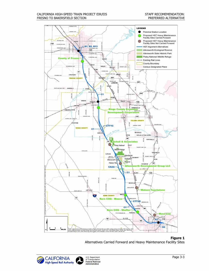
3.0 Alternatives Considered
Following the 2005 Statewide Final Program EIR/EIS, the Authority and FRA selected the BNSF
Railway route for further study between Fresno and Bakersfield in a second-tier, project-level EIR/EIS. The Project EIR/EIS for the Fresno to Bakersfield Section focuses on alternative
alignments along the general BNSF Railway corridor.
In addition to the first-tier decision to advance the BNSF corridor, the Authority conducted a planning study for the potential location of an HST station in the Visalia/Tulare/Hanford area prior
to initiating project-level planning studies for the Fresno to Bakersfield Section. This study, the
Visalia-Tulare-Hanford Station Feasibility Study, was initiated in 2005 and completed in 2007. In addition to the evaluation of potential station locations in the vicinity of Visalia, along the BNSF
and UPRR corridors, the study covered a much larger scope of analysis considering potential HST alignments between Fresno and Bakersfield, including alignments along segments of the UPRR.
The study described associated potential environmental impacts, including impacts on sensitive
land uses, farmland, cultural resources, communities, water resources, floodplains, wetlands, sensitive species, and 4(f) resources. The conclusion provided that a station east of Hanford, on
the BNSF Alignment, would be capable of serving the Visalia-Tulare-Hanford area. The study also concluded that a UPRR alternative would have greater constructability issues and greater
potential noise, cultural, community, and property impacts.
The Authority, in cooperation with FRA, began the environmental review process for the Fresno to Bakersfield Section of the California HST Project, which included a Notice of Intent and Notice
of Preparation (published in 2009) and public scoping process in early 2009. As described in
Chapter 2.0 of the Revised DEIR/Supplemental DEIS, the Fresno to Bakersfield Section includes nine project alternatives: the BNSF Alternative (a single continuous alignment that extends from
Fresno to Bakersfield) and eight additional alignment alternatives (Hanford West Bypass 1, Hanford West Bypass 2, Corcoran Elevated, Corcoran Bypass, Allensworth Bypass, Wasco-Shafter
Bypass, Bakersfield South, and Bakersfield Hybrid), which deviate from the BNSF Alternative for portions of the route to avoid environmental, land use, or community impacts (Figure S-1).
These alternatives were developed using HST system performance criteria and considered
potential effects of the proposed alternatives on the natural and human environment. To define
the project-level alternatives to be evaluated in the Project EIR/EIS , the Authority and FRA prepared the four alternatives analyses (one preliminary report and three supplemental reports)
identified above.
3.1 Preliminary Alternatives Analysis – June 2010
Once components were screened to lowest effects and highest HST performance, a Preliminary Alternatives Analysis compared the alternatives against each other and documented the results.
While the Preliminary Alternatives Analysis process considered multiple criteria, the screening
emphasized the project objective to maximize the use of existing transportation corridors and available rights-of-way, to the extent feasible. The alternatives included in the Preliminary AA
Report followed the existing freight corridors of the BNSF Railway and the UPRR, the SR 43 corridor, and an electrical transmission corridor east of Hanford. It divided the corridor into three
subsections: Fresno, Rural, and Bakersfield. Linking alternatives from each subsection together formed the complete, end-to-end alternatives for the Fresno to Bakersfield Section.
CALIFORNIA HIGH-SPEED TRAIN PROJECT EIR/EIS STAFF RECOMEMENDATIONS:
FRESNO TO BAKERSFIELD SECTION PREFERRED ALTERNATIVE
Page 3-2
Fresno Section: The Preliminary AA Report recommended that three alternatives be carried
forward for consideration in the EIR/EIS:
UPRR East UPRR West
UPRR West/East Crossover
All three of these alternatives were assumed to be elevated through Fresno, to be adjacent to the UPRR right-of-way in Fresno, to leave Fresno to the south, generally along the BNSF corridor,
and to provide a Downtown Fresno Station near Mariposa Street (Figure 1).
Rural Subsection: The Preliminary AA Report recommended that the BNSF–Hanford East Bypass be carried forward for consideration in the EIR/EIS, with an optional station located outside of
Hanford. This recommendation narrowed the range of local options to those related to the BNSF
corridor. Among the remaining local options, the Preliminary AA Report recommended that the following be carried forward into the EIR/EIS (Figure 1):
Elevated through Corcoran
Corcoran Bypass (at-grade)
Allensworth Bypass
Elevated through Wasco and Shafter
Wasco and Shafter Bypass (at-grade)
Bakersfield Subsection: The Preliminary AA Report recommended that two alternatives be carried
forward for consideration in the EIR/EIS (Figure 1), with each featuring a station location
consistent with the preferred Bakersfield station location in Downtown Bakersfield near Truxtun Avenue in the vicinity of the existing Amtrak station:
Bakersfield North Alternative (D2-N)
Bakersfield South Alternative (D1-S)
The analysis in the Preliminary AA Report recommended four HMF sites for further analysis in the
Draft EIR/EIS:
The Fresno Works–Fresno HMF Site
The Kings County–Hanford HMF Site
The Kern Council of Governments–Wasco HMF Site
The Kern Council of Governments–Shafter East HMF Site
3.2 Supplemental Alternatives Analysis – September 2010
In September 2010, in response to concerns about the potential impacts to agricultural lands and
the operation of the BNSF Hanford East Alternative, the Authority issued a Supplemental
Alternatives Analysis. This analysis identified two alignment options (H1 and H2) that would essentially follow the BNSF right-of-way through Hanford. The two options differed principally in
terms of the location of a potential station.
CALIFORNIA HIGH-SPEED TRAIN PROJECT EIR/EIS STAFF RECOMEMENDATION:
FRESNO TO BAKERSFIELD SECTION PREFERRED ALTERNATIVE
Page 3-3
Figure 1 Alternatives Carried Forward and Heavy Maintenance Facility Sites

CALIFORNIA HIGH-SPEED TRAIN PROJECT EIR/EIS STAFF RECOMEMENDATIONS:
FRESNO TO BAKERSFIELD SECTION PREFERRED ALTERNATIVE
Page 3-4
Under Option H1, the alignment was designed to accommodate a station in Downtown Hanford
located just north of the intersection of Lacey Boulevard and 11th Avenue, in an area occupied by a shopping center. Because of its urban location, the station parking under this option was to
be accommodated in a multi-level structure. Under Option H2, the alignment generally followed the BNSF right-of-way all of the way through Hanford, and the potential station was located
approximately halfway between Hanford-Armona Road and Houston Avenue, at the southern
edge of Hanford. The September 2010 Supplemental Alternatives Analysis recommended that neither of these alternatives be carried forward into the Draft EIR/EIS, because relative to the
Hanford East Alternative, they would have substantially increased residential, business, and public facility relocations, extended noise impacts to another 1,200 receptors, directly taken
property from two parks, increased visual impacts to 2,000 residents, and reduced connectivity for a potential regional station. In addition, there is no community support for an alignment
through Hanford.
On September 2, 2010, the Authority Board considered and accepted the recommendations of
the September 2010 Supplemental Alternatives Analysis (Authority 2010b). Thus, no changes were made to the alternatives being developed for consideration in the Draft EIR/EIS.
3.3 Supplemental Alternatives Analysis – May 2011
In May 2011, the Authority issued a second Supplemental Alternatives Analysis which presented
documentation and analysis of recommended modifications to the alternatives contained in the prior reports, including the following:
Addition of new alternatives (alignments, station sites, and HMF sites)
Removal of existing alternatives
Shifts in the horizontal alignments of alternatives
Changes in the profiles of existing alternatives from elevated to at-grade
Each of the modifications recommended in the May 2011 Supplemental Alternatives Analysis was based on one or more of the following benefits:
Reduced impacts on sensitive natural resources and urban populations
Increased benefits to local residents, property owners, and business owners
Reduced project and stakeholder costs
A project with fewer impacts that is more cost-effective overall
The recommended modifications are summarized below.
3.3.1 Fresno Subsection:
Change the UPRR West Alternative profile from elevated to at-grade from San Joaquin Street
to Jensen Avenue.
Add an alternative station location at Mariposa Street.
Remove UPRR East and Crossover Alternatives from further consideration.
3.3.2 Hanford/Kings County Subsection:
Shift the existing alignment between Conejo and Corcoran in two locations ([1] between
Conejo and the proposed Kings/Tulare Regional Station (east of Hanford at SR 198) and [2]
between Idaho Avenue (south of the Kings/Tulare Regional Station) and Niles Avenue just north of Corcoran).
CALIFORNIA HIGH-SPEED TRAIN PROJECT EIR/EIS STAFF RECOMEMENDATION:
FRESNO TO BAKERSFIELD SECTION PREFERRED ALTERNATIVE
Page 3-5
3.3.3 Corcoran Subsection:
Add a new alternative west of BNSF at-grade.
Shift the Corcoran Bypass Alternative closer to Corcoran.
3.3.4 Allensworth Subsection:
Shift the Allensworth Bypass Alternative to the west.
3.3.5 Wasco-Shafter Subsection:
Shift the BNSF Alternative closer to BNSF tracks near Kimberlina Road.
North of Shafter: Change the BNSF Alternative profile from elevated to at-grade.
South of Shafter: Change the BNSF Alternative profile from elevated to at-grade, and shift
the alignment from east to west of the BNSF tracks. Shift the Wasco-Shafter Bypass Alternative slightly to the east.
Add a new Shafter candidate HMF site west of the BNSF tracks.
3.3.6 Bakersfield Subsection:
Change the profile from elevated to at-grade between Hageman Road and Palm Avenue.
3.3.7 Use of BNSF Right-of-Way:
Clarify that alternatives would be adjacent to BNSF right of way rather than share BNSF
right-of-way.
On May 5, 2011, the Authority Board considered and accepted the recommendations of the May 2011 Supplemental Alternatives Analysis (Authority 2011a). With these recommendations, in
conjunction with the recommendations of the Preliminary AA Report, the project description and the alternatives to be considered in the Draft EIR/EIS were established, and served as the basis
for the alternatives contained in the Draft EIR/EIS that was published in August 2011.
3.4 Supplemental Alternatives Analysis (December 2011)
In December 2011, following circulation of the Draft EIR/EIS, the Authority issued a third
Supplemental Alternatives Analysis which presented documentation and analysis of a recommended new alignment and station location west of Hanford in Kings County in response to
stakeholder, agency, and public feedback on the HST alignment that bypasses Hanford to the east. The following general characteristics of a new Hanford West Bypass Alternative were
defined:
Between Conejo and Corcoran, it would remain adjacent to the BNSF tracks to the greatest
extent possible.
It would run primarily at-grade, though other profiles in the general area of SR 198 and the
SJVR–Cross-Valley Railroad tracks would be possible.
It would have two variations at the south end to join with either the Corcoran C1 and C2
alignments (east side of the BNSF tracks) or the Corcoran C3 alignment (west side of the BNSF tracks).
CALIFORNIA HIGH-SPEED TRAIN PROJECT EIR/EIS STAFF RECOMEMENDATIONS:
FRESNO TO BAKERSFIELD SECTION PREFERRED ALTERNATIVE
Page 3-6
It would be defined to minimize impacts on dairies, wetlands, other agricultural lands,
housing, and community facilities, while providing a feasible, cost-effective option for the
Authority.
The December 2011 Supplemental Alternatives Analysis recommended that the Hanford West
Alternative be carried forward for impact analysis and inclusion in a Revised DEIR/Supplemental
DEIS, and that a station alternative be located east of 13th Avenue and north of SVJR, to afford the best opportunity for intermodal connections, including regional bus service, Amtrak service
(via a shuttle to the Downtown Hanford Station), and potential future commuter rail service using the SJVR. This location was also determined to provide the best opportunity for transit-oriented
development, particularly due to its superior access to Downtown Hanford and the city’s principal
retail and office corridor (Lacey Boulevard).
On December 13, 2011, the Authority Board considered and accepted the recommendations of the December 2011 Supplemental Alternatives Analysis (Authority 2011b). With these
recommendations, the project description and alternatives to be considered in a Revised DEIR/Supplemental DEIS were established (Figure 2).
3.4.1 Refinements of Alternatives
After the December 2011 Supplemental Alternatives Analysis, a series of meetings and outreach
activities led to further refinement of the Bakersfield alternatives. The Authority and FRA, in cooperation with the affected stakeholders, developed a hybrid alternative alignment for the
Bakersfield subsection to address substantive comments received during public and agency
review of the Draft EIR/EIS. This hybrid alternative is a variation of the two Bakersfield subsection alternatives evaluated in the Draft EIR/EIS, with all three alternatives sharing
corresponding termini and an HST station generally in the vicinity of Downtown Bakersfield, near the Amtrak station. The Bakersfield Hybrid Alternative, developed in early 2012, was carried
forward into the environmental analysis in the Revised DEIR/Supplemental DEIS (Figure 2). More
detailed information regarding the development of alternatives and why certain alternatives were dropped from consideration is presented in the Attachment.
Subsequent to publication of the Revised DIER/Supplemental DEIS, minor modifications were
made to the Hanford West Bypass Alternative (below grade) to avoid two potential uses of Section 4(f) properties.

CALIFORNIA HIGH-SPEED TRAIN PROJECT EIR/EIS STAFF RECOMEMENDATION:
FRESNO TO BAKERSFIELD SECTION PREFERRED ALTERNATIVE
Page 3-7
Figure 2
Fresno to Bakersfield Section Project Alternatives
CALIFORNIA HIGH-SPEED TRAIN PROJECT EIR/EIS STAFF RECOMEMENDATIONS:
FRESNO TO BAKERSFIELD SECTION PREFERRED ALTERNATIVE
Page 3-8
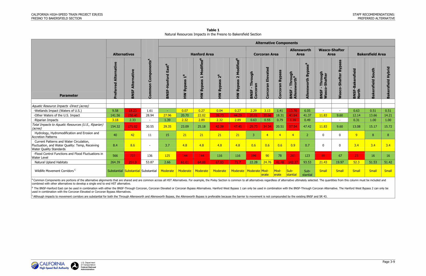
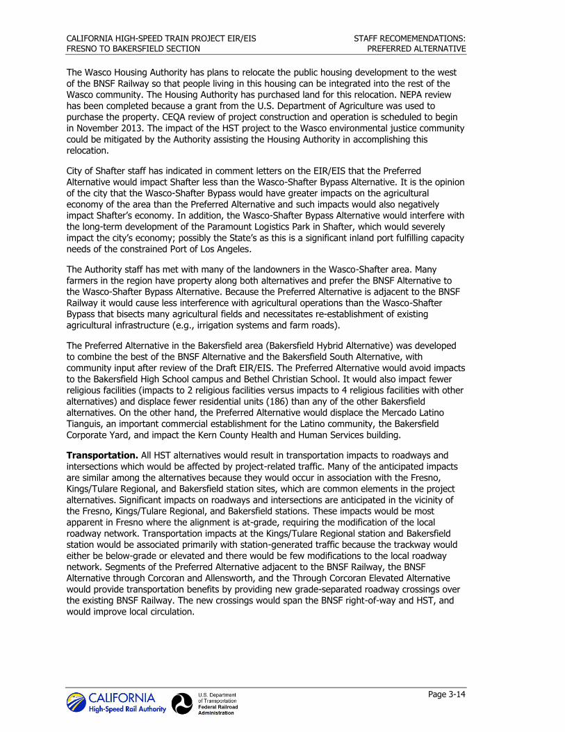
3.5 Alternatives Evaluation
3.5.1 Environmental Impacts
The Authority staff has balanced important environmental factors that differentiated the
alternatives, community preferences, and engineering considerations in recommending the Preferred Alternative. Generally, environmental issues identified are grouped into natural
resources impacts, community impacts (including transportation infrastructure), and effects
during construction. Table 1 summarizes impacts in each of these groupings. The color coding provided in Table 1 signifies a relative range of impacts that would be substantially higher
(represented by red), average (yellow), or substantially lower (green). The color codes offered the resource specialist a method of integrating a professional, qualitative judgment with the
quantity of impacts. For instance, when the quality of the resources affected varied more by habitat value than by acres, the color code reflects the value of impacts applied using
professional judgment rather than only quantities.
This evaluation provides information on the environmental topics where the alternatives are
substantively different and does not focus on resource topics where the potential impacts for the alternatives are substantially similar or were not significant, such as hydrology, air quality and
global climate change, public utilities and energy, geology, soils and seismicity, hazardous materials and waste, safety and security, electromagnetic fields and interference, station
planning, and archaeological and paleontological resources.
3.5.1.1 Natural Resources
Of all 108 possible combinations of HST alternatives, Table 1 demonstrates that the Preferred Alternative has one of the smallest impacts on natural resources, including high value resources
(e.g., natural land, vernal pools, conservation areas, and wildlife movement corridors). A short summary describing the relative differences of natural resource impacts follows for each category
of natural resources.
Special-Status Species. All alternatives would have a substantial effect on suitable habitat for
special-status species. Effects would either be direct during site preparation and construction or indirect through modified hydrology, noise, motion, startle, and ongoing facility operation. For
annual grasslands, natural habitats (i.e., valley foothill riparian, alkali desert scrub), and aquatic habitats, the Preferred Alternative would result in fewer acres of impact compared with most
other alternatives. The exceptions to this are in the Wasco-Shafter and Corcoran areas. The
Preferred Alternative would have a greater impact on man-made aquatic features in the Wasco-Shafter area than the Wasco-Shafter Bypass. For annual grassland, impacts of the Preferred
Alternative would be greater in the Corcoran area than alternatives that include the BNSF Alternative through Corcoran or the Corcoran Elevated Alternative. The BNSF and Corcoran
Elevated alternatives run through the urban areas of Corcoran and, in some instances, through annual grasslands adjacent to SR 43 and the BNSF Railway right-of-way, while the Corcoran
Bypass Alternative affects annual grasslands that would provide higher habitat value for special-
status species.
CALIFORNIA HIGH-SPEED TRAIN PROJECT EIR/EIS STAFF RECOMEMENDATIONS:
FRESNO TO BAKERSFIELD SECTION PREFERRED ALTERNATIVE
Page 3-9
Table 1 Natural Resources Impacts in the Fresno to Bakersfield Section
Parameter
Alternatives
Co
mm
on
Co
mp
on
en
tsA
Alternative Components
Hanford Area Corcoran Area
Allensworth
Area
Wasco-Shafter
Area Bakersfield Area
Pre
ferr
ed
Alt
ern
ati
ve
BN
SF A
lte
rna
tive
BN
SF-H
an
ford
Ea
stB
HW
Byp
ass 1
B
HW
Byp
ass 1
Mo
dif
ied
B
HW
Byp
ass 2
B
HW
Byp
ass 2
Mo
dif
ied
B
BN
SF -
Th
rou
gh
Co
rco
ran
Co
rco
ran
Ele
va
ted
Co
rco
ran
Byp
ass
BN
SF -
Th
rou
gh
All
en
sw
ort
hB
All
en
sw
ort
h B
yp
ass
B
BN
SF -
Th
rou
gh
Wa
sco
-Sh
aft
er
Wa
sco
-Sh
aft
er
By
pa
ss
BN
SF-B
ak
ers
fie
ld
No
rth
Ba
ke
rsfi
eld
So
uth
Ba
ke
rsfi
eld
Hy
bri
d
Aquatic Resource Impacts -Direct (acres)
◦Wetlands Impact (Waters of U.S.) 9.58 18.23 1.61 - 0.07 0.27 0.04 0.27 2.29 3.13 1.41 13.70 6.05 - - 0.63 0.51 0.51
◦Other Waters of the U.S. Impact 141.56 150.46 28.94 27.96 20.70 22.02 39.73 44.29 26.81 30.66 18.31 43.84 41.37 11.83 9.60 12.14 13.66 14.21
◦Riparian Impacts 3.18 2.33 - 1.39 2.32 2.89 2.32 2.89 0.63 0.55 0.79 1.39 0.49 - - 0.31 1.00 1.00
Total Impacts to Aquatic Resources (U.S., Riparian) (acres)
154.32 171.02 30.55 29.35 23.09 25.18 42.09 47.45 29.73 34.34 20.51 57.54 47.42 11.83 9.60 13.08 15.17 15.72
Hydrology, Hydromodification and Erosion and Accretion Patterns
40 42 11 15 21 21 21 21 3 4 4 4 2 0 0 9 8 8
Current Patterns and Water Circulation, Fluctuation, and Water Quality: Temp, Receiving Water Quality Standards
8.4 8.6 - 3.7 4.8 4.8 4.8 4.8 0.6 0.6 0.6 0.9 0.7 0 0 3.4 3.4 3.4
◦Flood Control Functions and Flood Fluctuations in Water Level
566 722 136 125 144 144 116 116 199 90 78 201 123 88 67 23 16 16
Natural Upland Habitats 264.39 294.9 53.87 2.66 61.01 64.88 67.83 71.7 22.28 24.76 41.48 142.37 93.53 21.43 19.97 52.3 51.53 51.42
Wildlife Movement Corridors C Substantial Substantial Substantial Moderate Moderate Moderate Moderate Moderate Moderate Mod-erate
Mod-erate
Sub-stantial
Sub-stantial
Small Small Small Small Small
A Common Components are portions of the alternative alignments that are shared and are common across all HST Alternatives. For example, the Pixley Section is common to all alternatives regardless of alternative ultimately selected. The quantities from this column must be included and combined with other alternatives to develop a single end to end HST alternative.
B The BNSF-Hanford East can be used in combination with either the BNSF-Through Corcoran, Corcoran Elevated or Corcoran Bypass Alternatives. Hanford West Bypass 1 can only be used in combination with the BNSF-Through Corcoran Alternative. The Hanford West Bypass 2 can only be used in combination with the Corcoran Elevated or Corcoran Bypass Alternatives.
C Although impacts to movement corridors are substantial for both the Through Allensworth and Allensworth Bypass, the Allensworth Bypass is preferable because the barrier to movement is not compounded by the existing BNSF and SR 43.
CALIFORNIA HIGH-SPEED TRAIN PROJECT EIR/EIS STAFF RECOMEMENDATIONS:
FRESNO TO BAKERSFIELD SECTION PREFERRED ALTERNATIVE
Page 3-10
This page intentionally left blank
CALIFORNIA HIGH-SPEED TRAIN PROJECT EIR/EIS STAFF RECOMEMENDATIONS:
FRESNO TO BAKERSFIELD SECTION PREFERRED ALTERNATIVE
Page 3-11
Waters of the U.S. All of the alternatives would have substantial impacts on waters of the U.S.
(aquatic communities). Excellent-condition waters of the U.S. only exist in the Allensworth area (Upper Deer–Upper White Watershed), and even there they only exist in small quantities. The
Allensworth area also has more acreage of waters under the jurisdiction of the USACE, including those in good condition (vernal pools and swales, Deer Creek, and Poso Creek), than any of the
other geographic areas. The Bakersfield and Hanford areas also contain good-condition aquatic
resources, primarily associated with the King River Complex, seasonal wetlands, and the Kern River. All of the impacted features in the Wasco-Shafter area are in poor existing condition, and
are manmade for agricultural uses (e.g., detention basins and irrigation canals).
The Preferred Alternative minimizes impacts on waters of the U.S. compared with all other available HST alternatives except in the Hanford and Wasco-Shafter areas. In the Hanford area,
the Preferred Alternative is the only alternative that would not impact wetlands. Wetlands are a category of waters of the U.S. that constitute sensitive habitats and were identified in the
detailed analysis of condition among the highest scoring (best quality) features in the entire
study area. The Preferred Alternative would impact more acres of other waters of the U.S. (e.g., seasonal riverine habitat, canals, and irrigation ditches) when compared to the Hanford West 1
Bypass alternatives that connect to the BNSF Alternative through Corcoran south of Hanford. However, the Preferred Alternative through the Hanford and Corcoran areas would impact fewer
acres of waters of the U.S. than any other alternative alignment combinations through these two geographic areas (i.e., Hanford West Bypass 1 alternatives and BNSF through Corcoran and
Hanford West Bypass 2 alternatives and Through Corcoran Elevated or Corcoran Bypass).
The Preferred Alternative in the Wasco and Shafter area (BNSF Alternative through Wasco and
Shafter) impacts almost twice the acreage of habitat classified as jurisdictional waters of the U.S. for the purpose of this analysis as the Wasco-Shafter Bypass Alternative. None of these waters
are wetlands. All of the waters consist of manmade features installed in uplands for agricultural purposes such as irrigation return flow detention basins and irrigation canals. All of these waters
are in poor condition for aquatic habitat. All of the functions and services provided by these aquatic features can be restored by rerouting canals and ditches or creating additional capacity in
detention basins.
Riparian Habitat. Riparian communities include narrow bands of “valley and foothill” riparian
vegetation adjacent to seasonal riverine features found throughout the study area. These plant communities include all vegetated portions of the channel from the median high-water mark to
the outer edges of the watercourses. Riparian habitat is frequently used as linear dispersal corridors that funnel wildlife movement through an otherwise fragmented landscape. Because
these features are oriented in an east-west fashion and the project has a north-south orientation,
all HST alternatives are required to cross the drainages and the associated riparian communities. The range of acreages representative of the direct and indirect effect is similar through all HST
alternatives. The Preferred Alternative has the least impact to riparian habitat except in the Corcoran and Bakersfield areas where it impacts slightly more riparian habitat than the BNSF
through Corcoran and Bakersfield North (BNSF) alternatives.
Conservation Areas. The Preferred Alternative would not adversely impact conservation areas. On the other hand, the BNSF Alternative in Allensworth would have some significant impacts on
Allensworth Ecological Reserve. The BNSF Alternative in the Allensworth area would parallel the
BNSF track and SR43 and impact Allensworth Ecological Reserve, whereas the Preferred Alternative in this area would occur west of this conservation area. The Allensworth Ecological
Reserve is managed by the California Department of Fish and Wildlife and provides habitat for a number of special-status plant and wildlife species including the San Joaquin kit fox, blunt-nosed
leopard lizard, Tipton kangaroo rat, western burrowing owl, Swainson’s hawk, and vernal pool fairy shrimp. Project impacts on the ecological reserve would require extensive mitigation and
CALIFORNIA HIGH-SPEED TRAIN PROJECT EIR/EIS STAFF RECOMEMENDATIONS:
FRESNO TO BAKERSFIELD SECTION PREFERRED ALTERNATIVE
Page 3-12
agency negotiations to offset direct and indirect effects. By avoiding impacts to this conservation
area, the Preferred Alternative would significantly reduce mitigation requirements.
Each of the alternatives would occur within the Metropolitan Bakersfield Habitat Conservation Plan; however, these impacts are less than significant and do not affect targeted conservation
areas.
Wildlife Corridors. Although all HST alternatives would present a barrier to wildlife crossing, the project incorporates a number of engineering design features to provide permeability to
wildlife, including the installation of dedicated wildlife movement structures. The existing landscape has been fragmented through urban, transportation, and agriculture land uses that
significantly restrict wildlife movement; however, several movement linkages have been identified
including areas along the Kings River complex, Cross Creek, Deer Creek, Sand Ridge (Allensworth area), Poso Creek, and the Kern River. Because the project design is similar across most of the
rivers and creeks where wildlife movement occurs, the impacts are similar among HST alternatives. However, the Preferred Alternative in the Allensworth area would create a new
restriction to wildlife movement in the Sand Ridge area. The Preferred Alternative has some slight advantages over the BNSF Alternative in the Allensworth area in that while it would create a new
barrier, it would not have the compounding effects that are associated with the BNSF Alternative.
These compounding effects occur because not only would the alternative create a new barrier but it would also be constructed adjacent to the existing barriers associated with the BNSF tracks
and SR 43. Wildlife crossing opportunities are provided through the use of viaducts, bridges, road over and under crossings, drainage facilities (large culverts), and dedicated wildlife movement
structures.
3.5.2 Section 4(f) Uses
Section 4(f) of the Department of Transportation Act (49 U.S.C. 303) provides special protection
to publicly-owned public parks, recreational areas of national, state or local significance, wildlife or waterfowl refuges, and lands from a historic site of national, state or local significance. Section
4(f) properties can only be used for federal-funded transportation projects if there is no feasible and prudent alternative and all possible planning has been taken to avoid the use of a 4(f)
property or to minimize harm to any 4(f) property affected by the project. All alternatives cross three historic irrigation canals in southern Fresno County that cannot be avoided by feasible and
prudent alternatives. The BNSF Alternative in the Hanford area and the Hanford West Bypass
alternatives each use an historic canal that cannot be avoided by feasible and prudent alternatives. None of the alternatives in the Corcoran and Wasco-Shafter areas use 4(f)
properties. The BNSF Alternative in the Allensworth area uses two 4(f) properties: Colonel Allensworth State Historic Park and Allensworth Ecological Reserve. The Allensworth Bypass
Alternative avoids both of these properties. The Bakersfield South Alternative would use an
historic farmstead.
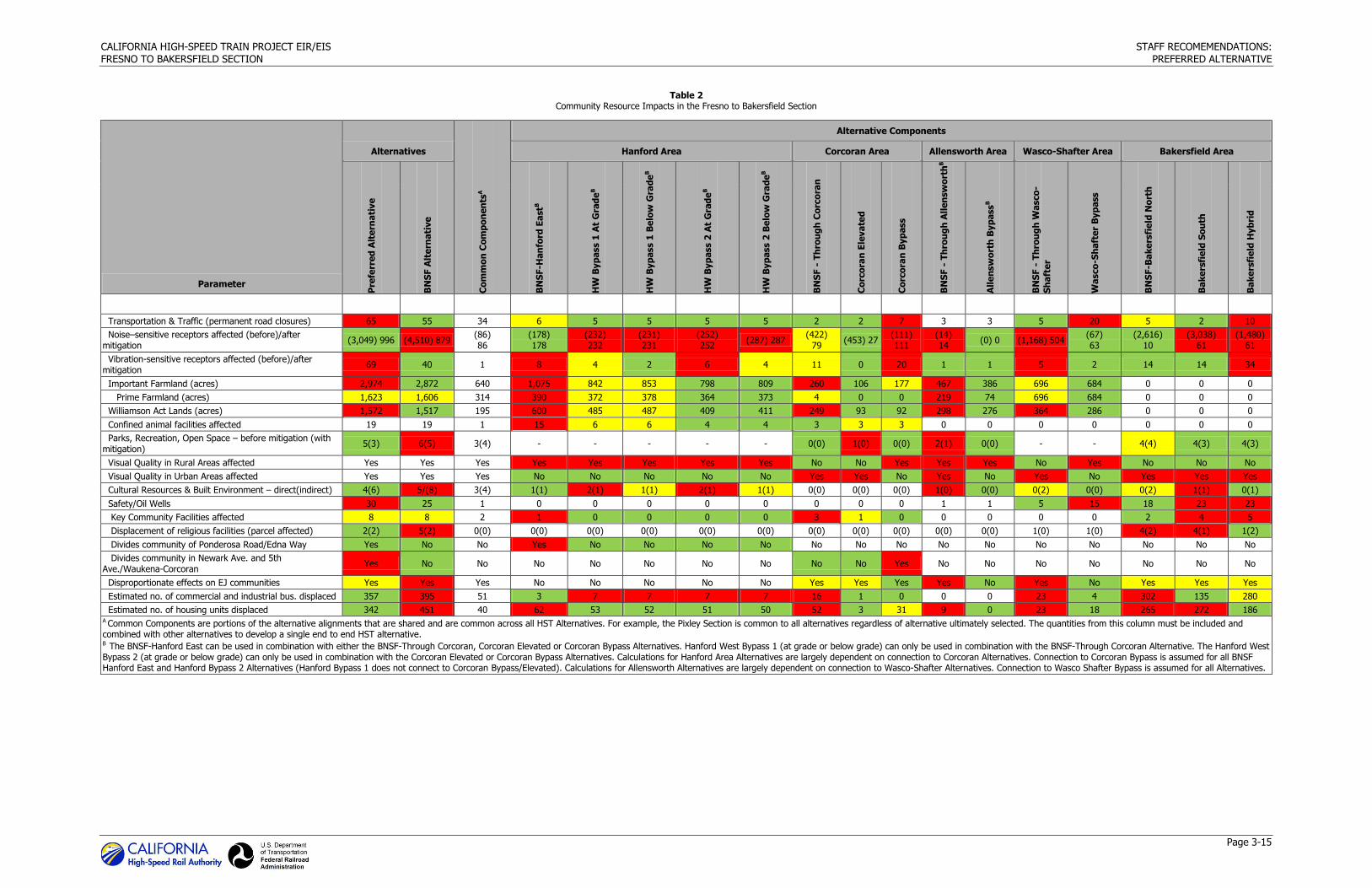
3.5.3 Community Resources and Land Use
Community Effects. Except for Fresno with a single alternative and Bakersfield with three through-town alternatives, differentiators among the alternatives are related to effects on the
communities of Hanford, Corcoran, Allensworth, Wasco, and Shafter. In Hanford, the Preferred Alternative would lie within the city’s secondary Sphere of Influence (SOI) which is east of SR 43.
The Preferred Alternative would result in greater impacts to farmland and confined animal facilities than the Hanford West Bypass alternatives. The Preferred Alternative would also divide
the existing rural residential neighborhood at Ponderosa Road and Edna Way, whereas the
Hanford West Bypass alternatives would interfere with the residential development planned in the Live Oak Master Plan. This Master Plan has been approved by the City of Hanford but
development has not begun because of current economic conditions.
CALIFORNIA HIGH-SPEED TRAIN PROJECT EIR/EIS STAFF RECOMEMENDATIONS:
FRESNO TO BAKERSFIELD SECTION PREFERRED ALTERNATIVE
Page 3-13
Hanford envisions strong commercial development on the eastern edge of the city. In 2012, the
city issued a Notice of Preparation/Initial Study to amend the Hanford General Plan for a 58-acre site in the northwest quadrant of the SR 43/SR 198 interchange to facilitate the ultimate
development of about 500,000 square feet of commercial buildings and up to 200 apartment units. Costco plans to build a 150,000 square foot store in this area which will anchor the
commercial development. The Draft EIR for the General Plan amendment was released by the
City of Hanford on October 1, 2013. An HST station close to the northeast quadrant of the SR 43/SR 198 interchange would enhance connectivity and encourage growth where Hanford is
planning for it.
In Corcoran and Allensworth, the Preferred Alternative incorporates bypass alternatives, avoiding substantial displacement and environmental justice impacts, and still having fewer impacts on
Important Farmlands than the BNSF Alternative that goes through these communities.
In the Wasco-Shafter area, the Preferred Alternative follows the BNSF Railway through Wasco and Shafter. As shown in Table 2, the Preferred Alternative results in more residential and
commercial displacements than the Wasco-Shafter Bypass Alternative. It would cross the principal industrial/commercial center of Wasco displacing three businesses including the
SUNNYGEM nut processing facility and Thermo Trilogy Corporation’s biopesticide manufacturing
plant. The Preferred Alternative would also result in a substantial noise impact to a public housing development owned and operated by the Wasco Housing Authority east of the HST alignment, as
well as reinforcing the feeling of isolation this community has from the rest of Wasco. Finally, the Preferred Alternative would have substantially less cost uncertainty than the Wasco-Shafter
Bypass Alternative because there are fewer active and abandoned oil wells along the Preferred
Alternative than the Wasco-Shafter Bypass Alternative.
It is the Authority’s policy that active oil and gas wells within 200 feet of the HST tracks will be
plugged and relocated and inactive wells will be examined and reabandoned, as necessary. The
cost of relocating active wells is uncertain. Well installation typically involves optimizing the entrance to the target oil recovery zone. Therefore, capping an existing well and redrilling into
the target zone from a nearby location may not result in the same level of production from the new well. The production rate from a new well cannot be estimated before it is installed.
Consequently, replacing wells may result in a reduction in the rate of production from the new
wells. The Authority would be responsible for reimbursing the well owner for this loss in production. The California Department of Conservation, Division of Oil, Gas and Geothermal
Resources (DOGGR) has also recommended against construction of any structures over capped oil wells due to the potential of oil well leakage, though it is not a strict regulatory requirement. If
leakage were detected in abandoned wells within 200 feet of the HST tracks, it could disrupt rail
operations for an extended period of time to stop the leak and do clean-up work. There are probably engineering solutions to recapping of wells that should preclude the shutdown of train
operations, but would likely potentially add to the operating costs of the HST System.
The Wasco-Shafter Bypass Alternative passes roughly through the center of the North Shafter Oil Field. This field is still being developed. As of early 2013, there were 16 wells within the 200-foot
safety zone of the Wasco-Shafter Bypass Alternative, 2 of which are also included in the Preferred Alternative alignment. Four of the wells on the Wasco-Shafter Bypass are inactive, one
of which is plugged, and the remaining 12 are active oil wells. On the preferred alignment
through Wasco and Shafter, there are four wells, one is a potentially active oil well, one an active salt water disposal well, and two are inactive wells, one of which is plugged. Because of the
uncertainty in the cost of moving active wells and the long-term operational interference that could occur with abandoned wells that eventually leak, the Wasco-Shafter Alternative has much
greater uncertainty in its cost than the Preferred Alternative.
CALIFORNIA HIGH-SPEED TRAIN PROJECT EIR/EIS STAFF RECOMEMENDATIONS:
FRESNO TO BAKERSFIELD SECTION PREFERRED ALTERNATIVE
Page 3-14
The Wasco Housing Authority has plans to relocate the public housing development to the west
of the BNSF Railway so that people living in this housing can be integrated into the rest of the Wasco community. The Housing Authority has purchased land for this relocation. NEPA review
has been completed because a grant from the U.S. Department of Agriculture was used to purchase the property. CEQA review of project construction and operation is scheduled to begin
in November 2013. The impact of the HST project to the Wasco environmental justice community
could be mitigated by the Authority assisting the Housing Authority in accomplishing this relocation.
City of Shafter staff has indicated in comment letters on the EIR/EIS that the Preferred
Alternative would impact Shafter less than the Wasco-Shafter Bypass Alternative. It is the opinion of the city that the Wasco-Shafter Bypass would have greater impacts on the agricultural
economy of the area than the Preferred Alternative and such impacts would also negatively impact Shafter’s economy. In addition, the Wasco-Shafter Bypass Alternative would interfere with
the long-term development of the Paramount Logistics Park in Shafter, which would severely
impact the city’s economy; possibly the State’s as this is a significant inland port fulfilling capacity needs of the constrained Port of Los Angeles.
The Authority staff has met with many of the landowners in the Wasco-Shafter area. Many
farmers in the region have property along both alternatives and prefer the BNSF Alternative to the Wasco-Shafter Bypass Alternative. Because the Preferred Alternative is adjacent to the BNSF
Railway it would cause less interference with agricultural operations than the Wasco-Shafter Bypass that bisects many agricultural fields and necessitates re-establishment of existing
agricultural infrastructure (e.g., irrigation systems and farm roads).
The Preferred Alternative in the Bakersfield area (Bakersfield Hybrid Alternative) was developed to combine the best of the BNSF Alternative and the Bakersfield South Alternative, with
community input after review of the Draft EIR/EIS. The Preferred Alternative would avoid impacts
to the Bakersfield High School campus and Bethel Christian School. It would also impact fewer religious facilities (impacts to 2 religious facilities versus impacts to 4 religious facilities with other
alternatives) and displace fewer residential units (186) than any of the other Bakersfield alternatives. On the other hand, the Preferred Alternative would displace the Mercado Latino
Tianguis, an important commercial establishment for the Latino community, the Bakersfield
Corporate Yard, and impact the Kern County Health and Human Services building.
Transportation. All HST alternatives would result in transportation impacts to roadways and
intersections which would be affected by project-related traffic. Many of the anticipated impacts
are similar among the alternatives because they would occur in association with the Fresno, Kings/Tulare Regional, and Bakersfield station sites, which are common elements in the project
alternatives. Significant impacts on roadways and intersections are anticipated in the vicinity of the Fresno, Kings/Tulare Regional, and Bakersfield stations. These impacts would be most
apparent in Fresno where the alignment is at-grade, requiring the modification of the local
roadway network. Transportation impacts at the Kings/Tulare Regional station and Bakersfield station would be associated primarily with station-generated traffic because the trackway would
either be below-grade or elevated and there would be few modifications to the local roadway network. Segments of the Preferred Alternative adjacent to the BNSF Railway, the BNSF
Alternative through Corcoran and Allensworth, and the Through Corcoran Elevated Alternative
would provide transportation benefits by providing new grade-separated roadway crossings over the existing BNSF Railway. The new crossings would span the BNSF right-of-way and HST, and
would improve local circulation.
CALIFORNIA HIGH-SPEED TRAIN PROJECT EIR/EIS STAFF RECOMEMENDATIONS:
FRESNO TO BAKERSFIELD SECTION PREFERRED ALTERNATIVE
Page 3-15
Table 2 Community Resource Impacts in the Fresno to Bakersfield Section
Parameter
Alternatives
Co
mm
on
Co
mp
on
en
tsA
Alternative Components
Hanford Area Corcoran Area Allensworth Area Wasco-Shafter Area Bakersfield Area
Pre
ferr
ed
Alt
ern
ati
ve
BN
SF A
lte
rna
tive
BN
SF
-Han
ford
Ea
stB
HW
Byp
ass 1
At
Gra
de
B
HW
Byp
ass 1
Be
low
Gra
de
B
HW
Byp
ass 2
At
Gra
de
B
HW
Byp
ass 2
Be
low
Gra
de
B
BN
SF -
Th
rou
gh
Co
rco
ran
Co
rco
ran
Ele
va
ted
Co
rco
ran
Byp
ass
BN
SF -
Th
rou
gh
All
en
sw
ort
hB
All
en
sw
ort
h B
yp
ass
B
BN
SF -
Th
rou
gh
Wasco
-
Sh
aft
er
Wa
sco
-Sh
aft
er
Byp
ass
BN
SF
-Ba
ke
rsfi
eld
No
rth
Ba
ke
rsfi
eld
So
uth
Ba
ke
rsfi
eld
Hyb
rid
Transportation & Traffic (permanent road closures) 65 55 34 6 5 5 5 5 2 2 7 3 3 5 20 5 2 10
Noise–sensitive receptors affected (before)/after mitigation
(3,049) 996 (4,510) 879 (86) 86
(178) 178
(232) 232
(231) 231
(252) 252
(287) 287 (422)
79 (453) 27
(111) 111
(14) 14
(0) 0 (1,168) 504 (67) 63
(2,616) 10
(3,038) 61
(1,480) 61
Vibration-sensitive receptors affected (before)/after mitigation
69 40 1 8 4 2 6 4 11 0 20 1 1 5 2 14 14 34
Important Farmland (acres) 2,974 2,872 640 1,075 842 853 798 809 260 106 177 467 386 696 684 0 0 0
Prime Farmland (acres) 1,623 1,606 314 390 372 378 364 373 4 0 0 219 74 696 684 0 0 0
Williamson Act Lands (acres) 1,572 1,517 195 600 485 487 409 411 249 93 92 298 276 364 286 0 0 0
Confined animal facilities affected 19 19 1 15 6 6 4 4 3 3 3 0 0 0 0 0 0 0
Parks, Recreation, Open Space – before mitigation (with mitigation)
5(3) 6(5) 3(4) - - - - - 0(0) 1(0) 0(0) 2(1) 0(0) - - 4(4) 4(3) 4(3)
Visual Quality in Rural Areas affected Yes Yes Yes Yes Yes Yes Yes Yes No No Yes Yes Yes No Yes No No No
Visual Quality in Urban Areas affected Yes Yes Yes No No No No No Yes Yes No Yes No Yes No Yes Yes Yes
Cultural Resources & Built Environment – direct(indirect) 4(6) 5/(8) 3(4) 1(1) 2(1) 1(1) 2(1) 1(1) 0(0) 0(0) 0(0) 1(0) 0(0) 0(2) 0(0) 0(2) 1(1) 0(1)
Safety/Oil Wells 30 25 1 0 0 0 0 0 0 0 0 1 1 5 15 18 23 23
Key Community Facilities affected 8 8 2 1 0 0 0 0 3 1 0 0 0 0 0 2 4 5
Displacement of religious facilities (parcel affected) 2(2) 5(2) 0(0) 0(0) 0(0) 0(0) 0(0) 0(0) 0(0) 0(0) 0(0) 0(0) 0(0) 1(0) 1(0) 4(2) 4(1) 1(2)
Divides community of Ponderosa Road/Edna Way Yes No No Yes No No No No No No No No No No No No No No
Divides community in Newark Ave. and 5th Ave./Waukena-Corcoran
Yes No No No No No No No No No Yes No No No No No No No
Disproportionate effects on EJ communities Yes Yes Yes No No No No No Yes Yes Yes Yes No Yes No Yes Yes Yes
Estimated no. of commercial and industrial bus. displaced 357 395 51 3 7 7 7 7 16 1 0 0 0 23 4 302 135 280
Estimated no. of housing units displaced 342 451 40 62 53 52 51 50 52 3 31 9 0 23 18 265 272 186 A Common Components are portions of the alternative alignments that are shared and are common across all HST Alternatives. For example, the Pixley Section is common to all alternatives regardless of alternative ultimately selected. The quantities from this column must be included and combined with other alternatives to develop a single end to end HST alternative. B The BNSF-Hanford East can be used in combination with either the BNSF-Through Corcoran, Corcoran Elevated or Corcoran Bypass Alternatives. Hanford West Bypass 1 (at grade or below grade) can only be used in combination with the BNSF-Through Corcoran Alternative. The Hanford West Bypass 2 (at grade or below grade) can only be used in combination with the Corcoran Elevated or Corcoran Bypass Alternatives. Calculations for Hanford Area Alternatives are largely dependent on connection to Corcoran Alternatives. Connection to Corcoran Bypass is assumed for all BNSF Hanford East and Hanford Bypass 2 Alternatives (Hanford Bypass 1 does not connect to Corcoran Bypass/Elevated). Calculations for Allensworth Alternatives are largely dependent on connection to Wasco-Shafter Alternatives. Connection to Wasco Shafter Bypass is assumed for all Alternatives.

CALIFORNIA HIGH-SPEED TRAIN PROJECT EIR/EIS STAFF RECOMEMENDATIONS:
FRESNO TO BAKERSFIELD SECTION PREFERRED ALTERNATIVE
Page 3-16
This page intentionally left blank

CALIFORNIA HIGH-SPEED TRAIN PROJECT EIR/EIS STAFF RECOMEMENDATIONS:
FRESNO TO BAKERSFIELD SECTION PREFERRED ALTERNATIVE
Page 3-17
Noise. All HST alternatives would have noise impacts. Impacts from noise are expected to occur
throughout the alignment, with both urban and rural residences expected to experience significant noise impacts. The Preferred Alternative would impact 3,049 sensitive receivers
(residences, churches, schools, hospitals, parks, and historic properties) before mitigation. With implementation of sound walls, the Preferred Alternative would severely impact 966 noise
receivers.
The Preferred Alternative would have the least impact to sensitive receivers than other alternatives in the Hanford and Allensworth areas. In Corcoran, the BNSF and Corcoran Elevated
alternatives would impact more receivers before mitigation, but after the implementation of
sound walls, the Preferred Alternative (Corcoran Bypass Alternative) would have the greatest impacts because mitigation in agricultural areas would not be effective or would be extremely
costly. The Preferred Alternative in the Wasco-Shafter area would affect more sensitive receivers than the rural Wasco-Shafter Bypass Alternative. In Bakersfield, both the Preferred Alternative
(Bakersfield Hybrid Alternative) and the Bakersfield South Alternative would impact the same
number of receivers, with the BNSF Alternative impacting the fewest number of receivers.
Agricultural Land Conversion. All alternatives would have significant impacts on agricultural
land that cannot be mitigated to a level of less-than-significant. Alternatives that do not follow an
existing transportation corridor would sever more farm and ranch parcels than alternatives that closely follow existing transportation corridors.
The Preferred Alternative would require crossing and potentially severing fewer farmlands and
dairies in the Allensworth and Wasco-Shafter areas. The Preferred Alternative in the Hanford area would permanently convert more acres of Important Farmland and Williamson Act lands than the
Hanford West Bypass alternatives, while also impacting a greater number of confined animal facilities. The Preferred Alternative in the Corcoran area (Corcoran Bypass Alternative) would
permanently impact more Important Farmland than the Corcoran Elevated Alternative but less
than the BNSF Alternative. The Preferred Alternative would affect the least amount of Williamson Act lands of all the Corcoran alternatives. In the Wasco-Shafter area, the Preferred Alternative
would permanently impact approximately the same acreage of Important Farmland as the Wasco-Shafter Bypass and fewer acres of Williamson Act lands than the Wasco-Shafter Bypass.
Parks. All HST alternatives would affect park resources. The Preferred Alternative would affect
fewer parks, recreational, and open-space areas than the other possible project alternatives. The Corcoran Elevated Alternative would affect one park. All project alternatives would affect four
recreation areas in Bakersfield: Kern River Parkway, Mill Creek Linear Park, Bakersfield Amtrak
Station Playground, and the McMurtry Aquatic Park. The BNSF Alternative in the Allensworth area would significantly impact the Allensworth State Historic Park with parkland acquisition and with
the introduction of a modern feature into the historic atmosphere of the park, and the Allensworth Ecological Reserve land acquisition.
Visual Resources. Visual resources, such as viewsheds and aesthetic corridors, cross over both
urban and rural landscapes. Visual resources, such as vistas and aesthetic corridors, exist in both
urban and rural landscapes. Significant impacts on vistas and aesthetic corridors are primarily expected to result from the vertical elements of the HST alternatives, particularly when elevated,
because those vertical segments will block views of visual resources and change the landscape character. All alternatives could cause visual intrusion and potential for blocking of views from the
use of sound barriers where these are required, usually in urban areas.
Cultural Resources. All HST alternatives would affect cultural resources. The Preferred Alternative would directly affect 4 Section 106 historic properties and indirectly affect 6 Section
106 historic properties. The Preferred Alternative would impact fewer Section 106 historic
properties than any project alternative except in the Wasco-Shafter area where the Preferred
CALIFORNIA HIGH-SPEED TRAIN PROJECT EIR/EIS STAFF RECOMEMENDATIONS:
FRESNO TO BAKERSFIELD SECTION PREFERRED ALTERNATIVE
Page 3-18
Alternative would have indirect visual impacts on the Santa Fe Deport and San Francisco & San
Joaquin Valley Railroad Section House in Shafter.
3.5.3.1 Community Impacts by Individual Geographic Alternative
Hanford. In the Hanford area, the Preferred Alternative (BNSF Alternative) would have severe
noise impacts on fewer sensitive receivers, impact more acres of Important Farmlands and
Williamson Act lands, and impact more confined animal facilities than the Hanford West Bypass alternatives. The Preferred Alternative would also displace some Baker Commodities facilities, an
animal carcass processing plant critical to the dairy business in the region, and divide the community at Ponderosa Road and Edna Way. Impacts to Baker Commodities can be mitigated
within that company’s current property boundaries. There would be slightly more residential
displacements and slightly fewer commercial displacements under the Preferred Alternative than under the Hanford West Bypass alternatives. The Preferred Alternative and the Hanford West
Bypass alternatives would each use one Section 4(f) property. The Preferred Alternative would be more consistent with Hanford’s vision of its future development than the Hanford West Bypass
alternatives. The Preferred Alternative would also be consistent with Visalia’s desires for future transportation opportunities for its citizens.
Corcoran. In the Corcoran area, the Preferred Alternative (Corcoran Bypass) would have severe
noise impacts on more receptors than the BNSF Alternative or the Corcoran Elevated Alternative;
fewer impacts on Important Farmlands than the BNSF Alternative; and greater impacts on Important Farmlands than the Corcoran Elevated Alternative. It would have the fewest impacts
on Williamson Act lands of all Corcoran area alternatives. Similar to the Corcoran Elevated Alternative, the Preferred Alternative would have fewer impacts on confined animal facilities than
would the BNSF Alternative. No key community facilities or churches would be affected under the Preferred Alternative, unlike the BNSF and Corcoran Elevated alternatives. The Preferred
Alternative may divide and affect the small, unincorporated, rural residential community in the
vicinity of Newark Avenue, between SR 43 and the irrigation canal, as well as the smaller enclave of rural residential homes in the vicinity of 5th Avenue and Waukena Avenue. The Preferred
Alternative would have fewer residential displacements than the BNSF Alternative in the Corcoran area, and more than the Corcoran Elevated Alternative. Preferred Alternative is the only
alternative in the Corcoran area with no industrial/commercial displacements. No Section 4(f)
properties would be used under any of the Corcoran alternatives.
Allensworth. In the Allensworth area, the Preferred Allensworth Alternative (Allensworth Bypass
Alternative) would have no severe impacts on noise receptors following mitigation, unlike the
BNSF Alternative. The Preferred Alternative would affect fewer acres of Important Farmlands and Williamson Act lands. No confined animal facilities, key community facilities, or churches would
be affected by either alternative. Unlike the BNSF Alternative, the Preferred Alternative in the Allensworth area would not affect an environmental justice community. No residential
displacements would occur under the Preferred Alternative; 9 would occur under the BNSF
Alternative; no commercial displacements would occur under either alternative. No Section 4(f) properties would be used under the Preferred Alternative, while there would be a use of two
Section 4(f) properties under the BNSF Alternative. One historic property would also be affected by the BNSF Alternative in the Allensworth area.
Wasco-Shafter. In the Wasco-Shafter area, the Preferred Alternative (BNSF Alternative) would
have severe noise impacts following mitigation on substantially more receptors than the Wasco-Shafter Bypass Alternative. Both alternatives would affect about the same acreage Important
Farmland but the Preferred Alternative would impact more Williamson Act lands. No confined
animal facilities, key community facilities, or churches would be affected by either alternative. Depending on the timing of the relocation of the public housing development, the Preferred
Alternative may not affect an environmental justice community. If the City of Wasco relocates the
CALIFORNIA HIGH-SPEED TRAIN PROJECT EIR/EIS STAFF RECOMEMENDATIONS:
FRESNO TO BAKERSFIELD SECTION PREFERRED ALTERNATIVE
Page 3-19
residents of the public housing development into the new housing development before
construction of the HST project, then significant noise impacts and community division would be avoided. Meanwhile, mitigation measures have been identified to reduce impacts. There would be
more commercial/industrial displacements and more residential relocations under the Preferred Alternative. No Section 4(f) properties would be used under either of the alternatives in the
Wasco-Shafter area.
The City of Shafter has stated its preference for the Preferred Alternative instead of the Wasco-Shafter Bypass. In addition, landowners in the region, many of whom own property on both
alternatives, have stated a preference for the BNSF Alternative through Wasco and Shafter rather
than the Wasco-Shafter Bypass.
Bakersfield. In the Bakersfield area, the Preferred Alternative (Bakersfield Hybrid Alternative) would have similar severe noise impacts following mitigation as the Bakersfield South Alternative
and more than the BNSF Alternative. None of the Bakersfield alternatives would impact Important Farmlands, Williamson Act or confined animal facilities. The Preferred Alternative would displace
more key community facilities but fewer churches than the other alternatives in Bakersfield, and would not impact the Bakersfield High School campus. No community division would occur under
any of the Bakersfield alternatives, and all alternatives would affect environmental justice
communities. The Preferred Alternative would have the fewest residential displacements of all Bakersfield alternatives, fewer commercial/industrial displacements than the BNSF Alternative,
and more commercial/industrial displacements than the Bakersfield South Alternative. The Preferred Alternative and the BNSF Alternative would not use any Section 4(f) properties, while
the Bakersfield South Alternative would use one Section 4(f) property; avoidance of the Section
4(f) property at 2905 California Street was explored but was determined to have greater environmental effects. The Preferred Alternative would be approximately 1 minute slower than
the BNSF and Bakersfield South alternatives, plus an additional minute that would be required for the Bakersfield to Palmdale HST Section. This is outweighed by fewer Section 4(f) uses than the
Bakersfield South Alternative and reduced community impacts. The Preferred Alternative was derived from input received from the community in response to the information in the Draft
EIR/EIS, especially related to avoidance of churches in Bakersfield.
3.5.4 Capital Costs
The Preferred Alternative is estimated to cost approximately $7.174 billion (in 2010 dollars). The
Preferred Alternative would have substantially lower capital costs than the BNSF Alternative which is estimated at $7.613 billion. The alternative with the lowest capital cost at $6.822 billion
consists of segments of the BNSF Alternative in combination with the Hanford West Bypass 2, Corcoran Bypass, Allensworth Bypass, Wasco-Shafter Bypass, and Bakersfield South alternatives.
All alternatives with the Corcoran Bypass, Allensworth Bypass, and Wasco-Shafter Bypass are less
expensive than alternatives that do not include these bypasses because the bypasses have less elevated structure.
3.5.5 Constructability Issues
Perched groundwater is locally present west of the city of Hanford in the vicinity of the Hanford
West Bypass alternatives. Construction of a below-grade station on the Hanford West Bypass alternatives would be affected by this condition. If a perched water zone is present at the below-
grade alignment cut and station sites, it would be necessary either to install a water collection and management system; seal the excavation with concrete, which would be prohibitively
expensive; or raise the elevation of the alignment and station above the shallow saturated zone.
Raising the elevation of the alignment and station could reduce or eliminate the noise and visual benefits of a below-grade alternative.
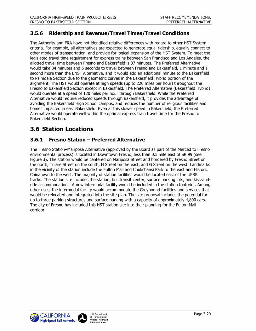
CALIFORNIA HIGH-SPEED TRAIN PROJECT EIR/EIS STAFF RECOMEMENDATIONS:
FRESNO TO BAKERSFIELD SECTION PREFERRED ALTERNATIVE
Page 3-20
3.5.6 Ridership and Revenue/Travel Times/Travel Conditions
The Authority and FRA have not identified relative differences with regard to other HST System
criteria. For example, all alternatives are expected to generate equal ridership, equally connect to other modes of transportation, and provide for logical expansion of the HST System. To meet the
legislated travel time requirement for express trains between San Francisco and Los Angeles, the allotted travel time between Fresno and Bakersfield is 37 minutes. The Preferred Alternative
would take 34 minutes and 5 seconds to travel between Fresno and Bakersfield, 1 minute and 1
second more than the BNSF Alternative, and it would add an additional minute to the Bakersfield to Palmdale Section due to the geometric curves in the Bakersfield Hybrid portion of the
alignment. The HST would operate at high speeds (up to 220 miles per hour) throughout the Fresno to Bakersfield Section except in Bakersfield. The Preferred Alternative (Bakersfield Hybrid)
would operate at a speed of 120 miles per hour through Bakersfield. While the Preferred Alternative would require reduced speeds through Bakersfield, it provides the advantage of
avoiding the Bakersfield High School campus, and reduces the number of religious facilities and
homes impacted in east Bakersfield. Even at this slower speed in Bakersfield, the Preferred Alternative would operate well within the optimal express train travel time for the Fresno to
Bakersfield Section.
3.6 Station Locations
3.6.1 Fresno Station – Preferred Alternative
The Fresno Station–Mariposa Alternative (approved by the Board as part of the Merced to Fresno
environmental process) is located in Downtown Fresno, less than 0.5 mile east of SR 99 (see Figure 3). The station would be centered on Mariposa Street and bordered by Fresno Street on
the north, Tulare Street on the south, H Street on the east, and G Street on the west. Landmarks in the vicinity of the station include the Fulton Mall and Chukchansi Park to the east and Historic
Chinatown to the west. The majority of station facilities would be located east of the UPRR tracks. The station site includes the station, bus transit center, surface parking lots, and kiss-and-
ride accommodations. A new intermodal facility would be included in the station footprint. Among
other uses, the intermodal facility would accommodate the Greyhound facilities and services that would be relocated and integrated into the site plan. The site proposal includes the potential for
up to three parking structures and surface parking with a capacity of approximately 4,800 cars. The city of Fresno has included this HST station site into their planning for the Fulton Mall
corridor.
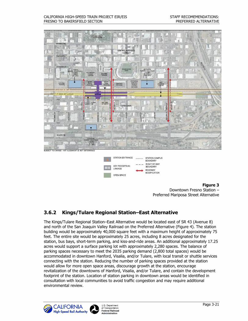
CALIFORNIA HIGH-SPEED TRAIN PROJECT EIR/EIS STAFF RECOMEMENDATIONS:
FRESNO TO BAKERSFIELD SECTION PREFERRED ALTERNATIVE
Page 3-21
Figure 3
Downtown Fresno Station – Preferred Mariposa Street Alternative
3.6.2 Kings/Tulare Regional Station–East Alternative
The Kings/Tulare Regional Station–East Alternative would be located east of SR 43 (Avenue 8) and north of the San Joaquin Valley Railroad on the Preferred Alternative (Figure 4). The station
building would be approximately 40,000 square feet with a maximum height of approximately 75 feet. The entire site would be approximately 25 acres, including 8 acres designated for the
station, bus bays, short-term parking, and kiss-and-ride areas. An additional approximately 17.25
acres would support a surface parking lot with approximately 2,280 spaces. The balance of parking spaces necessary to meet the 2035 parking demand (2,800 total spaces) would be
accommodated in downtown Hanford, Visalia, and/or Tulare, with local transit or shuttle services connecting with the station. Reducing the number of parking spaces provided at the station
would allow for more open space areas, discourage growth at the station, encourage revitalization of the downtowns of Hanford, Visalia, and/or Tulare, and contain the development
footprint of the station. Location of station parking in downtown areas would be identified in
consultation with local communities to avoid traffic congestion and may require additional environmental review.
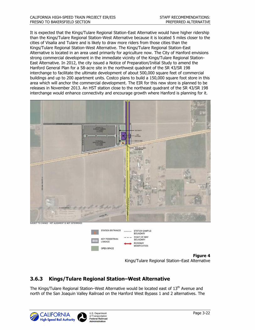
CALIFORNIA HIGH-SPEED TRAIN PROJECT EIR/EIS STAFF RECOMEMENDATIONS:
FRESNO TO BAKERSFIELD SECTION PREFERRED ALTERNATIVE
Page 3-22
It is expected that the Kings/Tulare Regional Station-East Alternative would have higher ridership
than the Kings/Tulare Regional Station-West Alternative because it is located 5 miles closer to the cities of Visalia and Tulare and is likely to draw more riders from those cities than the
Kings/Tulare Regional Station-West Alternative. The Kings/Tulare Regional Station-East Alternative is located in an area used primarily for agriculture now. The City of Hanford envisions
strong commercial development in the immediate vicinity of the Kings/Tulare Regional Station-
East Alternative. In 2012, the city issued a Notice of Preparation/Initial Study to amend the Hanford General Plan for a 58-acre site in the northwest quadrant of the SR 43/SR 198
interchange to facilitate the ultimate development of about 500,000 square feet of commercial buildings and up to 200 apartment units. Costco plans to build a 150,000 square foot store in this
area which will anchor the commercial development. The EIR for this new store is planned to be releases in November 2013. An HST station close to the northeast quadrant of the SR 43/SR 198
interchange would enhance connectivity and encourage growth where Hanford is planning for it.
Figure 4 Kings/Tulare Regional Station–East Alternative
3.6.3 Kings/Tulare Regional Station–West Alternative
The Kings/Tulare Regional Station–West Alternative would be located east of 13th Avenue and north of the San Joaquin Valley Railroad on the Hanford West Bypass 1 and 2 alternatives. The
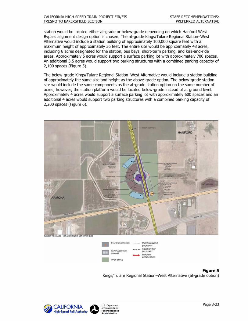
CALIFORNIA HIGH-SPEED TRAIN PROJECT EIR/EIS STAFF RECOMEMENDATIONS:
FRESNO TO BAKERSFIELD SECTION PREFERRED ALTERNATIVE
Page 3-23
station would be located either at-grade or below-grade depending on which Hanford West
Bypass alignment design option is chosen. The at-grade Kings/Tulare Regional Station–West Alternative would include a station building of approximately 100,000 square feet with a
maximum height of approximately 36 feet. The entire site would be approximately 48 acres, including 6 acres designated for the station, bus bays, short-term parking, and kiss-and-ride
areas. Approximately 5 acres would support a surface parking lot with approximately 700 spaces.
An additional 3.5 acres would support two parking structures with a combined parking capacity of 2,100 spaces (Figure 5).
The below-grade Kings/Tulare Regional Station–West Alternative would include a station building
of approximately the same size and height as the above-grade option. The below-grade station site would include the same components as the at-grade station option on the same number of
acres; however, the station platform would be located below-grade instead of at ground level. Approximately 4 acres would support a surface parking lot with approximately 600 spaces and an
additional 4 acres would support two parking structures with a combined parking capacity of
2,200 spaces (Figure 6).
Figure 5 Kings/Tulare Regional Station–West Alternative (at-grade option)
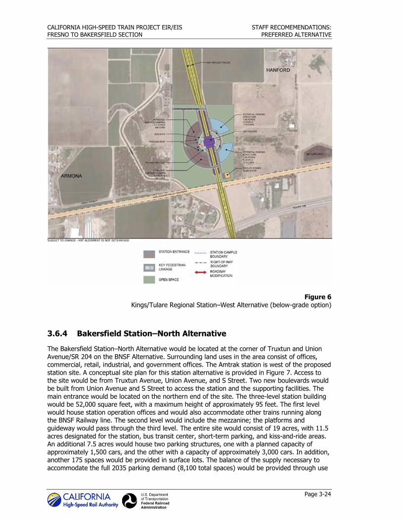
CALIFORNIA HIGH-SPEED TRAIN PROJECT EIR/EIS STAFF RECOMEMENDATIONS:
FRESNO TO BAKERSFIELD SECTION PREFERRED ALTERNATIVE
Page 3-24
Figure 6
Kings/Tulare Regional Station–West Alternative (below-grade option)
3.6.4 Bakersfield Station–North Alternative
The Bakersfield Station–North Alternative would be located at the corner of Truxtun and Union
Avenue/SR 204 on the BNSF Alternative. Surrounding land uses in the area consist of offices, commercial, retail, industrial, and government offices. The Amtrak station is west of the proposed
station site. A conceptual site plan for this station alternative is provided in Figure 7. Access to the site would be from Truxtun Avenue, Union Avenue, and S Street. Two new boulevards would
be built from Union Avenue and S Street to access the station and the supporting facilities. The
main entrance would be located on the northern end of the site. The three-level station building would be 52,000 square feet, with a maximum height of approximately 95 feet. The first level
would house station operation offices and would also accommodate other trains running along the BNSF Railway line. The second level would include the mezzanine; the platforms and
guideway would pass through the third level. The entire site would consist of 19 acres, with 11.5
acres designated for the station, bus transit center, short-term parking, and kiss-and-ride areas. An additional 7.5 acres would house two parking structures, one with a planned capacity of
approximately 1,500 cars, and the other with a capacity of approximately 3,000 cars. In addition, another 175 spaces would be provided in surface lots. The balance of the supply necessary to
accommodate the full 2035 parking demand (8,100 total spaces) would be provided through use
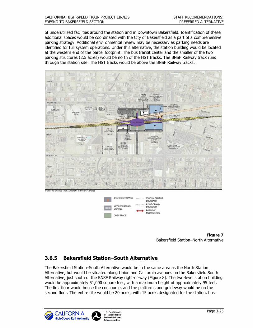
CALIFORNIA HIGH-SPEED TRAIN PROJECT EIR/EIS STAFF RECOMEMENDATIONS:
FRESNO TO BAKERSFIELD SECTION PREFERRED ALTERNATIVE
Page 3-25
of underutilized facilities around the station and in Downtown Bakersfield. Identification of these
additional spaces would be coordinated with the City of Bakersfield as a part of a comprehensive parking strategy. Additional environmental review may be necessary as parking needs are
identified for full system operations. Under this alternative, the station building would be located at the western end of the parcel footprint. The bus transit center and the smaller of the two
parking structures (2.5 acres) would be north of the HST tracks. The BNSF Railway track runs
through the station site. The HST tracks would be above the BNSF Railway tracks.
Figure 7 Bakersfield Station–North Alternative
3.6.5 Bakersfield Station–South Alternative
The Bakersfield Station–South Alternative would be in the same area as the North Station
Alternative, but would be situated along Union and California avenues on the Bakersfield South Alternative, just south of the BNSF Railway right-of-way (Figure 8). The two-level station building
would be approximately 51,000 square feet, with a maximum height of approximately 95 feet.
The first floor would house the concourse, and the platforms and guideway would be on the second floor. The entire site would be 20 acres, with 15 acres designated for the station, bus
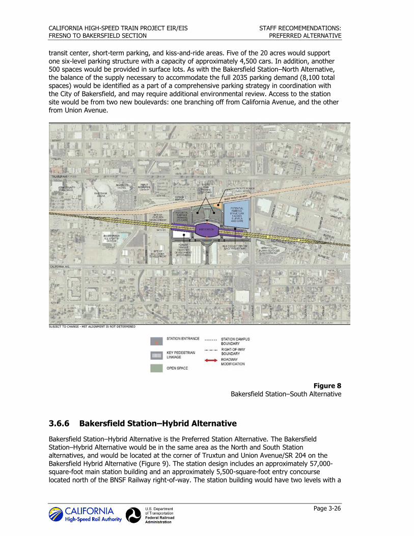
CALIFORNIA HIGH-SPEED TRAIN PROJECT EIR/EIS STAFF RECOMEMENDATIONS:
FRESNO TO BAKERSFIELD SECTION PREFERRED ALTERNATIVE
Page 3-26
transit center, short-term parking, and kiss-and-ride areas. Five of the 20 acres would support
one six-level parking structure with a capacity of approximately 4,500 cars. In addition, another 500 spaces would be provided in surface lots. As with the Bakersfield Station–North Alternative,
the balance of the supply necessary to accommodate the full 2035 parking demand (8,100 total spaces) would be identified as a part of a comprehensive parking strategy in coordination with
the City of Bakersfield, and may require additional environmental review. Access to the station
site would be from two new boulevards: one branching off from California Avenue, and the other from Union Avenue.
Figure 8
Bakersfield Station–South Alternative
3.6.6 Bakersfield Station–Hybrid Alternative
Bakersfield Station–Hybrid Alternative is the Preferred Station Alternative. The Bakersfield
Station–Hybrid Alternative would be in the same area as the North and South Station alternatives, and would be located at the corner of Truxtun and Union Avenue/SR 204 on the
Bakersfield Hybrid Alternative (Figure 9). The station design includes an approximately 57,000-square-foot main station building and an approximately 5,500-square-foot entry concourse
located north of the BNSF Railway right-of-way. The station building would have two levels with a
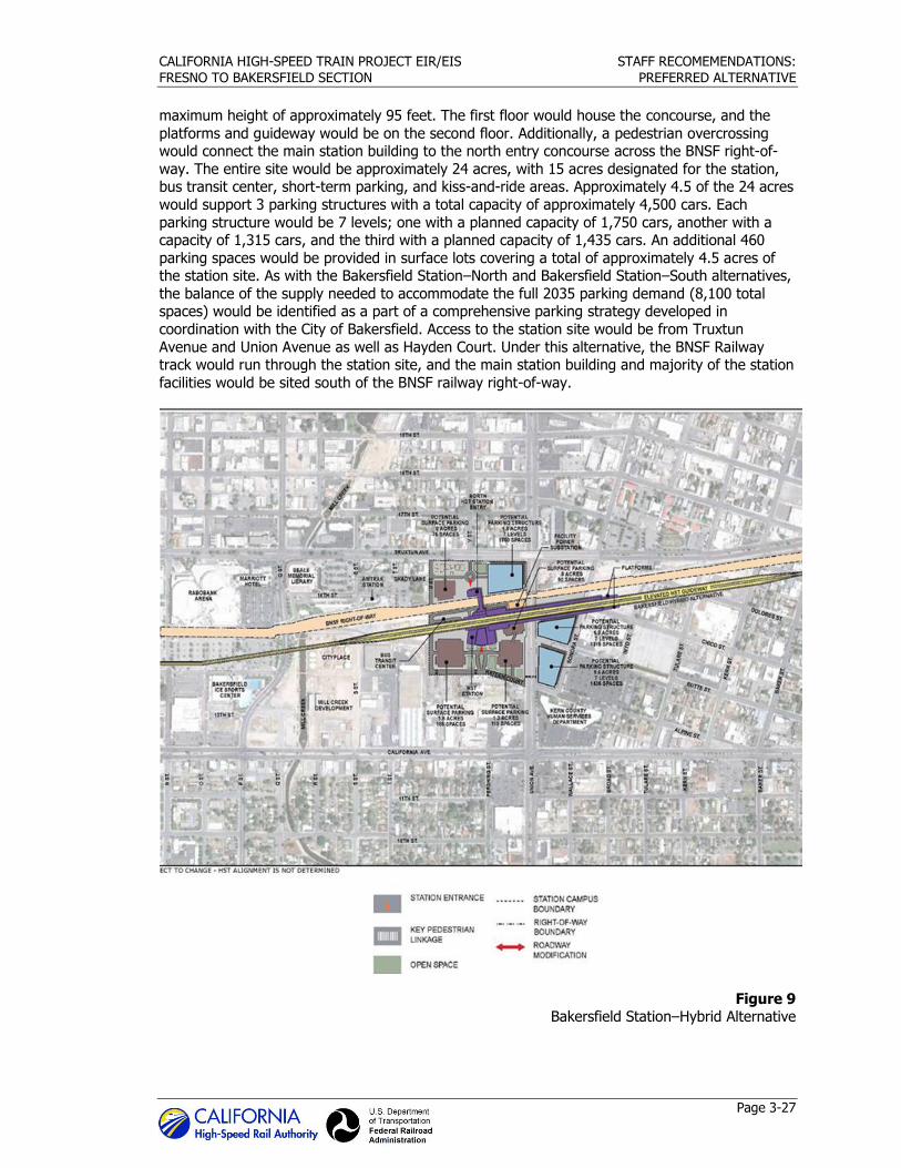
CALIFORNIA HIGH-SPEED TRAIN PROJECT EIR/EIS STAFF RECOMEMENDATIONS:
FRESNO TO BAKERSFIELD SECTION PREFERRED ALTERNATIVE
Page 3-27
maximum height of approximately 95 feet. The first floor would house the concourse, and the
platforms and guideway would be on the second floor. Additionally, a pedestrian overcrossing would connect the main station building to the north entry concourse across the BNSF right-of-
way. The entire site would be approximately 24 acres, with 15 acres designated for the station, bus transit center, short-term parking, and kiss-and-ride areas. Approximately 4.5 of the 24 acres
would support 3 parking structures with a total capacity of approximately 4,500 cars. Each
parking structure would be 7 levels; one with a planned capacity of 1,750 cars, another with a capacity of 1,315 cars, and the third with a planned capacity of 1,435 cars. An additional 460
parking spaces would be provided in surface lots covering a total of approximately 4.5 acres of the station site. As with the Bakersfield Station–North and Bakersfield Station–South alternatives,
the balance of the supply needed to accommodate the full 2035 parking demand (8,100 total spaces) would be identified as a part of a comprehensive parking strategy developed in
coordination with the City of Bakersfield. Access to the station site would be from Truxtun
Avenue and Union Avenue as well as Hayden Court. Under this alternative, the BNSF Railway track would run through the station site, and the main station building and majority of the station
facilities would be sited south of the BNSF railway right-of-way.
Figure 9 Bakersfield Station–Hybrid Alternative
CALIFORNIA HIGH-SPEED TRAIN PROJECT EIR/EIS STAFF RECOMEMENDATIONS:
FRESNO TO BAKERSFIELD SECTION PREFERRED ALTERNATIVE
Page 3-28
3.7 Regulatory Considerations
The Authority and FRA are working closely with federal, state, and regional agencies to meet
regulatory requirements by refining the Fresno to Bakersfield Section alternatives to avoid and minimize impacts and, where necessary, to reach agreement on mitigation measures for impacts
that cannot be avoided. One important process that integrates many of the applicable regulatory requirements is Section 404 CWA and Section 408 as managed by the USACE with oversight from
EPA. The Authority and FRA signed a NEPA/Section 404/408 Integration Process Memorandum of
Understanding (MOU) (Authority et al. 2010), which outlines three major checkpoints in the integration of the NEPA and Section 404/408 process. Each checkpoint consists of the submittal
of technical data and studies by the Authority and FRA to USACE and EPA for review and consideration prior to issuing a formal written agency response. The first of these submittals is
Checkpoint A, which involves preparing a project purpose statement that duly serves NEPA and
Section 404 of the CWA requirements. EPA concurred on the Fresno to Bakersfield Section purpose and need on January 20, 2011, and USACE concurred on the purpose and need on
February 2, 2011, to satisfy Checkpoint A. The second submittal is Checkpoint B, which is required to screen and reduce the potential alternatives to an appropriate range of “reasonable”
and “practicable”2 alternatives using the best available information. On July 5 and June 24, 2011,
respectively, USACE and EPA provided letters on the alternatives that the Authority and FRA proposed to carry through the EIR/EIS. Both agencies concurred on the range of alternatives
except for the Hanford West Bypass Alternative. The Authority and FRA had chosen not to carry the Hanford West Bypass Alternative through the Draft EIR/EIS. The USACE and EPA disagreed
with this decision. The Draft EIR/EIS was circulated without the Hanford West Bypass Alternative.
That alternative was included in the Revised DEIR/Supplemental DEIS.
Finally, Checkpoint C is the assembly and assessment of information contained in the EIR/EIS and associated technical studies for consideration by USACE and EPA in determining the
Preliminary LEDPA and providing a formal agency response. The documentation includes those analyses completed to meet requirements of NEPA, the CWA 401/Section 404, and the Rivers
and Harbor Act Section 14, which include consideration of compliance with the federal Endangered Species Act and the National Historic Preservation Act. The Authority will submit
Checkpoint C materials to the USACE and EPA immediately following the Board decision on the
staff recommended Preferred Alternative. USACE and EPA will independently review staff recommendations and determine the LEDPA for the overall project.
3.8 Agency Consultations
Leading to the submittal of the Checkpoint C information, the FRA, the Authority, and resource
specialists have been meeting with the following agencies: USFWS in development of the Biological Opinion; the California Department of Fish and Wildlife (CDFW) in the development of
a California Endangered Species Act permit and 1602 Streambed Alteration Agreements; the San
Joaquin Central Valley Flood Control Board and the USACE in the development of the approach to the 408 permit related to crossing waters of the U.S.; the State Historic Preservation Office in the
National Historic Preservation Act Section 106 consultation process; the State Water Resources Control Board in development of a Clean Water Act Section 401 Water Quality Certification and
compliance with CWA 402 National Pollution Discharge Elimination System; and the San Joaquin
Valley Air Pollution Control District in the development of construction emission mitigation. Other agencies represented have included EPA and the California Air Resources Board.
2 “Practicability” is defined as available and capable of being done after taking into consideration cost, existing technology, and logistics in light of the overall project purposes (40 CFR Part 230.10(a)(2)).
CALIFORNIA HIGH-SPEED TRAIN PROJECT EIR/EIS STAFF RECOMEMENDATIONS:
FRESNO TO BAKERSFIELD SECTION PREFERRED ALTERNATIVE
Page 3-29
In addition, a series of Technical Working Group (TWG) meetings have occurred to coordinate
and communicate technical issues and clarifications regarding how to assess the functional values of sensitive wetlands and waters of the U.S. so that impacts can be appropriately mitigated. For
mitigation planning, the watershed analysis will provide possible targets for appropriate mitigation. A Compensatory Mitigation Plan is being prepared in coordination with the TWG.
Based on these agency consultations and the information contained above, it is the staff’s
recommendation that the Preferred Alternative is likely to be the LEDPA. The LEDPA recommendation extends only to 7th Standard Road south of the City of Shafter and north of the
City of Bakersfield.

CALIFORNIA HIGH-SPEED TRAIN PROJECT EIR/EIS STAFF RECOMEMENDATIONS:
FRESNO TO BAKERSFIELD SECTION PREFERRED ALTERNATIVE
Page 3-30
This page intentionally left blank
Section 4 Preferred Alternative

CALIFORNIA HIGH-SPEED TRAIN PROJECT EIR/EIS STAFF RECOMEMENDATIONS:
FRESNO TO BAKERSFIELD SECTION PREFERRED ALTERNATIVE
Page 4-1
4.0 Preferred Alternative
The Authority staff is recommending a Preferred Alternative for the Fresno to Bakersfield section
that combines the BNSF Alternative with the Corcoran Bypass, Allensworth Bypass, and Bakersfield Hybrid. The recommended Preferred Alternative includes the Mariposa Street
Alternative for the Downtown Fresno Station (already approved), the Kings/Tulare Regional Station-East Alternative, and the Bakersfield Hybrid Station for the Downtown Bakersfield Station.
This Preferred Alternative was selected based on a balanced consideration of the environmental
information presented in the Draft EIR/EIS and Revised DEIR/Supplemental DEIS in the context of CEQA, NEPA, and Section 404(b)(1) requirements, local and regional land use plans,
community preferences, and cost. Due to influencing factors from adjacent sections, the identification of the preferred HMF location will be done in a future environmental review. The
Authority staff has consulted with FRA staff on the analysis and reasons for selecting the
Preferred Alternative. The recommended Preferred Alternative is shown in Figure 10 and the reasons for the selection of each project feature are described below.
4.1 Preferred Alignment
The selection of the preferred alignment in the Hanford, Corcoran, Allensworth, Wasco-Shafter,
and Bakersfield areas is largely independent of each other. For example, the selection of the preferred alignment in the Hanford area does not influence the selection of the preferred
alignment in the Allensworth area. The one exception to this is the connection of the Hanford
alternatives to the Corcoran alternatives. In this case, the Hanford West Bypass 2 alternatives connect to the Corcoran Bypass and the Through Corcoran Elevated alternatives and the Hanford
West Bypass 1 alternatives connect to the BNSF Alternative through Corcoran. It was necessary to have two slightly different Hanford West Bypass alignments to connect to all of the Corcoran
alternatives because of the geometric constraints of an HST alignment. This exception requires
consideration of both the Hanford and Corcoran alternatives together when evaluating impacts to waters of the U.S. Identification of the preferred alignment in all other area can be done
independently.
In the Hanford area, the BNSF Alternative around the east side of the city was selected for the Preferred Alternative because it is the only alternative that would result in no impacts on
weltands, has the fewest impacts to natural upland habitats, and is more compatible with Hanford’s future growth plans than the Hanford West Bypass alternatives. In the Corcoran area,
the Corcoran Bypass was selected for the Preferred Alternative because it impacts the fewest
acres of wetlands and other waters of the U.S. The Preferred Alternative through the Hanford and Corcoran areas has the fewest impacts to waters of the U.S. of any combination of alignment
alternatives in these two geographic areas. In the Allensworth area, the Allensworth Bypass was selected for the Preferred Alternative because it impacts the fewest acres of wetlands, other
waters of the U.S., natural habitat, and farmlands, and unlike the BNSF Alternative through Allensworth, it does not impact the Allensworth State Historic Park and the Allensworth Ecological
Reserve, both of which are Section 4(f) properties, and it does not displace residential units. In
the Wasco-Shafter area, the BSNF Alternative through these communities was selected for the Preferred Alternative because of strong regional interests, consistency with the long-term
development plans in Shafter, and the cost uncertainties associated with constructing the project in an existing and developing oil field outweigh any reasons to deviate from the existing
transportation corridor in the Wasco Shafter region. The Bakersfield Hybrid Alternative was
selected for the Preferred Alternative because it would impact the fewest acres of quality habitat along the Kern River, it would impact the fewest religious facilities, cause the fewest residential
displacements, and it would not impact the Bakersfield High School campus and Bethel Christian School.
CALIFORNIA HIGH-SPEED TRAIN PROJECT EIR/EIS STAFF RECOMEMENDATIONS:
FRESNO TO BAKERSFIELD SECTION PREFERRED ALTERNATIVE
Page 4-2
The capital cost estimates for all the possible alternatives for the Fresno to Bakersfield section
ranged from about $6.8 billion to $7.6 billion (2010 dollars). The capital cost estimate for the Preferred Alternative is $7.2 billion, approximately in the middle of the range.
The travel time for all the possible alternatives for the Fresno to Bakersfield section ranged from
30 minutes and 29 seconds to 35 minutes and 32 seconds. The Preferred Alternative would take 34 minutes and 5 seconds to travel between Fresno and Bakersfield, and it would add an
additional minute to the Bakersfield to Palmdale Section due to the geometric curves in the Bakersfield Hybrid portion of the alignment. Even at this slower speed in Bakersfield, the
Preferred Alternative would operate well within the optimal express train travel time for the
Fresno to Bakersfield Section.
4.2 Stations
The preferred station for the City of Fresno is the Mariposa Street Station Alternative, already approved. Based on cooperation with the City of Fresno, the Mariposa Street Station Alternative
provides the best opportunity for enhancement of land use densities consistent with the City’s current planning for transit-oriented development in the draft Fulton Corridor Specific Plan and
the draft Downtown Neighborhoods Plan. Stations in the Kings/Tulare area and in Bakersfield
were selected because they lie on the Preferred HST Alternative alignments in those locations. The Kings/Tulare Regional Station will be constructed when ridership warrants.
4.3 Heavy Maintenance Facility
The Authority staff does not recommend making a selection of an HMF site at this time.
CALIFORNIA HIGH-SPEED TRAIN PROJECT EIR/EIS STAFF RECOMEMENDATIONS:
FRESNO TO BAKERSFIELD SECTION PREFERRED ALTERNATIVE
Page 4-3
Figure 10
Fresno to Bakersfield Preferred Alternative
CALIFORNIA HIGH-SPEED TRAIN PROJECT EIR/EIS STAFF RECOMEMENDATIONS:
FRESNO TO BAKERSFIELD SECTION PREFERRED ALTERNATIVE
Page 4-4
CALIFORNIA HIGH-SPEED TRAIN PROJECT EIR/EIS STAFF RECOMEMENDATIONS:
FRESNO TO BAKERSFIELD SECTION PREFERRED ALTERNATIVE
Page 4-5
This page intentionally left blank

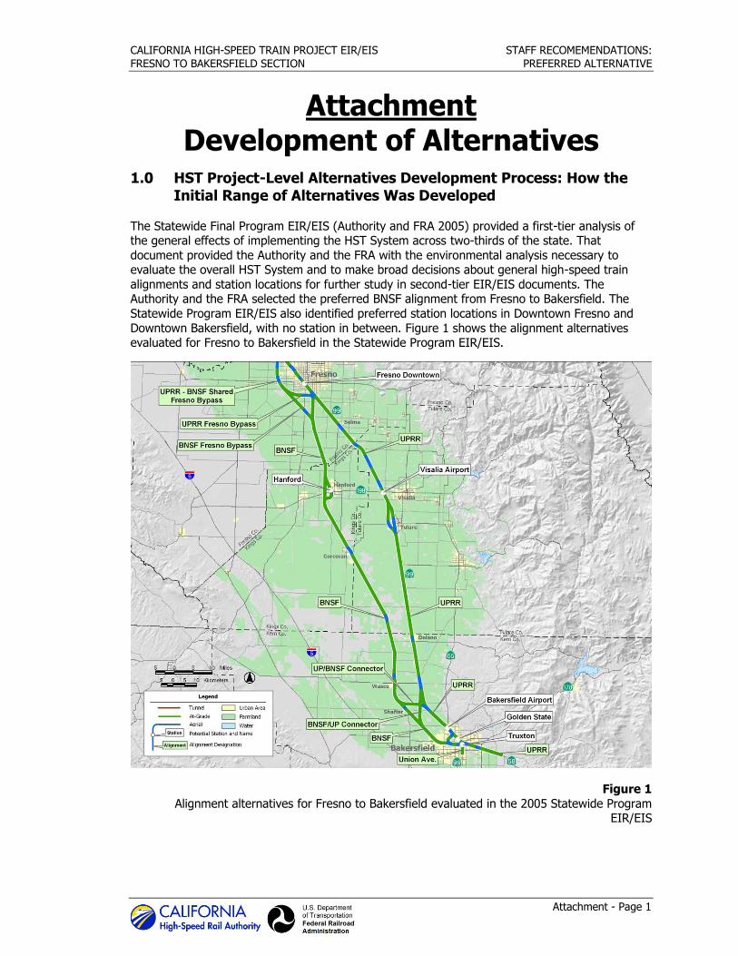
CALIFORNIA HIGH-SPEED TRAIN PROJECT EIR/EIS STAFF RECOMEMENDATIONS:
FRESNO TO BAKERSFIELD SECTION PREFERRED ALTERNATIVE
Attachment - Page 1
Attachment Development of Alternatives
1.0 HST Project-Level Alternatives Development Process: How the Initial Range of Alternatives Was Developed
The Statewide Final Program EIR/EIS (Authority and FRA 2005) provided a first-tier analysis of the general effects of implementing the HST System across two-thirds of the state. That
document provided the Authority and the FRA with the environmental analysis necessary to evaluate the overall HST System and to make broad decisions about general high-speed train
alignments and station locations for further study in second-tier EIR/EIS documents. The Authority and the FRA selected the preferred BNSF alignment from Fresno to Bakersfield. The
Statewide Program EIR/EIS also identified preferred station locations in Downtown Fresno and
Downtown Bakersfield, with no station in between. Figure 1 shows the alignment alternatives evaluated for Fresno to Bakersfield in the Statewide Program EIR/EIS.
Figure 1
Alignment alternatives for Fresno to Bakersfield evaluated in the 2005 Statewide Program EIR/EIS
CALIFORNIA HIGH-SPEED TRAIN PROJECT EIR/EIS STAFF RECOMEMENDATIONS:
FRESNO TO BAKERSFIELD SECTION PREFERRED ALTERNATIVE
Attachment - Page 2
A further assessment of the alternatives, the Visalia-Tulare-Hanford Station Feasibility Study (VTH
Study) (Authority 2007) concluded that a station in the Visalia-Tulare-Hanford area would be feasible. In February 2008, these findings were presented to the Authority Board with a
recommendation that the scope of the project-level environmental review for the Fresno to Bakersfield Section include a potential station in the vicinity of Visalia (Authority 2008).
The conclusions of the Statewide Final Program EIR/EIS and the VTH Study provided the basis
for the initial range of alternatives to be considered in the alternatives analysis process, as described below.
2.0 Development Process for Project-Level Alternatives
After completion of the Statewide Final Program EIR/EIS and the VTH Study, the Authority, in
cooperation with FRA, began the project-specific environmental review process, which included the filing of a Notice of Intent (published in 2009) and an agency and public scoping process.
During the scoping period for the Fresno to Bakersfield Project EIR/EIS, the Authority and FRA received public and agency comments, including comments made during interagency
coordination meetings, to inform the screening evaluation of the initial alternatives.
After the Authority identified the initial project alternatives (based on the Statewide Program EIR/EIS and the VTH Study), alignment plans, preliminary profile concepts, and cross sections
were developed. The project design criteria dictated that the system be designed for 220 mph
throughout with few exceptions (e.g., to avoid sensitive habitat areas, important community resources). These project design criteria provided the basis for the formal alternatives analysis
described below.
2.1 Methodology of the Alternatives Analysis
The evaluation of project-level alternatives followed the process described in Alternatives Analysis Methods for Project EIR/EIS, Version 2 (Authority 2009). The evaluation began with the
Authority’s determination whether each alternative was consistent with the project purpose and need, the basic components of which are as follows:
Capable of reaching operating speeds of 220 mph.
Connects Fresno Station to Bakersfield Station.
Is a practicable alternative.
Other key objectives for the each alternative were:
Provides intercity travel capacity to supplement critically overused interstate highways and
commercial airports.
Meets future intercity travel demand that will be unmet by the present transportation system
and increases capacity for intercity mobility.
Maximizes the use of existing transportation and utility corridors to the extent feasible.
The evaluation process also included measures of potential environmental effects. This assessment involved both qualitative and quantitative measures that addressed applicable policy
and technical considerations. Screening included the use of environmental criteria to measure the potential effects of the proposed alternatives on the natural and human environment. The criteria
included field inspections of corridors to field-verify certain data and a Geographic Information System (GIS)–based analysis of potential impacts to farmland, water resources, wetlands,
CALIFORNIA HIGH-SPEED TRAIN PROJECT EIR/EIS STAFF RECOMEMENDATIONS:
FRESNO TO BAKERSFIELD SECTION PREFERRED ALTERNATIVE
Attachment - Page 3
threatened and endangered species, cultural resources, current urban development, and
infrastructure.
The process also included an evaluation of initial alternatives according to land use and community impact criteria. The land use evaluation measured the extent to which the station
alternatives supported transit use; were consistent with adopted local, regional, and state plans; and were supported by existing and future growth areas. The community impact evaluation
measured the extent of disruption to neighborhoods and communities, such as the potential to minimize (1) right-of-way acquisitions, (2) division of established communities, and (3) conflicts
with community resources.
2.2 Preliminary and Supplemental Alternatives Analyses
To define the project-level alternatives to be considered in the formal environmental process, the Authority and FRA prepared four alternatives analyses (one preliminary report and three
supplemental reports:
Table 1 Alternatives Analysis Reports for the Fresno to Bakersfield Section
Report Date Subject Matter
Preliminary Alternatives Analysis (Authority and FRA 2010a)
June 2010 Comprehensive evaluation of alternatives for the entire Fresno to Bakersfield Section, with focus on three subsections (the Fresno, Rural, and Bakersfield subsections).
Supplemental Alternatives Analysis (Authority and FRA 2010b)
September 2010 Evaluation of potential alignments adjacent to the BNSF tracks through Downtown Hanford.
Supplemental Alternatives Analysis
(Authority and FRA 2011f) May 2011 Additional screening and refinement of alignment
alternatives throughout the section.
Supplemental Alternatives Analysis (Authority and FRA 2011g)
December 2011 Definition and evaluation of potential alignments and station locations west of Hanford.
Although the alternatives analysis process considered multiple criteria, the process emphasized the project objective to maximize the use of existing transportation and utility corridors and
available rights-of-way to the extent feasible.
Preliminary Alternatives Analysis (June 2010)
The alternatives included in the Preliminary AA Report followed the existing freight corridors of the BNSF corridor and the UPRR, the SR 43 corridor, and an electrical transmission corridor east
of Hanford.
The Fresno to Bakersfield Section includes the urbanized areas of Fresno and Bakersfield and the more rural area between the two cities; these areas have varying and different concerns.
Therefore, the Preliminary AA Report divided the corridor into three subsections: Fresno, Rural, and Bakersfield. Linking alternatives from each subsection together formed the complete, end-to-
end alternatives for the Fresno to Bakersfield Section.
The Preliminary AA Report identified five basic initial alternative alignments for the Fresno
Subsection that were based on either the preferred alignment in the Statewide Program EIR/EIS or input from the Fresno Technical Working Group: UPRR East, UPRR West, Golden State
CALIFORNIA HIGH-SPEED TRAIN PROJECT EIR/EIS STAFF RECOMEMENDATIONS:
FRESNO TO BAKERSFIELD SECTION PREFERRED ALTERNATIVE
Attachment - Page 4
Boulevard, SR 99, and Fresno West Bypass. Working from these five basic alternatives, the
Preliminary AA Report defined 13 discrete alignment alternatives that reflected variations in the profile of the HST guideway and in the connections to the Rural Subsection to the south. The
Preliminary AA Report recommended that three alternatives be carried forward for consideration in the EIR/EIS:
UPRR East.
UPRR West.
UPRR West/East Crossover.
All three of these alternatives were assumed to be elevated through Fresno, to be adjacent to the UPRR right-of-way in Fresno, to leave Fresno to the south, generally along the BNSF corridor,
and to provide a Downtown Fresno Station near Mariposa Street (Figure 2).
The Preliminary AA Report identified a set of initial alternatives for the Rural Subsection that originated from a combination of the Statewide Program EIR/EIS; the VTH Study; and input from
local, state, and federal agency officials and stakeholders during the scoping process. The initial alternatives represented variations on alignments following the BNSF and UPRR / SR 99 corridors
from Fresno to Bakersfield. The Preliminary AA Report screening of the initial alternatives
identified six alternatives through the entire length of the Rural Subsection. Three of these alternatives were based on the preferred alignment of the Statewide Program EIR/EIS; these
alternatives generally paralleled the BNSF right-of-way from Fresno to Bakersfield and served a potential station just east of Hanford. The other three alternatives were configured to serve a
potential station closer to Visalia and generally paralleled the UPRR between Fresno and Visalia
before rejoining the BNSF right-of-way south of Corcoran. In addition to these six alternatives for the Rural Subsection, the Preliminary AA Report evaluated a series of “local options” related to
the six alternatives. The local options included different approaches to passing through five areas: (1) Fowler, Selma, and Kingsburg; (2) Hanford; (3) Corcoran; (4) Allensworth; and (5)
Wasco and Shafter. In most cases, these options represented choices to either pass through or around these areas, with additional options in some locations concerning the profile of the HST
guideway (either at-grade or elevated). The Preliminary AA Report recommended that the
following be carried forward into the EIR/EIS (Figure 2):
BNSF Hanford East Bypass
Elevated through Corcoran.
Corcoran At-Grade Bypass.
Allensworth Avoidance.
Elevated through Wasco and Shafter.
Wasco and Shafter At-Grade Bypass.
The initial alternatives for the Bakersfield Subsection described in the Preliminary AA Report were all variations on the preferred alignment in the Statewide Program EIR/EIS and were developed
to reduce potential effects on surrounding land uses, to address community concerns in
Bakersfield, and to locate an HST station in Downtown Bakersfield, near the existing Amtrak Station. The Preliminary AA Report recommended that the following be carried forward into the
EIR/EIS (Figure 2):
Alternative D1; two local options, one with an elevated alignment north of UPRR (D1-N) and
one with an elevated alignment south of UPRR (D1-S).
Alternative D2; two local options, one with an elevated alignment north of the BNSF right-of-
way in central Bakersfield (D2-N) and one with an elevated alignment over the BNSF right-of-way in central Bakersfield (D2-S).
Four Heavy Maintenance Facility sites were recommended for further analysis:
CALIFORNIA HIGH-SPEED TRAIN PROJECT EIR/EIS STAFF RECOMEMENDATIONS:
FRESNO TO BAKERSFIELD SECTION PREFERRED ALTERNATIVE
Attachment - Page 5
The Fresno Works–Fresno HMF Site.
The Kings County–Hanford HMF Site.
The Kern Council of Governments–Wasco HMF Site.
The Kern Council of Governments–Shafter East HMF Site.
A fifth site, Kern Council of Governments—Shafter West, was added for consideration after
completion of the Preliminary AA Report. The HMF site alternatives will be separately considered in the context of the overall system requirements.
On June 3, 2010, the Authority Board met to consider the recommendations of the Preliminary
AA Report (Authority 2010a). The Board acted to accept the recommendations, which are
summarized below (from north-south, according to subsection):
Fresno UPRR West Elevated
Fresno UPRR East Elevated
Fresno UPRR Cross
Rural Full
BNSF–Hanford East
Rural Local Options
Through Corcoran, East Side of BNSF, Elevated
Corcoran East Bypass, At-Grade
Allensworth Bypass Alternative, At-Grade (west of BNSF right-of-way)
Through Wasco and Shafter, Elevated
Wasco and Shafter Bypass, At-Grade
Bakersfield North
Bakersfield South (in California Ave)
HMF site alternatives
Fresno Works–Fresno
Kings County–Hanford
Kern Council of Governments–Wasco
Kern Council of Governments–Shafter
This action provided the basis to move forward with development of the project definition to be
evaluated in the Draft EIR/EIS.
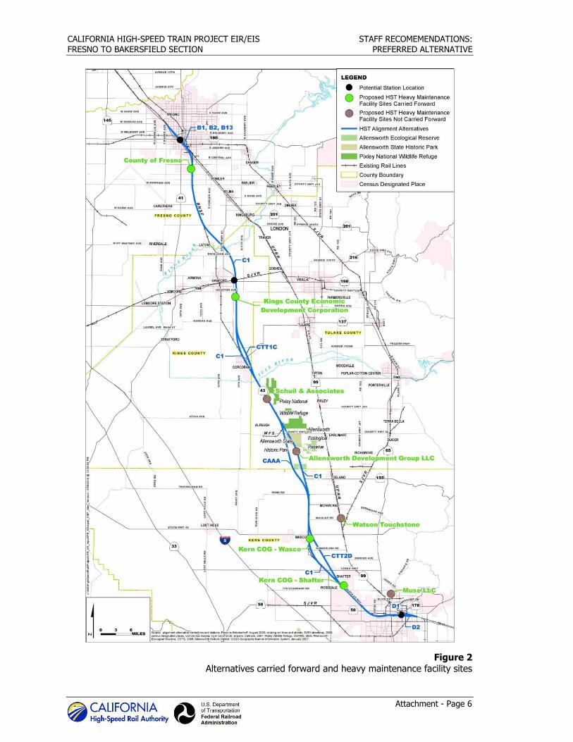
CALIFORNIA HIGH-SPEED TRAIN PROJECT EIR/EIS STAFF RECOMEMENDATIONS:
FRESNO TO BAKERSFIELD SECTION PREFERRED ALTERNATIVE
Attachment - Page 6
Figure 2 Alternatives carried forward and heavy maintenance facility sites
CALIFORNIA HIGH-SPEED TRAIN PROJECT EIR/EIS STAFF RECOMEMENDATIONS:
FRESNO TO BAKERSFIELD SECTION PREFERRED ALTERNATIVE
Attachment - Page 7
Supplemental Alternatives Analysis (September 2010)
In September 2010, in response to concerns about the potential impacts to agricultural lands and
the operation of the BNSF Hanford East Alternative, the Authority issued a Supplemental Alternatives Analysis (Authority and FRA 2010b) to update the Preliminary AA Report (Authority
and FRA 2010a). This analysis identified two alignment options (H1 and H2) that would essentially follow the BNSF right-of-way through Hanford. The two options differed principally in
terms of the location of a potential station, H1 accommodating a station in Downtown Hanford and H2 accommodating a station located approximately halfway between Hanford-Armona Road
and Houston Avenue, at the southern edge of Hanford. The September 2010 Supplemental
Alternatives Analysis recommended that neither of these alternatives be carried forward into the Draft EIR/EIS for the following reasons (relative to the BNSF–Hanford East Alternative):
Increased residential and business impacts.
Increased noise impacts.
No reduction in environmental impacts.
Reduced connectivity for a potential regional station.
No community support.
On September 2, 2010, the Authority Board considered and accepted the recommendations of the September 2010 Supplemental Alternatives Analysis (Authority 2010b). Thus, no changes
were made to the alternatives being developed for consideration in the Draft EIR/EIS.
Supplemental Alternatives Analysis (May 2011)
In May 2011, the Authority issued a second Supplemental Alternatives Analysis (Authority and FRA 2011f) to update the Preliminary AA Report from June 2010 (Authority and FRA 2010a) and
the September 2010 Supplemental Alternatives Analysis (Authority and FRA 2010b). The May 2011 Supplemental Alternatives Analysis presented documentation and analysis of recommended
modifications to the alternatives contained in the prior reports, including the following:
Additions of new alternatives (alignments, station sites, and HMF sites).
Removal of existing alternatives.
Shifts in the horizontal alignments of alternatives.
Changes in the profiles of existing alternatives from elevated to at-grade.
Each of the modifications recommended in the May 2011 Supplemental Alternatives Analysis was
based on one or more of the following benefits:
Reduced impacts on sensitive natural resources and urban populations.
Increased benefits to local residents, property owners, and business owners.
Reduced project and stakeholder costs.
A project with fewer impacts that is more cost-effective overall.
The May 2011 Supplemental Alternatives Analysis made the following recommendations for the
Fresno Subsection:
Change the UPRR West Alternative profile from elevated to at-grade from San Joaquin Street
to Jensen Avenue. Add an alternative station location at Mariposa Street.
Remove UPRR East and Crossover Alternatives from further consideration.
CALIFORNIA HIGH-SPEED TRAIN PROJECT EIR/EIS STAFF RECOMEMENDATIONS:
FRESNO TO BAKERSFIELD SECTION PREFERRED ALTERNATIVE
Attachment - Page 8
The May 2011 Supplemental Alternatives Analysis made the following recommendations for the
Rural Subsection:
Shift the existing alignment between Conejo and Corcoran in two locations: (1) between Conejo and the proposed Kings/Tulare Regional Station (east of Hanford at SR 198) and (2)
between Idaho Avenue (south of the Kings/Tulare Regional Station) and Niles Avenue just
north of Corcoran. Add a new alternative west of BNSF at-grade, from Nevada Avenue north of Corcoran to
Quebec Avenue (Avenue 144) south of Corcoran.
Shift the Preferred Corcoran Alternative closer to Corcoran.
Shift the Allensworth Bypass Alternative to the west.
Shift the BNSF Alternative in Wasco-Shafter closer to BNSF tracks near Kimberlina Road.
North of Shafter: Change the BNSF Alternative profile from elevated to at-grade.
South of Shafter: Change the BNSF Alternative profile from elevated to at-grade, and shift
the alignment from east to west of the BNSF tracks. Shift the Wasco-Shafter Bypass Alternative slightly to the east.
Add a new Shafter candidate HMF site west of the BNSF tracks.
The May 2011 Supplemental Alternatives Analysis made the following recommendations for the Bakersfield Subsection:
Change the profile from elevated to at-grade between Hageman Road and Palm Avenue.
The May 2011 Supplemental Alternatives Analysis also recommended that the alignment definitions for all alternatives be changed from “share BNSF right-of-way” to “remain adjacent to
the BNSF right-of-way.”
On May 5, 2011, the Authority Board considered and accepted the recommendations of the May 2011 Supplemental Alternatives Analysis (Authority 2011a). With these recommendations, in
conjunction with the recommendations of the Preliminary AA Report, the project description and the alternatives to be considered in the Draft EIR/EIS were established.
Supplemental Alternatives Analysis (December 2011)
In December 2011, the Authority issued a third Supplemental Alternatives Analysis (Authority and
FRA 2011g). The previous reports served as the basis for the alternatives contained in the Draft EIR/EIS that was published in August 2011. The December 2011 Supplemental Alternatives
Analysis presented documentation and analysis of a recommended new alignment and station
location west of Hanford in Kings County.
In response to stakeholder, agency, and public feedback on the HST alignment that bypasses
Hanford to the east, the Authority re-introduced alternative routes that would bypass Hanford to
the west, along with alternative station locations (north and south of SR 198) to serve the Kings/Tulare region. A variation on the Hanford West Bypass 1 and 2 alternatives was identified
in the 2005 Statewide Program EIR/EIS (Authority and FRA 2005), so inclusion of these alternatives for further study was consistent with previous decisions.
In commencing with the preparation of the December 2011 Supplemental Alternatives Analysis, the following general characteristics of a new Hanford West Bypass Alternative were defined:
Between Conejo and Corcoran, it would remain adjacent to the BNSF tracks to the greatest
extent possible. It would run primarily at-grade, though other profiles in the general area of SR 198 and the
SJVR–Cross-Valley Railroad tracks would be possible.
CALIFORNIA HIGH-SPEED TRAIN PROJECT EIR/EIS STAFF RECOMEMENDATIONS:
FRESNO TO BAKERSFIELD SECTION PREFERRED ALTERNATIVE
Attachment - Page 9
It would have two variations at the south end to join with either the Corcoran alignments on
the east side of the BNSF tracks or on the west side of the BNSF tracks.
It would be defined to minimize impacts on dairies, wetlands, other agricultural lands,
housing, and community facilities, while providing a feasible, cost-effective option for the Authority.
The December 2011 Supplemental Alternatives Analysis recommended that the Hanford West
Alternative be carried forward for impact analysis and inclusion in the Revised DEIR / Supplemental DEIS (Authority and FRA 2012f). In doing so, the report specified two
locations where an elevated profile would be necessary: (1) the Kings River crossing and (2) the BNSF crossing between Kent and Kansas Avenues (to match the Corcoran Alternatives east and
west of the BNSF tracks. The HST profile near the SJVR and SR 198 crossings was specified to be
at-grade with the appropriate undercrossings or overcrossings of local roads, SJVR, and SR 198.
The December 2011 Supplemental Alternatives Analysis also recommended that a station alternative be located east of 13th Avenue and north of SVJR. The northern location was
determined to afford the best opportunity for intermodal connections, including regional bus service, Amtrak service (via a shuttle to the Downtown Hanford Station), and potential future
commuter rail service using the SJVR. This location was also determined to provide the best opportunity for transit-oriented development, particularly due to its superior access to Downtown
Hanford and the city’s principal retail and office corridor (Lacey Boulevard).
On December 13, 2011, the Authority Board considered and accepted the recommendations of
the December 2011 Supplemental Alternatives Analysis (Authority 2011b). With these recommendations, the project description and alternatives to be considered in the Revised
DEIR / Supplemental DEIS (Authority and FRA 2012f) were established (Figure 3).
2.3 Refinements of Alternatives
After the December 2011 Supplemental Alternatives Analysis, a series of meetings and outreach
activities led to further refinement of the Bakersfield alternatives. The Authority and FRA, in cooperation with the affected stakeholders, developed a hybrid alternative alignment for the
Bakersfield subsection to address substantive comments received during public and agency
review of the Draft EIR/EIS. This hybrid alternative is a variation of the two Bakersfield subsection alternatives evaluated in the Draft EIR/EIS, with all three alternatives sharing
corresponding termini and an HST station generally in the vicinity of Downtown Bakersfield, near the Amtrak station. The Bakersfield Hybrid Alternative, developed in early 2012, was carried
forward into the environmental analysis in the Revised DEIR / Supplemental DEIS (Authority and
FRA 2012f) (Figure 3).
Subsequent to publication of the Revised DEIR / Supplemental DEIS, minor modifications were made to the Hanford West Bypass alternatives to avoid potential uses of Section 4(f) properties.
In addition, minor modifications were made to account for maintenance access along the alignment and to account for design refinements on the location of communications and power
traction facilities.
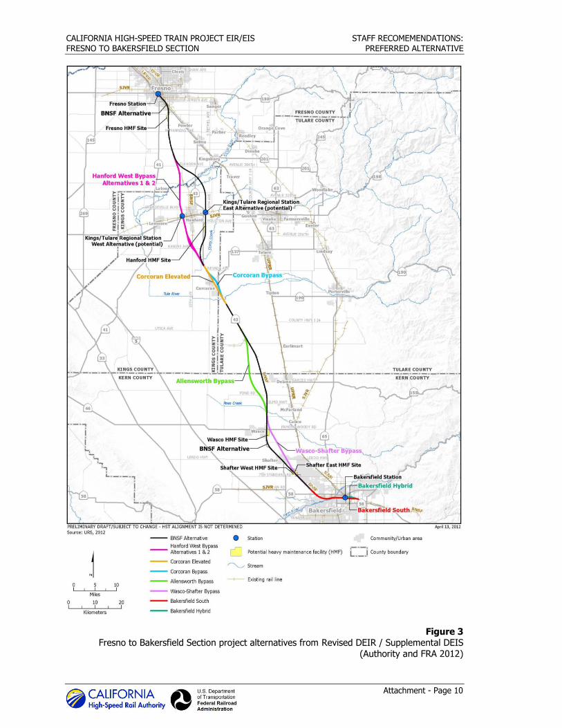
CALIFORNIA HIGH-SPEED TRAIN PROJECT EIR/EIS STAFF RECOMEMENDATIONS:
FRESNO TO BAKERSFIELD SECTION PREFERRED ALTERNATIVE
Attachment - Page 10
Figure 3 Fresno to Bakersfield Section project alternatives from Revised DEIR / Supplemental DEIS
(Authority and FRA 2012)