“cadastral reform in malaysia to support … 2... · “cadastral reform in malaysia to ......
TRANSCRIPT

3rd Land Administration Forum For The Asia And Pacific Region – Re-Engineering The Cadastre To Support
e-Government
Tehran, Iran24-26 May 2009
“CADASTRAL REFORM IN MALAYSIA TO SUPPORT SPATIALLY ENABLED
GOVERNMENT”
Hasan JamilDepartment of Survey and Mapping
Malaysia
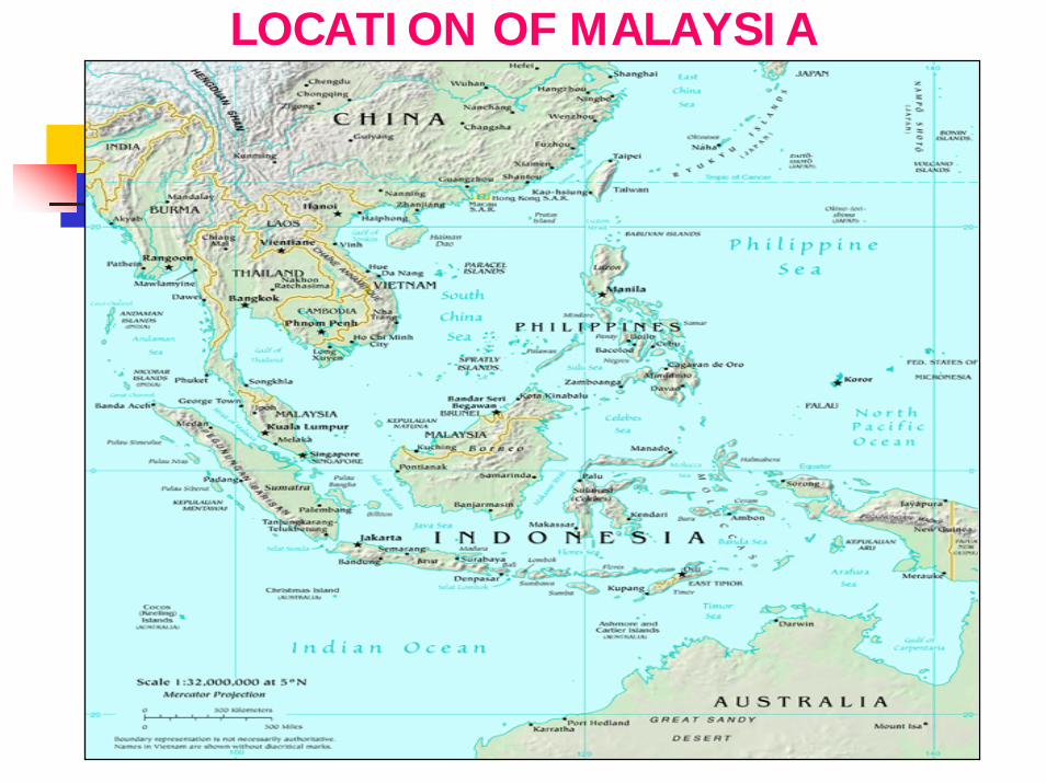
LOCATION OF MALAYSIA

MALAYSIA

MALAYSIA : GEOGRAPHICAL CONTEXT
Covers an area of about 329,758 sq. km.Consists of 11 states in Peninsular Malaysia, 2 states in the island of Borneo (Sabah and Sarawak) and 3 Federal Territories ( Kuala Lumpur, Putrajaya and Labuan)Lies close to the equator between latitudes 1º and 7ºNorth and Longitudes 100º and 119º East. A multi-racial country with a population of approximately 24.9 million.

MALAYSIA: ADMINISTRATIVE SYSTEM
Federal Government
State Government
Local Authorities
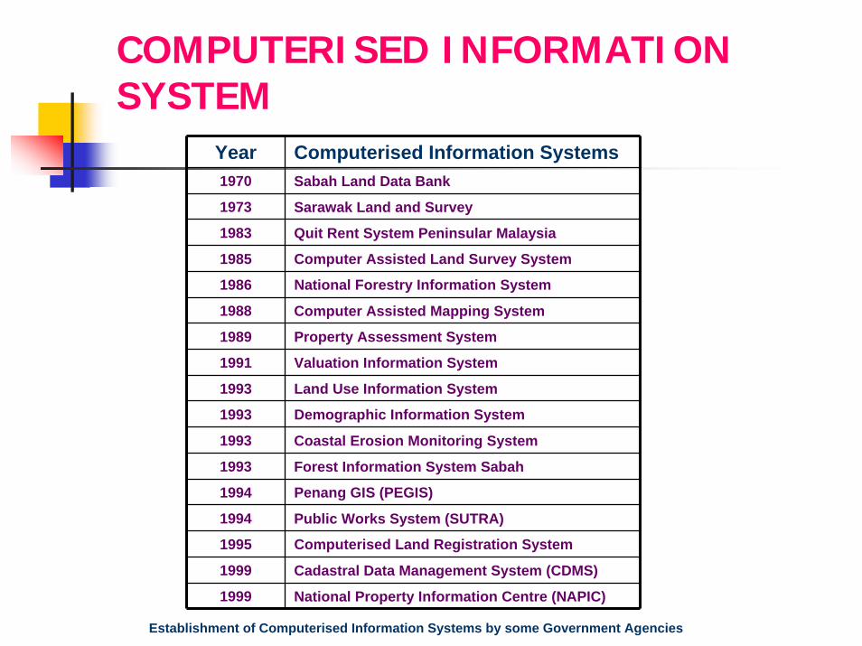
COMPUTERISED INFORMATION SYSTEM
Year Computerised Information Systems1970 Sabah Land Data Bank
1973 Sarawak Land and Survey
1983 Quit Rent System Peninsular Malaysia
1985 Computer Assisted Land Survey System
1986 National Forestry Information System
1988 Computer Assisted Mapping System
1989 Property Assessment System
1991 Valuation Information System
1993 Land Use Information System
1993 Demographic Information System
1993 Coastal Erosion Monitoring System
1993 Forest Information System Sabah
1994 Penang GIS (PEGIS)
1994 Public Works System (SUTRA)
1995 Computerised Land Registration System
1999 Cadastral Data Management System (CDMS)
1999 National Property Information Centre (NAPIC)
Establishment of Computerised Information Systems by some Government Agencies

e-GOVERNMENT
Started since the initiation of Multimedia Super Corridor (MSC) by the Malaysian government in 1996Seeks to improve government operation and delivery services. Introduction of new policies and regulations such as
Communications and Multimedia Act 1998 [Act 588] and [Act 589] Digital Signature Act 1997Computer Crimes Act 1997Copyright Amendment Act 1997Personal Data Protection Act 2004

e-GOVERNMENT PROJECTS
7 pilot projects of the Electronic Government Flagship Application:
Project Monitoring Systems (PMS) – G2G (government to government)Human Resource Management Information System (HRMIS) –G2GGeneric Office Environment (GOE) - G2GElectronic Procurement (EP) – G2B (government to business)Electronic Services (e-Services) – G2C (government to citizen)Electronic Labor Exchange (ELX) – G2CE-Syariah – G2C
MY GOVERNMENT PORTAL
MyGovernment Portal www.gov.my acts as the
one-stop source of Malaysian government information
and services for the citizens.

MALAYSIAN SDI
Formed in 1997, then known as NaLIS (National Infrastructure for Land Information System)
Purpose :
To promote and facilitate sharing, exchange, dissemination and use of geospatial information among Land Related Agencies
To avoid duplication of effort in collection and management of geospatial information
To ensure accuracy, timeliness, correctness and consistency of geospatial information
Restructuring in 2002; subsequently named MyGDI

MyGDI MANAGEMENT STRUCTURE
NATIONAL LAND COUNCIL
MyGDI NATIONAL COORDINATING COMMITTEE
TECHNICAL CLEARINGHOUSE
COMM.
TECHNICAL FRAMEWORK
COMM.
TECHNICAL FRAMEWORK
COMM.
TECHNICAL STANDARD COMM.
MyGDI PLANNING & IMPLEMENTATION COMMITTEE
MaCGDI
STATE COORDINATING COMMITTEE
STATE COORDINATING COMMITTEE
NATIONAL MAPPING &
SPATIAL DATACOMM.
DEPT.OFSTANDARD
SIRIM
TC 2
MyGDI – Malaysian Geospatial Data InfrastructureMaCGDI – Malaysian Centre for Geospatial Data InfrastructureSIRIM - Standards Research Institute of Malaysia

MyGDI FRAMEWORK DATA
12 category of spatial data developed to form the framework data for MyGDI
Geodetic Control
Cadastral
DGLM

STANDARDS
Development of Malaysian Metadata StandardTemplate developed Consistent metadata management tool based on ISO/TC 211 standardCan be used for all data categories Documented and provided to all data providersFree metadata publishing and searching through MyGDI
Development of Malaysian Standard Feature & Attribute Codes (MS1759)
Took into consideration the need to use a standard code for features & their attributes in spatial databases.Documented and published in 2004
Unique Parcel Identifier Standardised Street Addresses
MALAYSIAN CADASTRAL SYSTEM
Historical Outline:
The Torrens system was introduced into the Federated Malay States (FMS) between the years 1879 and 1890.
Finds presence for expression in:The National Land Code, 1965 (NLC) in Peninsular Malaysia.The Sabah Land Ordinance, in the state of Sabah.The Sarawak Land Code, in the state of Sarawak.

MALAYSIAN CADASTRAL SYSTEM (cont.)
Malaysian cadastral system has essentially two basic components:
1. Land Registration: Administered by the State Land Offices and coordinated by Department of Lands and Mines.
Textual aspect - the land register furnishes all necessary information, the basic ones being the name of the proprietor and the actual land alienated - through a description of its area and location, and the survey plan showing the limits. Other information include those on owner's rights, encumbrances, express conditions, caveats and prohibitory orders, if any.

MALAYSIAN CADASTRAL SYSTEM (cont.)
2. Cadastral Survey: Responsibility of Department of Survey and Mapping Malaysia (DSMM), a federal agency and supported by Licensed Land Surveyors(Note: The cadastral survey in the state of Sabah and Sarawak are administered by the respective Department of Lands and Surveys which are state entities.)
Spatial aspect - the country's cadastral parcel fabric can be conveniently viewed from the cadastral map produced and maintained by DSMM. With the exception of land parcels on qualified titles (awaiting surveys and finalisation of boundaries) the map depict all land parcels (i.e. surveyed) together with their unique lot numbers or identifiers, as well as the certified plan numbers for ease of reference and search.

PURPOSE OF CADASTRAL SYSTEM
To provide security and simplicity to all dealings on land.The title is conclusive proof that the person mentioned therein is the owner of the land described therein. Valid titles require an accurate description of boundaries and as such cadastral survey plays an important role in the system.
LAND TITLES
Two type of land titles are issued:
Qualified titles – (Titles issued prior to survey to speed up land development)
Final titles - (Titles issued after accurately surveyed and boundary marks emplaced).
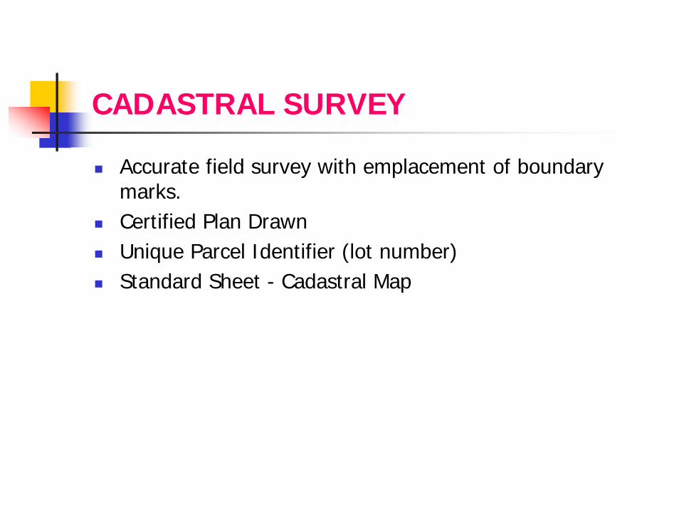
CADASTRAL SURVEY
Accurate field survey with emplacement of boundary marks.Certified Plan DrawnUnique Parcel Identifier (lot number)Standard Sheet - Cadastral Map

Sample of Standard Sheet
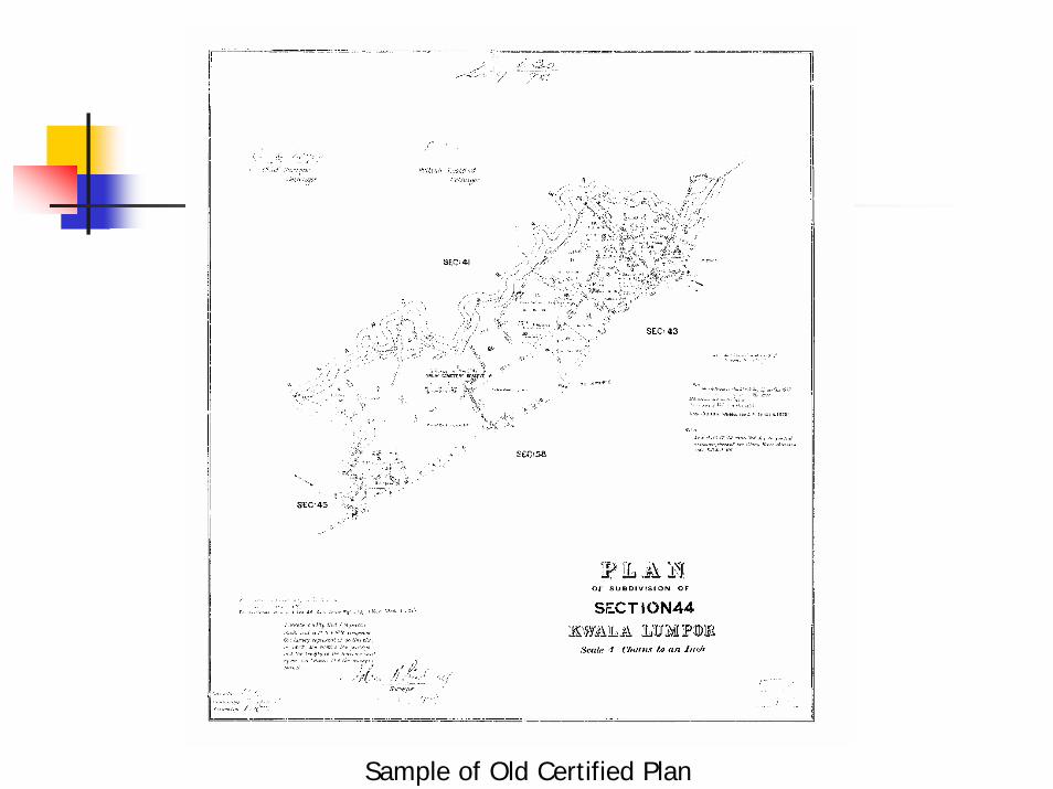
Sample of Old Certified Plan

CADASTRAL REFORMS
o ComputerisationComputer Assisted Land Survey System (CALS)
CALS Johor in 1985CALS Pahang in 1990CALS for other States in 1995
Creation of Digital Cadastral Database (1997-2002)

Sample of Digital Certified Plan

Sample of Digital Cadastral Map

CADASTRAL REFORMS (cont.)
o Feasibility study on Coordinated Cadastral Systems
(CCS) – 1996
o Pilot study in the state of Melaka
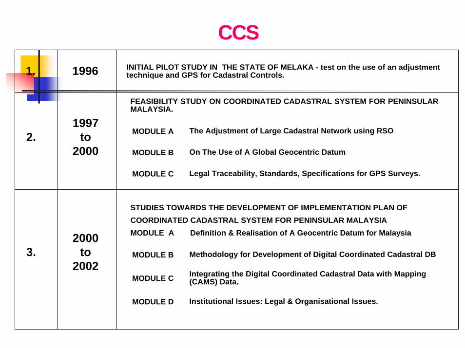
INITIAL PILOT STUDY IN THE STATE OF MELAKA - test on the use of an adjustment 1. 1996 technique and GPS for Cadastral Controls.
FEASIBILITY STUDY ON COORDINATED CADASTRAL SYSTEM FOR PENINSULARMALAYSIA.
1997 MODULE A The Adjustment of Large Cadastral Network using RSO 2. to
2000 MODULE B On The Use of A Global Geocentric Datum
MODULE C Legal Traceability, Standards, Specifications for GPS Surveys.
STUDIES TOWARDS THE DEVELOPMENT OF IMPLEMENTATION PLAN OF COORDINATED CADASTRAL SYSTEM FOR PENINSULAR MALAYSIA MODULE A Definition & Realisation of A Geocentric Datum for Malaysia 2000
3. to MODULE B Methodology for Development of Digital Coordinated Cadastral DB 2002
Integrating the Digital Coordinated Cadastral Data with Mapping MODULE C (CAMS) Data.
MODULE D Institutional Issues: Legal & Organisational Issues.
CCS
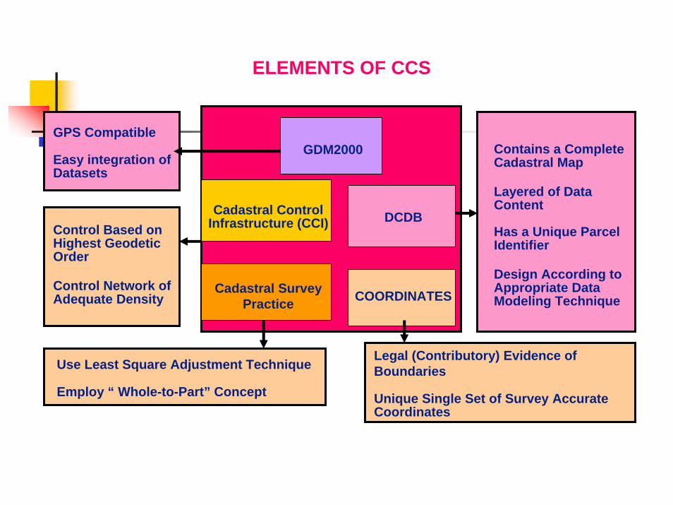
ELEMENTS OF CCS
GPS Compatible Contains a Complete
Easy integration of Cadastral Map Datasets
Layered of Data Content Cadastral Control DCDB Infrastructure (CCI) Control Based on Has a Unique Parcel
Highest Geodetic Identifier Order
Design According to Control Network of Cadastral Survey Appropriate Data COORDINATES Adequate Density Modeling Technique Practice
Legal (Contributory) Evidence of Use Least Square Adjustment Technique Boundaries Employ “ Whole-to-Part” Concept Unique Single Set of Survey Accurate
Coordinates
GDM2000

CADASTRAL REFORMS (cont.)
o Use of Global Navigation Satellite Systems (GNSS)Upgrade geodetic networkMalaysia Active GPS Network (MASS)Use of Geocentric Datum (GDM 2000)Real Time Kinematic Network (RTK Net)Use of GPS in Cadastral Survey

MALAYSIA ACTIVE GPS NETWORK

REAL TIME KINEMATIC NETWORK (RTK Net)

CADASTRAL REFORMS (cont.)
o Field to Finish Concept - 2002Automation of District Office System - District Office Management System
Automation of Field Operation- Total Station System
Automation of Office Operation – upgrading- Cadastral Data Management System- Digital Signature - 2006

Total Station System

District Office Management System
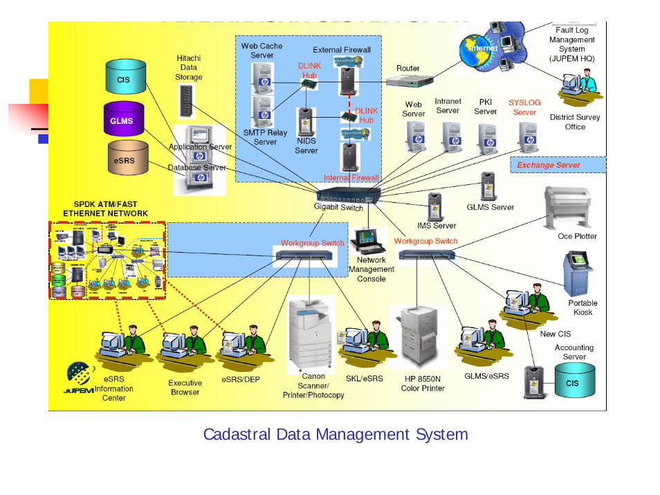
Cadastral Data Management System

CADASTRAL REFORMS (cont.)
o ‘e-cadastre’ Project - 2008
Coordinated Cadastral System (CCS)
Virtual Survey System

‘e-cadastre’ PROJECT
Create Cadastral Control Infrastructure (CCI)Creation of a complete National Digital Cadastral Database (NDCDB).Web base integration between field and office using 3G / Internet.GLMS (GIS Layer Management Systems).Creating database for strata.Using GPS to collecting data (RTK Net).Coordinate system using Cassini GDM 2000

CADASTRAL CONTROL INFRASUCTURECADASTRAL CONTROL INFRASUCTURE
State Number Of CCIState Number Of CCIPerlisPerlis 203203KedahKedah 1,6941,694P PinangP Pinang 934934PerakPerak 3,9413,941Selangor Selangor 4,3244,324WPKLWPKL 1,0711,071N Sembilan 1,608N Sembilan 1,608JohorJohor 4,2214,221PahangPahang 3,1453,145Terengganu 1,810Terengganu 1,810KelantanKelantan 2,0482,048
Total 24,999Total 24,999
500 m for WPKL and 2.5 km for other states

Cadastral Control Infrastructure (CCI)

APPLICATION MODULESe-cadastre
• eLodgement• eKadasOnLine
JUPEM2U
CSRS
eNotification
Web Web GISGIS
• eSIM• eBorang• Ecadasonline• eKiosk• eReporting• eMonitoring
• eNotification
• eTSM
• eCRM
• eSSM
eCRM
eTSM
eSSM
Field Field
Strata• Strata•Strata Data Entry LS
StrataStrataGIS GIS
SUM
eQC
eSPEK
SPEKSPEK
• eSPEK
• eQC
• SUM LSA
Database
• eSupport
• Watchguard • Fortigate
• SPAK• Kalibrasi EDM/GPS
• PKI eSigning• PKI eVerifier• PKI 2D Barcode• eAnotation
•eMedmas
eReporting
eSupport
ePKIeMedmAS
• eReporting
Non GISNon GIS
SPAK
SecuritySPPK• SPPK
ePU DRP
eGLMSDesktop Desktop
GISGIS• ePU
• eJalan• eTownKg• eAdminBdy• eHidrografi• eBangunan• eWarta• eGrid
• ePA, ePA(B)• ePA(S), • ePA(W), eB1• eB4, ePA(M)• ePetakadas
eFEE• eFee
GLMSGLMSPDUSSMPDUSSM
NDCDBNDCDB
eSPID

TITLE SURVEY WORKFLOWLand Office
99
1010 77
11
22
33
44
55
JUPEMJUPEM
Digital PU
Hardcopy PU
Update ePU DB
• SUM Server• LS Adjustment• Initial Check• Accept/Reject
66 •Demarcation Survey•Create JUPEM ASCII•Data validation
CRM Squad creates control points
• QC Server (eQC)• Final validation• Accept/Reject
Update Temp NDCDB
• Update NDCDB• CS digital sign PA• Generate PA and B1
RTK Net
88
Post B1 Tiff to Land Office
LSLS
• Open Survey File• Scan Document• Generate ePU
• Open Survey File• Import PU ASCII• Generate ePU
Update CSRSJUPEM2UJUPEM2U
InternetInternet
KOMMS KOMMS ServerServer

JUPEM2U Web
LS/JUD
5
CS
7
State
SUM SUM ModuleModule
SUM Server
3
- LSA Validation - Reporting
2
LS/JUD Surveyor
6
eSPEKeSPEK JUPEM2U Server
- Temp. NDCDB Layer - Pending for Approval & Updating - Reporting for CS Signing
8
ASCII DB ASCII Repository
- Oracle Update - Archive 4
eQCeQC JUPEM2U Server
- Job Verification - NDCDB Validation - Reporting (DSM/LLSM)
9
NDCDB CSRS Server
- NDCDB Layer
State
Survey Verification if rejected by JUPEM2U
CSRS DB
State- Job Profile
1
JUPEM2U Web
JUPEM2U Web

‘e-cadastre’ PROJECT
Still being tested for full implementation

Application Of Cadastral Data For Acquisition Of Land
Proposed New Road
4536
75374534
4036
75469539
4538 55874783
4507State Land4537
6536
4538
Data required:Location of parcelsSize of parcelsLand valuePosition of roadLand ownersEtc.
Answers to:Where to acquire?Size/area of parcel taken up by road?How much to acquire?Compensation ?Whom to pay?Lot balance to issue new title ?Etc.

CONCLUSION
Cadastral data is one of the framework data neededfor planning and various analysis.
Cadastral reforms carried out are able to create accurate and complete National Cadastral Database and able to expedite the issuance of final title.
Complete National Cadastral Database is much needed to ensure accurate planning and analysis for Spatially Enabled Government.

Thank You