by genda chen, emitt c. witt iii, david hoffman, ronaldo ... · by genda chen, emitt c. witt iii,...
TRANSCRIPT

Analysis of the Interstate 10 Twin Bridge’s Collapse During Hurricane Katrina
By Genda Chen, Emitt C. Witt III, David Hoffman, Ronaldo Luna, and Adam Sevi
The Interstate 10 Twin Span Bridge over Lake Pontchartrain north of New Orleans, La., was rendered completely unusable by Hurricane Katrina. The cause of the collapse of the bridges generated great interest among hydrologists and structural engineers as well as among the general public. What made this case study even more important was the fact that two nearby bridges sustained the effects of the same storm surge and suffered only light damage. Lessons learned from this investigation are invaluable to maintaining the safety of many of the Nation’s coastal and river-crossing bridges.
IntroductionOn October
7, 2005, the U.S. Geological Survey’s (USGS) Mid-Continent Geographic Science Center partnered with the University of Missouri-Rolla (UMR) Natural Hazards Mitigation Institute to send a reconnaissance team to the areas around New Orleans, La., that were damaged by Hurricane
Katrina. Among their activities, the team used a Jon boat
to inspect in detail
the failure of the Interstate 10 (I-10)
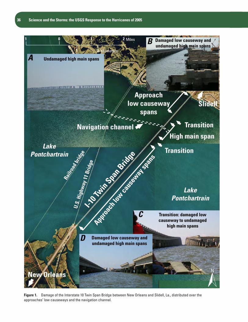
Twin Span Bridge over Lake Pontchartrain. Figure 1 shows
the I-10 twin bridges and the relationship of the approach’s
low causeways on both sides of the navigation channel’s
high main span. It was determined that air trapped beneath the deck of the I-10 bridges was a major contributing factor to the bridges’ collapse. This finding was well supported by evidence observed
in nearby bridges that suffered little or
no damage.A similar issue was
noted by engineers during the 1993 flooding of the
Mississippi River. As river levels were increasing to record
heights in the St. Louis, Mo., area, engineers drilled 57 holes in the deck
of the Gravois Road bridge to prevent it from being floated off its supports by the
rising River des Peres.
36 Science and the Storms: the USGS Response to the Hurricanes of 2005
Undamaged high main spansA
B
D
C Transition: damaged low causeway to undamaged
high main spans
Damaged low causeway and undamaged high main spans
Damaged low causeway and undamaged high main spans
I-10 T
win Spa
n Brid
ge
Appro
ach l
ow ca
usew
ay sp
ans
U.S.
Hig
hway
11
Brid
ge
Railr
oad b
ridge
New Orleans
Transition
High main span
Transition
SlidellApproach
low causewayspans
Navigation channel
LakePontchartrain
LakePontchartrain
2101
1
Miles
Kilometers2
N
Figure 1. Damage of the Interstate 10 Twin Span Bridge between New Orleans and Slidell, La., distributed over the approaches’ low causeways and the navigation channel.

Analysis of the Interstate 10 Twin Bridge’s Collapse During Hurricane Katrina 37
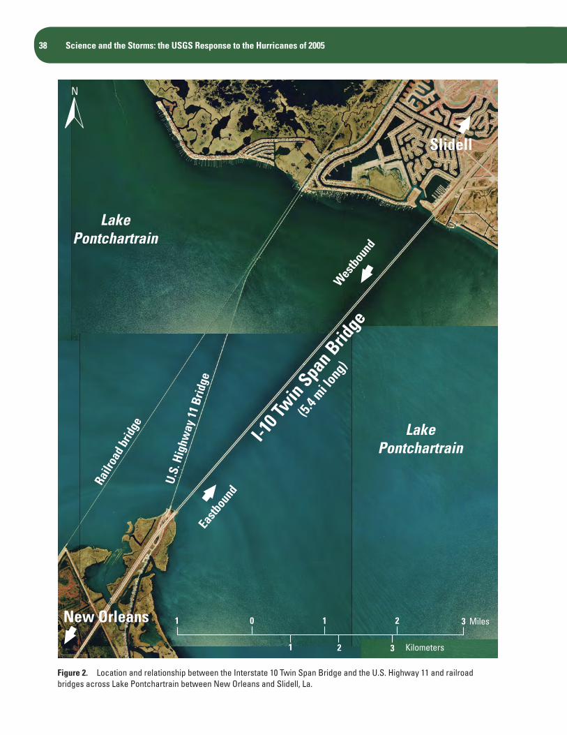
I-10 Twin Span BridgeBuilt in 1963, the I-10 twin bridges are 5.4-mi-long (8.6-
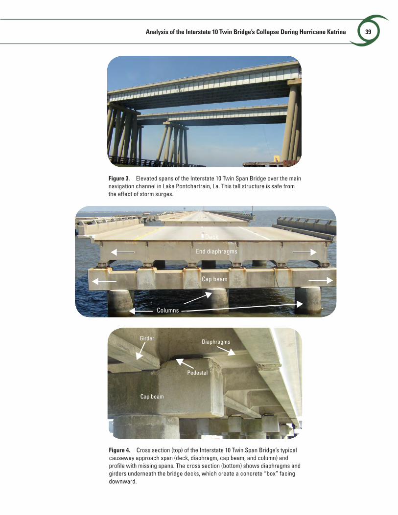
km-long) elevated structures across Lake Pontchartrain (fig. 2), connecting New Orleans and Slidell, La. Each structure consists of one main bridge over the navigation channel (fig. 3) and two approaches that stand approximately 8.5 ft (2.6 m) above mean high water level. Each approach is composed of 436 simply supported precast concrete spans that measure 65 ft by 40 ft (19.8 m by 12.2 m) and weigh 285 tons (259 Mg). As shown in a typical cross section of the bridges (fig. 4), each causeway span is composed of a bridge deck, six longitudinal members (girders), and four transverse members (intermediate and end diaphragms). Every two adjacent girders and two diaphragms form a boxed cell with its open side facing down toward the water. The span is supported through low steel-bearing plates on a cap beam supported by three columns.
Structural DamageThe storm surge generated by Katrina severely damaged
the I-10 bridge structures and rendered them impassable. Each approach causeway suffered significant damage or collapse (figs. 4 and 5), whereas the tall structure over the navigation channel shown in figure 3 withstood the storm. According to the bridge maintenance engineer for the Louisiana Department of Transportation and Development (Landers, 2005), 38 spans from the eastbound bridge and 20 spans from the westbound bridge were dislodged and fell either completely or partially into the water (fig. 5). One span from the westbound bridge collapsed into the water (fig. 6). Many spans from both bridges experienced excessive lateral displacement equal to one girder spacing and stopped at the exterior concrete pedestals shown in figure 4. Several spans were displaced into two girder spacings as shown in figure 7. In this case, the second girder passed over the exterior pedestals without experiencing significant damage.
Hydrostatic Analysis and Plausible Reasons for Bridge Collapse
A simple laboratory hydrostatic analysis was conducted by using a rectangular concrete box with one of its six sides open and facing downward. This analysis was done to illustrate the role played by air trapped beneath a bridge deck, which effectively reduces the gravity load (gravity minus buoyancy) on the deck and, in turn, frictional resistance to the drag force of water, wave action, and wind that can act to move the deck sideways. For this experiment, the rectangular box was placed above water. Air inside the box became
A
B
trapped when the water level rose above the level of the open side of the box.
When the ratio of the volume of trapped air in a hollow box to the volume of a corresponding solid rectangular box reaches a value of 55 percent, the effective gravity load of the box becomes zero, and the concrete box will float on the surface of the water. For the I-10 twin bridges, the average ratio value of each bridge deck segment was estimated to be 70 percent. Thus, we conclude that deck flotation was in effect during Katrina. Under this condition, a small horizontal disturbance caused by drag force, wave action, or wind can relatively easily move the bridge deck laterally.
Therefore, the main reason for the collapse and excessive displacement of bridge spans was the apparent loss of effective gravity load which led to the bridge decks floating on the surface of water at the time of failure. After the air escaped and the space filled with water, the bridge decks landed again on the piers but at different transverse locations or dropped off their supports in the longitudinal (traffic) direction.
Supporting EvidenceThe “rectangular box” theory explained above is strongly
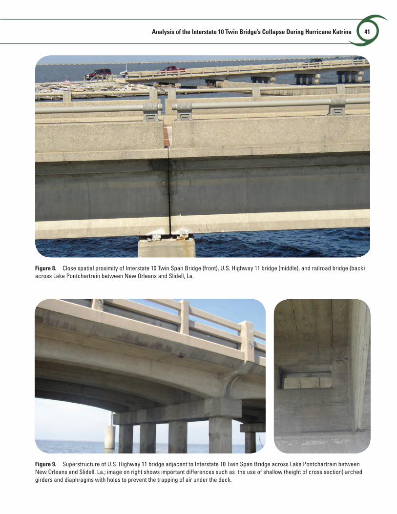
supported by evidence collected from several bridge structures in the areas affected by Katrina. As shown in figures 2 and 8, west of and parallel to the I-10 twin bridges is a highway bridge carrying vehicular traffic on U.S. Highway 11 (US-11). This bridge was open to vehicles after only a short period of traffic interruption. As shown in figure 9, the US-11 bridge is a simply supported concrete girder structure similar to the I-10 bridges. The span lengths are shorter, however, and the depths of all of its girders are significantly shallower than those of the I-10 bridges. In addition, all girders are arch shaped, creating an even shallower section in the middle of every span. The deck sections also had holes in the lateral diaphragms that allowed air to escape the “box.” Therefore, the possibility of having significant air mass trapped beneath the decks of the US-11 bridge is much smaller in comparison with the I-10 bridges.
Still further west is a railway bridge (fig. 2) that did not suffer any structural damage except for a portion of track that washed away. The railroad bridge consists of solid slabs and supporting piers that are illustrated in figure 10. This design makes it difficult to trap air beneath the slabs to reduce their effective gravity loads; consequently, the bridge spans were unlikely to float during the hurricane. Even though a portion of railroad tracks were washed away, there was no evidence that bridge segments had dislocated. The shear keys at both ends of the cap beams may also have helped in this regard.
The velocity of sustained wind and wind gusts during the hurricane and the velocity of the storm-surge current during and after the event were contributing factors, but they were unlikely the root cause of the excessive displacement
38 Science and the Storms: the USGS Response to the Hurricanes of 2005
LakePontchartrain
LakePontchartrain
Railr
oad
brid
ge
I-10 T
win Spa
n Brid
ge
(5.4 m
i long
)
U.S.
Hig
hway
11
Brid
ge
New Orleans
Eastb
ound
Wes
tboun
d
Slidell
N
2101
1 2
Miles
Kilometers
3
3
Figure 2. Location and relationship between the Interstate 10 Twin Span Bridge and the U.S. Highway 11 and railroad bridges across Lake Pontchartrain between New Orleans and Slidell, La.
Analysis of the Interstate 10 Twin Bridge’s Collapse During Hurricane Katrina 39
Figure 3. Elevated spans of the Interstate 10 Twin Span Bridge over the main navigation channel in Lake Pontchartrain, La. This tall structure is safe from the effect of storm surges.
End diaphragms
Cap beam
Columns
Deck
Figure 4. Cross section (top) of the Interstate 10 Twin Span Bridge’s typical causeway approach span (deck, diaphragm, cap beam, and column) and profile with missing spans. The cross section (bottom) shows diaphragms and girders underneath the bridge decks, which create a concrete “box” facing downward.
Girder
Pedestal
Diaphragms
Cap beam
B

40 Science and the Storms: the USGS Response to the Hurricanes of 2005
Figure 5. Interstate 10 Twin Span Bridge’s causeway approach spans dropped off of bent cap beams. One end of each span is in the water.
Figure 7. Westbound Interstate 10 Twin Span Bridge between New Orleans and Slidell, La., exhibiting excessive lateral displacement of approach’s causeway deck. Decks stopped lateral displacement after a distance of one or two girder spacings.
Figure 6. Westbound bridge of Interstate 10 Twin Span Bridge between New Orleans and Slidell, La., with collapsed and missing bent.
Analysis of the Interstate 10 Twin Bridge’s Collapse During Hurricane Katrina 41
Figure 8. Close spatial proximity of Interstate 10 Twin Span Bridge (front), U.S. Highway 11 bridge (middle), and railroad bridge (back) across Lake Pontchartrain between New Orleans and Slidell, La.
Figure 9. Superstructure of U.S. Highway 11 bridge adjacent to Interstate 10 Twin Span Bridge across Lake Pontchartrain between New Orleans and Slidell, La.; image on right shows important differences such as the use of shallow (height of cross section) arched girders and diaphragms with holes to prevent the trapping of air under the deck.

43 Science and the Storms: The USGS Response to the Hurricanes of 200542 Science and the Storms: the USGS Response to the Hurricanes of 2005
in the superstructures of the I-10 bridges. The main bridge over the navigation channel did not experience any damage even though it was subjected to higher wind forces than were the approaches. In addition, all evidence of excessive displacement implies that the superstructures of the I-10 bridges moved eastward, which is inconsistent with the fact that the strongest winds came from the east. The eye of Katrina, however, passed from south to north about 12–15 mi (19.2–24 km) east of the I-10 bridges. Because of the counterclockwise rotation of the storm, the strongest winds and highest storm surge normally occur to the east and north of the eye. As the storm continued north, the hurricane-force winds changed direction to the south and then to the east. The large expanse of Lake Pontchartrain to the west of the I-10 bridges would be able to generate large waves because of the long fetch exposed to the easterly winds at a time when the storm surge was still high. This ability would cause high water levels with large waves directed to the east.
The role played by the easterly wind, large waves, storm surge, and their interaction with the bridges is still under investigation. If the wave effect was dominant during Katrina, the railway and US-11 bridges would have served as a wave-break system for the I-10 twin bridges. In such a scenario, the effect of the waves on the I-10 bridges would have been reduced, and less damage would have been expected to happen to the twin bridges. Similarly, the extensive lateral displacement of several spans purely by wave action (fig. 7) would likely have caused severe damage either to the concrete columns of the cap beam or at the bottom of the first interior girder as the girder passed horizontally over the column horizontally. Neither instance was supported by field observation.
Figure 10. Overview and deck details of the railway bridge adjacent to Interstate 10 Twin Span Bridge between New Orleans and Slidell, La.; inset photo shows important differences such as the use of a solid deck (no hollow space underneath) and a shear key at ends of each cap beam (to prevent lateral movement).
Shear key
SummaryThe reconnaissance team of the USGS Mid-Continent
Geographic Science Center and the UMR Natural Hazards Mitigation Institute collected detailed damage data for the I-10 twin bridges. Based on a simple laboratory experiment involving a rectangular concrete box and analysis of the resulting data, the root cause of the excessive horizontal displacement of portions of the I-10 twin bridges appears to be air that was trapped beneath the bridge decking, which resulted in the loss of effective gravity load. The actual role played by storm surge, wave action, and wind is still under investigation.
Reference
Landers, J., 2005, Structural engineering—Louisiana, Mississippi rush to repair highways damaged by Hurricane Katrina: Civil Engineering—ASCE, v. 75, no. 11, p. 13–14.