brush-tailed rock wallaby recovery plan - city of ipswich
TRANSCRIPT

Brush-tailed Rock Wallaby Recovery Plan
1893 FloodsIpswich.qld.gov.au
Join us online:

Contents
Introduction ........................................................... 2
Context ................................................................ 2
Habitat and behaviour .......................................... 2
Conservation status .............................................. 2
Direction of the recovery implementation plan ......... 3
Vision ..................................................................... 4
Overall Objective ................................................... 4
Known Threats and Reasons for Decline ................ 5
Fire ..................................................................... 5
Predation ............................................................. 5
Competition ......................................................... 5
Disturbance ......................................................... 6
Genetic diversity and small population size ............. 6
Brush-tailed Rock Wallabies in Ipswich .................. 7
Teviot Range ........................................................ 7
The effect of fire on the brush-tailed rock wallaby: A case study of Flinders-Goolman Conservation Estate – 2013 ...................................................... 7
Brush-tailed rock wallaby foraging habitat assessment – 2016 ............................................... 8
Ipswich City Council Brush-tailed rock wallaby monitoring program – 2013 - present .................... 9
Little Liverpool Range ............................................ 9
Recovery Information ............................................. 9
Study areas ........................................................ 10
Actions .............................................................. 13
Habitat assessment matrix ................................... 13
Study Areas - Overview and Actions .................... 14
RW01 - Flinders Plum Overlook ........................... 15
RW02 - Mount Catherine .................................... 17
RW03 - Mount Blaine ......................................... 19
RW04 - The Den ................................................ 22
RW05 - Mount Goolman .................................... 23
RW06 - Mount Flinders Saddle ............................ 25
RW07 - Rocky Knoll Mount Blaine Track ............... 27
RW08 - The Bommy ........................................... 29
RW09 - Scott’s Scrub Pinnacle ............................. 31
RW10 - Flinders Peak East Ridge .......................... 33
RW11 - Ivory’s Rock ........................................... 35
RW12 - The Gallery ............................................ 37
RW13 - Flinders Foot .......................................... 39
RW14 - The Descent ........................................... 42
RW15 - Roads End ............................................. 43
RW16 - Mt Beau Brummel .................................. 45
RW17 - Flinders Peak North East ......................... 47
RW18 - Mt Beau Brummel .................................. 49
RW19 - White Rock-Spring Mountain Conservation Estate ............................................ 51
Implementation.................................................... 53
Priority actions .................................................... 56
Additional Actions and Considerations ................ 57
Relocation, captive breeding and translocation ..... 57
Community awareness ........................................ 57
Working with adjacent landholders....................... 57
Monitoring schedule ............................................ 58
Study area monitoring ......................................... 58
Links with the NAE pest management program ...... 58
Monitoring and reporting on actions .................... 58
Evaluation ............................................................ 59
1
Introduction
ContextIpswich is home to two separate populations of brush-tailed rock wallaby (Petrogale penicillata) in the Teviot Range and Little Liverpool Range. The species is the faunal emblem and mascot for the City of Ipswich. The brush-tailed rock wallaby is also recognised as one of five iconic species for the Ipswich region in in the 2015 Nature Conservation Strategy, along with the koala, platypus, plunkett mallee and Cooneana olive. The 2,220 hectare Flinders-Goolman Conservation Estate, including 106 hectares of state-owned Protected Area, was purchased primarily for the protection of rock wallaby habitat.
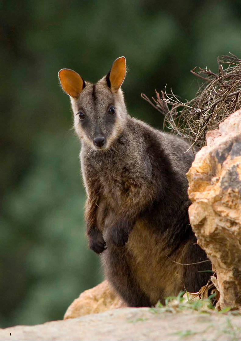
Habitat and behaviourThe brush-tailed rock wallaby is a medium-sized macropod characterised by a dark brushy tail. It is the only rock wallaby endemic to south-east Australia.
Brush-tailed rock wallabies have specialised habitat requirements. Within complex rocky habitats, colonies occur in those that contain caves, crevices, steep gullies and ledges and suitable cliff faces usually having a northerly aspect. There are three major types of preferred habitat:
1. Loose piles of large boulders, also referred to as rocky scree, containing a network of underground holes and passageways;
2. Cliffs with numerous mid-level ledges, caves and overhangs; and
3. Isolated rocky outcrops.
These structures are known as shelter habitat and used as daytime resting areas. Brush-tailed rock wallabies are able to navigate through steep terrain due to the extensive granulation on the soles of their feet.
In addition to a shelter habitat, home ranges also consist of a grassy foraging area. In south-east Queensland, individual foraging ranges average between 2-3 hectares. Individuals typically move to foraging areas at dusk and return before dawn to feed. Their diet mainly consists of short grasses and forbs; however varied food items have been recorded among different populations, indicating that the brush-tailed rock wallaby has an adaptable diet. Refuge and foraging sites are linked by routinely-used commuting routes. The brush-tailed rock wallaby is a shy and reclusive animal, exhibiting highly cautious habitats around people and during weather events or high winds.
Conservation statusPopulations once stretched from the Grampians in western Victoria along the Great Dividing Range to Nanango in south-east Queensland, but its distribution has rapidly contracted and has become highly fragmented. The greatest decline has occurred in the southern extent of the distribution range, particularly in Victoria, where only a tiny population in East Gippsland remains. As a result of substantial declines in range and population, the brush-tailed rock wallaby is listed as a vulnerable species under both the Federal Environment Protection and Biodiversity Conservation Act 1999 and State Nature Conservation Act 1992.
Although there are no accurate population numbers, estimations suggest there to be between 15,000 and 30,000 individuals left in the wild (Department of Environment and Climate Change NSW 2008).
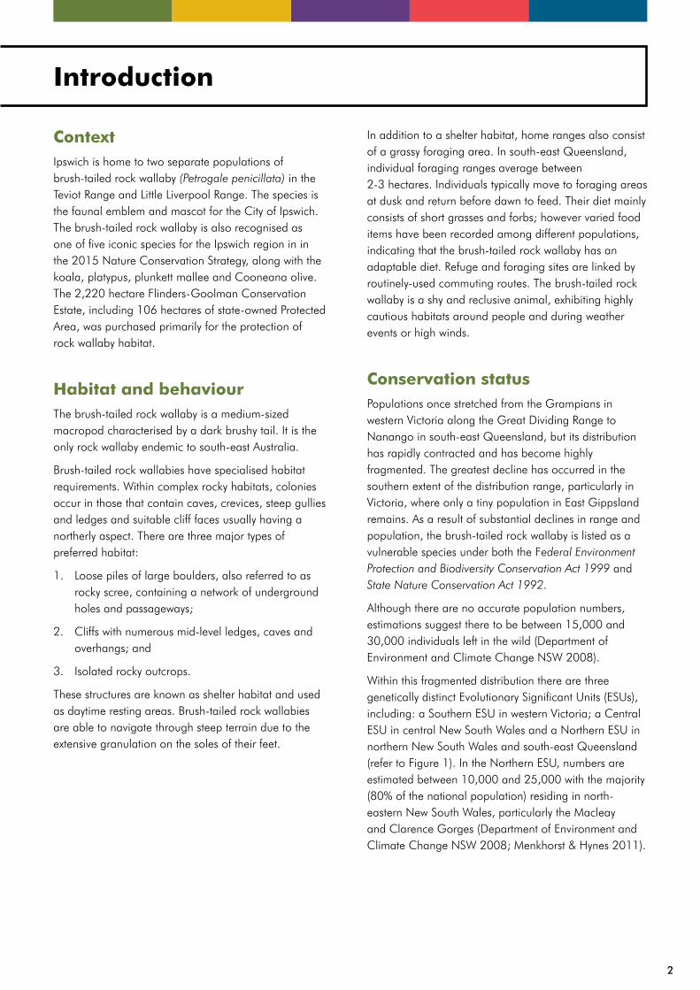
Within this fragmented distribution there are three genetically distinct Evolutionary Significant Units (ESUs), including: a Southern ESU in western Victoria; a Central ESU in central New South Wales and a Northern ESU in northern New South Wales and south-east Queensland (refer to Figure 1). In the Northern ESU, numbers are estimated between 10,000 and 25,000 with the majority (80% of the national population) residing in north-eastern New South Wales, particularly the Macleay and Clarence Gorges (Department of Environment and Climate Change NSW 2008; Menkhorst & Hynes 2011).
2
Figure 1: Approximate boundaries separating the Southern, Central and Northern Evolutionary Significant Units
of brush-tailed rock wallabies (Department of Environment and Climate Change NSW 2008).
Direction of the recovery implementation planThe ‘National recovery plan for the brush-tailed rock wallaby Petrogale penicillata’ was published in 2011 by Menkhorst and Hynes with collaboration from the Federal Government, Queensland, New South Wales and Victorian state governments as well as the ACT Government. It is the first national recovery plan for the species, and details its distribution, habitat, threats and recovery objectives and actions necessary to ensure its long-term survival.
Many of these threats, objectives and actions are relevant to Ipswich in addition to several localised threats not reflected at the national or ESU scale. The purpose of this Recovery Plan is to transpose the national recovery plan to the context of the Ipswich region and provide a framework to facilitate the recovery and stability of brush-tailed rock wallaby populations in Ipswich.
3
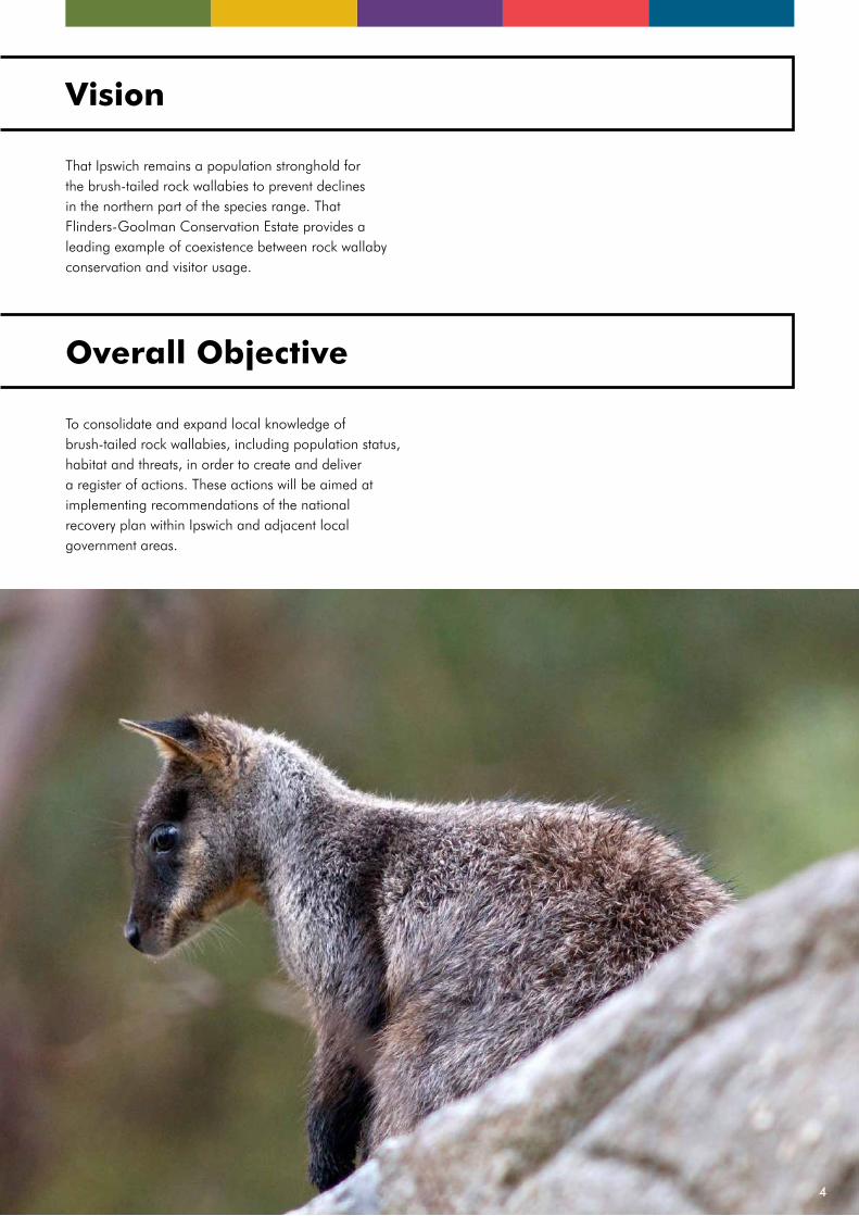
Vision
That Ipswich remains a population stronghold for the brush-tailed rock wallabies to prevent declines in the northern part of the species range. That Flinders-Goolman Conservation Estate provides a leading example of coexistence between rock wallaby conservation and visitor usage.
Overall Objective
To consolidate and expand local knowledge of brush-tailed rock wallabies, including population status, habitat and threats, in order to create and deliver a register of actions. These actions will be aimed at implementing recommendations of the national recovery plan within Ipswich and adjacent local government areas.
4
Known Threats and Reasons for Decline
Rock wallaby shelter habitat is naturally fragmented and often highly isolated. Permanent barriers, such as extreme distance or infrastructure and development between colonies, can lead to reproductive and genetic isolation between colonies only 2-3 km apart. Most colonies now only consist of a small number of individuals, commonly numbering less than 12 wallabies. While sufficient to persist for the long term, colonies of this size are prone to stochastic events, such as disease or wildfire, and are vulnerable to local extinction. In addition to fragmentation and isolation there are a variety of common processes that threaten brush-tailed rock wallabies at an individual, community and landscape level.
FireThe impact of fire on brush-tailed rock wallaby populations has not been comprehensively studied. Although it has been determined that fire has the ability to impact on various rock wallaby species, the effect of large wildfires is relatively unknown. Regular low-intensity burning has been recognized as permitting the growth of suitable forage for wallaby species. In contrast to this, high intensity wildfire significantly impacts on the majority of medium-sized mammal populations, with the ability to both directly kill individuals and cause post-fire starvation through changes to the vegetation and habitat structure.
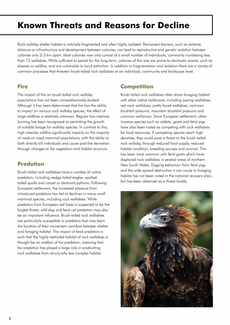
PredationBrush-tailed rock wallabies have a number of native predators, including wedge tailed eagles, spotted tailed quolls and carpet or diamond pythons. Following European settlement, the increased pressure from introduced predators has led to declines in many small mammal species, including rock wallabies. While predation from European red foxes is suspected to be the largest threat, wild dog and feral cat predation may also be an important influence. Brush-tailed rock wallabies are particularly susceptible to predators that may learn the location of their movement corridors between shelter and foraging habitat. The impact of feral predators is such that the highly restricted habitat of rock wallabies is thought be an artefact of fox predation, meaning that fox predation has played a large role in eradicating rock wallabies from structurally less complex habitat.
CompetitionBrush-tailed rock wallabies often share foraging habitat with other native herbivores, including swamp wallabies, red neck wallabies, pretty faced wallabies, common brushtail possums, mountain brushtail possums and common wallaroos. Since European settlement, other invasive species such as rabbits, goats and feral pigs have also been noted as competing with rock wallabies for food resources. If competing species reach high densities, they could pose a threat to the brush-tailed rock wallaby, through reduced food supply, reduced habitat condition, breeding success and survival. This has been most common with feral goats which have displaced rock wallabies in several areas of northern New South Wales. Digging behaviour from feral pigs and the wide spread destruction it can cause to foraging habitat has not been noted in the national recovery plan, but has been observed as a threat locally.
5

DisturbanceMost colonies of brush-tailed rock wallaby are found in rugged and complex terrain often far from human occupation. The increase in popularity of outdoor recreation activities, including rock climbing and mountain hiking, has resulted in an increase in the number of people present in rock wallaby habitat. The impact of direct human disturbance, such as flight disturbance from bushwalkers, on brush-tailed rock wallabies has not been well studied and is difficult to quantify. The brush-tailed rock wallabies reaction to other disturbances may be an indication of its potential behaviour towards humans. For example, rock wallabies are more attentive and hesitant during windy days or rainy nights in order to detect any incoming threats amidst elevated noise levels. A consistent level of human disturbance may therefore hinder or slow rock wallaby feeding behaviours and potentially compromise shelter or foraging habitat.
Genetic diversity and small population sizeThe effect of the increasing isolation of brush-tailed rock wallaby colonies and degraded linking habitat has greatly decreased the species ability to move between colonies. There is very limited spread of genetic material across colonies, resulting in decreased genetic diversity. The loss of genetic variation in a population reduces the ability of the population to respond to environmental change and increases the risk of extinction, through increased inbreeding and genetic drift. This can have negative effects on individual fitness and can lead to an increase in the frequency of expression of unsuitable genes.
Rapid declines in genetic diversity have been recorded in the Southern ESU and Central ESU. Genetic status of the less studied Ipswich’s brush-tailed rock wallaby and Northern ESU is not as clear.
White Rock Outcrop by L OliverIpswich Enviroplan Photo Competition
6
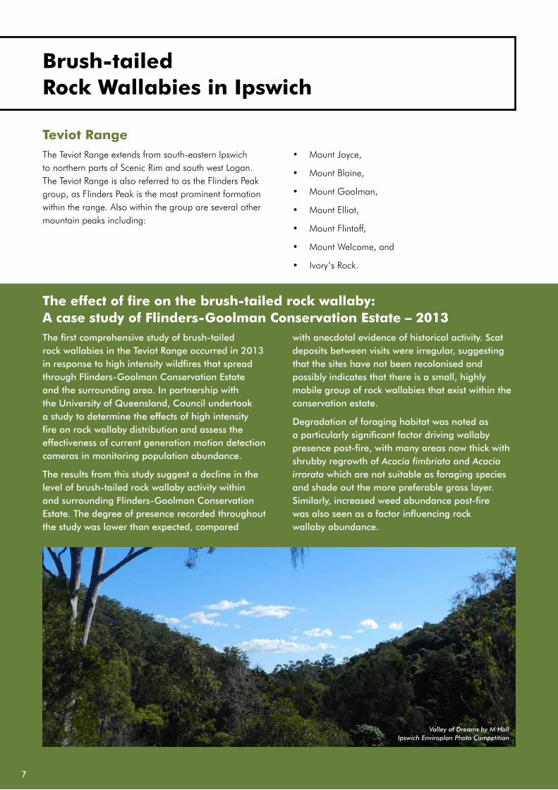
The effect of fire on the brush-tailed rock wallaby: A case study of Flinders-Goolman Conservation Estate – 2013The first comprehensive study of brush-tailed rock wallabies in the Teviot Range occurred in 2013 in response to high intensity wildfires that spread through Flinders-Goolman Conservation Estate and the surrounding area. In partnership with the University of Queensland, Council undertook a study to determine the effects of high intensity fire on rock wallaby distribution and assess the effectiveness of current generation motion detection cameras in monitoring population abundance.
The results from this study suggest a decline in the level of brush-tailed rock wallaby activity within and surrounding Flinders-Goolman Conservation Estate. The degree of presence recorded throughout the study was lower than expected, compared
with anecdotal evidence of historical activity. Scat deposits between visits were irregular, suggesting that the sites have not been recolonised and possibly indicates that there is a small, highly mobile group of rock wallabies that exist within the conservation estate.
Degradation of foraging habitat was noted as a particularly significant factor driving wallaby presence post-fire, with many areas now thick with shrubby regrowth of Acacia fimbriata and Acacia irrorata which are not suitable as foraging species and shade out the more preferable grass layer. Similarly, increased weed abundance post-fire was also seen as a factor influencing rock wallaby abundance.
Teviot RangeThe Teviot Range extends from south-eastern Ipswich to northern parts of Scenic Rim and south west Logan. The Teviot Range is also referred to as the Flinders Peak group, as Flinders Peak is the most prominent formation within the range. Also within the group are several other mountain peaks including:
• Mount Joyce,
• Mount Blaine,
• Mount Goolman,
• Mount Elliot,
• Mount Flintoff,
• Mount Welcome, and
• Ivory’s Rock.
Valley of Dreams by M HallIpswich Enviroplan Photo Competition
7
Brush-tailed Rock Wallabies in Ipswich
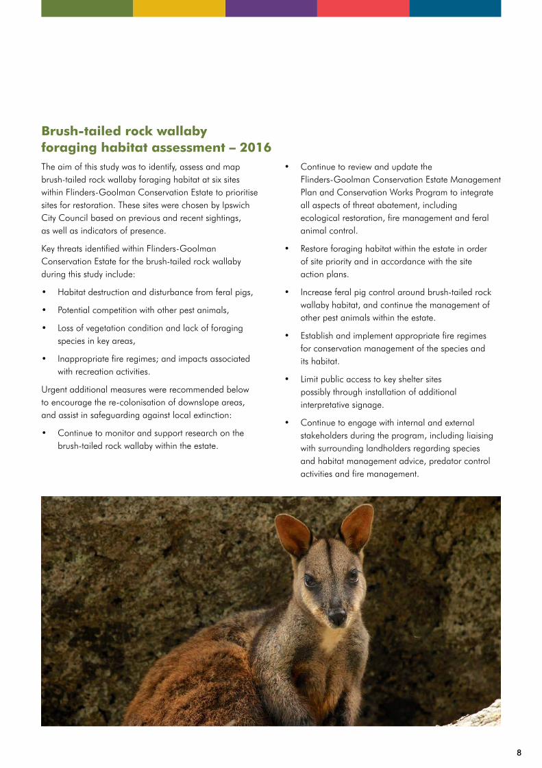
Brush-tailed rock wallaby foraging habitat assessment – 2016The aim of this study was to identify, assess and map brush-tailed rock wallaby foraging habitat at six sites within Flinders-Goolman Conservation Estate to prioritise sites for restoration. These sites were chosen by Ipswich City Council based on previous and recent sightings, as well as indicators of presence.
Key threats identified within Flinders-Goolman Conservation Estate for the brush-tailed rock wallaby during this study include:
• Habitat destruction and disturbance from feral pigs,
• Potential competition with other pest animals,
• Loss of vegetation condition and lack of foraging species in key areas,
• Inappropriate fire regimes; and impacts associated with recreation activities.
Urgent additional measures were recommended below to encourage the re-colonisation of downslope areas, and assist in safeguarding against local extinction:
• Continue to monitor and support research on the brush-tailed rock wallaby within the estate.
• Continue to review and update the Flinders-Goolman Conservation Estate Management Plan and Conservation Works Program to integrate all aspects of threat abatement, including ecological restoration, fire management and feral animal control.
• Restore foraging habitat within the estate in order of site priority and in accordance with the site action plans.
• Increase feral pig control around brush-tailed rock wallaby habitat, and continue the management of other pest animals within the estate.
• Establish and implement appropriate fire regimes for conservation management of the species and its habitat.
• Limit public access to key shelter sites possibly through installation of additional interpretative signage.
• Continue to engage with internal and external stakeholders during the program, including liaising with surrounding landholders regarding species and habitat management advice, predator control activities and fire management.
8
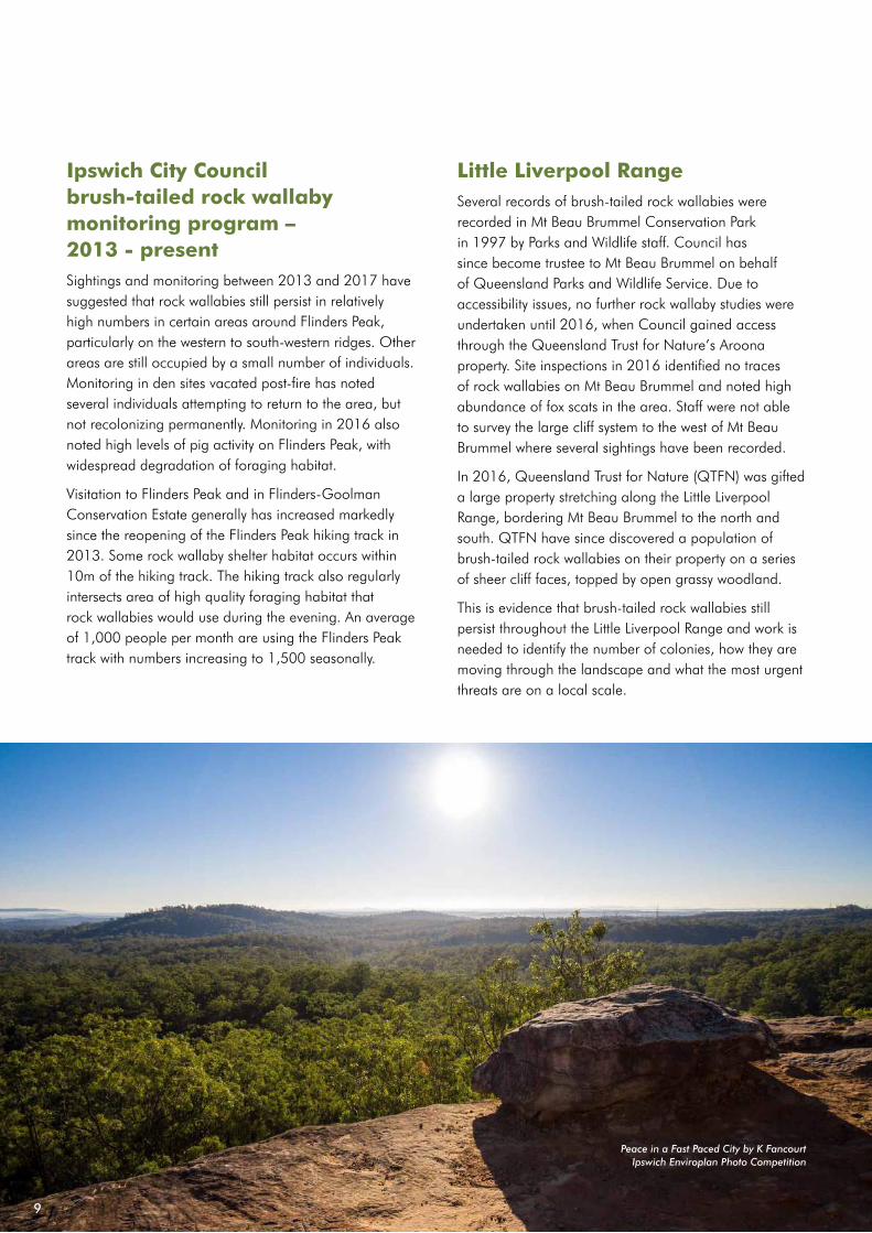
Ipswich City Council brush-tailed rock wallaby monitoring program – 2013 - presentSightings and monitoring between 2013 and 2017 have suggested that rock wallabies still persist in relatively high numbers in certain areas around Flinders Peak, particularly on the western to south-western ridges. Other areas are still occupied by a small number of individuals. Monitoring in den sites vacated post-fire has noted several individuals attempting to return to the area, but not recolonizing permanently. Monitoring in 2016 also noted high levels of pig activity on Flinders Peak, with widespread degradation of foraging habitat.
Visitation to Flinders Peak and in Flinders-Goolman Conservation Estate generally has increased markedly since the reopening of the Flinders Peak hiking track in 2013. Some rock wallaby shelter habitat occurs within 10m of the hiking track. The hiking track also regularly intersects area of high quality foraging habitat that rock wallabies would use during the evening. An average of 1,000 people per month are using the Flinders Peak track with numbers increasing to 1,500 seasonally.
Little Liverpool RangeSeveral records of brush-tailed rock wallabies were recorded in Mt Beau Brummel Conservation Park in 1997 by Parks and Wildlife staff. Council has since become trustee to Mt Beau Brummel on behalf of Queensland Parks and Wildlife Service. Due to accessibility issues, no further rock wallaby studies were undertaken until 2016, when Council gained access through the Queensland Trust for Nature’s Aroona property. Site inspections in 2016 identified no traces of rock wallabies on Mt Beau Brummel and noted high abundance of fox scats in the area. Staff were not able to survey the large cliff system to the west of Mt Beau Brummel where several sightings have been recorded.
In 2016, Queensland Trust for Nature (QTFN) was gifted a large property stretching along the Little Liverpool Range, bordering Mt Beau Brummel to the north and south. QTFN have since discovered a population of brush-tailed rock wallabies on their property on a series of sheer cliff faces, topped by open grassy woodland.
This is evidence that brush-tailed rock wallabies still persist throughout the Little Liverpool Range and work is needed to identify the number of colonies, how they are moving through the landscape and what the most urgent threats are on a local scale.
Peace in a Fast Paced City by K FancourtIpswich Enviroplan Photo Competition
9
Recovery Information
This section will outline specific colonies located within Ipswich, what is known about them and what actions are required to ensure their recovery. Where insufficient information exists, this section addresses what information is required and how it can be attained. For the purpose of prioritisation, most habitat areas are split into study areas, but actions cumulate to meet the overall objectives for the recovery plan.
Study areasGiven that Council is managing a number of separate locations with potentially isolated populations of rock wallabies and spatially variable threats, a number of individual study areas have been developed. Each study area is spatially distinct, typically due to variation in elevation and can therefore be treated with a different priorities based on localised threats.
Study areas are selected based on the following:
• Known records of brush-tailed rock wallabies,
• Anecdotal and trace evidence of rock wallabies,
• Distinct rocky outcrops isolated from other habitat,
• High value rock wallaby habitat that has not been surveyed.
10

11
Figure 2b: Overview map and study areas within Ipswich Local Government Areas.
Locality
Highway
Major road
Watercourse
Detail map extent and figure number
LGA boundary
Estate
LEGEND

12

ActionsEach management area is assigned both objectives and actions based on the issues present within the area. Actions are assigned based on threats noted from various sources, including:
• Evidence from site inspections and monitoring,
• Findings from studies and projects,
• Threats and considerations listed in national recovery plans and strategies.
Habitat assessment matrixA habitat assessment matrix has been developed for use in this recovery plan. The matrix is designed to highlight the overall status of a study area, including consideration of foraging habitat, shelter habitat, and threats from pest animals.
Where possible, each study area will be assessed using the matrix to show which areas have the highest priority. The results from the habitat assessment matrix have been used in combination with all other available data from studies and monitoring programs to assign appropriate actions and priorities to each study area. The matrix can then be used to determine the success of each action by comparing the status of a site pre and post action.
Each visit to a study area should include an assessment of the habitat quality using the matrix and updated in the implementation phase of this plan.
Table 1: Brush-tailed rock wallaby habitat assessment matrix
Criteria Low Moderate High
Quality of shelter habitat
Unsuitable for permanent colony
(temporary shelter only)
Suitable for permanent colony
Highly suitable for permanent colony or
known den site
Quality of foraging vegetation
Very few native foraging species and/or high
weed infestation
Some native foraging species and/or medium to high weed infestation
Abundant native foraging species and/or low to
medium weed infestation
Level of isolationDirectly adjacent to trails
or recreational users
Occasional disturbance from recreational users
and other people
Minimal to no impact from recreational users
or other people
ConnectivityHabitat likely to be isolated from other
colonies or habitat areas
Potential opportunities for movement between
habitat areas
Likely movement corridors and linkages between habitat areas
Predation and competition
High to medium impact from feral predators
and/or high impact from feral herbivores
Low impact from feral predators and/or medium to low competition from
feral herbivores
No evidence of competition or predation
from feral species
13
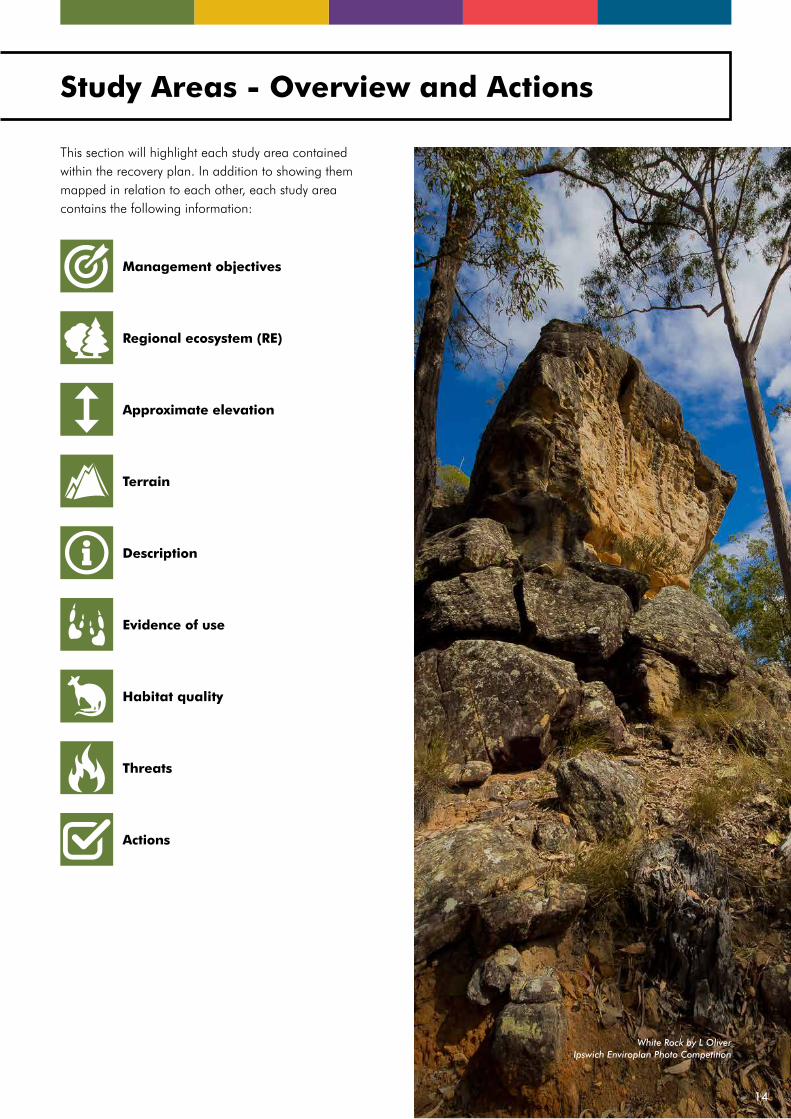
Study Areas - Overview and Actions
This section will highlight each study area contained within the recovery plan. In addition to showing them mapped in relation to each other, each study area contains the following information:
Actions
Management objectives
Regional ecosystem (RE)
Approximate elevation
Terrain
Evidence of use
Habitat quality
Threats
Description
White Rock by L OliverIpswich Enviroplan Photo Competition
14
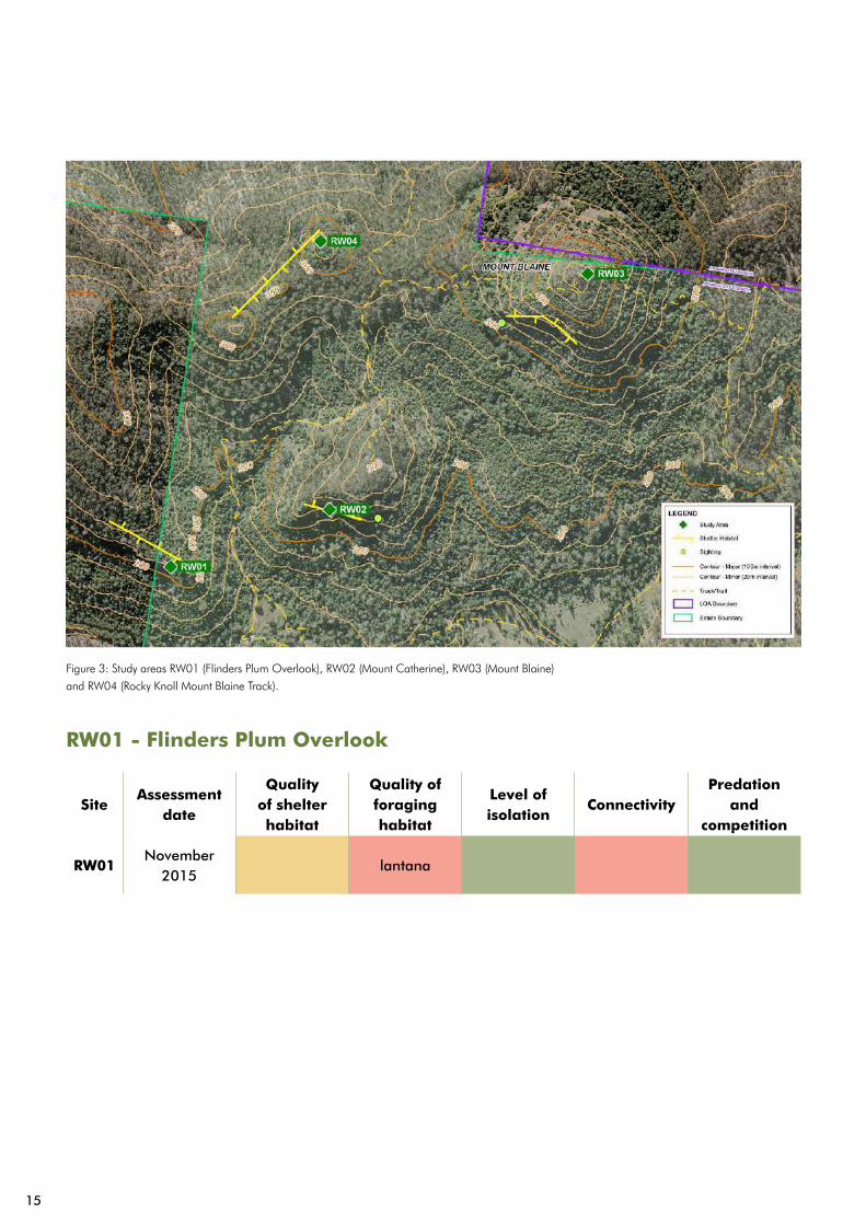
RW01 - Flinders Plum Overlook
SiteAssessment
date
Quality of shelter habitat
Quality of foraging habitat
Level of isolation
ConnectivityPredation
and competition
RW01November
2015lantana
Figure 3: Study areas RW01 (Flinders Plum Overlook), RW02 (Mount Catherine), RW03 (Mount Blaine)
and RW04 (Rocky Knoll Mount Blaine Track).
15
Management objectives
Control pest plants to re-establish the area as suitable rock wallaby habitat.
Increase connectivity between neighbouring rock wallaby study areas (RW01- RW04).
Regional ecosystem
12.8.20 (Shrubby woodland with Eucalyptus racemosa subsp. racemosa or E. dura on Cainozoic igneous rocks) and 12.8.24 (Corymbia citriodora subsp. variegata open forest on Cainozoic igneous rocks especially trachyte).
Approximate elevation
245m
Terrain
Cliff line, scree, not enough ledges or shelter.
Description
Complex rocky outcrop with scree below, just north of the Flinders Plum Picnic Area and west of Mt Catherine.
Evidence of use
No previous evidence of brush-tailed rock wallaby presence. The last visit in 2013 revealed no evidence of rock wallaby presence.
Habitat quality
The site is heavily infested with Lantana camara and there is limited shelter habitat.
Threats
• Infestation of Lantana camara supressing suitable foraging habitat,
• It is within 200m of Flinders Plum Picnic Area,
• Identified as a potentially suitable rock climbing site,
• Difficult movement corridors to other suitable habitat.
Actions
Nominate the site for lantana control under Council’s Conservation Works Program, with works to commence before 2020.
Revisit the site every two years to search for evidence of brush-tailed rock wallaby.
Undertake surveys and desktop analysis to identify potential movement corridors between neighbouring study areas (RW01- RW04). The survey to be completed by June 2018.
16

RW02 - Mount Catherine
SiteAssessment
date
Quality of shelter habitat
Quality of foraging habitat
Level of isolation
ConnectivityPredation
and competition
RW02November
2015regenerating
Mt Catherine/Mt Blaine
Hiking Track
17

Management objectives
Monitor and mitigate potential impacts from recreational use.
Increase connectivity between neighbouring rock wallaby study areas (RW01- RW04).
Regional ecosystem
12.8.19 (Heath and rock pavement with scattered shrubs or open woodland on Cainozoic igneous hills and mountains).
Approximate elevation
240m
Terrain
Cliffs and rock stacks.
Description
Small peak near Flinders Plum Picnic Area with the cliff line on the southern face. The area is largely scree, with not enough ledges or shelter for rock wallabies.
Evidence of use
Previous live sightings from pre-2000. Surveys in 2013 identified no evidence of wallabies.
Habitat quality
The site has reasonable foraging vegetation, but a lot of regeneration. Caves can be seen on the southern cliffs.
Threats
• It is within 350m of Flinders Plum Picnic Area,
• Identified as a potentially suitable rock climbing site,
• Lantana infestation surrounding the site restricting movement corridors,
• Difficult movement corridors to other suitable habitat.
Actions
Revisit the site every two years to search for evidence of brush-tailed rock wallabies.
Undertake surveys and desktop analysis to identify potential movement corridors between neighbouring study areas (RW01- RW04), with the survey to be completed by June 2018.
Undertake site inspections prior to any recreational embellishment to determine potential impacts and to propose mitigation measures.
18

RW03 - Mount Blaine
SiteAssessment
date
Quality of shelter habitat
Quality of foraging habitat
Level of isolation
ConnectivityPredation
and competition
RW03November
2015lantana
19

Management objectives
Monitor and mitigate potential impacts from recreational use.
Increase connectivity between neighbouring rock wallaby study areas (RW01- RW04).
Regional ecosystem
12.8.4 (Complex notophyll vine forest with Araucaria spp. on Cainozoic igneous rocks).
Approximate elevation
455m
Terrain
Rugged, scree climbing to the top, with sheer cliffs with numerous caverns and outcrops.
Description
Pyramid shaped peak, with few large trees on the western side. Denser notophyll scrub on the eastern side. Sheer cliff line on the southern side.
Evidence of use
Previous live sightings from early 2000s. No Council surveys completed due to uncertain access.
Habitat quality
Caves visible on the southern facing cliffs with surrounding vegetation degraded with lantana infestation. The western side is thick with native holly and lantana and the eastern side is comprised mainly of patchy dry rainforest.
Threats
• Moderate levels of Lantana camara infestation,
• Identified as a potentially suitable rock climbing site,
• Difficult movement corridors to other suitable habitat.
Actions
Investigate the area for safe access to cliffs, with likely habitat identified by December 2017.
Conduct initial survey to determine presence and activity of brush-tailed bush-wallabies by December 2017.
Undertake surveys and desktop analysis to identify potential movement corridors between neighbouring study areas (RW01- RW04), with a survey to be completed by June 2018.
20

21
RW04 - Rocky Knoll Mount Blaine Track
Management objectives
Control pest plants to reengage the area as suitable rock wallaby habitat.
Increase connectivity between neighbouring rock wallaby study areas (RW01- RW04).
Regional ecosystem
12.8.20 (Shrubby woodland with Eucalyptus racemosa subsp. racemosa or E. dura on Cainozoic igneous rocks) and 12.8.24 (Corymbia citriodora subsp. variegata open forest on Cainozoic igneous rocks especially trachyte).
Approximate elevation
325m
Terrain
Moderately difficult rocky outcrops and ridgelines.
Description
Small rocky ridge off to the west from Mt Blaine Track. While there are small rocky outcrops, there are not enough serious drops for protection.
Evidence of use
Some evidence of older scats and evidence of other large competing macropods. No live sightings of brush-tailed rock wallaby recorded and therefore overall, unclear evidence of brush-tailed rock wallaby use.
Habitat quality
Detailed habitat assessment not available.
Threats
N/A
Actions
Nominate the site for lantana control under Council’s Conservation Works Program, with works to be undertaken before 2020.
Revisit site every two years to search for evidence of brush-tailed rock wallaby.
Undertake desktop surveys and desktop analysis to identify potential movement corridors between neighbouring study areas (RW01- RW04), with the survey to be completed by June 2018.
22
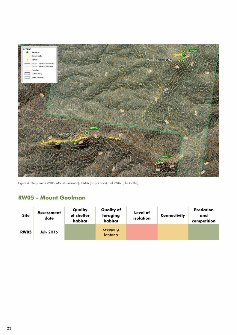
RW05 - Mount Goolman
SiteAssessment
date
Quality of shelter habitat
Quality of foraging habitat
Level of isolation
ConnectivityPredation
and competition
RW05 July 2016creeping lantana
Figure 4: Study areas RW05 (Mount Goolman), RW06 (Ivory’s Rock) and RW07 (The Galley).
23

Management objectives
Maintain movement and connectivity between RW05 and RW06-RW07.
Improve the health of foraging habitat available on the northern face of Mount Goolman.
Investigate the need and means to improve genetic diversity within the study area.
Regional ecosystem
12.8.24 (Corymbia citriodora subsp. variegata, Eucalyptus crebra +/- E. moluccana open forest).
Approximate elevation
455m
Terrain
Steep, rugged ridges and cliffs.
Description
Northern and southern aspect with rocky cliffs, caves and outcrops. The northern face has known sightings but is infested with Lantana montedivensis. The southern face is rocky heath vegetation with epiphyte vegetation up the cliff face. There are caves identified on eastern face and limited public access to the site.
Evidence of use
Historic live sightings on the northern and southern faces. There have been recent live sightings from the northern face. There is also old and fresh scat evidence on the northern face, as well as numerous tracks, skulls and polished rocks.
Habitat quality
High potential for a permanent rock wallaby colony on the northern and north-eastern faces. The northern face is currently heavily degraded due to infestations of creeping lantana. The southern side infested with walls of Lantana camara. There is high quality shelter habitat, due to caves and overhangs on numerous aspects.
Threats
• High levels of weed infestation,
• Old evidence of fire on site, but no fire history recorded in Council system,
• Isolation, genetic diversity and potential for inbreeding depression.
Actions
Undertake works to reduce Lantana montedivensis cover on the site to less than 10% by June 2019.
Continue to monitor and respond to new infestations of weed species, to facilitate the recovery of grassy understory.
Conduct a study of brush-tailed rock wallaby movement patterns around Mt Goolman to determine the level of connectivity.
24
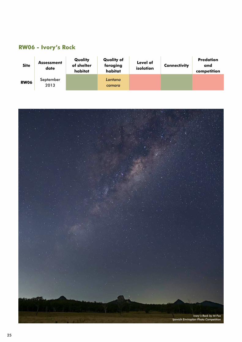
RW06 - Ivory’s Rock
SiteAssessment
date
Quality of shelter habitat
Quality of foraging habitat
Level of isolation
ConnectivityPredation
and competition
RW06September
2013Lantana camara
Ivory’s Rock by M FoxIpswich Enviroplan Photo Competition
25

Management objectives
Encourage and support regular monitoring and predator control on private land and adjoining populations.
Regional ecosystem
12.8.20 (Shrubby woodland with Eucalyptus racemosa subsp. racemosa or E. dura on Cainozoic igneous rocks) and 12.8.19 (Heath and rock pavement with scattered shrubs or open woodland on Cainozoic igneous hills and mountains).
Approximate elevation
360m
Terrain
Steep rocky outcrop with scree.
Description
Long rugged ridge line, cliffs and buttresses with montane heath and dry eucalypt forest. A defined ridgeline connects RW06 - RW07. The study area owned is owned by Ivory’s Rock Conference Centre.
Evidence of use
Variety of scat classes observed, including fresh and old scats. One live sighting was observed in the 2013 surveys. Worn and polished rock also located in a variety of areas; however no den sites have been located.
Habitat quality
Infestations of lantana around the base of the rocky shelter, with limited forb and montane heath through the complex rocky habitat sections. There is a steep rocky ridgeline and outcrop with rocky scree, which creates complex habitat suitable for shelter.
Threats
• Limited public access,
• Evidence of feral goats on site,
• Lantana camara infestation
Actions
Revisit the site with the landholder every two years, to search for evidence of brush-tailed rock wallaby.
Provide support for the landholder through the Landholder Partnerships Program. Provide assistance for revegetation and habitat management through grants and assistance for pest management, through the provision of traps and technical advice.
26

RW07 - The Gallery
SiteAssessment
date
Quality of shelter habitat
Quality of foraging habitat
Level of isolation
ConnectivityPredation
and competition
RW07September
2013Lantana camara
feral goats
27

Management objectives
Encourage and support regular monitoring and predator control on private land and adjoining populations.
Regional ecosystem
12.8.20 (Shrubby woodland with Eucalyptus racemosa subsp. racemosa or E. dura on Cainozoic igneous rocks) and 12.8.19 (Heath and rock pavement with scattered shrubs or open woodland on Cainozoic igneous hills and mountains).
Approximate elevation
360m
Terrain
Steep rocky outcrop with a cliff line below ridge.
Description
Cliff line below a defined ridgeline, which connects to the main study areas in Ivory’s Rock conference centre (RW06). The study area is owned by Ivory’s Rock Conference Centre.
Evidence of use
There have been no live sightings recorded at this study area. Low to moderate levels of scats have been recorded during 2013 survey and fresh scat recorded on the previous search.
Habitat quality
There are infestations of lantana around the base of the rocky shelter. There is limited forb and montane heath through the complex rocky habitat sections. The steep rocky ridgeline and outcrop with rocky scree creates complex habitat, suitable for shelter.
Threats
• Limited public access,
• Evidence of feral goats on site,
• Lantana camara infestation.
Actions
Revisit the site every two years to search for evidence of brush-tailed rock wallaby.
Provide support for the landholder through the Landholder Partnerships Program. Provide assistance for revegetation and habitat management through grants and assistance for pest management, through the provision of traps and technical advice.
28
Management objectives
Re-establish a breeding colony that permanently resides within the site.
Facilitate the recovery of foraging habitat suitable for retention of a long term population.
Maintain connectivity with RW11 and the remainder of Flinders Peak.
Regional ecosystem
12.8.9 (Lophostemon confertus open forest on Cainozoic igneous rocks) and 12.8.24 (Corymbia citriodora subsp. variegata open forest on Cainozoic igneous rocks especially trachyte).
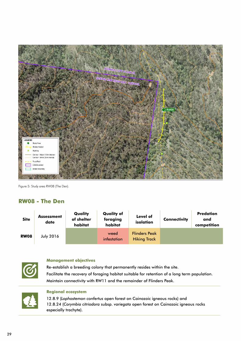
RW08 - The Den
SiteAssessment
date
Quality of shelter habitat
Quality of foraging habitat
Level of isolation
ConnectivityPredation
and competition
RW08 July 2016weed
infestationFlinders Peak Hiking Track
Figure 5: Study area RW08 (The Den).
29

Approximate elevation
595m
Terrain
Cliffs, rock stacks, caves, ledges and overhangs.
Description
A ridge running approximately west from Flinders Saddle with extensive cliffs below the western ridge and some isolated rock stacks.
Evidence of use
Widespread brush-tailed rock wallaby activity on top of the ridge, with some activity and live sightings recorded below the ridge. There is a high level historic use, with a high density of old scats and shiny rocks within the known den site. Numerous sightings of rock wallabies, including pouched young, on monitoring cameras from 2013-2017, suggest that animals in the area are not currently using the site for denning but are returning periodically to investigate the area.
Habitat quality
There is access to water and a good mosaic of vegetation types and age classes, with vine thicket moving into open eucalypt forest. There is a good diversity of dry rainforest species, germinating throughout the site and patches of native groundcover, including foraging species (e.g. Themeda triandra) that will support native regeneration. The site is highly resilient with a good soil seed bank, despite high levels of weed infestation. There is a high quality shelter habitat, with numerous caves and undercuts. Major overhangs have flight paths in multiple directions. There is excellent connectivity to extensive natural areas in all directions, including other rock systems, likely to support brush-tailed rock wallaby.
Threats
• High levels of weed infestation and reduced foraging amenity,
• High public access including reports of recreational rock climbing,
• Some fire impacts,
• An inactive fox den in the gully, but no other sign of fox activity recorded.
Actions
Undertake works to reduce weed infestation on site to below 10% by the end of 2018. Monitor the recovery of native fodder and prescribe further restoration actions accordingly.
Undertake regular monitoring of the den sites and of downslope foraging areas, to track changes in rock wallaby usage.
Undertake regular and targeted fox monitoring within the site. Any signs of fox predation are to be immediately followed by actions to remove foxes from the area. Any predator scats located are sent for content analysis.
Regularly monitor access points to den sites for presence of recreational users of the park and implement actions to reduce visitor impact where necessary.
30
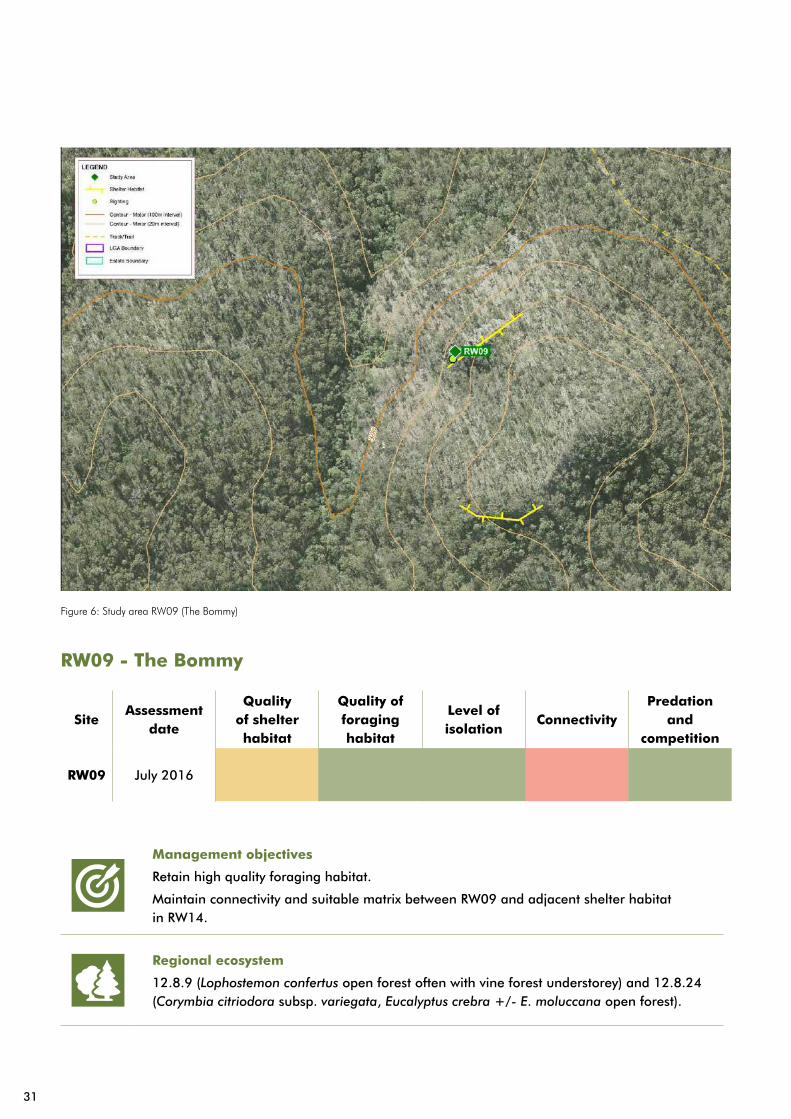
RW09 - The Bommy
SiteAssessment
date
Quality of shelter habitat
Quality of foraging habitat
Level of isolation
ConnectivityPredation
and competition
RW09 July 2016
Figure 6: Study area RW09 (The Bommy)
Management objectives
Retain high quality foraging habitat.
Maintain connectivity and suitable matrix between RW09 and adjacent shelter habitat in RW14.
Regional ecosystem
12.8.9 (Lophostemon confertus open forest often with vine forest understorey) and 12.8.24 (Corymbia citriodora subsp. variegata, Eucalyptus crebra +/- E. moluccana open forest).
31
Approximate elevation
360m
Terrain
Rocky outcrop on the side of a knoll.
Description
Two separate rocky ridgelines with brush box forest in between them. The northern ridge has evidence of rock wallabies, and the southern ridge is yet to be investigated. The northern ridge is more complex with large boulders, steep rocky pinnacles, ledges and small north facing caves.
Evidence of use
Live sightings as recent as 2013 detected with an on-trail camera. Fresh scat evidence has been identified on several occasions between 2014 and 2017.
Habitat quality
Highly suitable foraging habitat with expansive areas of native grass and rocky areas with montane forbs. The area has highly suitable rocky habitat for temporary shelter, with boulders and small caves, though it is unlikely to be suitable for permanent shelter habitat. It is reasonably close to other offsite shelter habitat and suitable for feeding.
Threats
• Moderate levels of weed infestation limited to lower areas, around the base of the rocks and with prickly pear along the ridges,
• Possible competition from other macropods.
Actions
Monitor vegetation health to determine and record any declines in quality.
Conduct cool prescribed fire, to maintain grass health. Fires prescribed based on visible signs of grass heath decline with consideration to fire regimes, fire history and the ‘Ipswich Fire Management Strategic Plan’.
Undertake regular and targeted fox monitoring within the site (targeted in the valley between RW09 and RW14). Any signs of fox predation are to be immediately followed by actions to remove foxes from the area. Any predator scats are to be sent for content analysis.
32

RW10 - Scott’s Scrub Pinnacle
SiteAssessment
date
Quality of shelter habitat
Quality of foraging habitat
Level of isolation
ConnectivityPredation
and competition
RW10December
2015
Figure 7: Study area RW10 (Scott’s Scrub Pinnacle).
33

Management objectives
Periodically monitor the site to detect any future use by brush-tailed rock wallaby.
Regional ecosystem
12.9-10.7 (Eucalyptus crebra +/- E. tereticornis, Corymbia tessellaris, Angophora spp., E. melanophloia woodland on sedimentary rocks) and 12.9-10.2 (Corymbia citriodora subsp. variegata +/- Eucalyptus crebra open forest on sedimentary rocks) and 12.9-10.17 (Eucalyptus acmenoides, E. major, E. siderophloia +/- Corymbia citriodora subsp. variegata woodland on sedimentary rocks).
Approximate elevation
450m
Terrain
Very steep, complex ledges and an isolated rocky peak.
Description
A small rocky outcrop, potentially not isolated enough or and lacking sufficient shelter for rock wallabies.
Evidence of use
No evidence of rock wallabies in two separate visits (last visit December 2015). There is evidence of swamp wallabies all across the study area, including directly below the rocky outcrop.
Habitat quality
Highly suitable foraging habitat with expansive areas of native grass and rocky areas with montane forbs. Rocky outcrop lacks suitable caves and overhangs to constitute quality shelter habitat.
Threats
• Potential competition with other macropods,
• Limited shelter increases vulnerability to fox predation.
Actions
Revisit site every two years to search for evidence of brush-tailed rock wallaby.
34

RW11 - The Descent
SiteAssessment
date
Quality of shelter habitat
Quality of foraging habitat
Level of isolation
ConnectivityPredation
and competition
RW11December
2015cave trail feral pigs
Figure 8: Study areas RW11 (The Descent), RW12 (Mount Flinders Saddle) and RW13 (Roads End).
Management objectives
Improve foraging habitat quality.
Ensure that local populations do not suffer from predation from European red foxes.
Monitor and mitigate potential impacts from recreational use.
Regional ecosystem
12.8.9 (Lophostemon confertus open forest with vine forest understory) and 12.8.24 (Corymbia citriodora subsp. variegata, Eucalyptus crebra +/- E. moluccana open forest).
35

Approximate elevation
380m
Terrain
Mix of steep overgrown terrain, with limited rock scrambling and small scree areas.
Description
There are two separate rocky ridgelines and several other outcrops to the east of the Flinders Peak hiking track. Ridgelines run adjacent to each other and are roughly 150m apart.
Evidence of use
At least six live sightings have been recorded, spanning 1996-2016. A moderate level of scat has been recorded in various areas from 2015 surveys. There has been more scat evidence recorded in 2016 surveys.
Habitat quality
High potential foraging habitat but degraded. There is limited refuge habitat within the site but high quality shelter habitat nearby, which would support a permanent colony. There site has high levels of pig damage in areas and there are camera images of pigs recorded on site.
Threats
• Medium to high levels of feral pig activity destroying foraging habitat,
• Fire impacts,
• Moderate levels of weed infestation impacting development of native vegetation recovering from fire,
• Flinders Peak Hiking Track immediately adjacent with low public access to site.
Actions
Measure levels of feral pig activity every six months, to determine the level of pig use on the saddle and on the Havill Track up to the QTFN Koala Crossing Boundary.
Target pig control on Havill Track when pig activity is noted, and use the dam on the eastern side of the peak as an alternative trapping site, and coordinate the pig control with QTFN.
Undertake regular and targeted fox monitoring within the site. Any signs of fox predation are to be immediately followed by actions to remove foxes from the area. Any predator scats are to be sent for content analysis.
Manually modify vegetation to restore habitat structure more suited to brush-tailed rock wallaby foraging. Target monocultures of Acacia fimbriata, inkweed and Lantana montedivensis and use chemical control or fire applied, where practical and appropriate. Initial work completed by December 2019 with follow up work to trial a mixture of direct seeding and planting of suitable forage species.
36

RW12 - Mount Flinders Saddle
SiteAssessment
date
Quality of shelter habitat
Quality of foraging habitat
Level of isolation
ConnectivityPredation
and competition
RW12 July 2016Lantana camara
Feral goats
Management objectives
Improve foraging habitat quality on Mount Flinders Saddle and downslope areas.
Ensure that local populations do not suffer from predation from European red foxes.
Monitor and mitigate potential impacts from recreational use.
Regional ecosystem
12.8.9 (Lophostemon confertus open forest with vine forest understory) and 12.8.24 (Corymbia citriodora subsp. variegata, Eucalyptus crebra +/- E. moluccana open forest).
Approximate elevation
595m
Terrain
Cliffs, rock stacks, caves, ledges and overhangs.
Description
A ridge running west from Flinders saddle. There are extensive cliffs below the western ridge, with some isolated rock stacks. Rock stacks are on top of the ridge and there are several caves below cliff line.
Evidence of use
Widespread brush-tailed rock wallaby activity on top of the ridge. Some activity and live sightings have been recorded below the ridge. Whilst a den site is not known, there have been observations of brush-tailed rock wallaby with pouch young at this site. Fresh and recent, high scat density in places, especially on exposed rocky outcrops used for winter basking.
37
Habitat quality
Refuge habitat is surrounded by native vegetation on all sides. Fire impacts including loss of canopy and species diversity in important areas of the site, such as potential brush-tailed rock wallaby foraging habitat areas. There is considerable pig damage, particularly on the south facing slope below the site and around rocky habitat in the south-western corner of the site. The site has high suitability as a permanent rock wallaby colony, but is currently affected by several disturbance factors.
Threats
• Moderate levels of weed infestation,
• High level of feral pig damage,
• Changes to vegetation structure due to fire,
• The Flinders Peak Hiking Track is immediately adjacent; thought there is low public access to site.
Actions
Measure levels of feral pig activity every six months to determine level of pig use on the saddle and on Havill Track up to the QTFN Koala Crossing Boundary.
Target pig control on Havill Track when pig activity is noted, using the dam on the eastern side of the peak as an alternative trapping site, and coordinate pig control with QTFN.
Undertake regular and targeted fox monitoring within the site. Any signs of fox predation are immediately followed by actions to remove foxes from the area. Any predator scats are sent for content analysis.
Manually modify vegetation to restore habitat structure more suited to brush-tailed rock wallaby foraging. Target monocultures of Acacia fimbriata, inkweed and Lantana montedivensis and use chemical control or fire applied, where practical and appropriate with initial work to be completed by December 2019.
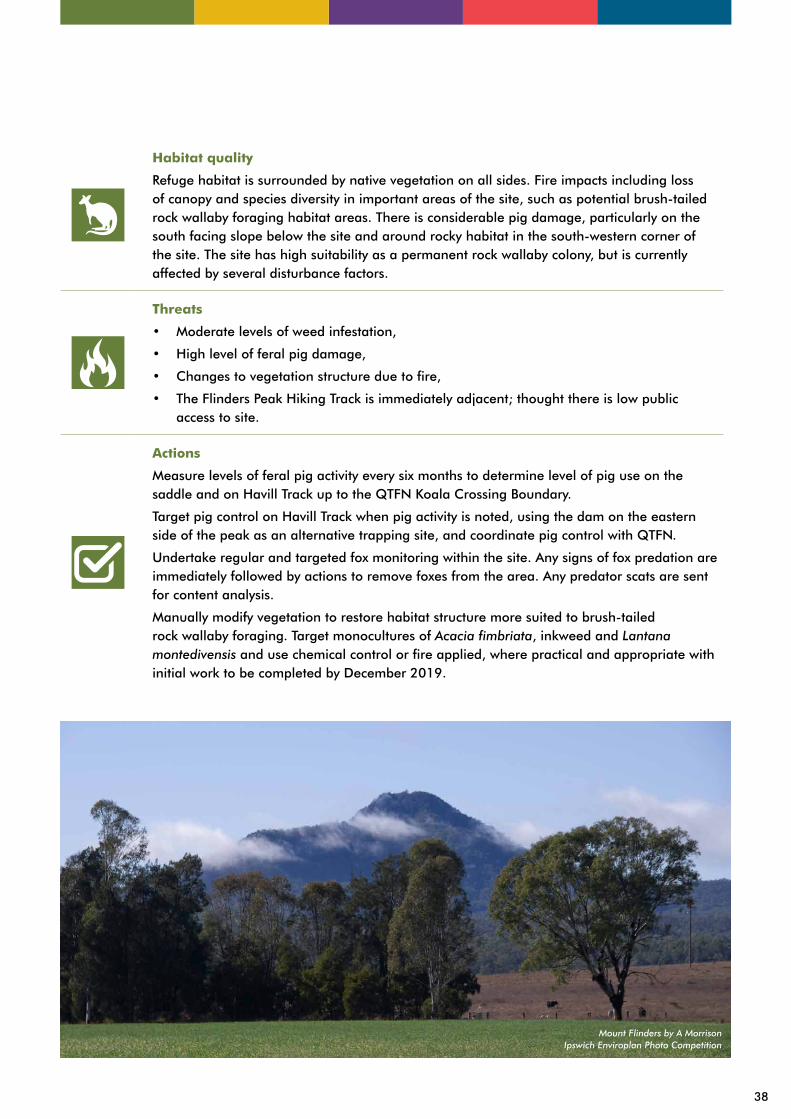
Mount Flinders by A MorrisonIpswich Enviroplan Photo Competition
38

RW13 - Roads End
SiteAssessment
date
Quality of shelter habitat
Quality of foraging habitat
Level of isolation
ConnectivityPredation
and competition
RW13September
2016feral goats
39
Management objectives
Retain high quality foraging habitat.
Regional ecosystem
12.8.9 (Lophostemon confertus open forest with vine forest understory) and 12.8.24 (Corymbia citriodora subsp. variegata, Eucalyptus crebra +/- E. moluccana open forest).
Approximate elevation
380m
Terrain
Steep slope access from the southern side of Flinders Peak. The site has a smooth, moderately sloped rocky outcrop at the top.
Description
The site is a prominent rocky knoll on top of a ridgeline, running south-west from Flinders Peak. Overhang on the northern side of the outcrop.
Evidence of use
No evidence recorded in two separate site visits in 2016.
Habitat quality
Mixed quality of foraging habitat with several open grassed areas, and areas with thick Acacia regrowth supressing grass. The site also has moderate to high levels of pig activity, destroying understory vegetation. The rocky outcrop lacks complexity, and overhang does not present sufficient shelter for a permanent den.
Threats
• Potential for competition with other wallabies, most notably swamp wallabies,
• Destruction of foraging habitat by feral pigs,
• Minimal public access,
• Fire impacts on vegetation structure,
• Moderate levels of weed infestation,
• No evidence of fox predation recorded.
Actions
Monitor vegetation health every two years to determine and record any decline in quality.
Conduct cool prescribed fire to maintain grass health and prescribe fires based on visible signs of grass heath decline with consideration to fire regimes, fire history and the ‘Ipswich Fire Management Strategic Plan’.
40

Figure 9: Study area RW14 (Flinders Peak North East), RW15 (Flinders Peak Summit), RW16 (Flinders Peak East Ridge) and RW17 (Flinders Foot).
41

RW14 - Flinders Peak North East
Management objectives
Obtain baseline data.
Regional ecosystem
12.8.9 (Lophostemon confertus open forest with vine forest understory) and 12.8.24 (Corymbia citriodora subsp. variegata, Eucalyptus crebra +/- E. moluccana open forest).
Approximate elevation
420m
Terrain
Unknown, needs investigating.
Description
Prominent complex rocky outcrops with a north-eastern aspect down slope from Flinders Peak.
Evidence of use
No evidence currently but highly suitable habitat. No surveys have been conducted.
Habitat quality
Detailed habitat assessment not available.
Threats
Detailed threat assessment not available.
Actions
Investigate area for safe access to cliffs with likely habitat.
Conduct initial survey to determine presence and activity of brush-tailed rock wallaby.
42

RW15 - Flinders Peak Summit
SiteAssessment
date
Quality of shelter habitat
Quality of foraging habitat
Level of isolation
ConnectivityPredation
and competition
RW15 June 2014
43
Management objectives
Periodically monitor the site to detect any future use by brush-tailed rock wallaby.
Regional ecosystem
12.8.19 (Heath and rock pavement with scattered shrubs or open woodland on Cainozoic igneous hills and mountains).
Approximate elevation
670m
Terrain
Complex, steep rocky outcrops (some isolated), with loose rock and scree.
Description
Rock stacks, cliffs, caves and potential den sites in upper slopes. There are grassy areas in lower slopes, rock stacks, overhangs, caves (1 containing probable scat) and upper slopes.
Evidence of use
Recent and fresh scat, density increasing in upper rocky areas with moderate scat density. A live sighting was recorded in 2008.
Habitat quality
Several grassy slopes in the area present highly suitable foraging areas. Rock stacks, scree, overhangs and caves are present throughout the site, whichpresent highly suitable shelter habitat.
Threats
• High level of public access to several areas,
• Some potential disturbance from recreational rock climbers using the area,
• No feral pig activity recorded,
• No evidence of red fox recorded on site.
Actions
Monitor vegetation health to determine and record any declines in quality.
Conduct cool prescribed fire to maintain grass health and prescribe fire based on visible signs of grass heath decline, with consideration to fire regimes, fire history and the ‘Ipswich Fire Management Strategic Plan’.
44
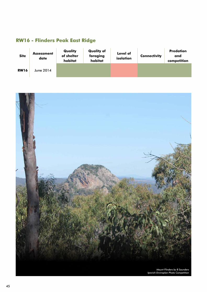
RW16 - Flinders Peak East Ridge
SiteAssessment
date
Quality of shelter habitat
Quality of foraging habitat
Level of isolation
ConnectivityPredation
and competition
RW16 June 2014
Mount Flinders by B SaundersIpswich Enviroplan Photo Competition
45
Management objectives
Periodically monitor the site to detect any future use by brush-tailed rock wallaby.
Regional ecosystem
12.8.19 (Heath and rock pavement with scattered shrubs or open woodland on Cainozoic igneous hills and mountains).
Approximate elevation
670m
Terrain
Complex, steep rocky outcrops (some isolated), with loose rock and scree.
Description
Rock stacks, cliffs, caves and potential den sites in upper slopes. There are grassy areas in lower slopes, rock stacks, overhangs, caves (1 containing probable scat) and upper slopes.
Evidence of use
Recent and fresh scat, density increasing in upper rocky areas with moderate scat density. A live sighting was recorded in 2008.
Habitat quality
Several grassy slopes in the area present highly suitable foraging areas. Rock stacks, scree, overhangs and caves are present throughout the site, which present highly suitable shelter habitat.
Threats
• High level of public access to several areas,
• Some potential disturbance from recreational rock climbers using the area,
• No feral pig activity recorded,
• No evidence of red fox recorded on site.
Actions
Monitor vegetation health to determine and record any declines in quality.
Conduct cool prescribed fire to maintain grass health and prescribe fire based on visible signs of grass heath decline, with consideration to fire regimes, fire history and the ‘Ipswich Fire Management Strategic Plan’.
46
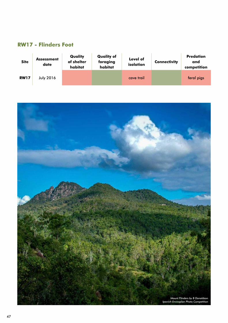
RW17 - Flinders Foot
SiteAssessment
date
Quality of shelter habitat
Quality of foraging habitat
Level of isolation
ConnectivityPredation
and competition
RW17 July 2016 cave trail feral pigs
Mount Flinders by B DonaldsonIpswich Enviroplan Photo Competition
47
Management objectives
Retain high quality foraging habitat.
Regional ecosystem
12.8.9 (Lophostemon confertus open forest with vine forest understory) and 12.8.24 (Corymbia citriodora subsp. variegata, Eucalyptus crebra +/- E. moluccana open forest).
Approximate elevation
N/A
Terrain
Rocky outcrops and small cliffs with limited complexity.
Description
Small rocky outcrop off the Havill Track in the south of Flinders-Goolman Conservation Estate.
Evidence of use
None observed, but the cliffs and caves are largely inaccessible.
Habitat quality
The site contains rocky outcrops with some potential shelter areas between boulders in the southern corner of site. Towards the centre of the site, there are mainly sheer slopes with limited shelter opportunities. Fire has impacted parts of the site and has killed off the canopy though regeneration of native species, including brush box and Acacia species is preventing weed colonisation and growth.
Threats
• Low weed density and limited to south-eastern corner of the site,
• Evidence of pig activity to the south of the site,
• No evidence of other pest animals recorded,
• Fire impacts,
• Limited public access.
Actions
Monitor vegetation health every two years to determine and record any declines in quality.
Conduct cool prescribed fire to maintain grass health and prescribe fire based on visible signs of grass heath decline, with consideration to fire regimes, fire history and the ‘Ipswich Fire Management Strategic Plan’.
48
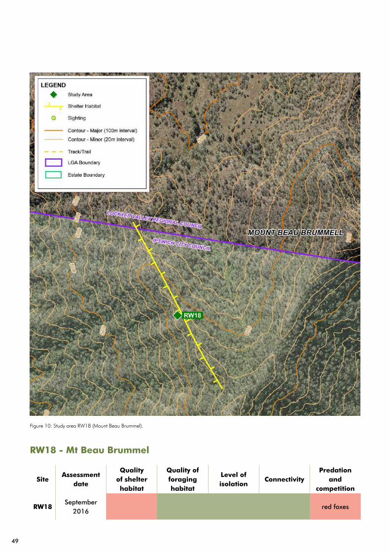
Figure 10: Study area RW18 (Mount Beau Brummel).
SiteAssessment
date
Quality of shelter habitat
Quality of foraging habitat
Level of isolation
ConnectivityPredation
and competition
RW18September
2016red foxes
RW18 - Mt Beau Brummel
49

Management objectives
Determine the status of the cliff line, to the west of Mt Beau Brummel.
Coordinate the management by and support conservation efforts undertaken by the Queensland Trust for Nature.
Regional ecosystem
12.8.16 (Eucalyptus crebra +/- E. melliodora, E. tereticornis woodland on Cainozoic igneous rocks) and 12.8.17 (Eucalyptus melanophloia +/- E. crebra, E. tereticornis, Corymbia tessellaris woodland on Cainozoic igneous rocks).
Approximate elevation
630m
Terrain
Steep climb to the top of the ridge.
Description
Prominent ridgeline following Mt Beau Brummel on Little Liverpool Range.
Evidence of use
Three historic sightings from 1997 found on Wildnet. No scats or other evidence recorded during surveys in 2016. The neighbouring Queensland Trust for Nature has recorded regular evidence of rock wallabies, including breeding activity. This confirms that rock wallabies are still present along the Little Liverpool Range.
Habitat quality
The southern face of Mt Beau Brummel contains pristine quality foraging habitat, with thick native grass and a variety of shrubs and forbs around the higher rocky areas. Limited shelter habitat has been identified on Mt Beau Brummel itself. Although yet to be surveyed, the cliff lines to the west are likely to exhibit suitably complex shelter habitat.
Threats
• Minimal to no public access,
• Fire impacts on vegetation structure,
• Minimal weed infestation,
• Evidence of fox predation at the peak of Mt Beau Brummel.
Actions
No actions
50

Figure 11: Study area RW19 (White Rock – Spring Mountain Conservation Estate).
SiteAssessment
date
Quality of shelter habitat
Quality of foraging habitat
Level of isolation
ConnectivityPredation
and competition
RW18September
2016
RW19 - White Rock-Spring Mountain Conservation Estate
51

Management objectives
Periodically monitor the site to detect any future use by the brush-tailed rock wallaby.
Regional ecosystem
12.9-10.19a (Eucalyptus fibrosa subsp. fibrosa woodland on sedimentary rocks).
Approximate elevation
350m
Terrain
Cliffs, rock stacks, caves, ledges and overhangs.
Description
A long, complex rocky ridgeline running north to south at the very south of the White Rock - Spring Mountain Conservation Estate. There are vast areas of highly suitable foraging habitat in the areas to the east and west of the ridgeline. Periodic caves and overhangs are present along the length of the ridgeline facing east and north-east.
Evidence of use
Evidence of long historic use within east facing caves, based on the polish on rock faces. However, obtaining evidence of wear within caves was more difficult than normal due to weathered sandstone parent rock. No current evidence found on rock stacks or in caves. There is evidence of pretty face and swamp wallaby along the length of the ridgeline.
Habitat quality
Extremely high quality foraging habitat. There are large areas of grassy understory, xanthorreas and a diverse range of shrubs. There are also a variety of eastern facing sandstone caves spanning approximately 1km along a ridgeline running north to south.
Threats
• No evidence of red foxes in the area (needs further investigation),
• Evidence of feral pigs with minimal damage,
• No impacts from fire,
• Minimal to no public access.
Actions
Revisit site every two years to search for evidence of brush-tailed rock wallaby.
Conduct more detailed investigations to determine the cause of current absence.
Investigate the potential for this location to be a release site for captive breeding programs.
52

Implementation
Actions are prioritised based on several factors, primarily:
• Level of threat at a study area,
• Type of threat,
• Previous evidence of use at a study area,
• Recovery potential,
• Objectives of the study area.
For example, an action within a high threat area that has a long history of use and high recovery potential is considered a high priority action. Where an action is proposed in an area with high threat and limited historic usage, it is considered to have lower recovery value and will be a lower priority.
Table 2 lists all actions that have been prescribed, including the year of proposed implementation. Several actions are to be implemented across various study areas, or may simultaneously affect more than one at a time.
The last column in Table 2 lists measures that will be used to determine the action success upon implementation. For the majority of actions that involve habitat improvement or active threat mitigation, changes to the habitat assessment will be used to measure success.
Table 2: Complete List of Actions and Locations for Implementation
Action Study area(s) Measure
Nominate the site for lantana control under Council’s Conservation Works Program. Works to be undertaken before 2020.
RW01, RW04Each site is given a high for habitat quality.
Revisit site every two years to search for evidence of brush-tailed rock wallaby.
RW01, RW02, RW04, RW06, RW07
Surveys are undertaken.
Identify potential movement corridors between neighbouring study areas (RW01-RW03, RW07). Survey to be completed by June 2018.
RW01, RW02, RW03, RW04, RW06, RW07 RW10
Level of connectivity is increased to moderate at all sites.
Undertake site inspections prior to any recreational embellishment to determine potential impacts and propose mitigation measures.
RW02Level of isolation is kept to moderate.
Investigate area for safe access to cliffs with likely habitat by December 2017.
RW03, RW14
Low impact from feral predators and/or medium to low competition from feral herbivores
Undertake works to reduce weed infestation on site to below 10% by the end of 2018. Monitor the recovery of native fodder and prescribe further restoration actions accordingly.
RW08Quality of foraging habitat is improved to high.
53

Action Study area(s) Measure
Undertake regular monitoring of den sites and of downslope foraging areas to tracks changes in rock wallaby usage.
RW08
Increase in foraging habitat leads to an increase in rock wallaby presence.
Undertake regular and targeted fox monitoring within the site. Any signs of fox predation are immediately followed by actions to remove foxes from the area. Any predator scats locations are sent for content analysis.
RW08, RW09, RW11, RW12, RW14
Level of predation and competition is increased or kept to high (No evidence of competition or predation from feral species).
Regularly monitor access points to den sites for presence of recreational users of the park, and implement actions to reduce visitor impact where necessary.
RW08Level of isolation is improved to moderate.
Undertake works to reduce Lantana montedivensis cover on site to less than 10% by June 2019.
RW05Foraging habitat is improved to moderate.
Continue to monitor and respond to new infestations of weed species to facilitate recovery of grassy understory.
RW05Foraging habitat is improved to moderate.
Conduct study of brush-tailed rock wallaby movement patterns around Mt Goolman to determine level of connectivity.
RW05Level of connectivity is increased to moderate.
Measure levels of feral pig activity every six months to determine level of pig use on the saddle and on Havill Track up to the QTFN Koala Crossing Boundary.
RW11, RW12Level of predation is kept to moderate or improved to high.
Target pig control on Havill Track when pig activity is noted (use dam on eastern side of the peak as an alternative trapping site) and coordinate pig control with QTFN.
RW11, RW12Level of predation is kept to moderate or improved to high.
Manually modify vegetation to restore habitat structure more suited to brush-tailed rock wallaby foraging. Target monocultures of Acacia fimbriata, inkweed and Lantana montedivensis. Chemical control or fire applied where practical and appropriate. Initial work completed by December 2019. Follow up work to trial a mixture of direct seeding and planting of suitable forage species.
RW11, RW12 Foraging habitat quality is improved to high.
54
Action Study area(s) Measure
Monitor vegetation health every two years to determine and record any declines in quality.
RW09, RW13, RW15, RW16, RW17
Foraging habitat quality is kept to high for all sites.
Conduct cool prescribed fire to maintain grass health with fire prescribed based on visible signs of grass heath decline, with consideration to fire regimes, fire history and the ‘Ipswich Fire Management Strategic Plan’.
RW09, RW13, RW15, RW16, RW17
Foraging habitat quality is kept to high for all sites.
Conduct initial survey to determine presence and activity of the brush-tailed rock wallaby.
RW14
Habitat assessment complete and actions prescribed by December 2017.
Conduct more detailed investigations to determine cause of current absence.
RW19 Completion.
Investigate the potential for this location to be a release site for captive breeding programs.
RW19 Completion.
The completion and monitoring of actions will be recorded via a register created from Table 2.
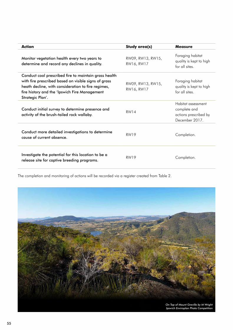
On Top of Mount Greville by M WrightIpswich Enviroplan Photo Competition
55
Priority actionsThis section lists actions by year, to illustrate the order of implementation and delivery. This forms the register of actions for implementation of the plan.
Year 1 (17/18)
• Conduct initial survey to determine presence and activity of the brush-tailed rock wallaby by December 2017 (RW03).
• Identify potential movement corridors between neighbouring study areas (RW01-RW04).
• Conduct initial survey to determine presence and activity of the brush-tailed rock wallaby (RW14).
• Undertake works to reduce weed infestation on site to below 10% by the end of 2018. Monitor the recovery of native fodder and prescribe further restoration actions accordingly (RW08).
Year 2 (18/19)
• Undertake works to reduce Lantana montedivensis cover on site to less than 10% by June 2019 (RW05).
• Conduct a study of brush-tailed rock wallaby movement patterns around Mt Goolman to determine the level of connectivity (RW05).
• Revisit site every two years to search for evidence of brush-tailed rock wallaby (RW01, RW02, RW03, RW04, RW06, RW07, and RW19).
• Conduct more detailed investigations to determine cause of current absence (RW19).
Year 3 (19/20)
• Manually modify vegetation to restore habitat structure more suited to brush-tailed rock wallaby foraging. Target monocultures of Acacia fimbriata, inkweed and Lantana montedivensis. Chemical control or fire applied where practical and appropriate. Initial work completed by December 2019 (RW11, RW12). Follow up work to trial a mixture of direct seeding and planting of suitable forage species.
Year 4 (20/21)
• Nominate the site for lantana control under Council’s Conservation Works Program. Works to be commenced before 2020).
• Revisit site every two years to search for evidence of brush-tailed rock wallaby (RW01, RW02, RW03, RW04, RW19).
Ongoing actions
• Undertake regular monitoring of den sites and of downslope foraging areas to tracks changes in rock wallaby usage (RW08).
• Undertake regular and targeted fox monitoring within the site. Any signs of fox predation are immediately followed by actions to remove foxes from the area. Any predator scats locations are sent for content analysis (RW08, RW09, RW11, RW12, and RW14).
• Measure levels of feral pig activity every six months to determine level of pig use on the saddle and on Havill Track up to the QTFN Koala Crossing Boundary (RW11, RW12).
• Continue to monitor for the presence of feral goats within all sites.
As required
• Undertake site inspections prior to any recreational embellishment to determine potential impacts and propose mitigation measures (RW02).
• Conduct cool prescribed fire to maintain grass health with fire prescribed based on visible signs of grass heath decline, with consideration to fire regimes, fire history and the ‘Ipswich Fire Management Strategic Plan’. Investigate the potential for this location to be a release site for captive breeding programs (RW19).
56

Implementation
Relocation, captive breeding and translocationCaptive breeding has been used as a conservation tool for brush-tailed rock wallabies across much of their range. Populations have been released within the southern and central ESU’s with some successes. There are currently no captive breeding populations within the northern ESU. The University of Queensland are in the process of establishing a wildlife breeding facility at Spicers Hidden Vale. The brush-tailed rock wallaby is one of the species proposed to be included in the program to have breeding populations established.
Council’s role in such programs is providing land, understanding local rock wallaby populations and managing threatening processes. Council also has a role in supporting private landholders with rock wallaby habitat through its Conservation Partnership Program.
Wherever appropriate, captive breeding and release is considered a viable conservation approach. To determine whether release of captive bred animals is suitable in a given location there are a number of guiding principles that are to be followed:
• Subsidising wild populations should only be considered where a conservation need is recognised.
• It must be demonstrated that all local, state and commonwealth legislation has been met.
• Animals are not to be released to a historically used location without investigating and addressing the reason for their current absence.
• Expert input should be sought where releasing into a site with suitable habitat with no historic evidence of use.
• Captive populations are required to be of the same ESU, where subsidising an existing wild population.
• Prior to releasing captive bred animals, sufficient lead time is allowed to make informed decisions and address any relevant risks. This should be 12 months as a minimum.
Community awarenessThe community and members of the public have an important role to play in rock wallaby conservation. Active and engaged communities can lead to increased reporting of sightings, population monitoring and predator and competitor control. The following will be used to promote engagement with the community:
• Expand brush-tailed rock wallaby support groups,
• Facilitate community involvement in the recovery program,
• Provide species and habitat management advice to landholders,
• Publicise results of recovery to the community.
Working with adjacent landholdersMany areas of brush-tailed rock wallaby habitat within the Ipswich local government area are bordered by private landholders with varying land management practices. While the actions prescribed in this plan are primarily tied to a discrete location, there must be consideration of cross boundary influences where threat abatement is required. Council already works with several adjacent landholders including Ivory’s Rock Conference Centre and the Queensland Trust for Nature. Key actions to coordinate include:
• Prescribed burning and wildfire mitigation,
• Pest animal management,
• Stock access and management, and
• Species and habitat monitoring.
57
Monitoring Schedule
Study area monitoringIn addition to searching for signs and active searches for rock wallaby evidence, regular surveys should include:
• A reassessment of the habitat matrix,
• Searches for evidence of pest animals and assess the need for further actions or intervention,
• Search for evidence of other disturbance such as human activity, and
• Determining the status of foraging vegetation and assess the need for further actions or intervention.
The following survey intensity is prescribed for the various study areas:
Twice yearly: RW05, RW09, RW11, RW12 – Plus one run of camera monitoring and surveying for signs.
Yearly: RW08, RW14, RW16, RW19 – Searching for signs.
Every 2 years: RW01, RW02, RW03, RW04, RW06, RW07, RW10, RW13, RW15, RW18 – Searching for signs or inferential evidence.
Table 3 is a minimum recommended effort for each of the survey techniques to be used. This has been adapted from the targeted species survey guideline for Sharman’s Rock Wallaby, as one does not currently exist for P. penicillata (Venz and Rowland 2013).
Table 3: Minimum effort per 5 ha of suitable habitat
Survey technique Minimum effort
Searching for signsTwo hours per survey day
Infra-red camera trappingFive cameras, at least 14 nights
Observation surveysFour hours per survey day
Other inferential evidenceOne hour per survey day
Links with the NAE pest management programMitigating the risks of feral animals and their threats to rock wallaby populations is a major focus of many of the actions within the recovery plan. All actions aimed at reducing this risk will be delivered through the NAE Pest Management Program. When monitoring for pest animals, more frequent and intense effort is required than through study area surveys, especially in the case of predation for European red foxes.
For European red foxes, monitoring is to involve 14 camera nights every three months in areas, as prescribed in the priority actions. Cameras will target areas that foxes are likely to traverse or features they will habitually use. This will ensure that foxes impacting on rock wallaby populations are identified quickly and control actions can be implemented.
The impacts of feral pigs can be identified during study area surveys or through routine driving of tracks adjacent to study areas, given their large home range and mobile nature. Feral pig control should be targeting during winter when pig activity is at its highest and control programs are easiest to implement.
Potential impacts from other pest animals such as goats, dogs and cats are to be identified through study area surveys and other available evidence, such as being noted by visitors to Flinders Peak.
Monitoring and reporting on actionsAt the beginning of each financial year for the life of the recovery plan, a register of actions will be created. This register can then be included in Conservation Works Program Register, Pest Animal Program Yearly Action Plan and Operational Plans.
As actions are completed throughout the year they will be ticked off. At the completion of the financial year a report will be compiled and submitted to Council.
58

Evaluation
The brush-tailed rock wallaby Recovery Plan is a five year document. At the conclusion of the fifth year, all actions should have been implemented. After the fifth year a review of the recovery plan will be undertaken to determine the current status of brush-tailed rock wallabies within Ipswich. From this review an updated recovery plan can be developed, incorporating findings from monitoring and successes and failures of the original plan.
New actions can be added to the action plan on a yearly basis where monitoring reveals a conservation need. Where these actions do not occur within an existing study area, a new study area can be created.
White Rock at Dusk by N PowerIpswich Enviroplan Photo Competition
59
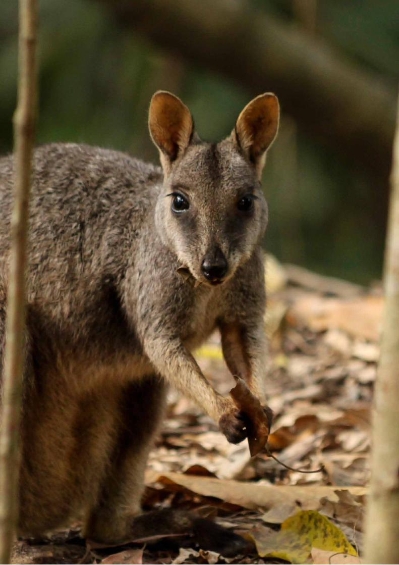

Ipswich City Council45 Roderick Street
PO Box 191, Ipswich QLD 4305, Australia
Phone (07) 3810 6666 Fax (07) 3810 6731