1735 ipswich portman 271005 - ipswich borough council | portman road urban design brief strategic...
TRANSCRIPT
FINAL REPORTOCTOBER 2005
IPSWICH PORTMAN ROAD URBAN DESIGN BRIEF
STRATEGIC URBAN DESIGN FRAMEWORK IPSWICH VILLAGE/CARDINAL PARK AREA

01 Introduction . . . . . . . . . . . . . . . . . . . . . . .5
02 Planning Policy Context . . . . . . . . . . . . .6
03 Area Appraisal . . . . . . . . . . . . . . . . . . . .10
04 Strategic Urban Design Framework . .29
05 Implementation . . . . . . . . . . . . . . . . . . .36
Appendices
A Urban Design Brief Portman Road
B Urban Design Brief West End Road Car Park
C Corridor Improvement Initiative
Project Director: Simon CarneUrban Initiatives 1 Fitzroy Square London W1T 5HEtel +44 (0)20 7380 4545fax +44 (0)20 7380 [email protected]
co
nte
nts
IPSWICH PORTMAN ROAD URBAN DESIGN BRIEF
STRATEGIC URBAN DESIGN FRAMEWORK IPSWICH VILLAGE/CARDINAL PARK AREA
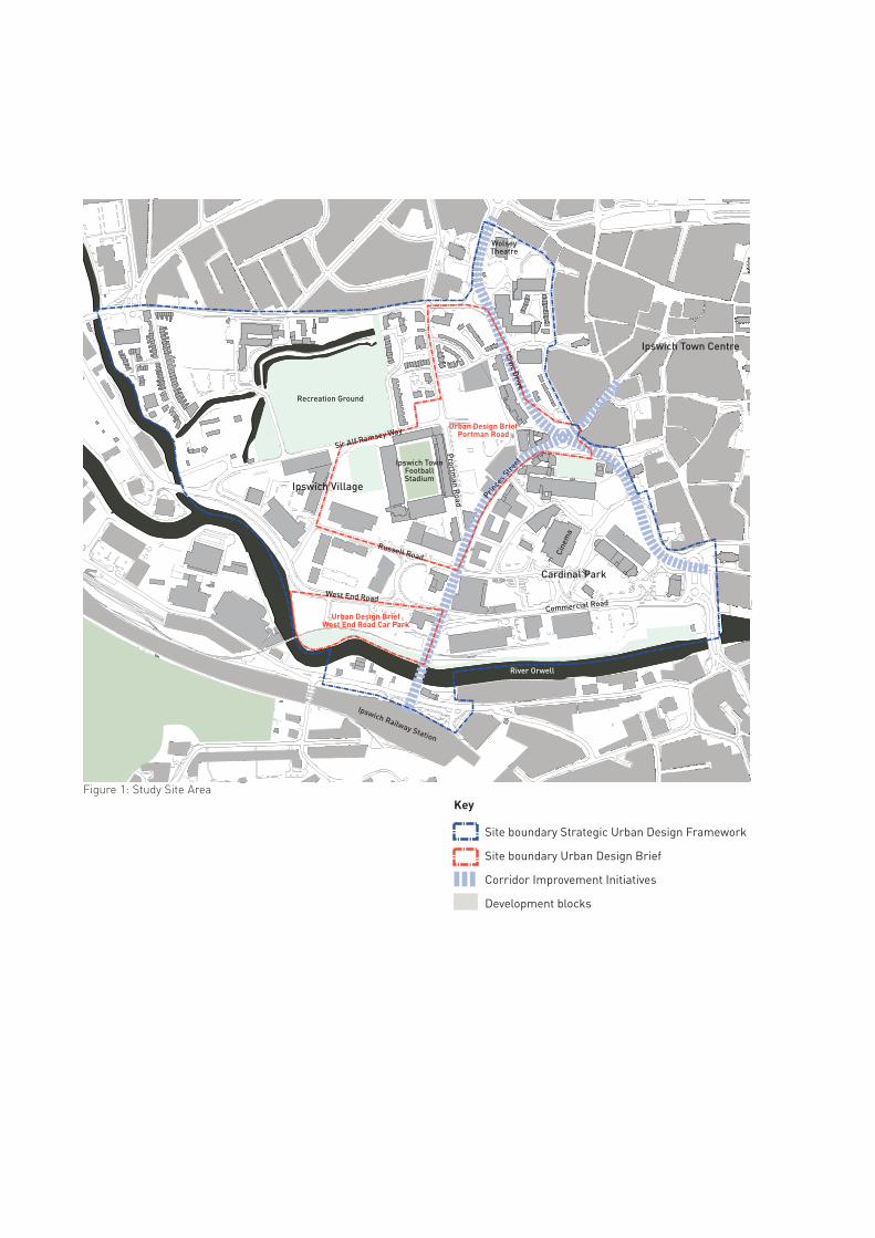
Ipswich Village
Cardinal Park
Ipswich Town Centre
Ipswich Railway Station
Ipswich TownFootballStadium
Prortm
an Road Prin
ces S
treet
Russell Road
Sir Alf Ramsey Way
Civic Drive
River Orwell
WolseyTheatre
Recreation Ground
West End RoadCommercial Road
Cine
ma
Urban Design BriefWest End Road Car Park
Urban Design BriefPortman Road
Figure 1: Study Site Area
Site boundary Strategic Urban Design Framework
Site boundary Urban Design Brief
Corridor Improvement Initiatives
Development blocks
Key
1 7 3 5 S T R A T E G I C U R B A N D E S I G N F R A M E W O R K I P S W I C H V I L L A G E / C A R D I N A L P A R K A R E A
01 INTRODUCTION
Ipswich is a place undergoing major changes. Whilst it has not suffered the loss of prestige that other
historic towns have suffered, it was nevertheless for much of the industrial revolution, a town that lost
rather than gained in significance, when set against the expansion of major cities in the north and
midlands. This is now changing and Ipswich is growing fast, not just around the attractive Waterfront area,
but also within the wider urban area.
The opportunity for this expansion however is only one part of the story. The other aspect of Ipswich as a
town is that there are large significant opportunities for the creation of a greatly enlarged urban centre
located between historic town centre and the railway station. This area known as Ipswich Village already
accommodates a number of important Ipswich institutions, most notably the Ipswich Town Football club.
In November 2004, Ipswich Borough Council (IBC) commissioned Urban Initiatives to prepare an urban
design brief for a number of sites surrounding Ipswich Town Football Club. Initial site analysis revealed the
significant development potential throughout the entire Ipswich Village and Cardinal Park district. Equally
the need for an overarching development framework was recognised, which would help the establishment
of a legible and integrated urban structure and give guidance on appropriate forms of development. Such a
document would form the baseline for the preparation of more detailed and site-specific urban design
briefs. This methodology was acknowledged by the IBC, and the brief was extended to cover the entire
Ipswich Village and Cardinal Park area.
The following document reflects this approach. It comprises four stand-alone documents that are brought
together within a single report.
Strategic Urban Design Framework (SUDF)
It comprises an outline of the planning policy context and a comprehensive analysis of the Ipswich Village
and Cardinal Park district, with particular focus on development potential, local assets, linkages and
qualities of the pedestrian network. This forms basis for a development vision, which identifies the key
elements of a future urban structure that would become the underlying framework for the successful
development of the area. Furthermore it outlines urban design principles to guide a coherent development
of the built form and help the establishment of an attractive and safe pedestrian environment.
Below this umbrella document the other studies are attached as Appendices. They include the following:
Appendix A: Urban Design Brief Portman Road Area
Within this document the recommendations of the SUDF are further developed into a site-specific urban
design brief. It lays out an urban structure with indication of streets blocks and development plots, and
makes recommendations on land use, development height and massing, configuration of frontages,
landscaping and public realm. Two development scenarios for a site east of Portman Road are developed,
one as a location for a large-scale entertainment or leisure venue, the other as finer grain mixed use
development.
Appendix B: Urban Design Brief West End Road Car Park
This document addresses a potential development site at the river that is owned by Ipswich Borough
Council. The Council plans to replace the current surface car park at the site with a multi-storey solution
and free up space for supplementary development. This document lays out a development structure, height
and massing of buildings and new public spaces. Further it includes an option appraisal of different car
park arrangements in terms of their capacity and impact on the urban environment.
Appendix C: Corridor Improvement Initiatives
This document was prepared to inform the preparation of Local Transport Plan II by Suffolk County Council.
It analyses the pedestrian environment in the study area and identifies two key pedestrian corridors that
require improvement. It assesses these corridors in terms of pedestrian safety, environmental quality,
legibility and directness of these routes, and makes suggestions for junction improvements, public realm
treatment and the creation of new public spaces.
5
6
In 2003 Ipswich Borough Council prepared an Area Action Plan (AAP) for the town, which extends over 280
hectares and includes the Town Centre, Ipswich Village, the Waterfront and Suffolk County Council and
College sites.
The AAP addresses land use, transport and design guidance for emerging developments on the Waterfront
together with a framework for the town that envisages future developments emerging from the Council's
Urban Renaissance objectives for the Town Centre. These are to:
1. Provide a framework for investment, which will create and sustain social and economic regeneration and
the integration of new and existing communities;
2. Promote redevelopment, which will preserve and enhance the character of the Waterfront area;
3. Integrate the Waterfront and town centre by reducing the detrimental impact of the Star Lane gyratories
and creating safe and convenient pedestrian and cycle routes; and
4. Integrate the Ipswich Village Quarter and the town centre by achieving attractive green routes linking
them and improving pedestrian and cycle connections.
The overarching aims of the AAP are to create direct and legible routes to connect the various Quarters
within the town centre, and to encourage development in a manner that is appropriate to the character and
predicted uses of the different Quarters.
Potential key projects included the development of bus interchange(s), new mixed use Quarters (eg. Ipswich
Villages and the Mint Quarter), the incorporation of an Education precinct and the development of better
cross town links to provide for the needs of pedestrians as well as vehicles.
In taking forward the aspirations of the AAP the following urban design qualities, essential to making
successful places, should be integral to the design of all new developments in the town. The following
qualities are set out in the recent DTLR / CABE Publication 'By Design':
02 PLANNING POLICY CONTEXT
• Character and distinctiveness: through the enhancement of the character of the area by
respecting its locally distinctive patterns of development, sense of history, culture and traditions;
• Continuity and Enclosure: through reinforcing the continuity of street and the enclosure of space
by development, which clearly defines private and public areas;
• Quality of the Public Realm: through the quality of the space between buildings by providing
spaces and routes that are safe, uncluttered, active and identifiable;
• Connectivity and Permeability: through high accessibility and local movement by making places
that connect with each other and are easy to move through;
• Legibility and Identity: through ease of understanding through development that provides a
system of recognizable routes, nodes and features to orientate users;
• Diversity and Choice: through a mix of compatible uses that work together to create vital and
viable places, and meet a wide range of local needs;
• Adaptability and Robustness: through development that can easily respond to changing social,
technological, economic and market conditions, and
• Integration and Efficiency: through sustainable development, which integrates land uses,
transport and the natural environment, promotes walkability and reduces the need to travel.
1 7 3 5 S T R A T E G I C U R B A N D E S I G N F R A M E W O R K I P S W I C H V I L L A G E / C A R D I N A L P A R K A R E A 7
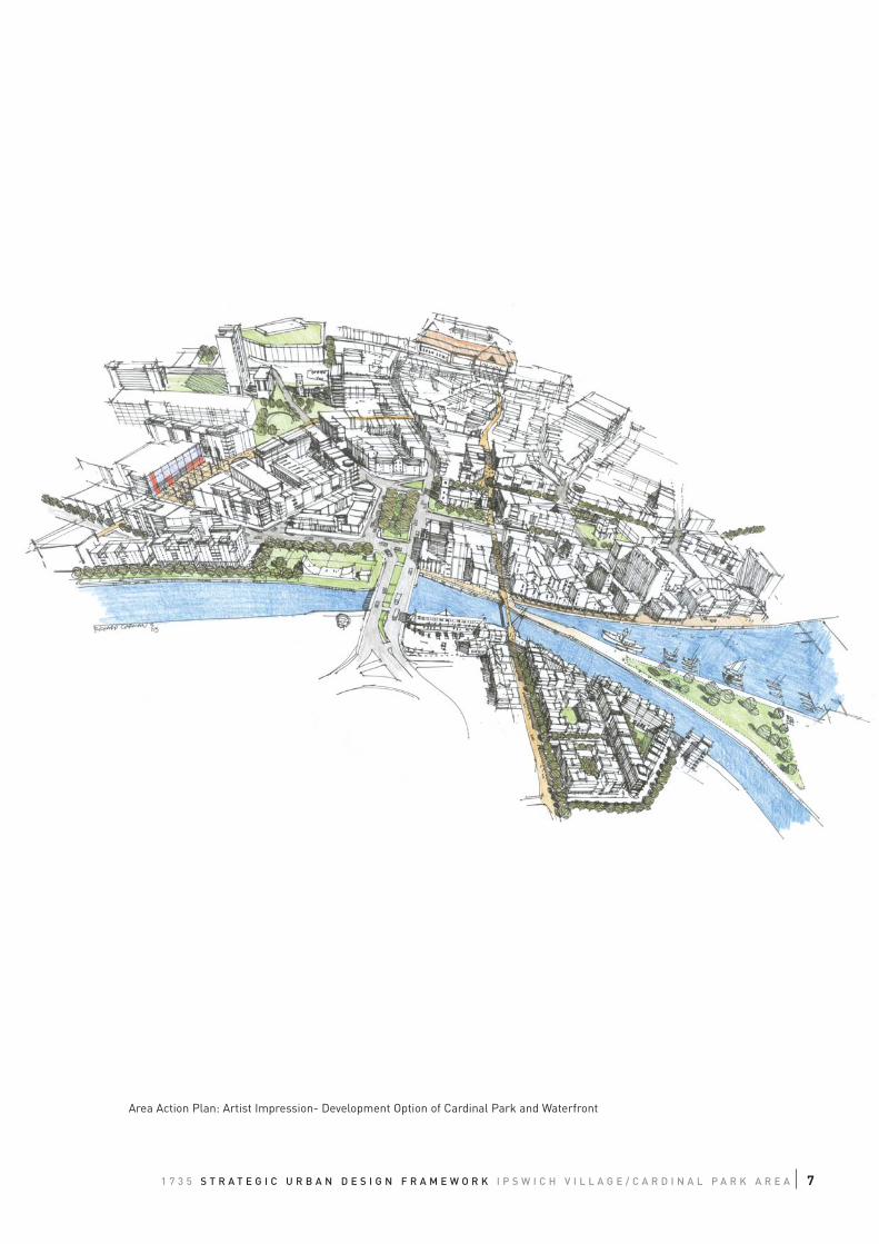
Area Action Plan: Artist Impression- Development Option of Cardinal Park and Waterfront
8
The translation of these qualities into the spatial structure and appropriate form of development for
particular development sites is expressed in this document in terms of:
• Urban structure;
• Urban grain;
• Density and mix of uses;
• Height and Massing;
• Façade and interface, and
• Landscape and public realm.
Ipswich Local Plan
The First Deposit Draft Local Plan provides a framework for investment in Ipswich Village with a
number of policies seeking to ensure that the area is easily accessible and develops in a sustainable,
mixed use way. It also seeks to do this by enabling a high quality environment for residential,
employment and leisure activities.
The Plan identifies that fundamental to achieving a sustainable urban renaissance is the creation of an
area that is vibrant at all times of the day. Crucial to achieving this is the establishment of a new
residential community that will grow from that which exists already. (See FDDLP Policy IV1).
The Village is fast becoming the heart of an innovative public service cluster in Ipswich with the
relocation of Suffolk County Council and the Crown Court to sites in Russell Road. As a consequence,
employment opportunities within the area are developing quickly. It is vital to keep this development
growing and the provision of mixed use allocations in the FDDLP at identified Village sites will continue
to encourage and enable this growth.
Other public sector organizations such as Ipswich Borough Council (IBC) are also proposing to move
into the area.
The Village will continue to have a major role to play in providing leisure activities and the FDDLP
includes policies (IV2 and IV3) to facilitate this development in the wider context of Ipswich as well as
the Village.
THE FDDLP provides the policy framework to enable this key part of Ipswich to regenerate, develop and
become a vibrant new quarter in the centre of Ipswich.
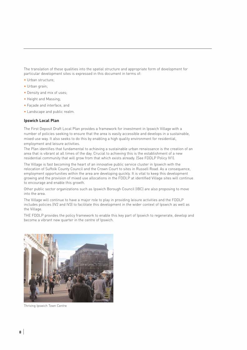
Thriving Ipswich Town Centre
1 7 3 5 S T R A T E G I C U R B A N D E S I G N F R A M E W O R K I P S W I C H V I L L A G E / C A R D I N A L P A R K A R E A 9
Ipswich Area Action Plan
Ipswich Village
Ipswich 'Village' is centered on Ipswich Town Football Club (ITFC) and its stadium at Portman Road.
The Borough Council seeks regeneration through mixed use development and improved links to, and
integration with, the town centre, the waterfront, the education quarter and the Railway Station. The
area, whose origins are fairly recent (the area being undeveloped marshes until the 20th century),
epitomises the changing character of Ipswich and recent developments confirm the potential for the
creation of a truly mixed use, sustainable urban area.
Cardinal Park Area
The Cardinal Park Area is at present poorly connected to other parts of the town especially for
pedestrian and cyclists and those using public transport, its built form and character have little or no
respect for the vernacular style. It therefore does not at present seem to be part of the town centre.
The Ipswich Area Action plan stresses the need to integrate this area into the urban structure of the
town centre, into the Ipswich Village, the Cardinal Park area and to create new pedestrian and cycle
routes and thus opening the peripheral areas up to the town centre.
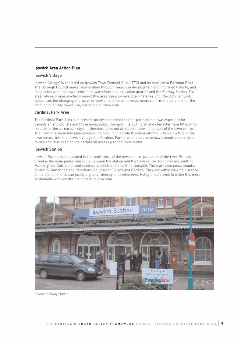
Ipswich Station
Ipswich Rail station is located to the south west of the town centre, just south of the river. Princes
Street is the main pedestrian route between the station and the town centre. Rail links are south to
Manningtree, Colchester and stations to London and north to Norwich. There are also cross-country
routes to Cambridge and Peterborough. Ipswich Village and Cardinal Park are within walking distance
of the station and so can justify a greater density of development. Policy should seek to make this more
sustainable with constraints in parking provision.
Ipswich Railway Station
10
03 AREA APPRAISAL
3.1 LOCATION
The Ipswich Village and Cardinal Park areas are located south west of Ipswich Town Centre. The areas are
bounded to the north by Handford Road, to the east by the inner ring road comprising Civic Drive and Franciscan
Way, and to the south and west by the river Orwell.
3.2 URBAN DESIGN ANALYSIS
The area is appraised in urban design terms using aspects of development form as described in “by design:
urban design in the planning system: towards better practice”.
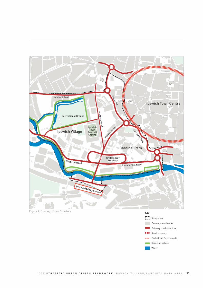
3.2.1 Urban Structure
The urban structure is the framework of routes and spaces that link the area with the surrounding context and
forms the backbone of an area in terms of access and movement. The layout has a considerable impact on
legibility and the character of an area.
In Ipswich Village/ Cardinal Park the urban structure is poor. It fails to link the different elements and to integrate
the area with the surrounding context. In particular the configuration of Civic Drive/ Franciscan Way corridor
creates a barrier between the town centre and the study area with inappropriate pedestrian links including
unpleasant subways.
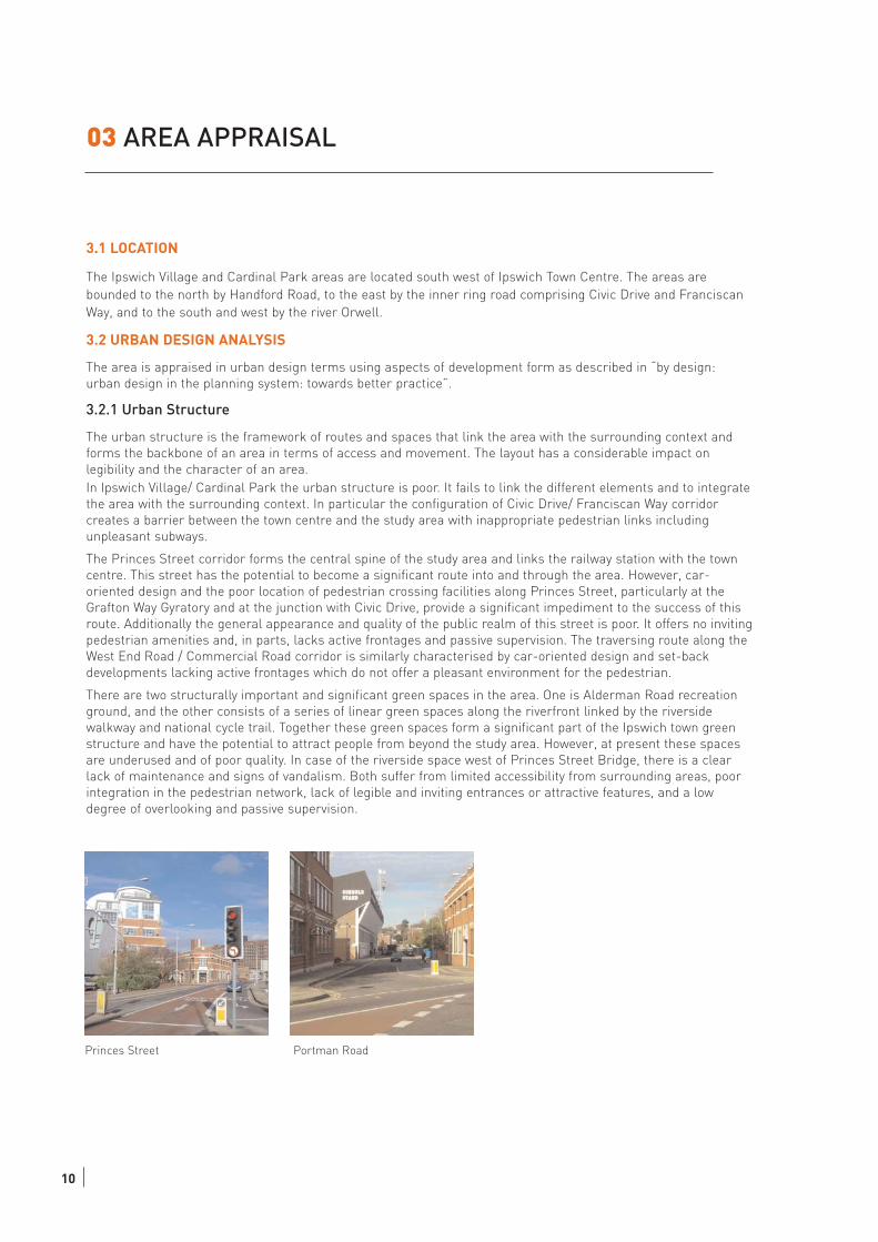
The Princes Street corridor forms the central spine of the study area and links the railway station with the town
centre. This street has the potential to become a significant route into and through the area. However, car-
oriented design and the poor location of pedestrian crossing facilities along Princes Street, particularly at the
Grafton Way Gyratory and at the junction with Civic Drive, provide a significant impediment to the success of this
route. Additionally the general appearance and quality of the public realm of this street is poor. It offers no inviting
pedestrian amenities and, in parts, lacks active frontages and passive supervision. The traversing route along the
West End Road / Commercial Road corridor is similarly characterised by car-oriented design and set-back
developments lacking active frontages which do not offer a pleasant environment for the pedestrian.
There are two structurally important and significant green spaces in the area. One is Alderman Road recreation
ground, and the other consists of a series of linear green spaces along the riverfront linked by the riverside
walkway and national cycle trail. Together these green spaces form a significant part of the Ipswich town green
structure and have the potential to attract people from beyond the study area. However, at present these spaces
are underused and of poor quality. In case of the riverside space west of Princes Street Bridge, there is a clear
lack of maintenance and signs of vandalism. Both suffer from limited accessibility from surrounding areas, poor
integration in the pedestrian network, lack of legible and inviting entrances or attractive features, and a low
degree of overlooking and passive supervision.
Princes Street Portman Road
1 7 3 5 S T R A T E G I C U R B A N D E S I G N F R A M E W O R K I P S W I C H V I L L A G E / C A R D I N A L P A R K A R E A 11
Ipswich Town Centre
Ipswich Village
Cardinal Park
Civic Drive
Franciscan Way
Handford Road
Grafton WayGyratory
Commercial RoadWest End Road
Recreational Ground
IpswichTown
FootballGround
Prince
s Stre
et
Portm
an Road
Ipswich Railway Station
Figure 2: Existing Urban Structure
Study area
Development blocks
Primary road structure
Road bus only
Pedestrian / cycle route
Green structure
Water
Key
12
3.2.2 Urban Grain
Beside the key elements of the urban structure the layout of an area is determined by the pattern and
arrangement of streets, blocks and plots. The concept of “urban grain” gives an indication of the degree to which
an area's pattern of blocks and plots subdivision is respectively small and frequent (fine grain), or large and
infrequent (coarse grain). The urban grain significantly impacts on the permeability of an area and the choices to
move around it. It similarly has an influence on the extent of adaptability, diversity and inclusiveness an area can
offer as a base for development.
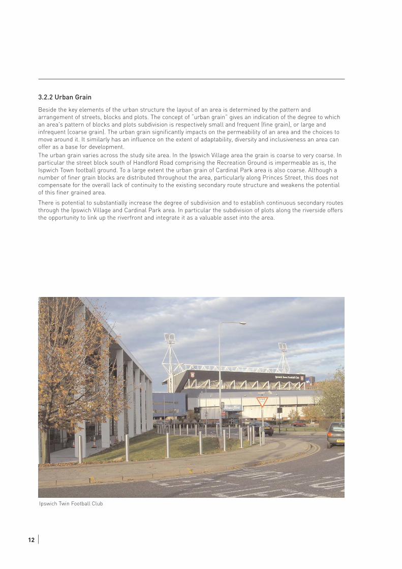
The urban grain varies across the study site area. In the Ipswich Village area the grain is coarse to very coarse. In
particular the street block south of Handford Road comprising the Recreation Ground is impermeable as is, the
Ispwich Town football ground. To a large extent the urban grain of Cardinal Park area is also coarse. Although a
number of finer grain blocks are distributed throughout the area, particularly along Princes Street, this does not
compensate for the overall lack of continuity to the existing secondary route structure and weakens the potential
of this finer grained area.
There is potential to substantially increase the degree of subdivision and to establish continuous secondary routes
through the Ipswich Village and Cardinal Park area. In particular the subdivision of plots along the riverside offers
the opportunity to link up the riverfront and integrate it as a valuable asset into the area.
Ipswich Twin Football Club
Ipswich Town Centre
Handford Road
Grafton WayGyratory
Commercial RoadWest End Road
Ipswich Railway Station
Prince
s Stre
et
Portm
an Road
Ipswich Village
Cardinal Park
Franciscan Way
Civic Drive
Figure 3: Urban Grain
Study area
Development blocks
Primary road structure
Secondary road structure
Bus only
Pedestrian / Cycle Route
Urban Grain
Very coarse urban grain
Coarse urban grain
Fine urban grain
Key
131 7 3 5 S T R A T E G I C U R B A N D E S I G N F R A M E W O R K I P S W I C H V I L L A G E / C A R D I N A L P A R K A R E A
14
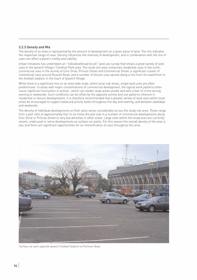
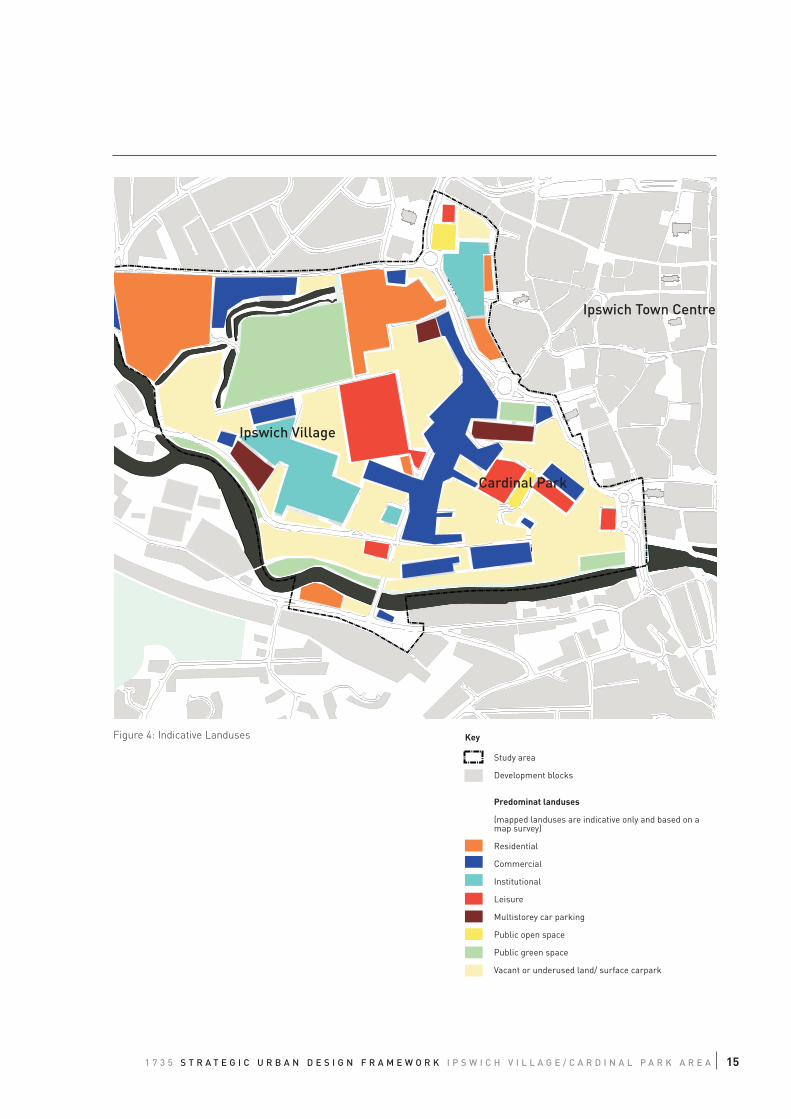
3.2.3 Density and MixThe density of an area is represented by the amount of development on a given piece of land. The mix indicates
the respective range of uses. Density influences the intensity of development, and in combination with the mix of
uses can affect a place's vitality and viability.
Urban Initiatives has undertaken an “indicative/broad brush” land use survey that shows a great variety of land
uses in the Ipswich Village / Cardinal Park area. The study site area comprises residential uses in the north,
commercial uses in the vicinity of Civic Drive, Princes Street and Commercial Street, a significant cluster of
institutional uses around Russell Road, and a number of leisure uses spread along a line from the waterfront to
the football stadium in the heart of Ipswich Village.
While there is a significant mix on an area wide scale, within local sub-areas, single land uses are often
predominant. In areas with major concentrations of commercial development, the typical work patterns often
cause significant fluctuation in activity , which can render large areas unsafe and with a fear of crime during
evening or weekends. Such conditions can be offset by the opposite activity and use patterns inherent in
residential or leisure developments. It is therefore recommended that a greater variety of land uses within local
areas be encouraged to support balanced activity levels throughout the day and evening, and between weekdays
and weekends.
The density of individual developments on their plots varies considerably across the study site area. These range
from a plot ratio of approximately four to six times the plot size in a number of commercial developments along
Civic Drive or Princes Street to very low densities in other areas. Large sites within the study area are currently
vacant, underused or serve developments as surface car parks. For this reason the overall density of the area is
low, and there are significant opportunities for an intensification of uses throughout the area.
Surface car park opposite Ipswich Football Stadium at Portman Road
Ipswich Town Centre
Handford Road
Commercial RoadWest End Road
Portm
an Road
Civic Drive
Ipswich Village
Cardinal Park
Figure 4: Indicative Landuses
Study area
Development blocks
Predominat landuses
(mapped landuses are indicative only and based on amap survey)
Residential
Commercial
Institutional
Leisure
Multistorey car parking
Public open space
Public green space
Vacant or underused land/ surface carpark
Key
151 7 3 5 S T R A T E G I C U R B A N D E S I G N F R A M E W O R K I P S W I C H V I L L A G E / C A R D I N A L P A R K A R E A
16
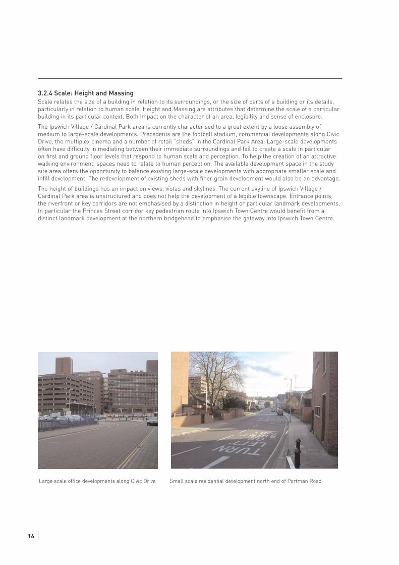
3.2.4 Scale: Height and MassingScale relates the size of a building in relation to its surroundings, or the size of parts of a building or its details,
particularly in relation to human scale. Height and Massing are attributes that determine the scale of a particular
building in its particular context. Both impact on the character of an area, legibility and sense of enclosure.
The Ipswich Village / Cardinal Park area is currently characterised to a great extent by a loose assembly of
medium to large-scale developments. Precedents are the football stadium, commercial developments along Civic
Drive, the multiplex cinema and a number of retail “sheds” in the Cardinal Park Area. Large-scale developments
often have difficulty in mediating between their immediate surroundings and fail to create a scale in particular
on first and ground floor levels that respond to human scale and perception. To help the creation of an attractive
walking environment, spaces need to relate to human perception. The available development space in the study
site area offers the opportunity to balance existing large-scale developments with appropriate smaller scale and
infill development. The redevelopment of existing sheds with finer grain development would also be an advantage.
The height of buildings has an impact on views, vistas and skylines. The current skyline of Ipswich Village /
Cardinal Park area is unstructured and does not help the development of a legible townscape. Entrance points,
the riverfront or key corridors are not emphasised by a distinction in height or particular landmark developments.
In particular the Princes Street corridor key pedestrian route into Ipswich Town Centre would benefit from a
distinct landmark development at the northern bridgehead to emphasise the gateway into Ipswich Town Centre.
Large scale office developments along Civic Drive Small scale residential development north end of Portman Road
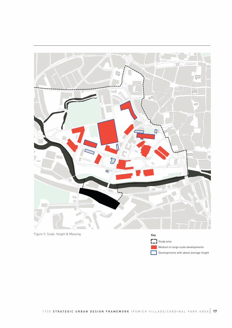
Figure 5: Scale: Height & Massing
Study area
Medium to large scale developments
Developments with above average height
Key
171 7 3 5 S T R A T E G I C U R B A N D E S I G N F R A M E W O R K I P S W I C H V I L L A G E / C A R D I N A L P A R K A R E A
18
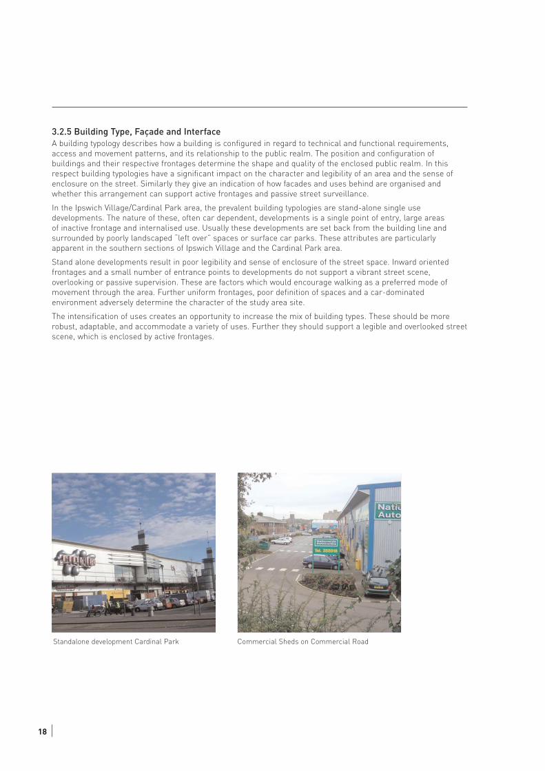
3.2.5 Building Type, Façade and InterfaceA building typology describes how a building is configured in regard to technical and functional requirements,
access and movement patterns, and its relationship to the public realm. The position and configuration of
buildings and their respective frontages determine the shape and quality of the enclosed public realm. In this
respect building typologies have a significant impact on the character and legibility of an area and the sense of
enclosure on the street. Similarly they give an indication of how facades and uses behind are organised and
whether this arrangement can support active frontages and passive street surveillance.
In the Ipswich Village/Cardinal Park area, the prevalent building typologies are stand-alone single use
developments. The nature of these, often car dependent, developments is a single point of entry, large areas
of inactive frontage and internalised use. Usually these developments are set back from the building line and
surrounded by poorly landscaped “left over” spaces or surface car parks. These attributes are particularly
apparent in the southern sections of Ipswich Village and the Cardinal Park area.
Stand alone developments result in poor legibility and sense of enclosure of the street space. Inward oriented
frontages and a small number of entrance points to developments do not support a vibrant street scene,
overlooking or passive supervision. These are factors which would encourage walking as a preferred mode of
movement through the area. Further uniform frontages, poor definition of spaces and a car-dominated
environment adversely determine the character of the study area site.
The intensification of uses creates an opportunity to increase the mix of building types. These should be more
robust, adaptable, and accommodate a variety of uses. Further they should support a legible and overlooked street
scene, which is enclosed by active frontages.
Standalone development Cardinal Park Commercial Sheds on Commercial Road
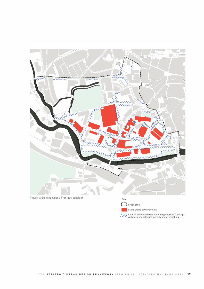
Figure 6: Building types / Frontage condition
Study area
Stand alone developments
Lack of developed frontage / inappropriate frontagewith lack of enclosure, activity and overlooking
Key
191 7 3 5 S T R A T E G I C U R B A N D E S I G N F R A M E W O R K I P S W I C H V I L L A G E / C A R D I N A L P A R K A R E A

20
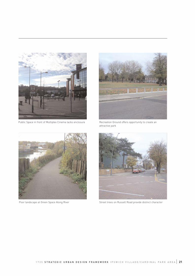
3.2.6 Streetscape, Landscape
The appearance of the streetscape and landscape in an area together with the amenities they provide are
significant factors that determine the perception, attractiveness and character of an area. High quality public
realm and landscape design can make a significant contribution towards the success of a place and help
determine whether it is inviting for people and attractive for businesses to invest in.
The general appearance of the streetscape in Ipswich Village and Cardinal Park is poor. Piecemeal and
subsequent changes to the layout have resulted in a cluttered and inconsistent public realm with a number
of different design standards, elements and materials being used. The car oriented street space treats the
pedestrian as inferior, which is further reflected in poor quality pedestrian spaces and a lack of legible and
direct pedestrian routes.
This study recognises three public spaces within the study area. These all offer considerable potential for
improvement. The space in front of the multiplex cinema lacks a sense of enclosure and intimacy but has the
potential to more fully exploit its significance; the Wolsey Theatre public space is adversely affected by car
parking below , various changes of level, and does not relate to pedestrian route desire lines. It also fails to
attract people. The entrance space to the railway station does not create an attractive gateway or efficient
pedestrian interchange with space for all the essential functions of a railway station, nor does it adequately
reflect the civic aspirations of the people of Ipswich.
Given the size and importance of the study area in the context of Ipswich Town Centre, there is a considerable
lack of quality public spaces. There is an opportunity with the regeneration of Ipswich Village and Cardinal Park
to create a number of new public spaces, which can act as focal points, offer amenities and recreational qualities
for people as well as establish a legible townscape.
The landscape setting is also poor. Some effort has been made in creating a waterfront path with explanatory and
interpretation boards as well as a public art feature. However, the site is rarely used, it lacks maintenance and
has been vandalised. The Recreation Ground opposite the football stadium has recently been improved with the
installation of a children play area. However, to become an attractive destination for people the connectivity to
surrounding areas has to be improved, in particular towards the north. Similarly the landscape design should
better explore the existing assets such as the watercourses to embrace the natural environment, and create a
variety of attractive and interesting amenities.
Russell Road features an impressive collection of mature street trees, which positively determine character and
sense of enclosure in this street. There are also significant opportunities to extend the use of street trees across
the wider study site area to support a coherent public realm treatment.
Public Space in front of Multiplex Cinema lacks enclosure Recreation Ground offers opportunity to create an
attractive park
Poor landscape at Green Space Along River Street trees on Russell Road provide distinct character
211 7 3 5 S T R A T E G I C U R B A N D E S I G N F R A M E W O R K I P S W I C H V I L L A G E / C A R D I N A L P A R K A R E A
22
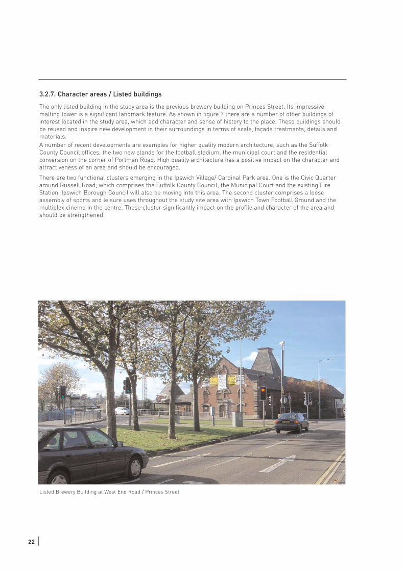
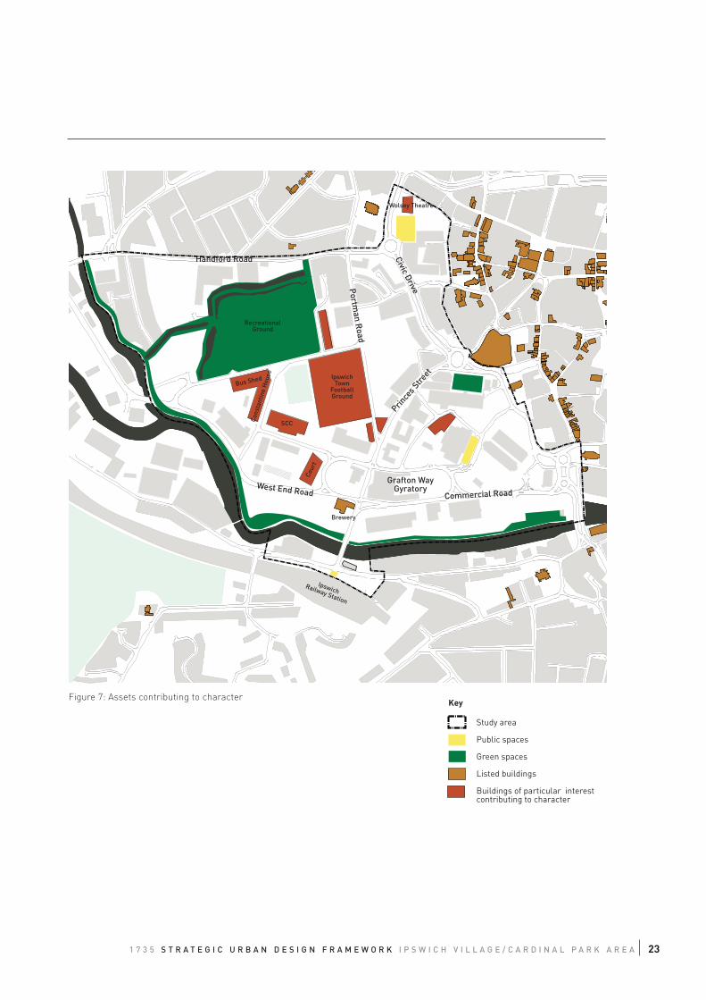
3.2.7. Character areas / Listed buildings
The only listed building in the study area is the previous brewery building on Princes Street. Its impressive
malting tower is a significant landmark feature. As shown in figure 7 there are a number of other buildings of
interest located in the study area, which add character and sense of history to the place. These buildings should
be reused and inspire new development in their surroundings in terms of scale, façade treatments, details and
materials.
A number of recent developments are examples for higher quality modern architecture, such as the Suffolk
County Council offices, the two new stands for the football stadium, the municipal court and the residential
conversion on the corner of Portman Road. High quality architecture has a positive impact on the character and
attractiveness of an area and should be encouraged.
There are two functional clusters emerging in the Ipswich Village/ Cardinal Park area. One is the Civic Quarter
around Russell Road, which comprises the Suffolk County Council, the Municipal Court and the existing Fire
Station. Ipswich Borough Council will also be moving into this area. The second cluster comprises a loose
assembly of sports and leisure uses throughout the study site area with Ipswich Town Football Ground and the
multiplex cinema in the centre. These cluster significantly impact on the profile and character of the area and
should be strengthened.
Listed Brewery Building at West End Road / Princes Street
Civic Drive
Handford Road
Grafton WayGyratory
Commercial RoadWest End Road
Prince
s Stre
et
Portm
an Road
IpswichTown
FootballGround
RecreationalGround
SCC
Bus Shed
Cons
tant
ine
Hou
se
Cour
t
Wolsey Theatre
Brewery
IpswichRailway Station
Figure 7: Assets contributing to character
Study area
Public spaces
Green spaces
Listed buildings
Buildings of particular interestcontributing to character
Key
231 7 3 5 S T R A T E G I C U R B A N D E S I G N F R A M E W O R K I P S W I C H V I L L A G E / C A R D I N A L P A R K A R E A
24
3.3 ACCESS & MOVEMENT
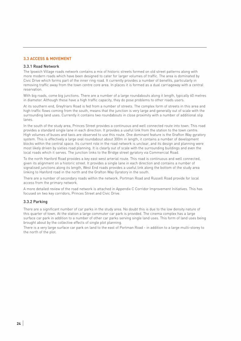
3.3.1 Road NetworkThe Ipswich Village roads network contains a mix of historic streets formed on old street patterns along with
more modern roads which have been designed to cater for larger volumes of traffic. The area is dominated by
Civic Drive which forms part of the inner ring road. It currently provides a number of benefits, particularly in
removing traffic away from the town centre core area. In places it is formed as a dual carriageway with a central
reservation.
With big roads, come big junctions. There are a number of a large roundabouts along it length, typically 60 metres
in diameter. Although these have a high traffic capacity, they do pose problems to other roads users.
At its southern end, Greyfriars Road is fed from a number of streets. The complex form of streets in this area and
high traffic flows coming from the south, means that the junction is very large and generally out of scale with the
surrounding land uses. Currently it contains two roundabouts in close proximity with a number of additional slip
lanes.
In the south of the study area, Princes Street provides a continuous and well connected route into town. This road
provides a standard single lane in each direction. It provides a useful link from the station to the town centre.
High volumes of buses and taxis are observed to use this route. One dominant feature is the Grafton Way gyratory
system. This is effectively a large oval roundabout about 300m in length, it contains a number of development
blocks within the central space. Its current role in the road network is unclear, and its design and planning were
most likely driven by sixties road planning. It is clearly out of scale with the surrounding buildings and even the
local roads which it serves. The junction links to the Bridge street gyratory via Commercial Road.
To the north Hanford Road provides a key east west arterial route. This road is continuous and well connected,
given its alignment on a historic street. It provides a single lane in each direction and contains a number of
signalised junctions along its length, West End roads provides a useful link along the bottom of the study area
linking to Hanford road in the north and the Grafton Way Gyratory in the south.
There are a number of secondary roads within the network. Portman Road and Russell Road provide for local
access from the primary network.
A more detailed review of the road network is attached in Appendix C Corridor Improvement Initiatives. This has
focused on two key corridors, Princes Street and Civic Drive.
3.3.2 Parking
There are a significant number of car parks in the study area. No doubt this is due to the low density nature of
this quarter of town. At the station a large commuter car park is provided. The cinema complex has a large
surface car park in addition to a number of other car parks serving single land uses. This form of land uses being
brought about by the collective effects of single plot planning.
There is a very large surface car park on land to the east of Portman Road - in addition to a large multi-storey to
the north of the plot.
P
P
P
P
P
251 7 3 5 S T R A T E G I C U R B A N D E S I G N F R A M E W O R K I P S W I C H V I L L A G E / C A R D I N A L P A R K A R E A
Figure 8: Road network / parking
P
Study area
Primary road network
Secondary roads
Access roads
Bus-only
Surface car park
Multistorey car park
Key
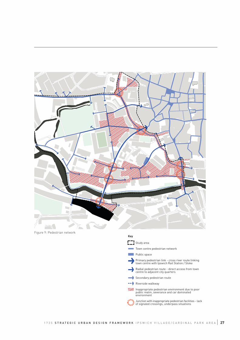
3.3.3 Pedestrian Network
The poor movement of people in the area is one of the biggest issues facing the area. Analysis of the
pedestrian network suggests that the actual network of streets is reasonable, although some of the larger
blocks do mean pedestrian trips are convoluted. Clearly the area would benefit from a reduced grain size,
which would made pedestrian trips around the network more direct.
The key problem with pedestrian movement is the type of facilities on offer. Key roads such as Civic Drive
act as significant barriers to movement - Civic Drive should unite the area. It cuts Ipswich Village off from
the main town centre area. Along its whole length, the environment is car dominated. Pedestrian
crossings are typically provided for by subways, which increase walk time and reduce legibility. There is
now a clear national view that subways should basically be removed from our towns and cities.
The route from the Station to the town centre is also seen as a key problem, mainly due to the detail of
junctions along the route. When leaving the station, pedestrians need to navigate across the station
intercheange and then through a signal junction. Once over the bridge, there a number of crossing
problems through the traffic signal junctions around Grafton Way. A number of these junctions do not have
crossings. The next major barrier is the junction with Civic Drive. This large roundabout contains no
surface crossings. All pedestrians are required to use a convoluted subway system with little legibility.
A further problem area for the pedestrian is the wedge of land fronting the river running from the Star
Lane gyratory to the Civic quarter. This contains a mix of car park dominated environments and the
Grafton Way gyratory. When taken together, these provide the worst type of environment for pedestrians,
with poor routes through car parks.
The Bridge Street junction also suffered from having a poor pedestrian environment. This junction lies on
an important link from St Peter’s Street through into the waterfront area.
3.3.4 Public Transport Network
Ipswich station provides goods links to London, Norwich and other more local destinations. A multimodal
interchange is provided outside the station forecourt, providing facilities for buses, taxis, short term
parking and 'kiss and ride'. There are parking facilities for various modes including car, cycle and
motorcycles.
Ipswich is well served by a network of local and regional buses. There are two main bus stations, Tower
Ramparts and Old Cattlemarket. To optimise bus movement there is a central bus loop which wraps
around the town core operating in an anticlockwise direction. One current problem is that this loop does
not extend to the station. In practice this means only limited buses travel past the station. This reduces the
opportunity for rail/bus interchange.
1 7 3 5 S T R A T E G I C U R B A N D E S I G N F R A M E W O R K I P S W I C H V I L L A G E / C A R D I N A L P A R K A R E A 27
Figure 9: Pedestrian network
Study area
Town centre pedestrian network
Public space
Primary pedestrian link - cross river route linkingtown centre with Ipswich Rail Station / Stoke
Radial pedestrian route - direct access from towncentre to adjacent city quarters
Secondary pedestrian route
Riverside walkway
Inappropriate pedestrian environment due to poorpublic realm, severance and car dominatedenvironment
Junction with inappropriate pedestrian facilities - lackof signaled crossings, underpass situations
Key

28
1 7 3 5 S T R A T E G I C U R B A N D E S I G N F R A M E W O R K I P S W I C H V I L L A G E / C A R D I N A L P A R K A R E A 29
04 STRATEGIC URBAN DESIGN FRAMEWORK
4.1 THE VISION
Based on the preceding Urban Design Analysis Urban Initiatives formulated a development vision, which
embraces the aspirations of the Ipswich Local Plan (Deposit Draft) and the IP1 Area Action Plan. The area has
the potential to become a new destination within Ipswich incorporating the highest quality urban design, making
the most of the existing assets and developing on the back of emerging character zones. In this way it can
become a more lively, successful and attractive mixed use district, which activates the riverside and benefits from
its location between Ipswich Town Centre and the Railway station.
There are a number of structural elements that are key to building the vision for Ipswich Village / Cardinal Park
area. These are outlined below:
Riverfront and watercourse
Making the most of the existing environmental assets. Developing a continuous green park at the edge of Ipswich
Village and Cardinal Park to become an attractive route and recreational amenity for people. Exploring the
potential for high quality residential and mixed use developments overlooking the river.
Recreation Ground
Developing this green space into an inviting and attractive park, which has the potential to attract people from
surrounding districts. Accessibility needs to be improved and the landscape design should offer a greater variety
of amenities and attractions. For the park to be established as a destination, it would help to position it on the
mind map of the town by giving it a distinct name. The creation of a legible pedestrian route or “Park Way” from
Sir Alf Ramsey Way to Princes Street in the Town Centre should help to raise awareness and improve access to
this natural asset.
Civic Quarter
The emerging concentration of civic and institutional uses in the study area offers potential to develop a character
area with a distinct identity. Following the precedents of the SCC development and the Court, the new
developments should be of an outstanding architectural and urban design quality and aim to create a place
inspiring a sense of civic pride. Russell Road should be established as a legible backbone of the Civic Quarter
with new development creating appropriate frontage conditions towards this street. The Civic Quarter needs to be
better integrated into the surrounding area with an attractive pedestrian link into the town centre, the 'civic
quarter link', and permeability to neighbouring areas and the riverfront.
Developments overlooking
River
Attractive green strip along
this edge
Outstanding architecture for
Civic Uses
Park as local amenity of
pedestrian destination
30
Ipswich Town Centre
Park
Civic Quarter
R i v e r f r o n t
Waterfro
Ipswich Railway Station
P r i n c e s St r e e t
L e i s u r e Sp i n e
C i v i c Qu a r t e r Li n k
P a r k W a y
Sports and Leisure Quarter
Figure 10: Concept Vision
Study area
Structural green elements
Existing sport, leisure and entertainment use
Opportunity for future sport, leisure and entertainmuse
Existing/proposed institutional use
Key pedestrian corridors / thematic links
Secondary pedestrian links
Potential for new central node at intersection ofpedestrian corridors
Key
1 7 3 5 S T R A T E G I C U R B A N D E S I G N F R A M E W O R K I P S W I C H V I L L A G E / C A R D I N A L P A R K A R E A 31
Sports and Leisure Quarter
The Ipswich Football Stadium, the Multiplex cinema and a number of smaller leisure venues currently form the
core of the emerging Sports and Leisure Quarter. The distinct character of this area could be enhanced by
intensifying the sports and leisure uses and creating better linkages between single venues. The opportunity to
establish a 'leisure spine' should be explored, which would link the education quarter via the waterfront with the
leisure quarter and would establish a safe and attractive route particular for pedestrian and bicyclists.
Princes Street
This corridor links Ipswich Railway Station with Ipswich Town Centre and has the potential to become a primary
access route into and through the study site area particularly for pedestrians, cyclists and public transport.
Princes Street needs to be enhanced to create a more pedestrian friendly environment, and junctions along the
route require improvement to allow for at-grade and safe pedestrian crossings. The intensification of uses along
the corridor needs to provide appropriate frontages to support a vibrant and vital street scene. A new public space
is proposed at the intersection with the 'leisure spine' and the 'civic quarter link' to establish a new node and
heart of the Ipswich Village/Cardinal Park area.
New Public SpacesThere is an opportunity to develop a network of new public spaces at the intersection of the proposed pedestrian
routes in the area. These should become local centres and develop as places with strong and distinctive
character. Surrounding developments shall: be of high quality architecture; make use of this prominent location;
and develop an active and supporting relationship with this public space, particularly in terms of land uses, height
and frontage condition. At each space a new landmark development would foster the creation of a unique
character for the space.
Secondary Links
For successful regeneration into a vibrant and vital mixed use district the walkability within and into the area
needs to be improved. This requires the establishment of a finer grain urban structure where permeability is low.
To achieve better connectivity pedestrian routes need to be continuous and direct, and offer appropriate
pedestrian facilities. In particular the barrier of the Civic Drive/Franciscan Way corridor needs to be broken down
by creating links that are pleasant and safe and do not require the use of an underpass.
Re-locate space extensive uses
During the gradual transformation of the area some of the space extensive and car dependent commercial land
uses should be encouraged to move to more appropriate locations within Ipswich, to open up development
potential and allow for higher value, higher quality residential and commercial developments.
New public space as local hubNew public space as local hub Leisure use integrated into Urban Fabric
32
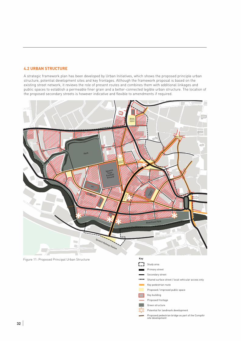
4.2 URBAN STRUCTURE
A strategic framework plan has been developed by Urban Initiatives, which shows the proposed principle urban
structure, potential development sites and key frontages. Although the framework proposal is based on the
existing street network, it reviews the role of present routes and combines them with additional linkages and
public spaces to establish a permeable finer grain and a better-connected legible urban structure. The location of
the proposed secondary streets is however indicative and flexible to amendments if required.
IpswichTown
Football
Ground
Park
‘LeisureSquare’
SCC
IBC
Cour
t Loca
l Hub
Brewery
Riverfront Park
Mul
tiple
xCi
nem
a
Ipswich Railway Station
WolseyTheatreSquare
Butter MarketSquare
Figure 11: Proposed Principal Urban Structure
Study area
Primary street
Secondary street
Shared surface street / local vehicular access only
Key pedestrian route
Proposed / improved public space
Key building
Proposed frontage
Green structure
Potential for landmark development
Proposed pedestrian bridge as part of the CompAirsite development
Key
4.3 OVERARCHING URBAN DESIGN PRINCIPLES
In order to achieve a coherent development throughout the Ipswich Village and Cardinal Park a number of
overarching principles of good urban design need to be applied. The following principles should set a framework
for development, which can be used to communicate the development vision and guide the evaluation of
development proposals.
Urban Grain
The urban grain relates to the morphological pattern of an area and indicates the degree to which an area's
pattern of blocks and plot division is respectively small and frequent. In the Ipswich Village/Cardinal Park area, it
is proposed to introduce a finer urban grain. This will improve connectivity and permeability, and assist
independent and staged development.
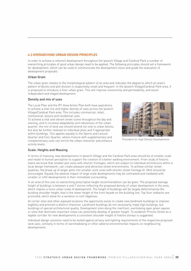
Density and mix of uses
The Local Plan and the IP1 Area Action Plan both have aspirations
to achieve a vital mix and higher density of uses across the Ipswich
Village/Cardinal Park area. This includes commercial, retail,
institutional, leisure and residential uses.
To achieve a vital and vibrant street scene throughout the day and
evening, and to increase adaptability and robustness of the urban
quarter, the mix of land use should extend not only to urban blocks,
but also be further realised on individual plots and if appropriate
within buildings. This applies equally to the Sports and Leisure
Quarter and Civic Quarter, where mixture with supplementary and
complementary uses can enrich the urban character and enhance
activity levels.
Scale: Heights and Massing
In terms of massing, new developments in Ipswich Village and the Cardinal Park area should be of smaller scale
and relate to human perception to support the creation of a better walking environment. From study of historic
towns we know that smaller plot sizes with shorter frontages, which are subject to individual architecture within a
local design framework, can create pleasant and attractive street environments. To achieve similar street
qualities, the break up of larger plots into smaller units sizes with shorter street frontage (6-18m) should be
encouraged. Equally the adverse impact of large scale developments may be contrasted and mediated with
smaller or infill developments in their immediate surrounding.
In an area of this size no overarching prescriptive height recommendation can be given. The proposed average
height of buildings is between 4 and 7 stories reflecting the proposed density of urban development in the area,
which implies a more urban scale of development. The height of buildings will be largely determined by the
building shoulder height, that is the sheer height of the front façade on the building line. Top floor setbacks are
promoted, which allow for a variation in roof ridgelines.
At corner sites and other exposed locations the opportunity exists to create new landmark buildings to improve
legibility and promote a distinct character. Landmark buildings do not necessarily imply high buildings, but
buildings of special architectural quality. Development sites along the riverfront, overlooking open green spaces
or sites that dominate important vistas can potentially develop of greater height. To establish Princes Street as a
legible corridor for new developments a consistent shoulder height of five/six storeys is suggested.
Individual design solutions need to be tested against privacy and lighting requirements of the respective proposed
land uses, similarly in terms of overshadowing or other adverse environmental impacts on neighbouring
developments.
1 7 3 5 S T R A T E G I C U R B A N D E S I G N F R A M E W O R K I P S W I C H V I L L A G E / C A R D I N A L P A R K A R E A 33
Precedent for High Density Developments
34
Façade and interface
The appropriate treatment to both the building edge and façade in terms of how these elements interface with the
public realm is a crucial aspect in developing successful public spaces with a clear distinction between private
and public. The following principles underpin the Strategic Urban Design Framework (SUDF) in terms of façade
and interface.
In support of the emerging urban character of Ipswich Village and the Cardinal Park area generally, new buildings
should follow the building line at the back of footway to avoid ambiguous left-over spaces. There is an opportunity
to design a privacy strip between the back of footway and building front of no more than 1.5m to allow for the
privacy of bounding residential units. This will help individual buildings contribute to the establishment of
continuity and enclosure and help build a sense of place.
New buildings should develop active frontages towards the street to foster a vital and vibrant street scene and to
support passive supervision and perceived safety on the street. Overlooking and “activity-spill-out” can be fostered
by orientation of uses and location of openings, shop fronts, entrances, windows and balconies towards the public
space.
Developers of wider plots should be encouraged to break the length of façade in a series of narrower elements.
Vertically structured facades relate to human scale and create a more appealing street scene. Horizontal
emphasis on facades should be avoided.
All buildings, including landmark buildings should be to the highest level of architectural and environmental
design. Every effort should be made to apply best practice in sustainability to design of new buildings, particularly
in terms of solar gain and energy efficiency. In general the character of scale, massing and façade should reflect
the use and organisation of the building.
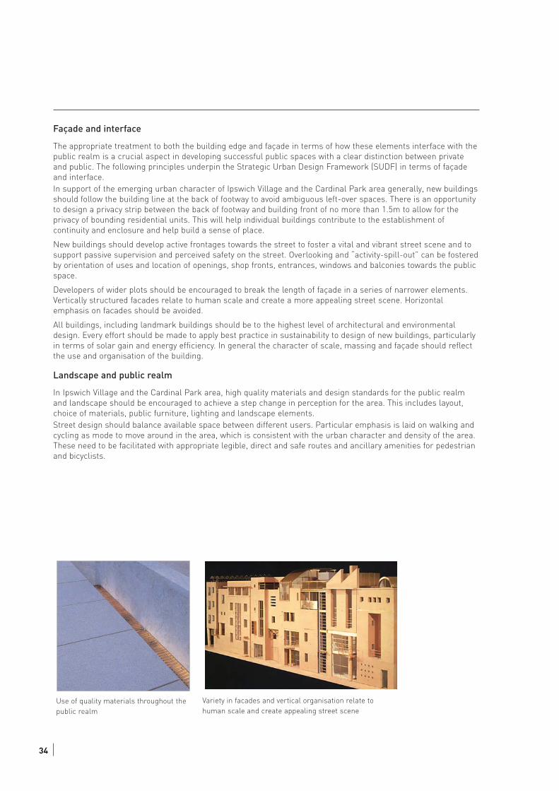
Landscape and public realm
In Ipswich Village and the Cardinal Park area, high quality materials and design standards for the public realm
and landscape should be encouraged to achieve a step change in perception for the area. This includes layout,
choice of materials, public furniture, lighting and landscape elements.
Street design should balance available space between different users. Particular emphasis is laid on walking and
cycling as mode to move around in the area, which is consistent with the urban character and density of the area.
These need to be facilitated with appropriate legible, direct and safe routes and ancillary amenities for pedestrian
and bicyclists.
Use of quality materials throughout the
public realm
Variety in facades and vertical organisation relate to
human scale and create appealing street scene
4.4 TRAFFIC AND MOVEMENT
The overall traffic and movement strategy has been closely linked with the future urban structure and vice versa.
The overall concept seeks to focus transport uses onto principle roads, including Princes Street, Civic Drive, West
End Road / Commercial Road and Hanford Road. These principle routes are generally larger roads and streets
which carry longer distance movement but also provide access to the local area.
Within the principle route network there is a network of secondary routes providing for local access. Many of these
secondary streets exist currently, but importantly the proposed urban structure seeks to provide many more
secondary streets to create a small block size - or tight urban grain. This helps create more connected and
continuous network, thus making the area more walkable.
As many of the current problems occur on Civic Drive and Princes Street, the Corridor Improvements Initiatives
have focused solely on this routes. The full study is found on Appendix C.
Princes Street Corridor
The focus of this corridor is aimed at improving walking links to the town from the station. The station forecourt
area needs to be restructured to improve interchange and free up space for public realm to act as a gateway and
waypoint into the town centre. Princes Street will be improved through footway and landscaping improvements.
The Grafton Way gyratory should be reconsidered with a view to it being removed and replaced by two single traffic
signal junctions. This would mean that Grafton Street, Commercial Way and West End Road would revert to two
way operation. These new junctions would benefit pedestrians through formal crossing points. The movement of
buses can be improved thought the use of Selective Vehicle Technology (SVT).
At its junction with Princes Street, the existing roundabout should be removed and replaced with a more compact
set of traffic signals with surface crossings. Further to the north of Princes Street there is opportunity to control
traffic in the Butter Market area.
Civic Drive Corridor
The main strategy for Civic Drive is break its barrier effect. This is best achieved through a series of junction
improvements along its length and, where practical, reducing road widths.
Junction improvements should be considered at Handford Road, Princes Street (described above) and the Bridge
Street gyratory. Handford Road like Princes Street could be downsized and traffic signals provided, benefiting
pedestrian and maintaining traffic capacity.
The Bridge Lane gyratory will be reconfigured to rationlise the traffic flow and improve walking links particularly
the link to the waterfront. There are a number of junction options described in Appendix C.
Public Transport
There are no major alterations proposed for public transport. The key strategy is the creation of a flexible network
which various operator can use. Bus routing varies over time and flexibility in the network is clearly essential. The
urban structure has been designed to ensure its compatible with the Local Transport Plan II major scheme
proposed.
The Secondary Network
The new secondary network of routes should be developed over time and closely linked with the development of
blocks and plots. Many of these secondary routes will be delivered as development access points, but they are
important because they assist in bulking out the overall network. Close attention must be paid to detail to ensure
that collectively these routes are formed in a continous and well connected way.
1 7 3 5 S T R A T E G I C U R B A N D E S I G N F R A M E W O R K I P S W I C H V I L L A G E / C A R D I N A L P A R K A R E A 35
05 TOWARDS IMPLEMENTATION (this will be a key aspect for further consideration to bring forward the recommendations in this report)
36
Driver of Regeneration
The Ipswich Village Partnership has been established as an informal steering group to bring private, public and
institutional initiatives together with the common aim of making the Ipswich Village and Cardinal Park area more
successful.
This document produces a development vision for the area that would release the significant potential of this area
to become an attractive and vibrant mixed-use quarter alongside the Town Centre. In order to actively steer the
regeneration of an area of this size a concerted and coordinated effort has to be made between all the
development parties. Private and public sector need to go hand in hand and joined up thinking needs to be
promoted.
The bulk of development will be carried out by private investment. There has to be clear development guidance to
aspects of built form and the mix of uses, combined with enforcement, in order to achieve a coherent development
of the area. This is best achieved by a dedicated group representing the key interests with a precise and widely
supported development vision, which similarly is backed by formal planning considerations for this area.
Community support
Community and businesses should be allowed a role in the building of this vision. Consultation with stakeholders
and participation with local resident population and people with interest in the area should be conducted to build
a broad supportive base for the regeneration of this area.
Public sector investment
The public sector has the ability to directly influence the development of the area by using public investment to
create developments of high quality and outstanding architecture. These developments should be of a strategic
nature, present a step change to the area and act as a catalyst, which further attracts people and private
investment. Potential development projects could include new administrative and ancillary developments for
Ipswich Borough Council and possibly other public sector institutions within the Civic Quarter, modern
community sports facilities or a new cultural venue within the Sports and Leisure Quarter, alongside possible
modernisation of the remaining old stands of the football stadium. The key priority will be funding and the
creation of high quality public spaces that signal the change and which become destinations by themselves, help
making the area known and attract businesses and investment into the area.
Public Realm Guidance
To support the development of consistent public realm with a coherent design throughout the area, a public realm
strategy and guidance should be produced. Such a document would identify a hierarchy of streets, outline
principal street layouts in plan and section, and specify design standards, choice of materials, furniture and
lighting. Such a catalogue creates clarity to developers about the required contributions towards the creation or
improvement of the public realm in or adjacent to their development sites. It becomes the basis for a gradual and
independent improvement of the public realm based on private investment that avoids the creation of a patchwork
of various different design standards and materials. Given the substantial development opportunities in the area it
is believed that the majority of public realm improvements could be implemented as part of new developments.
1 7 3 5 S T R A T E G I C U R B A N D E S I G N F R A M E W O R K I P S W I C H V I L L A G E / C A R D I N A L P A R K A R E A 37
Local Transport Plan 2
Major changes to the highways network do require the approval of the highways authority and will largely be
funded by the public sector. During the course of this study it was recognised that the Local Transport Plan 2,
prepared by Faber Maunsell, should incorporate the proposals put forward in this document. This led to the
preparation of a separate document, which is attached to this report in Appendix C, which assessed the
opportunities for improvements of the transport network within the study area. This corridor study identifies a
number of projects that would significantly improve the accessibility of the area from the town centre and the
station in particular for pedestrian. There is an opportunity that these projects will be included in the LTP2 bid
and implemented during the period of this programme. The opening and improvement of pedestrian links into
the area would substantially benefit the development prospects of Ipswich Village and Cardinal Park area as
modern mixed use urban quarter and integrated part of Ipwich Town Centre.
Urban Design Briefs
The second tier of this study was to prepare two more detailed urban design briefs for particular sub areas,
which are in the ownership of IBC. One targeted a site at the riverfront, the other a number of sites adjacent to
the football stadium. Both studies are appendices (A&B) to this report.
As outlined above the council as landholder has the chance to some extent directly to determine form and profile
of potential developments on these sites and should use this opportunity to steer the regeneration of this district.
These Urban Design Brief provide a means to explore the constraints and opportunities of these sites and inform
the Council about potential development options.

App
endi
x A
Urb
an D
esig
n B
rief
Por
tman
Roa
d

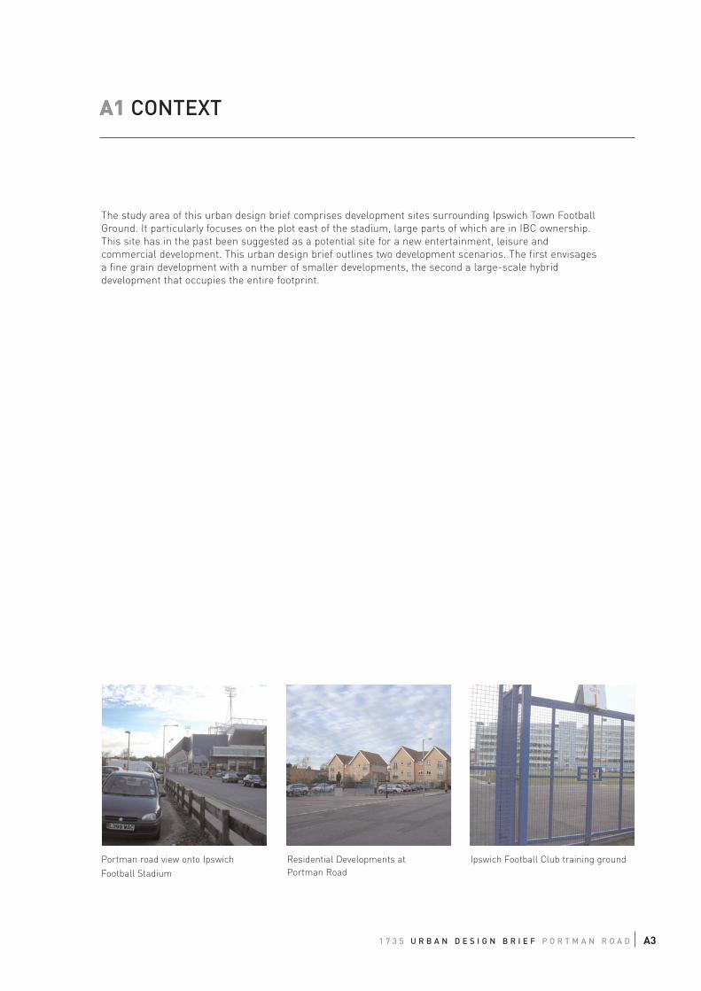
The study area of this urban design brief comprises development sites surrounding Ipswich Town Football
Ground. It particularly focuses on the plot east of the stadium, large parts of which are in IBC ownership.
This site has in the past been suggested as a potential site for a new entertainment, leisure and
commercial development. This urban design brief outlines two development scenarios. The first envisages
a fine grain development with a number of smaller developments, the second a large-scale hybrid
development that occupies the entire footprint.
1 7 3 5 U R B A N D E S I G N B R I E F P O R T M A N R O A D A3
A1 CONTEXT
Portman road view onto Ipswich
Football Stadium
Residential Developments at
Portman Road
Ipswich Football Club training ground
1.2 SITE APPRAISAL
1.2.1. Location
The site is located in Ipswich Village and bounded to the east by Civic Drive, to the south by Princes Street and
Russell Road, to the west by Constantine Road and Alderman Recreation Ground and to the north by Sir Alf
Ramsey Way and Great Gipping Street.
1.2.2. Current Uses
In the centre of the study area sits the Ipswich Town Football Stadium at Portman Road with an attached training
field. There are residential, commercial and institutional land uses located in its surrounding. Significant areas
adjacent to the stadium are currently used as surface car parks by IBC. The redevelopment of these sites offers
the potential to enhance the setting of the Football Stadium and substantially improve the perception of the
Ipswich Village area.
1.2.3. Access and Movement
Portman Road serves as a key access route from the south and north for vehicle and pedestrian movements into
and through the study area. From the west the site can be approached via Sir Alf Ramsey Way off West End Road.
No direct vehicular access is provided from the east off Civic Drive. Similarly, a dedicated and legible pedestrian
link from Ipswich Town Centre via Civic Drive/ Princes Street junction to Sir Alf Ramsey Road is missing. The
current pedestrian and cycle access route via Great Gipping Street is less direct and of a poor quality.
Princes Street at the southern site boundary has the potential to become an attractive pedestrian link from
Ipswich Railway Station into the Town Centre and access from this route for pedestrians should be improved.
On match days Portman Road and Sir Alf Ramsey Way are closed for general traffic. Car parks in Ipswich Village
and the Cardinal Park area serve football supporters arriving by car. There are numerous bus links on Princes
Street and the stadium is in easy reach of Ipswich Railway Station and the Town Centre by foot.
1.2.4. Built Form
The built form throughout the study site area is incoherent and fragmented. The area lacks a legible urban
structure and does not offer a positive character or sense of place. The urban grain is coarse and permeability
within the site and to surrounding districts is low.
A number of developments are of large scale, bulk and height. These include the football stadium, commercial
developments along Civic Drive and the Suffolk County Council developments. These are intermingled with
smaller scale development. However, the development of the area has not used differences in height and massing
to create a legible and distinct townscape. Currently there are a large number of undeveloped plots and stand
alone developments, which are located away from the building line, leading to a weak definition of the street
space with poor enclosure and lack of continuous frontages. The football stadium is a major destination in
Ipswich Village but does not find appropriate expression in the urban structure. It lacks legible entrances and its
frontages towards the public realm are largely uninhabited. It does not contribute to a vibrant and overlooked
street scene.
A4
Civic Quarter
Suffolk CountyCouncil
Cour
t
Ipswich TownFootballStadium
Siteunder development
by IpswichBorough Council
Cine
ma
Recreation Ground
Surface Car Park
1 7 3 5 U R B A N D E S I G N B R I E F P O R T M A N R O A D A5
Figure A1: Context
Primary road network
Secondary road network
Key pedestrian corridor
Pedestrian route
Pedestrian link across car park
Key building
Surface Car Park
Key
1.3. PROGRAMME REQUIREMENTS
The Local Plan (Deposit Draft) and the Area Action Plan envisage the intensification of uses in the Ipswich Village
and its development into a lively mixed use urban quarter. The current emphasis of institutional and leisure uses
are seen as an important driver for the development of the area and should be strengthened. Furthermore there
are opportunities for a mix of new commercial and residential developments. A key requirement of this study is
the development of an appropriate urban structure and framework for the area surrounding the football stadium.
This will allow for the integration of new developments with their surroundings, with Ipswich Town Centre and
with the town’s broader sub regional role. Ipswich Town Football Club has the capacity to attract approximately
30,000 spectators to home matches and pop concerts and the handling of crowds on this scale within the
approaches to the stadium will be a major consideration for the design of an appropriate urban structure.
The surface car park site east of the stadium has the potential to accommodate a high profile leisure development
supplemented by commercial and residential uses. There has been interest in the site for a large-scale leisure or
entertainment complex. Urban Initiatives were requested by IBC to elaborate on two alternative options for this
site, one focusing on a large scale hybrid development, and the other allowing for a finer grain development.
1.4. STRATEGIC URBAN DESIGN FRAMEWORK
The Strategic Urban Design Framework, which has been prepared by Urban Initiatives as part of this study,
outlines Urban design principles for the larger Ipswich Village and Cardinal Park area. It further specifies key
elements of a proposed urban structure, which will support the regeneration and development of this area. Those
of significance for the more narrow study area targeted by this urban design brief are:
1.4.1. Recreation Ground
There is opportunity to develop this green space into an inviting and attractive park, which has the potential to
attract people from surrounding areas. Accessibility needs to be improved and the landscape design should offer
a greater variety of amenities and attractions. It would help to position the park as a destination on the mind map
of the town by giving it a distinctive name.
1.4.2. Princes Street
This corridor links Ipswich Railway Station with Ipswich Town Centre and has the potential to become a primary
access route into and through the study area particularly for pedestrians, cyclists and as a public transport link.
Princes Street needs to be enhanced to create a more pedestrian friendly environment; junctions along the route
require improvement to allow for at-grade and safe pedestrian crossings. The intensification of uses along the
corridor needs to provide appropriate frontages to support a vibrant and vital street scene.
Opportunity for 'Civic Quarter Link'
along Russell Road
A6
IpswichTown
Football
Ground
Park
‘LeisureSquare’
SCC
IBC
Cour
t Loca
l Hub
Trainingground
1 7 3 5 U R B A N D E S I G N B R I E F P O R T M A N R O A D A7
Primary street
Secondary street
Shared surface street for local access only
Key pedestrian route
Proposed / improved public space
Key building
Proposed frontage
Green structure
Potential for landmark development
KeyFigure A2: Proposed Urban Structure as part of SUDF
1.4.3. Pedestrian Links
Besides Princes Street, three other key pedestrian routes pass the study area.
The 'Leisure Spine' links the education quarter in the east, via the waterfront, with the leisure and
entertainment venues in Ipswich Village and the Cardinal Park area and then back into the town centre.
This route offers an attractive approach from the east and is particular targeted on students, visitors and
residents of the waterfront.
The 'Civic Quarter Link' connects the heart of the Civic Quarter in Russell Road via Grafton Way and
Wolsey Street with Ipswich Town Centre and should become an attractive, vibrant and legible route.
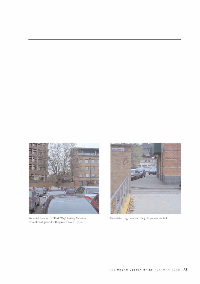
The 'Park Way' connects Alderman Road Recreation Ground via Sir Alf Ramsey Way with Princes Street
and on into Ipswich Town Centre. It requires the creation of a new pedestrian link across the potential
development site east of the football stadium and improvements for pedestrians at the junction Civic Drive
with Princes Street. This link will improve accessibility of the park, raise awareness of this natural asset
and bring people into Ipswich Village.
1.4.4. New Public Spaces with landmark developments
There is an opportunity to develop a network of new public spaces at the intersection of those proposed
pedestrian routes in the area. Built form and public space design should give each public space a distinct
character and identity. There are two major public spaces in the study area. One is situated at the
intersection of Princes Street with the 'Leisure Spine' and 'Civic Quarter Link'. The other sits at the
northeast corner of the football stadium at the intersection of the'Park Link' and 'Leisure Spine'. Both
spaces should be qualified by a distinct landmark development of appropriate height.
1.4.5. Secondary Urban Structure
For successful regeneration into a vibrant and vital mixed use district, “walkability” within and into the
area needs to be improved. This requires the establishment of a finer grain urban structure where
permeability is low. To achieve better connectivity, pedestrian routes need to be continuous and direct, and
offer appropriate pedestrian facilities. In particular, the barrier of the Civic Drive/Franciscan Way corridor
needs to be broken down by creating links that are pleasant and safe and do not require the use of
pedestrian subways. New developments should be located at the back of footway and develop active
frontages, contributing to a vibrant and lively street scene.
A8
1 7 3 5 U R B A N D E S I G N B R I E F P O R T M A N R O A D A9
Potential location of “Park Way” linking Alderton
recreational ground with Ipswich Town Centre
Unsatisfactory, poor and illegible pedestrian link
A2 OUTLINE DEVELOPMENT FRAMEWORK
2.1 LAYOUT OF DEVELOPMENT STRUCTURE
The Strategic Urban Design Framework (SUDF) proposes a new principal layout of streets and spaces for
the Portman Road study area. This breaks the large urban grain into a number of smaller street blocks,
improving permeability and opening up new development potential.
To the south and west of the football ground, it would be possible to significantly improve the setting,
legibility and public access to the stadium. Equally there are opportunities for the development of buildings
on the edge of the current training ground and on the Staples Office site.
The intersection of Portman Road and Russell Road with Princes Street, where the 'Civic Quarter Link'
and the 'Leisure Spine' cross the 'Station Link' should be defined by a new public space. This marks the
physical centre of the Ipswich Village and Cardinal Park area and could become a new local service hub
for people working and living in the area. It should be accentuated by a new landmark development.
The large development site east of the Football Ground is divided into an ensemble of four street-blocks
located around a new public space. This space is strategically positioned at the intersection of the 'Leisure
Spine' and the 'Park Way' and should become the focal centre of new leisure and sports developments in
Ipswich Village. Enclosed by the football stadium and other pedestrian destinations, this square can
become a vibrant and unique character node and create a step change for the perception of the Sports
and Leisure district in Ipswich Village.
Two options were developed for the site bounded to the west by Portman Road, to the south by Princes
Street to the east by Friars Bridge Road and to the North by the new established 'Park Way'.
Option 1
The respective site is divided into two development plots. The realigned Chalon Street is continued across
Princes Street and links up with the corner of the proposed square. This would improve permeability
within the Sports and Leisure Quarter and opens up the opportunity for smaller scale mixed use
developments on these two street blocks, which would enliven the streets with a variety of frontage uses.
Towards the proposed space there is the potential to develop a leisure and entertainment venue within the
boundaries of the block.
Option 2
This Option uses the entire site for a single large-scale entertainment and/or leisure venue. The block
boundaries to the north and east are equal to Option 1. On Princes Street, as shown in Figure A4 , the set-
back of the building line creates a widening of the street space, which would emphasise the main entrance
to the venue for people arriving by car or public transport. The internal circulation should allow for direct
through movement towards the north to offset the loss in permeability. The pedestrian entrance to the
venue should be located off the public square to the north, which similarly could accommodate
supplementary eating and catering uses.
A10
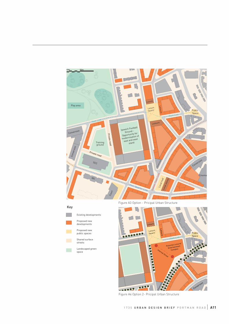
Ipswich Football
Ground -
Opportunity for
modernisation of
east and west
stand
SCC
Cour
t
Conv
ersi
on
`Leisure
Square' PublicSpace
Loca
l sto
res
`Loc
al h
ub`
Conversion
Cinema
Conv
ersi
on
Park Link
Park Link
Leisure Spine
Leis
ure
Link
Stat
ion-
Tow
n-Li
nk
Civic-Quarter-Link
Leisure
Leisure
Play area
Conversion
10m 50m
IBC
Leisure
Trainingground
Private road
Private road
1 7 3 5 U R B A N D E S I G N B R I E F P O R T M A N R O A D A11
`Leisure
Square'
Leisure Public Space
Conversion
Park Link
Conv
ersi
on
LeisureLeisure
Potential Leisure/
Entertainment
ComplexInternal Street
Figure A3 Option - Pricipal Urban Structure
Figure A4 Option 2- Pricipal Urban Structure
Existing developments
Proposed newdevelopments
Proposed newpublic spaces
Shared surfacestreets
Landscaped greenspace
Key
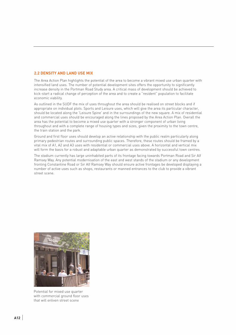
2.2 DENSITY AND LAND USE MIX
The Area Action Plan highlights the potential of the area to become a vibrant mixed use urban quarter with
intensified land uses. The number of potential development sites offers the opportunity to significantly
increase density in the Portman Road Study area. A critical mass of development should be achieved to
kick-start a radical change of perception of the area and to create a “resident” population to facilitate
economic viability.
As outlined in the SUDF the mix of uses throughout the area should be realised on street blocks and if
appropriate on individual plots. Sports and Leisure uses, which will give the area its particular character,
should be located along the 'Leisure Spine' and in the surroundings of the new square. A mix of residential
and commercial uses should be encouraged along the lines proposed by the Area Action Plan. Overall the
area has the potential to become a mixed use quarter with a stronger component of urban living
throughout and with a complete range of housing types and sizes, given the proximity to the town centre,
the train station and the park.
Ground and first floor uses should develop an active relationship with the public realm particularly along
primary pedestrian routes and surrounding public spaces. Therefore, these routes should be framed by a
vital mix of A1, A2 and A3 uses with residential or commercial uses above. A horizontal and vertical mix
will form the basis for a robust and adaptable urban quarter as demonstrated by successful town centres.
The stadium currently has large uninhabited parts of its frontage facing towards Portman Road and Sir Alf
Ramsey Way. Any potential modernisation of the east and west stands of the stadium or any development
fronting Constantine Road or Sir Alf Ramsey Way should ensure active frontages be developed displaying a
number of active uses such as shops, restaurants or manned entrances to the club to provide a vibrant
street scene.
Potential for mixed use quarter
with commercial ground floor uses
that will enliven street scene
A12
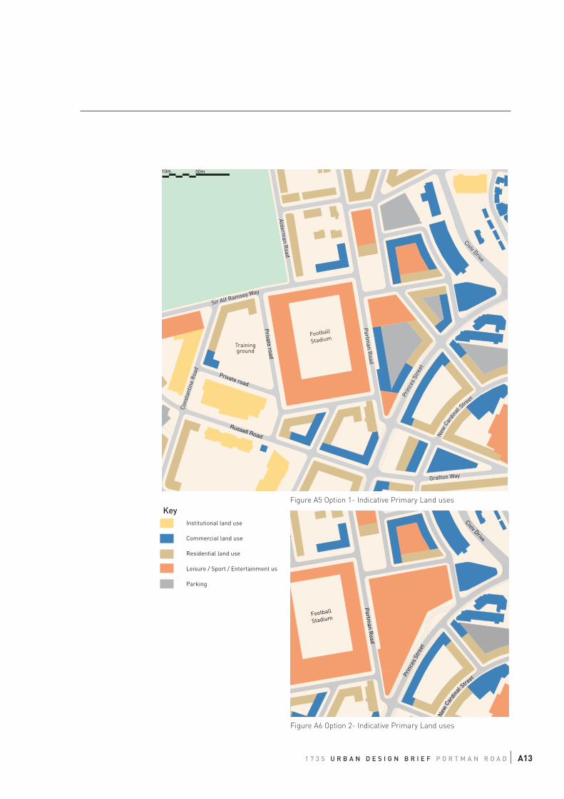
1 7 3 5 U R B A N D E S I G N B R I E F P O R T M A N R O A D A13
10m 50m
Sir Alf Ramsey Way
Portm
an Road
Prin
ces
Stre
et
Civiv Drive
Cons
tant
ine
Roa
d
Grafton Way
New
Cardi
nal Stre
et
Russell Road
Alderman R
oad
Football
StadiumTrainingground
Private road
Private road
Portm
an Road
Prin
ces
Stre
et
Civiv Drive
New
Cardi
nal Stre
et
d
Football
Stadium
Figure A5 Option 1- Indicative Primary Land uses
Figure A6 Option 2- Indicative Primary Land uses
Institutional land use
Commercial land use
Residential land use
Leisure / Sport / Entertainment us
Parking
Key
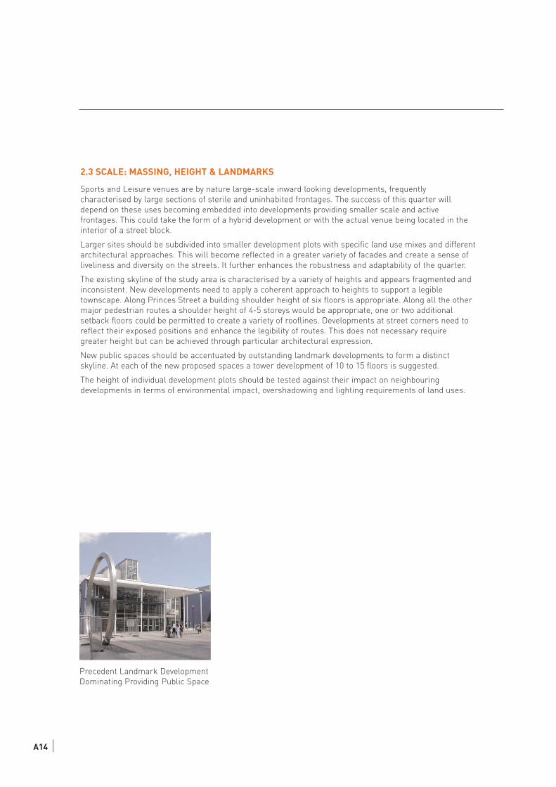
2.3 SCALE: MASSING, HEIGHT & LANDMARKS
Sports and Leisure venues are by nature large-scale inward looking developments, frequently
characterised by large sections of sterile and uninhabited frontages. The success of this quarter will
depend on these uses becoming embedded into developments providing smaller scale and active
frontages. This could take the form of a hybrid development or with the actual venue being located in the
interior of a street block.
Larger sites should be subdivided into smaller development plots with specific land use mixes and different
architectural approaches. This will become reflected in a greater variety of facades and create a sense of
liveliness and diversity on the streets. It further enhances the robustness and adaptability of the quarter.
The existing skyline of the study area is characterised by a variety of heights and appears fragmented and
inconsistent. New developments need to apply a coherent approach to heights to support a legible
townscape. Along Princes Street a building shoulder height of six floors is appropriate. Along all the other
major pedestrian routes a shoulder height of 4-5 storeys would be appropriate, one or two additional
setback floors could be permitted to create a variety of rooflines. Developments at street corners need to
reflect their exposed positions and enhance the legibility of routes. This does not necessary require
greater height but can be achieved through particular architectural expression.
New public spaces should be accentuated by outstanding landmark developments to form a distinct
skyline. At each of the new proposed spaces a tower development of 10 to 15 floors is suggested.
The height of individual development plots should be tested against their impact on neighbouring
developments in terms of environmental impact, overshadowing and lighting requirements of land uses.
A14
Precedent Landmark Development
Dominating Providing Public Space
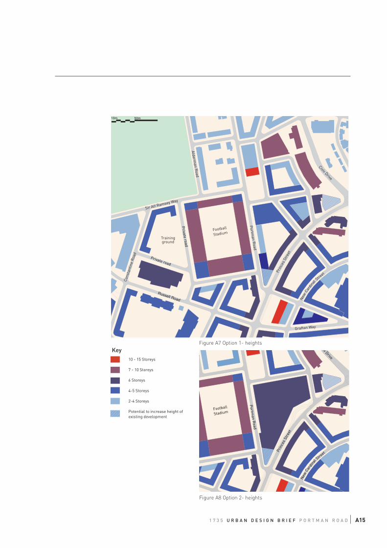
1 7 3 5 U R B A N D E S I G N B R I E F P O R T M A N R O A D A15
10m 50m
Sir Alf Ramsey Way
Portm
an Road
Prin
ces
Stre
et
Civiv Drive
Cons
tant
ine
Roa
d
Grafton Way
New
Cardi
nal Stre
et
Russell Road
Alderman R
oad
Football
StadiumTrainingground
Private road
Private road
Portm
an Road
Prin
ces
Stre
et
iv Drive
New
Cardi
nal Stre
et
d
Football
Stadium
Figure A7 Option 1- heights
Figure A8 Option 2- heights
10 - 15 Storeys
7 - 10 Storeys
6 Storeys
4-5 Storeys
2-4 Storeys
Potential to increase height ofexisting development
Key
2.4 PEDESTRIAN MOVEMENT: ROUTES, PUBLIC REALM AND PUBLIC SPACES, FRONTAGES
The new urban structure is the base for the creation of a legible new townscape in Ipswich Village. New
buildings need to be developed at the back of the building line to create a legible and continuous street
frontage with a clear distinction between private and public spaces without ambiguous leftover spaces.
Throughout the Ipswich Village the public realm must be of a high standard and a consistent design with a
coherent set of materials, furniture and lighting. Pedestrian footpaths should be of appropriate widths,
direct and uncluttered, and offer convenient and safe pedestrian crossings at key routes. The pedestrian
routes 'Station link', 'Leisure Spine', 'Civic Quarter Link' and 'Park Link' should be legible and guide
people to their destination. This can be achieved by different street sections (widths of streets and heights
of buildings), the distinct layout of the street space including street trees, and added elements to the
overall public realm, such as specific lighting or signage elements and variation in surfaces. These
pedestrian routes should be accompanied by facilities for cycling, since these two modes of moving around
urban areas go well together.
The proposed new public spaces in the area need to receive an outstanding and unique public space
design. This should reflect the character and profile of the land uses in the surrounding and provide for
the needs of potential user groups. The installation of feature objects or public art should be explored.
Spaces should invite people for social activities such as gathering, meeting or playing, and similarly offer
space for individual activities such as waiting, observing and relaxing.
Around the football stadium, the gathering of crowds on match or event days needs to be considered. This
requires an open, robust and durable design for these spaces.
2.5 BUILDINGS TO BE RETAINED/ ENHANCED
Although the nightclub building on Princes Street is the only listed building in Ipswich Village, there are a
number of other historic developments within this area that are worth being kept and refurbished because
they contribute to the character of the area and offer economic value by themselves. These include:
2.5.1. Corner building at Princes Street / Portman Road
The entrance porch and roof detail, with a clock, mark this corner and create a legible entrance into
Portman Road. This building together with the converted brick building across the street are reminiscent
features of more industrial uses in the area and give a sense of character. Within a sensible approach
there is an opportunity to retain this character yet substantially increase the height of the building up to
the recommended six floors.
2.5.2. Bus Shed and Constantine House at Constantine Road
This ensemble of historic buildings similarly carries a sense of the historic past of Ipswich Village, and
with its carefully worked out façade lends character to Constantine Road to this end of Sir Alf Ramsey Way.
Constantine House has been converted for Suffolk County Council. The old bus shed similarly offers the
possibility to be retained within a creative refurbishment. Possible value enhancing uses could range from
a gallery, an entertainment venue, a restaurant, creative office spaces or indoor community sports
facilities.
2.5.3. Row of Terraces on Alderman Road
This row of two storey-terraced house lends the surrounding area some sense of place and familiarity. It
represents a pleasant edge to the recreation ground and with its small scale offers an interesting contrast
to the football stadium. The buildings should be retained and integrated within a completed urban block,
which shelters their backsides from the high-density developments east of Portman Road.
A16
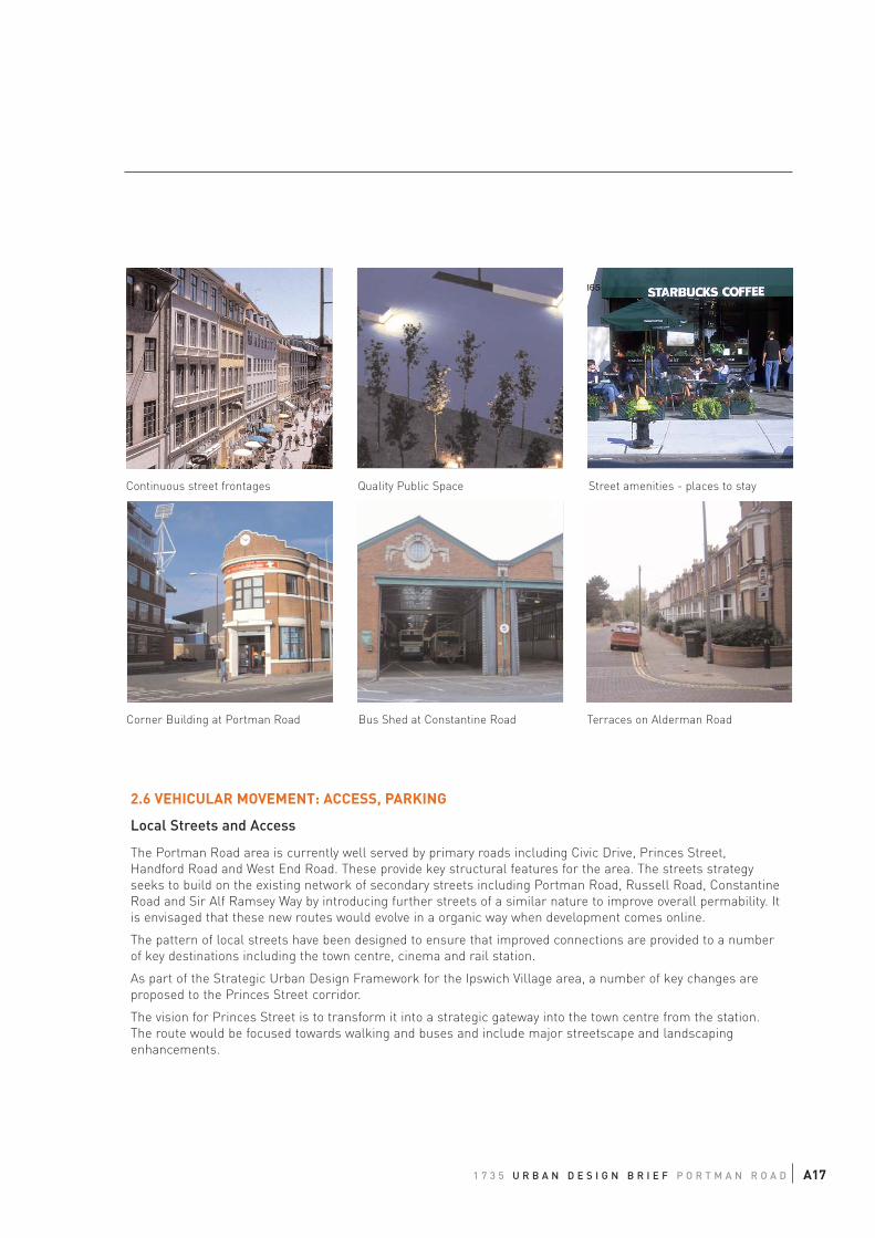
1 7 3 5 U R B A N D E S I G N B R I E F P O R T M A N R O A D A17
Continuous street frontages Quality Public Space
Corner Building at Portman Road Bus Shed at Constantine Road Terraces on Alderman Road
Street amenities - places to stay
2.6 VEHICULAR MOVEMENT: ACCESS, PARKING
Local Streets and Access
The Portman Road area is currently well served by primary roads including Civic Drive, Princes Street,
Handford Road and West End Road. These provide key structural features for the area. The streets strategy
seeks to build on the existing network of secondary streets including Portman Road, Russell Road, Constantine
Road and Sir Alf Ramsey Way by introducing further streets of a similar nature to improve overall permability. It
is envisaged that these new routes would evolve in a organic way when development comes online.
The pattern of local streets have been designed to ensure that improved connections are provided to a number
of key destinations including the town centre, cinema and rail station.
As part of the Strategic Urban Design Framework for the Ipswich Village area, a number of key changes are
proposed to the Princes Street corridor.
The vision for Princes Street is to transform it into a strategic gateway into the town centre from the station.
The route would be focused towards walking and buses and include major streetscape and landscaping
enhancements.
A18
The Grafton Way gyratory could be removed and replaced by two traffic signal junctions. That would mean that
Grafton Street, Commercial Way and West End Road would revert to two way operation. These new junctions
would benefit pedestrians through formal crossing points. The movement of buses could be improved through the
use of Selective Vehicle Technology (SVT).
At the junction of Civic Drive with Princes Street, the existing roundabout will be removed and replaced with a
more compact set of traffic signals with surface crossings.
It is envisaged that Princes Street would become a focus for public transport for the local area, with a series of
bus hubs along its length being fed by the various secondary streets.
The majority of these major alterations will be delivered through public sector funding, however a contribution
should be sought from local developers.
Parking
There are a number of large on street car parks in the area. It is considered that the overall public parking stock
should be maintained through re-provision of parking where necessary.
For new development, car parking should be based on local standards which are restraint based. Where possible
consideration should be given to sharing of car parking, particularly between land uses. On street parking should
be controlled.
Match Day Traffic Management
On matchdays Portman Road should continue to remain closed to motorised traffic. The new network of permable
streets has the potential to improve the way pedestrians move and circulate around the stadium.
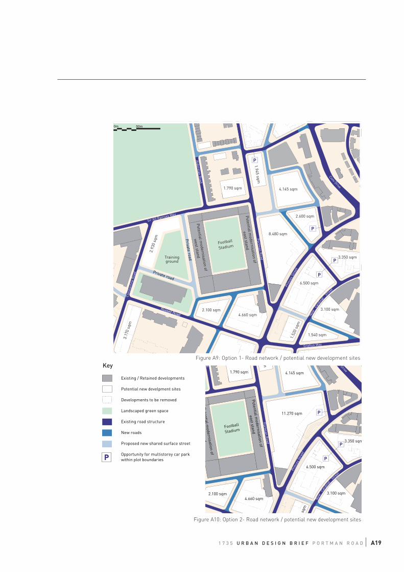
1 7 3 5 U R B A N D E S I G N B R I E F P O R T M A N R O A D A19
1.540 sqm
3.100 sqm
6.500 sqm
4.660 sqm2.100 sqm
1.52
0 sq
m
3.17
0 sq
m
3.350 sqm
0m 50m
Football
Stadium
1.790 sqm
Potential m
odernisation of
east stand
Potential m
odernisation of
west stand
Sir Alf Ramsey Way
Portm
an Road
Prin
ces
Stre
et
Civiv Drive
Con
stan
tine
Roa
d
Grafton Way
New
Cardi
nal
Street
Russell Road
Alderman R
oad
8.480 sqm
2.600 sqm
P
P
P
1.945 sqm
4.145 sqm
P
2.93
0 sq
m
Trainingground
Private road
Private road
11.270 sqm
3.100 sqm
6.500 sqm
4.660 sqm2.100 sqm
0sq
m
3.350 sqm
Football
Stadium
1.790 sqm
Potential m
odernisation of
east stand
Potential m
odernisation of
d
P
P
Portm
an Road
Prin
ces
Stre
et
v Drive
New
Cardi
nal
Street
d m
4.145 sqm
P
Figure A9: Option 1- Road network / potential new development sites
Figure A10: Option 2- Road network / potential new development sites
Existing / Retained developments
Potential new develpment sites
Developments to be removed
Landscaped green space
Existing road structure
New roads
Proposed new shared surface street
Opportunity for multistorey car parkwithin plot boundariesPP
Key

App
endi
x B
Urb
an D
esig
n B
rief
Wes
t En
d R
oad
Car
Par
k

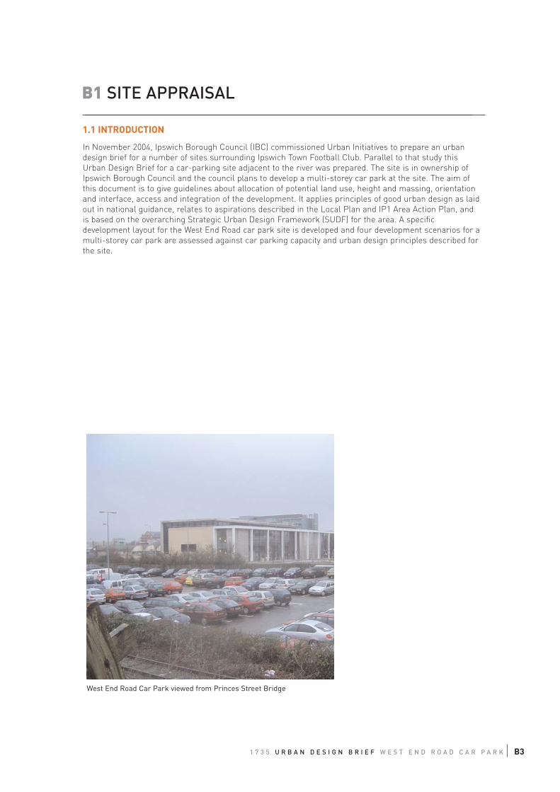
1 7 3 5 U R B A N D E S I G N B R I E F W E S T E N D R O A D C A R P A R K B3
B1 SITE APPRAISAL
1.1 INTRODUCTION
In November 2004, Ipswich Borough Council (IBC) commissioned Urban Initiatives to prepare an urban
design brief for a number of sites surrounding Ipswich Town Football Club. Parallel to that study this
Urban Design Brief for a car-parking site adjacent to the river was prepared. The site is in ownership of
Ipswich Borough Council and the council plans to develop a multi-storey car park at the site. The aim of
this document is to give guidelines about allocation of potential land use, height and massing, orientation
and interface, access and integration of the development. It applies principles of good urban design as laid
out in national guidance, relates to aspirations described in the Local Plan and IP1 Area Action Plan, and
is based on the overarching Strategic Urban Design Framework (SUDF) for the area. A specific
development layout for the West End Road car park site is developed and four development scenarios for a
multi-storey car park are assessed against car parking capacity and urban design principles described for
the site.
West End Road Car Park viewed from Princes Street Bridge
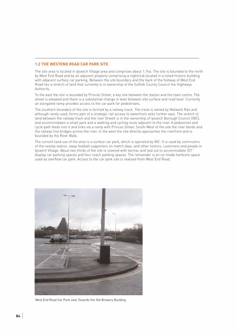
B4
1.2 THE WESTEND ROAD CAR PARK SITE
The site area is located in Ipswich Village area and comprises about 1.1ha. The site is bounded to the north
by West End Road and by an adjacent property comprising a nightclub located in a listed historic building
with adjacent surface car parking. Between the site boundary and the back of the footway of West End
Road lies a stretch of land that currently is in ownership of the Suffolk County Council the Highways
Authority.
To the east the site is bounded by Princes Street, a key link between the station and the town centre. The
street is elevated and there is a substantial change in level between site surface and road level. Currently
an elongated ramp provides access to the car park for pedestrians.
The southern boundary of the site is formed by a railway track. The track is owned by Network Rail and
although rarely used, forms part of a strategic rail access to waterfront sites further east. The stretch of
land between the railway track and the river Orwell is in the ownership of Ipswich Borough Council (IBC),
and accommodates a small park and a walking and cycling route adjacent to the river. A pedestrian and
cycle path feeds into it and links via a ramp with Princes Street. South-West of the site the river bends and
the railway line bridges across the river. In the west the site directly approaches the riverfront and is
bounded by the River Walk.
The current land use of the area is a surface car park, which is operated by IBC. It is used by commuters
of the nearby station, away football supporters on match days, and other visitors, customers and people in
Ipswich Village. About two thirds of the site is covered with tarmac and laid out to accommodate 307
display car parking spaces and four coach parking spaces. The remainder is an un-made hardcore space
used as overflow car park. Access to the car park site is realised from West End Road.
West End Road Car Park view Towards the Old Brewery Building
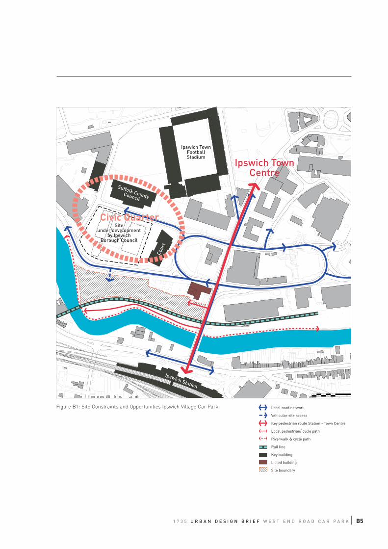
10m
50m
10m
10m
10m
10m
Siteunder development
by IpswichBorough Council
Suffolk CountyCouncil
Cour
t
Ipswich TownFootballStadium
Ipswich Station
Ipswich TownCentre
Civic Quarter
Figure B1: Site Constraints and Opportunities Ipswich Village Car Park Local road network
Vehicular site access
Key pedestrian route Station - Town Centre
Local pedestrian/ cycle path
Riverwalk & cycle path
Rail line
Key building
Listed building
Site boundary
1 7 3 5 U R B A N D E S I G N B R I E F W E S T E N D R O A D C A R P A R K B5
1.3 CONSTRAINTS
Electricity Cable
There is an underground high voltage cable running across the site from the northwest corner to the
bridge in the east. This cable needs to be removed in order to allow for building activities on the site.
The replacement of the cable from the site to a new track along West End Road and Princes Street is
currently being investigated by IBC.
Flood Protection
The car parking site lies inside the current flood protection line. Flood protection is reported not to
constrain the current use as surface carpark. However, if a change in land use is proposed the degree
of flood protection for these uses on site will need to be investigated.
Railway Tracks
Currently access from the south to the site is restricted due to a fenced off railway line.
The potential dismantling of this line would offer the opportunity to create a new access street on the
previous track, which would allow the development of served and active frontages along the river. This
option should be considered in the long term to support regeneration of the riverfront. As an
intermediate option, the opportunity of establishing secured at-grade pedestrian crossings with the
railway track should be tested, to allow for site access from and to the riverside walk.
Shape & Access constraints
The long and narrow shape of the site will constrain the possible layout for development.
Vehicular access can only be realised off West End Road and is further constrained by different
landownerships. Given the traffic function of Princes Street and the available road width, the site can be
only accessed by pedestrians from the Princes Street bridge level.
From the western side pedestrians can approach the site from the riverside walk. There is the
opportunity to establish a service road off West End Road, which could facilitate vehicular access at this
side.
1.4 PROGRAMME REQUIREMENTS
The brief from the Borough Council requires the accommodation of 1000 parking spaces in a multi-
storey car park on the site. The Council is in the process of moving their offices to Russell Road north of
the site. The programme for the development assumes occupation of the new offices in 2006.
Towards Princes Street the development of a retail frontage is being considered. The western part of the
site could accommodate a residential development. This part of the site would be subject to a
public/private sector development agreement.
B6
1 7 3 5 U R B A N D E S I G N B R I E F W E S T E N D R O A D C A R P A R K
1.5 STRATEGIC URBAN DESIGN FRAMEWORK OVERARCHING URBAN DESIGN PRINCIPLES
The Strategic Urban Design Framework, which forms the basis for this urban design brief, specifies key
elements of the urban structure. Those with an impact on the study area site are outlined in greater
detail below:
Key elements of Urban Structure
Princes Street
Princes Street forms the link between Ipswich Railway Station and Ipswich Town Centre. It is proposed
to enhance its role as a pedestrian route by developing a quality public realm along the street in the
form of a tree-lined boulevard. New developments along Princes Street will be required to be built at
the back of footway establishing active frontages to the Princes Street corridor to support an active and
safe street scene.
At key nodes along the corridor new public spaces are proposed. These facilitate the route with
pedestrian amenities and are to become local hubs and centres of emerging character areas. This site
is located between two proposed spaces, the station square and a space at the intersection with Grafton
Way and Portman Road.
Riverfront
The land between the river and railway line currently forms a natural park, a parallel river walk and a
flood defence structure. The landscape design is poor and the area lacks appropriate maintenance. In
line with planning aspirations by IBC (Ipswich Local Plan Review First Deposit Draft, IP1 Area Action
Plan) and the local River Action Group, the SUDF proposes the creation of an integrated new “Riverfront
Park”. It is to become an attractive green edge to the expanding town centre, which offers recreational
and atmospheric qualities for passers-by and local residents.
Allowing access from Ipswich Village and Cardinal Park areas will be crucial for the success and vitality
of the park. In the short term, access will be limited due to the existing railway line. However, emerging
developments bounding the riverfront area need to create appropriate preconditions to enable legible
and direct access to the riverfront in the longer term. Intermediate options to access the park across
the operable rail line by means of at grade pedestrian crossings should be investigated.
New buildings need to facilitate overlooking and passive surveillance of the “Riverfront Park” area.
Active frontage uses should be established with openings, windows and entrances facing the park. The
long term aspiration is to create a shared surface street at the position of the current railway track to
provide vehicular and pedestrian access to building fronts and the park. This would require the
dismantling of the railway track or a design and management arrangement with rail and other users
sharing the same space. In the short term pedestrian access to building fronts need to be realised on
the landside of the railway or equally by linking across to the existing river walk and cycle route.
Along the Riverfront Park area, buildings should be generally orientated towards the riverfront and
create a continuous frontage. Elements of hard surfacing within the park may be appropriate to provide
some outdoor amenity or sitting out areas for commercial use (e.g. cafes). A variety of heights and
roofscape treatments will create a distinctive building frontage and skyline typical of Ipswich Town
Centre.
This riverside is highly visible, particular in the vicinity of bridges, such as Princes Street Bridge, and
Bridge Street, and the potential building line along the riverfront forms the flanks of a gateway into the
Town Centre. The representational function of these entrance points should not be understated and find
expression in a high quality design and appropriate landmark configuration.
B7
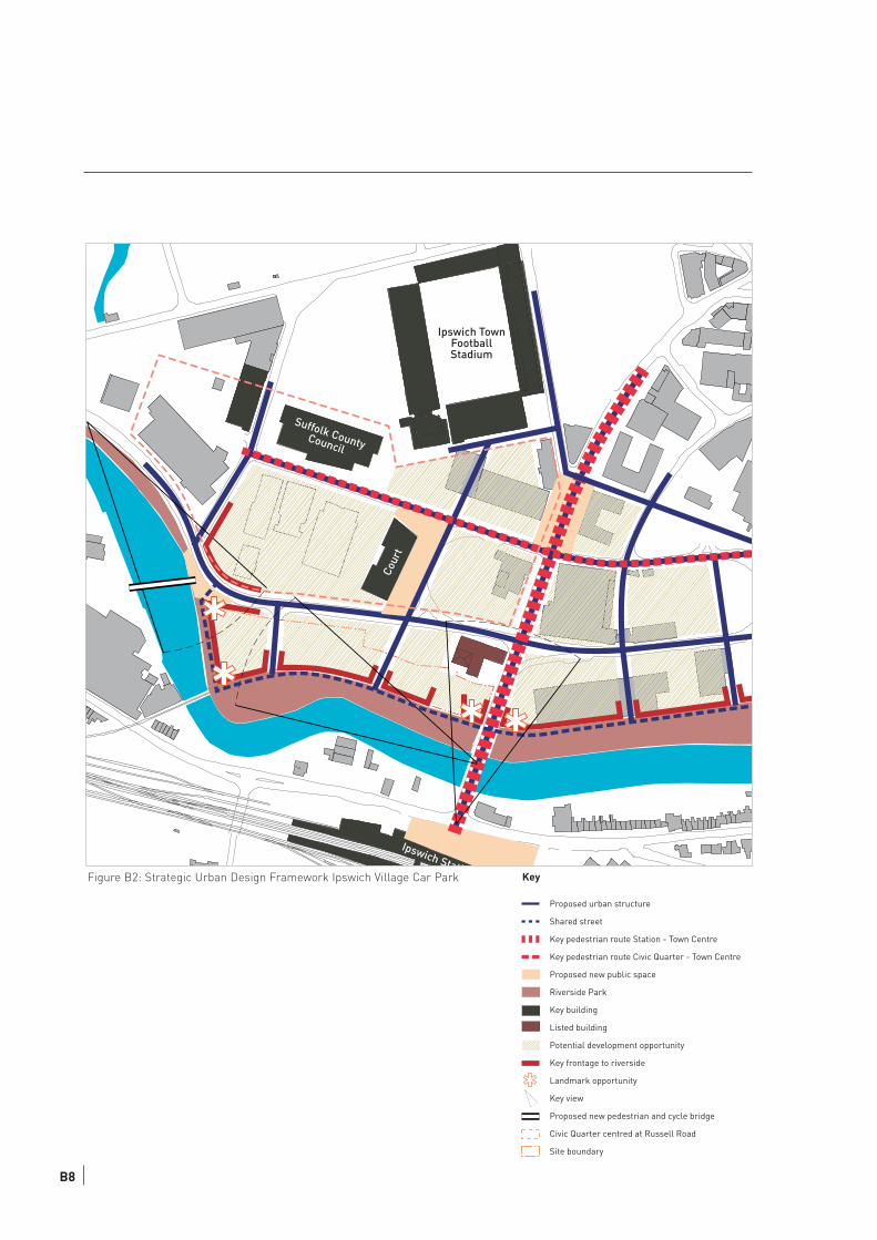
Suffolk CountyCouncil
Cour
t
Ipswich TownFootballStadium
Ipswich StatiFigure B2: Strategic Urban Design Framework Ipswich Village Car Park Key
Proposed urban structure
Shared street
Key pedestrian route Station - Town Centre
Key pedestrian route Civic Quarter - Town Centre
Proposed new public space
Riverside Park
Key building
Listed building
Potential development opportunity
Key frontage to riverside
Landmark opportunity
Key view
Proposed new pedestrian and cycle bridge
Civic Quarter centred at Russell Road
Site boundary
B8
1 7 3 5 U R B A N D E S I G N B R I E F W E S T E N D R O A D C A R P A R K
Public Sector Quarter
Within Ipswich Village a new Public Sector Quarter is emerging. Suffolk County Council have already
moved offices there, the Crown Court also occupies a purpose built development nearby. Ipswich
Borough Council will also be relocating their offices to the area in 2006. This cluster of public
institutions is concentrated in the vicinity of Russell Road. The SUDF highlights the opportunity to
improve the public realm along this road and to create an attractive setting and pleasant environment
for these land uses. Further it proposes measures to better integrate this road in the urban structure of
Ipswich Village and to establish a continuous pedestrian route from Ipswich Town via Cardinal Park/
Multiplex Cinema into the Public Quarter and further north to the Recreational Ground at Sir Alf
Ramsey Way.
In terms of character, the Public Sector Quarter should be open and inviting and foster elements of
public pride. This is expected to find expression in a quality design solution both in architecture and
public realm components. To contribute to place making and achieve coherency across the entire
Ipswich Village, new developments are required to apply high standards of design.
Secondary Urban Structure
As part of the SUDF a new secondary urban structure is proposed for Ipswich Village/ Cardinal Park
area. These proposals should be developed when the opportunity arises in association with
developments on neighbouring sites. Based on the existing street network a number of new streets and
links are proposed. From the preceding urban design analysis the need for a finer grain urban structure
becomes apparent. A finer grain increases permeability and eases the movement around the area. It
expands the opportunity for development with accessible frontages. It adds to adaptability and
robustness of the area by offering a greater number of smaller development opportunities with
accessible frontage spaces.
B9
B2 OUTLINE DEVELOPMENT FRAMEWORK
The Strategic Urban Design Framework is the foundation of the Ipswich Village West End Road Car
Park design brief, whose components are described below. The development framework covers a
larger site than the one currently owned by IBC and is bounded by West End Road to the north, Princes
Street to the west and the river Orwell to south and west. This will allow the development of an
integrated urban design solution for the entire site at this exposed location at the Riverfront.
2.1 LAYOUT OF DEVELOPMENT STRUCTURE
The site should be seen as three plots subdivided by two north-south streets. The proposed urban
typology is the perimeter block, which offers flexibility in plot-subdivision, building depth and landuse-
mix. It creates a legible street space and clear distinction between private and public zones.
The perimeter block is generally bounded by the back of footway, in case of residential development a
set back of 1.5m is permitted for privacy. To the north a continuous straight building frontage is
established along West End Road. To the south the building line follows a 6m threshold space from the
centre of the rail line. This creates a distinct curve frontage that expresses the riverbank, and further
allows for efficient use of available space. In the west the building front follows the river and to the east
the development plot is determined by Princes Street Bridge.
A listed Grade II historic building currently occupied by a nightclub, is located in the corner of West End
Road and Princes Street. The original building features a dominant Malting Tower in its south-west
corner. The proposed development plots enclose the building from two sides and create a composition
of two spaces that are dominated by the historic structure. This layout relates in particular to the
visibility of the significant landmark tower from Princes Street Bridge and the riverbank.
The listed building would form a heart of a local character area that could serve Ipswich Public Sector
Quarter and surrounding uses with restaurant, café and similar facilities. The new open space is
sheltered on three sides, opens to south and faces the riverfront. The space is visible from Princes
Street yet protected from direct environmental impact of this street such as noise and movement. It
creates ideal conditions to extend restaurant and bar uses into the open space with serviced outdoor
spaces and other sitting out amenities keeping an appropriate balance. The creation of a
restaurant/café destination at the northern bridgehead would realise a step change for the area and its
perception, and could act as catalyst for further development in the surrounding area.
B10
1 7 3 5 U R B A N D E S I G N B R I E F W E S T E N D R O A D C A R P A R K
West End Road
Prin
ces
Stre
et
Nor
th S
outh
Lin
k St
reet
1
Nor
th S
outh
Lin
k St
reet
2
New publicspace
Block A Block B
Block C
Old Brewery
New
public space
Proposed new “Riverside Park”
River
Proposed new bridge
to Compair Development
KeyKey
Proposed building block (with indicative coutyard space)
Proposed pedstrian space
Refurbishement of listed building
Current rail line / proposed future shared surface street
Proposed RiverSide Park
Site Boundary
Proposed building block (with indicative coutyard space)
Proposed pedstrian space
Refurbishement of listed building
Current rail line / proposed future shared surface street
Proposed RiverSide Park
Site Boundary
Figure B3: Development Structure
B11
2.2 SCALE: HEIGHT & MASSING, LANDMARKS
The site is bounded by the riverfront and a proposed riverside park. Given the exposed location
overlooking the open space to the riverside, a building shoulder height of seven floors is recommended.
Towards West End Street and the proposed two site access streets generally the shoulder height can be
up to six storeys with an additional floor that is set back. However individual design solutions need to be
tested against privacy and lighting requirements associated with proposed land uses.
The building overlooking the river side in the west forms the end of a continuous stretch of proposed new
riverfront developments and should reflect this exceptional position. Additionally the exposed location in a
distinct curve of the river offers high visibility of this site from across the river. This front and the
respective northern and southern corner of the block should echo this condition through a landmark
development of high quality architecture and the potential to step up the corners with two additional
floors.
The east end of the site bounds the bridgehead and encloses the listed building. A new landmark
development of up to 10 storeys is proposed. A tall structure at this point will emphasise the entrance into
Ipswich Village and form a gateway into the Town Centre. The new developments need to create a
balanced composition with the listed building in relation to scale, frontage heights, materials and degree
of detail.
The view of the malting tower from Princes Street Bridge on the station side needs to be protected. The
environmental/micro-climatic impact of a new tower on its surrounding and in particular the proposed
new public space needs to be tested to avoid the creation of adverse conditions.
2.3 VEHICULAR MOVEMENT: ACCESS, PARKING
Vehicular access to the site will be secured from West End Road via the existing western and a proposed
new eastern access street as indicated in Figure 5. The long-term aspiration would be the development of
a continuous shared surface service street between new building front and the riverfront park on the
current railway track. This street would connect both access streets with other development sites east of
the Princes Street Bridge by reusing the existing railway underpass. In the west this street serves
frontages overlooking the river and links back into West End Road. Beside offering access to development
sites these three north-south streets create a greater degree of permeability and are vital access routes
to the riverfront park. Therefore they should be designed and managed as legible public routes and
facilitated with appropriate pedestrian spaces.
The scarcity of available street space and constrained access conditions mean that the majority of
required car parking to accord with IBC car parking standards needs to be accommodated on site.
Undercroft, decked solutions in inner courts and enclosed multi-storey solutions are options that should
be explored. Visual and environmentally intrusive car parking solutions will have an adverse impact on the
perception, character and attractiveness of the site and should be avoided.
B12
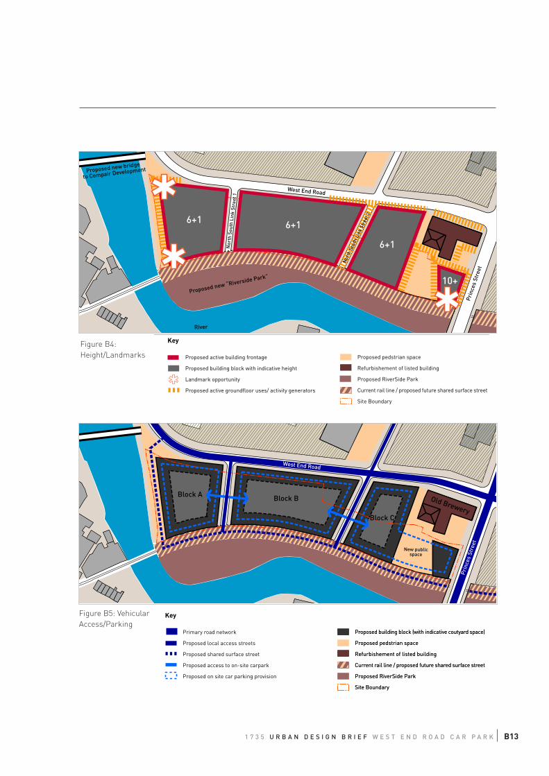
1 7 3 5 U R B A N D E S I G N B R I E F W E S T E N D R O A D C A R P A R K
6+1 6+1
6+1
10+
West End Road
Prin
ces
Stre
et
Nor
th S
outh
Lin
k St
reet
1
Nor
th S
outh
Lin
k St
reet
2
Proposed new “Riverside Park”
River
Proposed new bridge
to Compair Development
New publicspace
Block A Block B
Block C
Old Brewery
West End RoadPr
ince
s St
reet
Key
Proposed active building frontage
Proposed building block with indicative height
Landmark opportunity
Proposed active groundfloor uses/ activity generators
Proposed pedstrian space
Refurbishement of listed building
Proposed RiverSide Park
Current rail line / proposed future shared surface street
Site Boundary
Proposed building block (with indicative coutyard space)
Proposed pedstrian space
Refurbishement of listed building
Current rail line / proposed future shared surface street
Proposed RiverSide Park
Site Boundary
Proposed building block (with indicative coutyard space)
Proposed pedstrian space
Refurbishement of listed building
Current rail line / proposed future shared surface street
Proposed RiverSide Park
Site Boundary
Key
Primary road network
Proposed local access streets
Proposed shared surface street
Proposed access to on-site carpark
Proposed on site car parking provision
Figure B4:
Height/Landmarks
Figure B5: Vehicular
Access/Parking
B13
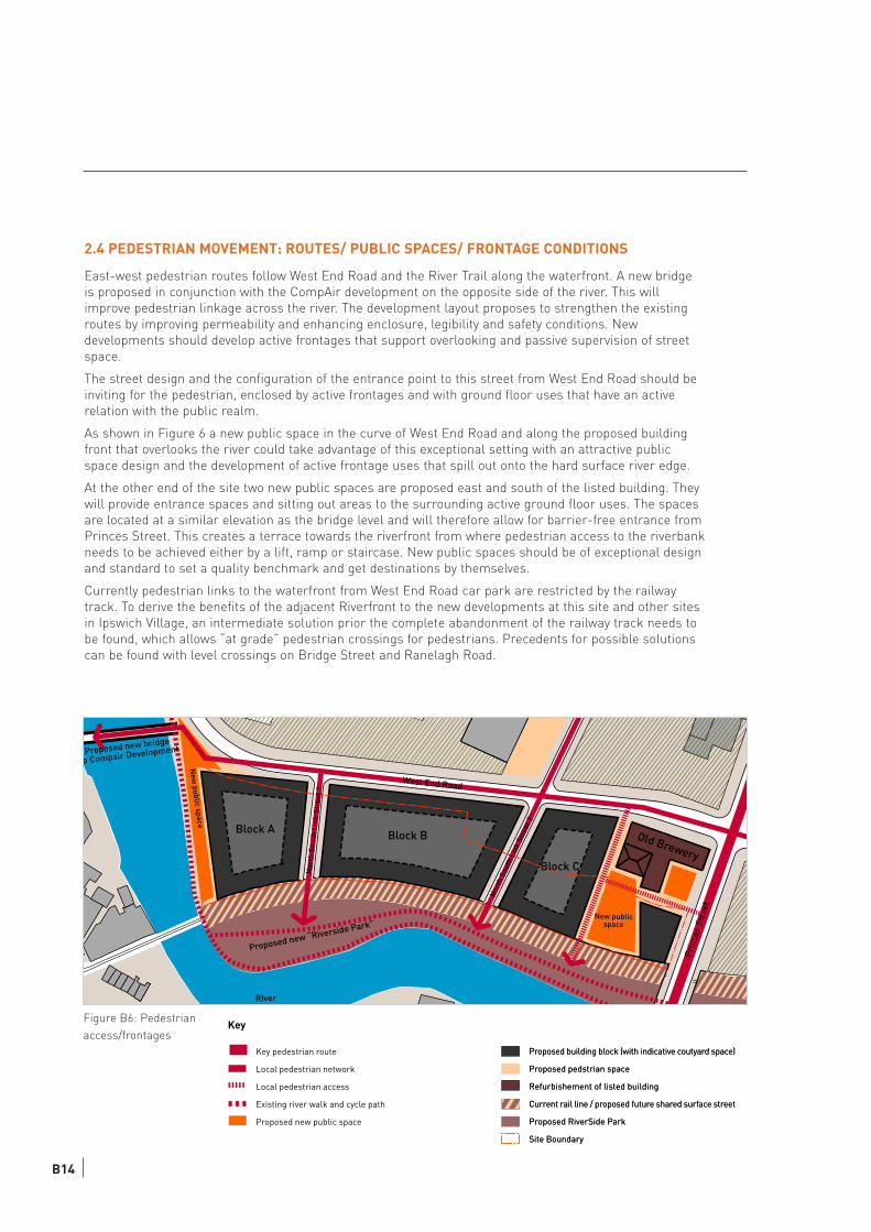
2.4 PEDESTRIAN MOVEMENT: ROUTES/ PUBLIC SPACES/ FRONTAGE CONDITIONS
East-west pedestrian routes follow West End Road and the River Trail along the waterfront. A new bridge
is proposed in conjunction with the CompAir development on the opposite side of the river. This will
improve pedestrian linkage across the river. The development layout proposes to strengthen the existing
routes by improving permeability and enhancing enclosure, legibility and safety conditions. New
developments should develop active frontages that support overlooking and passive supervision of street
space.
The street design and the configuration of the entrance point to this street from West End Road should be
inviting for the pedestrian, enclosed by active frontages and with ground floor uses that have an active
relation with the public realm.
As shown in Figure 6 a new public space in the curve of West End Road and along the proposed building
front that overlooks the river could take advantage of this exceptional setting with an attractive public
space design and the development of active frontage uses that spill out onto the hard surface river edge.
At the other end of the site two new public spaces are proposed east and south of the listed building. They
will provide entrance spaces and sitting out areas to the surrounding active ground floor uses. The spaces
are located at a similar elevation as the bridge level and will therefore allow for barrier-free entrance from
Princes Street. This creates a terrace towards the riverfront from where pedestrian access to the riverbank
needs to be achieved either by a lift, ramp or staircase. New public spaces should be of exceptional design
and standard to set a quality benchmark and get destinations by themselves.
Currently pedestrian links to the waterfront from West End Road car park are restricted by the railway
track. To derive the benefits of the adjacent Riverfront to the new developments at this site and other sites
in Ipswich Village, an intermediate solution prior the complete abandonment of the railway track needs to
be found, which allows “at grade” pedestrian crossings for pedestrians. Precedents for possible solutions
can be found with level crossings on Bridge Street and Ranelagh Road.
West End Road
Prin
ces
Stre
et
Nor
th S
outh
Lin
k St
reet
1
Nor
th S
outh
Lin
k St
reet
2
New publicspace
Block A Block B
Block C
Old Brewery
New
public space
Proposed new “Riverside Park”
River
Proposed new bridge
o Compair Development
Figure B6: Pedestrian
access/frontages
Proposed building block (with indicative coutyard space)
Proposed pedstrian space
Refurbishement of listed building
Current rail line / proposed future shared surface street
Proposed RiverSide Park
Site Boundary
Proposed building block (with indicative coutyard space)
Proposed pedstrian space
Refurbishement of listed building
Current rail line / proposed future shared surface street
Proposed RiverSide Park
Site Boundary
Key
Key pedestrian route
Local pedestrian network
Local pedestrian access
Existing river walk and cycle path
Proposed new public space
B14
2.5 LAND USE CONSIDERATIONS
In terms of location this site offers outstanding conditions for high quality riverfront developments. The
site lies within walking distance from Ipswich Station and the Town Centre. It is highly accessible by
public transport and well integrated in the highway network of the town. The site itself is highly visible,
offers outstanding uninterrupted views to the riverside from a long south facing frontage, and is
bounded by the recreational amenity of the riverfront park.
These conditions make the site suitable for upward residential development facing the riverside and
mixed residential and commercial uses towards the remaining frontages. There is opportunity to
establish active retail and commercial ground floor uses in particular of eatery businesses and small
scale convenience shopping.
There is a clear requirement for a multi-storey car park that serves the Public Sector Quarter, and there
is no doubt about the benefits of a car park in this location for rail-commuters and football supporters.
The aspirations for a multi-storey car park at the West End Road car park site are supported for a
number of reasons:
- the site is in ownership of IBC, has been used as a 300-space car park already and is zoned for car-
park use in the current statutory Local Plan;
- the site does not need clearance and after the removal of the underground electricity-main is in
principle ready for development;
- the current flood protection is adequate for car parking use at the site.
1 7 3 5 U R B A N D E S I G N B R I E F W E S T E N D R O A D C A R P A R K B15
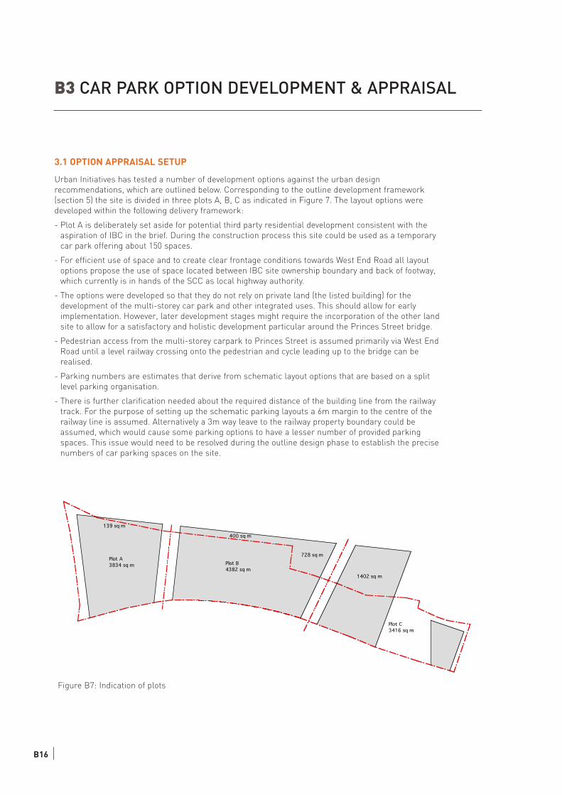
Plot A
3834 sq m Plot B
4382 sq m
Plot C
3416 sq m
1402 sq m
728 sq m
139 sq m
400 sq m
B3 CAR PARK OPTION DEVELOPMENT & APPRAISAL
3.1 OPTION APPRAISAL SETUP
Urban Initiatives has tested a number of development options against the urban design
recommendations, which are outlined below. Corresponding to the outline development framework
(section 5) the site is divided in three plots A, B, C as indicated in Figure 7. The layout options were
developed within the following delivery framework:
- Plot A is deliberately set aside for potential third party residential development consistent with the
aspiration of IBC in the brief. During the construction process this site could be used as a temporary
car park offering about 150 spaces.
- For efficient use of space and to create clear frontage conditions towards West End Road all layout
options propose the use of space located between IBC site ownership boundary and back of footway,
which currently is in hands of the SCC as local highway authority.
- The options were developed so that they do not rely on private land (the listed building) for the
development of the multi-storey car park and other integrated uses. This should allow for early
implementation. However, later development stages might require the incorporation of the other land
site to allow for a satisfactory and holistic development particular around the Princes Street bridge.
- Pedestrian access from the multi-storey carpark to Princes Street is assumed primarily via West End
Road until a level railway crossing onto the pedestrian and cycle leading up to the bridge can be
realised.
- Parking numbers are estimates that derive from schematic layout options that are based on a split
level parking organisation.
- There is further clarification needed about the required distance of the building line from the railway
track. For the purpose of setting up the schematic parking layouts a 6m margin to the centre of the
railway line is assumed. Alternatively a 3m way leave to the railway property boundary could be
assumed, which would cause some parking options to have a lesser number of provided parking
spaces. This issue would need to be resolved during the outline design phase to establish the precise
numbers of car parking spaces on the site.
Figure B7: Indication of plots
B16
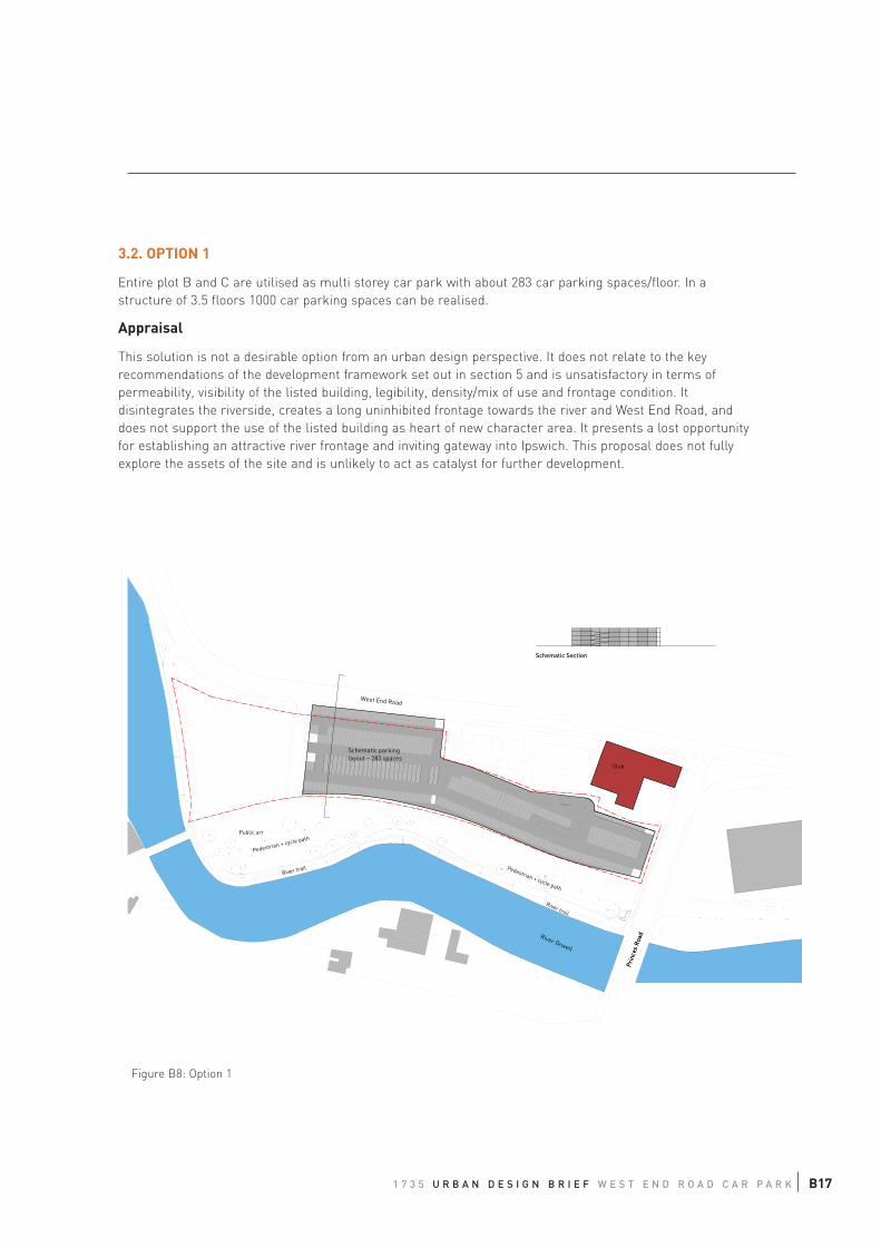
3.2. OPTION 1
Entire plot B and C are utilised as multi storey car park with about 283 car parking spaces/floor. In a
structure of 3.5 floors 1000 car parking spaces can be realised.
Appraisal
This solution is not a desirable option from an urban design perspective. It does not relate to the key
recommendations of the development framework set out in section 5 and is unsatisfactory in terms of
permeability, visibility of the listed building, legibility, density/mix of use and frontage condition. It
disintegrates the riverside, creates a long uninhibited frontage towards the river and West End Road, and
does not support the use of the listed building as heart of new character area. It presents a lost opportunity
for establishing an attractive river frontage and inviting gateway into Ipswich. This proposal does not fully
explore the assets of the site and is unlikely to act as catalyst for further development.
Schematic parkinglayout ~ 283 spaces
PrincesRoad
Public art
Pedestrian + c
ycle path
River trail
West End Road
River Orwell
N
Option 1
Pedestrian + cycle path
River trail
10m50m
10m10m
10m10m
Club
Buildings potentiallyremoved
Firestation
PrincesRoad
10m50m
10m10m
10m10m
Schematic Section
Figure B8: Option 1
1 7 3 5 U R B A N D E S I G N B R I E F W E S T E N D R O A D C A R P A R K B17
3.3 OPTION 2
This option is a modification of Option 1. It aims to overcome a number of urban design weaknesses such
as lack of permeability, connectivity and active frontage uses. It utilises plot B and large sections of plot C
for the multi storey car park, and proposes commercial/retail units towards West End Road and towards a
new public space adjacent to the listed building. This forms a hybrid development that fits 1000 cars on
six floors with an average 168 cars/floor. Additional footprint for 935 sqm retail/office space is provided.
The public space and ground floor of the tower are level with the Princes Street bridge and accessible
without barriers from there. This provides an opportunity for a two-level car park below, for which
vehicular access could be realised via the multi storey car park.
Appraisal
In urban design terms Option 2 performs better than Option 1. It creates active frontages towards West
End Road, and offers opportunities to develop the local character area around the old listed building
including a new public space. A landmark development at the bridgehead could express the gateway
condition.
However, towards the river, the development does not establish an active frontage, and access to the
riverfront is limited. In terms of implementation, option 2 requires the completion of the gateway
development and the establishment of the square to give access and utility to the proposed active
frontage at the east end of the multi-storey car park. This makes this a less flexible and adaptable
development option in regards to future changes in development direction for the bridgehead site.
Additionally the narrow parts of plots B and C have an adverse ratio between parking and circulation
space that make this part less efficient for car parking use. The vehicular access point to the car park and
the bridgehead development would be off West End Road from the North South Link Road 1. This creates
extended routes through the car park development and the adverse intermingling of uses that are better
kept separate.
B18
Public art
Pedestrian + c
ycle path
River trail
West End Road
River Orwell
N
Pedestrian + cycle path
River trail
Club
Buildings potentiallyremoved
Firestation
PrincesRoad
Option 2
10m50m
10m10m
10m10m
10m50m
10m10m
10m10m
Schematic parkinglayout ~ 180 spaces
Schematic Section across BridgeSchematic Section
Office/retail310sqm
Office/retail 625 sqm
Footprint660 sqm
Figure B9: Option 2
1 7 3 5 U R B A N D E S I G N B R I E F W E S T E N D R O A D C A R P A R K B19
3.4 OPTION 3
Option 3 concentrates the car park use on plot B within IBC site boundaries. Towards West End Road
and the riverside, single-aspect office/retail uses are proposed on the ground floor to create active
frontage conditions. A two level car park is inserted, and on the upper floors the entire footprint is used
for the carpark. Within a seven storey-development this allows for about 900 car parking spaces and
1,200 sqm retail/office space. The capacity numbers are based on a schematic parking layout with the
southern site boundary defined by a 6m offset of the centre-railway line.
The reminder of plot B and C offers additional space for which a development scenario could be found
that incorporates the listed building and develops along the lines suggested by the development
framework (section 5). An agreement can be negotiated to allow for an extra 100 car parking spaces
managed by IBC located within this development plot, to stack up to 1000spaces provided at the site. In
the interim, the remainder of the site could remain 149 surface car park, which could be served through
the multi-storey.
Appraisal
This option offers a compact solution for the multi-storey car park. Towards West End Road and the
riverside, active frontage uses can be established at ground floor level, which help overlooking and
passive supervision. The upper floors will need to develop a façade treatment that creatively interprets
and communicates the car parking use behind and equally suggests active use.
This option maximises the space that can be used by other land uses at the site, and supports the
establishment of mixed-use developments. It sits within the footprint proposed by the development
framework, and does not constrain the opportunity to complete the envisaged layout by subsequent
development. Equally it offers flexibility for different development scenarios at the remaining site.
However the design aspirations of creating greater permeability, linking up the riverfront and
developing an attractive development at bridge head are not realised through the multi-storey car park
development, but would be the subject of ancillary development.
B20
42
PrincesRoad
Public art
Pedestrian + c
ycle path
River trail
West End Road
River Orwell
N
Option 3
Pedestrian + cycle path
River trail
10m50m
10m10m
10m10m
Club
Municipalcourt
Firestation
Layout for upper floors
Schematic parking
layout ~ 102 spaces
3739 sqm~ 160 spaces
Schematic parking
layout ~ 157 spaces
Unit A 625 sqm
Unit B 655 sqm
3rd to 6st floor ~ 150 parking spaces / floor
Schematic Section
Office/retail 575 sqm
Groundfloor / 1st floor ~ 100 parking spaces
Office/retail 625 sqm
Figure B10: Option 3
1 7 3 5 U R B A N D E S I G N B R I E F W E S T E N D R O A D C A R P A R K B21
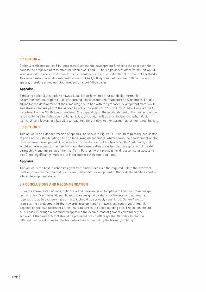
3.5 OPTION 4
Option 4 replicates option 3 but proposes to extend the development further to the east such that it
bounds the proposed access street between plot B and C. The single aspect office/retail unit would
wrap around the corner and allow for active frontage uses at the end of the North South Link Road 2.
This would extend available retail/office footprint to 1,500 sqm and add another 100 car parking
spaces, therefore providing total numbers of about 1000 spaces.
Appraisal
Similar to option 3 this option shows a superior performance in urban design terms. It
accommodates the required 1000 car parking spaces within the multi storey development. Equally it
allows for the development of the remaining site in line with the proposed development framework
and already realises part of the aspired frontage towards North South Link Road 2. However the full
installment of the North South Link Road 2 is depending on the establishment of the link across the
listed building site. If this can not be achieved, this option will be less desirable in urban design
terms, since it leaves less flexibility to react to different development scenarios for the remaining site.
3.6 OPTION 5
This option is an extended version of option 4, as shown in Figure 11. It would require the acquisition
of parts of the listed building site or a land-swap arrangement, which allows the development of plot
B as coherent development. This includes the development of the North South Road Link 2, and
would achieve access to the riverfront and therefore realise the urban design aspiration of greater
permeability and linking up of the riverfront. Furthermore it provides for direct vehicular access to
plot C and significantly improves its independent development options.
Appraisal
This option is the best in urban design terms, since it achieves the required link to the riverfront.
Further it creates the precondition for an independent development of the bridgehead site as part of
a later development stage.
3.7 CONCLUSIONS AND RECOMMENDATION
From the above tested options, option 3, 4 and 5 are superior to options 2 and 1 in urban design
terms. Option 5 achieves all significant urban design aspirations for the site, and although it
requires the additional purchase of land, it should be seriously considered. Option 4 would
progress the development further towards development framework aspiration, yet ultimately
depends on the establishment of the link road across the listed building site. This option should
be pursued if through a coordinated approach the desired road alignment can similarly be
achieved. Otherwise option 3 should be preferred, which offers greater flexibility to react to
different design solutions for the bridgehead site surrounding the brewery building.
B22
42
PrincesRoad
Public art
Pedestrian + c
ycle path
River trail
West End Road
River Orwell
N
Option 4 + 5
Pedestrian + cycle path
River trail
10m50m
10m10m
10m10m
Club
Firestation
3750 sqm
~ 157 spaces
Development
area
663 sqm
Development area
4775 sqm
4983 sqm
~ 207 spaces
Layout for upper floors
Office/retail 575 sqm
Groundfloor / 1st floor ~ 100 parking spaces
Office/retail 625 sqm
Figure B11: Option 4 and 5
1 7 3 5 U R B A N D E S I G N B R I E F W E S T E N D R O A D C A R P A R K B23

App
endi
x C
Cor
rido
r Im
prov
emen
t In
itia
tive
(To
Follo
w)