bonner soil & water conservation district
TRANSCRIPT

BONNER SOIL & WATER CONSERVATION DISTRICT
1224 Washington Avenue, Suite 101
Sandpoint, Idaho 83864
FIVE-YEAR RESOURCE CONSERVATION
BUSINESS PLAN
Updated March 2017

2

3
Executive Summary The Bonner Soil and Water Conservation District is one of 50 Conservation Districts in Idaho. Idaho Soil and Water Conservation Districts are political subdivisions of state government but are not state agencies. Conservation Districts are charged with carrying out a program for the conservation, use and development of soil, water, and other natural resources. Conservation Districts are the primary entities to provide assistance to private landowners and land users in the conservation, sustainment, improvement and enhancement of Idaho’s natural resources. They are catalysts for coordinating and implementing conservation programs, channeling expertise from all levels of government into action at the local level. Programs are non-regulatory and include science-based technical assistance, incentive-based financial programs, and informational and educational programs at the local level. Both by legislation and by agreement the USDA Natural Resources Conservation Service provides technical assistance to landowners and land users through Conservation Districts. Each Conservation District in Idaho has signed a Mutual Agreement with the Secretary of Agriculture and the Governor of Idaho that establishes a framework for cooperation. This Annual Plan/ Five-Year Resource Conservation Business Plan was developed not only to guide the Conservation District, but also to encourage cooperation among landowners, government agencies, private organizations, and elected officials. Through knowledge and cooperation, all concerned can ensure a sustainable natural resource base for present and future generations in the Bonner Soil and Water Conservation District. This document identifies the resource needs in the Conservation District and presents a resource conservation action plan for meeting these needs.

4
Certificate of Adoption The Board of elected supervisors of the Bonner Soil and Water Conservation District do hereby approve the following document known as the Five Year Resource Conservation Business Plan as of March 7, 2017. This Plan will be updated annually and/or amended, as necessary. As evidence of our adoption and final approval, we do hereby affix our signatures to this document. _____________________Chairman Alice M. Wallace _____________________Vice Chairman Dale Van Stone _____________________Secretary/Treasurer Cassie Tauber _____________________ Member Herman B. Collins _____________________ Member Harry Menser

5
5-Year Resource Conservation Plan Business Plan (2017 to 2022) BONNER Soil & Water Conservation District For More Information Contact: Linda O’Hare, 208-263-5310,
[email protected] Organization of the Bonner Soil & Water Conservation District A political subdivision of the State of Idaho – authorities, power and structure contained in Soil Conservation District Law, Title 22, Chapter 27, Idaho Code Organized on July 15, 1946, to provide voluntary land and water conservation, technical and financial
assistance to landowners and uses with the Bonner SWCD boundary First District board members were M.A. Roberts, Chairman, Blanchard; Glen Reed, Vice Chairman,
Sagle; H.L. King, Priest River; Sloan Crawford, Sandpoint; A.M. Derr, Sagle. Ed Nurmi was selected to fill the Soil Conservation Service position during this time.
Early district reports show an objective of the District was to aid the livestock grower in classifying the range land and conditions to select the most profitable grazing system. Other high priorities for the area were proper fertilization, residue management, woodland management, and proper hay seedings. Some areas in Bonner County needed education on draining practices and others were in need of help with irrigation. This shows the diversity of the District.
Mission of the Bonner Soil & Water Conservation District To take available technical, financial and educational resources whatever their source and focus and
coordinate them to meet the needs of the landowners. Who We Serve & Why We serve the people and natural resources in Bonner County for the purpose of conserving the natural
resources for the beneficial and sustainable use by all. Values of the Bonner Soil & Water Conservation District Sustainable use of natural resources Support for agriculture activity that uses sustainable, economic feasible practices Value and respect for the Idaho Conservation Partnership Conservation education for adults and youth Coordination among agencies, municipalities, and people ___________________________________________________________________________ Natural Resource Priorities and Goals: Information and Education/District Operations Water Resources – Water Quality and Riparian Buffers Timber and Woodland Fish, Wildlife, and Recreation Pasture and Hayland

6
Natural Resource Priorities and Goals continued:
1. Public Outreach By 2020 prepare information and hold workshops to educate the public on North Idaho Water
Adjudication Continue to advance Lake Assist and Stormwater and Erosion Education Program (SEEP) and put
updated information on the Lake Assist website Annually conduct youth environmental education programs and increase participation in the Idaho
State Forestry Contest and the Pend Oreille Water Festival Annually sponsor a booth at an event, Bonner County Fair, Earth Day, or Arbor Day Coordinate with USDA in developing noxious weed education strategy for north Idaho Support efforts of Ag Tourism Provide current information to constituents through the district semi-annual newsletter
2. Water Quality
Attend Pend Oreille Lake Nearshore, Pack River Watershed Council, Clark Fork WAG, Priest River
WAG, and Cococalla Lake Association meetings Provide stormwater information to landowners and municipalities in Bonner county through
newsletters and Lake Assist outreach Continue to contact landowners on Lake Pend Oreille, Priest Lake, and on the Pend Oreille River to
inform them of the information available on the Lake Assist website, as well as distribute Lake Assist books.
Work with developers & landscapers to maintain shoreline and streambank vegetation & stabilization through Lake Assist and Stormwater Erosion & Education Program (S.E.E.P.)
Maintain and increase Kootenai-Ponderay Willow Nursery for further stabilization projects Administer ISDA grant for three boat inspection stations in Bonner county to both educate boat
owners as well as to prevent mussels from getting established in Bonner County Work with partners on solution to Asian Clams in Ellisport Bay
3. Timber and Woodland
Conduct an annual conservation tree sale program to encourage constituents to develop
conservation and farmstead wind breaks. Coordinate with local agencies and land owners on fire prevention and healthy forest maintenance Develop website with fire prevention information, as well as evacuation procedures when wildfire
nears 4. Fish, Wildlife and Recreation
Work with Aquatic Invasive Species local managers to control & evaluate aquatic invasive plants.
Assist Bonner County in outreach education efforts to prevent new invaders, ie mussels and Asian Clam.
Work with marina and boat owners and Bonner County on spill prevention and cleanup efforts, as well as education
Partner with F&G, US FWS, Bonner County, and IDL on projects protecting or improving fish passage and fish & wildlife habitat
5. Pasture and Hayland
Work with Bonner County Weed Supervisor to implement noxious weed management practices Direct landowners to NRCS for information and technical assistance on rotational intensive grazing Purchase no-till drill for rental to local farmers

7
Critical Geographic Areas: (attached map)
Critical areas for natural resource concerns in Bonner County include the shorelines of the major waterways which include three lakes, Pend Oreille, Priest, and Cocolalla, and three rivers, Clark Fork River leading into Lake Pend Oreille from Montana, Pend Oreille River leading out of Lake Pend Oreille to Washington, and the Pack River which leads into Lake Pend Oreille from the north. As Northern Idaho continues to grow, pressures on the natural resources of the area increase. Much of the new development is occurring along waterfront areas, adding pressure to the sensitive riparian areas and increasing the direct impact to lake water quality. Some issues that accompany shoreline development include habitat fragmentation, decrease in riparian buffers, wastewater disposal, increased stormwater runoff volume and velocity, and improper planning and/or installation of erosion and sediment control techniques. These can result in degradation of terrestrial and aquatic habitat, increased erosion, and increased pollutant delivery to waterways that can impact drinking water and increase the cost of community infrastructure (water treatment needs, clogged drainage ways, etc).
Priest Lake
Sandpoint
Pend Oreille River
Pack River
Lake Pend Oreille
Clark Fork River Cocolalla Lake
8
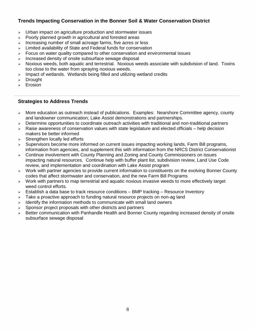
Trends Impacting Conservation in the Bonner Soil & Water Conservation District Urban impact on agriculture production and stormwater issues Poorly planned growth in agricultural and forested areas Increasing number of small acreage farms, five acres or less Limited availability of State and Federal funds for conservation Focus on water quality compared to other conservation and environmental issues Increased density of onsite subsurface sewage disposal Noxious weeds, both aquatic and terrestrial. Noxious weeds associate with subdivision of land. Toxins
too close to the water from spraying noxious weeds. Impact of wetlands. Wetlands being filled and utilizing wetland credits Drought Erosion
Strategies to Address Trends More education as outreach instead of publications. Examples: Nearshore Committee agency, county
and landowner communication; Lake Assist demonstrations and partnerships. Determine opportunities to coordinate outreach activities with traditional and non-traditional partners Raise awareness of conservation values with state legislature and elected officials – help decision
makers be better informed Strengthen locally led efforts Supervisors become more informed on current issues impacting working lands, Farm Bill programs,
information from agencies, and supplement this with information from the NRCS District Conservationist Continue involvement with County Planning and Zoning and County Commissioners on issues
impacting natural resources. Continue help with buffer plant list, subdivision review, Land Use Code review, and implementation and coordination with Lake Assist program
Work with partner agencies to provide current information to constituents on the evolving Bonner County codes that affect stormwater and conservation, and the new Farm Bill Programs
Work with partners to map terrestrial and aquatic noxious invasive weeds to more effectively target weed control efforts.
Establish a data base to track resource conditions – BMP tracking – Resource Inventory Take a proactive approach to funding natural resource projects on non-ag land Identify the information methods to communicate with small land owners Sponsor project proposals with other districts and partners Better communication with Panhandle Health and Bonner County regarding increased density of onsite
subsurface sewage disposal

9
Annual Budget Needs
Bonner Soil & Water Cons. District Budget Overview: FY2015 Budget
July 2016 - June 2017
Income County Appropriations 8,500 State Appropriation 8500 + 12,400 + 800 21,720 Grant Admin 32,017 Grant Funding 288,245 Audit Fee 133 Interest 640 AIS Sticker Sales 57,000 Tree Sales 28,240 Willow Nursery Sales 1,950 Fund Balance Carryover 6,551 GROSS INCOME 444,996
Expense Payroll – 1.5 people 61,220 Audit 3,160 Donations 125 Dues 2,625 Equipment/Repair 100 Grant Funds Expended 288,245 AIS Sticker Sales 54,000 Tree Expense 22,650 Liability Insurance 1,122 Medical Insurance 3,864 Office Supplies 350 Petty Cash 100 Postage 270 Public Outreach 400 Storage Facility 720 Subscriptions 45 Travel 4,700 District Employee 1000 Supervisors 3700 Willow Nursery 1,200 Uncategorized 100 NET INCOME GROSS EXPENSE 444,996

10
Key Decision Makers Citizens in Conservation District County Commissioners: Glen Bailey, Jeff Connolly, Dan McDonald County Officials: Milton Ollerton, Planning and Zoning Don Hutson, Bonner County Public Works Chase Youngdahl, County Weeds Supervisor City of Sandpoint Officials: Mayor Shelby Rognstad Ryan Luttman, Director of Public Works Legislators: Senator Shawn Keough Rep. Sage Dixon Rep. Heather Scott Conservation District Supervisors Alice M. Wallace Dale Van Stone Cassie Tauber Herman B. Collins Harry Menser Greater Sandpoint Chamber of Commerce: Kate McAlister, Exec. Director Priest River Chamber of Commerce: Jim Martin, Priest River Mayor Priest Lake Chamber of Commerce: Craig Hill Pend Oreille Basin Commission: Ford Elsaesser, Chairman, and Molly McCahon, Coordinator Physical Characteristics of the District Bonner County is in the northern Idaho Panhandle. The total area is 1920 square miles, with 9.6% being surface water, the most of any Idaho county. Bonner County’s Lake Pend Oreille is Idaho’s largest natural lake, covering 90,000 acres and reaching depths of about 1,200 feet. Priest Lake and Upper Priest Lake in the northwestern portion of the County are known for their exceptionally high water quality and natural aesthetics. Lower Priest Lake is the third largest natural lake entirely within Idaho. The land area consists of rugged, forested mountainous or hilly terrain and of comparatively narrow valleys that open to the south – 84% of the land is forested. The glacially sculptured Selkirk Mountains are in the northern and western parts of the area, and the Cabinet Mountains are in the eastern part. Most prominent of the valleys is the Selle Lowland, which is an extension of the Purcell Trench north of Sandpoint. Other valleys include the Clark Fork Valley in the eastern part of the area, the Priest River Valley in the northwestern part, and Blanchard, Hoodoo, and Cocolalla Valleys in the southern part. Sandpoint is the county seat of Bonner County, and has a population of 7658. Its elevation at the north end of Lake Pend Oreille is about 2,100 feet. The highest elevations are in the northern part of the county where some mountain peaks are more than 7,000 feet high. Soil, water, and timber are the most important natural resources in the area. Livestock, crops, and timber are marketable products derived from the soil. Millions of board feet of lumber are cut annually from ponderosa pine, lodgepole pine, western red cedar, western hemlock, and spruce. Boards, poles, posts, shingles, and shakes are among the main products of the forest industry, while small logs and chips are used in the pulp industry. Some local timber is also used for veneer.

11
The abundant water resources include Pend Oreille and Priest Lakes and the three major rivers are the Clark Fork, Pack, and Priest Rivers. Overall, water quality in the area is considered to be excellent. Large quantities of ground water and the principal recharge area for the Rathdrum aquifer are in the southern part of the County. Wetlands are scattered throughout the area, but the major areas are adjacent to the Pend Oreille and Pack Rivers. The boundaries of the District coincide with the boundaries of Bonner County, Idaho. The acreage of the District is as follows: Land Ownership Acres Federal Land 492,593 BLM 11,162 Nat’l Forests 472,575 Other 8,856 State Land 170,053 Endowment Land 167,640 Fish & Game 1,415 Parks & Recreation 803 University of Idaho Land 195 Private Land 440,780 County Land 4,521 Municipal Land 4,117 Total Land Acreage 1,112,064 The above acreage figures were provided by the Idaho Department of Commerce website. http://www.idoc.state.id.us/idcomm/profiles/pdfs/Bonner.pdf *An interesting note: Total water acreage exceeds total croplands. **Nearly one quarter of all Idaho surface water lies in Bonner County

12

13

14
District Resources Land Use* Acres Urban Land 3,400 Cropland 44,800 Pastureland 28,000 Forest 1,034,200 Water 110,700 Wetland 1,200
Total 1,222,300
*USGS land use/cover classification system. The water category and the rounding and estimating of satellite based data usually results in slightly higher totals for land use. The above data obtained from the Idaho Department of Commerce website and modified with 1997 National Resources Inventory data. http://www.idoc.state.id.us/idcomm/profiles/pdfs/Bonner.pdf
Soil Resources The greater part of the county is mountainous with narrow flat bottom stream valleys. Purcell Trench, a long comparatively narrow valley passes through the center of the county from North to South. The trench varies from 1 ½ miles wide at the north end near Elmira, to more than 8 miles at the north end of Lake Pend Oreille. Here the trench divides. The deepest branch is occupied by Lake Pend Oreille, and the other branch comprises Cocolalla Valley. East of the trench are the Cabinet and Coeur d’Alene Mountains rising to 7,000 feet. They are separated by the Clark Fork River entering from the east. West of the trench are the high Selkirk Mountains rising to elevations exceeding 7,500 feet. Lake Pend Oreille River, which forms the outlet of Lake Pend Oreille, cuts across the Selkirk Mountains entering Washington to the west before turning north to the Columbia River in Canada. The larger tributaries forming the major agricultural valleys are Priest River, Pack River; Sand, Cocolalla, and Hoodoo Creeks. The larger valleys are broken by scattered, poorly defined moraines and outcrops of bedrock. Outwash plains and terraces lie at various elevations. Terraces reach a maximum elevation of 2,600 feet above sea level. Lake Pend Oreille was stabilized at 2,062.5 feet by construction of Albeni Falls Dam in 1954. Sandpoint, situated on a delta or lake terrace at the north end of the lake is 2,100 feet in altitude. Hoodoo Valley in the southwest portion of the county is a southward pre-glacial extension of Priest River Valley. West of the Hoodoo lies Blanchard Valley, extending from north to south along the Idaho-Washington border. All of the agricultural soils in the District are of glacial origin. The mountains have residual soils from granite. Most of the agricultural soils are cutover type and are low in organic matter. The 1981 Bonner County Soil Survey breaks soils into the following broad map unit descriptions and percentages of land in the county.

15
Moderately steep to very steep, well drained soils on mountains 35% Rolling to very steep, well drained soils on foothills and mountains 35% Level to hilly, well drained soils on glacial moraines and terraces 15% Level to hilly, poorly drained to excessively drained soils on alluvial fans, terraces, and dunes 9% Level to nearly level, poorly drained to very poorly drained soils on low stream terraces, flood plains, and bottomlands 3%
Climatic conditions The Bonner Soil Conservation District has a modified continental climate. Summers are comparatively short and cool, and extremes of cold winter temperatures are of short duration. Comparatively little rain falls during the summer. July and August are the driest months of the year. The heaviest precipitation occurs from November to April, with much of the precipitation in the form of snow. The following table shows the climate statistics from two cities in the county. Lowest Aver. Highest Aver. Mean Annual Daily Min. Daily Max. Precip. Snowfall Location Elevation (ft.) Temp. Temp. inches inches Sandpoint 2,085 19° 83° 28 64 Priest River 2,077 18.8° 82.6° 33.1 94.3 Climatic data obtained from Idaho Department of Commerce website. http://www.idoc.state.id.us/idcomm/profiles/index.html Due to the varied topography – as low as 2,000 feet to as high as 7,000 feet - weather patterns vary in temperature and precipitation. Economic Condition and Outlook for the District Population: (In 2015 Bonner County population decreased to 41,673)
1980 1990 2002 2010 2015 Sandpoint 4,460 5,203 7,167 8,159 7,658 Bonner County 24,163 26,622 37,479 41,782 41,673

16
County Labor Force Data
Non Farm Employment (2000)
Total Non Farm Employment 11,856 Food Products 283 Lumber & Wood Products 961 Chemicals * Metals 71 Machinery (exc. elect) 77 Electronics & Elec. Equip. 131 Other Manufacturing 284 Construction 816 Mining 75 Trans/Comm/Util 470 Wholesale and Retail Trade 3,505 Finance, Insur, & Real Est 421 Services & Misc. 2,505 Government 2,257 * Indicates no employment or suppressed data
Civilian Labor Force 2000 2010 2015 Total Labor Force 17,396 20,643 20,643 Total Employment 15,836 18,503 Total Unemployed 1,560 2,118 Percent Unemployed 9 10 5% Farm Employment 295
Agricultural Economy
Farms, Cropland, & Livestock 1987 1992 1997 2007 2012 Total number, All Farms 516 476 501 687 686 Total Acres in Farms 136,833 150,021 98,662 94,380 80,623 Avg. Farm Size (acres) 265 315 197 137 118 Total Farms in Crops 446 414 439 Total Acres in Crops 46,034 42,641 36,975 32.4% Cattle and Calves Inventory 14,129 13,828 9,210 4,336 Number of Irrigated Farms 85 81 86 Number of Irrigated Acres 4,984 2,617 1,962
Farms by Size (Acres) 1987 1992 1997 2012 Under 10 26 34 37 85 10 to 49 121 118 180 262 50 to 179 190 157 144 176 180 to 499 125 122 96 136 500 to 999 33 27 26 15 1,000 & over 21 18 18 12

17
Principal Occupation of Farm Operators 1987 1992 1997 2012 Farming 245 232 217 294 Other 271 244 284 392 The above charts were obtained from the Idaho Department of Commerce website. http://www.idoc.state.id.us/idcomm/profiles/pdfs/Bonner.pdf and 2012 information from NASS. In 2012 the average age of principal farm operator is 60.2 years.
Wage statistics from http://www.indicatorsnorthwest.org/DrawRegion.aspx?PageID=13&RegionID=16009 show 2011 average annual wage in Bonner County as $33,238, the mean household income at $42,109, and December 2011 unemployment at 9.6%.
Forestry is the top revenue producing industry of the district. The primary agriculture income is received from hay, pasture, and cattle. There are no large dairies in Bonner County, but there are a number of small all natural organic dairies with diversified livestock. Increased demand for land to provide lakeshore home sites, summer home cabins, resorts, and recreation facilities is expected to continue in coming years. Several farms have already changed to suburban home development and recreation enterprises. Development of winter sports areas will provide year round recreation and create greater demand for land to be used for home site development and recreation. Many public and private campgrounds, resorts, and motels, provide excellent facilities for all types of water sports, picnicking, boating, and fishing. Overall trends and conditions in water quality Less impact from timber and agriculture are expected, as the Forest Practices Act is implemented and there is less agricultural activity in the county. Conservation needs are increased education and implementation of the Forest Practices Act. Agriculture producers need to be involved in the initial phases of water quality improvement plans. Their involvement is needed in development of agricultural BMPs. There is also a need for development of Best Management Practices for wetland grazing. More problems are expected from cultural eutrophication, recreation, urban runoff, building and development. Conservation needs include education and encouragement of erosion control methods and public awareness of how their activities may affect water quality. Conservation needs to achieve desired surface water quality: • Proper design, installation, and maintenance of all roads, road ditches, and culverts • Proper sites for individual septic treatment facilities • Technical assistance to farmers because farmland field ditches can deliver sediments, nutrients, and floodwaters at an increased rate to streams, rivers, and lakes • Technical assistance to farmers for feedlot runoff from confined animal feeding operations • Technical assistance for streambank erosion • Educational programs for proper farmland and residential use of organic and inorganic fertilizers

18
Department of Environment Quality Integrated Reports & TMDL Information:

19

20
Water Quality Component The summaries below were taken from DEQ website: http://www.deq.idaho.gov/water-quality/surface-water/tmdls/table-of-sbas-tmdls/
Clark Fork River (Lower) Subbasin
Subbasin at a Glance
Hydrologic Unit Code 17010213
Size 247 square miles (158,080 acres)
Water Bodies with EPA-
Approved TMDLs
(Category 4a)
Cascade Creek, Clark Fork River, Dry Creek, East Fork Creek, Johnson Creek,
Lightning Creek and tributaries, Mosquito Creek, Rattle Creek, Savage Creek,
Twin Creek, Wellington Creek
Beneficial Uses Affected Cold water aquatic life, salmonid spawning, primary and secondary contact recreation, domestic water supply
Major Land Uses Forestry, agriculture, rural residential, recreation
Date Approved by EPA October 2007
EPA Approval Letter
Dates Clark Fork-Pend Orielle TMDL Approved by
EPA
April 2001
EPA Approval Letter
September 2000
EPA Approval Letter
Subbasin Characteristics
Primarily located in Montana, the 320-mile long Clark Fork River flows from near Butte, Montana, to Lake Pend Oreille in Idaho. The Clark Fork River drains approximately 22,000 square miles in western Montana and northern Idaho, 247 square miles of which comprise the Lower Clark Fork subbasin in northern Idaho. The river drains into the 95,000-acre Lake Pend Oreille, and as the lake’s largest tributary, the Clark Fork River contributes approximately 92% of the annual inflow to the lake and most of the annual suspended sediment load.

21
2007 Subbasin Assessment and TMDL
This document addresses the lower-most 247 square miles of the subbasin located in north Idaho. The Lower Clark Fork
subbasin includes 180 miles of perennial streams. The river itself flows from east to west. With approximately 75% of the
subbasin in public ownership, there is a diversity of recreational opportunities and wildlife. The river’s main tributary,
Lightning Creek, harbors a regionally significant Bull Trout population and supports many other native fish. Located just
downstream from the Montana/Idaho border 10 miles before the river enters Lake Pend Oreille is AVISTA’s Cabinet Gorge
Dam. The Cabinet Gorge Reservoir has a storage capacity of 105,000 acre-feet at full pool.
Metals and total dissolved gas pollution are the pollutants of concern in the main stem Clark Fork River. Intensive mining
around the headwaters of the Clark Fork River in Montana left residues of heavy metals behind, which still pose a risk to
water quality throughout the basin. Total dissolved gas supersaturation caused by the entrainment of gas in the water
when spill occurs at a hydroelectric facility can remain high for significant distances downstream from the facility.
Cabinet Gorge Dam has a capacity of approximately 36,000 cubic feet per second. When river flows exceed this capacity,
excess flow spills. Entrained gases from these spills can remain in the water column into Lake Pend Oreille and the Pend
Oreille River.
Temperature is identified as a pollutant in the lower Clark Fork River below the Idaho/Montana border. However, the
lower Clark Fork River on the Montana side of the border has not been found to violate Montana water quality standards
for temperature.
Sediment and temperature are the pollutants of concern in the tributaries to the lower Clark Fork River. Thick glacial
outwash sediments in steep drainages combined with timber harvest and road construction have created potential
sediment problems in several of the tributaries to the Clark Fork River. Temperatures exceed water quality standards for
salmonid spawning throughout the subbasin. Fire and historic timber harvest have created a more open canopy and
related stream warming compared to background conditions.
TMDLs were developed for each stream determined to not fully support beneficial uses in accordance with state of Idaho
water quality standards. The TMDLs included in this document address in-stream sediment, metal, and temperature
reduction goals to maintain or restore cold water aquatic life and salmonid spawning in the tributaries. The TMDLs help
quantify needed improvements and target management actions to address water quality improvement measures and
timelines.
2007 TMDL: Streams and Pollutants for Which TMDLs Were Developed Clark Fork River (main stem in Idaho) Metals, total dissolved gas Cascade Creek Temperature Dry Creek Temperature Mosquito Creek Temperature Twin Creek Sediment, Temperature East Fork Creek Sediment, Temperature Johnson Creek Sediment, Temperature Lightning Creek Sediment, Temperature Rattle Creek Sediment, Temperature Savage Creek Sediment, temperature Wellington Creek Sediment, Temperature

22
2001 Clark Fork–Pend Oreille Watershed Assessment and TMDL
This watershed spans two subbasins and is summarized in the table below.
Hydrologic Unit Codes
17010213 (Lower Clark Fork Subbasin) 17010214 (Pend Oreille Lake Subbasin)
Size 25,000 square miles (16,000,000 acres) in Idaho and Montana
Beneficial Uses Affected
Cold water aquatic life, salmonid spawning, warm water biota, primary contact recreation, secondary contact recreation, agricultural water supply, industrial water
supply, domestic water supply
Major Land Uses Agriculture, grazing, roads, hydropower, mining, timber harvest, urban, recreation
* These water bodies are located in the Lower Clark Fork subbasin (hydrologic unit code 17010213). They are analyzed in the 2007 Clark
Fork/Pend Oreille subbasin assessment document and are assigned TMDLs in the Lower Clark Fork River subbasin assessment and total maximum
daily loads discussed on this page.
The Clark Fork-Pend Oreille watershed lies in western Montana, northern Idaho, and northeastern Washington. The
watershed is the source of the water that enters and leaves Lake Pend Oreille, the largest and deepest natural lake in
Idaho. Inflow and outflow of the lake are regulated by hydroelectric facilities.
The Pend Oreille portion of this subbasin assessment examined 11 streams, 1 major river, and 2 lakes. Of the 11 streams,
5 were water quality impaired and required load allocations, primarily for sediment. Both Lake Pend Oreille and the Pend
Oreille River were found to fully support their beneficial uses and were recommended for delisting.
The Clark Fork portion of this subbasin assessment was tabled until its scheduled assessment date in 2004. Insufficient
time to complete the assessment and the prospect of more data available at that time drove this decision.
2001 TMDL: Streams and Pollutants for Which TMDLs Were Developed
Cocolalla Creek (lower) Sediment Cocolalla Creek (upper) Sediment North Fork Grouse Creek Sediment Hoodoo Creek Sediment Pack River Sediment Cocolalla Lake Phosphorus

23
Pend Oreille Lake Subbasin
Subbasin at a Glance
Hydrologic Unit Code 17010214
Size 70 square miles (44,740 acres)
Water Bodies with EPA-
Approved TMDLs
(Category 4a)
Berry Creek, Caribou Creek, Cedar Creek, Cheer Creek, Chloride Creek,
Chloride Gulch, Cocolalla Creek, Cocolalla Lake, Colburn Creek, Fish Creek,
Gold Creek, Granite Creek, Grouse Creek, Hellroaring Creek, Hoodoo Creek,
Jeru Creek, Little Sand Creek, McCormick Creek, North Fork Grouse Creek,
Pend Oreille Lake, Rapid Lightning Creek, Sand Creek, Schweitzer Creek,
Spring Jack Creek, Swede Creek, Trestle Creek, Trout Creek, Upper and
Lower Pack River, West and North Gold Creeks
Beneficial Uses Affected Water supply, recreation, salmonid spawning, cold water aquatic life, wildlife habitat, aesthetics
Major Land Uses Forestry, urban, shrubland, wetland, pasture/cropland
Date Approved by EPA October 2002
EPA Approval Letter
Dates Clark Fork-Pend Oreille TMDL Approved by
EPA
April 2001
EPA Approval Letter
September 2000
EPA Approval Letter
Date Temperature TMDL Addendum Approved by
EPA
April 2008 EPA Approval Letter
Date Sediment TMDL Addendum Approved by
EPA
January 2008 EPA Approval Letter
Date Pack River Nutrients TMDL Addendum Approved by EPA
December 2008 EPA Approval Letter

24
Subbasin Characteristics
Lake Pend Oreille is part of the Clark Fork-Pend Oreille Basin, which lies in western Montana, northern Idaho, and
northeastern Washington. The Clark Fork River begins near Butte, Montana, and drains an extensive area of western
Montana before entering Lake Pend Oreille in Idaho at the lake's northeast corner. The lake is the source of the Pend
Oreille River in northeastern Washington, which ultimately drains to the Columbia River.
2002 Subbasin Assessment and TMDL
Lake Pend Oreille was placed on Idaho's 1994 §303(d) list as a "threatened" water body and retained on the 1996 and 1998
lists. Because of this listing, DEQ prepared a problem assessment for the lake, which recommended developing a TMDL for
the nearshore waters of the lake to mitigate increasing eutrophication along the shoreline. This TMDL addresses this
recommendation.
2002 TMDL: Streams and Pollutant for Which TMDLs Were Developed Nearshore waters of Lake Pend Oreille Total phosphorus
2007 Clark Fork - Pend Oreille Addendum: Nutrients
This document addresses streams in the Pack River watershed that have been placed on Idaho’s §303(d) list. This
document only addresses nutrient impairments for the Pack River watershed, which is located in the Pend Oreille Lake
subbasin in northern Idaho. The Pack River watershed encompasses approximately 185,600 acres.
The Pack River and its tributaries have been identified as impaired due to causes unknown. Stressor identification reports
were completed for all assessment units impaired by causes unknown, and potential stressors/pollutants have been
identified for each assessment unit. For each assessment unit the following stressors/pollutants were evaluated as
possible contributors to impairment: low nutrients, altered flow regime, increased sediment, reduction in riparian
habitat, increased metals concentrations, increased nutrients, and misuse of sampling protocol. Stressor identification
reports shows sediment, temperature, and nutrients as the likely pollutants. During this addendum effort, DEQ developed
nutrient TMDLs for four water bodies (ten assessment units).
2007 Addendum (Nutrients): Streams and Pollutants for Which TMDLs Were Developed Sand Creek Nutrients Colburn Creek Nutrients Trout Creek Nutrients Pack River Nutrients
2007 Clark Fork - Pend Oreille Addendum: Temperature
This addendum addresses 19 water bodies in the Pend Oreille Lake subbasin placed on Idaho’s §303(d) list for temperature
impairment. Effective shade targets were established for these streams based on the concept of maximum shading under
potential natural vegetation resulting in natural background temperature levels. Shade targets were derived from
effective shade curves developed for similar vegetation types in the Northwest. Existing shade was determined from aerial
photo interpretation field verified with a Solar Pathfinder.

25
Most streams examined in this TMDL had excess solar loads. Notably, the Pack River and several of its larger tributaries
(Grouse Creek, Rapid Lightning Creek, McCormick Creek, and Hellroaring Creek) had high excess loads with reductions of
30% to 90% necessary to achieve target levels. Hoodoo Creek and upper Cocolalla Creek also had high excess loads;
however, their necessary percent reductions were generally less than 30%. North Fork Grouse Creek and Granite Creek are
recommended for delisting from the §303(d) list for temperature based on analysis performed while developing these
TMDLs.
2007 Addendum (Temperature): Streams and Pollutants for Which TMDLs Were Developed Hoodoo Creek Temperature Cocolalla Creek Temperature Fish Creek Temperature Granite Creek Temperature Grouse Creek Temperature Pack River Temperature Trestle Creek Temperature Cedar Creek Temperature South Gold Creek Temperature West Gold Creek Temperature Chloride Gulch Creek Temperature Hellroaring Creek Temperature Jeru Creek Temperature McCormick Creek Temperature North Fork Grouse Creek Temperature North Gold Creek Temperature Rapid Lightning Creek Temperature West Sand Creek Temperature Trout Creek Temperature
2007 Clark Fork - Pend Oreille Addendum: Sediment
The overall purpose of this addendum is to characterize and document sediment pollutant loads for a select group of
tributaries in the Pend Oreille Lake subbasin. This report addresses five watersheds in the Pend Oreille Subbasin that
include 11 assessment units identified in Idaho’s 2002 Integrated Report as water quality limited by an unknown pollutant
or excess sediment. These 6th-order watersheds are Upper Pack Creek, Gold Creek, North Gold Creek, Rapid Lightning
Creek, and Sand Creek. The five watersheds addressed in this report comprise 121,927 acres, or approximately 190 square
miles of the Pend Oreille Lake subbasin, and include assessment units encompassing the Pack River, McCormick Creek,
Hellroaring Creek, Sand Creek, Schweitzer Creek, Gold Creek, Rapid Lightning Creek, and North Gold Creek. Sediment
TMDLs were established for 14 assessment units to reduce nonpoint source sediment pollutant loads in the subbasin.
2007 Addendum (Sediment): Streams and Pollutants for Which TMDLs Were Developed Upper Pack River Sediment Hellroaring Creek Sediment Sand Creek Sediment Jack Creek Sediment Swede Creek Sediment Schweitzer Creek Sediment Little Sand Creek Sediment Gold Creek Sediment North Gold Creek Sediment

26
Priest River Subbasin
Subbasin at a Glance
Hydrologic Unit Code 17010215
Size 981 square miles (627,840 acres)
Water Bodies with EPA-
Approved TMDLs
(Category 4a)
Binarch Creek, East River, Kalispell Creek, Lower Priest River, Lower West
Branch Priest River, Middle Fork East River, North Fork East River, Reeder
Creek
Beneficial Uses Affected Cold water aquatic life, salmonid spawning
Major Land Uses Forestry, agriculture, rural recreation
Date Approved by EPA March 2002 EPA Approval Letter
Date Addendum Approved by EPA
June 2003
Subbasin Characteristics
The Priest River subbasin falls primarily within the northwest corner of the Idaho Panhandle in Bonner and Boundary
Counties. The headwaters of upper Priest River originate within the Nelson Mountain Range of British Columbia;
headwaters of major streams on the western side of the basin originate in northeast Washington.
2001 Subbasin Assessment and TMDL
In 1994 and again in 1996, ten segments within the Priest River subbasin were classified as water quality limited under
§303(d) of the Clean Water Act. All Priest River subbasin §303(d)-listed streams are listed for sediment (except Lower
West Branch Priest River, which had no listed pollutants of concern, but sediment is implied). Nutrients are a listed
pollutant for Tango Creek, and dissolved oxygen, temperature, and flow alteration are listed for East River. Habitat
alteration is listed for Trapper Creek and Two Mouth Creek.
While habitat alteration and flow alteration may adversely affect beneficial uses, they are not pollutants as defined under
§303(d) of the Clean Water Act; therefore, TMDLs were not developed to address habitat and flow alteration as
pollutants.

27
2001 TMDL: Streams and Pollutants for Which TMDLs Were Developed Kalispell Creek Sediment Lower West Branch Priest River Sediment
2003 Addendum
In March 2002, EPA approved sediment TMDLs for two water bodies: Kalispell Creek and Lower West Branch Priest River.
Action on other segments was delayed at DEQ's request to allow for further data collection and analysis. An addendum
addressing these other water bodies was submitted to EPA for review in February 2003 and approved in June 2003.
2003 Addendum: Streams and Pollutants for Which TMDLs Were Developed Reeder Creek Sediment Binarch Creek Sediment East River Sediment, Temperature Middle Fork East River Temperature North Fork East River Temperature Lower Priest River Sediment

FY2018 (7/1/2017 – 6/30/2018) Annual Plan of Work
Bonner Soil & Water Conservation District
Conservation District Priority Number 1: District Operations/Information & Education
Objective: Conduct operations in accordance with soil conservation district law for effective local natural resource conservation Goal(s): Administer county, state, federal and grant funds efficiently for effective conservation Increase public awareness of the District and provide strong leadership in adult & youth conservation information programs
Bonner Soil & Water Conservation District assisting land managers with their conservation choices
Actions Target Date
Individual(s) Responsible
•Maintain accurate financial records, conduct annual audit, meet annually with County Commissioners & keep them informed, submit budget rpts to the legislature.
Monthly and 6/30/18
DA, Wallace, Board, DC
•Update Conservation District Policy and Procedures manual, conduct annual elections, complete SWC reports, provide admin assistance to NRCS, supervisors attend IASCD state conference and Division I meetings
6/30/18 Board, DA
•Semi-Annual district newsletter, Division I report & minutes to legislators, one press release quarterly to Daily Bee or Co-op Paper including civil rights statement. Keep websites updated for Bonner SWCD, Lake Assist, and POBC.
Quarterly and Monthly
DA, Board, DC, LAS, POBC
•Support Water Festival, Forestry Contest, Arbor Day. Support Fair Booth, Weed Education Day, Home & Garden Show, Waterlife Discovery Center programs
Ongoing All Staff and Board
•Provide soil surveys, soil testing, aerial photos and other resources for landowners. Ongoing DA, DC •Continue development of Urban Conservation strategy for Bonner County (SEEP, Subdivision Review, Greenprint Trust for Public Lands, City of Ponderay Urban Planning)
6/30/18 LAS,DC, Board, POBC
RanchWorx Aerator Demo

FY2018 (7/1/2017 – 6/30/2018) Annual Plan of Work
Bonner Soil & Water Conservation District
Conservation District Priority Number 2: Water Quality / Riparian Objective: Meet rules, regulations of 1) 1972 Clean Water Act, 2) 1986 Safe Drink Water Act, and 3) Idaho’s Anti-degradation Plan for Agriculture Goal(s): Fulfill responsibilities for meeting TMDL deadlines and implementation plans Prevent further degradation of all streams, rivers, lakes and wetlands in Bonner County
Actions Target Date
Individual(s) Responsible
•Continue execution of Pack River Watershed Management Plan via Ag TMDL Implementation Plan and work with project review team for Pack River. Coordinate Pack River Watershed Council, and IDF&G Temperature Monitoring.
6/30/18 DA, DC, Erickson & PRWC, Tauber
•Participate in Pend Oreille Lake Nearshore TMDL Implementation Plan Committee; Administer and implement Lake Assist program to compliment education & on-the-ground portions of Implementation Plan. Through the Lake Assist Program assist shoreline landowners with appropriate land use practices for the protection of water quality. (Utilize Real Estate Classes, Presentations to Chamber, Rotary, Sustainability Committee, and articles) The Lake Assist program currently strives to reach all waterfront landowners in Bonner County. Fund program with Bonner SWCD funds and IDEQ.
6/30/18 Board, DC, DA, LAS, IDEQ, POBC
• Support Cocolalla Lake Association when needed 6/30/18 Collins, DC, LAS, DA •Keep current on BAG meetings and TMDL priorities (Pend Oreille River WAG, Priest River WAG, Clark Fork River WAG).
6/30/18 SWC, DC, Board, LAS, POBC
•Encourage establishment of support group for Lake Assist program for Priest Lake, and distribute remaining Priest Lake LAS books by the end of 2017 (3 summer meetings in Priest Lake). Utilize any available public drinking water sources of funding for outreach and education.
6/30/18 LAS, POBC, DA
Harvesting Willows

•Work with developers & landscapers to maintain shoreline and streambank vegetation & stabilization through Lake Assist and Stormwater Erosion & Education Program (SEEP)
6/30/18 LAS, Board, POBC
•Work with Cocolalla Lake Assoc. to monitor culverts on Fish Creek Rd twice a year 6/30/18 DC, Board, DA, CLA •Continue to coordinate with Kootenai-Ponderay Sewer District to monitor and utilize willow and dogwood nursery at the Land Application site for water treatment. Utilize willow cuttings at Clark Fork Delta Project in 2017. Publicize availability of willows in newsletter and with tree buyers. (Up to 10,000 available)
6/30/18 DC, Board, DA, LAS, PRWC
•Administer grant with ISDA for 3 boat inspection stations for summer of 2018. Prepare and publish 4 PSA’s regarding the boat stations and AIS.
6/30/18 Board, DA, DC, LAS, POBC
•Help coordinate and participate in Sandpoint Earth Day Events, which includes the bi-annual Flowering Rush Pull at City Beach
6/30/18 LAS, POBC
•Continue 1 to 2 annual classes for realtors re land purchase and water quality issues 6/30/18 LAS, Greg, POBC •Develop bulleted list of top priorities in purchasing land in Bonner County and distribute. Utilize UI Resource Guide on Permitting as needed.
6/30/18 LAS, Greg, Dale
•Assist City of Sandpoint in Mercury Minimization Plan Ongoing POBC
Bonner Soil & Water Conservation District assisting land managers with their conservation choices

FY2018 (7/1/2017 – 6/30/2018) Annual Plan of Work
Bonner Soil & Water Conservation District
Conservation District Priority Number 3: Timber & Woodland Objective: Strengthen Forestry Resources in the District Goal(s): Work with landowners to increase productivity of private woodlands, while promoting sound forestry Actions Target
Date Individual(s) Responsible
•Promote tree seedling program and sell over 60,000 trees per year for over 100 new acres of trees. Promote use of genetically improved stock by selling Blister-rust Resistant White Pine. Keep information on NRCS cost-share programs on order form.
6/30/18 DA, Board, NRCS, Erickson, IFOA
•Educate landowners about proper forest practices via newsletter, forestry contest, brochures, and through conservation programs; Display Forest Practices Act BMP’s in district office; Promote IDL Forest Legacy Program and other conservation easement programs in district newsletter and through conservation programs
6/30/18 DC, Board, McCahon, Erickson
•Continue sponsorship of Idaho State Forestry Contest, 400 students and 150 volunteers involved in promoting good forestry practices. Update template for BSWCD involvement.
5/15/18 DA, Board, NRCS, LAS, POBC
•Assist Extension with Forestry Short Course and Stewardship for Small Acreage courses 6/30/18 DC, Board •Continue supporting cost-sharing practices for private forests through EQIP. 30 of 49 reviewed EQIP applications are forestry in 2017, and both CSP applications include forestry for a total of 300 acres. Create & distribute Field Office brochure suggested at 2017 Local Work Group with information on Riparian Forest & Pasture Management.
6/30/18 DC, Board, LAS
•Promote planned integrated grazing for pastureland and grazed forest – 500 acres, includes thinning, planting and fire protection
6/30/18 DC, Board
Bonner Soil & Water Conservation District assisting land managers with their conservation choices
Unloading 73,120 seedlings

FY2018 (7/1/2017 – 6/30/2018) Annual Plan of Work
Bonner Soil & Water Conservation District
Conservation District Priority Number 4: Fish, Wildlife & Recreation Objective: Improve fish & wildlife habitat & increase native trout populations from a locally based, voluntary and cost-effective approach Improve recreational use of water bodies through coordinated water level management Goal(s): Enhance fish & wildlife habitat & recreation areas where practical and possible Support efforts aimed at endangered species recovery Prevent aquatic & animal species invaders through education (includes mussels) Actions Target
Date Individual(s) Responsible
•Work with F&G to promote HIP. Currently implementing Wetland Reserve Program Restoration Plan near Hoodoo Creek on 200 acre wetland, received 2 new 2017 WRP applications.
6/30/18 DC, Board
•Include articles in newsletter, Coop newsletter, and website annually about wildlife, fish-habitat, and AIS.
6/30/18 Erickson, POBC, LAS
•Work with Aquatic Invasive Species local managers to control, educate & evaluate aquatic invasive plants. Assist Bonner County in outreach education efforts to prevent new invaders, ie mussels.
6/30/18 LAS, Board, POBC, DA
•Work with our partners to identify priority projects within our county 6/30/18 LAS, DC, Board, •Marina and boat owner outreach (brochures, LAS, AIS & Recreation chapters, bottom barriers, dock monitors), spill prevention & cleanup efforts.
6/30/18 POBC, LAS
•Pursue yearly grant with Dept of Ag to manage boat wash stations for four years 6/30/18 DA, Board, POBC, DC •Support Waterlife Discovery Center and other fish, wildlife and recreation resources. 6/30/18 POBC, LAS, Wallace,
DC •Present at IDFG annual “State of the Lake” meeting on AIS 6/30/18 POBC •Coordinate & teach about Bull Trout & Water Quality at WDC spring field trips, and at the Pend Oreille Water Festival for all 5th graders in Bonner County
6/30/18 LAS, DA, POBC, Board, NRCS
•Continue to partner with Fish & Game on Clark Fork Delta project 6/30/18 DC, LAS, Board, POBC

•Distribute 2016 Priest Lake maps, and distribute Bonner County maps & Lake Pend Oreille Boater Guides. LPO Guides are being reprinted for summer of 2017.
6/30/18 DA, LAS, POBC, Board
•Support expanding access to Lake Pend Oreille in winter for safety and recreation 6/30/18 POBC •Support fish & wildlife habitat 6/30/18 POBC •Support coordination with federal and state entities controlling water 6/30/18 POBC •Support educating the public on how water levels are managed 6/30/18 POBC
Bonner Soil & Water Conservation District assisting land managers with their conservation choices

FY2018 (7/1/2017 – 6/30/2018) Annual Plan of Work Bonner Soil & Water Conservation District
Conservation District Priority Number 5: Traditional Ag, Grazing & Cropland Objective: Find alternative crops with better economic returns and improve yield of existing crops and pastures Goal(s): Improve the viability and economic return to farm operators Actions Target
Date Individual(s) Responsible
•Work with Bonner County Weed Supervisor to implement noxious weed management practices, provide SCWMA weed brochure to landowners, participate in Weed Education Day in April, support EQIP cost-share for weed management plans, participate in meetings for Selkirk Cooperative Weed Management Area
6/30/18 DC, Van Stone
•Direct landowners to NRCS to provide information and technical assistance on rotational intensive grazing and reseeding fields through individual site visits and cost share programs, Stewardship for Small Acreages Class and newsletter. Distribute Lake Assist Chapter on Grazing.
6/30/18 DC, Board, DA, LAS
•Assist livestock producers with Nutrient Management Plans 6/30/18 DC, Tauber •Promote planned prescribed grazing for pastureland and grazed forest – 2000 acres, includes thinning, planting and fire protection. Support 2 CSP contracts for Forestry for 1500 acres, and 1 WRP contract for 200 acres. Promote hoop house initiative.
6/30/18 DC, Board, LAS
•Support local fresh producers 6/30/18 LAS, Board, Erickson •Support efforts establishing Ag Tourism in Bonner County Tauber, Board, DC, LAS
Bonner Soil & Water Conservation District assisting land managers with their conservation choices
