conservation of soil resources - iucncmsdata.iucn.org/.../conservation_of_soil_resources... ·...
TRANSCRIPT
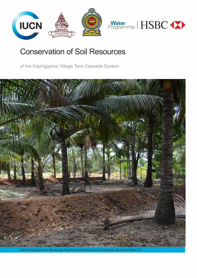
IUCN programme on Restoring Traditional Cascading Tank Systems Technical Note # 6
Conservation of Soil Resources
of the Kapiriggama Village Tank Cascade System
IUCN programme on Restoring Traditional Cascading Tank Systems Technical Note # 6
Conservation of Soil Resources
of the Kapiriggama Small Tank Cascade System
i
The designation of geographical entities in this book, and the presentation of the material, do not imply the expression of any opinion whatsoever on the part of IUCN concerning the legal status of any country, territory, or area, or of its authorities, or concerning the delimitation of its frontiers or boundaries. The views expressed in this publication do not necessarily reflect those of IUCN Published by: IUCN, Sri Lanka Country Office Copyright: © 2016 IUCN, International Union for Conservation of Nature and Natural
Resources
Reproduction of this publication for educational or other non-commercial purposes is authorized without prior written permission from the copyright holder provided the source is fully acknowledged. Reproduction of this publication for resale or other commercial purposes is prohibited without prior written permission of the copyright holder.
Citation: IUCN (2016). Conservation of soil resources. IUCN programme on
Restoring Traditional Cascading Tank Systems Technical Note # 6. Colombo: IUCN, International Union for Conservation of Nature, Colombo, Sri Lanka & Government of Sri Lanka. v + 52 pp.
ISBN: 978-955-0205-37-0 Lead contributor: Dr. P. B. Dharmasena, Consultant, IUCN Cover photo: Soil conservation bunds in a home garden, Kumudu Herath © IUCN Layout by: Padmi Meegoda Produced by: IUCN, Sri Lanka Country Office Available from: IUCN, Sri Lanka Country Office 53, Horton Place
Colombo 7, Sri Lanka Phone: ++94-011-2694094, 2682418, Fax: 2682470 http:// iucn.org/srilanka
ii
Table of Contents
Table of Contents .......................................................................................................................... ii
List of Figures ............................................................................................................................... iv
List of Tables ................................................................................................................................ iv
1. Introduction ................................................................................................................................ 1
1.1 Sri Lanka’s climate and topography ............................................................................ 2
1.2 Climate Change .......................................................................................................... 3
1.3 Land Use in Sri Lanka ................................................................................................. 4
1.4 Soil Types in Sri Lanka ................................................................................................ 6
1.4.1 Reddish Brown Earths (RBE) ......................................................................... 6
1.4.2 Low Humic Gley Soils (LHG) .......................................................................... 6
1.4.3 Non Calcic Brown (NCB) ............................................................................... 7
1.4.4 Alluvial Soils ................................................................................................... 7
1.5 Soil Types and Recommended Land Use Practices .................................................... 8
1.6 Soil Erodibility ........................................................................................................... 10
1.7 Rain Erosivity ............................................................................................................ 11
1.8 Soil Erosion Hazard .................................................................................................. 11
1.9 Erosion: a Threat to Agricultural Production .............................................................. 12
1.10 Land Evaluation ...................................................................................................... 13
2. Sustainable Land Management (SLM) ...................................................................................... 15
2.1 Objectives of Sustainable Land Management ............................................................ 15
2.2 Approach to Sustainable Land Management ............................................................ 16
2.3 Sustainable Land management (SLM) Strategies ...................................................... 17
Strategy 1: Increase soil cover .............................................................................. 17
Strategy 2: Increase soil organic matter content ................................................... 17
Strategy 3: Increase water infiltration and moisture retention capacity ................... 18
Strategy 4: Reduce runoff ..................................................................................... 18
Strategy 5: Improve rooting conditions ............................................................ 18
2.4 Technology of Sustainable Land Management .......................................................... 18
2.4.1 Agronomic practices.................................................................................... 18
2.4.1.1 Mulching ....................................................................................... 19
2.4.1.2 Contour planting ........................................................................... 19
iii
2.4.1.3 Zero tillage .................................................................................... 20
2.4.1.4 Application of organic fertiliser ...................................................... 20
2.4.1.5 Mixed cropping ............................................................................. 21
2.4.2 Vegetative methods ..................................................................................... 22
2.4.2.1 Biological hedges ......................................................................... 22
Alley cropping ............................................................................... 23
Sloping Agricultural Land Technology (SALT) Practice ................... 23
2.4.2.2 Grass hedges ............................................................................... 24
2.4.2.3 Cover crops .................................................................................. 24
2.4.3 Structural Methods ...................................................................................... 25
2.4.3.1 Lock and spill drains ..................................................................... 25
2.4.3.2 Stone bunds ................................................................................. 27
2.4.3.3 Soil bunds and drains ................................................................... 28
2.4.3.4 Terracing ...................................................................................... 31
2.4.3.5 Gully control structures ................................................................. 32
2.4.4 Management Practices ................................................................................ 32
2.4.5 Combined Practices .................................................................................... 36
2.4.5.1 Conservation Farming ................................................................... 36
Hedgerow Cultivation .................................................................... 37
Alley cropping ............................................................................... 37
Conservation of moisture in the top soil ......................................... 37
Mulching ....................................................................................... 37
In-situ rainwater harvesting ........................................................... 37
2.4.5.2 Soil fertility enhancement .............................................................. 39
Crop residues ............................................................................... 39
Green manure ............................................................................... 39
Animal wastes ............................................................................... 40
Compost ....................................................................................... 40
2.4.6 Cost of Structural Methods .................................................................................... 41
3. Project Interventions ................................................................................................................ 43
4. Recommendations for the Future ............................................................................................. 48
Citations ...................................................................................................................................... 49
iv
List of Figures Figure 1. Sri Lanka’s topography and main agro-climatic zones ..................................................... 3 Figure 2.Land use map of Sri Lanka ............................................................................................... 5 Figure 3.Up country land use ......................................................................................................... 6 Figure 4. Two dominant soil types in the Project area: left: Reddish Brown Earths; right: Low Humic Gley Soils (© P. B. Dharmasena) .................................................................................................... 7 Figure 5. Soil map of Sri Lanka ....................................................................................................... 9 Figure 6. Erodible soil ................................................................................................................... 10 Figure 7. Erosion hazard in bare land ........................................................................................... 12 Figure 8. Soil conservation demonstration — DOA, Gannoruwa. .................................................. 13 Figure 9. Terraced lands in the mid country .................................................................................. 15 Figure 10. Increased productivity of soil with good practices ........................................................ 16 Figure 11. Towards a healthy ecosystem ..................................................................................... 16 Figure 12. Mulch applied to cropland ........................................................................................... 19 Figure 13. Contour planting .......................................................................................................... 20 Figure 14. Application of organic fertiliser ..................................................................................... 21 Figure 15. Mixed cropping of pepper and tea ............................................................................... 22 Figure 16. Alley cropping in the dry zone ...................................................................................... 23 Figure 17. SALT practice in the wet zone ..................................................................................... 24 Figure 18. Cover crop in a rubber plantation ................................................................................ 25 Figure 19. Specifications of a lock and spill drain .......................................................................... 26 Figure 20. left: Excavation of drain; right: established grassline .............................................. 27 Figure 21. A stone bund ........................................................................................................... 27 Figure 22. Soil conservation bund ............................................................................................... 28 Figure 23. Preparation of soil conservation bund .......................................................................... 28 Figure 24. Species grown to prevent bund collapse: top left: Vetiveria zizanioides; right: Cymbopogon nardus; bottom left: Justicia adhatoda; right: Cymbopogon citratus ....................... 30 Figure 25. A soil bund stabilised with Gliricidia, Justicia adhatoda, and Citronella ........................ 31 Figure 26. Paddy Terracing .......................................................................................................... 32 Figure 27. Gully control design ..................................................................................................... 33 Figure 28. Dry zone land catena ................................................................................................... 34 Figure 29. Land use model for the dry zone ................................................................................. 35 Figure 30. Land management in cascade systems ....................................................................... 36 Figure 31.Eyebrow bund and pitcher system ............................................................................... 38 Figure 32. Species suitable for green manure: left: Crotalaria juncea; right: Sesbania rostrata ...... 40 Figure 33. Two methods of compost preparation ......................................................................... 41 Figure 34. Participatory planning of farmland development ........................................................... 43 Figure 35. Soil conservation bunds in a home garden .................................................................. 44 Figure 36. Live fencing with multipurpose trees for soil conservation ............................................ 45 Figure 37. Soil electrical conductivity map of Konakumbukwewa command area ......................... 46 Figure 38. Soil health card prepared for paddy lands .................................................................... 47
List of Tables Table 1. Soil types and extent in Sri Lanka ..................................................................................... 7
v
Table 2. Recommended land use for each agro-ecological region .................................................. 8 Table 3. Erodibility of soil types .................................................................................................... 10 Table 4. Erosivity values for different locations .............................................................................. 11 Table 5.Land classes and their use in cultivation .......................................................................... 14 Table 6. Specifications for a lock and spill drain ............................................................................ 26 Table 7. Recommendations for soil bunds and spills for Reddish Brown Earths ........................... 29 Table 8. Recommendations for soil bunds and spills for Non Calcic Brown Earths ....................... 29 Table 9. Recommendations for soil bunds and spills for Red Yellow Latosols ............................... 29 Table 10. Recommendations for soil bunds and spills Reddish Brown Latasolic soils ................... 29 Table 11.Cost rates for structural conservation measures ............................................................ 42
1
1. Introduction Soil, as defined in the Soil Science Society of America Glossary, is ‘the unconsolidated mineral or organic material on the immediate surface of the earth that serves as a natural medium for the growth of land plants’ (https://www.soils.org/files/about-soils/soils-overview.pdf). In agriculture, soil is defined as ‘a dynamic natural body on the surface of the earth in which plants grow, composed of mineral and organic materials and living forms’ (Brady, 1974: 617). Soils provide many essential services in both natural and human-made ecosystems: they serve as a medium on which different kinds of plants grow; they absorb and emit gases (such as carbon dioxide, methane, water vapour) and dust and thereby modify the atmosphere; they provide a habitat for soil-dwelling organisms; they soak up, retain, release and alter most of the water in land systems; they recycle nutrients, including carbon, so that living things can use them over and over again; they serve as a medium for engineering for the construction of foundations, roadbeds, dams and buildings; and they function as a living filter to purify water before it moves into groundwater (https://www.soils.org/files/about-soils/soils-overview.pdf). Soil is formed (pedogenesis) from the process of weathering —‘the breakdown of the material under the influence of gravity, wind and water, accelerated by the chemical and physical effects of plant roots and animal action’ (http://soils.org.uk/soil-forming-factors-and-processes). Pedogenesis is a slow process, which takes many years. Such soil that is created, is, at the same time, eroded. In geology, ‘erosion is the action of surface processes (such as water flow or wind) that remove soil, rock, or dissolved material from one location on the Earth's crust, then transport it away to another location’ (https://en.wikipedia.org/wiki/Erosion). The erosion process is accelerated when the surface cover is removed or the soil is disturbed. The process includes detachment of soil, transport and deposition. The severity of soil erosion is determined by four main factors: the energy of rainfall, soil stability, landscape and surface cover. Such erosion is a natural process, but anthropogenic activities have increased the rate of erosion to 40-50 times the natural rate (https://en.wikipedia.org/wiki/Erosion). Such human activities include intensive agriculture, deforestation, infrastructure development, urbanisation and climate change. The most important impacts of accelerated soil erosion include the decrease in agricultural productivity in agricultural system and ecological collapse in natural ecosystems, as a consequence of the loss of upper soil layers, which are rich in nutrients. The impacts of soil erosion off-site ‘include sedimentation of waterways and eutrophication of water bodies, as well as sediment-related damage to roads and houses’ (Blanco-Canqui and Rattan, 2008). Soil erosion in Sri Lanka is a serious problem. It has numerous impacts on crop productivity, economic growth, income distribution, food production and long-term environmental stability.
2
Hewawasam et al (2003) calculated that soil loss in the upper catchment area of the Mahaweli River is 130 – 2,100 tkm-2yr-1. They also calculated that the rate of soil erosion from agricultural lands on hill slopes were 7,000 tkm-2yr-1. In comparison with natural rates of erosion, they note that in the agricultural areas of the central highlands of Sri Lanka, soil is lost 10-100 times faster than it is produced (Hewawasam et al., 2003). In cotton-cultivated plots and sorghum/pigeon pea inter-cropped plots without any soil conservation measures, the annual soil loss was 22.2 t ha-1 and 21.3 t ha-1 ha respectively (cited in Dharmasena, 2003). Soil erosion in a maha season can be as high as 54 t ha-1 from chena lands (Dharmasena, 1992a). About 70% percent of yala rainfall and 50-55% of maha rainfall are erosive (Dharmasena1992b). Annual erosivity in the central dry zone ranges from 116 t m ha-1 (in Maha Illuppallama) to 162 t m ha-1 (in Kantale), and 55-65% of annual erosive rains occur during the maha season (Dharmasena, 2003). Rain-fed farming areas in dry and intermediate zones become less productive because proper soil conservation measures are not being adopted, indicating that the mismanagement of land and improper land uses are the main causes for accelerating soil erosion. To conserve soil resources, the Kapirriggama Cascade project had the overall goal of achieving good management of agricultural systems to enhance the soil tilth1 and soil productivity of the catchment, and the following specific objectives:
1. to minimise soil erosion;
2. to enhance soil moisture;
3. to enhance soil fertility;
4. to decrease soil and water pollution by minimising the use of agrochemicals; and
5. to increase the resilience of upland agricultural systems against drought. 1.1 Sri Lanka’s climate and topography
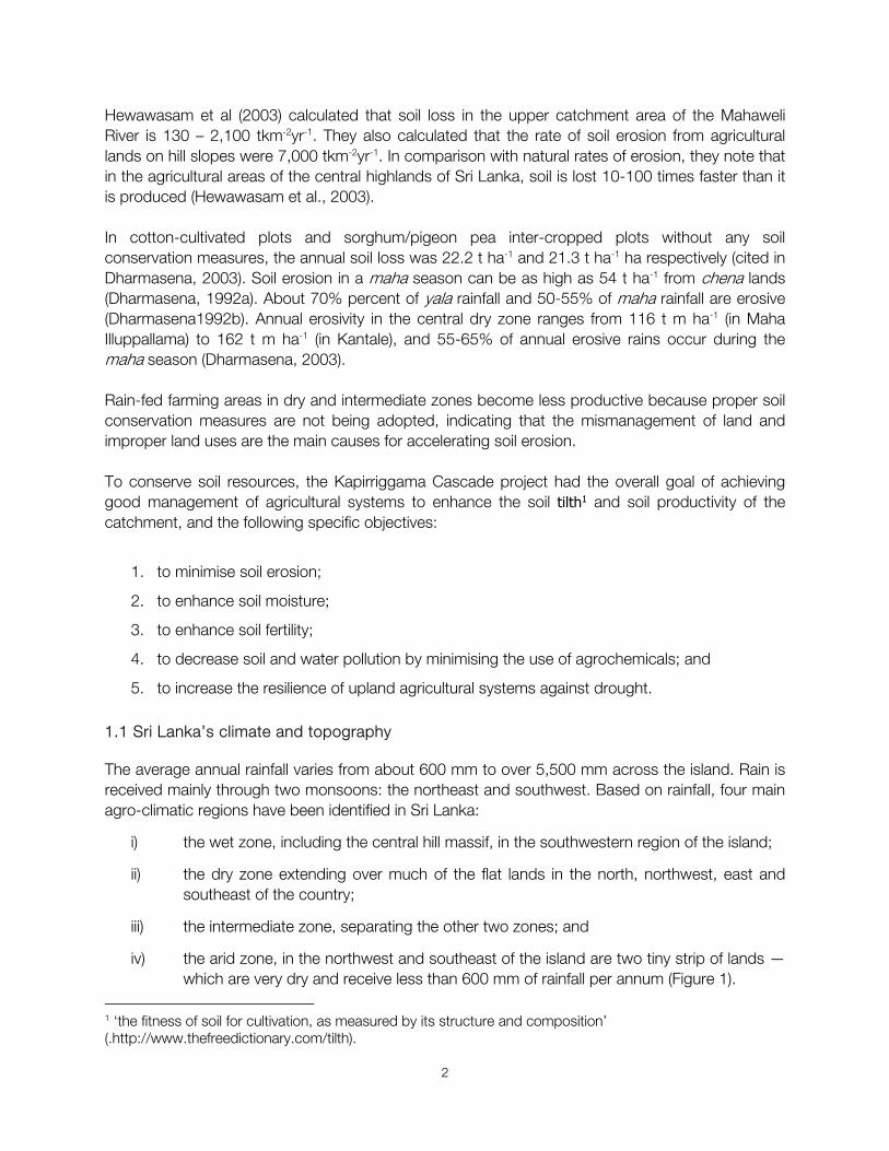
The average annual rainfall varies from about 600 mm to over 5,500 mm across the island. Rain is received mainly through two monsoons: the northeast and southwest. Based on rainfall, four main agro-climatic regions have been identified in Sri Lanka:
i) the wet zone, including the central hill massif, in the southwestern region of the island;
ii) the dry zone extending over much of the flat lands in the north, northwest, east and southeast of the country;
iii) the intermediate zone, separating the other two zones; and
iv) the arid zone, in the northwest and southeast of the island are two tiny strip of lands — which are very dry and receive less than 600 mm of rainfall per annum (Figure 1).
1 ‘the fitness of soil for cultivation, as measured by its structure and composition’ (.http://www.thefreedictionary.com/tilth).
3
The wet zone receives a high mean annual rainfall over 2,500 mm without a pronounced dry period; while the dry zone receives a mean annual rainfall of less than 1,750 mm with a distinct dry season from May to September. The intermediate zone receives a mean annual rainfall between 1,750 to 2,500 mm with a short, and less prominent dry season. The mean annual temperature is about 27°C in the lowlands and 15°C in the central highlands. The temperature decreases with increasing altitude, approximately 2°C per 300 m of elevation (Survey Dept., 2007).
Figure 1. Sri Lanka’s topography and main agro-climatic zones (Source: drawn from the National Atlas, Survey Dept., 2007)
1.2 Climate Change
‘Climate change refers to a statistically significant variation in either the mean state of the climate or in its variability, persisting for an extended period (typically decades or longer). Climate change may be due to natural internal processes or external forcings, or to persistent anthropogenic changes in
4
the composition of the atmosphere or in land use’ (http://www.ipcc.ch/ipccreports/tar/vol4/index.php?idp=204).
During the last century, the concentration of CO2 in the atmosphere has risen by twelvefold, through excessive use of coal and oil, countless vehicles that use up gallons of petrol, and industries that emit enormous quantities of CO2 into atmosphere. Meanwhile, forests (that serve to soak up CO2) are being cut down. Global carbon dioxide (CO2) emissions from fossil fuel combustion and from industrial processes (cement and metal production) increased in 2013 to the new record of 35.3 billion tonnes (Gt) CO2 (IPCC, 2014; Olivier et al., 2014).
The result of these emissions and increased greenhouse effect is a distinct warming of the earth. During the last century, global temperature increased by about 0.8°C — measured as the largest increase in thousand years. The ten warmest years on record have all been in the last two decades and 2015 was recorded to be the hottest year on record (http://news.nationalgeographic.com/2015/11/151124-2015-hottest-year-record-global-warming-climate-change-science/; IPCC, 2014). This global warming is causing climate change: melting ice caps, changing weather patterns and ocean currents, increasing extreme weather events and spreading disease. Climate change, therefore, is causing overwhelming changes in ecosystems and to their services. Annual mean air temperature anomalies have shown significant increasing trends in Sri Lanka (Basnayake et al., 2002). The rate of increase of mean air temperature for the 1961-1990 period is in the order of 0.016°C per year (Basnayake et al., 2002). ‘Annual mean maximum air temperatures have shown increasing trends in almost all stations with the maximum rate of increase about 0.021°C per year in Puttalam. Night-time annual mean minimum air temperatures have also shown increasing trends with higher gradients’ (http://www.meteo.gov.lk/index.php?option=com_content&view=article&id=14&Itemid=133&lang=en#temperature-change ).
The maximum rate of increase of night-time annual mean minimum air temperature is reported as 0.02°C per year at Nuwara-Eliya (Survey Dept., 2007). Temperature related extreme indices have increased over most locations in Sri Lanka. Annual average rainfall over Sri Lanka has been decreasing for the last 57 years at a rate of about 7 mm per year (Chandrapala, 1996. The coefficient of variation of rainfall distribution from 1931 to 1960 is greater during the northeast monsoon and the second inter-monsoon period (the maha season) when compared to the period from 1961 – 1990. The southwest monsoon rainfall has not shown any significant change during these two periods (Chandrapala and Fernando, 1995).
Climate change is expected to have ‘significant impacts on soil erosion rates’ (Nearing et al. 2004).
1.3 Land Use in Sri Lanka
The land area of Sri Lanka is 65,610 km2 (Survey Dept., 2007). Of this, nearly two million hectares are used for agricultural purposes (Dept. of Census and Statistics, 2016). Major plantation crops extend over 740,805 ha (Department of Census and Statistics, 2016) and another 0.18 million ha are occupied by other permanent crops (Department of Census and Statistics, 1988). These two categories, if managed well, do not create any issues related to soil erosion.
5
Paddy farming is practised in an extent of 300,725 ha (Dept. of Census and Statistics, 2016). In addition, about 0.2 million ha are annually planted with assorted field crops (Department of Census and Statistics, 1988). In general, permanent crop lands are more protected from erosion than annually cultivated lands.
Tea lands on hill slopes tend to erode at very high rates if they are managed poorly.
The average size of a small-holding in Sri Lanka declined by 64% over the last 56 years, from 1.3 ha in 1946 to 0.47 ha by 2002 (Dept. of Census and Statistics, 2002), while 66% of cropland is rain-fed (http://www.ips.lk/talkingeconomics/2013/03/22) and therefore, increasingly vulnerable to impacts of climate variability and climate extremes.
Figure 2.Land use map of Sri Lanka (Source: Survey Dept., 2007)
6
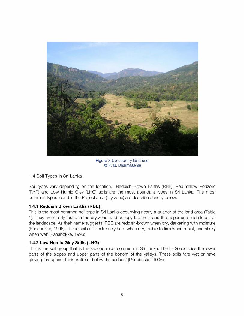
Figure 3.Up country land use (© P. B. Dharmasena)
1.4 Soil Types in Sri Lanka
Soil types vary depending on the location. Reddish Brown Earths (RBE), Red Yellow Podzolic (RYP) and Low Humic Gley (LHG) soils are the most abundant types in Sri Lanka. The most common types found in the Project area (dry zone) are described briefly below.
1.4.1 Reddish Brown Earths (RBE): This is the most common soil type in Sri Lanka occupying nearly a quarter of the land area (Table 1). They are mainly found in the dry zone, and occupy the crest and the upper and mid-slopes of the landscape. As their name suggests, RBE are reddish-brown when dry, darkening with moisture (Panabokke, 1996). These soils are ‘extremely hard when dry, friable to firm when moist, and sticky when wet’ (Panabokke, 1996).
1.4.2 Low Humic Gley Soils (LHG) This is the soil group that is the second most common in Sri Lanka. The LHG occupies the lower parts of the slopes and upper parts of the bottom of the valleys. These soils ‘are wet or have gleying throughout their profile or below the surface’ (Panabokke, 1996).
8
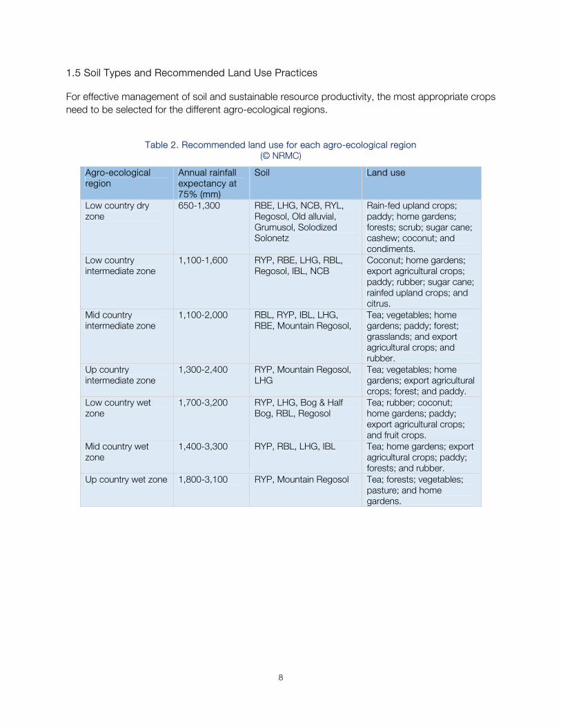
1.5 Soil Types and Recommended Land Use Practices
For effective management of soil and sustainable resource productivity, the most appropriate crops need to be selected for the different agro-ecological regions.
Table 2. Recommended land use for each agro-ecological region (© NRMC)
Agro-ecological region
Annual rainfall expectancy at 75% (mm)
Soil Land use
Low country dry zone
650-1,300 RBE, LHG, NCB, RYL, Regosol, Old alluvial, Grumusol, Solodized Solonetz
Rain-fed upland crops;paddy; home gardens; forests; scrub; sugar cane; cashew; coconut; and condiments.
Low country intermediate zone
1,100-1,600 RYP, RBE, LHG, RBL, Regosol, IBL, NCB
Coconut; home gardens;export agricultural crops; paddy; rubber; sugar cane; rainfed upland crops; and citrus.
Mid country intermediate zone
1,100-2,000 RBL, RYP, IBL, LHG, RBE, Mountain Regosol,
Tea; vegetables; home gardens; paddy; forest; grasslands; and export agricultural crops; and rubber.
Up country intermediate zone
1,300-2,400 RYP, Mountain Regosol, LHG
Tea; vegetables; home gardens; export agricultural crops; forest; and paddy.
Low country wet zone
1,700-3,200 RYP, LHG, Bog & Half Bog, RBL, Regosol
Tea; rubber; coconut;home gardens; paddy; export agricultural crops; and fruit crops.
Mid country wet zone
1,400-3,300 RYP, RBL, LHG, IBL Tea; home gardens; export agricultural crops; paddy; forests; and rubber.
Up country wet zone 1,800-3,100 RYP, Mountain Regosol Tea; forests; vegetables;pasture; and home gardens.
9
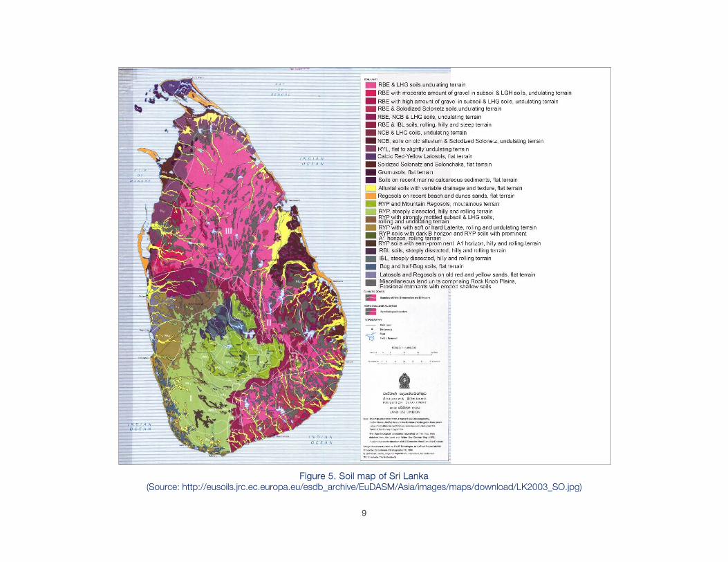
Figure 5. Soil map of Sri Lanka (Source: http://eusoils.jrc.ec.europa.eu/esdb_archive/EuDASM/Asia/images/maps/download/LK2003_SO.jpg)
10
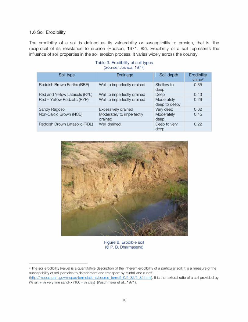
1.6 Soil Erodibility
The erodibility of a soil is defined as its vulnerability or susceptibility to erosion, that is, the reciprocal of its resistance to erosion (Hudson, 1971: 82). Erodibility of a soil represents the influence of soil properties in the soil erosion process. It varies widely across the country.
Table 3. Erodibility of soil types (Source: Joshua, 1977)
Soil type Drainage Soil depth Erodibility value2
Reddish Brown Earths (RBE) Well to imperfectly drained Shallow to deep
0.35
Red and Yellow Latasols (RYL) Well to imperfectly drained Deep 0.43Red – Yellow Podzolic (RYP) Well to imperfectly drained Moderately
deep to deep, 0.29
Sandy Regosol Excessively drained Very deep 0.62Non-Calcic Brown (NCB) Moderately to imperfectly
drained Moderately deep
0.45
Reddish Brown Latasolic (RBL) Well drained Deep to very deep
0.22
Figure 6. Erodible soil (© P. B. Dharmasena)
2 The soil erodibility [value] is a quantitative description of the inherent erodibility of a particular soil; it is a measure of the susceptibility of soil particles to detachment and transport by rainfall and runoff (http://mepas.pnnl.gov/mepas/formulations/source_term/5_0/5_32/5_32.html). It is the textural ratio of a soil provided by (% silt + % very fine sand) x (100 - % clay) (Wischmeier et al., 1971).
11
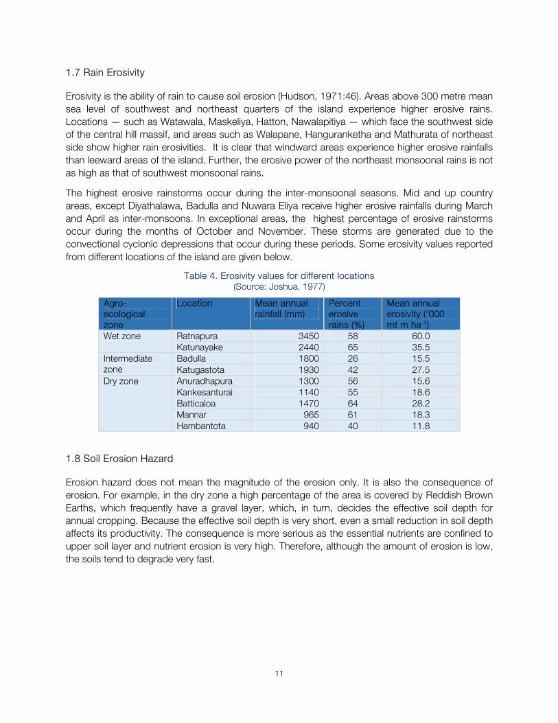
1.7 Rain Erosivity
Erosivity is the ability of rain to cause soil erosion (Hudson, 1971:46). Areas above 300 metre mean sea level of southwest and northeast quarters of the island experience higher erosive rains. Locations — such as Watawala, Maskeliya, Hatton, Nawalapitiya — which face the southwest side of the central hill massif, and areas such as Walapane, Hanguranketha and Mathurata of northeast side show higher rain erosivities. It is clear that windward areas experience higher erosive rainfalls than leeward areas of the island. Further, the erosive power of the northeast monsoonal rains is not as high as that of southwest monsoonal rains.
The highest erosive rainstorms occur during the inter-monsoonal seasons. Mid and up country areas, except Diyathalawa, Badulla and Nuwara Eliya receive higher erosive rainfalls during March and April as inter-monsoons. In exceptional areas, the highest percentage of erosive rainstorms occur during the months of October and November. These storms are generated due to the convectional cyclonic depressions that occur during these periods. Some erosivity values reported from different locations of the island are given below.
Table 4. Erosivity values for different locations (Source: Joshua, 1977)
Agro-ecological zone
Location Mean annual rainfall (mm)
Percent erosive rains (%)
Mean annual erosivity (‘000 mt m ha-1)
Wet zone Ratnapura 3450 58 60.0 Katunayake 2440 65 35.5
Intermediate zone
Badulla 1800 26 15.5 Katugastota 1930 42 27.5
Dry zone Anuradhapura 1300 56 15.6 Kankesanturai 1140 55 18.6 Batticaloa 1470 64 28.2 Mannar 965 61 18.3 Hambantota 940 40 11.8
1.8 Soil Erosion Hazard
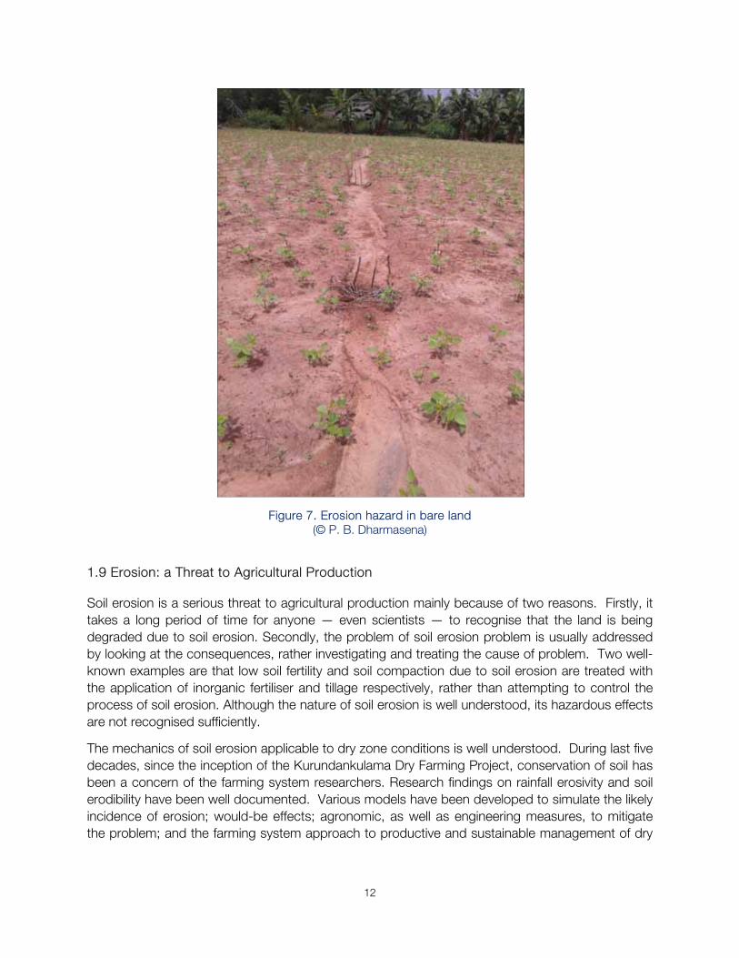
Erosion hazard does not mean the magnitude of the erosion only. It is also the consequence of erosion. For example, in the dry zone a high percentage of the area is covered by Reddish Brown Earths, which frequently have a gravel layer, which, in turn, decides the effective soil depth for annual cropping. Because the effective soil depth is very short, even a small reduction in soil depth affects its productivity. The consequence is more serious as the essential nutrients are confined to upper soil layer and nutrient erosion is very high. Therefore, although the amount of erosion is low, the soils tend to degrade very fast.
12
Figure 7. Erosion hazard in bare land (© P. B. Dharmasena)
1.9 Erosion: a Threat to Agricultural Production
Soil erosion is a serious threat to agricultural production mainly because of two reasons. Firstly, it takes a long period of time for anyone — even scientists — to recognise that the land is being degraded due to soil erosion. Secondly, the problem of soil erosion problem is usually addressed by looking at the consequences, rather investigating and treating the cause of problem. Two well-known examples are that low soil fertility and soil compaction due to soil erosion are treated with the application of inorganic fertiliser and tillage respectively, rather than attempting to control the process of soil erosion. Although the nature of soil erosion is well understood, its hazardous effects are not recognised sufficiently.
The mechanics of soil erosion applicable to dry zone conditions is well understood. During last five decades, since the inception of the Kurundankulama Dry Farming Project, conservation of soil has been a concern of the farming system researchers. Research findings on rainfall erosivity and soil erodibility have been well documented. Various models have been developed to simulate the likely incidence of erosion; would-be effects; agronomic, as well as engineering measures, to mitigate the problem; and the farming system approach to productive and sustainable management of dry
13
zone farm lands. Agricultural development projects have emphasised soil conservation as a major component in their work plans.
However, severe land degradation, as a consequence of soil erosion, continues unabated.
A few questions arise in finding proper solutions to the problem of soil erosion.
Do we have sound technology to control soil erosion?
Why is it that farmers do not realise the danger that their lands face, if cultivated without conserving the soil?
Would farming be profitable if the soil conservation is integrated to the existing practices?
What could extension agencies do to make the soil conservation a reality?
How can the Government share the responsibility of conserving land resources with land users?
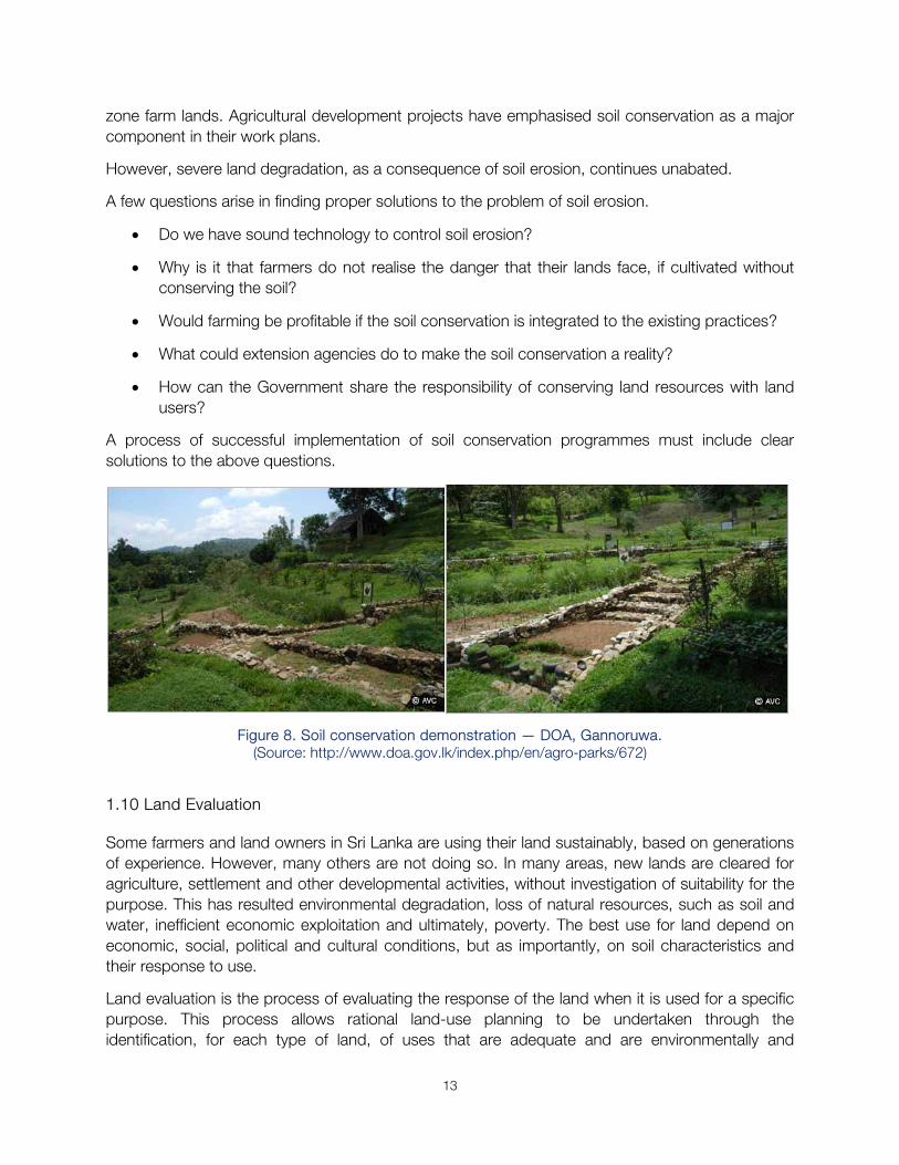
A process of successful implementation of soil conservation programmes must include clear solutions to the above questions.
Figure 8. Soil conservation demonstration — DOA, Gannoruwa. (Source: http://www.doa.gov.lk/index.php/en/agro-parks/672)
1.10 Land Evaluation
Some farmers and land owners in Sri Lanka are using their land sustainably, based on generations of experience. However, many others are not doing so. In many areas, new lands are cleared for agriculture, settlement and other developmental activities, without investigation of suitability for the purpose. This has resulted environmental degradation, loss of natural resources, such as soil and water, inefficient economic exploitation and ultimately, poverty. The best use for land depend on economic, social, political and cultural conditions, but as importantly, on soil characteristics and their response to use.
Land evaluation is the process of evaluating the response of the land when it is used for a specific purpose. This process allows rational land-use planning to be undertaken through the identification, for each type of land, of uses that are adequate and are environmentally and
14
economically sustainable for the natural and human resources. In this manner, land evaluation can be an important tool for land use, for individual users, for groups, or for society as a whole.
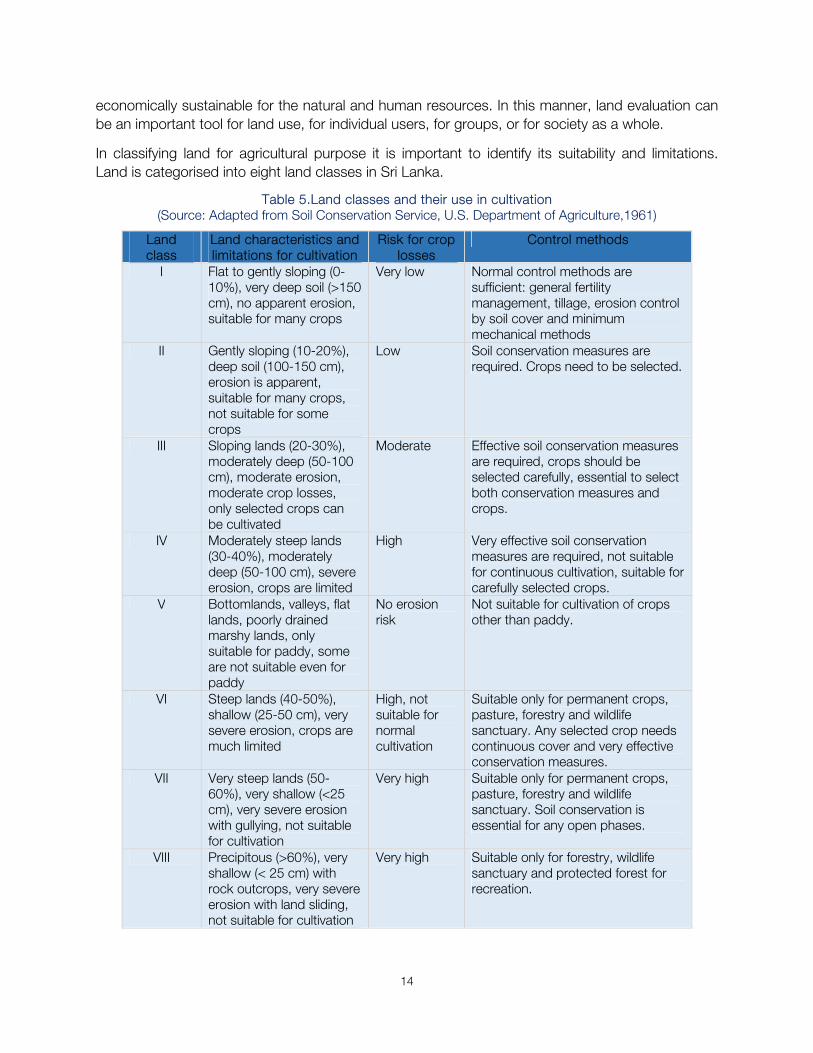
In classifying land for agricultural purpose it is important to identify its suitability and limitations. Land is categorised into eight land classes in Sri Lanka.
Table 5.Land classes and their use in cultivation (Source: Adapted from Soil Conservation Service, U.S. Department of Agriculture,1961)
Land class
Land characteristics and limitations for cultivation
Risk for crop losses
Control methods
I Flat to gently sloping (0-10%), very deep soil (>150 cm), no apparent erosion, suitable for many crops
Very low Normal control methods are sufficient: general fertility management, tillage, erosion control by soil cover and minimum mechanical methods
II Gently sloping (10-20%), deep soil (100-150 cm), erosion is apparent, suitable for many crops, not suitable for some crops
Low Soil conservation measures are required. Crops need to be selected.
III Sloping lands (20-30%), moderately deep (50-100 cm), moderate erosion, moderate crop losses, only selected crops can be cultivated
Moderate Effective soil conservation measures are required, crops should be selected carefully, essential to select both conservation measures and crops.
IV Moderately steep lands (30-40%), moderately deep (50-100 cm), severe erosion, crops are limited
High Very effective soil conservation measures are required, not suitable for continuous cultivation, suitable for carefully selected crops.
V Bottomlands, valleys, flat lands, poorly drained marshy lands, only suitable for paddy, some are not suitable even for paddy
No erosion risk
Not suitable for cultivation of crops other than paddy.
VI Steep lands (40-50%), shallow (25-50 cm), very severe erosion, crops are much limited
High, not suitable for normal cultivation
Suitable only for permanent crops, pasture, forestry and wildlife sanctuary. Any selected crop needs continuous cover and very effective conservation measures.
VII Very steep lands (50-60%), very shallow (<25 cm), very severe erosion with gullying, not suitable for cultivation
Very high Suitable only for permanent crops, pasture, forestry and wildlife sanctuary. Soil conservation is essential for any open phases.
VIII Precipitous (>60%), very shallow (< 25 cm) with rock outcrops, very severe erosion with land sliding, not suitable for cultivation
Very high Suitable only for forestry, wildlife sanctuary and protected forest for recreation.
15
2. Sustainable Land Management (SLM)
There are many definitions of sustainable land management, some of which are given below.
‘SLM is the use of land resources, including soils, water, animals and plants, for the production of goods to meet changing human needs, while simultaneously ensuring the long-term productive potential of these resources and the maintenance of their environmental functions’ (WOCAT, 2008).
‘Land management is the process by which the resources of land are put to good effect. It covers all activities concerned with the management of land as a resource both from an environmental and from an economic perspective. It can include farming, mineral extraction, property and estate management, and the physical planning of towns and the countryside’ (UN, 1996).
Sustainable land management is a knowledge-based procedure that helps integrate land, water, biodiversity, and environmental management (including input and output externalities) to meet rising food and fiber demands while sustaining ecosystem services and livelihoods. SLM is necessary to meet the requirements of a growing population. Improper land management can lead to land degradation and a significant reduction in the productive and service functions (World Bank 2006 in litt. World Bank 2008).
2.1 Objectives of Sustainable Land Management
There are two broad objectives of SLM
1. Maintaining long term productivity of ecosystem functions (land, water, biodiversity); and
2. Increasing productivity (quality, quantity and diversity) of goods and services, particularly safe and healthy food.
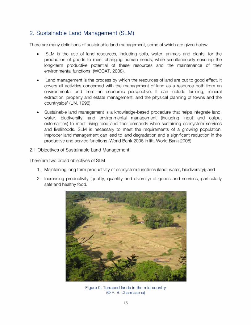
Figure 9. Terraced lands in the mid country (© P. B. Dharmasena)
16
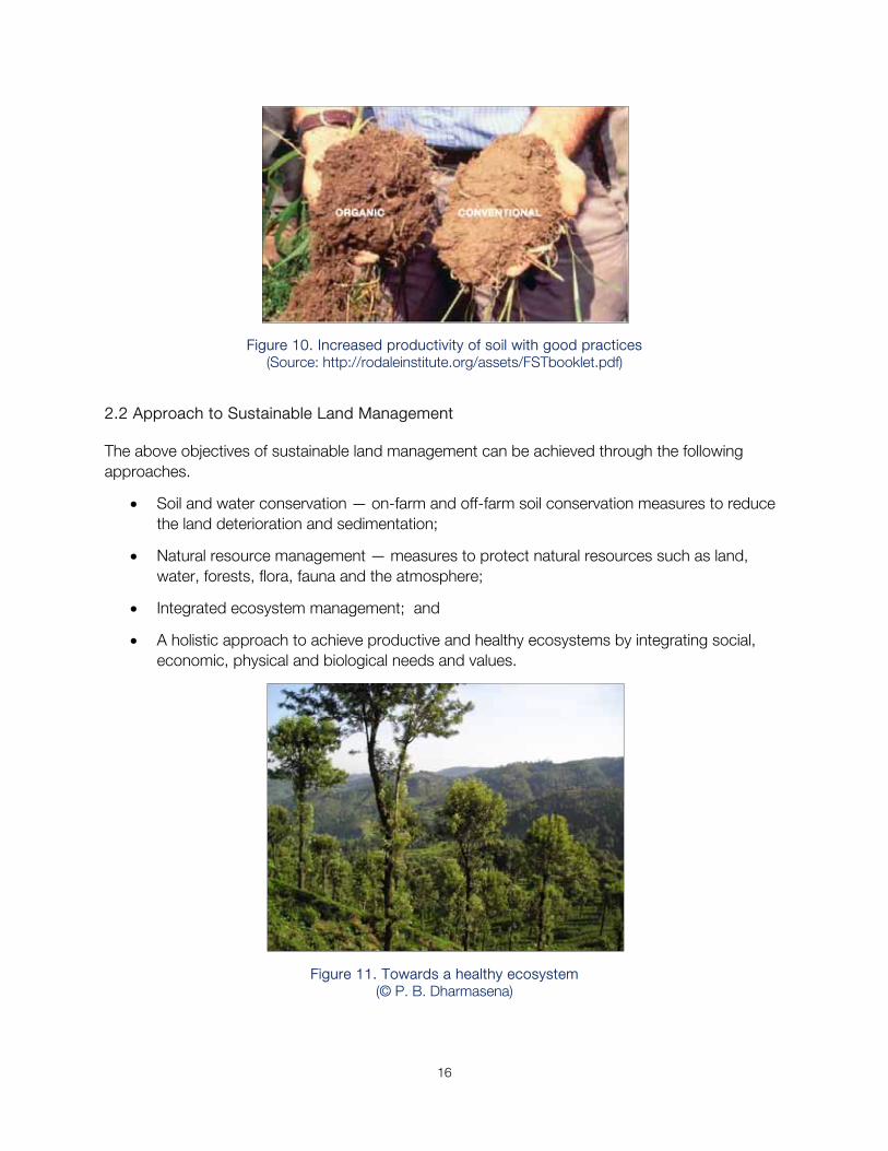
Figure 10. Increased productivity of soil with good practices (Source: http://rodaleinstitute.org/assets/FSTbooklet.pdf)
2.2 Approach to Sustainable Land Management
The above objectives of sustainable land management can be achieved through the following approaches.
Soil and water conservation — on-farm and off-farm soil conservation measures to reduce the land deterioration and sedimentation;
Natural resource management — measures to protect natural resources such as land, water, forests, flora, fauna and the atmosphere;
Integrated ecosystem management; and
A holistic approach to achieve productive and healthy ecosystems by integrating social, economic, physical and biological needs and values.
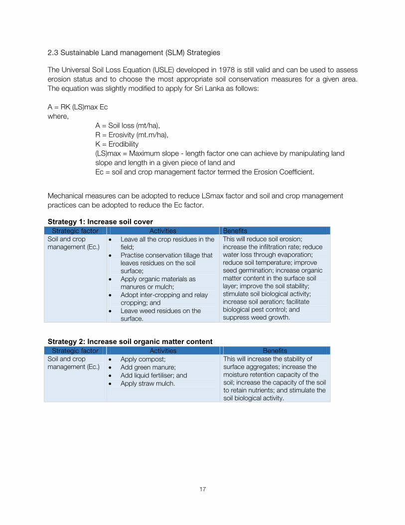
Figure 11. Towards a healthy ecosystem (© P. B. Dharmasena)
17
2.3 Sustainable Land management (SLM) Strategies
The Universal Soil Loss Equation (USLE) developed in 1978 is still valid and can be used to assess erosion status and to choose the most appropriate soil conservation measures for a given area. The equation was slightly modified to apply for Sri Lanka as follows:
A = RK (LS)max Ec where,
A = Soil loss (mt/ha), R = Erosivity (mt.m/ha), K = Erodibility (LS)max = Maximum slope - length factor one can achieve by manipulating land slope and length in a given piece of land and Ec = soil and crop management factor termed the Erosion Coefficient.
Mechanical measures can be adopted to reduce LSmax factor and soil and crop management practices can be adopted to reduce the Ec factor.
Strategy 1: Increase soil cover Strategic factor Activities Benefits
Soil and crop management (Ec.)
Leave all the crop residues in the field;
Practise conservation tillage that leaves residues on the soil surface;
Apply organic materials as manures or mulch;
Adopt inter-cropping and relay cropping; and
Leave weed residues on the surface.
This will reduce soil erosion; increase the infiltration rate; reduce water loss through evaporation; reduce soil temperature; improve seed germination; increase organic matter content in the surface soil layer; improve the soil stability; stimulate soil biological activity; increase soil aeration; facilitate biological pest control; and suppress weed growth.
Strategy 2: Increase soil organic matter content Strategic factor Activities Benefits
Soil and crop management (Ec.)
Apply compost; Add green manure; Add liquid fertiliser; and Apply straw mulch.
This will increase the stability of surface aggregates; increase the moisture retention capacity of the soil; increase the capacity of the soil to retain nutrients; and stimulate the soil biological activity.
18
Strategy 3: Increase water infiltration and moisture retention capacity Strategic factor Activities Benefits
Soil and crop management (Ec.)
Maintain a protective cover of residues over the soil;
Reduce wind velocity by installing wind breaks;
Create surface roughness between crop rows;
Keep fallow periods between cropping; and
Apply organic fertiliser.
This will reduce crop moisture deficit; increase the yield and production of the crop biomass; and reduce runoff.
Mechanical measures (LSmax)
Adopt contour ridging; and Reduce the land slope by
terracing.
This will reduce runoff; and increase yield and production of the crop biomass.
Strategy 4: Reduce runoff Strategic factor Activities Benefits
Mechanical measures (LSmax)
Collect the runoff in structures within which the water can infiltrate;
Construct structures that collect and lead the runoff away from the field; and
Establish permeable barriers along the lines of contours to reduce runoff velocity.
This will reduce the losses of soil, water, nutrients, fertilisers and pesticides; increase the moisture available to the crop; and consequently, grain yield and biomass production.
Strategy 5: Improve rooting conditions Strategy Activities Benefits
Soil and crop management (Ec.)
Loosen the soil around plants to reduce compaction and increase porosity;
Improve drainage by placing drainage channels where soils are poorly or imperfectly drained;
Make furrows or raised beds.
This will improve root development and growth, and, as a result, the crop will absorb more moisture and nutrients. It will reduce probability that the crops will suffer from drought.
2.4 Technology of Sustainable Land Management
This technology comprises four different practices namely, agronomic practices, vegetative methods, structural methods and management or a combination of these.
2.4.1 Agronomic practices The following agronomic practices are recommended.
Mulching;
Contour planting;
Zero tillage;
19
Application of organic fertiliser; and
Mixed cropping.
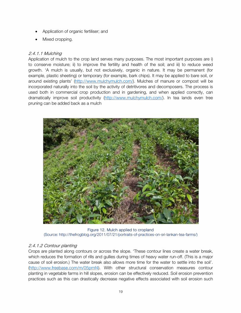
2.4.1.1 Mulching Application of mulch to the crop land serves many purposes. The most important purposes are i) to conserve moisture; ii) to improve the fertility and health of the soil; and iii) to reduce weed growth. ‘A mulch is usually, but not exclusively, organic in nature. It may be permanent (for example, plastic sheeting) or temporary (for example, bark chips). It may be applied to bare soil, or around existing plants’ (http://www.mulchymulch.com/). Mulches of manure or compost will be incorporated naturally into the soil by the activity of detritivores and decomposers. The process is used both in commercial crop production and in gardening, and when applied correctly, can dramatically improve soil productivity (http://www.mulchymulch.com/). In tea lands even tree pruning can be added back as a mulch
Figure 12. Mulch applied to cropland (Source: http://thefrogblog.org/2011/07/21/portraits-of-practices-on-sri-lankan-tea-farms/)
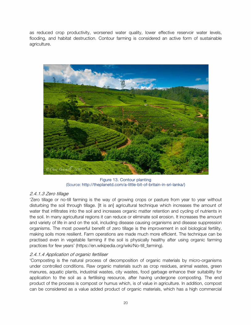
2.4.1.2 Contour planting Crops are planted along contours or across the slope. ‘These contour lines create a water break, which reduces the formation of rills and gullies during times of heavy water run-off. (This is a major cause of soil erosion.) The water break also allows more time for the water to settle into the soil’. (http://www.freebase.com/m/05pmf4). With other structural conservation measures contour planting in vegetable farms in hill slopes, erosion can be effectively reduced. Soil erosion prevention practices such as this can drastically decrease negative effects associated with soil erosion such
20
as reduced crop productivity, worsened water quality, lower effective reservoir water levels, flooding, and habitat destruction. Contour farming is considered an active form of sustainable agriculture.
Figure 13. Contour planting
(Source: http://theplanetd.com/a-little-bit-of-britain-in-sri-lanka/)
2.4.1.3 Zero tillage ‘Zero tillage or no-till farming is the way of growing crops or pasture from year to year without disturbing the soil through tillage. [It is an] agricultural technique which increases the amount of water that infiltrates into the soil and increases organic matter retention and cycling of nutrients in the soil. In many agricultural regions it can reduce or eliminate soil erosion. It increases the amount and variety of life in and on the soil, including disease causing organisms and disease suppression organisms. The most powerful benefit of zero tillage is the improvement in soil biological fertility, making soils more resilient. Farm operations are made much more efficient. The technique can be practised even in vegetable farming if the soil is physically healthy after using organic farming practices for few years’ (https://en.wikipedia.org/wiki/No-till_farming).
2.4.1.4 Application of organic fertiliser ‘Composting is the natural process of decomposition of organic materials by micro-organisms under controlled conditions. Raw organic materials such as crop residues, animal wastes, green manures, aquatic plants, industrial wastes, city wastes, food garbage enhance their suitability for application to the soil as a fertilising resource, after having undergone composting. The end product of the process is compost or humus which, is of value in agriculture. In addition, compost can be considered as a value added product of organic materials, which has a high commercial
21
value when compared to many other forms of organic materials. This is recommended especially for tea lands and for vegetable cultivation’ (http://www.agrimin.gov.lk/web/index.php/en/project/12-project/26-promotion-of-production).
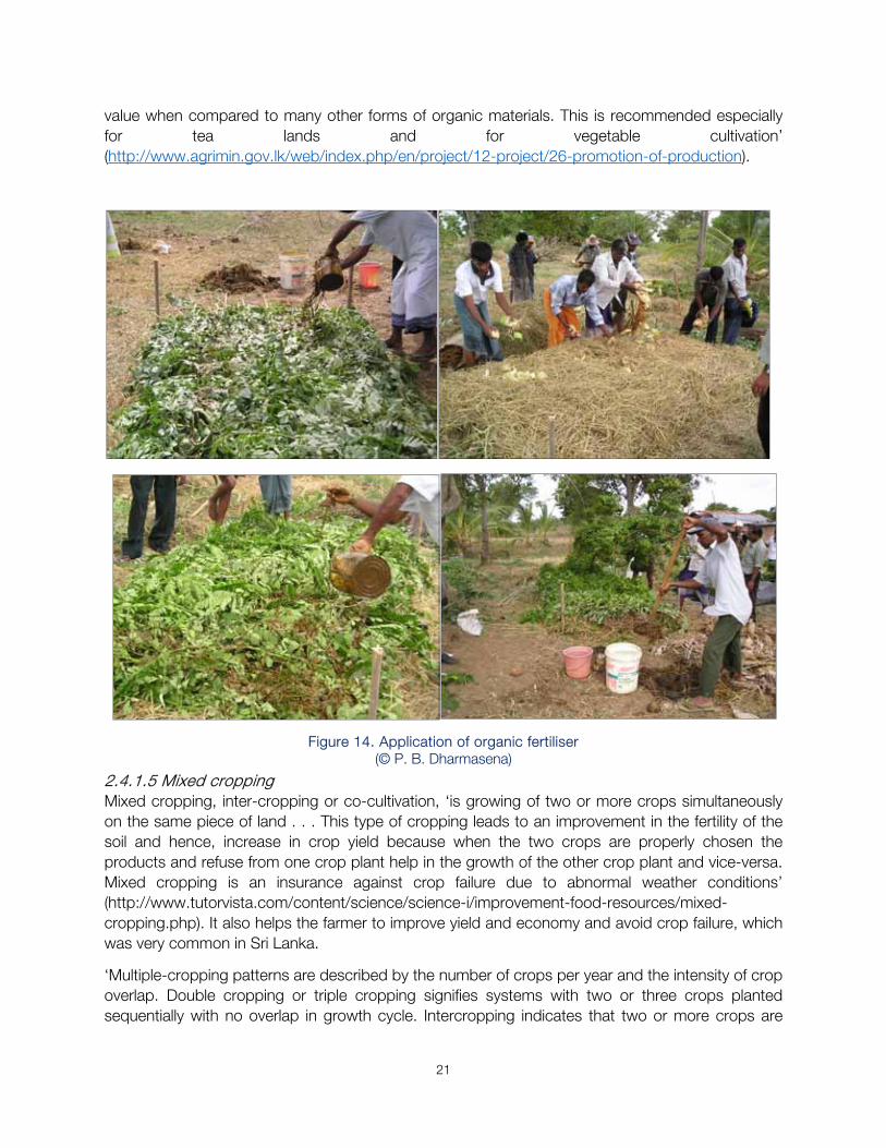
Figure 14. Application of organic fertiliser (© P. B. Dharmasena)
2.4.1.5 Mixed cropping Mixed cropping, inter-cropping or co-cultivation, ‘is growing of two or more crops simultaneously on the same piece of land . . . This type of cropping leads to an improvement in the fertility of the soil and hence, increase in crop yield because when the two crops are properly chosen the products and refuse from one crop plant help in the growth of the other crop plant and vice-versa. Mixed cropping is an insurance against crop failure due to abnormal weather conditions’ (http://www.tutorvista.com/content/science/science-i/improvement-food-resources/mixed-cropping.php). It also helps the farmer to improve yield and economy and avoid crop failure, which was very common in Sri Lanka.
‘Multiple-cropping patterns are described by the number of crops per year and the intensity of crop overlap. Double cropping or triple cropping signifies systems with two or three crops planted sequentially with no overlap in growth cycle. Intercropping indicates that two or more crops are
22
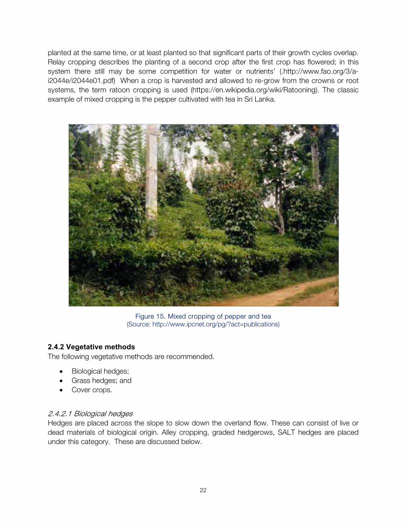
planted at the same time, or at least planted so that significant parts of their growth cycles overlap. Relay cropping describes the planting of a second crop after the first crop has flowered; in this system there still may be some competition for water or nutrients’ (.http://www.fao.org/3/a-i2044e/i2044e01.pdf) When a crop is harvested and allowed to re-grow from the crowns or root systems, the term ratoon cropping is used (https://en.wikipedia.org/wiki/Ratooning). The classic example of mixed cropping is the pepper cultivated with tea in Sri Lanka.
Figure 15. Mixed cropping of pepper and tea (Source: http://www.ipcnet.org/pg/?act=publications)
2.4.2 Vegetative methods The following vegetative methods are recommended.
Biological hedges; Grass hedges; and Cover crops.
2.4.2.1 Biological hedges Hedges are placed across the slope to slow down the overland flow. These can consist of live or dead materials of biological origin. Alley cropping, graded hedgerows, SALT hedges are placed under this category. These are discussed below.
23
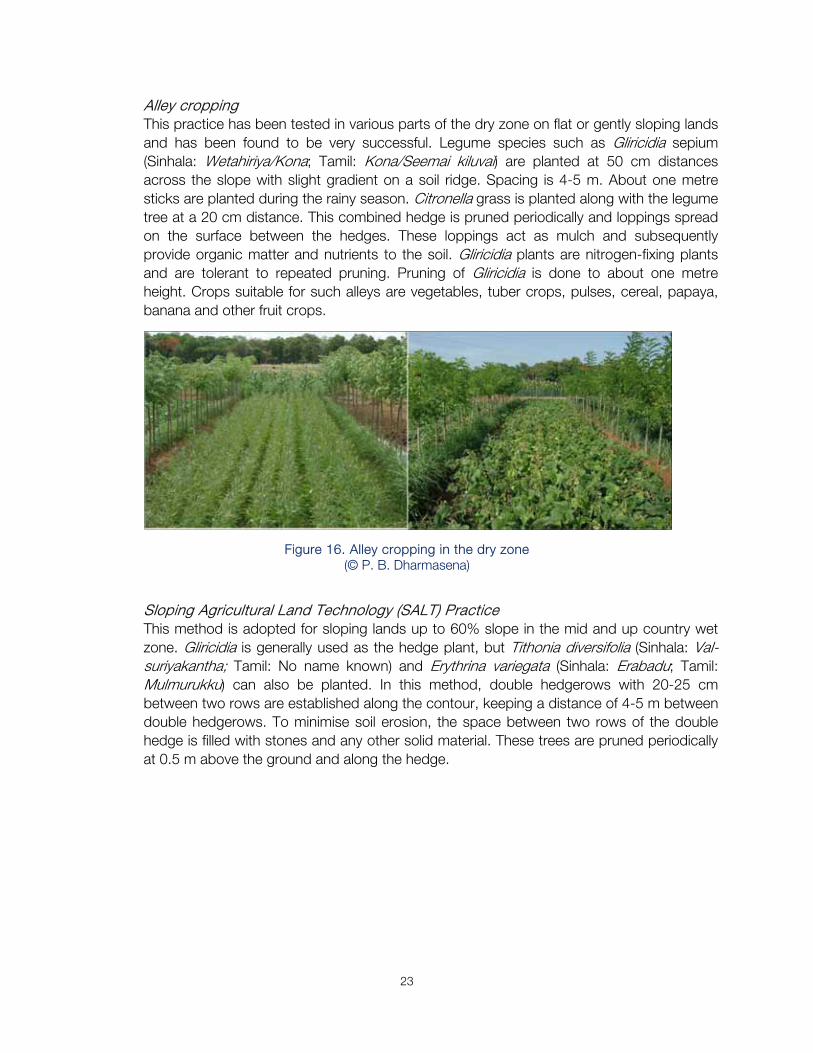
Alley cropping This practice has been tested in various parts of the dry zone on flat or gently sloping lands and has been found to be very successful. Legume species such as Gliricidia sepium (Sinhala: Wetahiriya/Kona; Tamil: Kona/Seemai kiluvai) are planted at 50 cm distances across the slope with slight gradient on a soil ridge. Spacing is 4-5 m. About one metre sticks are planted during the rainy season. Citronella grass is planted along with the legume tree at a 20 cm distance. This combined hedge is pruned periodically and loppings spread on the surface between the hedges. These loppings act as mulch and subsequently provide organic matter and nutrients to the soil. Gliricidia plants are nitrogen-fixing plants and are tolerant to repeated pruning. Pruning of Gliricidia is done to about one metre height. Crops suitable for such alleys are vegetables, tuber crops, pulses, cereal, papaya, banana and other fruit crops.
Figure 16. Alley cropping in the dry zone (© P. B. Dharmasena)
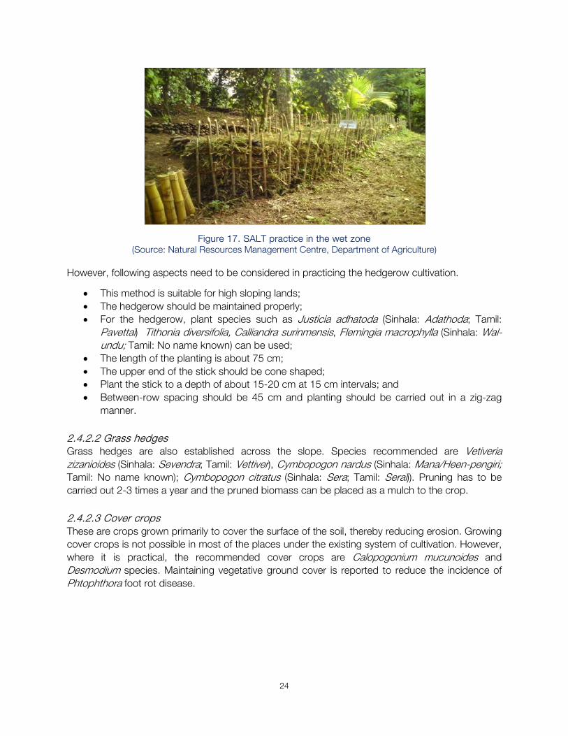
Sloping Agricultural Land Technology (SALT) Practice This method is adopted for sloping lands up to 60% slope in the mid and up country wet zone. Gliricidia is generally used as the hedge plant, but Tithonia diversifolia (Sinhala: Val-suriyakantha; Tamil: No name known) and Erythrina variegata (Sinhala: Erabadu; Tamil: Mulmurukku) can also be planted. In this method, double hedgerows with 20-25 cm between two rows are established along the contour, keeping a distance of 4-5 m between double hedgerows. To minimise soil erosion, the space between two rows of the double hedge is filled with stones and any other solid material. These trees are pruned periodically at 0.5 m above the ground and along the hedge.
24
Figure 17. SALT practice in the wet zone (Source: Natural Resources Management Centre, Department of Agriculture)
However, following aspects need to be considered in practicing the hedgerow cultivation.
This method is suitable for high sloping lands; The hedgerow should be maintained properly; For the hedgerow, plant species such as Justicia adhatoda (Sinhala: Adathoda; Tamil:
Pavettai) Tithonia diversifolia, Calliandra surinmensis, Flemingia macrophylla (Sinhala: Wal-undu; Tamil: No name known) can be used;
The length of the planting is about 75 cm; The upper end of the stick should be cone shaped; Plant the stick to a depth of about 15-20 cm at 15 cm intervals; and Between-row spacing should be 45 cm and planting should be carried out in a zig-zag
manner.
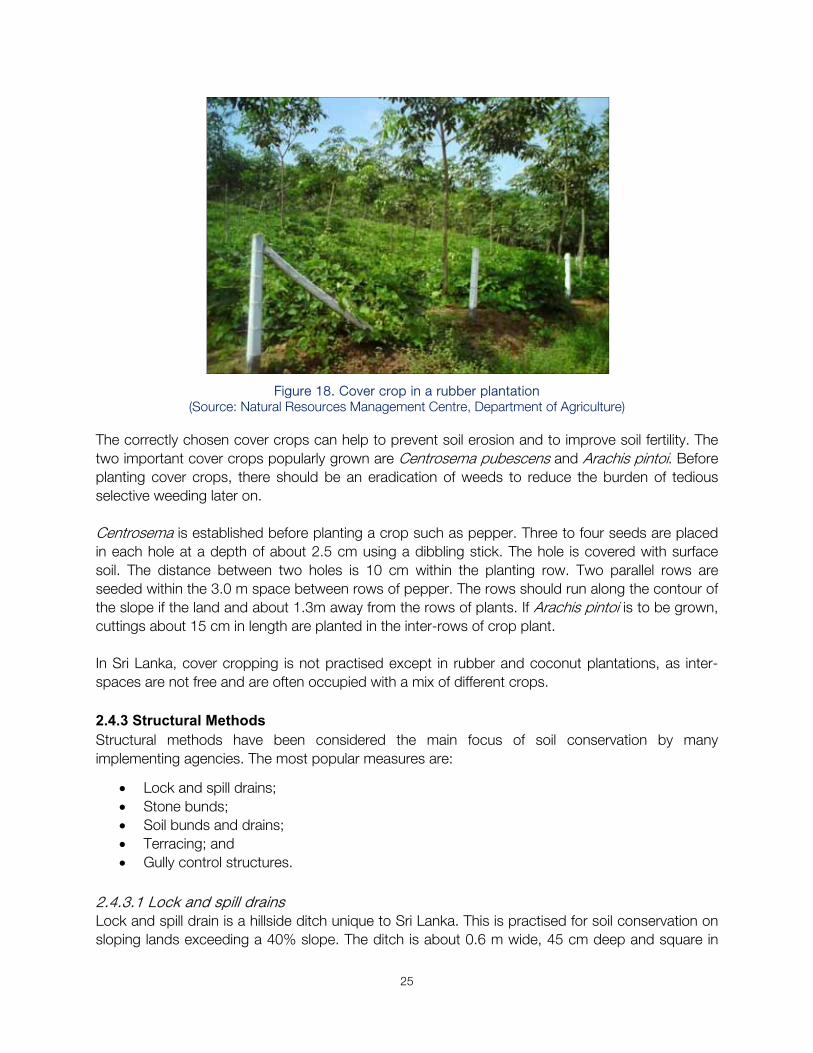
2.4.2.2 Grass hedges Grass hedges are also established across the slope. Species recommended are Vetiveria zizanioides (Sinhala: Sevendra; Tamil: Vettiver), Cymbopogon nardus (Sinhala: Mana/Heen-pengiri; Tamil: No name known); Cymbopogon citratus (Sinhala: Sera; Tamil: Serai)). Pruning has to be carried out 2-3 times a year and the pruned biomass can be placed as a mulch to the crop. 2.4.2.3 Cover crops These are crops grown primarily to cover the surface of the soil, thereby reducing erosion. Growing cover crops is not possible in most of the places under the existing system of cultivation. However, where it is practical, the recommended cover crops are Calopogonium mucunoides and Desmodium species. Maintaining vegetative ground cover is reported to reduce the incidence of Phtophthora foot rot disease.
25
Figure 18. Cover crop in a rubber plantation
(Source: Natural Resources Management Centre, Department of Agriculture)
The correctly chosen cover crops can help to prevent soil erosion and to improve soil fertility. The two important cover crops popularly grown are Centrosema pubescens and Arachis pintoi. Before planting cover crops, there should be an eradication of weeds to reduce the burden of tedious selective weeding later on. Centrosema is established before planting a crop such as pepper. Three to four seeds are placed in each hole at a depth of about 2.5 cm using a dibbling stick. The hole is covered with surface soil. The distance between two holes is 10 cm within the planting row. Two parallel rows are seeded within the 3.0 m space between rows of pepper. The rows should run along the contour of the slope if the land and about 1.3m away from the rows of plants. If Arachis pintoi is to be grown, cuttings about 15 cm in length are planted in the inter-rows of crop plant. In Sri Lanka, cover cropping is not practised except in rubber and coconut plantations, as inter-spaces are not free and are often occupied with a mix of different crops. 2.4.3 Structural Methods Structural methods have been considered the main focus of soil conservation by many implementing agencies. The most popular measures are:
Lock and spill drains; Stone bunds; Soil bunds and drains; Terracing; and Gully control structures.
2.4.3.1 Lock and spill drains Lock and spill drain is a hillside ditch unique to Sri Lanka. This is practised for soil conservation on sloping lands exceeding a 40% slope. The ditch is about 0.6 m wide, 45 cm deep and square in
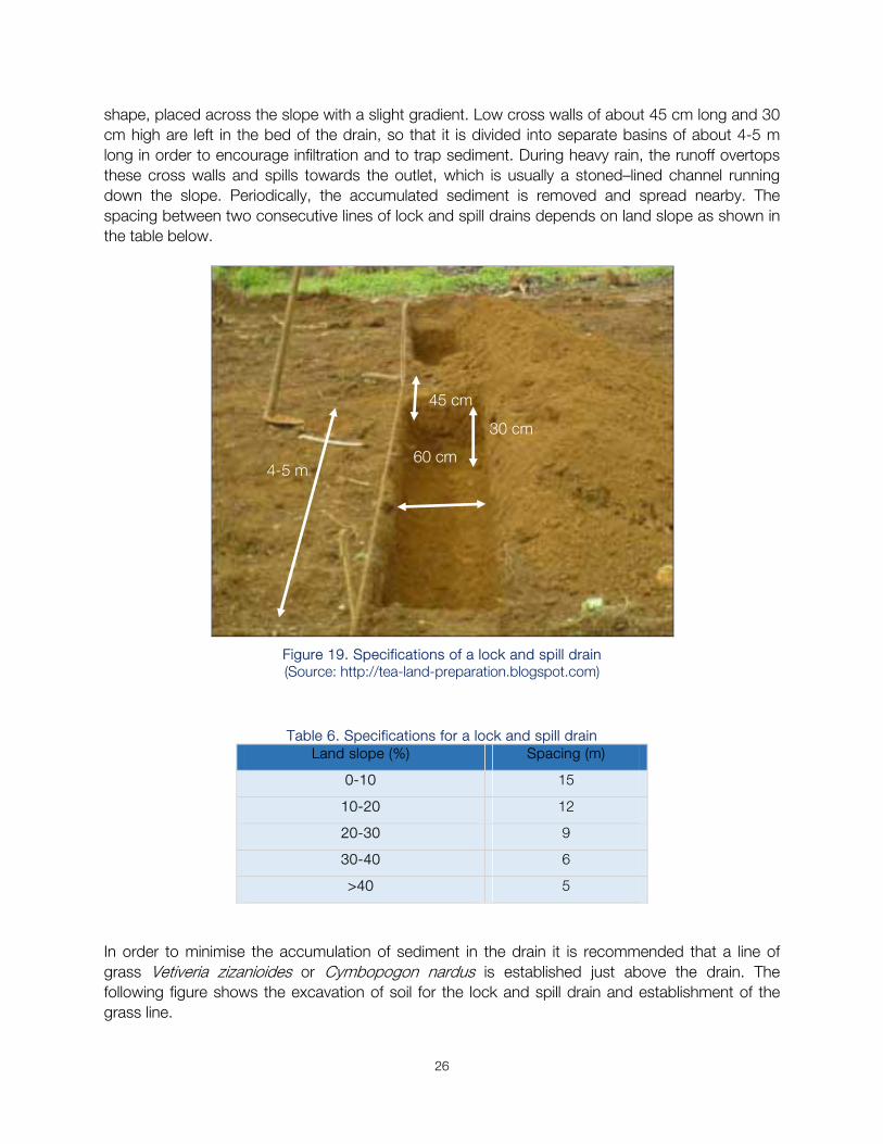
26
shape, placed across the slope with a slight gradient. Low cross walls of about 45 cm long and 30 cm high are left in the bed of the drain, so that it is divided into separate basins of about 4-5 m long in order to encourage infiltration and to trap sediment. During heavy rain, the runoff overtops these cross walls and spills towards the outlet, which is usually a stoned–lined channel running down the slope. Periodically, the accumulated sediment is removed and spread nearby. The spacing between two consecutive lines of lock and spill drains depends on land slope as shown in the table below.
Figure 19. Specifications of a lock and spill drain (Source: http://tea-land-preparation.blogspot.com)
Table 6. Specifications for a lock and spill drain
Land slope (%) Spacing (m)
0-10 15
10-20 12
20-30 9
30-40 6
>40 5
In order to minimise the accumulation of sediment in the drain it is recommended that a line of grass Vetiveria zizanioides or Cymbopogon nardus is established just above the drain. The following figure shows the excavation of soil for the lock and spill drain and establishment of the grass line.
45 cm
30 cm
4-5 m 60 cm
27
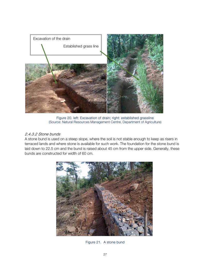
Figure 20. left: Excavation of drain; right: established grassline (Source: Natural Resources Management Centre, Department of Agriculture)
2.4.3.2 Stone bunds A stone bund is used on a steep slope, where the soil is not stable enough to keep as risers in terraced lands and where stone is available for such work. The foundation for the stone bund is laid down to 22.5 cm and the bund is raised about 45 cm from the upper side. Generally, these bunds are constructed for width of 60 cm.
Figure 21. A stone bund
Excavation of the drain
Established grass line
28
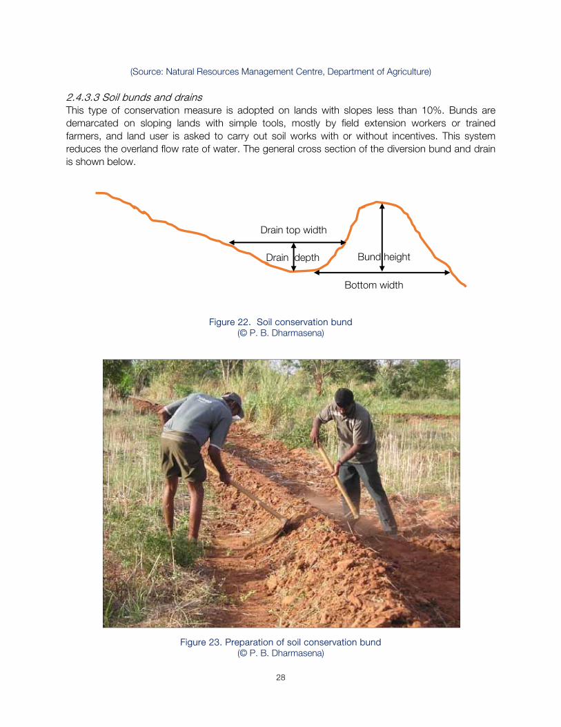
(Source: Natural Resources Management Centre, Department of Agriculture) 2.4.3.3 Soil bunds and drains This type of conservation measure is adopted on lands with slopes less than 10%. Bunds are demarcated on sloping lands with simple tools, mostly by field extension workers or trained farmers, and land user is asked to carry out soil works with or without incentives. This system reduces the overland flow rate of water. The general cross section of the diversion bund and drain is shown below.
Figure 22. Soil conservation bund (© P. B. Dharmasena)
Figure 23. Preparation of soil conservation bund (© P. B. Dharmasena)
Drain depth
Bottom width
Bund height
Drain top width
29
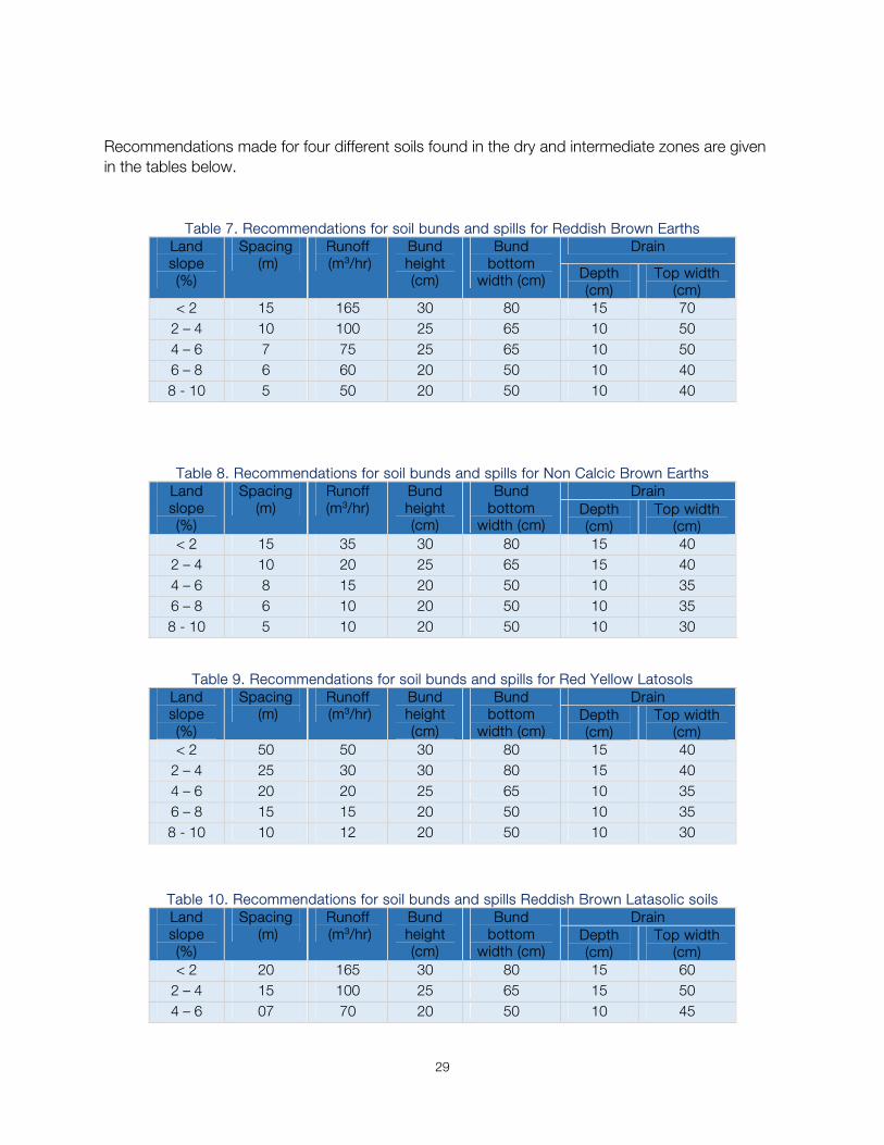
Recommendations made for four different soils found in the dry and intermediate zones are given in the tables below.
Table 7. Recommendations for soil bunds and spills for Reddish Brown Earths Land slope (%)
Spacing (m)
Runoff (m3/hr)
Bund height (cm)
Bund bottom
width (cm)
Drain
Depth (cm)
Top width (cm)
< 2 15 165 30 80 15 70 2 – 4 10 100 25 65 10 50 4 – 6 7 75 25 65 10 50 6 – 8 6 60 20 50 10 40 8 - 10 5 50 20 50 10 40
Table 8. Recommendations for soil bunds and spills for Non Calcic Brown Earths
Land slope (%)
Spacing (m)
Runoff(m3/hr)
Bund height (cm)
Bund bottom
width (cm)
Drain Depth (cm)
Top width (cm)
< 2 15 35 30 80 15 40 2 – 4 10 20 25 65 15 40 4 – 6 8 15 20 50 10 35 6 – 8 6 10 20 50 10 35 8 - 10 5 10 20 50 10 30
Table 9. Recommendations for soil bunds and spills for Red Yellow Latosols Land slope (%)
Spacing (m)
Runoff (m3/hr)
Bund height (cm)
Bund bottom
width (cm)
Drain Depth (cm)
Top width (cm)
< 2 50 50 30 80 15 40 2 – 4 25 30 30 80 15 40 4 – 6 20 20 25 65 10 35 6 – 8 15 15 20 50 10 35 8 - 10 10 12 20 50 10 30
Table 10. Recommendations for soil bunds and spills Reddish Brown Latasolic soils Land slope (%)
Spacing (m)
Runoff (m3/hr)
Bund height (cm)
Bund bottom
width (cm)
Drain Depth (cm)
Top width(cm)
< 2 20 165 30 80 15 60 2 – 4 15 100 25 65 15 50 4 – 6 07 70 20 50 10 45
30
6 – 8 06 60 20 50 08 40 8 - 10 05 50 15 40 07 35
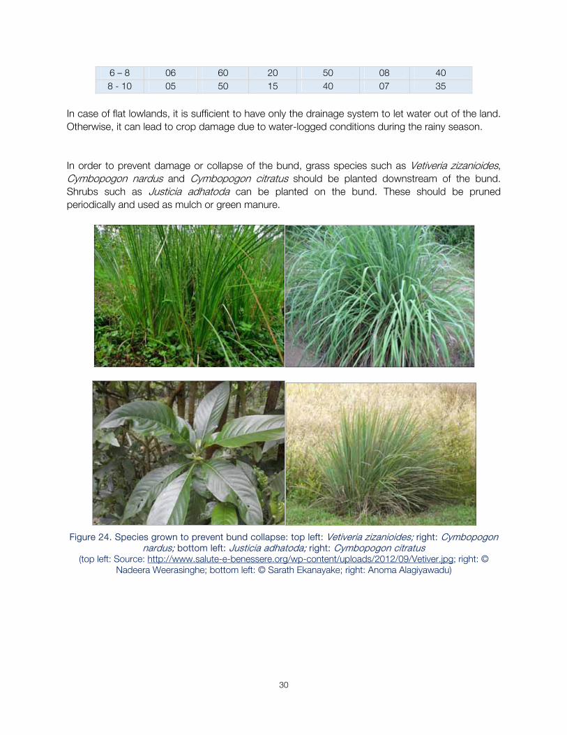
In case of flat lowlands, it is sufficient to have only the drainage system to let water out of the land. Otherwise, it can lead to crop damage due to water-logged conditions during the rainy season. In order to prevent damage or collapse of the bund, grass species such as Vetiveria zizanioides, Cymbopogon nardus and Cymbopogon citratus should be planted downstream of the bund. Shrubs such as Justicia adhatoda can be planted on the bund. These should be pruned periodically and used as mulch or green manure.
Figure 24. Species grown to prevent bund collapse: top left: Vetiveria zizanioides; right: Cymbopogon
nardus; bottom left: Justicia adhatoda; right: Cymbopogon citratus (top left: Source: http://www.salute-e-benessere.org/wp-content/uploads/2012/09/Vetiver.jpg; right: ©
Nadeera Weerasinghe; bottom left: © Sarath Ekanayake; right: Anoma Alagiyawadu)
31
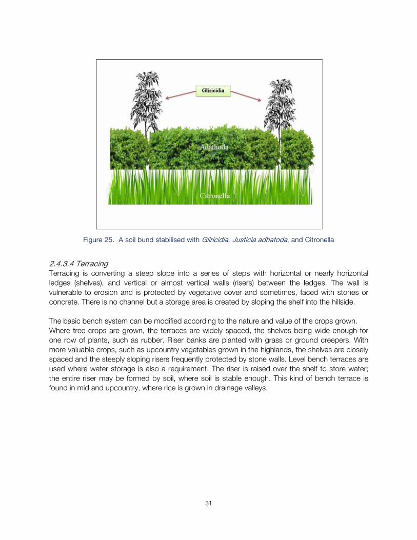
Figure 25. A soil bund stabilised with Gliricidia, Justicia adhatoda, and Citronella
2.4.3.4 Terracing Terracing is converting a steep slope into a series of steps with horizontal or nearly horizontal ledges (shelves), and vertical or almost vertical walls (risers) between the ledges. The wall is vulnerable to erosion and is protected by vegetative cover and sometimes, faced with stones or concrete. There is no channel but a storage area is created by sloping the shelf into the hillside. The basic bench system can be modified according to the nature and value of the crops grown. Where tree crops are grown, the terraces are widely spaced, the shelves being wide enough for one row of plants, such as rubber. Riser banks are planted with grass or ground creepers. With more valuable crops, such as upcountry vegetables grown in the highlands, the shelves are closely spaced and the steeply sloping risers frequently protected by stone walls. Level bench terraces are used where water storage is also a requirement. The riser is raised over the shelf to store water; the entire riser may be formed by soil, where soil is stable enough. This kind of bench terrace is found in mid and upcountry, where rice is grown in drainage valleys.
32
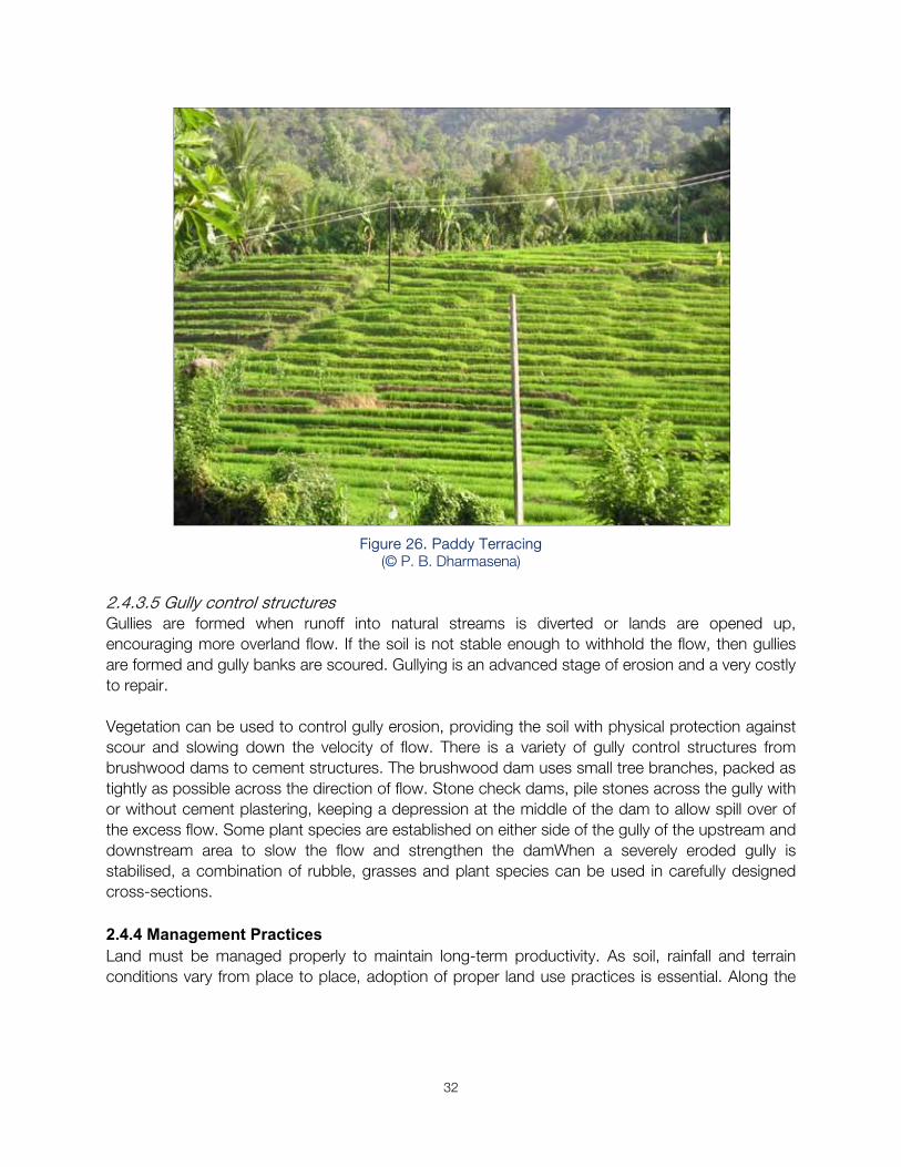
Figure 26. Paddy Terracing
(© P. B. Dharmasena)
2.4.3.5 Gully control structures Gullies are formed when runoff into natural streams is diverted or lands are opened up, encouraging more overland flow. If the soil is not stable enough to withhold the flow, then gullies are formed and gully banks are scoured. Gullying is an advanced stage of erosion and a very costly to repair. Vegetation can be used to control gully erosion, providing the soil with physical protection against scour and slowing down the velocity of flow. There is a variety of gully control structures from brushwood dams to cement structures. The brushwood dam uses small tree branches, packed as tightly as possible across the direction of flow. Stone check dams, pile stones across the gully with or without cement plastering, keeping a depression at the middle of the dam to allow spill over of the excess flow. Some plant species are established on either side of the gully of the upstream and downstream area to slow the flow and strengthen the damWhen a severely eroded gully is stabilised, a combination of rubble, grasses and plant species can be used in carefully designed cross-sections. 2.4.4 Management Practices Land must be managed properly to maintain long-term productivity. As soil, rainfall and terrain conditions vary from place to place, adoption of proper land use practices is essential. Along the
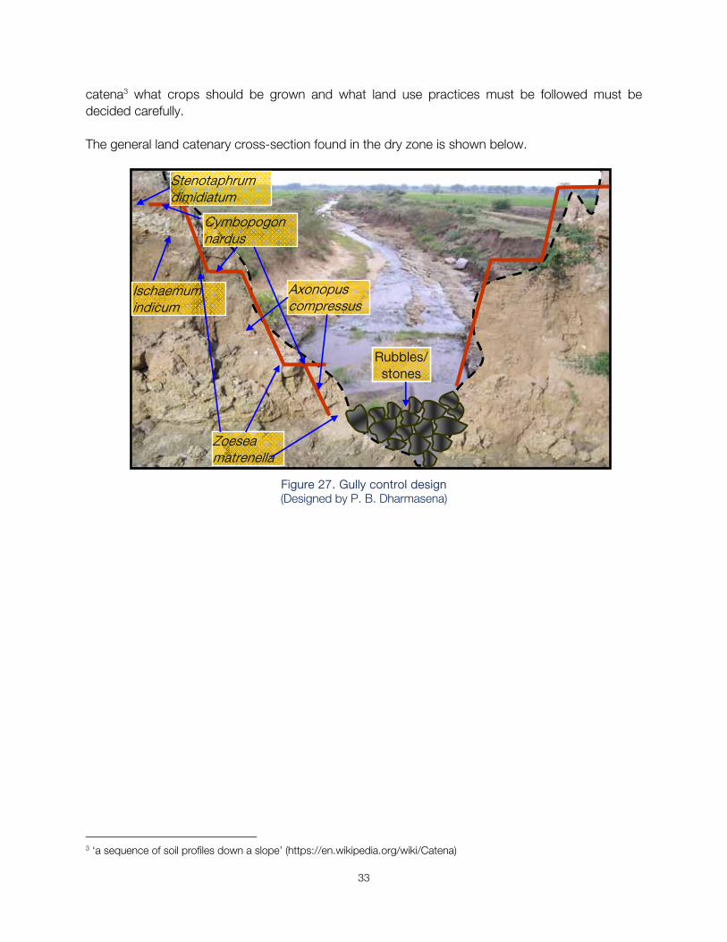
33
catena3 what crops should be grown and what land use practices must be followed must be decided carefully. The general land catenary cross-section found in the dry zone is shown below.
Figure 27. Gully control design (Designed by P. B. Dharmasena)
3 ‘a sequence of soil profiles down a slope’ (https://en.wikipedia.org/wiki/Catena)
Stenotaphrum dimidiatum
Zoesea matrenella
Cymbopogon nardus
Axonopus compressus
Ischaemum indicum
Rubbles/ stones
34
Well drained shallow
Moderately drained moderately deep
Imperfectly drained deep
Poorly drained deep
Land catenary positions
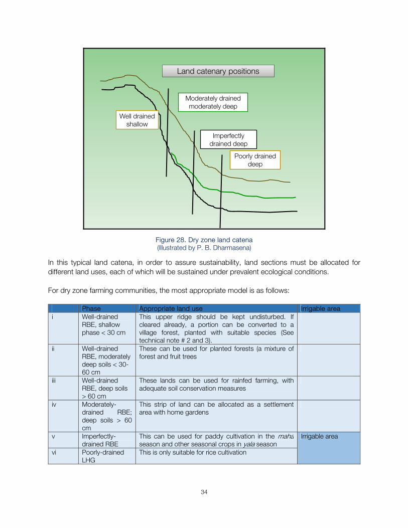
Figure 28. Dry zone land catena (Illustrated by P. B. Dharmasena)
In this typical land catena, in order to assure sustainability, land sections must be allocated for different land uses, each of which will be sustained under prevalent ecological conditions. For dry zone farming communities, the most appropriate model is as follows:
Phase Appropriate land use Irrigable areai Well-drained
RBE, shallow phase < 30 cm
This upper ridge should be kept undisturbed. If cleared already, a portion can be converted to a village forest, planted with suitable species (See technical note # 2 and 3).
ii Well-drained RBE, moderately deep soils < 30-60 cm
These can be used for planted forests (a mixture of forest and fruit trees
iii Well-drained RBE, deep soils > 60 cm
These lands can be used for rainfed farming, with adequate soil conservation measures
iv Moderately-drained RBE; deep soils > 60 cm
This strip of land can be allocated as a settlement area with home gardens
v Imperfectly-drained RBE
This can be used for paddy cultivation in the maha season and other seasonal crops in yala season
Irrigable area
vi Poorly-drained LHG
This is only suitable for rice cultivation
35
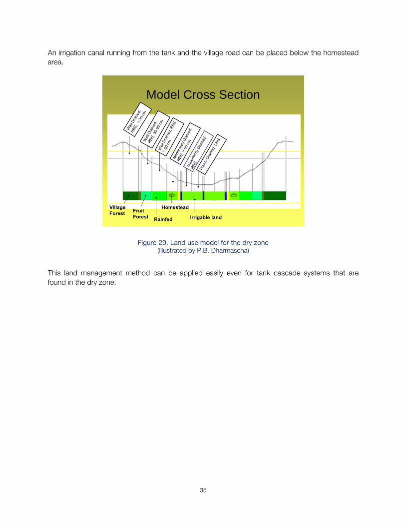
An irrigation canal running from the tank and the village road can be placed below the homestead area.
Model Cross Section
Village Forest Fruit
Forest Rainfed
Homestead
Irrigable land
Figure 29. Land use model for the dry zone (Illustrated by P.B. Dharmasena)
This land management method can be applied easily even for tank cascade systems that are found in the dry zone.
36
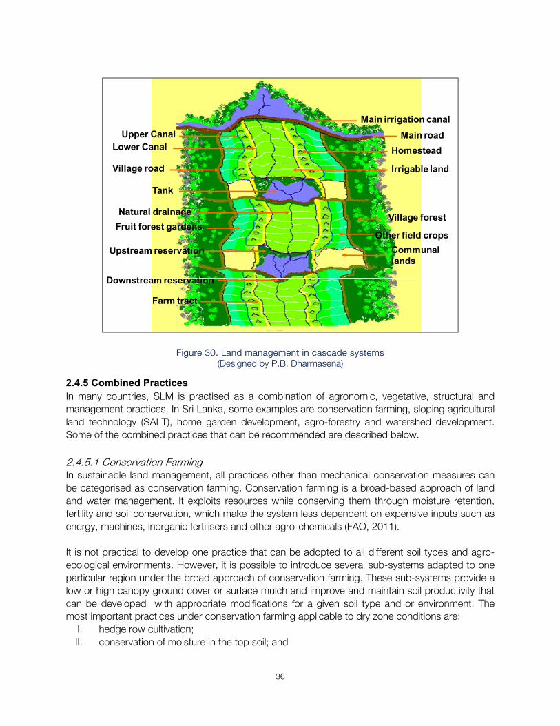
Main irrigation canal
Natural drainage
Irrigable land
Homestead
Other field crops
Village forest
Main road
Village road
Farm tract
Communal lands
Tank
Lower CanalUpper Canal
Fruit forest gardens
Upstream reservation
Downstream reservation
Figure 30. Land management in cascade systems
(Designed by P.B. Dharmasena)
2.4.5 Combined Practices In many countries, SLM is practised as a combination of agronomic, vegetative, structural and management practices. In Sri Lanka, some examples are conservation farming, sloping agricultural land technology (SALT), home garden development, agro-forestry and watershed development. Some of the combined practices that can be recommended are described below. 2.4.5.1 Conservation Farming In sustainable land management, all practices other than mechanical conservation measures can be categorised as conservation farming. Conservation farming is a broad-based approach of land and water management. It exploits resources while conserving them through moisture retention, fertility and soil conservation, which make the system less dependent on expensive inputs such as energy, machines, inorganic fertilisers and other agro-chemicals (FAO, 2011). It is not practical to develop one practice that can be adopted to all different soil types and agro-ecological environments. However, it is possible to introduce several sub-systems adapted to one particular region under the broad approach of conservation farming. These sub-systems provide a low or high canopy ground cover or surface mulch and improve and maintain soil productivity that can be developed with appropriate modifications for a given soil type and or environment. The most important practices under conservation farming applicable to dry zone conditions are:
I. hedge row cultivation; II. conservation of moisture in the top soil; and
37
III. soil fertility enhancement
Hedgerow Cultivation This practice is known as avenue or alley cropping in the dry zone and SALT (Sloping Agricultural Land Technology) in the up and mid country wet zone. In addition to soil conservation, these practices provide green manure for the land as well as fuel wood for domestic use. Alley cropping See under vegetative methods. SALT Practice See under vegetative methods. Conservation of moisture in the top soil Seasonal crops use moisture available in the top soil within first 30 cm. This soil moisture is lost easily through evaporation and transpiration. Mulching and shading are the most suitable strategies to prevent this moisture loss. In-situ rainwater harvesting methods can be used to make the top soil layer moist during dry periods. Mulching Rice and grass straw, weed trash and fallen leaves can be used as mulch to cover the surface. These mulching materials can be placed along plant rows or around fruit trees to minimise moisture loss from soil. This practice is suitable for crops such as vegetables, cereals, pulses, tuber crops. Mulching is easier if crops are planted in rows. When mulching is carried out before planting, seeds can be placed on mulched lands with a pointed stick or fork at the desired distance. Mulching can be used to control weeds. While conserving moisture, the mulch will enhance microbial activities. It protects soil and controls soil erosion, while increasing the moisture holding capacity of soil. Mulching lowers the soil temperature, reduces the soil pH and maintains uniform soil moisture in the root environment. In-situ rainwater harvesting How much rainfall can be absorbed by the soil is determined by various factors such as the infiltration rate, intensity of rainfall, soil moisture holding capacity. There are practices developed to enhance the opportunity to absorb a greater part of the rainfall or runoff. All these practices are referred to as in-situ rainwater harvesting. In these methods, in addition to direct rainfall, runoff water is diverted to a point where it can be stored for some period and released slowly to the root zone, when the soil dries. Crescent, V, U or eyebrow shaped4 small earth bunds are prepared (whichever appropriate) to divert runoff to a point of interest. Runoff is collected by this point in a porous soil pit
4 semicircular bunds
38
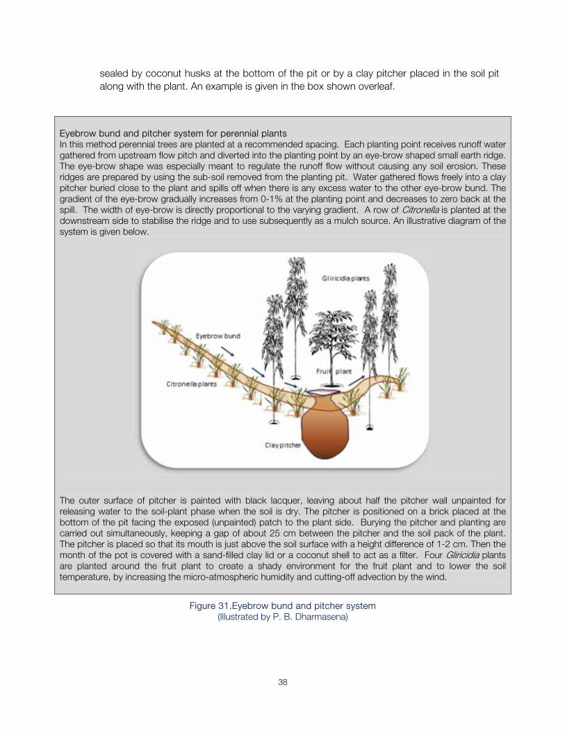
sealed by coconut husks at the bottom of the pit or by a clay pitcher placed in the soil pit along with the plant. An example is given in the box shown overleaf.
Eyebrow bund and pitcher system for perennial plants In this method perennial trees are planted at a recommended spacing. Each planting point receives runoff water gathered from upstream flow pitch and diverted into the planting point by an eye-brow shaped small earth ridge. The eye-brow shape was especially meant to regulate the runoff flow without causing any soil erosion. These ridges are prepared by using the sub-soil removed from the planting pit. Water gathered flows freely into a clay pitcher buried close to the plant and spills off when there is any excess water to the other eye-brow bund. The gradient of the eye-brow gradually increases from 0-1% at the planting point and decreases to zero back at the spill. The width of eye-brow is directly proportional to the varying gradient. A row of Citronella is planted at the downstream side to stabilise the ridge and to use subsequently as a mulch source. An illustrative diagram of the system is given below.
The outer surface of pitcher is painted with black lacquer, leaving about half the pitcher wall unpainted for releasing water to the soil-plant phase when the soil is dry. The pitcher is positioned on a brick placed at the bottom of the pit facing the exposed (unpainted) patch to the plant side. Burying the pitcher and planting are carried out simultaneously, keeping a gap of about 25 cm between the pitcher and the soil pack of the plant. The pitcher is placed so that its mouth is just above the soil surface with a height difference of 1-2 cm. Then the month of the pot is covered with a sand-filled clay lid or a coconut shell to act as a filter. Four Gliricidia plants are planted around the fruit plant to create a shady environment for the fruit plant and to lower the soil temperature, by increasing the micro-atmospheric humidity and cutting-off advection by the wind.
Figure 31.Eyebrow bund and pitcher system (Illustrated by P. B. Dharmasena)
39
2.4.5.2 Soil fertility enhancement If the fertility of soil is high chemically, physically and biologically, then soil erodibility can be reduced to a minimum, with the formation of a stable aggregate, and erosion can be reduced with the rapid formation of a healthy vegetative cover. This situation can minimise the erosional effect of overland flow. Thus, soil fertility enhancement is considered a soil conservation measure.
Soil fertility can be improved by adding various types of fertiliser sources containing plant nutrients such as inorganic fertiliser, animal manure, green manure, compost, liquid fertiliser.
There are 16 essential nutrients for plant growth. These include the six primary nutrients (C, H, O, N, P, K); three secondary nutrients (Ca, Mg, S) and seven micro-nutrients (Fe, Zn, Mn, Cu, B, Mo, Cl). Of the primary nutrients C, H and O can be obtained from air and water; while N, P and K can be provided by applying fertiliser. The Department of Agriculture has made recommendations of suitable N, P and K fertiliser rates and frequencies for different crops. These recommendations are not included in this technical note, but can be obtained from Agricultural Instructors of the area.
It should be noted that chemical fertilisers do not provide the crop requirement of all nutrients. Further, the continuous use of chemical fertilisers can destroy the soil structure, turn the soil acidic and bring about nutrient imbalances resulting in nutrient interactions. Most importantly, the organic matter in the soil does not improve with application of chemical fertilisers, resulting in erosion and loss of top soil.
Many materials that are organic in nature are suitable for soil fertility enhancement. Materials that can be used are classified into:
Plant residues: crop residues and green manure; Animal wastes: animal manure and slaughter house wastes; and Compost: consists of both plant and animal materials, which are wastes of various origin.
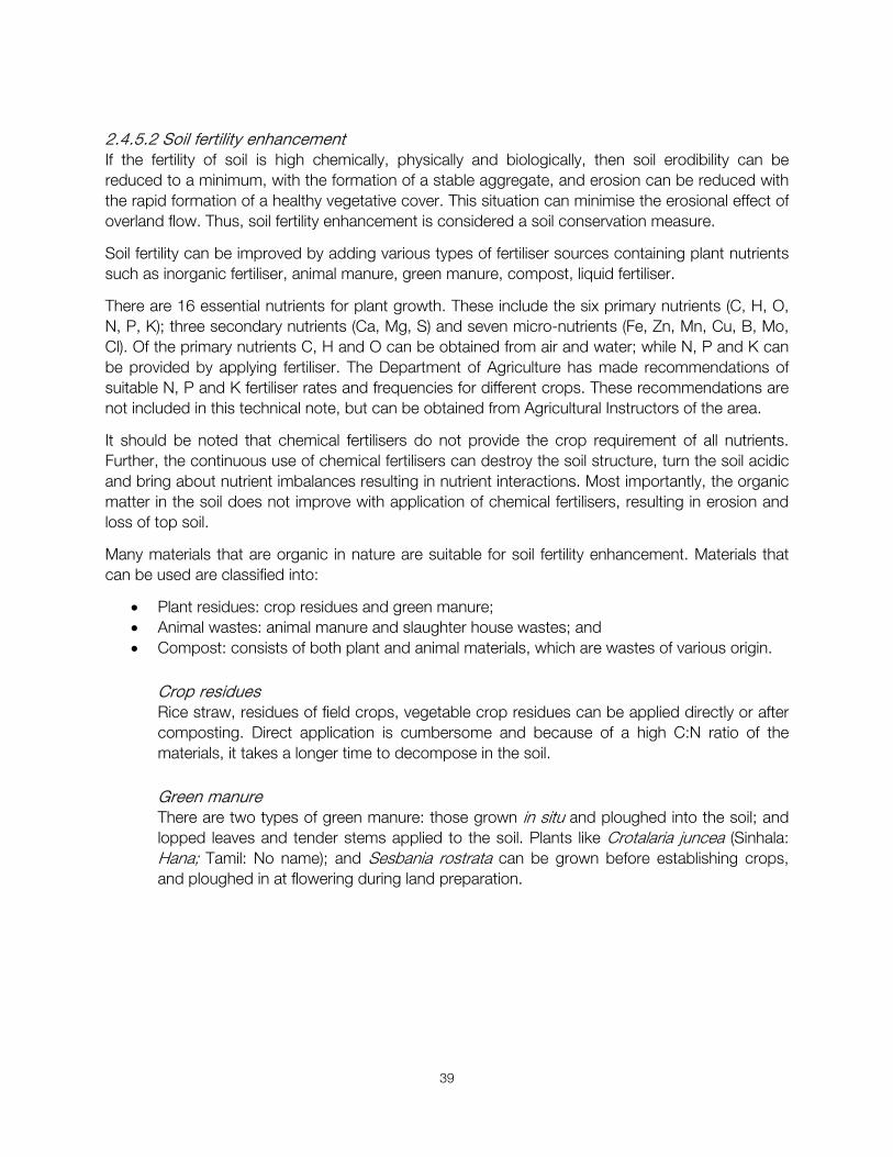
Crop residues Rice straw, residues of field crops, vegetable crop residues can be applied directly or after composting. Direct application is cumbersome and because of a high C:N ratio of the materials, it takes a longer time to decompose in the soil. Green manure There are two types of green manure: those grown in situ and ploughed into the soil; and lopped leaves and tender stems applied to the soil. Plants like Crotalaria juncea (Sinhala: Hana; Tamil: No name); and Sesbania rostrata can be grown before establishing crops, and ploughed in at flowering during land preparation.
40
Figure 32. Species suitable for green manure: left: Crotalaria juncea; right: Sesbania rostrata
(Source: left: https://www.flickr.com/photos/plj/7158672856; right: http://www.tropicalforages.info/key/Forages/Media/Html/Sesbania_rostrata.htm)
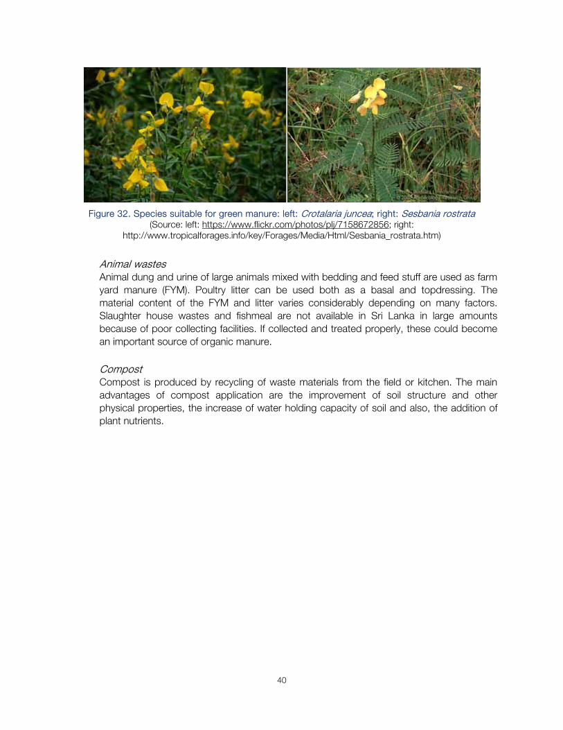
Animal wastes Animal dung and urine of large animals mixed with bedding and feed stuff are used as farm yard manure (FYM). Poultry litter can be used both as a basal and topdressing. The material content of the FYM and litter varies considerably depending on many factors. Slaughter house wastes and fishmeal are not available in Sri Lanka in large amounts because of poor collecting facilities. If collected and treated properly, these could become an important source of organic manure. Compost Compost is produced by recycling of waste materials from the field or kitchen. The main advantages of compost application are the improvement of soil structure and other physical properties, the increase of water holding capacity of soil and also, the addition of plant nutrients.
41
Compost preparation methods A shady place is suitable for making compost. The pit or heap method can be adopted. The pit method is generally recommended for the dry zone and heap method for the wet zone.
Pit method A pit of 1.6 m long, 1 m wide and 1.2 m deep is excavated and kept for about one week. Large wood sticks are placed at the bottom and small sticks on the top of it. An 8-10 cm thick layer of easily decomposable organic materials such as Gliricidia sepium Justicia adhatoda (Sinhala: Tithonia diversifolia, Eichhornia crassipes, dried grasses and vegetable refuse is placed on top after these are cut into small pieces and trampled to get rid of trapped air. Then, cow dung, in liquid form, is applied uniformly over. Several such layers are added to a height 40-50 cm and finally the top is plastered with a thin layer of mud to provide anaerobic conditions. After keeping the mixture for two weeks, the material is mixed thoroughly with a mammoty at two week intervals to accelerate the natural decomposing process. The entire pit should be covered to prevent the mixture being exposed to rain. The process of composting could be completed in about three months. Addition of leaf litter and top soil collected from the forest enhances microbial activities within the mixture. Heap method A land plot of 2-3 m long and 1.5-2.5 m wide is adequate for the heap space. All procedures explained under the pit method can be adopted here. It may be desirable to insert a tube and pour water into it, to accelerate the decomposing rate.
Figure 33. Two methods of compost preparation (© P.B. Dharmasena)
2.4.6 Cost of Structural Methods In constructing various structural measures for SLM, farmers cannot bear the total cost and the project needs to consider some incentives to be given based on the cost construction. The table below provides the recommended cost rates by the Department of Agriculture.
42
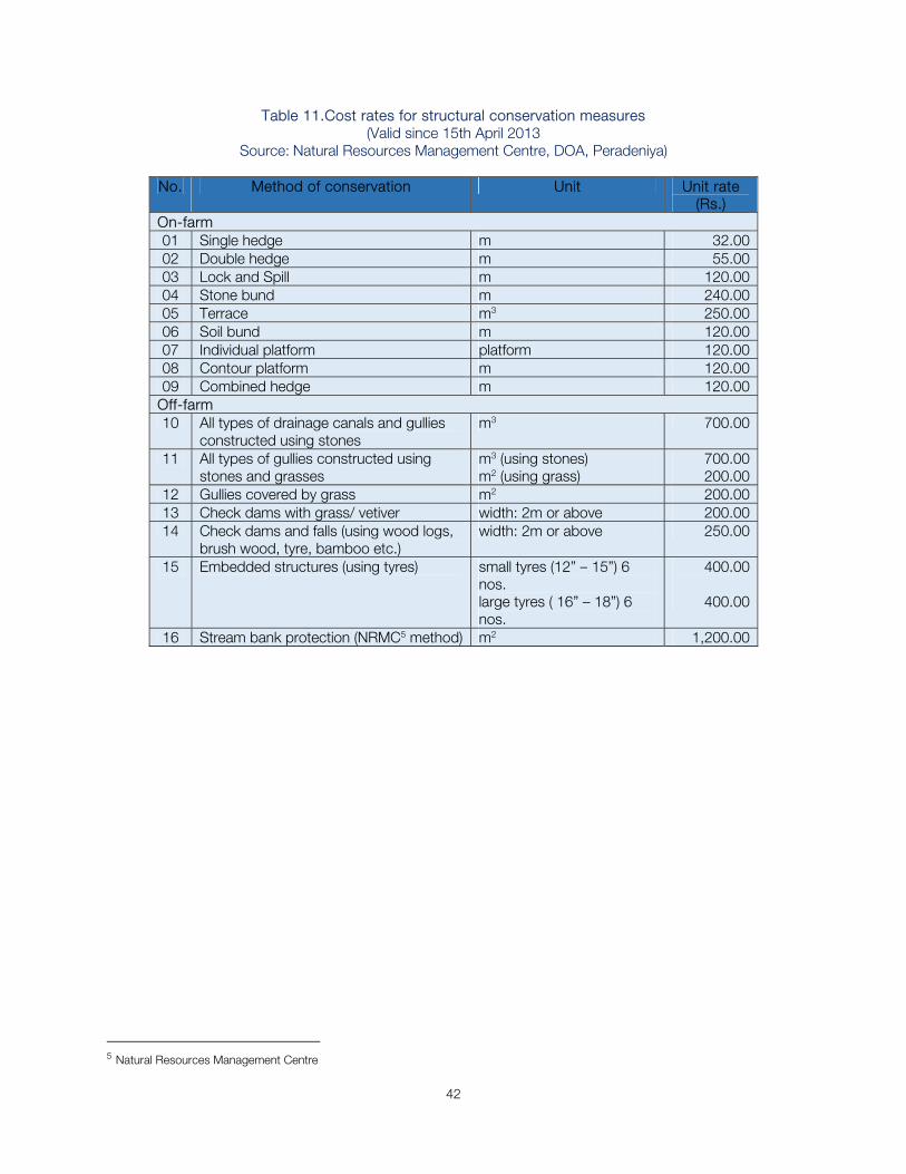
Table 11.Cost rates for structural conservation measures (Valid since 15th April 2013
Source: Natural Resources Management Centre, DOA, Peradeniya)
No. Method of conservation Unit Unit rate (Rs.)
On-farm 01 Single hedge m 32.0002 Double hedge m 55.0003 Lock and Spill m 120.0004 Stone bund m 240.0005 Terrace m3 250.0006 Soil bund m 120.0007 Individual platform platform 120.0008 Contour platform m 120.0009 Combined hedge m 120.00
Off-farm 10 All types of drainage canals and gullies
constructed using stones m3 700.00
11 All types of gullies constructed using stones and grasses
m3 (using stones)m2 (using grass)
700.00200.00
12 Gullies covered by grass m2 200.0013 Check dams with grass/ vetiver width: 2m or above 200.0014 Check dams and falls (using wood logs,
brush wood, tyre, bamboo etc.) width: 2m or above 250.00
15 Embedded structures (using tyres) small tyres (12” – 15”) 6 nos. large tyres ( 16” – 18”) 6 nos.
400.00
400.00
16 Stream bank protection (NRMC5 method) m2 1,200.00
5 Natural Resources Management Centre
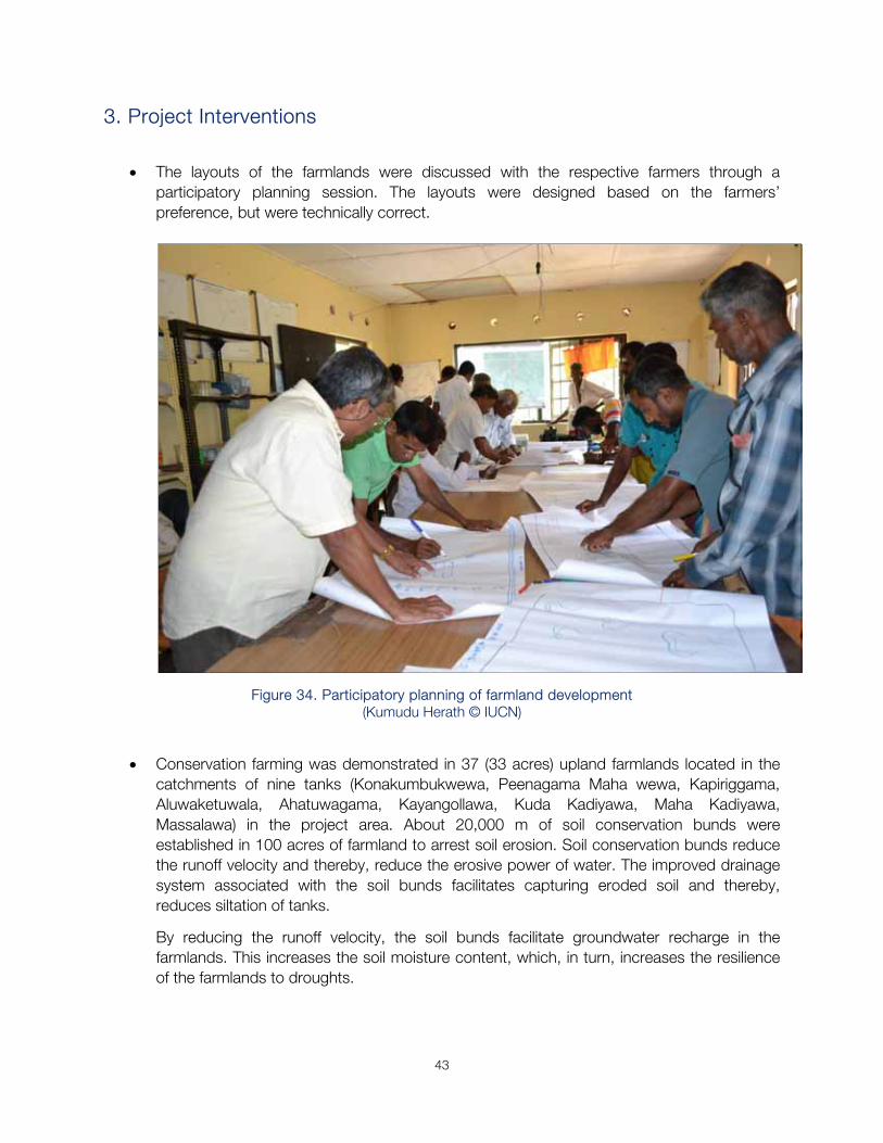
43
3. Project Interventions
The layouts of the farmlands were discussed with the respective farmers through a participatory planning session. The layouts were designed based on the farmers’ preference, but were technically correct.
Figure 34. Participatory planning of farmland development (Kumudu Herath © IUCN)
Conservation farming was demonstrated in 37 (33 acres) upland farmlands located in the
catchments of nine tanks (Konakumbukwewa, Peenagama Maha wewa, Kapiriggama, Aluwaketuwala, Ahatuwagama, Kayangollawa, Kuda Kadiyawa, Maha Kadiyawa, Massalawa) in the project area. About 20,000 m of soil conservation bunds were established in 100 acres of farmland to arrest soil erosion. Soil conservation bunds reduce the runoff velocity and thereby, reduce the erosive power of water. The improved drainage system associated with the soil bunds facilitates capturing eroded soil and thereby, reduces siltation of tanks.
By reducing the runoff velocity, the soil bunds facilitate groundwater recharge in the farmlands. This increases the soil moisture content, which, in turn, increases the resilience of the farmlands to droughts.
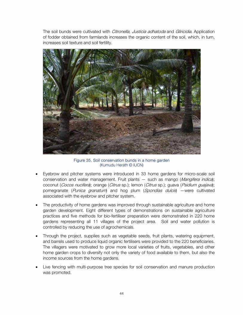
44
The soil bunds were cultivated with Citronella, Justicia adhatoda and Gliricidia. Application of fodder obtained from farmlands increases the organic content of the soil, which, in turn, increases soil texture and soil fertility.
Figure 35. Soil conservation bunds in a home garden (Kumudu Herath © IUCN)
Eyebrow and pitcher systems were introduced in 33 home gardens for micro-scale soil conservation and water management. Fruit plants — such as mango (Mangifera indica); coconut (Cocos nucifera); orange (Citrus sp.); lemon (Citrus sp.); guava (Psidium guajava); pomegranate (Punica granatum) and hog plum (Spondias dulcis) —were cultivated associated with the eyebrow and pitcher system.
The productivity of home gardens was improved through sustainable agriculture and home garden development. Eight different types of demonstrations on sustainable agriculture practices and five methods for bio-fertiliser preparation were demonstrated in 220 home gardens representing all 11 villages of the project area. Soil and water pollution is controlled by reducing the use of agrochemicals.
Through the project, supplies such as vegetable seeds, fruit plants, watering equipment, and barrels used to produce liquid organic fertilisers were provided to the 220 beneficiaries. The villagers were motivated to grow more local varieties of fruits, vegetables, and other home garden crops to diversify not only the variety of food available to them, but also the income sources from the home gardens.
Live fencing with multi-purpose tree species for soil conservation and manure production was promoted.
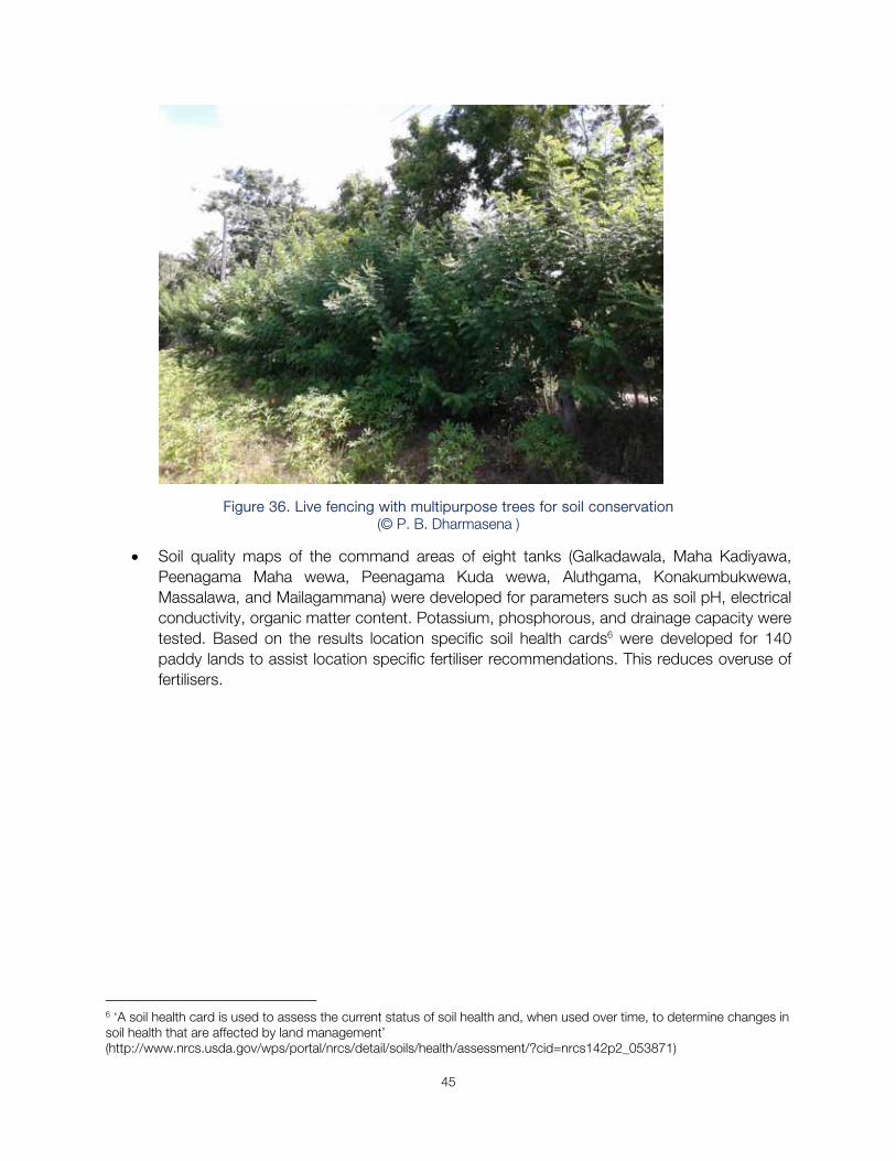
45
Figure 36. Live fencing with multipurpose trees for soil conservation (© P. B. Dharmasena )
Soil quality maps of the command areas of eight tanks (Galkadawala, Maha Kadiyawa, Peenagama Maha wewa, Peenagama Kuda wewa, Aluthgama, Konakumbukwewa, Massalawa, and Mailagammana) were developed for parameters such as soil pH, electrical conductivity, organic matter content. Potassium, phosphorous, and drainage capacity were tested. Based on the results location specific soil health cards6 were developed for 140 paddy lands to assist location specific fertiliser recommendations. This reduces overuse of fertilisers.
6 ‘A soil health card is used to assess the current status of soil health and, when used over time, to determine changes in soil health that are affected by land management’ (http://www.nrcs.usda.gov/wps/portal/nrcs/detail/soils/health/assessment/?cid=nrcs142p2_053871)
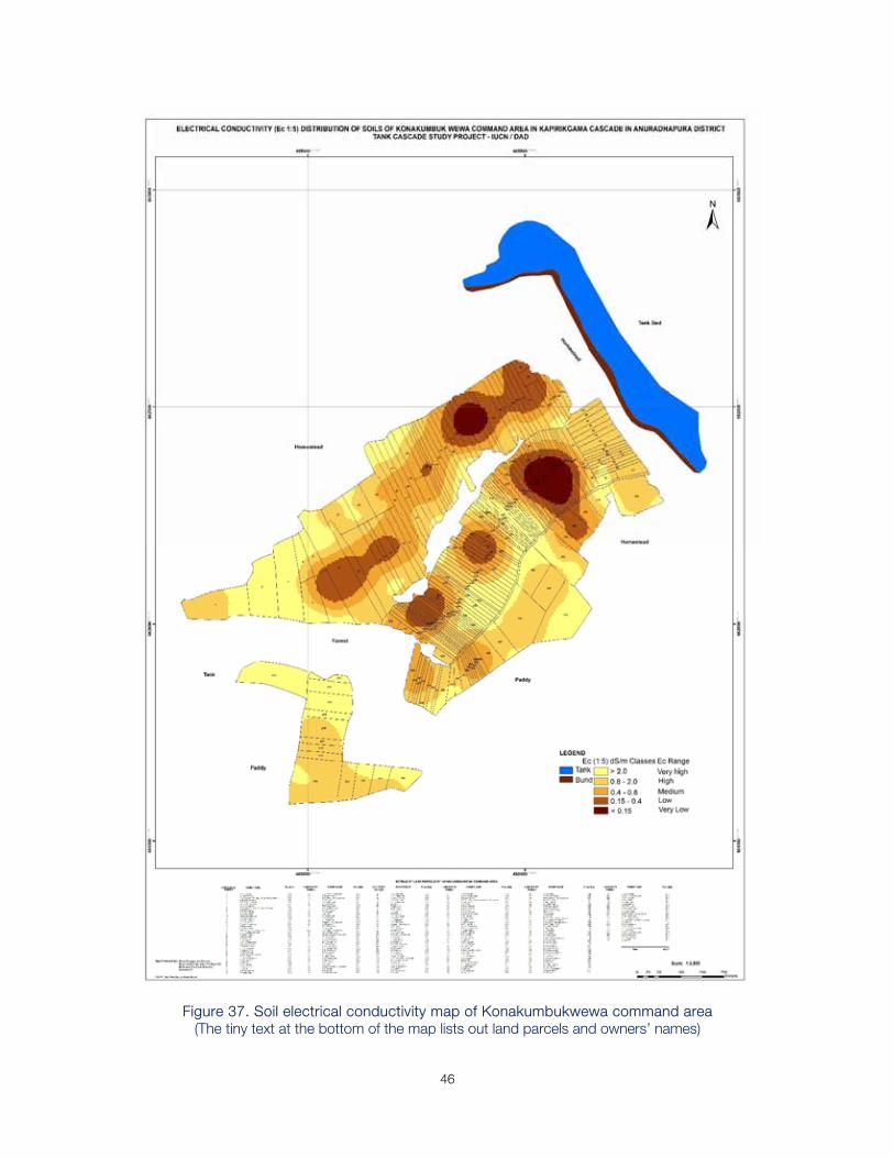
46
Figure 37. Soil electrical conductivity map of Konakumbukwewa command area (The tiny text at the bottom of the map lists out land parcels and owners’ names)
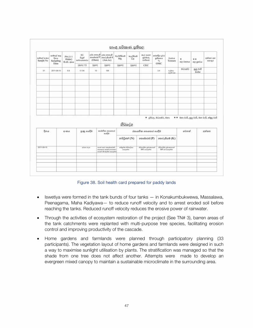
47
Figure 38. Soil health card prepared for paddy lands
Iswetiya were formed in the tank bunds of four tanks — in Konakumbukwewa, Massalawa, Peenagama, Maha Kadiyawa— to reduce runoff velocity and to arrest eroded soil before reaching the tanks. Reduced runoff velocity reduces the erosive power of rainwater.
Through the activities of ecosystem restoration of the project (See TN# 3), barren areas of the tank catchments were replanted with multi-purpose tree species, facilitating erosion control and improving productivity of the cascade.
Home gardens and farmlands were planned through participatory planning (33 participants). The vegetation layout of home gardens and farmlands were designed in such a way to maximise sunlight utilisation by plants. The stratification was managed so that the shade from one tree does not affect another. Attempts were made to develop an evergreen mixed canopy to maintain a sustainable microclimate in the surrounding area.
48
4. Recommendations for the Future
Continue establishing soil conservation bunds in the farmlands and home gardens in the immediate catchments of all the tanks in the cascade.
Establish iswetiya in all the tanks where it is technically possible.
Conduct soil quality testing and promote location-specific soil fertility programmes to minimise overuse of agrochemicals.
Promote sustainable agriculture and home garden development in the entire cascade area.
49
Citations
Basnayake, B. R. S. B.; Fernando, T. K. and J. C. Vithanage (2002). Variation of air temperature and rainfall during Yala and Maha agricultural seasons. Proceedings of the 58th Annual Session of Sri Lanka Association for the Advancement of Science (SLASS). Section E1. pp 212.
Blanco-Canqui, H. and L. Rattan (2008). Soil and water conservation. Pp 54-80 in Principles of soil conservation and management. Dordrecht: Springer.
Brady, N.C. (1974). The Nature and Properties of Soils. New York: MacMillan. 639 pp.
Chandrapala, L (1996). Long term trends of rainfall and temperature in Sri Lanka. Pp 153-162 in (eds.) Abrol, Y. P.; Gadgil, S. and G. B Pant Climate Variability and Agriculture. New Delhi, India: Narosa Publishing House. 372 pp.
Chandrapala, L. and T. K. Fernando (1995) Climate variability in Sri Lanka — a study of air temperature, rainfall and thunder activity. In: Proceedings of the International Symposium on Climate and Life in the Asia-Pacific, University of Brunei, Darussalam, 10-13 April, 1995.
Department of Census and Statistics (2016). Extent under Agriculture by Sector and by District – 2002. http://www.statistics.gov.lk/agriculture/AllSectors/index.htm Accessed Jan 12th 2016.
Department of Census and Statistics (2015). Paddy: Extent sown and harvested by irrigation scheme and season, 2006 - 2014. http://www.statistics.gov.lk/Abstract2015/CHAP5/5.3.pdf Accessed Jan 12th 2016.
Department of Census and Statistics (2002). Census of Agriculture, 2002. http://www.statistics.gov.lk/agriculture/AGC2002/AGC2002.htm Accessed Jan 24th 2016.
Department of Census and Statistics (1988). Census of Agriculture, 1988. Agricultural Statistics of Sri Lanka Colombo: Dept. of Census and Statistics. 105 pp.
Dharmasena, P.B (2003). Soil erosion and conservation – A case study in the dry zone of Sri Lanka. Tropical Agricultural Research and Extension, 6: 128-131.
Dharmasena, P. B (1992a). Soil erosion control measures for rainfed farming in the dry zone of Sri Lanka. Ph.D. Thesis, University of Peradeniya, Sri Lanka.
Dharmasena, P.B (1992b). Rainfall erosivity and potential erosion in the central dry zone. Trop. Agric. 148:111-120.
Eriyagama, N., Smakhtin, V., Chandrapala, L. and K. Fernando (2010). Impacts of climate change on water resources and agriculture in Sri Lanka: a review and preliminary vulnerability mapping. Colombo, Sri Lanka: International Water Management Institute. 51p. (IWMI Research Report 135). doi:10.5337/2010.211.
50
Esham, M. and C. Garforth (2013). Climate change and agricultural adaptation in Sri Lanka: a review. Climate and Development 5 (1). pp. 66-76. ISSN 1756-5537 doi:10.1080/17565529.2012.762333. Retrieved Sept 5th 2015.
FAO (2011). The State of the World’s Land and Water Resources for Food and Agriculture: managing systems at risk. Abingdon: FAO and Earthscan. 308 pp. http://www.fao.org/docrep/017/i1688e/i1688e.pdf Accessed Jan19th 2016.
Hewawasam, T., von Blanckenburg, F., Schaller, M. and P. Kubik (2003). Increase of human over natural erosion rates in tropical highlands constrained by cosmogenic nuclides. Geology: 31 (7); 597–600.
http://www.agrimin.gov.lk/web/index.php/en/project/12-project/26-promotion-of-production Accessed Jan 13th 2016.
http://www.doa.gov.lk/index.php/en/agro-parks/672 Accessed Jan 18th 2016.
https://en.wikipedia.org/wiki/Catena Accessed Jan 14th 2016.
https://en.wikipedia.org/wiki/Erosion Accessed Jan 11th 2016.
https://en.wikipedia.org/wiki/Intercropping Accessed Jan 13th 2016.
https://en.wikipedia.org/wiki/No-till_farming Accessed Jan 13th 2016.
https://en.wikipedia.org/wiki/Ratooning Accessed Jan 13th 2016.
http://www.fao.org/3/a-i2044e/i2044e01.pdf Accessed Jan 13th 2016.
http://www.fao.org/nr/land/sustainable-land-management/en/ Accessed Jan 13th 2016.
http://www.freebase.com/m/05pmf4 Accessed Jan 13th 2016.
http://www.thefreedictionary.com/tilth Accessed Jan 25th 2016.
http://www.ipcc.ch/ipccreports/tar/vol4/index.php?idp=204 Accessed Jan 11th 2016.
http://www.ipcnet.org/pg/?act=publications Accessed Jan 19th 2016.
http://www.ips.lk/talkingeconomics/2013/03/22 Accessed Jan 25th 2016.
http://www.iwr.msu.edu/rusle/kfactor.htm Accessed Jan 13th 2016.
http://mepas.pnnl.gov/mepas/formulations/source_term/5_0/5_32/5_32.html Accessed Jan 13th 2016.
http://www.meteo.gov.lk/index.php?option=com_content&view=article&id=14&Itemid=133&lang=en#temperature-change Accessed Jan 19th 2016.
51
http://www.mulchymulch.com/ Accessed Jan 13th 2016.
http://www.nrcs.usda.gov/wps/portal/nrcs/detail/soils/health/assessment/?cid=nrcs142p2_053871 Accessed Jan 16th 2016.
http://news.nationalgeographic.com/2015/11/151124-2015-hottest-year-record-global-warming-climate-change-science/ Accessed Jan 11th 2016.
http://rodaleinstitute.org/assets/FSTbooklet.pdf Accessed Jan 19th 2016.
http://www.salute-e-benessere.org/wp-content/uploads/2012/09/Vetiver.jpg Accessed Jan 19th 2016.
https://www.soils.org/files/about-soils/soils-overview.pdf Accessed Jan 11th 2016.
http://soils.org.uk/soil-forming-factors-and-processes Accessed Jan 11th 2016.
http://tea-land-preparation.blogspot.com Accessed Jan 19th 2016.
Hudson, N (1971). Soil conservation. London: BT Batsford Ltd. 320 pp.
IPCC (2014). Climate Change 2014 Synthesis Report Summary for Policymakers. 32 pp. http://www.ipcc.ch/pdf/assessment-report/ar5/syr/AR5_SYR_FINAL_SPM.pdf Accessed Jan 19th 2016.
Joshua, W.D (1977). Soil erosive power of rainfall in the different climatic zones of Sri Lanka. Pp 51-61 in Erosion and Solid Matter Transport in Inland Waters. Paris: IAHS-AISH, Proceedings of Symposium Publication122.
Moormann, F.R. and C.R. Panabokke (1961). Soils of Ceylon. Tropical Agriculturist 117: 3 - 67.
Natural Resources Management Centre (undated). Map of Ago-ecological Regions of Sri Colombo: Department of Agriculture, Sri Lanka. http://www.doa.gov.lk/index.php/en/publications Accessed Jan 24th 2016.
Nearing, M. A., Pruski, F. F. and M. R. O'Neal (2004). Expected climate change impacts on soil erosion rates: a review. Journal of Soil and Water Conservation 59 (1): 43-50.
Olivier, J. G. J., Janssens-Maenhout, G., Muntean, M. and J. A.H.W. Peters (2014). Trends in global CO2 emissions: 2014 Report. The Hague: PBL Netherlands Environmental Assessment Agency. 62 pp.
Panabokke, C. R (1996). Soils and agro-ecological environments of Sri Lanka. Colombo: NARESA. xvi+220 pp.
Panabokke, C. R (1988). Land use planning for Sri Lanka. Keynote address at the Seminar on land use planning for Sri Lanka organized by SLAAS, Colombo. SLAAS Auditorium.
52
Panabokke, C. R. and Punyawardena, B. V. R. (2010), Climate change and rain-fed agriculture in the dry zone of Sri Lanka. Pp 141-146 in (ed.) Evans, A. and K. Jinapala, National Conference on Water, Food Security and Climate Change in Sri Lanka BMICH Colombo 9-11 June 2009. Colombo: International Water Management Institute.
Peace Corps (1986). Soil conservation techniques for hillside farms. A Guide for Peace Corps Volunteers. 56 pp. https://sriwestafrica.files.wordpress.com/2014/05/soil-conservation-for-hillside-farms.pdf
Soil Conservation Service, U.S. Department of Agriculture (1961). Land Capability Classification. Agriculture Handbook No. 210 21 pp. http://www.nrcs.usda.gov/Internet/FSE_DOCUMENTS/nrcs142p2_052290.pdf Accessed Jan 25th 2016.
Survey Department (2007). The National Atlas of Sri Lanka. Colombo: Government Press. 170 pp.
Wischmeier, W. H., Johnson, C. B. and B. V. Cross (1971). A soil erodibility monograph for farmland and construction sites. Journal of Soil and Water Conservation 26 (5):189-192.
World Bank (2008). Sustainable Land Management Sourcebook. Washington DC: World Bank. 178pp. http://siteresources.worldbank.org/EXTARD/Resources/336681-1215724937571/eBook.pdf Accessed Jan 13 2016.
World Overview of Conservation Approaches and Technologies (WOCAT) (2008). A Framework for Documentation and Evaluation of Sustainable Land Management: Technologies. Bern, Switzerland: WOCAT. 63pp. https://www.wocat.net/fileadmin/user_upload/documents/QT_and_QA/TechQuestE.pdf Accessed Jan 13th 2016.
UN (1996): Land Administration Guidelines, with special reference to countries in transition. Geneva: UN Economic Commission for Europe, ECE/HBP/96. http://www.unece.org/fileadmin/DAM/hlm/documents/Publications/land.administration.guidelines.e.pdf Accessed Jan 18 2016.