bluesky thinking - s3.eu-west-1.amazonaws.com
TRANSCRIPT
Mapping the future…

Bluesky is a leading supplier of aerial survey, GIS and location-based data and services. Operating globally Bluesky has offices in the UK, US, Ireland and India. Specialising in aerial photography and LiDAR, Bluesky uses the latest technology and an experienced team to produce both off-the-shelf and tailored products across a range of market sectors. We capture vertical and oblique photography as well as LiDAR and thermal, and are experts in the creation of seamless true ortho,
digital terrain models, digital surface models and 3D models.
Bluesky prides itself on its pioneering, innovative and agile approach to developing new products and services for real-world problems; our product portfolio is focussed around our customers, designed and developed to help experts across a range of disciplines.
“ B l u e s k y s t r i v e s t o c a p t u r e , c r e a t e , a d a p t a n d a n a l y s e t h e h i g h e s t q u a l i t y g e o s p a t i a l d a t a u s i n g n o v e l a n d i n n o v a t i v e m e t h o d s , e n a b l i n g o u r c u s t o m e r s t o s o l v e p r o b l e m s , a c c e l e r a t e e f f i c i e n c i e s a n d u l t i m a t e l y s a v e t i m e a n d m o n e y .”
Bluesky Thinking...

Leaders
KnowledgeableCollaboratorsResponsive
Forward-Thinking
CreativeSuccessful
Teamwork
Ambitious
DedicatedEnergetic Innovative
Det
aile
dAg
ileFr
iend
ly
Visi
onar
y
Pass
iona
teO
rigin
ator
s
Met
icul
ous
Acco
mpl
ishe
d
Blu
esk
y T
hin
kin
g...

VERTICAL
OBLIQUE
L i D A R
BETTERDATA
BETTER DECISIONS
Towns and cities are dynamic, intricate 3-dimensional environments that present serious challenges to those responsible for managing them including policy makers, planners, developers and engineers. They pose a raft of serious problems and complications; social, economic, security, health, making the managing of cites a continuous challenge. Maps have always been a vital resource for effective city management and the evolution of mapping is now entering a new paradigm in the age of the Smart City, moving from 2D to 3D.
Bluesky’s MetroVista™ product range of city data is aimed at those tasked with all aspects of urban management. The data comprises 3-dimensional, fully rendered, accurate and
detailed geospatial datasets, for use in GIS, CAD and web software. Using cutting edge sensor technology, several datasets are collected simultaneously resulting in fully compatible and co-registered datasets.
MetroVista™ data suite comprises: - Vertical true ortho aerial photography - 360-degree oblique aerial photography - High-density LiDAR
These three coincident datasets are then combined to create visually stunning, spatially accurate and feature-rich digital twin city models. Such interactive 3D mesh models represent the new standard in geospatial data for urban management.
“ t h e f u l l p i c t u r e ”
MetroVista™

Me
troV
ista™

A S S E TM A N AG E M E N T
T O P O -M A P P I N G
C H A N G EA N A L Y S I S
TRUE ORTHO
C I R
N DV I
Aerial photography is now one of the most widely used geospatial commodities, as it is not only used to create maps, but also adds context to existing maps. Aerial photography plays an important role in the management of the natural environment and built infrastructure and is part of everyday life through the use of online mapping portals and within the media.
Bluesky is a specialist in the acquisition of aerial photography and the processing and creation of high-quality imagery products. By investing in the latest technology Bluesky
ensures the quality, accuracy and consistency of its imagery are of the highest standard. All of Bluesky’s data is processed using a ‘True Ortho’ method, which means all image distortion such as building lean has been removed. Bluesky maintain national aerial photographic datasets which are updated every 3 years and are available off-the-shelf with flexible licencing terms.
Applications for Bluesky aerial photography include mapping, urban planning, property and utility management, safety and security, 3D visualisation and environmental analysis.
“ a p i c t u r e p a i n t s a t h o u s a n d w o r d s ”
Aerial Photography

Ae
rial P
ho
tog
rap
hy

FLOOD MAPPINGVIEWSHED
VOLUMETRICSMODELLING
SLOPE ANALYSISLINE OF SIGHT
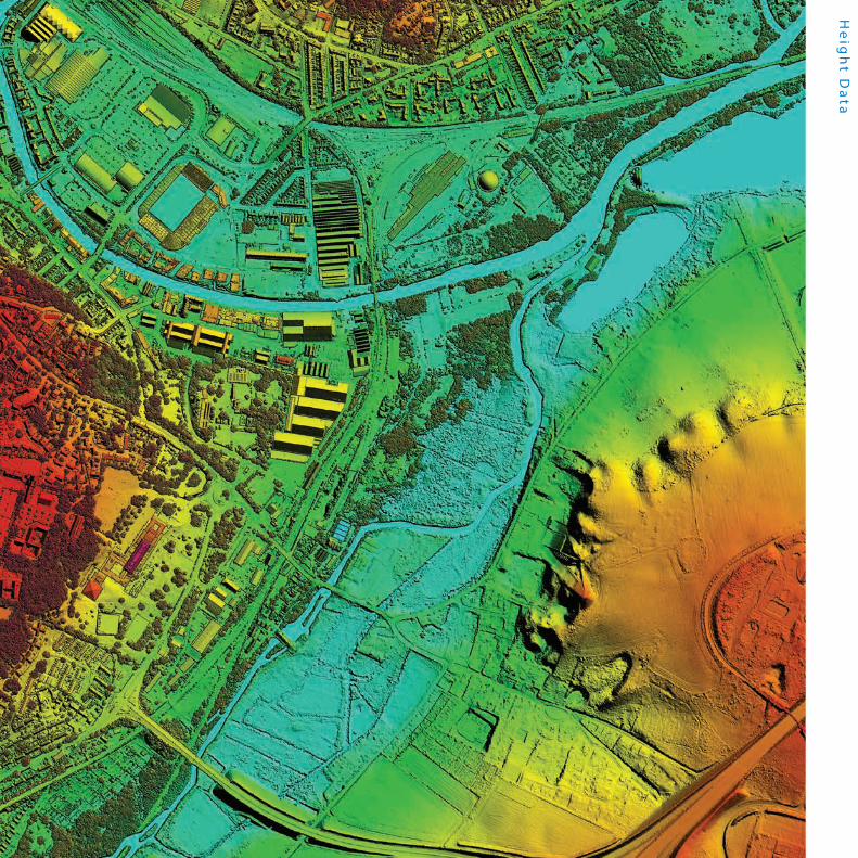
The surface of the earth is beautifully varied, from flat plains, to undulating countryside, to lofty mountains, all affected by rivers, vegetation and of course human impact. Understanding the lie of the land is absolutely fundamental in many applications; up-to-date height data from Bluesky easily brings this information to the user. Detailed measurements of the height of the ground and the structures or vegetation on it, provide new and invaluable information to help our understanding and management of the local, national or global environment. Bluesky’s range of height products, designed to take geographic information to the next level, include LiDAR and photogrammetrically derived surface and terrain models.
LiDAR DSM & DTM – high resolution and accurate terrain and surface measurements converted into models available off-the-shelf and by commission to customers’ exact specifications, created using an airborne laser system.
Photogrammetric DSM & DTM - national terrain and surface models available off-the-shelf and updated every 3 years. Created from high resolution stereo aerial photography.
Applications for Bluesky’s suite of height data include: civil engineering, insurance, flood risk analysis, quarrying & volumetrics, mobile network planning, roof and ground slope analysis, line of sight and visualisation assessments.
“ f r o m r i v e r d e e p t o m o u n t a i n h i g h ”
Height Data
He
igh
t Da
ta

A E R I A LL i D A RO B L I Q U ET H E R M A L
AIRCRAFTSENSORS
FLIGHT PLANSG P S
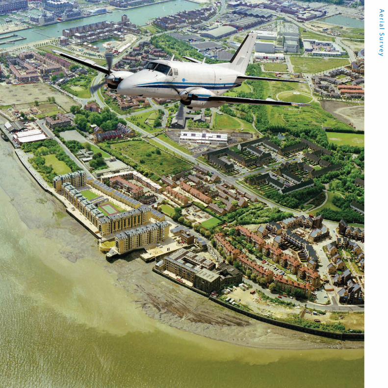
Bluesky is one of the leading suppliers of aerial survey services in the UK, Europe and the US offering the most up-to-date data and using the most advanced aerial survey equipment. Taking a fresh approach to aerial survey, we have built our processes and workflows from the ground up, based on new, innovative and cutting-edge methods.
We are able to offer you a full aerial survey service. All Bluesky survey equipment is fitted with an advanced Inertial Navigation System (INS) incorporating top of the range Applanix IMU
and GPS systems. Flight planning is conducted utilising a range of aerial survey industry standard software that ensure optimal flights are planned to achieve the very best deliverable. Bluesky operates large format Vexcel cameras, as well as an Optech LiDAR, Phase 1, Leica CityMapper and a thermal sensor.
Our team of flight operations experts, ground support and data processors, give users peace of mind that the aerial survey data is being captured by industry leading professionals and technology.
“ e y e i n t h e s k y ”
Aerial Survey
Ae
rial S
urv
ey

SUBSIDENCE
BIOMASS
AFFORESTATION
DEFORESTATION
ASSET MANAGEMENT
RISK ASSESSMENT
PROPAGATION STUDIES
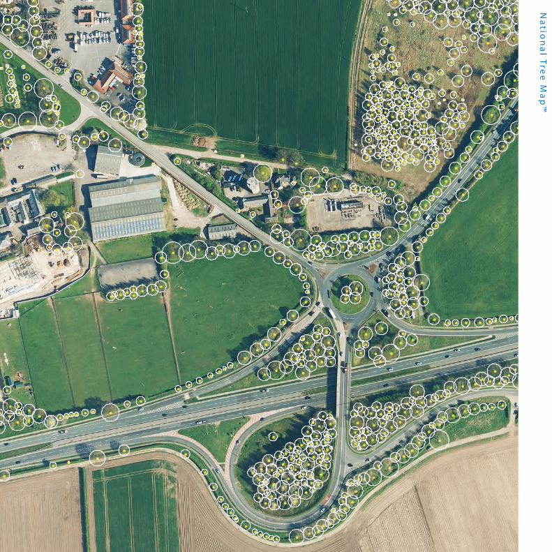
Trees form an important part of both our urban and natural landscape. Tree management has historically been a challenge, but Bluesky’s National Tree Map™, the first ever detailed national map of trees, has changed that. It contains the spatial location of trees, together with canopy coverage and tree heights. Perfect for assessing subsidence risk for insurance purposes in terms of the proximity of trees to buildings, as well as the management and maintenance of assets affected by tree branches or tree roots such as power lines, highways, railways, pipelines and telecommunication masts. National Tree Map™ is being updated every 3 years in line with Bluesky’s imagery and height programme.
National Tree Map™ is a fantastic geographic data resource for anyone whose remit is to manage trees or monitor tree canopies such as Local Authorities or arboriculturalists. National Tree Map™ is compatible with OS MasterMap® and is GIS/CAD ready. Features of the product include idealised circular shaped crowns, polygons representing tree crowns and tree top height points in metres.
The inherant height information in the data allows it to be viewed in 3D, meaning it can be used for visualisation, and is a must have for architects and planners, wanting to show a real-world view of a development.
“ f r o m t i n y a c o r n s ”
National Tree Map™
Na
tion
al T
ree
Ma
p™
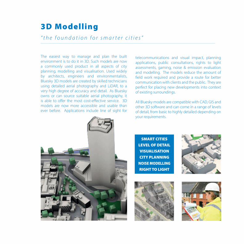
SMART CITIES LEVEL OF DETAILVISUALISATIONCITY PLANNING
NOISE MODELLINGRIGHT TO LIGHT
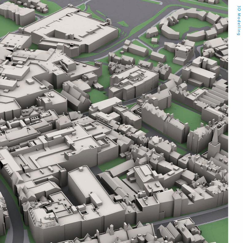
The easiest way to manage and plan the built environment is to do it in 3D. Such models are now a commonly used product in all aspects of city planning, modelling and visualisation. Used widely by architects, engineers and environmentalists, Bluesky 3D models are created by skilled technicians using detailed aerial photography and LiDAR, to a very high degree of accuracy and detail. As Bluesky owns or can source suitable aerial photography, it is able to offer the most cost-effective service. 3D models are now more accessible and usable than ever before. Applications include line of sight for
telecommunications and visual impact, planning applications, public consultations, rights to light assessments, gaming, noise & emission evaluation and modelling. The models reduce the amount of field work required and provide a route for better communication with clients and the public. They are perfect for placing new developments into context of existing surroundings.
All Bluesky models are compatible with CAD, GIS and other 3D software and can come in a range of levels of detail, from basic to highly detailed depending on your requirements.
“ t h e f o u n d a t i o n f o r s m a r t e r c i t i e s ”
3D Modelling
3D
Mo
de
lling

BEDS IN SHEDS
ILLEGAL DWELLINGS
FUEL POVERTY
BUILDING CONTROL
The thermal mapping service from Bluesky is an intelligent thermographic spatial information source for deriving property-level building heat-loss maps, used to identify poorly insulated buildings and potential “Beds in Sheds”. When captured in conjunction with simultaneous LiDAR data, the data can highlight previously unmapped buildings with a heat signature – and may indicate unlawful development which have been constructed for human habitation without planning permission or building regulations approval.
Bluesky provides an end-to-end thermal mapping solution, offering a cost-effective airborne thermal survey service that maps relative building heat-loss levels
across an entire city in just one evening. The results can be linked to addresses and energy consumption data to discover energy usage trends at neighbourhood levels, helping support energy strategies and respond to national indicators. The easy-to-use thermal maps enable the identification of properties which may need targeted assistance. Thermal mapping can also be used for pollution monitoring and in forestry studies to identify diseased or infested trees.
Our thermal surveys are conducted with state-of-the-art sensors, under optimal conditions to provide the most vivid and clear heat-loss results.
“ t h e h e a t i s o n ”
Thermal Imagery

Th
erm
al Im
ag
ery
LARGE SCALEC A D
DETAILG I S
39.9
39.6
39.5
39.8
40.4
40.4
40.4
39.3
39.7
40.4?
4040
40
40
40
40
40
40
39.3
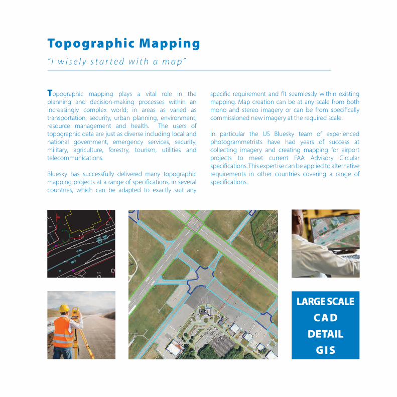
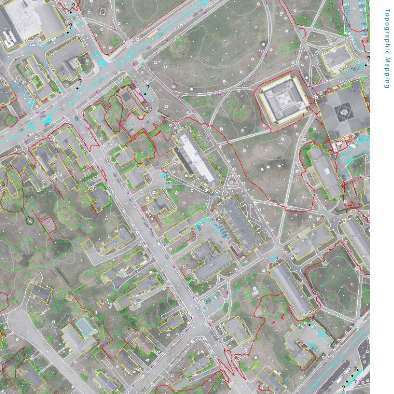
39.6
Topographic mapping plays a vital role in the planning and decision-making processes within an increasingly complex world; in areas as varied as transportation, security, urban planning, environment, resource management and health. The users of topographic data are just as diverse including local and national government, emergency services, security, military, agriculture, forestry, tourism, utilities and telecommunications. Bluesky has successfully delivered many topographic mapping projects at a range of specifications, in several countries, which can be adapted to exactly suit any
specific requirement and fit seamlessly within existing mapping. Map creation can be at any scale from both mono and stereo imagery or can be from specifically commissioned new imagery at the required scale. In particular the US Bluesky team of experienced photogrammetrists have had years of success at collecting imagery and creating mapping for airport projects to meet current FAA Advisory Circular specifications. This expertise can be applied to alternative requirements in other countries covering a range of specifications.
“ I w i s e l y s t a r t e d w i t h a m a p ”
Topographic Mapping
Top
og
rap
hic M
ap
pin
g
Bluesky UK
www.bluesky-world.com
+44 (0)1530 518518
Bluesky International Ltd.The StationStation RoadAshby-de-la-ZouchLE65 2ASUK
Bluesky US
www.bluesky-world.us
+1 800 359 8676
Bluesky Geospatial Ltd.808 State RoadHarriman & West AirportNorth Adams, MA01247 USA
Bluesky Ireland
www.bluesky-world.ie
+353 (0)21 2409026
Bluesky Geospatial Ltd.Building 1000City GateMahonCorkIreland