bhúmi, the planning research journal vol. 06, no.01, june
TRANSCRIPT
B.H. Sudantha, K.M.H.K. Warnakulasooriya, Y.P. Jayasuriya, G.R. Ratnayaka, P.K.S. Mahanama, E.J. Warusavitharana, S.N. Weerasinghe
23
Bhúmi, The Planning Research Journal
Vol. 06, No.01, June 2018
Open-source implementation of an integrated, low-cost environmental mon-
itoring system (EMS) for developing countries
B.H. Sudanthaa, K.M.H.K. Warnakulasooriyaa, Y.P. Jayasuriyaa,
G.R. Ratnayakab1, P.K.S. Mahanamab, E.J. Warusavitharanab and S.N. Weerasingheb
aFaculty of Information Technology, University of Moratuwa, Sri Lanka
bDepartment of Town & Country Planning, University of Moratuwa, Sri Lanka _______________________________________________________________________________________________________
Abstract
Whilst widely accepted as an important facet of Open Source technologies and their application, the scientific evaluation of such
technologies and systems is often underexplored in research. This work presents an integrated approach of developing a proto-
type Environmental Monitoring System (EMS) based on open source hardware & software, and the system’s reliability in terms
of data accuracy. The system is able to measure nine environmental parameters: rainfall, temperature, barometric pressure, hu-
midity, wind speed, wind direction, solar radiation, soil moisture and water level. Opposing to sophisticated and conventional
environmental data collection systems such as automatic and manual weather stations belong to Meteorological and Irrigation
department of Sri Lanka, this research has shown a promising way of establishing a dense coverage to monitor the environmen-
tal phenomena in a more cost effective manner.
Keywords: Automatic weather stations, Non conventional, Open -source environmental monitoring information,
Real time data, Sensors
1. Introduction
This research is based on an emerging domain called
Internet of Things (IoT), which has a great potential for
societal, environmental as well as economic impact
(Coetzee & Eksteen, 2011) that ultimately enables
smarter decisions. The term Internet of Things (IoT) is
simply the point in time when more “things or objects”
were connected to the internet than people (Evans,
2011). IoT has been around for the past few years
and is gaining recognition with the breakthrough of
advanced wireless technology (Huang & Li, 2010;
Ucklemann, Harrison, & Michahelles, 2011). The most
important thing in IoT is it provides the necessary
infrastructure to transparently access sensors, processes
and actuators using standardized protocols regardless of
hardware, operating systems or location (Presser, et al.,
2009; Roggen, et al., 2013).
The IoT based applications have been started to become
popular as a more cost effective product, after the
integration of open hardware and open software in
system development. The open source software packages
and open hardware sensors have become widely used on
a global scale in reducing costs of environmental
monitoring (Bitella, et.al, 2014; Formisano, Massera, &
De Vito, 2015; Sadler, et.al, 2014; Samourkasidis &
Athanasiadis, 2014; Prescott, et.al, 2016). In Sri Lankan
context, IoT intergraded innovative experiments have
been used in environmental assessment research areas
such as safety and fear of crime (De Silva,
Warusavitharana & Ratnayake, 2017; Ratnayake, 2013;
Ratnayake, 2016; Ratnayake, 2017; Ranasinghe et al.,
2016).
According to Artiola, Pepper, and Brusseau (2004) and
Wiersma (2004) “Environmental Monitoring” is defined
as the systematic sampling of air, water, soil, and biota
in order to observe and study the environment, as well as
to derive knowledge of this process. In this study, the
term “System” refers to a set-up which worked as a
station networked by a wireless protocol. For the
purpose of this study, the term “Environmental
Monitoring System” (EMS) refers to a station networked
by a wireless protocol which systematically observe and
collect data on environment, especially with regard to
air, water and soil. Hence, within the concept of IoT,
with reference to environmental data, a new opportunity
is given by the usage of non-conventional sources to
collect information of several parameters.
In this view, non-conventional systems and sensors (low
cost devices automatically providing measures) will be
more and more important in the future, either as a
complement to standard and authoritative monitoring
systems or as a vital data source in regions where
____________________________
1Corresponding Author:
ORCID: https://orcid.org/0000-0002-8733-9060 Email address: [email protected] DOI: http://doi.org/10.4038/bhumi.v6i1.36

Open-Source Implementation of an Integrated, Low-Cost Environmental Monitoring System (EMS) for Developing Countries
24
_______________________________________________________________________________________________________
traditional observation networks are in decline or
missing (Bell, Cornford, and Bastin, 2013). In fact, these
“crowdsourced” data (Muller et al., 2015) are very
attractive due to their nature of being generally available
in near-real time with high spatio-temporal resolution
and therefore potentially being able to fill the gap in
detecting the local activities in various geographic
locations that go unnoticed (Goodchild, 2007).
2. The Approach
Water A fast growth in mobile connectivity and smart
device diffusion in developing countries have been
observed (GSMA, 2014; Mierzwa et al., 2014) and this
could be a great opportunity for setting-up monitoring
systems at low-cost which could be used to address a
number of practical issues associated with weather
prediction, hazards and climatic changes.
In this background, a joint research project called
“4ONSE” was commenced between University of
Moratuwa, Sri Lanka and University of Applied
Sciences of Arts Southern Switzerland (SUPSI). 4ONSE
is the acronym for “4 times Open & Non-conventional
technologies for Sensing the Environment”. This study
was commenced in an era where the necessity of a low
cost, non-conventional and precise environmental
monitoring system is greatly demanding due to the rise
in the number of natural disasters and uncertain weather
predictions. As a solution for traditional and high cost
weather data collection and processing procedures, this
research argues a need for an open technologies based
approach to monitor the environmental phenomena in a
more cost effective manner.
This research assumes, some hypotheses. First,
commonly accepted assumption is that the IoT has a
great potential for societal, environmental as well as
economic impact (Coetzee et al., 2011; Evans, 2011)
enabling smarter decisions. Second is that the lack of
efficient, dense and modern monitoring systems in
developing countries is due to the lack of sustainable
solutions that meet local needs. This is supported by
evidence found in literature, that highlight how existing
networks have been mainly set up by foreign countries
to monitor global, rather than local, phenomena and that
identified as a key factor in system failures the
inaccessibility to funds and local support (Snow, 2013).
Third hypothesis is given by the assumption that in the
coming years the technological diffusion of mobile
internet would reach most of the world, including not
only the most populated areas but also the most remote
regions.
Evolution of this technology in developing countries
cannot exactly be predicted, but there are marketing and
economic studies that forecast a fast growing diffusion
of wireless connectivity and smart devices in the near
future (GSMA, 2014).
Given the importance and potential of IoT, and the
above formulated hypotheses, a possible solution to
globally existing issues and data gaps in developing
countries may be given by a fully Open and Non-
conventional System for sensing the Environment. A
‘Fully Open’ system is composed of Open Hardware,
Open Software, Open Standards, and Open Data whilst
‘Non-conventional’ intends a low-cost system which
does not respect all the high standard requirements in
terms of sensor construction, precision, and testing.
The main objective of this research is to setting-up an
experimental, fully open and non-conventional
environmental monitoring system which can withstand
weather conditions of the country. However, the
sustainability of the system as a low cost, non-
conventional and universally accepted product is depend
primarily on its system performance. Testing the
performance of the system is a long term task, which
involves collecting and analyzing data and information
on sensor outputs and system errors during the stages of
system development and deployment. In this research
paper, only the sensor outputs have been validated to
show the system’s performance in terms of data
accuracy.
2.1 System Architecture
The EMS system comprises of two stations – main
station and river gauge. The main station is capable of
measuring wind speed, wind direction, temperature,
rainfall, humidity, solar radiation, barometric pressure,
and soil moisture. The river gauge measures the water
level. The EMS system has been developed as an
Arduino Mega2560 based embedded system. All sensors
except river gauge are directly connected to the main
system. Station with river gauge has been separately
developed using Arduino UNO, and necessary electronic
modules.
Communication between the main system and river
gauge has been established using wireless technologies.
All types of processing and controlling are carried out
by Arduino Mega2560 and all data collected at the
station is sent to the main server using GSM technology.
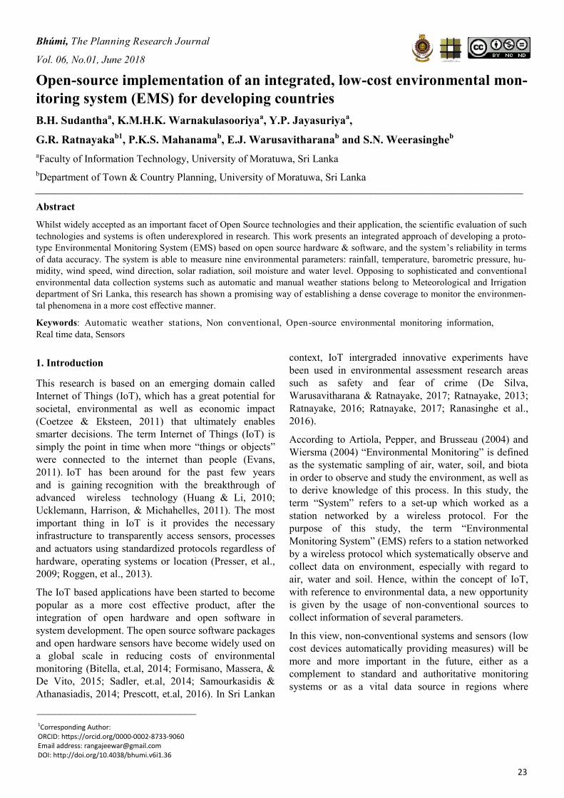
Figure 1 illustrates the block diagram of the main
system’s architecture.
The main controller of the system is Arduino Mega2560
and its functions are obtaining data from all sensors,
processing some of the data before sending them to the
server, controlling and communicating with other
peripherals, including SD module, real time clock
module (RTC), fan controller and GSM module. Figure
2 illustrates the schematic diagram of the main system.
B.H. Sudantha, K.M.H.K. Warnakulasooriya, Y.P. Jayasuriya, G.R. Ratnayaka, P.K.S. Mahanama, E.J. Warusavitharana, S.N. Weerasinghe
25
Figure 1: Block diagram of the main system architecture
2.2 The Printed Circuit Board (PCB) of the System
The main PCB (Printed Circuit Board) was designed,
including all circuit modifications of the main system.
Arduino Mega controller, GSM (Global System for
Mobile communication) module, RTC (Real Time
Clock), fan controller, and SD modules were separately
mounted within the main system box. All connections
between the PCB and above mentioned modules were
made by using jumper wires. This design stage
comprised of three boxes as shown in Figure 3, namely
main controller box (main processing unit), sensors
connectivity box (sensor unit) and power control box
(power supply unit). The main controller box contained
the final version of the PCB with wired connection of
Arduino Mega, GSM, RTC, SD module, soil
moisture signal conditioning module and fan controller.
All sensors, as shown in Table 1, are connected to the
sensor connectivity box and connection bus with power
lines are linked between the main box and sensor
connectivity box. Figure 4 illustrates the all-inclusive
view of the final version of the PCB which is used in the
current system, and Figure 5 illustrates the final version
of the system with all components connected.
Figure 2: Schematic diagram of the main system
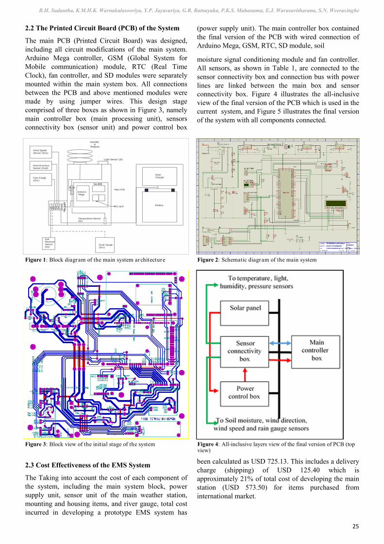
Figure 3: Block view of the initial stage of the system Figure 4: All-inclusive layers view of the final version of PCB (top view)
2.3 Cost Effectiveness of the EMS System
The Taking into account the cost of each component of
the system, including the main system block, power
supply unit, sensor unit of the main weather station,
mounting and housing items, and river gauge, total cost
incurred in developing a prototype EMS system has
been calculated as USD 725.13. This includes a delivery
charge (shipping) of USD 125.40 which is
approximately 21% of total cost of developing the main
station (USD 573.50) for items purchased from
international market.
Open-Source Implementation of an Integrated, Low-Cost Environmental Monitoring System (EMS) for Developing Countries
26
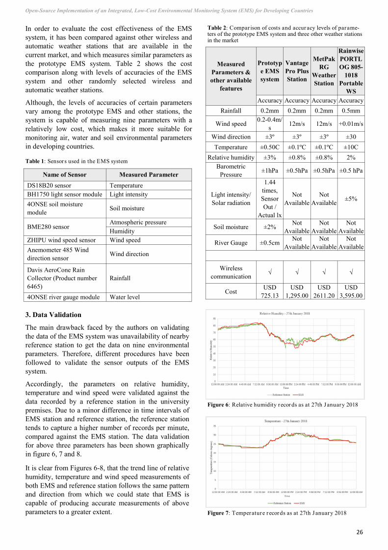
In order to evaluate the cost effectiveness of the EMS
system, it has been compared against other wireless and
automatic weather stations that are available in the
current market, and which measures similar parameters as
the prototype EMS system. Table 2 shows the cost
comparison along with levels of accuracies of the EMS
system and other randomly selected wireless and
automatic weather stations.
Although, the levels of accuracies of certain parameters
vary among the prototype EMS and other stations, the
system is capable of measuring nine parameters with a
relatively low cost, which makes it more suitable for
monitoring air, water and soil environmental parameters
in developing countries.
Name of Sensor Measured Parameter
DS18B20 sensor Temperature
BH1750 light sensor module Light intensity
4ONSE soil moisture
module Soil moisture
BME280 sensor Atmospheric pressure
Humidity
ZHIPU wind speed sensor Wind speed
Anemometer 485 Wind
direction sensor Wind direction
Davis AeroCone Rain
Collector (Product number
6465)
Rainfall
4ONSE river gauge module Water level
Table 1: Sensors used in the EMS system
Measured
Parameters &
other available
features
Prototyp
e EMS
system
Vantage
Pro Plus
Station
MetPak
RG
Weather
Station
Rainwise
PORTL
OG 805-
1018
Portable
WS
Accuracy Accuracy Accuracy Accuracy
Rainfall 0.2mm 0.2mm 0.2mm 0.5mm
Wind speed 0.2-0.4m/
s 12m/s 12m/s +0.01m/s
Wind direction ±3º ±3º ±3º ±30
Temperature ±0.50C ±0.1ºC ±0.1ºC ±10C
Relative humidity ±3% ±0.8% ±0.8% 2%
Barometric
Pressure ±1hPa ±0.5hPa ±0.5hPa ±0.5 hPa
Light intensity/
Solar radiation
1.44
times,
Sensor
Out /
Actual lx
Not
Available
Not
Available ±5%
Soil moisture ±2% Not
Available
Not
Available
Not
Available
River Gauge ±0.5cm Not
Available
Not
Available
Not
Available
Wireless
communication √ √ √ √
Cost USD
725.13
USD
1,295.00
USD
2611.20
USD
3,595.00
Table 2: Compar ison of costs and accuracy levels of parame-ters of the prototype EMS system and three other weather stations in the market
3. Data Validation
The main drawback faced by the authors on validating
the data of the EMS system was unavailability of nearby
reference station to get the data on nine environmental
parameters. Therefore, different procedures have been
followed to validate the sensor outputs of the EMS
system.
Accordingly, the parameters on relative humidity,
temperature and wind speed were validated against the
data recorded by a reference station in the university
premises. Due to a minor difference in time intervals of
EMS station and reference station, the reference station
tends to capture a higher number of records per minute,
compared against the EMS station. The data validation
for above three parameters has been shown graphically
in figure 6, 7 and 8.
It is clear from Figures 6-8, that the trend line of relative
humidity, temperature and wind speed measurements of
both EMS and reference station follows the same pattern
and direction from which we could state that EMS is
capable of producing accurate measurements of above
parameters to a greater extent.
Figure 6: Relative humidity records as at 27th January 2018
Figure 7: Temperature r ecords as at 27th January 2018
B.H. Sudantha, K.M.H.K. Warnakulasooriya, Y.P. Jayasuriya, G.R. Ratnayaka, P.K.S. Mahanama, E.J. Warusavitharana, S.N. Weerasinghe
27
During the designing stage of the weather station, a
commercially available low cost soil moisture sensor was
used. Since it was caused for corrosion with the time
while giving erroneous readings, the authors have
developed a new soil moisture module using stainless
steel tubes. Figure 9 shows the calibration curve related
to newly developed soil moisture module tested at the
laboratory.
The atmospheric pressure records were validated against
the records of an official station belongs to
Meteorological department. This station is located at a
coastal belt, 4.5km away from the prototype EMS station.
Since the atmospheric pressure is usually higher at sea
level, the reference station’s records are slightly higher
than the EMS records (Figure 10).
The data validation with reference to rainfall, wind
direction, solar radiation and water level have not been
shown in this study due to the unavailability of reliable
reference data. However, this work will aim to validate
the accuracy of all the sensor outputs by installing the
EMS station and a reference station at a same location.
4. Conclusion
The delivered prototype demonstrates that open source
based EMS system offers a platform for developing a
cost effective, portable, easily installed and autonomous
system which measures environmental parameters at a
low cost. In doing so, it combines open hardware and
open software technologies. The system is able to operate
as a remote measurement system equipped with
renewable energy source, wireless data communication,
data logging and displaying facilities. At this stage the
accuracy levels of the measurements have been validated
following numerous procedures, under the constraints of
unavailability of a nearby reference station which
provides data on required nine environmental parameters.
A number of works are being carried to analyze the
system’s durability and consistency in deploying them in
the field. In addition, experiments are being carried to test
the suitability of components in the main processing unit,
power supply units and sensors against the fluctuating
weather conditions and weather proofing the electrical
and electronic units. While addressing all the pros and
cons of the system, the authors wish to present the overall
sustainability of the EMS system in terms of cost,
durability, maintenance and quality of data in the near
future.
5. Acknowledgement
Authors would like to thank Swiss Agency for
Development and Cooperation (SDC) and Swiss National
Science Foundation (SNSF) for providing necessary
funds to carry out this research.
Figure 8: Wind speed records as at 27th January 2018
Figure 9: Calibration curve of the stainless steel soil moisture module
Figure 10: Atmospher ic pressure records dur ing the per iod of 16th January – 18th February 2018

Open-Source Implementation of an Integrated, Low-Cost Environmental Monitoring System (EMS) for Developing Countries
28
6. References
Artiola, J.F., Pepper, I.L., Brusseau, M. (Eds.). (2004). Environmental Monitoring and Characterization. Burlington,
MA: Elsevier Academic Press.
Bell, S., Cornford, D. and Bastin, L. (2013). The state of automated amateur weather observations. Weather, 68(2),
pp.36-41.
Bitella, G., Rossi, R., Bochiccchio, R., Perniola, M., & Amato, M. (2014). A novel low cost open hardware platform
for monitoring soil water content and multiple soil-air-vegetation parameters. Sensors, 14, 19639 -19659.
Coetzee, L. and Eksteen, J. (2011). The Internet of Things-promise for the future? An introduction. In: IST-Africa
Conference Proceedings. pp.1-9.
Evans, D. (2011). The Internet of Things: How the next evolution of the intenet is changing everything. Cisco
Internet Business Solutions Group. Retrieved December 2016, from http://www.cisco.com/c/dam/en_us/about/ac79/
docs/innov/IoT_IBSG_0411FINAL.pdf
Formisano, F., Massera, E., & De Vito, S. (2015). Tinynose, an Auxiliary smart gas sensor for RFID tag in
vegetables ripening monitoring during refrigerated cargo transport. Retrieved May 2017, from https://
www.researchgate.net/publication/278668294
Goodchild, M. (2007). Citizens as sensors: the world of volunteered geography. GeoJournal, 69(4), pp.211-221.
GSMA, 2014. The Mobile Economy 2014 GSMA 2014. Available online at: http://www.gsmamobileeconomy.com/
GSMA_ME_Report_2014_R2_WEB.pdf [consulted on January 2015]
Huang, Y., & Li, G. (2010). Huang, Y., & Li, G. (2010). A Semantic Analysis for Internet of Things. IEEE - 2010
International Conference on Intelligent Computation Technology and Automation.
Mierzwa, S., Souidi, S., Austrian, K., Hewett, P., Isaac, A., Maimbolwa, M., & Wu, C., 2014. Transitioning
Customized ACASI Windows. NET Solution to Android Java on Lower-Priced Devices and Technical Lessons
Learned. The Electronic Journal of Information Systems in Developing Countries, 66
Muller, C., Chapman, L., Johnston, S., Kidd, C., Illingworth, S., Foody, G., Overeem, A. and Leigh, R. (2015).
Crowdsourcing for climate and atmospheric sciences: current status and future potential. International Journal of
Climatology, 35(11), pp.3185-3203.
Prescott, E., Rome, C., Marchiori, A., & Hayes, B. (2016). HydroSense: An open platform for hydroclimatic
monitoring. Retrieved May 2017, from http://www.eg.bucknell.edu/wse/documents/journal_articles/
smartcomp2016.pdf
Presser, M., Eurich, M., Villalonga, C., & Barnaghi, P. (2009). The SENSEI project: Integrating the physical with
the digital world of the network of the future. IEEE Commun. Mag., 47, 1-4.
Ratnayake, R. (2017). Sense of safety in public spaces: University student safety experiences in an Australian
regional city. Rural Society, 26(1), 69-84.
De Silva, C. S., Warusavitharana, E. J., & Ratnayake, R. (2017). An examination of the temporal effects of
environmental cues on pedestrians' feelings of safety. Computers, Environment and Urban Systems, 64, 266-274.
Ratnayake, R. (2013). Environmental features and sense of safety. WIT Transactions on Ecology and the
Environment, 179, 377-388.
Ratnayake, R. (2016). Fear of crime in urban settings: Influence of environmental features, presence of people and
social variables. Bhumi, The Planning Research Journal, 3(2).
Ranasinghe, G., Amarawickrama, S., & Rathnayake, R. (2016). A Study to Compare the Level of Walkability in
Two Urban Neighborhoods of Sri Lanka. International Journal of Engineering Research and General Science, 4(1), 6
-13.
Roggen, D., Troster, G., Lukowicz, P., Ferscha, A., Millan, J., & Chavarriaga, R. (2013). Opportunistic human
activity and context recognition. Computer, 46, 36-45.
Sadler, J., Ames, D., & Khattar, R. (2014). Open hardware meets open software for environmental monitoring. 7th
International congress of environmental modelling and software. Retrieved December 2016, from https://
www.researchgate.net/publication/264417370

B.H. Sudantha, K.M.H.K. Warnakulasooriya, Y.P. Jayasuriya, G.R. Ratnayaka, P.K.S. Mahanama, E.J. Warusavitharana, S.N. Weerasinghe
29
Samourkasidis, A., & Athanasiadis, I. (2014). Towards a low cost, full service air quality data archival system. 7th
International congress on environmental modelling and software. Retrieved December 2016, from http://
www.iemss.org/sites/iemss2014/papers/iemss2014_submission_300.pdf
Snow, J.T., 2013. Non-traditional Approaches to Weather Observations in Developing Countries. International
Finance Corporation. Available online at: http://www.ifc.org/wps/wcm/connect/
91c3778042bd94eeb2c6be0dc33b630b/
NonTraditional+Approaches+to+Weather+Observations+in+Developing+Countries+-+John+Snow.pdf?
MOD=AJPERES [consulted on January 2015]
Ucklemann, D., Harrison, M., & Michahelles, F. (2011). Architecting the Internet of Things. New York: Springer
Heidelberg Dordrecht.
Wiersma, G.B. (Ed.) (2004). Environmental Monitoring. Boca Raton, FLA: CRC Press.