base appraisal report donkey terraces remote recreational...
TRANSCRIPT
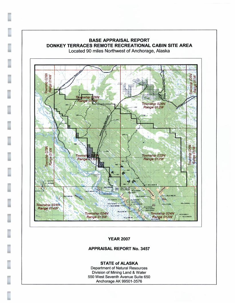
BASE APPRAISAL REPORT DONKEY TERRACES REMOTE RECREATIONAL CABIN SITE AREA
Located 90 miles Northwest of Anchorage, Alaska
YEAR 2007
APPRAISAL REPORT No. 3457
STATE of ALASKA Department of Natural Resources Division of Mining Land & Water
550 West Seventh Avenue Suite 650 Anchorage AK 99501-3576
DONKEYTERRACESREMOTESTAKINGAREA APPRAISALBASE REPORTNo. 3457
TABLE OF CONTENTS
INTRODUCTION
Title Page Letter of Transmittal Table of Contents Appraisal Summary, Key Lot Values, and Adjustments
1 2 3
PREMISE OF THE APPRAISAL
Type of Appraisal and Report Purpose and Use of the Appraisal Definition of Market Value Client and User Identity Property Rights Appraised Definition of Market Value Extraordinary Assumption Effective Date of Value Estimate Exposure/Marketing Time Scope of the Appraisal Assumptions and Limiting Conditions
PRESENTATION OF DATA
66666677779
Skwentna Area Analysis 10 Petersville Area Analysis 11 Staking Area Summary 15
DATA ANALYSIS AND CONCLUSION
Highest and Best Use 17 Sales Comparison Approach 18 Key Parcel Method 18 Description and Valuation of Key Parcel "A" 18 Explanation of Adjustments 19 Comparable Sales 20 Reconciliation Parcel "A" 22 Description and Valuation of Key Parcel "B" 23 Reconciliation Parcel "8" 23 Certification of Value 26
ADDENDA Comparable Sales Maps & Forms Size Adjustment Generally Allowed Uses Final Finding
I:\MRW RRCSFiles\donkey terrace2007\DonkeyTerraceRRCSmaster.doc 01/08/07
2
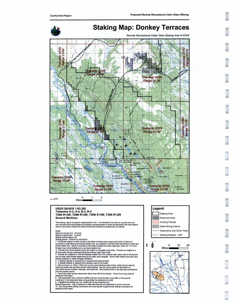
Proposed Remote Recreat ional Cabin Sites OfferingSouthcentral Region
Staking Map: Donkey Terraces Remo te Recreational Cabin Sites Staking Area # ><XXX
o 2 Miles __-===
USGS QUADS 1:63,360 Talkeetna A-3 . A-4 . B-3, B-4 T26N R13W, T26N R12W. T25N R13W. T25N R12W Seward Meridian
This staking map is for graphic represeriation only . It is intendedto be used as a guide only am mayrot stow the exact locationof existirg surveyed parcels orshow' al l easementsam reservations. Source documerts remain the official record and stould be reviewed prior to staking .
Notes : MaxilTun pan:e4size: 20 acres Mi1iTJJm parcel size: 10 acres Staking authorizations: 60 Staking period : XXXXXX 10J()()()()()()(
1. Anpercesstakedon landowned by the Stateof Alaska thai oonlaln land wittOn50 feet of a suveyed or protracted (U'lSlJ'Veyed) sectionline. are subjectto a so-root wideeasement on ead'lside of the section line. whidl is reservedto the Stateof Alaska for publichighways under AS 19.10.010. Parcels maynotbe stakedovera sll'Veyedsection line. 2. Parcels mayro t be staked acrossany public or navigable water body. Parcels are subject to a 5().footpublic accesseasemenc along the ordinaryhigh watermark. 3. Parcels are subject to a tco-eot buDding setbackfromthe ordinaryhigh water mark of al streams and al other wate r bodies determi1ed to be putXicare navigatje. Some waler bodies may alsohave Slaking selbacksor waterfrontage Imitations. 4. A stakirg setback is reqused from lJ'lCkthorized improvements. 5. A stakirYJ setbackis requred fromairstrips used by the pl.t>l<:. 6. Mostsu""ys (i.e. ASLS. USS) ha"" SUM!}' rrorumerts at ead> corner , whim can be used as referencepoots aoooormrJn mmers when stafQng. see the suvey jjats for informatbnon rn::nJrmrt oomerm.mbers. bearings , ard distances. Morumerts fotn:i inthe tietdtake prec:eder'Io! over the grapnc record. 7. There are public access easementsaloro most ASLS booo:taries. Check the 5LWVeY plats for add itiona l information. 8. Trail easements have not been veri fied 300 thei r actuallocal:ion may differ on the grolKld . L.abeling of a trail easemert does notguarantee the existenceof a trail. 9. Unautho rized airst rips are rot mainta ined by the Departmert of Natural Resources. Use of airstrips on state lard that are rot auttorized is at yourownrisk. 10. See the general staki "'J instructions am ~specifc st.JPP'emertaistakirg instruaions for additional information.
Legend
o Staking Area
_ Reserved Area
o Existing Parcels
~ Stale Mining Claims
----- Easements and Other Trails
_ ._ . _ . Staking Setback - 200 '
o 10 20 Miles ± o __-===::J
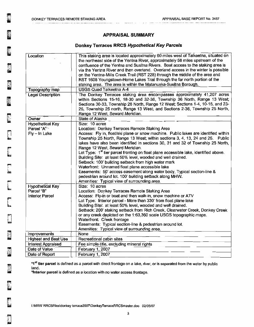
DONKEY TERRACES REMOTE STAKING AREA APPRAISAL BASE REPORT No. 3457
APPRAISAL SUMMARY
Donkey Terraces RRCS Hypothetical Key Parcels
o
Location This staking area is located approximately 60 miles west of Talkeetna, situated on the northeast side of the Yentna River, approximately 58 miles upstream of the confluence of the Yentna and Susitna Rivers. Boat access to the staking area is via the Yentna River and then overland. Overland access in the winter is possible on the Yentna-Mills Creek Trail (RST 228) through the middle of the area and RST 1608 Youngstown-Home Lakes Trail through the far north portion of the staking area. The area is within the Matanuska-Susitna Borough. USGS Quad Talkeetna A-4 The Donkey Terraces staking area encompasses approximately 41,207 acres within Sections 15-16, 18-30 and 32-36, Township 36 North, Range 13 West; Sections 30-33, Township 26 North, Range 12 West; Sections 1-4,10-15, and 2325, Township 25 north, Range 13 West; and Sections 2-36, Township 25 North, Range 12 West, Seward Meridian. State of Alaska Size: 10 acres
Topography map Legal Description
Owner Hypothetical Key Parcel "A'!' Location: Donkey Terraces Remote Staking Area Fly-In Lake Access: Fly in, float/ski plane or snow machine. Public lakes are identified within
Township 25 North, Range 13 West; within sections 3, 4, 13, 24 and 25. Public lakes have also been identified in sections 30, 31 and 32 of Township 25 North, Range 12 West, Seward Meridian. Lot Type: 1st tier parcel fronting on float plane accessible lake, identified above. Building Site: at least 50% level, wooded and well drained. Setback: 100' building setback from high water mark Waterfront: Unnamed float plane accessible lake 'Easements: 5p' access easementalong water body, Typical section-line & pedestrian around lot. 100' building setback along MHW. Amenities: 'Typical view of surrounding area. Size: 10 acres Hypothetical Key
Parcel"B" Location: Dorikey Terraces Remote Staking Area Interior Parcel ,Access: Fly-i~ or boat and then walk-in, snow machine or ATV
Lot Type: lhterlor parcel - More than 330' from float plane lake Building Sit~: at least 50% level, wooded and well drained. Setback: 2QO' staking setback from Rich Creek, Clearwater Creek, Donkey Creek
,or any creek depicted on the 1:63,360 scale USGS topographic maps. Waterfront: Creek frontage Easements: Typical section-line &pedestrian around lot. Amenities: Typical view of surrounding area. None
: Recreational cabin sites Fee simple title, excluding mineral rights February 1, 2007 February 1, 2007
lrnprovernents Highest and Best Use Interest Appraised Date. of Value Date of Report
*15t tier parcel is defined as a parcel with direct frontage on a lake, river, or is separated from the water by public land. *Interior parcel is defined as a location with no water access frontage.
I:\MRW RRCSFiles\donkey terrace2007\DonkeyTerraceRRCSmaster.doc 02105/07
3

DONKEY TERRACES REMOTE STAKING AREA APPRAISAL BASE REPORT No. 3457
C90~lu~iboofValues fo.. Hyp~t.h(!ti~~I"·KeYP~I',~~I~~A" " . ,",
WATERFRONT Size $$ per Acre $$ per Site (rd.) Key Parcel -Minimum 10.00 $1,600 $16,000
15.00 $1,400* $21,000 Maximum Parcel Size 20.00 $1,200* $24,000
..'.
• * Based on size adjustment chart located In the Addenda. Key Parcel 10 Bold.
<. ConcliJ$i<inof Values for HYPotheti~~1 Key Parcel liB" , INTERIOR Size $$ per Acre
"
$$ per Site (rd.) $6,400 $8,400 $9,600
Key Parcel -Minimum 10.00 $640
Maximum Parcel Size i"
15.00 $560* 20.00 $480*
• * Based on size adjustment chart located In the Addenda. Key Parcel 10 Bold.
1.10to 1.20
Rich Creek, Clearwater Creek, Donkey Creek or any creek depicted 1.10 " n the 1:63,360 isc~le USGS topographic maps, pond, small lake }< fronta e or outstandin views.
D
Adjustment Process: An adlustrnent of.less than 1.00 means the feature of the staked parcel is inferior to the hypothetical key parcel and requires a downward price adjustment. An adlustrnent of greater than 1))0 means the feature is superior to' the hypothetical key parcel, requiring an upward adjustment. An ~djustment of 1.00 means the property feature is similar to the key parcel, and no adjustment is necessary. The adjustments are mul~iplied to obtain a total adjustment, which is then multiplied by the estimated value of the key parcel to yield a value for the staked parcel.
Fly-in Lakes/Public Navigable greater than 10 acres in size. Generally, lakes smaller than 10 acres are not determined navigable or public unless specifically identified. The following lakes are determined to be public waterbodies.
Within Township 25 North, Range 13 West, Seward Meridian. The unnamed lake in the SW 1/4 of section 3 The unnamed lake in the N Y:z of section 4 The unnamed lake in the SW 1/4 of section 13 The unnamed lake in the NW 1/4 of section 25
I:\MRW RRCSFiles\donkey terrace2007\DonkeyTerraceRRCSmaster.doc 02/05/07
4
I
DONKEY TERRACES REMOTE STAKING AREA APPRAISAL BASE REPORT No. 3457
o Within Township 25 North, Range 12 West, Seward Meridian. The unnamed lake in sections 30 and 31 The unnamed lake in the NW X of section 30 The unnamed lake in the S 1/2 of section 32
TYPE OF APPRAISAL AND REPORT This is a complete, summary appraisal prepared in accordance with Standard Rules 1 and 2 of the Uniform Standards of Professional Appraisal Practice, Appraisal Foundation, and in accordance with Special Appraisal Instructions, DNR Remote Cabin Sites.
PURPOSE OF THE APPRAISAL The purpose of this appraisal is to estimate the current market value of the properties described in this report.
INTENDED USE OF THE APPRAISAL This appraisal will be used to determine the purchase price for parcels to be acquired under the Remote Recreational Cabin Site program (AS 38.05.600).
CLIENT AND USER IDENTITY This appraisal is prepared for the State of Alaska, Department of Natural Resources and the general o public.
PROPERTY RIGHTS APPRAISED
The rights appraised are the fee simple estate less the mineral rights reserved to the State of Alaska under AS 38.05.125(a). Fee simple estate is defined' as:
"Absolute ownership unencumbered by any other interest or estate, subject only to the limitations imposed by the governmental powers of taxation, eminent domain, police power, and escheat."
AS 38.05.125(a) states":
Reservation. (a) Each contract for the sale, lease or grant of state land ... is subject to the following reservations: "[sic] the party of the first part, Alaska, hereby expressly saves, excepts and reserves ...unto itself, its lessees, successors, and assigns forever, all oils, gases, coal, ores, minerals, fissionable materials, geothermal resources, and fossils of every name, kind or description, and which may be in or upon said land...[and the right] to occupy as much of said land as may be necessary or convenient... to render beneficial and efficient the complete enjoyment of the property and rights hereby expressly reserved.
DEFINITION OF MARKET VALUE3
The most probable price, as of a specified date, in cash, or in terms equivalent to cash, or in other precisely reve.aled terms, for which the specified property rights should sell after reasonable exposure in a competitive market under all conditions requisite to a fair sale, with the buyer and seller each acting prudently, knowledgeably, and for self-interest, and assuming that neither is under undue duress.
In accordance with instructions from the State of Alaska, market value for the appraised property is estimated in terms of seller financing typical for the property type as of the date of appraisal.
1 The Appraisal of Real Estate, 12th Edition, Appraisal Institute, 2001, p.69 2 Alaska Statutes Title 38, Public Land Article 5, State of Alaska, 2002, pp. 590-591 3 The Appraisal of Real Estate, 12th Edition, Appraisal Institute, 2001, p.22
I:\MRW RRCSFiles\donkey terrace2007\DonkeyTerraceRRCSmaster.doc 01/08/07
5

DONKEY TERRACES REMOTE STAKING AREA APPRAISAL BASE REPORT No. 3457
DEFINITION OF EXTRAORDINARY ASSUMPTION4
"an assumption, directly related to a specific assignment, which, if found to be false, could alter the appraiser's opinions or conclusions.
The report is based on the extraordinary assumption that all staked parcels have legal access across any staking area setbacks identified within the staking area. It is assumed that these setbacks will remain in state ownership. It is assumed that the appropriate platting authority will approve plats for all parcels staked under this program. We reserve the right to amend this report should unanticipated platting problems require changes that would significantly impact value.
EFFECTIVE DATE OF VALUE ESTIMATE The effective date of the value estimate is February 1 ! 2007.
'·:·'·····
EXPOSURE TIME Exposure time is "... the estimated length of time the property interest being appraised would have been offered on the market prior to the hypothetical consummation of a sale at market value on the effective date of the appraisal ... ,,5
r,0 Exposure time varies with the type of property and changes with market conditions. The market for remote recreational properties has been sluggish for years. Supply has grown faster than demand. The market is somewhat saturated. Primary sellers are DNR, the University of Alaska, the Mental Health Lands Trust, Native allottees, and some boroughs. Remote parcels such as the subject typically require 12 or more months of marketing time.
Compared with competing parcels in the overall market for remote parcels, the market appeal for the subject parcels is average to poor. Considering exposure times for similar properties, appraised values for the subject parcels are based on an exposure time of one to three years.
,MARKETING TIME "Marketing time is an opinion of the amount of time it might take to sell a real or personal property interest at the concluded market value level during the period immediately after the effective date of an .appraisal."
I Cansidering current market conditions and forseeable supply and demand as of the date of appraisal, appraised values for the subject parcels are based on an estimated marketing time of one to three years.
SCOPE OF "rHE APPRAISAL I did not inspect the staking area in the field. Physical features, access and trails were identified by the use of topographic maps, status plats, aerial photographs. DNR appraisal records and interviews with people who are familiar with the area.
Also, DNR appraisal records were searched for recent sales of similar parcels. Interviews were conducted with real estate agents, appraisers, and other individuals who provided data about trends in values, supply and demand. Sellers and buyers were contacted to verify sale prices and other transaction details.
After analysis of all available data, appropriate sales were selected for comparison with a key parcel of the subject properties being appraised. The market value estimate is based on the following assumptions and conditions.
4 The Uniform Standards of Professional Appraisal Practice (USPAP), Appraisal Foundation, 2004, p.3 5 op, cit. p. 83. a Uniform Standards ofProfessional Appraisal Practice 2001, Appraisal Foundation, p. 128.
I:\MRW RRCSFiles\donkey terrace2007\DonkeyTerraceRRCSmaster.doc 01/08/07
6
DONKEY TERRACES REMOTE STAKING AREA APPRAISAL BASE REPORT No. 3457
ASSUMPTIONS AND LIMITING CONDITIONS
1. The property is appraised as vacant land without structural or site improvements.
2. The appraiser assumes no responsibility for legal matters. The subject lots are assumed to be free and clear of encumbrances, except as otherwise noted, and title is assumed to be marketable.
3. Some parcels may contain saw timber but not necessarily in commercial quantities. The estimated market value does not include the value of commercial timber, if any.
4. The data and conclusions embodied in this report are a part of the whole valuation. Each part of this appraisal is only part of the evidence upon which final judqernent is based. Therefore, no part should be used out of context and by itself alone.
5. The appraiser, by reason of this appraisal, is not required to give further consultation, testimony, or be in attendance in court with reference to the property in question, unless prior arrangement has been made and adequate time is provided to review the appraisal.
6. The estimate of value in this report is not based in whole or in part upon the race, color, or national origin of the present owners or occupants of the properties in the vicinity of the property appraised.
7. In this valuation various mathematical calculations were used to formulate the opinion of value. These calculations are only aids for the formulation of the opinion of value by the appraiser. Therefore, in the application of these calculations, certain arithmetical figures are rounded to the nearest significant amount.
8. The information furnished by others is believed to be reliable but it is not warranted for its accuracy. Plats of lease areas in this report are included for illustration only and may not be to scale.
9. It is assumed that there are no hidden or apparent conditions of the property, subsoil, or structures that render it more or less valuable. No responsibility is assumed for such conditions, or for arranging engineering studies to discover them.
10. Unless otherwise stated in this report, the appraiser does not know about the existence of hazardous materials or toxic substances, which mayor may not be present on the property. The appraiser is not qualified to detect such substances. No responsibility is assumed for any such conditions or for any expertise or engineering knowledge required discovering them.
11. The report is based on the extraordinary assumption that all staked parcels have legal access across any staking area setbacks identified within the staking area. It is assumed that these setbacks will remain in state ownership. It is assumed that the appropriate platting authority will approve plats for all parcels staked under this program. We reserve the right to amend this report should unanticipated platting problems require changes that would significantly impact value.
o D I:\MRW RRCSFiles\donkey terrace2007\DonkeyTerraceRRCSmaster.doc 01/08/07
7
DONKEY TERRACES REMOTE STAKING AREA APPRAISAL BASE REPORT No. 3457
PRESENTATION OF DATA
Skwentna Area Analysis Current Population: 75 (DCCED 2005 Cert. Pop.) Incorporation Type: Unincorporated Borough located In: Matanuska-Susitna Borough Taxes: Sales: None, Property: 11.483 mills (Borough), Special: 5% Accommodations Tax (Borough)
Location and Climate Skwentna lies on the south bank of the Skwentna River at its junction with Eight Mile Creek, 70 air miles northwest of Anchorage in the Mat-Su Borough. It lies in the Yentna River valley. The community lies at approximately 61.958610° North Latitude and -151.181110° (West) Longitude. (Sec. 29, T022N, R010W, Seward Meridian.) Skwentna is located in the Anchorage Recording District. The area encompasses 442.8 sq. miles of land and 6.9 sq. miles of water. January temperatures range from -30 to 33; July can vary from 42 to 83. Annual precipitation averages 28 inches, including 70 inches of snowfall.
History, Culture and Demographics Dena'ina Athabascans have fished and hunted along the Skwentna and Yentna Rivers for centuries. In 1908, an Alaska Road Commission crew blazed a trail from Seward to Nome, going through Old Skwentna from the Susitna River to Rainy Pass. Many roadhouses were later constructed along the trail to the Innoko Mining District, including the Old Skwentna Roadhouse. Prospectors, trappers and Indians often used sled dog~ to transport goods over the trail. Max and Belle Shellabarger homesteaded and started a guide service in 1923, and later a flying service and weather station. A post office was opened in 1937. After World War II, Morrison-Knudson built an airstrip, and in 1950, the U.S. Army established a radar station at Skwentna and a recreation camp at Shell Lake, 15 air miles from Skwentna. In the 1960s, State land disposals iincreased settlement.
The population of the community consists of 7.2% Alaska Native or part Native. Skwentna residents are , scattered over a large area of land. It has a number of seasonal-use homes. There is a small local store, I and area residents use snow machines or aircraft to travel to the post office. During the 2000 U.S.
Census, total housing units numbered 360, and vacant housing units numbered 310. Vacant housing units used only seasonally numbered 307. U.S. Census data for Year 2000 showed 59 residents as employed. The unemployment rate at that time was 0 percent, although 26.25 percent of all adults were not in the work force. The median household income was $16,250, per capita income was $23,995, and 5.77 percent of residents were Jiving below the poverty level
Facilities, Utilities, Schools and Health Care A number of homes have individual water wells, but septic tanks are rare, consequently, very few homes are fully plumbed. Outhouses are the primary means of sewage disposal. There is no central electric system. Funds have been provided to purchase a community refuse incinerator, however, the community is undecided on a refuse solution. An unpermitted dump site near the airport is currently being used by several families, but most residents burn and bury their own refuse. Electricity is provided by Individual Generators. There are no state operated schools located in the community. Local hospitals or health clinics include Valley Hospital (352-2860) in Palmer. Skwentna is classified as an isolated Village, it is found in EMS Region 2C in the Mat-Su Region. Emergency Services have highway and river access. Emergency service is provided by 911 Telephone Service and volunteers Auxiliary health care is provided by Lake Creek/Skwentna First Responders (373-88001745-4811).
Economy and Transportation Employment is provided through local lodges, the post office and the airstrip. There is no road access from the George Parks Highway -- residents are dependent upon air travel and snow machines. A Stateowned 3,400' long by 75' wide gravel airstrip is available. A private airstrip and float plane access are located at Alexander Lake
I:\MRW RRCSFiles\donkey terrace2007\DonkeyTerraceRRCSmaster.doc 01/08107
8
DONKEY TERRACES REMOTE STAKING AREA APPRAISAL BASE REPORT No. 3457
Petersville Area Analysis Current Population: 16 (DCCED 2005 Cert. Pop.) Incorporation Type: Unincorporated Borough Located In: Matanuska-Susitna Borough Taxes: Sales: None, Property: 11.483 mills (Borough), Special: 5% Accommodations Tax (Borough)
Location and Climate Petersville is located on Petersville Road, at mile 114.9 of the George Parks Highway, west of Trapper Creek. Petersville Road is 17 miles north of the junction to Talkeetna Spur Road. Peters Creek and the Deshka River flow through the community. The community lies at approximately 62.496390° North Latitude and -150.765560° (West) Longitude. (Sec. 21, T028N, R008W, Seward Meridian.) Petersville is located in the Talkeetna Recording District. The area encompasses 354.1 sq. miles of land and 1.3 sq. miles of water. January temperatures range from -30 to 33; JUly can vary from 42 to 83. Rainfall ranges from 16 to 27 inches, with 48 to 150 inches of snowfall.
History, Culture and Demographics Dena'ina Athbascans have utilized the area historically for hunting. In 1905, gold was discovered on Cache Creek and upper Peters Creek. In 1917, a freighting trail was built by the Alaska Road Commission from Talkeetna. The crossing of the Susitna Rvier was by ferry during summer and over ice in the winter. Petersville became home to a district post office as a result of the road construction. By 1921, there were 24 mining operations in the Yentna Mining District, most with large-scale hydraulic plants. World War II caused a shut down of nearly all mining operations. Federal homesteading began here in 1948 and continued through the 1960s. In the late 1970s, many of the previously idle mining sites were brought back into production.
The population of the community consists of 7.4% Alaska Native or part Native. Less than 10% of the 190 homes in Petersville are occupied year-round. Students attend school in Trapper Creek or Y. During the 2000 U.S. Census, total housing units numbered 189, and vacant housing units numbered 172. Vacant housing units used only seasonally numbered 169. U.S. Census data for Year 2000 showed 6 residents as emplqyed. The unemployment rate at that time was 50 percent, although 50 percent of all
LJ..11., adults were not in the work force.i The median household income was $43,750, per capita income was $43,200, and 0 percent of residents were living below the poverty level.
Facilities, Utilities, Schools and Health Care The majority of year-round residents have individual wells, septic tanks, and complete plumbing. Seasonal homes haul water and use outhouses. There is no electric system. A Borough refuse transfer facility is available jn Trapper Creek Electricity is provided by Individual Generators. There are no state operated schools located in the community. Local hospitals or health clinics include Valley Hospital in palmer (746-8600) or Sunshine Community Health Center in Talkeetna (733-2273); Anchorage hospitals. Auxiliary health care is provided by Trapper Creek Ambulance Service (373-8800/745-4811); Sunshine Community Health Center in Talkeetna; Valley Hospital in Palmer or Anchorage hospitals.
Economy and Transportation Subsistence and sporting activities are an integral part of the lifestyle. Some residents are retired. Those who are employed work in a variety of industries such as education, transportation and construction. A lodge and several bed and breakfast businesses are located in the area.
The community is accessible from the George Parks Highway. The Talkeetna airstrip is located nearby. A variety of transportation means are available in Wasilla and Palmer.
o o I:\MRW RRCSFiles\donkey terrace2007\DonkeyTerraceRRCSmaster.doc 01/08/07
9
~ " F;' __O
DONKEY TERRACES REMOTE STAKING AREA APPRAISAL BASE REPORT No. 3457
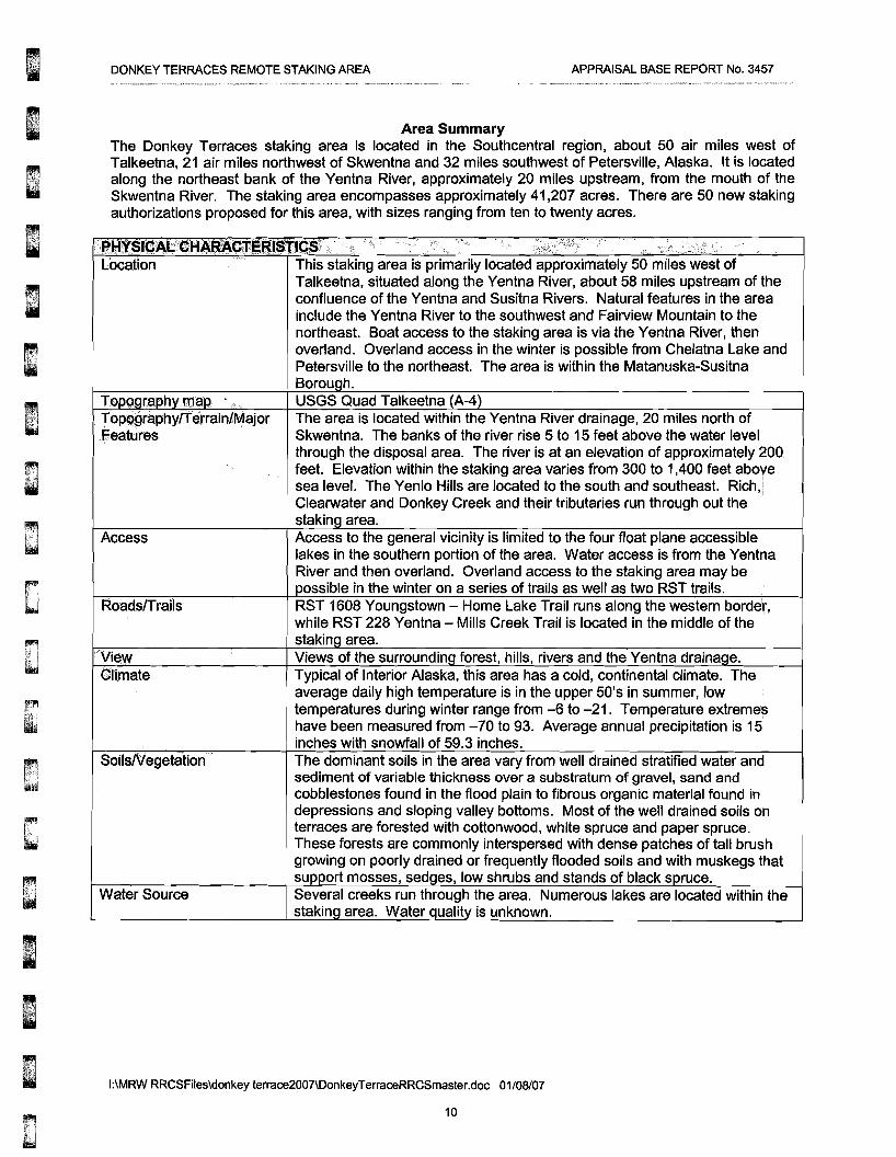
Area Summary The Donkey Terraces staking area is located in the Southcentral region, about 50 air miles west of Talkeetna, 21 air miles northwest of Skwentna and 32 miles southwest of Petersville, Alaska. It is located along the northeast bank of the Yentna River, approximately 20 miles upstream, from the mouth of the Skwentna River. The staking area encompasses approximately 41,207 acres. There are 50 new staking authorizations proposed for this area, with sizes ranging from ten to twenty acres.
i. ',. L,.~ -.:
;;;i~i;;)~';ir0;;~'.~~~liflil!$I~~[;;!;e;H~JI(r;m,III$11~$'f i' • i" r~ " ...",'rt". .,;;. Location
I
I
TOPQgr~phy rn~p
TOPQgraphylTe.rrainlMajor Features
Access
Roads/Trails
; View ~Iimate
SOilsNegetatiorl ~
Water Source
This staking area is primarily located approximately 50 miles west of Talkeetna, situated along the Yentna River, about 58 miles upstream of the confluence of the Yentna and Susitna Rivers. Natural features in the area include the Yentna River to the southwest and Fairview Mountain to the northeast. Boat access to the staking area is via the Yentna River, then overland. Overland access in the winter is possible from Chelatna Lake and Petersville to the northeast. The area is within the Matanuska-Susitna Borough. USGS Quad Talkeetna (A-4) The area is located within the Yentna River drainage, 20 miles north of Skwentna. The banks of the river rise 5 to 15 feet above the water level through the disposal area. The river is at an elevation of approximately 200
I feet. Elevation within the staking area varies from 300 to 1,400 feet aboye sea level. The Yenlo Hills are located to the south and southeast. Rlch.] Clearwater and Donkey Creek and their tributaries run through out the staklnq area. Access to the general vicinity is limited to the four float plane accessible lakes in the southern portion of the area. Water access is from the Yentna River and then overland. Overland access to the staking area may be possible in the winter on a series of trails as well as two RST trails. RST 1608 Youngstown - Home Lake Trail runs along the western border, while RST 228 Yentna - Mills Creek Trail is located in the middle of the staking area. Views of the surrounding forest, hills, rivers and the Yentna drainage. Typical of Interior Alaska, this area has a cold, continental climate. The average daily high temperature is in the upper 50's in summer, low
I temperatures during winter range from -6 to -21. Temperature extremes have been measured from -70 to 93. Average annual precipitation is 15 inches with snowfall of 59.3 inches. The dominant soils in the area vary from well drained stratified water and sediment of variable thickness over a substratum of gravel, sand and cobblestones found in the flood plain to fibrous organic material found in depressions and sloping valley bottoms. Most of the well drained soils on terraces are forested with cottonwood, white spruce and paper spruce. These forests are commonly interspersed with dense patches of tall brush growing on poorly drained or frequently flooded soils and with muskegs that support mosses, sedues, low shrubs and stands of black spruce. Several creeks run through the area. Numerous lakes are located within the staking area. Water quality is unknown.
I:\MRW RRCSFiles\donkey terrace2007\DonkeyTerraceRRCSmaster.doc 01/08/07
10
DONKEY TERRACES REMOTE STAKING AREA APPRAISAL BASE REPORT No. 3457
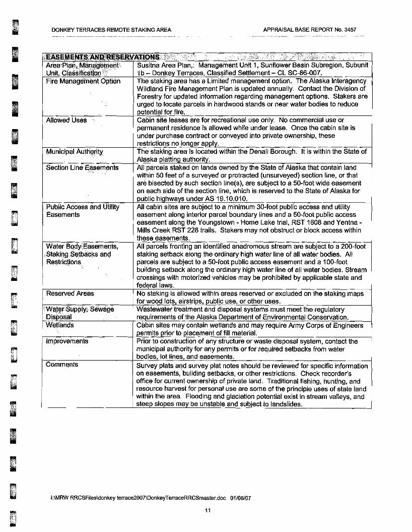
{.~EA,$E Area;P Susitna Area Plan,: Management Unit 1, Sunflower Basin Subregion, Subunit .Unit, Classific 'Ib - Donke Terraces, Classified Settlement - CL SC-86-007. Fire Management Option The staking area has a Limited management option. The Alaska Interagency
Wildland Fire Management Plan is updated annually. Contact the Division of Forestry for updated information regarding management options. Stakers are urged to locate parcels in hardwood stands or near water bodies to reduce
otential for fire. Allowed Uses Cabin site leases are for recreational use only. No commercial use or
permanent residence is allowed while under lease. Once the cabin site is under purchase contract or conveyed into private ownership, these restrictions no Ion er a I.
Municipal Authgrity The staking area is located within the Denali Borough. It is within the State of Alaska lattin authorit.
Section Line Easements All parcels staked on lands owned by the State of Alaska that contain land within 50 feet of a surveyed or protracted (unsurveyed) section line, or that are bisected by such section line(s), are subject to a 50-foot wide easement on each side of the section line, which is reserved to the State of Alaska for
ublic hi hwa s under AS 19.10.010. Public ACCess and Utility All cabin sites are subject to a minimum 30-foot public access and utility Easements easement along interior parcel boundary lines and a 50-foot public access
easement along the Youngstown - Home Lake trial, RST 1608 and Yentna Mills Creek RST 228 trails. Stakers may not obstruct or block access within these easements.
Water Bo,dY;;easements, All parcels fronting an identified anadromous stream are subject to a 200-foot Staki~g~~tbaeks a/J.Q staking setback along the ordinary high water line of all water bodies. All Restrictii'>ns.. . parcels are subject to a 50-foot public access easement and a 100-foot
building setback along the ordinary high water line of all water bodies. Stream crossings with motorized vehicles may be prohibited by applicable state and federal laws.
Reserved Areas No staking is allowed within areas reserved or excluded on the staking maps for wood lots, airstri s, ublic use, or other uses.
-. Water Supply; Sewage Wastewater treatment and disposal systems must meet the regulatory Dis osal re. uirernents of the Alaska De artment of Environmental Conservation. Wetlands Cabin sites may contain wetlands and may require Army Corps of Engineers
ermlts rior to .Iacement of fill material. Improvements Prior to construction of any structure or waste disposal system, contact the
municipal authority for any permits or for required setbacks from water bodies, lot lines, and easements.
Comments Survey plats and survey plat notes should be reviewed for specific information on easements, building setbacks, or other restrictions. Check recorder's office for current ownership of private land. Traditional fishing, hunting, and resource harvest for personal use are some of the principle uses of state land within the area. Flooding and glaciation potential exist in stream valleys, and stee slo es ma be unstable and subject to landslides.
I:\MRW RRCSFiles\donkey terrace2007\DonkeyTerraceRRCSmaster.doc 01/08/07
11

DONKEY TERRACES REMOTE STAKING AREA APPRAISAL BASE REPORT No. 3457
DATA ANALVSIS and CONCLUSION
Highest and best use analysis identifies the most profitable and competitive use of the property. Therefore, highest and best use is a market driven concept that is fundamental to the valuation of a property.
HIGHEST AND BEST USE
Highest and best use is defined as:
the reasonably probable and legal use of vacant land or an improved property that is physically possible, legally permissible, appropriately supported, financially feasible, and that results in the highest value.7
The highest and best use of a site must meet four criteria. The highest and best use of a property must be:
• legally permissible, • physically possible, • financially feasible, and • maximally productive.
The value of land is generally estimated as though vacant and available for development to its highest and best use. The appraisal of improvements (when present on the site) is based on their actual contribution to the total value of the property. The appraised property is vacant and unimproved.
HIGHEST and BEST USE of SITE as VACANT
Legally Permissible There are no local zoning laws limiting the development of this parcel. Development of well and septic systems must comply with the requirements of the Department of Environmental Conservation. The key parcel could be developed for almost any legal use.
Physically Possible The subject size and physical characteristics are adequate to support all reasonable and probable uses.
Financially Feasible Surrounding land use is primarily recreational. Development of the key parcel depends on the amount of resources the owner is willing to allocate for recreational needs.
Maximally Productive Surrounding land use is primarily recreational. Maximally productive use is the use that produces the maximum return from the proceeds of a sale or lease.
Highest And Best Use Of Land As Vacant Based on the foregoing analysis, the highest and best use of the subject parcel as vacant would be for almost any legal use, primarily a private recreation cabin site.
7 The Appraisal of Real Estate, Twelfth Edition, Appraisal Institute, 2001, p305
J:\MRW RRCSFiles\donkey terrace2007\DonkeyTerraceRRCSmaster.doc 01/08/07
12

DONKEY TERRACES REMOTE STAKING AREA APPRAISAL BASE REPORT No. 3457
SALES COMPARISON APPROACH
VALUATION PROCESS Three approaches are considered to determine the market value estimate.
INCOME APPROACH The income approach for valuation is used primarily for income producing properties. It utilizes the capitalization process to discount future anticipated net income to a present value. It is not common to lease vacant land for a residential or recreational use, therefore, data that supports this approach is not available.
COST APPROACH The cost approach is based on the assumption that an informed buyer would pay no more than the cost of producing a substitute property with the same utility as the subject property. This approach will separate the value of the land from the value of the improvements to determine the cost of reproducing the improvements. The cost approach is most effective for appraising properties that have newer improvements. The subject parcels lack any improvements. As such, this approach will not be used for this appraisal.
SALES COMPARISON APPROACH The sales comparison approach considers actual sales or prices asked for properties that have similar characteristics of the subject properties. Adjustments are made to the comparison properties so as to determine a price at which they would have sold if they had identical characteristics as the subject properties. This derived price then indicates a value for the subject properties. Some of the characteristics considered include general market conditions, sales terms, location, highest and best use and physical features. Only the sales comparison approach is applicable.
KEY PARCEL METHOD In appraising a number of similar parcels, it is accepted appraisal practice to appraise a key parcel that is most representative of all the parcels being appraised. The key parcel may be a hypothetical parcel or an actual parcel. The value of the remaining parcels is then based on a comparison to the key parcel. This methodology replicates typical developer thinking.
DESCRIPTION OF KEY PARCEL Lbcation Donkey Terraces Remote Staking Area Size 10 acres
151 L~t Type tier* parcel with frontage on unnamed float plane lakes. Access Float/ski plane to unnamed lakes BlAiiding Site' Average - At least 50% dry level ground, well-drained soils Utilities None Setbacks 100' ibuilding setback from MHW of all water bodies Easements 50' public access easement extending from ordinary high water mark.
Typital lot line easements or as requirred by plating authority. Amenities Water front view amenity
I:\MRW RRCSFiles\donkey terrace2007\DonkeyTerraceRRCSmaster.doc 02105/07
13

Due to the confidentiality of sales information in the state of Alaska, the valuation section of the report is unavailable online. The entire report can be reviewed at the DNR Public Information Center: In Anchorage (in the Atwood Building) 550 W. 7th Ave. Suite 1200, Anchorage AK, 99501 Phone (907) 269-8400 Fax (907) 269-8901 TDD for hearing impaired (907) 269-8411 e-mail: [email protected] Business hours 10:00 am to 5:00 pm M-F. In Fairbanks (Corner of University & Airport Way) 3700 Airport Way, Fairbanks, AK 99709 Phone (907) 451-2705 Fax (907) 451-2706 TDD for hearing impaired (907) 451-2770 e-mail: [email protected] Business hours 10:00 am to 5:00 pm M-F. In Juneau (Southeast Div. of Land) 400 Willoughby Ave., 4th Floor, Juneau AK 99801 Phone (907) 465-3400 Fax (907) 586-2954 e-mail: [email protected] Business hours 10:00 am to 5:00 pm M-F.