attachment 3 project summary/history of chevron...
TRANSCRIPT

Attachment 3 Project Summary/History of Chevron Guadalupe Restoration Project
This document provides a summary of the Guadalupe Restoration Project, including background information on the project, clean up and restoration work that has been completed to date, and what work is still outstanding at the site.
The Guadalupe Restoration Project has been a model of Agency and Applicant cooperation. The Multi-Agency Coordinating Committee (MACC) was formed to oversee the restoration and remediation at the Guadalupe site. The MACC is comprised of Chevron and all of the governmental agencies that have issued permits for the restoration and remediation work. This cooperation has resulted in very successful remediation and restoration at the site. In particular, the wetland creation program at Guadalupe has been recognized as one of the most successful in the state of California.
Union Oil of California (Unocal) was the operator of the Guadalupe Oil Field, and the party responsible for beginning the remediation work at the site. In 2005 Chevron bought Unocal and took over the work at the Guadalupe site. For the remainder of this document the operator of the site is referred to as Chevron.
A. Background
The Guadalupe site occupies over 2,700 acres of the larger Nipomo Dunes Complex and is located on the Central California Coast. The majority of the site is located in San Luis Obispo County, with a small portion located in Santa Barbara County.
The site is a very sensitive ecological area that is home to a number of
Created Wetland at D14

Attachment 3 Background on Site Contamination The principal land use at the Guadalupe site, from 1946 to March 1994, was the production of oil and natural gas. In the 1950s, a petroleum hydrocarbon referred to as diluent was used to assist in the production of the heavy crude oil. Diluent is similar to kerosene. Diluent use ceased in 1990. Over the years, diluent was inadvertently released from the pipelines and storage tanks, and diluent sources are now present in soils and the ground water at the Guadalupe site.
Response to Initial Release of Contaminants Between 1988 and early 1990 diluent was spotted on beach sands and on some ground surfaces at the site. This resulted in site investigation work to determine the cause and extent of the diluent leaks at the site. Between 1992 and 1994 diluent was observed being released into the ocean. Diluent is a toxic material to humans, wildlife and plants, and therefore represented a risk to ecological and human health.
In February 1994 the United States Coast Guard issued a directive to prevent any further marine releases of diluent because it represented an imminent threat to the marine environment. In 1994, a large excavation project called 5X began at the beach to attempt to stop the marine releases of diluent. This excavation was overseen by a number of Federal, State and local agencies and was done under emergency permits.
In 1994, the Regional Water Quality Control Board (RWQCB) requested that further site investigations be conducted to determine the extent of the diluent contaminated soil, groundwater, and surface water. The results of this site assessment showed that there was extensive groundwater contamination with more than 80 different locations throughout the field that had underground plumes of diluent (see Figure on next page). These areas of contamination represented a threat to the sensitive ecological resources at the Guadalupe site.
Permitting History
5X Beach Excavation Site During Storm Event

Attachment 3 Obispo County then issued CDP/DP D890558D, which covered remediation and abandonment activities at the Guadalupe Field. This CDP/DP authorized remediation and site characterization activities at the Guadalupe oil field consistent with CAO 98-38 adopted by the RWQCB, and permitted the removal and abandonment of site infrastructure such as roads, pads, pipelines, etc.
Permits for the remediation and restoration work were also issued by the California Coastal Commission (CCC), the California Department of Fish and Wildlife (CDFW), the United States Army Corps of Engineers (USACE), the United States Fish and Wildlife Service (USFWS), and the San Luis Obispo County Air Pollution Control District (SLOAPCD).
Permit Monitoring Requirements As part of the San Luis Obispo County CDP/DP permit, Chevron is required to fund through the County independent monitors to assure that the work at the site complied with all the County conditions of approval. In addition, the CCC, the RWQCB, the CDFW, and the USFWS permits require monitoring. All these agencies agreed to use the County monitors for their on-site monitoring requirements. This served to streamline the on-site monitoring process and reduce the overall monitoring costs.
The County monitoring contract covers on-site monitors, as well as time for reviewing and approving (1) excavation and wetland restoration engineering drawings, (2) work plans, and (3) a large number of compliance and reporting documents required by various governmental agency permits. In addition, the monitoring contract includes time for the preparation of CEQA documents to address project modifications, which tend to occur with a project this large and complex. To this end, the monitoring budget includes time needed to complete an EIR addendum to evaluate Chevron’s request to revise the truck haul route that would include a northern route through the Nipomo Mesa (Highway 1 north to Willow Road to Highway 101 south).
As required by most of the agency permits, including the County, monitors must be on-site for Chevron to conduct remediation and restoration activities. The on-site monitors include wildlife biologists, botanists, construction engineers, and chemical engineers. In addition, the monitoring includes a full-time Western Snowy Plover monitor during the breading season, which is a requirement of the USFWS permit.
The County on-site monitors work closely with Chevron and the various governmental agencies to assure that the work is completed in an environmentally sound manner consistent with all of the various agency permit conditions.

Attachment 3 issues. Guadalupe was the first project to establish a MACC to coordinate agency and applicant interaction on a project. The use of the MACC has been instrumental in building a strong working relationship between the applicant, the County monitors, and the various governmental agencies, and has been one of the keys to the success of the project.
As required by various permit conditions, Chevron has established irrevocable protective easements over the Guadalupe site and is required to eventually dedicate the land to a public agency or private non-profit association as open space for habitat protection. It is likely this dedication would occur once the remediation and restoration of the site is complete in approximately five to ten years.
B. Remediation and Restoration Activities Completed To Date
The Cleanup and Abatement Order issued by the RWQCB required cleanup and restoration of the Guadalupe site in phases. Chevron is nearing the completion of Phase I of the cleanup and restoration. The majority the cleanup work to date has involved the excavation of contaminated soil. Excavation work at the site is complicated by the sensitive ecological conditions of the site and the significant number of rare and endangered species. Further complicating a number of the excavations has been that fact that they were located in Federal and State Wetlands.
A substantial amount of cleanup and restoration has taken place at the Guadalupe site. Figure 1 shows the location of the excavations that have occurred at the site since remediation work began. The work that has
Excavation Work at M12

Attachment 3
Page 5 of 12 28-May-15
Figure 1 Location of Excavated Sites and Remaining Excavation Sites at the Guadalupe Site

Attachment 3
Loading Truck with Contaminated Soil for Transport to
the Santa Maria Landfill
A total of about 1,055,000 cubic yards of contaminated soil has been hauled to the Santa Maria Landfill for use as cover to assist in closure of the landfill. The California Department of Toxic Substance Control (DTSC) has determined that the material from the Guadalupe site is suitable for use as cover material at the Santa Maria Landfill.
About 150 miles of pipeline have been removed from the site.
Over 20 acres of wetlands have been created.
Typically two County monitors are on-site four to five days per week to monitor the remediation and restoration activities. Most of the time, multiple remediation and restoration activities are occurring at one time, which requires multiple on-site monitors in order to comply with various governmental agency permit conditions.
The working relationships that have formed between Chevron, the governmental agency staff and the County monitors have resulted in the design and implementation of excavations that have minimized impacts to the sensitive ecological resources, and the creation of wetlands that support large numbers of rare and endangered species.
The wetland creation program at Guadalupe has been recognized as one of the most successful in the state of California. This project has set a model of how agencies and an applicant can work together to implement a large and complex project. Attachment A provides various pictures of remediation and restoration work at the Guadalupe Site.
C. The Next Steps at the Guadalupe Site
Currently a number excavation projects and restoration projects are under way at the site. There are still a number of excavations that need to be completed as part of the requirements of the

Attachment 3 various methods of pad removal or treatment in place. Treatment included various forms of ripping of the asphalt road or red-rock pad site, leaving that material in place, and covering the ripped road or pad with clean sand for future habitat restoration. The results of this test program were reviewed and approved by the County staff and agency reviewers in 2014, and are currently being put into action under the 2015 PROS Program Work Plan. It is expected that the treatment and removal of roads, pads and oil spray areas will take two to four years to complete.
Chevron is also required to monitor the created and restored wetlands, and restored upland habitat for a period of ten years to assure compliance with the restoration success criteria that have been approved by various governmental agencies including the County. As required by various governmental agency permits, the independent third party County monitors are required to be on-site until all remediation and restoration work at the site is complete.

Attachment 3
Page 8 of 12 28-May-15
Various Stages of an Excavation
Excavation Vegetation Removal
Backfill
Sheetpile Installation
Recontouring Final Grade Fencing and Replanting

Attachment 3
Page 9 of 12 28-May-15
Various Phases of B12 Excavation
B12 Wetland Created February 2010
B12 Wetland Final Grade January 2008
B12 Wetland Excavation December 2007
Attachment 3
Page 10 of 12 28-May-15
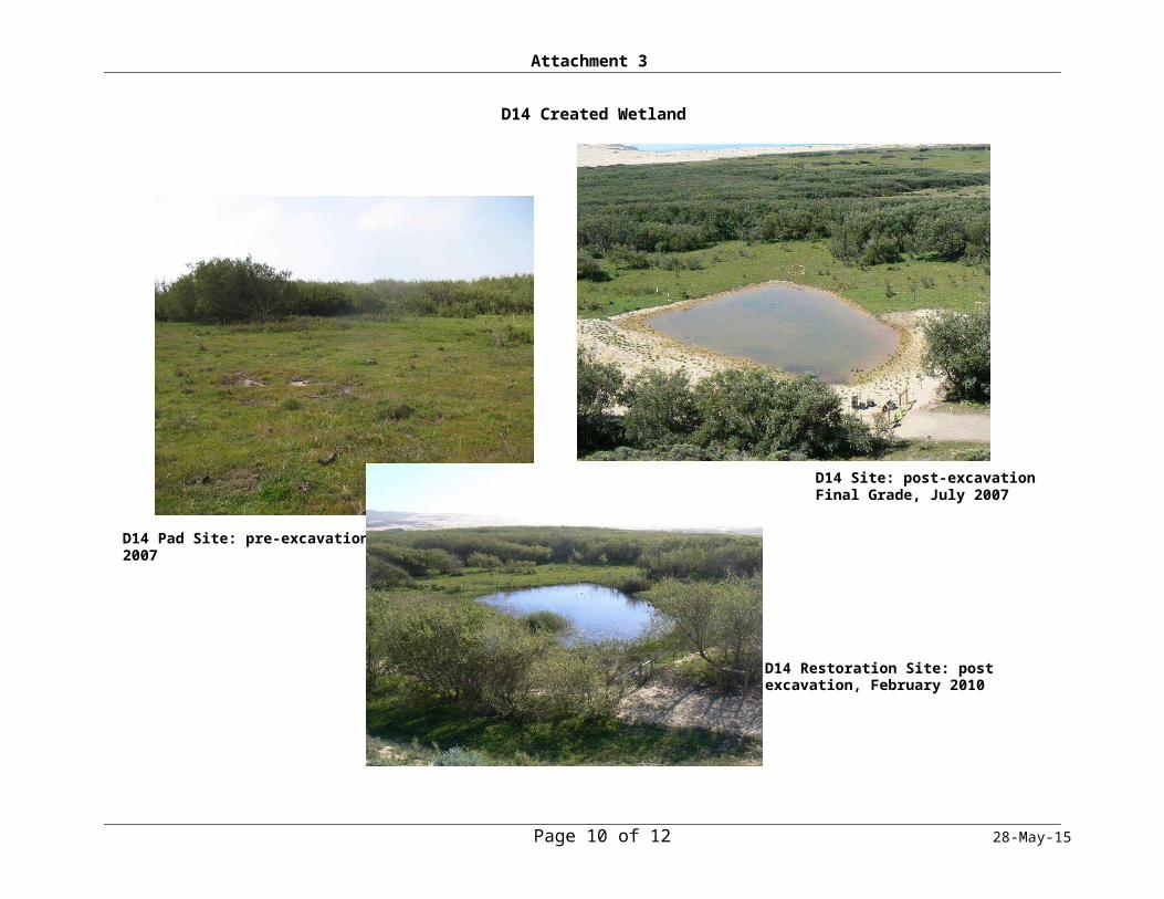
D14 Created Wetland
D14 Pad Site: pre-excavation, June 2007
D14 Site: post-excavation Final Grade, July 2007
D14 Restoration Site: post excavation, February 2010

Attachment 3
Page 11 of 12 28-May-15
Typical PROS Program Treatment Activities
Sump removal during treatment of Pad
Post Excavation: sump removal during treatment of Pad ZH5 Excavation Area (before): immediately after excavation.
Breaking up concrete slab, which will be excavated and site will be restored

Attachment 3
Page 12 of 12 28-May-15
Typical PROS Program Treatment Activities
P3 Road near Main Office (same road as previous photo): after treatment and sand placement
ZH5 Excavation Area (after): after excavation, backfill, grading, and placement of vegetation and installation of BMPs
P3 Road near Main Office: after treated (asphalt and red-rock base material broken up)