assessing the impact of agricultural land use changes on water quality
TRANSCRIPT

e> Pergamon
PIT: S0273-1223(99)00423-0
Waf. Sci. Tech. Vol. 40, No.2, pp. 1-10, 1999CI999IAWQ
Published by Elsevier Science LtdPrintedinGreatBntain.All rightsreserved
0273-1223/99 520.00 + 0.00
ASSESSING THE IMPACT OFAGRICULTURAL LAND USE CHANGESON WATER QUALITY
R. Meissner, 1. Seeger, H. Rupp and H. Balla
UFZCentrefor Environmental ResearchLeipzig-Hal/e, Department ofSoil Sciences,LysimeterResearchStation, Dorfstrasse55, D-39615Falkenberg, Germany
ABSTRACT
To study and predict environmental impacts of land use changes on water quality we conducted differenttypes of Iysimeter experiments. All of them are linked to representative experimental catchment areas in thefield. This allows the verification and extrapolation of Iysimeter results. The objective of this paper is todiscuss a strategy for using and scaling-up of lysimeter results to a field and catchment scale. It will beshown that the N-loss determined with lysimeters falls within the variation of N-balance based modelcalculations, and also within ground water recharge rates calculated with models conunonly used inhydrology. Extrapolation of lysirneter data to a catchment with similar soils provides a reliable basis forestimating the N-leaching caused by a change in agricultural land use. On the basis of the N-loss from thesoil and the N-Ioad of the stream, the calculations show that an increase in the proportion ofone year rotationfallow from 10 to 25% results in nearly a 10% increase in the N-Ioad of the stream. However, from the pointof view ofprotecting drinking water quality, rotation fallow for one year is not reconunended because of theresulting intensified leaching of nitrates. C 1999 IAWQ Published by Elsevier Science Ltd. All rightsreserved
KEYWORDS
Landuse change; lysimeterexperiment;nitrogen;scaling-up;set-aside;water balance
INTRODUCTION
Recent studies have shown that in Germany agriculture is directly responsible for more than 50% of thenitrogen(N) leachedinto streamsand rivers. This takes place primarilythrough a diffusesoil - groundwater- surfacewaterpathway(Novotny, 1995).
Gennan reunificationin October 1990 brought about a transformation in the structureof agriculture in theformerGDR. East Germanybecame a part of the EuropeanCommunityand subject to the Union's commonagricultural policies. These policies call for reducing agricultural overproduction. In the eastern part ofGermanyas much as 10% of the 6.2 million hectares of previously intensivelyfarmed areas were set asideby 1991.
Past intensive land use resulted in an accumulation of nutrients and agrochemicals in the soil. Thisrepresents a significantpotentialrisk for the qualityofboth surfaceand groundwaters (Hekstra, 1995).Thispotential environmental problem becomes more acute if it is taken into account that in the eastern part ofGermany most ground water recharge takes place in agricultural areas and that more than 70 % of the

2 R. MEISSNERet al.
drinking water supply comes from ground water. Therefore, it is of vital interest to know the quality andquantity of seepage water which leaves the root zone, then enters the aquifer and finally the surface watersystem. This knowledgewill help to define changes in land use and fanning methods which can contributeto an improvement in water quality.
MATERIALAND METHODS
In the last few years a lot of work has been done in Germany to describe the pathways of pollutants fromnon-point sources. At this time rough estimatesof nutrient budgets (especiallynitrogen and phosphorus)areavailable for the most important river systems. But there is a gap in our knowledge about the assessmentofvarious land management methods on water quality (Mohaupt and Behrendt, 1997). Solving the problemwith investigations of whole river systems only is not possible, because they are very heterogeneousand aseparationof important impact factors is almost impossible. In our opinion it is better to work on differentscales and try to explain the relevantprocesses.
For this reason we carried out lysimeter trials to get informationon how different land managementmethodsinfluencethe amount and quality of seepage water. In the next step we tried to find this result in a field and a(small) catchmentscale, because we are interested in how different types of land management influence thequality of groundwater (after leaving the root zone) and surface water (after transport in the saturatedzone).At the same time we tried to validate the Iysimeter data at the field and catchment scale and to use themeasured data for comparisonwith, and improvementof, models. In this paper we will give an example ofthis strategy. Because N (especially nitrate) is the most important criterion for drinking water quality inGermanywe will demonstratethe results for this nutrient.
RESULTS
Lysimeterscale
Lysimeter studiesThe UFZ Centre for Environmental Research operates 200 Iysimeters at 6 Iysimeterstations and at 3 sites(Falkenberg, Colbitz, Brandis) in typical regions of the Elbe river catchment (Meissner et al., 1998a). AllIysimeter experiments are linked to experimental catchment areas in the field to establish and verifyextrapolationdomains.The UFZ LysimeterResearchStation in Falkenbergrepresentsthe Elbe catchment inthe northem regions of the states of Saxony-Anhalt and Brandenburg. One hundred and twenty nonweighable lysimeters each with a surface area of 1 m', a total depth of 1.25 m and free drainage wereconstructed in 1983. The Iysimeterswere filled with disturbed soil profiles (sandy loam, sand, loam, loess)commonlyfoundin the catchmentarea of the Elbe river and the northem part of Germany.
In the spring of 1991 a Iysimetertrial, originally designed in 1983 to maximize yields, was adapted to thesenew conditions in agricultural land use. The purpose of the trial was to investigate the impact of thestructuralchanges in agricultural land managementon the water and solute balance. The seepage water fromthe Iysimeters was collectedcontinuouslyin storagecontainersand then pooled to obtain a mixed sample forevery month.
The land use change experimentsincluded30 Iysimeters:
10 Iysimeters were treated as permanent fallow(beginningon August 1, 1991);10 Iysimeters were treated as rotation fallow for one year (the first fallow period was implementedfromAugust 1,1991 to July 31,1992) before resumingintensive crop cultivation;10 Iysimeters were treated according to Best Management Practices (BMP), whereby fertilization andirrigationis done in accordancewith the plant's requirement for nutrients and water as well as ecologicaland economicdemands.
The N-Ioad (!: NOJ-N + N02-N + Nl4-N) in the seepage water from the three Iysimetergroups is shown inFigure 1.

Assessing the impact ofagricultural land use changes on water quality 3
1992193
m Permanenlfallow
1993/94
Rolation fallow
1994195
Figure J. Annual N·load in the seepage water as a function of the farming scheme.
The lysimeter tests furnished proof that restricting agricultural use of areas, previously fanned intensively,by converting them into permanent fallow or rotation fallow will result in measurable changes in the waterand solute balance within a short period oftime (Meissner et al., 1998b). In this respect it is interesting thatin year 1991/92 a significantly increased loss ofnitrate occurred in the set-aside lysimeters as compared withBMP. This is due to the fact that the plant stands, which were newly establishing themselves on the fallowtreatments, withdraw less nitrogen. The surplus of nitrogen contained in the soil originates from previousintensive cultivation and cannot be utilized sufficiently by non-agricultural plants. Consequently, thisnitrogen is leached with the seepage water. Due to the depth of the lysimeters used in the test and a lack ofmineral fertilization, the set-aside treatments showed a clear reduction ofnitrate leaching as early as 1992/93compared with BMP. In the case of the permanent fallow, this trend continued in 1993/94 and 1994/95. Thehigher level in 1993/94 was due to increased mineralization caused by the weather. In contrast, the rotationfallow was stopped and intensive fanning resumed. Intensive fanning was associated with a considerableincrease in nitrate leaching in the test years 1993/94 and 1994/95 due to resumed mineral fertilization andsoil cultivation which contribute to increased mineralization. It is important, with regard to the protection ofthe ground water resources, that the highest nitrate leaching loss was measured after four years of trial underrotation fallow, and even in the case of permanent fallow the total amounts of leaching nitrate wereapproximately 23% below the values for BMP.
Using the lysimeter data/or modellingThe simulation model CANDY (Carbon and Nitrogen Dynamics), which was developed in the UFZ,describes all important soil processes concerning the C-N- dynamics in rural landscapes (Figure 2).Important inputs are soil physical properties, meteorological data and management information. The modelworks in daily time steps and produces outputs concerning relevant ecological information (Franko, 1996).Because lysimeters produce real data about the leaching process they are ideally suited for the validation ofmodels. Since 1992 we have conducted special investigations to compare measured and calculated water andsolute balances. A comparison of measured and calculated' N-Ioads for two agriculturally used lysimeters(replications with the same crop rotation) from the Lysimeter Research Station in Falkenberg is given inFigure 3.

4 R. MEISSNER et al.
puramete rs.\ im utation " 1IIt1,,/
nv i ro nment
c mp <k\ ef opm ent
O :\\ - I u n ltl \ er! N-d) nami e l
driving fo rce
initia liz ation
~nilial \alu ..,
Figure 2. Stru cture of the simula tion model CANDY (acco rding to Franko, 1996).
30 r-- - - - - - - - - - - - - - - - - - - - - - - - - - - - -,
25
20
i..,c: 15
•'0~ 10Z
5
N N N N N N ... ... ... ... ... ...~ ~ ~ ~ ~ ~ '" '"... ... ... ... ... ... ... ... ... ... ... ... ... ...... ... ...
~... ... ... ~
... ... '" ... ... ... e ... ... ... '" '"~ ~ ~ ~ ~ ~ ~ ~ ~ ~ ~ ~
,.; .,; ,.; '" ~ ,.; .,; ,.; '" ~ ,.; .,; ,.; '" C!,.;
~ ~ ~ ~ 0 ~ ~ ~ ~ ~ 0 ~ ~ ~ ~ ~ 0 ~ ~~ ~ ~ ~ 0 0 ~ ~ ~ - 0 0 ;:; ~ ~ ~ 0 0 ~ ~... ... ... ... ... ... ... ... ... ... ... ... ... ... ... ... ... ... ...
Figure 3. Comparison ofN-loads measured with Iysimeters and calculated with the simulation model CANDY.
Comparing the N-Ioads measured with the Iysimeters and calculated with CANDY reveals differences in theyears 1992 and 1993. Since 1994 the N-Ioads calculated with CANDY fall within the range of valuesobserved in Iysimeters.

Assessingthe impact of agricultural1and use changeson waterquality
o®
©
N -
Figure4. Geographicallocationof the experimentalcatchmentarea 'Scbaugraben' inside the Elbe catchmentandthe UFZ managedlysimeterstations.
Field and catchment scale
5
Schaugraben catchmentWith the aim of scaling-up and of calculating the effects of set-aside under natural conditions, the results ofthe lysimeter studies were extrapolated to a small catchment area about 15 km from the lysimeter station,which corresponds to the location of the Iysimeter both in relation to meteorological factors as well as inrelation to pedological parameters. The main stream in this experimental area is called the Schaugraben. TheSchaugraben is a tributary of the Elbe river in north-east Germany (Figure 4). The basin is largely

6 R. MEISSNER et al.
agricultural with the exception of the forested headwaters. The catchment area was subdivided into fourpartial catchment areas. Four gauging stations were equipped; discharge and water quality were measuredtwice monthly at each site from October 1992. At the outlet of the Schaugraben stream (subcatchment 4)discharge and water quality have been monitored automatically since May 1997. Historic and recent land use patterns (i.e. forest, pasture and arable land along with type of crops and fertilization regime) in theSchaugraben catchment have been quantified since 1991 and mapped in a GIS. The type of land use is animportant consideration when attempting to quantify and predict nitrate leaching. Figure 5 gives anoverview of land use change in the experimental catchment after reunification of Germany. The increase ofthe share of rotation fallow for one year is important. This kind of land use was unknown under the formerconditions ofco-operative farming.
o
I I I If:::::::::::::::_
i I t i I I I II~:
1 . I · I I f !I
V
i i · I I I II
. . f 1 I i..
I · i I I iI iE:::::::::
- I I I I I I iE:::::::::
I I I I
1997
1996II
19 4
199 3
11 92
119 1
I
I10% 20%
Pasture Forres t
c Sugar be ts IJAltalfa
30% 40%
raS aled
• Potatoes
50% 0%
II Set aside
• Rape seed
70%
. Cereal
Other
80% 0%
&:I Corn
• Not classified
100%
Figure 5. Land use changes in the experimental catchment Schaugraben.
Comparison oflysimeterandfield investigationsThe scaling problem is very important in the comparison of Iysimeter and field results. In addition to thelysimeter measurement we carried out special field investigations in catchments with compatible soils. Asmentioned above we found a considerable increase in nitrate leaching in the Iysimeter after stopping therotation fallow and resuming intensive farming (compare Fig. I; years 1992/93 and 1993/94). On the fieldscale we measured the plant available nitrate content in the soil (Nmin) every month. Figure 6 shows thatafter a fallow period and a subsequent planting of corn on this field in May 1994 the Nmin content in thesoil increased. In the future this will lead to an increase in nitrate leaching. It can be shown that the effect wemeasured in the lysimeter occurs on the field scale, too.
Applicationoflysimeterresults to the experimentalcatchmentWater balance. As a precondition for extrapolating the results of the lysimeter trials, a comparison was madebetween the amount of seepage water measured in the lysimeters and ground water recharge in the area ascalculated with models commonly used in Germany (Table I). As expected, discrepancies were foundbetween the calculated values and the values obtained with the lysimeters. But the seepage water quantitiesdetermined with the lysimeter fall within the range of the calculated ground water recharge rates.

Assessing the impact ofagricultural land use changes on water quality 7
20
0 t". t". ... ... ... ... ... ,.. ... ... ,.. '.. ' .. '.. -r .. -s .. -r -r .. -ra- 0- 0- a- a- a- a- a- a- a- a- a- a- a- a- 0- a- a- a- a- I'" a-
r- e- ... (; '" 8 00 a- 0 t", ,.. (; '" -0 " 00 s0 0 0 0 0 0 0 0 0 0 0 0 0
1.sI1'1\\ (t-rn
1-10
120
100i..-:!
I 80
] 60~0:L. 40
Figure 6. Comparison ofsoil N03-N (0-90cm) of two cropped sites and a fallow site after the resumption ofintensive farming.
Table 1. Comparison of results from long-term lysimeter studies and calculated mean annual ground waterrecharge in the Schaugraben catchment
Calculated rechareeModel "RASTER" T)
Bagrov-Glugla" I) 95 -1-1Renger-Wessolek I) 87 15 11Doerhoefer-Josopait I) 96 16 IILong-term Iysimeter 72 23 2studies
Reference Arable land··(14.83 km2
)
Pastures"(5.23 km2
)
Forest··(3.74 km2
)
~ Ground waterrechargee"(23.80km2
)
12593
11312397
·Long- term mean precipitation at the Falkenberg lysimeter station: 504 mmLong-term mean evaporation rate at the Falkenberg lysimeter station: 565 mm•• Ground water recharge in mmI) See References
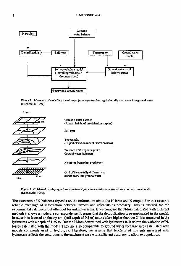
Solute balance. On the basis of the results of the lysimeter studies and the land use in the catchment, anestimate ofN-loss from the soil was made for several hydrological years. We compared these results with aGIS added version of a N-balance model (Table 2), developed and adapted from Dannowski (1997). Thescheme ofthe model and the structure of the GIS-based calculation are shown in Figures 7 and 8.
8 R. MEISSNER et al.
Climaticwaterbalance
Soil water/solute model(Travellingvelocity,N
decomposition)
IN entry into groundwater
Groundwatertable
Groundwaterdepthbelow surface
Figure7. Schematicof modellingthe nitrogen(nitrate)entry from agriculturallyused areas into groundwater(Dannowski, 1997).
2Skm
SOm
Climaticwaterbalance(Annualheightof precipitationsurplus)
Soil type
Topography(Digitalelevationmodel, watercourses)
Presenceof the upper aquifer,Ground water isohypses
N surplus fromplant production
Grid of the spatiallydifferentiatednitrateentry into groundwater
Figure8. GIS-basedoverlayinginformationto analysenitrateentries into groundwateron catchmentscale(Dannowski, 1997).
The exactness of N-balances depends on the information about the N-input and N-output. For this reason areliable exchange of information between farmers and scientists is necessary. This is ensured for theexperimental catchment but often not for unknown areas. Ifwe compare the N-Ioss calculated with differentmethods it shows a moderate correspondence. It seems that the denitrification is overestimated in the model,because it is focused on the top soil (soil depth of0.5 m) and is often higher than the N-Ioss measured in thelysimeters with a depth of 1.25 m. But the N-Ioss determined with Iysimeters falls within the variation ofNlosses calculated with the model. They are also comparable to ground water recharge rates calculated withmodels commonly used in hydrology. Therefore, we assume that leaching of nutrients measured withIysimeters reflects the conditions in the catchment area with sufficient accuracy to allow extrapolation.

Assessing the impact of agricultural land use changes on water quality 9
Table 2. Comparison ofN-loss from the soil for the different subcatchments of the Schaugraben catchmentbased on model calculations and lysimeter results (N-loss in kg/ha).
Subcatchments of the Schaugraben SCI SC2 SC3 SC4612 ha 800ha 793 ha 210ha
N-balance modelN surplus at the soil surface 1993 28 46 40 12
N surplus at the soil surface 1994 19 35 42 33N surplus and denitrification factor"
for the upper soil 1993 16 26 20 4
N surplus and denitrification factor"for the upper soil 1994 8 19 22 22
Lysimeter resultsMeasured N-loss 1993 46 43 42 40
Measured N-loss 1994 17 26 27 11
OJ according to Kohne and Wendland (1992)
Comparison between N-/oss from the soil and N-/oad ofthe streamBased on annual results of the lysimeter studies (N leached in drainage water) and the actual land use in thecatchment (crops planted, fallow, pasture, forest) an estimation ofN-loss from the soil was made for eachyear. Based on the discharge measured at 4 gauging stations and analyses of its N-content, the annual loadwas calculated for the whole Schaugraben catchment (Table 3).
Table 3. Comparison of estimated N-loss and calculated N-load of the Schaugraben.
Year') Annualprecipitation N-lossfromthe soil(mm) (kg)
1993 701 577601994 762 1070701995 505 610701997 434 229501998 650 42470*) 1996: no datadueto longand severefrostperiod
N-loadof the stream(kg)
2661076350280807950
17150
Differences N-lossIN-load(kg)
3115030720329901500025320
The N-loss from the soil and N-load of the stream at the bottom of the catchment reveal a difference ofbetween 29 and 65%. The observed reductions agree reasonably well with postulated - but at this time notmeasured - factors in the literature (Behrendt, 1995). The most important reason for these differences isprobably the highly variable hydrological regime. At present the whereabouts of these amounts ofN cannotbe determined precisely. In future work we will start experiments with conservative tracers (Cl and Br),stable isotopes e~, D20 ) and natural isotope signatures eH, 180 , l~, 34S) to explore the pathways andtransformation ofN during transport from soil surface via ground water to the surface water.
On the basis of the above findings we estimated the effect of rotation fallow (only this kind of fallow waspresent in the experimental catchment) on the N-load of the Schaugraben. An increase in the proportion ofrotation fallow from 10 to 25% would have raised the N-Ioad in the Schaugraben stream by about 10%.
CONCLUSIONS
Changing previously intensively farmed agricultural areas to fallow will result in increased deep percolation,at least in the first year of set-aside. In addition, extra leaching ofN contained in the soil will occur.
From the point of view of protecting drinking water quality, one year rotation fallow is not recommendedbecause of the resulting intensified leaching ofnitrates.

10 R MEISSNER et al.
Lysimeters allow a realistic simulation of a wide range of scientific and practical questions on the small andmedium scale. Lysimeters are ideal research facilities to explore environmental impacts of landmanagement, to develop and test simulation models and to design sound and feasible management practices.
REFERENCES
Behrendt, H. (1995). Changing Estuarine and Coastal Environments. Proceedings EERO Workshop, GKSS Research CenterGeesthacht, Germany, 35-44.
Dannowski, R(1997). Diffuse entries in rivers of the Odra Basin. In: PANIDVWK Joint Project, Final Report, Okrusko, H. andDirksen, W. (Eds), ZALF Muencheberg.
Doerhoefer, G. and Josopait, V. (1980). Eine Methode zur flachendifferenzierten Ermittlung der Grundwassemeubildungsrate.Geol.Jahrb. Series C, 27, 45-65.
Franko, U. (1996). Model1ing approaches of soil organic matter turnover within the CANDY System In: Evaluation of SoilOrganic Matter Models Using Existing Long Term Datasets, D.S. Powlson, P. Smith and I.U. Smith (Eds), Springer,Berlin, Heidelberg, 247-254.
Glugla, G. (1978). In Angewandte Hydrologie, Dyck, S. (Ed.), Vol. 2, Verlag filrBauwesen, Berlin, Germany, 318-342.Hekstra, G. P. (1995). Delayed Effects of Pollutants in Soils and Sediments: Understanding and Handling of Chemical Time
Bombs in Europe. StichtingMondiaalAlternatief, Amsterdam, 46pp.Klihne, C. and Wendland, F. (1992). Modellgestlitzte Berechnung des mikrobiellen Nitratabbaus im Boden. Internationaler
Bericht KFA-STE-m-1/92.Meissner, R, Seeger, 1. and Rupp, H. (I998a). Lysimeter studies in East Germany concerning the influence of set aside of
intensively farmed land on the seepage water quality. Agriculture,Ecosystems & Environment67, 161-173.Meissner, R., Seeger, 1. and Rupp, H. (1998b). Measuring Environmental Impacts of Land Use Changes on Water Quality with
Lysimeters. In: The Lysimeter Concept- Environmental Behavior of Pesticides, Fllhr, F. et al. (Eds), ACS Books(American Chemical Society). Series No. 699, Chapter 12, p. 163 - 176.
Mohaupt,V. and Behrendt, H. (1997). Kenntnisstand llber diffuse Quellen von Nahrstoffen, Pestiziden und Schwennetallen.Proceedings IKSE-Workshop Bewertung der Ergebnisse aus der Elbeschadstofforschung, GKSS-ForschungszentrumGeesthacht, Germany, 154-164.
N-A-U- Karle (RASTER) (1958). Grollblatter der Topographischen Obersichtskarte (Mallstab 1:200000); Institut filrWasserwirtschaft, Berlin.
Novotny, V. (1995). Diffuse (Nonpoint) Pollution - a New Chal1enge to Environmental Profession. Vodni Hospodarstvi, CzechRepublic, Vol. 6-7, 168-170.
Renger, M. and Wessolek, G. (1990). Auswirkungen von Grundwasserabsenkungen und Nutzungsanderung auf dieGrundwassemeubildung. Mitt. d.Jnst.f; Wasserwesen; 386, 295-305.