archeological investigations and national register testing
TRANSCRIPT

Volume 2007 Article 9
2007
Archeological Investigations and National Register Testing at Archeological Investigations and National Register Testing at
41CV1636, Coryell County, Texas 41CV1636, Coryell County, Texas
John E. Dockall
Jennifer K. McWilliams Texas Historical Commission, [email protected]
Karl W. Kibler Cross Timbers Geoarcheological Services, [email protected]
Follow this and additional works at: https://scholarworks.sfasu.edu/ita
Part of the American Material Culture Commons, Archaeological Anthropology Commons,
Environmental Studies Commons, Other American Studies Commons, Other Arts and Humanities
Commons, Other History of Art, Architecture, and Archaeology Commons, and the United States History
Commons
Tell us how this article helped you.
Cite this Record Cite this Record Dockall, John E.; McWilliams, Jennifer K.; and Kibler, Karl W. (2007) "Archeological Investigations and National Register Testing at 41CV1636, Coryell County, Texas," Index of Texas Archaeology: Open Access Gray Literature from the Lone Star State: Vol. 2007, Article 9. https://doi.org/10.21112/ita.2007.1.9 ISSN: 2475-9333 Available at: https://scholarworks.sfasu.edu/ita/vol2007/iss1/9
This Article is brought to you for free and open access by the Center for Regional Heritage Research at SFA ScholarWorks. It has been accepted for inclusion in Index of Texas Archaeology: Open Access Gray Literature from the Lone Star State by an authorized editor of SFA ScholarWorks. For more information, please contact [email protected].

Archeological Investigations and National Register Testing at 41CV1636, Coryell Archeological Investigations and National Register Testing at 41CV1636, Coryell County, Texas County, Texas
Licensing Statement Licensing Statement This is a work for hire produced for the Texas Department of Transportation (TxDOT), which owns all rights, title, and interest in and to all data and other information developed for this project under its contract with the report producer. The report may be cited and brief passages from this publication may be reproduced without permission provided that credit is given to TxDOT and the firm that produced it. Permission to reprint an entire chapter, section, figures or tables must be obtained in advance from the Supervisor of the Archeological Studies Branch, Environmental Affairs Division, Texas Department of Transportation, 125 East 11th Street, Austin, Texas, 78701.
This article is available in Index of Texas Archaeology: Open Access Gray Literature from the Lone Star State: https://scholarworks.sfasu.edu/ita/vol2007/iss1/9

archeological investigations and national register testing at 41cv1636, coryell county, texas
by
John E. DockallJennifer K. McWilliams
andKarl W. Kibler
Principal Investigator: Karl W. Kibler
REPORTS OF INVESTIGATIONS, NUMBER 151
Prewitt and Associates, Inc.Cultural Resources Services
Austin, Texas
ARCHEOLOGICAL STUDIES PROGRAM, REPORT NO. 94
Texas Department of TransportationEnvironmental Affairs Division
March 2007
TEXAS ANTIQUITIES PERMIT NO. 3980

ii
archeological investigations and national register testing at 41cv1636, coryell county, texas
COPYRIGHT © 2007
Texas Department of Transportation (TxDOT) and Prewitt and Associates, Inc. (PAI)
TxDOT and PAI jointly own all rights, title, and interest in and to all data and other information developed for this project under Contract 572XXSA006, Work Authorization
575305A006. Brief passages from this publication may be reproduced without permission provid-ed that credit is given to TxDOT and PAI. Permission to reprint an entire chapter, section, figures
or tables must be obtained in advance from the Supervisor of the Archeological Studies Program, Environmental Affairs Division, Texas Department of Transportation,
125 East 11th Street, Austin, Texas, 78701.
jointly published by the
Texas Department of TransportationEnvironmental Affairs DivisionArcheological Studies Program
Lisa Hart, Director, Cultural Resources Management Section
Archeological Studies Program, Report No. 94Al McGraw, Series Editor
and
Prewitt and Associates, Inc.Cultural Resources Services
Austin, TexasPAI Project No. 206034
Reports of Investigations No. 151
Printed by Morgan Printing in Austin, Texas
ISBN 1-930788-48-7

iii
table of contents
ABSTRACT ...................................................................................................................................... viiACKNOWLEDGMENTS .................................................................................................................. viiiCHAPTER 1: Introduction................................................................................................................ 1CHAPTER 2: Environmental and Archeological Background ........................................................ 3
Climate ................................................................................................................................. 3Flora and Fauna ................................................................................................................... 3Previous Archeology in Coryell County .............................................................................. 4Regional Cultural Chronology and Paleoenvironmental Reconstruction ......................... 5Previous Investigations at 41CV1636 ................................................................................. 9
CHAPTER 3: Methods of Investigation and Work Accomplished .................................................. 11Field Methods ....................................................................................................................... 11Laboratory Methods ............................................................................................................. 13Analytical Methods .............................................................................................................. 13
Size Grade ............................................................................................................ 14Cortex ................................................................................................................... 14Chert Type ........................................................................................................... 14Flake Type ........................................................................................................... 15Burned Rocks....................................................................................................... 15Faunal Remains .................................................................................................. 15Macrobotanical Remains..................................................................................... 17
CHAPTER 4: Site Stratigraphy and Definition of Analysis Units ................................................. 19Stratigraphic Setting ........................................................................................................... 19Sediments and Stratigraphy ............................................................................................... 20Definition of Analysis Units ................................................................................................ 20
CHAPTER 5: Results of Investigations: Analysis of Features and Recovered Cultural Materials ............................................................................... 27
Feature 1 .............................................................................................................................. 27Feature 2 .............................................................................................................................. 29Analysis of Cultural Materials Recovered .......................................................................... 34
Chipped Stone Artifacts ...................................................................................... 34Dart Points .......................................................................................................... 34Bifaces .................................................................................................................. 37Edge-Modified Flakes .......................................................................................... 38Cores .................................................................................................................... 41Refit Flakes .......................................................................................................... 42
Unmodified Debitage ........................................................................................................... 42Raw Material Types ............................................................................................ 42Raw Material Catchment.................................................................................... 44Unmodified Debitage Patterns ........................................................................... 44
Nonfeature Burned Rocks ................................................................................................... 52Faunal Remains ................................................................................................................... 52Mussel Shell and Rabdotus Sp. ........................................................................................... 54Botanical Remains ............................................................................................................... 55

iv
CHAPTER 6: Interpretations and Recommendations .................................................................... 57Assessment and Recommendations .................................................................................... 60
REFERENCES CITED ..................................................................................................................... 61APPENDIX: Provenience Data for Artifacts Recovered ................................................................. 67

v
list of figures
1.1. Project area map, road widening on U.S. Highway 84 ......................................................... 2
2.1. Prehistoric cultural sequences of Prewitt, Johnson and Goode, and Collins ...................... 6
3.1. Map of the project area showing location of 41CV1636 ........................................................ 12
4.1. Stratigraphic profile of Test Unit 2, east wall ....................................................................... 21
4.2. Stratigraphic profile of Test Unit 1, south wall .................................................................... 22
4.3. Composite stratigraphic profile of Test Unit 3, north and east walls .................................. 23
4.4. Stratigraphic profile of Test Unit 4, east wall ....................................................................... 24
4.5. Line graph showing peaks in abundance of unmodified debitage and burned rocks from west to east along Backhoe Trench 3 .................................................................. 25
5.1. Limestone slab fragments line the base of Feature 1, a concentration of burned rocks .... 30
5.2. Planviews of Feature 1 ........................................................................................................... 31
5.3. Photograph of Feature 2 ......................................................................................................... 32
5.4. Planview of Feature 2 ............................................................................................................. 32
5.5. Dart points and bifaces .......................................................................................................... 35
5.6. Utilized flakes and retouched tools ........................................................................................ 39
5.7. Cores ........................................................................................................................................ 41
5.8. Refit small blade-like flake and larger flake ......................................................................... 42
5.9. The 20-km radius around 41CV1636 shows potential sources of lithic raw material ........ 45
5.10. Distribution curves for chert types and size grade ............................................................... 50
5.11. Size class distribution curves for various flake types ........................................................... 52

vi
list of tables
3.1. Fort Hood chert types grouped according to bedrock and alluvial gravel sources .............. 15
3.2. Flake types and critical technological attributes .................................................................. 16
5.1. Total counts and densities of artifacts and other material recovered from 41CV1636 ....... 28
5.2. Total counts and weights of artifacts recovered from flotation samples.............................. 29
5.3. Summary of burned rocks and other materials from Feature 1 .......................................... 32
5.4. Summary of burned rocks and other materials from Feature 2 .......................................... 34
5.5. Dimensions of edge-modified flakes recovered from 41CV1636 ........................................... 39
5.6. Experimental debitage data sets for comparison with 41CV1636 ....................................... 48
5.7. Proportion of different chert types at 41CV1636 .................................................................. 49
5.8. Size grade by chert type ......................................................................................................... 49
5.9. Flake type by chert type ......................................................................................................... 50
5.10. Flake type by size grade ......................................................................................................... 51
5.11. Summary of faunal remains from 41CV1636 ....................................................................... 53
5.12. Summary of recovered mussel shell umbos and hinge teeth recovered from 41CV1636 ....................................................................................................................... 54
A.1. Provenience of artifacts recovered by excavation unit and level ......................................... 69

vii
abstract
Prewitt and Associates, Inc. (PAI), conducted archeological testing of 41CV1636 for the Texas Department of Transportation (TxDOT), Environmental Affairs Division, under Contract No. 575XXSA006 (Work Authorization No. 57530SA006) and Texas Antiquities Permit No. 3980 from the Texas Historical Commission. Site 41CV1636 is situated in northwestern Coryell County, approxi-mately 13 km east of Evant, Texas. The site was located during an archeological survey for a proposed roadway widening project along U.S. Highway 84. Proposed design plans required an additional 5 m of new right of way that would directly impact 41CV1636. Site 41CV1636 is a prehistoric site buried in Holocene alluvium of a relict channel of Cowhouse Creek. At this location, Cowhouse Creek has a ca. 1.5-km-wide stretch of Holocene alluvium. Archeological testing consisted of the excavation of two backhoe trenches and four 1x1-m hand-dug units. All sediments were water-screened. Excava-tions recovered a rather large lithic assemblage and two burned rock features: a partially dismantled slab-lined, basin-shaped hearth and a possible burned rock discard pile or stockpile. The recovery of Pedernales and Provisional Type 1 projectile point forms argues for a multicomponent occupation during portions of the early Late Archaic Period; however, only one analysis unit could be defined. The alluvial deposits at 41CV1636 appear correlative to the Fort Hood and West Range alluvium identified by other researchers along downstream portions of Cowhouse Creek on the Fort Hood military reservation. Soil stratigraphy at the site indicates that cultural occupations occurred as floodplain aggradation slowed and soil development began. Sedimentation via overbank flooding and colluvial deposition continued at a pace quick enough to impose some vertical separation between multiple occupations that occurred during a short time span. Poor preservation of organic remains has been a hindrance to providing good temporal control at the site. The lack of radiocarbon ages and poor preservation mean that few substantial statements can be made regarding chronology or subsistence. 41CV1636 is considered ineligible for the National Register of Historic Places or as a designated State Archeological Landmark, and no further work is warranted for this site.

viii
acKnoWledgMents
This project was initiated and carried out by the Environmental Affairs Division of the Texas Department of Transportation (TxDOT). TxDOT personnel of the Waco District, supervised by David Jayroe, were of invaluable assistance. They provided backhoe expertise and also excavated the sump used to hold water for our water-screening operations. The Waco District also provided a tank truck to deliver water to fill the sump and helped us backfill trenches and excavation units. David also took extra time to erect a silt fence barrier around the sump and associated backdirt. The assistance and goodwill provided by David and his staff was much appreciated on this and numerous previous projects.
Karl Kibler was the project’s principal investigator, and Jenny McWilliams was the project archeologist. Karl also served as the project geoarcheologist and provided soil descriptions for each of our backhoe trenches. The field crew consisted of Tim Griffith, Mark Holderby, Weldon “Tripper” Hammond, Rob Thrift, and John Dockall. Jenny McWilliams also served as site photographer and capably coordinated field records and field laboratory and processing tasks without a hitch. The ominous task of water screening during January on the Lampasas Cut Plain fell to Weldon Hammond, who carried out the task with humor and style—especially after the water-screening buckets full of water, baking soda, and soil froze over on a particularly cold night. Tim Griffith assisted Mr. Hammond in water screening to keep apace of excavation. Between them, several hose problems were resolved that allowed us to keep on schedule. The efforts of the field crew resulted in a well-executed and smoothly run field project.
Laboratory processing, sorting, and labeling was accomplished by Rob Thrift and was supervised by Karen Gardner. Ms. Gardner also provided mussel shell identifications and taphonomic information. Tim Griffith identified the faunal remains. Gemma Mehalchick provided advice on Fort Hood cherts. Lithic analysis was conducted by John Dockall, the principal author. The report was compiled and portions written by the principal author, but it also drew from the interim report prepared after the fieldwork was completed (McWilliams and Kibler 2006). Karl Kleinbach, senior archeologist with the Cultural Resources Management Program at Fort Hood, graciously provided a copy of the Fort Hood chert type collection and descriptions on CD for comparison to our recovered lithic sample. Mr. Johnny Arnold is acknowledged for providing gate access into his pasture and enabling us to complete our fieldwork.
Report preparation and production would not have succeeded without the efforts of Sandy Hannum and Brian Wootan as cartographers and graphics specialists. Elaine Robbins edited and produced the report.


�
1
IntroductIon
Prewitt and Associates, Inc. (PAI), con-ducted archaeological testing of 4�CV�636 for the Texas Department of Transportation’s (TxDOT) Environmental Affairs Division, under Contract No. 575XXSA006 (Work Authorization No. 5730SA006) and Texas Antiquities Permit No. 3980 from the Texas Historical Commission. Fieldwork was initiated on January 9, 2006, and concluded January �3, 2006. Laboratory processing and interim report preparation took place during January and February 2006. The work was done to assist TxDOT in compliance with Section �06 of the National Historic Pres-ervation Act and the Antiquities Code of Texas. A portion of the site extends into proposed new right of way needed for the widening of U.S. Highway 84 along the Cowhouse Creek floodplain in Coryell County. Archeological investigations were restricted to the part of the site within the proposed new right of way.
Site 4�CV�636 is in northwestern Coryell County, approximately �3 km east of Evant, Texas (Figure �.�). The site is situated on the southeastern edge of a relict channel of Cowhouse Creek at an elevation of ca. 960 ft (292.60 m) above sea level. The site lies in a long, narrow pasture that also functions as a wet-weather slough. Initial investi-gations were prompted by the proposed widening of U.S. Highway 84, which, with the acquisition of ca. 5 m of new right of way, would directly affect 4�CV�636. At this location, Cowhouse Creek has a ca. �.5-km-wide band of Holocene alluvium mapped (Bureau of Economic Geology �970, �976). Site 4�CV�636 is a prehistoric site buried within this alluvium and minor amounts of colluvium. Archeological testing consisted of excavating two backhoe trenches and four �x�-m hand-dug units. An extensive artifact assemblage was recovered from the subsurface testing, and two cultural features were identified.

2
mile
0 1/4 1/2 1
kilometer
0 1/4 1/2 1T E X A S
Project Area
P A I / 0 6 / B W
Figure 1.1. Project area map, road widening on U.S. Highway 84. Section of USGS 7.5-minute quadrangle, Pearl, Texas.
National Register Testing at 41CV1636

3
EnvIronmEntal and archEologIcal Background
2
Coryell County is situated within the Lam-pasas Cut Plain, a subprovince of the Grand Prairie (Hayward et al. �996) and dissected northeastern edge of the Edwards Plateau (Arnn et al 2000:5; Hill �90�; Nordt �992:�). The Lampasas Cut Plain is dominated by a mesa topography consisting of broad lowland areas be-tween upland mesas capped by the more erosion-resistant rocks of the Edwards Formation (Hill �90�:77–78). According to Fenneman (�938:�06), the western edge of the Lampasas Cut Plain is �,500 to �,800 ft above mean sea level and 300 to 400 ft higher than the valleys along the edge of the escarpment. This area also represents a zone of transition between more humid climates to the east and semiarid climates farther west. The environmental and topographic gradients are steep enough to impart distinctive landscape and vegetation changes along an east to west direction. This portion of Coryell County is situ-ated west of the Balcones Fault Zone on Lower Cretaceous carbonate rocks.
clImatE
The modern climate of the Coryell County area is typically subtropical, with hot, humid summers and fairly short, dry winters (Natural Fibers Information Center �987:6). Prevail-ing winds are from the south and reach peak strength in the spring. The area has high sum-mer temperatures, with an average of 83˚F (28.3˚C) and an average daily maximum of 96˚F (35.5˚C) in Coryell County. Average winter temperature is 49˚F (9.4˚C) but can vary con-siderably during periodic passing cold fronts, fostering a temperature pattern of alternating cold and mild periods (Arnn et al. 2000:5; Mc-
Caleb �985:3).Annual precipitation averages 32.5 inches
(82.6 cm) for Coryell County (Natural Fibers Information Center �987:�2�). Rainfall can occur year-round, with peak rainfall amounts occurring in late spring and early fall.
Flora and Fauna
Coryell County falls almost entirely in Blair’s (�950) Balconian biotic provinces. A small portion of northern Coryell County is in the Texan biotic prov-ince, where the flora and fauna are an interesting mix of species adapted to the Blackland Prairies to the east and the Edwards Plateau to the west.
Tharp (�939) included three distinct veg-etation patterns within the Balconian province (Blair �950:��3). These consist of oak-hickory in the vicinity of the Llano Uplift, an oak-cedar region in the southern and eastern portions of the Edwards Plateau, and a live oak–mesquite savanna region in the central and eastern por-tions of the Balconian province. According to Tharp (�939:�4), the oak-cedar region of the Edwards Plateau encompasses the Lampasas Cut Plain as defined by Hill (�90�).
Riskind and Diamond (�986:29) consider the Lampasas Cut Plain part of the greater Edwards Plateau natural region, with a mix of plant and animal species typically found in the Balconian and Texan biotic provinces. The topography of the Cut Plain provides the region with characteristics of an open grassland or woodland. The authors also note the presence of plant communities characteristic of regions far-ther north, such as the post oak–blackjack oak woodlands. Grasslands north and east of the Cut Plain are extensions of True Prairie and include

4
National Register Testing at 41CV1636
such species as little bluestem, Indiangrass, big bluestem, silver bluestem, wintergrass, dropseed, and sideoats grama. Mesquite and ashe juniper are also present but not as common as in the uplands of the Balcones canyonlands.
There are 57 mammal species included in the Balconian faunal assemblage, but none are restricted to this province (Blair �950:��3). Eight species are also present in the Texan province and various riparian zones (Blair �950:�0�). Additional fauna includes 36 snake species, �5 toad and frog species, and �6 lizard species. Pronghorn antelope, bison, and other economically important species were present during the prehistoric periods but were killed off in historic times.
PrEvIous archEology In coryEll county
The earliest documented formal excavations in Coryell County were apparently conducted at Ranney Creek Cave (4�CV�4) in the early �930s by H. Ramseur but have never been published (Cliff 2002:�7; Prewitt �974: Table 4). Based on information from Texas Archeological Research Laboratory county files, Prewitt summarized that the site yielded the remains of at least �2 individuals removed during controlled excava-tions with an additional unknown number re-moved by pothunters. Skeletons were flexed and were associated with mussel shells, manos, and metates but no temporal diagnostics (Prewitt �974: Table 4).
Robert Stephenson conducted a preliminary survey for Belton Reservoir in the late �940s and included a small area of Coryell County on the upper end of the reservoir footprint (Shafer et al. �964). Survey and later test excavations were conducted in middens and rockshelter sites along Belton Reservoir by E. H. Moorman and E. O. Miller (Miller and Jelks �952). Their work consisted of excavations and testing at Grimes-Houy Shelter, the Urbankte site, Grimes-Houy burned rock midden, the Johnson Hole site, and the Horse Creek burned rock midden.
Shafer and others conducted more testing at Belton Reservoir and tested �2 sites (Shafer et al. �964). A total of 34 archeological sites were visited during the �962 field season, but only 2 of these were located in Coryell County: 4�CV�8, the Squawtown site; and 4�CV�9. Both sites yielded limited archeological assemblages in
mixed terrace deposits along the Leon River.In �964 in northeastern Coryell County and
southwestern Bosque County, Hog Creek Reser-voir was the locus of site testing and mitigation (Henry et al. �980). At the end of fieldwork, 29 sites had been recorded within the Hog Creek study area, but only 9 were further investigated by testing and data recovery. Four of these sites were located in Coryell County: 4�CV69, 4�CV69A, 4�CV6�, and 4�CV62.
The majority of archeology that has been conducted in Coryell County has been under the auspices of extensive programs of survey, monitoring, and resource management at Fort Hood. Recent discussion and summaries of work conducted at Fort Hood can be found in Ellis et al. (�994) and Abbott and Trierweiler (�995).
Several of these projects have focused on or included portions of the Cowhouse Creek drainage basin and provide a glimpse of land use along the creek. A series of sites along the western end of Cowhouse Creek as it flows onto Fort Hood property was investigated as part of a larger program of National Register of Historic Places (National Register) eligibil-ity testing (Abbott and Trierweiler �995). The West Cowhouse Group consisted of nine sites in Coryell County located on Pleistocene and Holocene terraces. The site group (4�CV�097, 4�CV�098, 4�CV�099, 4�CV960, 4�CV��05, 4�CV�038, 4�CV97, 4�CV95, and 4�CV�200) included large and deeply stratified sites located on and within the principal Holocene strati-graphic units as previously defined by Nordt (�992). Along this portion of the creek on Fort Hood, chert availability is strictly limited to the channel, and no cherts outcrop in the surround-ing uplands (Trierweiler �995:23–24). Results of debitage analyses from these sites provide some interesting trends that may have implications for sites like 4�CV�636 located along Cowhouse Creek farther to the west, beyond Fort Hood (Abbott and Tomka �995:692–698). Chert types indicate that both upland and alluvial sources were used. In the sample, North Fort (49 per-cent) and Southeast Range (36 percent) cherts were most abundant, while cherts from within the Cowhouse Creek drainage represented only �3 percent. West Fort cherts comprised only �.5 percent. Contrary to what may be expected, the majority of cherts were identified as types from more distant sources (up to 25 km) rather than coming from adjacent channel gravel or

5
Chapter 2: Environmental and Archeological Background
terrace sources. Cortex, present on �5 percent of identified flakes, is largely stream abraded, indicating that much of the primary reduction material was obtained from local sources.
There has been limited professional ar-cheological work conducted in the immediate region surrounding 4�CV�636, and there are no archeological sites within or adjacent to the project area. The most significant project in the vicinity included sections of the Northern Alternative Route for the All American Pipeline project sponsored by the Bureau of Land Man-agement in portions of Hamilton and Coryell Counties (Turpin et al. �992) to the north of the current project area.
Recently, archeologists from PBS&J con-ducted National Register eligibility testing at 4�CV�630 (Cliff 2002). The site, located along State Highway 36 in Coryell County near the city of Gatesville, was previously identified as an unrecorded historic property (Holmes 200�). Situated north of the Leon River on one or more terraces and the current floodplain, it is a multi-component occupation dating to the middle por-tion of the Late Archaic period (ca. 2650–2050 B.C.) and the middle part of the Late Archaic period (ca. A.D. 200–550). Site 4�CV�630 also had two burned rock features and probably functioned as a small campsite, similar to 4�CV�636.
rEgIonal cultural chronology and
PalEoEnvIronmEntal rEconstructIon
The following discussion on regional cultural chronology is adapted from Kibler and Boyd (�999). The prehistoric cultural sequence for centralTexas can be divided into three broad periods: Paleoindian, Archaic, and Late Prehistoric, although the terms Neoarchaic (Prewitt �98�, �985) and Post-Archaic (Johnson and Goode �994) have been used at times in place of the Late Prehistoric. Prewitt’s (�98�, �985) cultural-historical framework incorporating discrete temporal and technological units (i.e., phases) has generally been replaced by revised chronologies proposed by Johnson and Goode (�994) and Collins (�995). The most recent revision by Collins (�995) does not use the term “phase” to describe cultural-historical units; instead, it names intervals or patterns based on diagnostic projectile point styles and associated
radiocarbon assays (e.g., Martindale-Uvalde interval of the Early Archaic period) within each period or subperiod. The cultural chronology proposed by Collins (�995) is preferred and is the most precise in terms of dating projectile point styles (Figure 2.�). It is used throughout this report.
The Paleoindian period (��,500–8800 b.p.) represents the earliest known cultural mani-festation in North America. Sites and isolated artifacts from this period are fairly common across central Texas. The period is often de-scribed as having been characterized by small but highly mobile bands of foragers who were specialized hunters of Pleistocene megafauna. A more accurate view of Paleoindian lifeways includes the utilization of a much wider array of subsistence resources. Recent investigations at the Wilson-Leonard site (4�WM235) support this view and have challenged the fundamental defining criteria of the Paleoindian period, that of artifacts in association with late Pleistocene megafauna (Masson and Collins �995). Environ-mental conditions during the Paleoindian period were quite different than today, presenting the early inhabitants with a different array of re-sources. Nordt et al. (�994) view this period as a transition between cooler, moister late Pleis-tocene conditions and warmer, drier Holocene conditions. They estimate that warm season, or C4, grasses steadily increased in abundance throughout this period. Toomey et al. (�993) also see this time as a period of transition, with summer temperatures increasing rapidly but still 2–3˚C below modern values. Toomey et al. (�993) suggest that a decrease in effective mois-ture beginning around �4,000 b.p. intensified and culminated ca. �0,500 b.p.
Collins (�995) divides the Paleoindian period into early and late subperiods. The early subpe-riod consists of two projectile point style inter-vals: Clovis and Folsom. It is notable that while the evidence for pre-Clovis human occupations in North and South America is mounting, there is as yet no credible evidence for occupations ear-lier than Clovis in central Texas. Clovis chipped stone artifact assemblages, including the di-agnostic fluted lanceolate Clovis point, were produced by bifacial, flake, and prismatic-blade techniques on high quality and often exotic lithic materials (Collins �990). Along with chipped stone artifacts, Clovis assemblages include engraved stones, bone and ivory points, stone

6
National Register Testing at 41CV1636
YEARS
B.P.A.D.B.C.
0
1000
02000
1000
20004000
3000
6000 4000
5000
60008000
7000
800010000
9000
CENTRAL TEXAS ARCHEOLOGICAL PERIODS
& PHASES
( Prewitt, 1985)
POST - ARCHAIC
ERA
HISTORIC
NEO -ARCHAIC
LATEARCHAIC
MIDDLEARCHAIC
EARLYARCHAIC
PALEO -INDIAN
Toyah
Austin
San Marcos
RoundRock
Marshall Ford
Clear Fork
Driftwood
Twin Sisters
Uvalde
Oakalla
Jarrell
San Geronimo
Circleville
CENTRAL TEXAS ARCHEOLOGICAL ERAS,
PERIODS & PROJECTILE POINTSTYLE PATTERNS
(Johnson & Goode 1994)
Triangular
Perdiz
ScallornEdwards
Darl, Figueroa
Ensor, Frio
Marcos
Castroville
Montell
Marshall
Pedernales
Bulverde
Nolan, TravisLa Jita
Unnamed StylesEarly Triangular
MerrellCalf Creek/Bell
(Martindale,Uvalde)
Early
Bar
bed
Ser
ies
Early
Spl
it - S
tem
Ser
ies
(Hoxie)
II
I
LATEARCHAICPERIOD
MIDDLEARCHAICPERIOD
EARLYARCHAICPERIOD
AR
CH
AI
C
E
RA
PALEO-INDIAN
ERA
CENTRAL TEXAS ARCHEOLOGICAL PERIODS,
SUBPERIODS &PROJECTILE POINT STYLE
INTERVALS(Collins 1995)
HISTORIC
LATEPRE-
HISTORIC
LATE
MIDDLE
EARLY
LATE
EARLY
AR
CH
AI
C
P
ER
IO
D
Perdiz
Scallorn - Edwards
Darl
Ensor - Frio - Fairland
Marcos - Montell - Castroville
Lange - Marshall -Williams
Pedernales - Kinney
Bulverde
Nolan - Travis
Taylor
Bell - Andice -Calf Creek
Martindale - Uvalde
Early Split Stem
Angostura
St. Mary's Hall
Golondrina - Barber
Wilson
Plainview
Folsom
ClovisPA
LEO
IND
IAN
P
ERIO
D
Figure 2.1. Prehistoric cultural sequences of Prewitt (�985: Figure 5), Johnson and Goode (�994:Figure 2), and Collins (�995:Table 2).

7
Chapter 2: Environmental and Archeological Background
bolas, and ochre (Collins �995:38�; Collins et al. �992). Clovis artifacts suggest well-adapted, generalized hunter-gatherers who possessed the technology to hunt larger game but did not solely rely on it. In contrast, Folsom tool kits are more indicative of specialized hunting, particularly of bison (Collins �995:382). Folsom artifacts consist of fluted Folsom points, thin unfluted (Midland) points, large thin bifaces, and end scrapers.
Spanning the late Paleoindian subperiod are several projectile point styles for which temporal, technological, or cultural significance is unclear. Plainview, a type name typically assigned to any unfluted, lanceolate Paleoindian point, is one example. Collins (�995:382) had noted that most of these points are not similar to the Plainview type-site points in thinness and flaking technology. Also problematic are the chronological position and cultural significance of Dalton and San Patrice dart points. The succeeding late Paleoindian subperiod includes three projectile point style intervals: Wilson (ca. �0,000–9650 b.p.), Golondrina-Barber, and St. Mary’s Hall (9500–8800 b.p.). Components and artifact and feature assemblages of these three intervals appear to be Archaic-like in nature and in many ways may represent a transition between the early Paleoindian and succeeding Archaic periods (Collins �995:382).
The Archaic period (8800 to �300–�200 b.p.) is generally believed to represent a shift toward hunting and gathering of a wider array of ani-mal and plant resources and a decrease in group mobility (Willey and Phillips �958:�07–�08), although such changes may have been well under-way by the beginning of the period. Throughout the ca. 7,600-year-long period, major climatic changes probably presented Archaic populations with varying subsistence challenges. The Archaic is generally subdivided into Early, Middle, and Late subperiods (Black �989; Collins �995; Story �985:28–29). Each of the three Archaic subperiods includes several temporal-stylistic units or inter-vals based on diagnostic projectile point styles and associated radiocarbon assays (Collins �995).
Early Archaic (8800–6000 b.p.) sites are small, and their tool assemblages are very diverse (Weir �976:��5–�22). This suggests that groups were highly mobile and that population densities were low (Prewitt �985:2�7). It has been noted that Early Archaic sites were concentrated along the eastern and southern margins of the Edwards Plateau (Johnson and Goode �994; McKinney
�98�). This distribution may be indicative of climatic conditions at the time, as these environ-ments had many more-reliable water sources and a diverse subsistence base. Microfaunal records and sedimentary evidence from stream valleys and caves along the eastern Edwards Plateau depict a climatic regime in flux, from mesic condi-tions during the beginning of the Early Archaic to extremely xeric and back to mildly xeric con-ditions at the end of the subperiod (Collins et al. �990; Toomey et al. �993). Three projectile point style intervals are recognized: Angostura; Early Split Stem, including Gower and Jetta; and Mar-tindale-Uvalde. Manos, metates, hammerstones, Clear Fork tools, and a variety of other bifacial and unifacial tools are common to all three inter-vals, while Guadalupe bifaces on commonly asso-ciated with the Martindale-Uvalde interval. The construction and use of rock hearths and ovens reflect a specialized subsistence strategy (exploita-tion of roots, bulbs, and tubers) during the Early Archaic. These burned rock features most likely represent the technological predecessors of the larger burned rock middens used extensively later in the Archaic period (Collins �995:383).
During the Middle Archaic period (6000–4000 b.p.) the number and distribution of sites, as well as site size, increased due to probable increases in population densities beginning ca. 5000–4500 b.p. (Prewitt �98�:73; Weir �976:�24, �35). Macrobands may have formed at least seasonally, or increased numbers of small groups may have used the same sites for longer periods of time (Weir �976:�30–�3�). A shift in the technology of processing plant foods is sug-gested by the presence of burned rock middens toward the end of the Middle Archaic, although tool kits still imply a strong reliance on hunting (Prewitt �985:222–226). Three projectile point style intervals comprise the Middle Archaic: Bell-Andice-Calf Creek, Taylor, and Nolan-Travis. The Bell-Andice-Calf Creek and Taylor intervals reflect a shift in lithic technology from the preced-ing Martindale-Uvalde (Collins �995:384).
Johnson and Goode (�994:25) suggest that the Bell-Andice-Calf Creek interval represents an influx of bison-hunting groups from the East-ern Woodland margins into the central Texas region during a slightly more-mesic period. Bison disappeared as more-xeric conditions returned during the Nolan-Travis interval. This style change represents another shift in lithic technology (Collins �995:384; Johnson

8
National Register Testing at 41CV1636
and Goode �994:27). Prewitt (personal commu-nication �997) postulates that the production and morphology of Travis and Nolan points are similar to projectile points from the Lower Pecos region. Such characteristics as beveled stems and overall morphology may have originated in the Lower Pecos, since their presence there predates their appearance in central Texas. The accompanying change to more-xeric condi-tions bears witness to the construction and use of burned rock middens. Johnson and Goode (�994:26) speculate that dry conditions may have promoted the spread of xerophytic plants such as yucca and sotol, and that these plants were collected and cooked in large rock ovens by late Middle Archaic peoples.
Both Collins (�995) and Johnson and Goode (�994) recognize a period of extreme aridity in central Texas during the Archaic period. How-ever, Collins (�995), as well as Nordt et al. (�994) and Toomey et al. (�993), views these xeric conditions as the culmination of a continual decrease in effective moisture since the end of the Pleistocene, while Johnson and Goode (�994) do not. In addition, Johnson and Goode (�994) believe that the period of aridity (their Edwards Interval) occurred slightly later, at ca. 4250–2550 b.p., compared to Collins’ (995) much longer Altithermal climate at 8500–6800 and 5500–3000 b.p.
During the succeeding Late Archaic period (4000 to �300–�200 b.p.), populations continued to increase (Prewitt �985:2�7). The establishment of large cemeteries along drainages suggests strong territorial ties by certain groups (Story �985:40). Xeric conditions gave way to more mesic conditions ca. 3500–2500 b.p. The Late Archaic subperiod encompasses six projectile point style intervals (Collins �995:376): Bulverde, Pedernales-Kinney, Lange-Marshall-Williams, Marcos-Montell-Castroville, Ensor-Frio-Fairland, and Darl. Johnson and Goode (�994:29–35) divide the Late Archaic into two parts—Late Archaic I and Late Archaic II—based on increased population densities and evidence of Eastern Woodland ceremonial rituals and religious ideological influences. Middle Archaic subsistence technology, including the use of burned rock middens, continued into the Late Archaic period. According to Collins (�995:384), the construction and use of burned rock middens reached a zenith during the Pedernales-Kinney interval and declined during the latter half of the
Late Archaic. However, mounting chronological data suggest that midden formation and use culminated much later, during the Ensor-Frio-Fairland and Darl intervals, and that this high level of use continued into the Late Prehistoric period (Black et al. �997; Kleinbach et al. �995:795). That burned rock midden use in the eastern part of central Texas was prevalent after 2000 b.p. is clear (Black et al. �997: Figure �33). This scenario parallels the widely recognized occurrence of post-2000 b.p. middens in the western reaches of the Edwards Plateau (Goode �99�). The use of burned rock middens appears to have been a major part of the subsistence strategy as a decrease in the importance of hunting, implied by the low ratios of projectile points to other tools in site assemblages, may have occurred (Prewitt �98�:74).
The Late Prehistoric period (ca. �300–�200 to 300 b.p.) is marked first by the introduction of the bow and arrow into the region, and later by the appearance of ceramics. These innova-tions probably came from the north, by persons or mechanisms unknown (Prewitt �985:228). Population densities dropped considerably from their Late Archaic peak (Prewitt �985:2�7), and the use of burned rock middens for plant food processing continued throughout the period (Black et al. �997; Goode �99�; Kleinbach et al. �995:795). Subsistence strategies did not differ greatly from the preceding period, though bison became an important economic resource during the later part of the Late Prehistoric period (Prewitt �98�:74). Horticulture came into play very late in central Texas and was of minor importance to the overall subsistence strategy (Collins �995:385).
In central Texas, the Late Prehistoric period is generally associated with the Austin and Toyah phases (Jelks �962; Prewitt �98�:82–84); how-ever, both phases have a much wider application. Austin and Toyah phase markers—Scallorn-Ed-wards and Perdiz arrow points, respectively—are distributed across most of the state. The introduc-tion of Scallorn and Edwards points into central Texas is often marked by evidence of violence and conflict; many excavated burials from this period contain these arrow tips in contexts indi-cating that they were the cause of death (Prewitt �98�:83). Subsistence strategies and technolo-gies (other than the shift from dart to arrow points) did not change much from the preceding Late Archaic. This continuity is recognized by

9
Chapter 2: Environmental and Archeological Background
Prewitt’s (�98�) use of the term “Neoarchaic.” In fact, Johnson and Goode (�994:39–40) and Col-lins (�995:385) state that the break between the Late Archaic and the Late Prehistoric could easily and appropriately be represented by the break between the Austin and Toyah phases.
Around �000–750 b.p., slightly more-xeric or drought-prone climatic conditions returned to the region, and bison came back to the region in large numbers (Huebner �99�; Toomey et al. �993). Utilizing this vast resource were Toyah-phase peoples equipped with Perdiz-tipped arrows, end scrapers, four-beveled knives, and plain bone-tempered ceramics. The technology and subsistence strategies of the Toyah phase represent a completely different tradition than the preceding Austin phase. Collins (�995:388) states that burned rock middens fell out of use as bison hunting and group mobility obtained a level of importance not witnessed since Folsom times. While the importance of bison hunting and high group mobility can hardly be disputed, the cessation of burned rock midden use during the Toyah phase is tenuous. A recent examination of Toyah-age radiocarbon assays and assemblages by Black et al. (�997:28�–282) suggests that their association with burned rock middens represents more than a “thin veneer” capping Archaic-age features. They demonstrate that burned rock midden use, while not as prevalent as in preced-ing periods, still played an important role in the adaptive strategies of Toyah peoples.
Historical accounts of Native Americans and their interactions with the Spanish, the Republic of Mexico, the Texas Republic, and the United States throughout the region are provided by Bolton (�9�5), Campbell (�988), Campbell and Campbell (�98�), Hester (�989), and Newcomb (�96�). Collins (�995:386) divides this period into three subperiods. While initial European contacts with Native Americans in Texas occurred in the sixteenth century, the late seventeenth and early eighteenth centuries mark an era of more-per-manent contact between Europeans and Native Americans as the Spanish moved northward out of Mexico to establish settlements and missions on their northern frontier. There is little avail-able information on aboriginal groups and their lifeways except for fragmentary data gathered by the Spanish missionaries. Much of this sketchy evidence comes from the San Antonio and South Texas areas. Groups in these areas have been referred to collectively as Coahuiltecans because
of an assumed similar lifestyle. However, many individual groups undoubtedly existed (Campbell �988). The inevitable and disastrous impacts to native social structure and economic systems by disease and hostile encounters with Europeans and intruding groups, such as the Apache, were already underway at this time.
The second subperiod spans the establishment of the mission system in the �720s to its ultimate demise around �800. Some indigenous groups moved peacefully into the Spanish missions, giving up their nomadic hunting and gathering way of life; others were forced in to escape the increasingly hostile actions of southward-advancing Apaches and Comanches. By the end of this time, many Native American groups had been decimated by European expansion and disease. Intrusive groups, such as the Tonkawa, Apache, and Comanche, moved into the region to fill the void. Few sites attributable to these groups, outside the mission sites, have been investigated. To complicate matters, many aboriginal lifestyles continued after Spanish contact. For example, many groups continued to manufacture stone tools even after settling in the missions (Fox �979).
The third subperiod, from �800 to the last half of the nineteenth century, witnessed the final decimation of indigenous groups and the defeat and removal of the Apaches and Coman-ches to reservations by the United States.
PrEvIous InvEstIgatIons at 41cv1636
Prewitt and Associates archeologists re-corded 4�CV�636 in August 2005 during an intensive survey of new right of way needed for the proposed widening of Highway 84 (Mc-Williams 2005; McWilliams and Kibler 2006). Cultural materials were recorded in � of �2 trenches (Trench 3) excavated across the west-ern floodplain. The site was recorded as a deposit of burned rock clusters and a dense lens of lithic debitage found between 20 and �00 cm below the ground surface and concentrated between 40 and 60 cm. Two Pedernales dart points and � Provisional Type � point were recovered from the backdirt of Trench 3. In addition, many flakes (an estimated 60–70), 2 crude bifaces, � core, Rabdotus sp. Shells, and mussel shell frag-ments were observed. Burned rock clusters and debitage were also observed in the trench floor and walls. Additional trenches were excavated a

�0
National Register Testing at 41CV1636
distance of 20 m or less from Trench 3. No deb-itage was encountered in the other trenches, but isolated burned rocks were noted. One 50x50-cm shovel test was placed off the south side of Trench 3, near the eastern end. The shovel test was excavated in 20-cm levels, and matrix was screened through a �/4-inch-mesh hardware cloth. No cultural material was recovered from the first level. Level 2 (20–40 cmbs) produced 7
flakes and 4 burned rocks. Seventeen flakes and 2 burned rocks were recovered from Level 4 (60–80 cmbs), and Level 5 (80–�00 cmbs) produced �� flakes and 3 burned rocks. The results of the initial survey were insufficient to determine the site’s eligibility for listing in the National Register of Historic Places or designation as a State Archeological Landmark, so testing was recommended.

��
mEthods oF InvEstIgatIon and work accomPlIshEd
3
This chapter summarizes the methods used and work accomplished in accordance with National Register of Historic Places test-ing at 4�CV�636 (Figure 3.�). Test excavations consisted of re-excavation of Trench 3 from the initial 2005 survey. A new trench (Trench �3) was excavated between Trench 3 and Trench 6 to further define the site boundaries; Trench �3 was 4 m east of the eastern end of Trench 3 and extended to within 4 m of the western end of Trench 6. While excavating the backfill from Trench 3, it became evident that burned rocks continued into the floor of the trench and that a deeper excavation may be needed to better define the lower boundary of the cultural deposits. The east end of Trench 3 was excavated to a depth of 2.8 m. Burned rocks decreased below �.2 m in depth, but isolated burned rocks continued to ap-pear in the walls of the trench down to �.9 m.
FIEld mEthods
The scope of work called for three test units along Trench 3 and a fourth test unit along Trench �3 to investigate deposits along the east-ern boundary of the new right of way. Placement of all units was predicated on examining cultural materials and possible features observed in the two trenches. All units were placed beside back-hoe trenches in areas deemed best for sampling cultural deposits (ie., where clusters of burned rocks were noted while excavating the trenches). Test Unit � was placed near Shovel Test � from survey in an area where a cluster of burned rocks had been observed continuing into the southern wall of Trench 3. Test Unit 2 was placed on the northern side of Trench 3 near the western end to investigate the far northern extent of the site.
Test Unit 3 was also placed on the north side of Trench 3 but near the far eastern end in what was thought to be the eastern extent of the most-con-centrated portion of the site. Finally, Test Unit 4 was placed off the north side of Trench �3 where a cluster of burned rocks had been observed near the western end of the trench. As dictated by the scope of work, excavation of each test unit was terminated at ca. �20 cm below the ground surface. However, preliminary artifact counts showed that substantial cultural material was still coming out of the lower levels, and excavation of additional levels was considered warranted. Two units, Test Units 2 and 4, were divided into equal halves, and one �.0x0.5 m half in each was taken down four additional levels to �60 cm be-low the surface. In total, 5.2 m3 of the site were excavated by hand and water screened.
Because the soil at 4�CV�636 is dense clay, a water-screening system was implemented during site testing efforts. The backhoe excavated a ca. 5x8-m sump off of the western end of the site, and the sump was then filled with water. Personnel from TxDOT erected a silt fence to prevent runoff silt from entering the waterways. As excavation proceeded, each �0-cm level was put into 5-gallon buckets (usually �2–�5 buckets per level). The soil was soaked in a mixture of baking soda (NaHCO3) and water and screened through �/4-inch-mesh hardware cloth using high-pressure water. Ini-tially, less baking soda was used—one 240-g scoop per bucket—but it became apparent that more baking soda could easily be added to aid in water screening, and two scoops were used per bucket. Over the course of the project, eleven 22.7 kg bags were used to process 5.2 cubic meters of matrix from the site. Therefore, 48 kg of baking soda was used per cubic meter.

�2
National Register Testing at 41CV1636
Fig
ure
3.1
. Map
of
the
proj
ect
area
sh
owin
g lo
cati
on o
f 4�
CV
�636
, bac
khoe
tre
nch
es, t
est
un
its,
an
d pr
opos
ed n
ew r
igh
t of
way
.

�3
Chapter 3: Methods of Investigation and Work Accomplished
Most of the cultural materials recovered from the ¼-inch screening were bagged in the field and returned to PAI’s laboratory. Chipped stone artifacts were counted and recorded in the field and collected for curation. Burned rocks (pieces larger than 3–4 cm) and weighed in the field but not collected. Burned rocks from nonfeature contexts were divided into size-range categories, counted, and weighed in the field but not collected. Bones were counted and collected. Mussel shell umbos were collected but not shell fragments. Only whole Rabdotus sp. shells were counted but were not collected. Chipped stone tools, debitage, bones, shell umbos, and hinge teeth were bagged separately and put into a larger bag representing each level or feature provenience. All relevant provenience data was labeled on each bag before it left the field. Arti-fact counts by test unit and level were recorded in the field on a water-screening log to assist in tracking artifact frequencies and distributions across the site as excavation progressed.
Flotation samples were collected from two units; each was taken from one-quarter of two to three levels. Flotation samples were also taken from features. All flotation samples were labeled with relevant provenience information. All numbered features were recorded using a stan-dard PAI Feature Form. Soil stratigraphy was recorded and described for both of the trenches by the geoarcheologist, and test unit walls were drawn after excavation was complete. Mapping was conducted using a Total Data Station set at an arbitrary elevation of �00.00 m. The site datum, identified as an inscribed “X” on the floor of Culvert �9, lies immediately west of the site. A map was produced of topographic features, the highway, culvert, fence lines, power poles, vegetation, and the locations of five of the initial survey trenches and the shovel test, in addition to the new trench, test units, the sump, and the protective silt fence.
laBoratory mEthods
All artifact and material collections were processed and curated according to federal curation guidelines, the Council of Texas Archeologists’ Standards, and current cura-tion and conservation standards. Laboratory processing took place during January and en-tailed washing, identifying, and cataloging all cultural materials collected from 4�CV�636.
Artifact analysis was limited to classifying materials by material and functional groups. Flotation of all sediments removed from two of the test units and two cultural features was accomplished. Collecting and classifying all identifiable pieces of cultural material—spe-cifically at this level, looking for charcoal—was an important step to assessing the site’s po-tential to yield important information.
Once material was in the laboratory, all field bags were checked against a master field log and then processed for cleaning in the wet lab. Following cleaning, artifacts and other materi-als were bagged by material type with associ-ated provenience designations and correlated with a specimen inventory list. All categories of artifacts were cataloged with the site and accession numbers. Lithic tools were assigned unique specimen numbers within each accession number. Artifacts and other materials were then bagged for curation.
Flotation samples were processed using a Flote-Tech flotation system. The result is a light fraction destined for special analyses (such as macrobotanical) and a heavy fraction that was checked for artifacts and faunal remains. Roots and unmodified rocks were removed and dis-carded. Any artifacts found in flotation samples were processed for curation following the pro-cedures outlined above. These artifacts were counted and/or weighed but were not subjected to further analysis.
All photographs were keyed to a photo log identifying the subject, direction of view, date, and photographer. All photographs, negatives, and slides were checked against the photo logs to ensure that frame numbers and captions cor-related and that the recorded information was accurate. All of the photographic materials were placed into appropriate archival holders.
All forms and records used in the field and the lab were printed on archival paper and filled out in pencil. All records were then processed and organized for use during the analysis and report preparation before final curation with the artifacts.
analytIcal mEthods
Due to the small number of formal and informal artifacts recovered, each artifact was individually described for this report. Descrip-tions generally followed methods of analysis

�4
National Register Testing at 41CV1636
used in archeological studies recently conducted for sites on Fort Hood (Arnn et al. 2000; Mehal-chick et al. �999, 2002). Also due to the small artifact sample size, limited emphasis is placed on deriving or inferring tool functional informa-tion from the analysis.
The discussion and interpretation of formal and informal tools is based on examination of each tool for suites of attributes that are typi-cally individually coded in studies with larger samples. The reader is referred to Arnn et al. (2000), Mehalchick et al. (�999, 2002), Kleinbach et al. (�999), Trierweiler (�994), and Abbott and Trierweiler (�995) for detail on the application of such attribute analyses at Fort Hood. The logic and approach of these analyses forms the basis of this current study. Although the attribute analysis methods employed for Fort Hood are flexible and allow for a wide variety of artifact types, there were only a limited number of chipped stone artifact categories represented in the 4�CV�636 assemblage: dart points and fragments, biface fragments, uniface fragments, utilized flakes, cores and tested cobble, and debitage. Greater emphasis has been placed on morphological and technological information that can be derived from describing the chipped artifact assemblage.
A similar emphasis will also be noted in the debitage analysis that consists of a stream-lined approach emphasizing raw material, cortex presence and type, size grades, and flake type rather than a detailed metric and technological analysis. Selected attributes that were coded during the debitage analysis are discussed below.
size grade
Debitage analysis included data record-ing of eight maximum size classes: (�) <0.25 inch; (2) 0.25–0.38 inch; (3) 0.38–0.50 inch; (4) 0.50–0.75 inch; (5) 0.75–�.00 inch; (6) �.00–�.50 inches; (7) �.5–2.0 inches; (8) > 2.0 inches. These size categories are identical to those used in previous analyses of unmodified debitage conducted by Texas A&M, Mariah Associates, Inc., and Prewitt and Associates, Inc. All complete flakes and flake fragments from 4�CV�636 were size graded by this sys-tem. Size grading was also selected because it allows the analyst to process large amounts of debitage in a short amount of time.
cortex
The amount of cortex present on a chipped stone artifact can provide information on the raw material source, methods of obtaining raw material, and manufacture stage. Cortex on each chipped stone artifact (the exception being projectile points) and all complete and broken unmodified flakes was recorded as 0 percent, 0–50 percent, 50–99 percent, or �00 percent. Where possible, observations were made on the characteristics of cortex, such as stream-worn, chalky, streamworn/chalky, or patina. Classification of cortex types provides infor-mation on the probable procurement origin of lithic raw material. Chalky or nodular cortex is identifiable by its whitish or variously stained color and unweathered appearance. Following Masson (�998:692), this type of cortex possibly represents chert material quarried from such sources as geological exposures, cutbanks, or other recently exposed sources. Cortex that exhibits a weathered appearance would repre-sent material possibly procured from upland surface exposures of nodular material. Masson (�998:692) identified similar cortex as “upland residual cortex.”
chert type
A variety of raw materials are typically iden-tified among chipped and groundstone lithic as-semblages. Common materials are chert, quartz, quartzite, limestone, sandstone, or a variety of other igneous and metamorphic rock types. Chert represents the most abundant raw mate-rial type in the 4�CV�636 lithic assemblage. All chert artifacts, regardless of artifact type, were compared with the established Fort Hood chert typology (Table 3.�). Due to the location of the site directly along Cowhouse Creek, the assemblage yielded an opportunity to consider the possible presence and importance of estab-lished chert types beyond the boundaries of the Fort Hood military reservation. Even if none of these chert types can be identified, the result will provide a unique point of comparison to previous and future studies of lithic assemblages from the Fort Hood area. Typological studies of Fort Hood cherts have been conducted by Abbott and Trier-weiler (Abbott and Trierweiler �995; Trierweiler �994), Dickens (�993a, �993b), and Frederick and Ringstaff (�994). Of particular importance

�5
Chapter 3: Methods of Investigation and Work Accomplished
Table 3.1. Fort Hood chert types grouped according tobedrock and alluvial gravel sources
TypeNumber Type Name Abbreviation
Types Occurring as Bedrock and Non-Alluvial Sources:1 Heiner Lake Blue-Light HLB-LT2 Cowhouse White CW3 Anderson Mountain Gray AMG4 Seven Mile Mountain Novaculite SMN5 Texas Novaculite TN6 Heiner Lake Tan HLT7 Fossiliferous Pale Brown FPB8 Fort Hood Yellow FHY9 Heiner Lake Translucent Brown HLTB
10 Heiner Lake Blue HLB11 East Range Flat ERF13 East Range Flecked ER FLECKED14 Fort Hood Gray FHG15 Gray-Brown-Green GBG16 Leona Park LP17 Owl Creek Black OCB
Types Occurring as Channel Gravel Sources:18 Cowhouse Two Tone CTT19 Cowhouse Dark Gray CDG20 Cowhouse Shell Hash CSH21 Cowhouse Light Gray CLG22 Cowhouse Mottled with Flecks CMF23 Cowhouse Banded and Mottled CBM24 Cowhouse Fossiliferous Light Brown CFLB25 Cowhouse Brown Flecked CBF26 Cowhouse Streaked CS27 Cowhouse Novaculite CN28 Table Rock Flat TRF
are the �0 known chert types that are known to occur in alluvial contexts within Cowhouse Creek (see Table 3.�) as it flows through Fort Hood and empties into Lake Belton. A more re-cent study from Fort Hood makes a strong case against the validity of some previously named chert types (Boyd �999:363–380).
Flake type
The identification of particular flake types in unmodified debitage assemblages is commonly key to interpretations of lithic technology, stone tool manufacture, and core reduction strategies (Andrefsky 2000:23–29). For this study, analyti-cal effort focused on size variability within the
unmodified debitage assemblage and size variability among identi-fied flake types. A series of flake types were included in the analysis, although not all of these flake types were found in the assemblage. Note that the flake types only identify the general modes of flake production used and that there is undoubtedly technological overlap between flake types. In other words, different flake types can be produced by the same flaking technique, and different techniques can produce flakes with identical morphologies. Definitions and key attributes of each flake type are provided in Table 3.2.
Burned rocks
All non-chert rocks (primarily limestone) that exhibit evidence of heating such as thermal discolor-ation, angular fractures, or spalling were categorized as burned rocks. Thermally altered rocks encountered in hand excavations were sorted by size and weighed and then discarded if no other modifications were identi-fied. Some burned rocks were direct-ly associated with heating/cooking features and others were associated with general midden deposits. All of these burned rocks are considered to have been heated intentionally and were probably used as heat-re-taining stones in a heating/cooking feature.
Faunal remains
Poorly preserved faunal material and post-depositional factors were significant limiting agents on the amount of information that could be retrieved from the recovered faunal mate-rial recovered from 4�CV�636. Consequently, the amount of information normally included in a faunal analysis was not possible, and the analysis and interpretations presented are of more limited scope.
Invertebrate faunal remains consisted of a small number of freshwater mussel shell umbos and hinge teeth. These fragments are thought

�6
National Register Testing at 41CV1636
Table 3.2. Flake types and critical technological attributes
Flake Type AttributesBifacial thinning No bulb of percussion and the presence of a distinct lip or ridge on the
ventral aspect or edge of the striking platform. Some may have a waistedor constricted appearance just below the striking platform. Profile shapeis typically arched and planview is often expanding distally. Crushed orcollapsed platforms may be present because excessive force was usedduring flaking and flake thinness. Dorsal flake scarring is common.
Hardhammer core reduction Typically has an exuberant or prounounced bulb of percussion andthickened cross section. Flake shape is variable.
Bifacial core reduction Like the bifacial thinning flake, the bifacial core reduction has a generallyarched profile, a thin cross section, and many dorsal flake scars. However,it is generally larger than a bending flake. It typically has a bulb ofpercussion and a multifaceted striking platform. Profile shape in planviewis often expanding distally. Platform morphology and dorsal flake scarpatterns vary.
Wedging (bipolar) No bulbs of percussion or only sheared bulbs present. Ripple marks andcrushed and sheared faces on opposed ends of fracture surface indicatingforce from opposing directions. Can be associated with abundant non-diagnostic shatter when present in an assemblage.
Pressure Typically laminar or elongate tonguelike shapes with a small contactplatform area. Some pressure flakes may be constricted below the strikingplatform because the platform was isolated by pressure flaking beforeflake removal (Whittaker 1994:147). Common to observe very small bulbsof percussion produced during static loading. Crushed platforms andbroken flakes are common due to thinness.
Notching Can be produced by pressure or punch techniques. Flakes are typicallyC- or S-shaped with previous C- or S-shaped dorsal flake scars whereremoved in sequence. Platforms are typically singe-faceted (Titmus 1985;Weber 1994:635). Notching flakes expand laterally and ventrally like theHertzian cone.
Overshot Overshot flakes can be either bending or conchoidal initiated but preservea remnant of opposing lateral edges of the biface or have striking platformon the proximal end. The distal end terminates in removal of a portion ofthe biface edge. Created by use of excessive force in flaking.
Biface edge collapse Both faces of the biface lateral edge are preserved on the proximal end asthe striking platform. This would create a corresponding open C-shapealong the edge of the biface. Produced as a result of manufacturing error.Termination morphology is variable (Masson 1994:686).
Resharpening Flake size is typically small (<20 mm) and flake shape varies fromparallel edged to slightly expanding with typically less than 3 dorsal flakescars. Can be either Hertzian or bending initiation and appear as smallbiface thinnning flakes in shape. May be representative of late-stagebiface shaping/finishing or flake tool retouch. Incorporates aspects ofMasson’s (1994:686) “thin edge trimming” and “microflake” flake typecategories.
Punch Similar striking platform morphology as notching flakes but variableflake morphology. When viewed from above onto the striking platform,there is a pronounced gull-wing appearance to the flake. Exuberant bulbof percussion or corresponding deep negative bulbar scar on biface.
Uniface Striking platforms typically rounded, stepped, or crushed from use wear.manufacture/resharpening Use wear present on dorsal surface trailing distally from the striking
platform is common. Retouch technique dictates presence or absence ofbulb of percussion. Previous dorsal flake scars can be common andrepresent previous edge retouch removals. Retouch flakes have an arcedprofile. Can expand distally or have mostly parallel lateral edges. In

�7
Chapter 3: Methods of Investigation and Work Accomplished
to represent materials introduced by humans. Although most shells found in archeological contexts are thought to represent the byproducts of eating mussels, some shells were modified to make tools and ornaments. Shells that are discolored or calcined were probably heated intentionally, perhaps to open shells to remove the mussel. Some may have been burned inci-dentally by being tossed or incorporated into cooking/heating facilities. All unmodified mussel shells and fragments with a partial or whole umbo were collected; other fragments were noted when possible and discarded in the field. Any mussel valve or shell fragments exhibiting
evidence of human modification were collected and are considered to be artifacts.
macrobotanical remains
Macrobotanical remains, including charcoal, were recovered from flotation samples and were identified when possible. Flotation samples from Features � and 2 failed to yield sufficient samples of preserved organic material to warrant a de-tailed analysis by a botanical specialist. There-fore, materials recovered from flotation samples are briefly presented in Appendix A as part of the overall inventory of recovered materials.
Table 3.2, continued
Flake Type Attributesprofile the distal termination is curved (Andrefsky 1998:120).
Core platform rejuvenation Sections or flakes removed from core platforms or surfaces to rejuvenateor repair the core for continued flaking. Commonly removed fromunidirectional and blade and flake blade cores. Core tablets representdisc-shaped flakes with remnant flake removal scars around the lateraledge (portion or all). These flakes were removed to renew the strikingplatform.
Hammerstone spall Dorsal surfaces consisting of heavily battered surfaces and flake scarridges. Typically of limestone or quartz and quartzite with no evidence ofburning to suggest a thermal spall. In absence of hammerstones, can beused to identify their use.
Blade, flake blade, or blade Created either by hardhammer or softhammer percussion and usually atblank least twice as long as they are wide. Not as uniform as true prismatic
blades in shape, size, or technology.Burin spall A byproduct of a burin technique, usually very narrow and thick,
generally terminating in a hinge or step.Other This category is reserved for flake types that do not appear to fall within
any of the above flake type categories.Burned shatter/angular Fragments, chunks, and chips that could not be assigned to a particularpieces flake class or identified as a flake fragment and that exhibit various types
of burning or heat/thermal damage characteristics such as potlids,crazing, and cracking.
Unburned shatter/angular All fragments, pieces, chunks, chips, etc. that could not be assigned to apieces particular flake class or identified as a flake fragment. None of these
specimens exhibit evidence of burning or other heat alteration.Indeterminate This category is reserved for broken flake fragments that could not be
assigned to any of the above flake types. Includes primarily distal, medial,or other flake segments without a striking platform.


�9
sItE stratIgraPhy and dEFInItIon oF analysIs unIts
4
stratIgraPhIc sEttIng
Site 4�CV�636 is situated along the south-eastern edge of a relict channel of Cowhouse Creek at an elevation of ca. 960 ft amsl. The site lies in a long, narrow pasture that also functions as a periodic wet weather slough (McWilliams and Kibler 2006:�). At this location, Cowhouse Creek has a ca. �.5-km-wide strip of Holocene alluvium (Bureau of Economic Geology �970, �976). The site is buried within this alluvium.
Sediments in the project area consist of allu-vium and minor amounts of stony colluvium due to the site’s location near the distal margin of the Cowhouse Creek floodplain and the adjacent val-ley wall (McWilliams and Kibler 2006:5). Soils in the vicinity of the site are associated with the Lewisville series (McCaleb �985:65–66). Lew-isville soils consist of well-drained, deep loamy deposits on major stream terraces that formed from calcareous older alluvial sediments.
Within Fort Hood, Nordt (�992:�0–22) documented three alluvial landforms within the Cowhouse Creek drainage basin: the Pleistocene Terrace (T2), the Holocene Terrace (T�), and the modern channel and floodplain (T0). Nordt identified five principal alluvial units and one paleosol within the drainage basin. In order from oldest to youngest these are the Jackson alluvium, Georgetown alluvium, Fort Hood alluvium, West Range alluvium, and the Ford alluvium (Abbott �994; Nordt �992).
The Jackson alluvium is approximately �5,000 years old and is composed of 3 to 4 m of gravelly and loamy sediments forming the T2 terrace along Cowhouse Creek and the Leon River. The Jackson alluvium rests upon strath terraces of the Glen Rose limestone. Buried
beneath the T� terrace surface is the Georgetown alluvium, which is the oldest stratigraphic unit within the entrenched Holocene valley occupied by Cowhouse Creek. Georgetown unit deposition began ca. ��,300 b.p. and ended by ca. 8200 b.p. (Nordt �992:20, 69). Profiles are between 4 and 6 m and consist of gravelly and loamy deposits. The Royalty paleosol developed atop the Georgetown alluvium and exhibits a truncated Bk horizon and secondary precipitates of calcium carbonate. The Fort Hood alluvium is the major Holocene unit along Cowhouse Creek and most of its tributaries. It consists of 9–�0 m of gravelly and loamy deposits dating ca. 8000–4800 b.p. The West Range alluvium accumulated in two episodes between 4300 and 600 b.p. separated by a brief erosional period between 3000 and 2000 b.p. The West Range alluvium is characteristically ca. 9 m thick and partially truncates and overlies the Fort Hood alluvium in some areas. In many areas along Cowhouse Creek, the T� terrace is diachronic because the Fort Hood and West Range alluviums aggraded to the same elevation. Between 400 and 600 years ago, deposition of the Ford alluvium and construction of the modern floodplain of Cowhouse Creek began and continues into the present. Colluvial and slopewash sediments also represent culturally important deposits along the valley walls, occurring as both thick lenses at the base of steeper slopes and thin mantles of material on the uplands (Abbott �994:3�).
Environmental data (Bryant and Holloway �985; Nordt �992) suggest a general warming trend across much of central and northwestern Texas beginning ca. 8000–6500 b.p. and lasting until ca. 5000–4500 b.p. The warming period encompasses the alluviation and pedogenic

20
National Register Testing at 41CV1636
history of the Fort Hood alluvium between 8000 and 4800 b.p. This period of regional climatic change appears to have been accompanied by measured deposition and pedogenesis, aeolian sedimentation, and alluvial fan deposition (see Nordt �992:64 for a more detailed discussion).
sEdImEnts and stratIgraPhy
Site 4�CV�636 displays a stratigraphic sequence comparable with the Fort Hood and West Range alluvium as identified from other sites located on Fort Hood. An A-Bt-Btk loamy soil profile with � percent granule- to pebble-sized subangular gravels is dispersed through-out the profile. This soil imprint masks any stratigraphic break or boundary between the two alluvial units.
The profile examined in Trench 3 is �67 cm thick (Figures 4.�, 4.2, and 4.3). The upper �� cm of the profile consists of backdirt from the previous excavation of the trench during sur-vey, but below this, it displays an A-Bt-Btk soil profile. The A horizon (��–47 cm below surface) is a very dark gray (�0YR 3/�) clay loam with a moderate blocky subangular structure. The Bt horizon (47–2� cm) is a dark grayish brown (�0YR 4/2) silty clay loam. It displays a weak prismatic structure breaking to a moderate blocky angular structure. Clay films and faint manganese stains are present on the ped faces. The underlying Btk horizon (�2�–�67 + cm) was a brown (7.5YR 4/3) clay loam. It also exhibits a prismatic structure breaking to a moderate blocky angular structure. Clay films and faint manganese stains are present on the ped faces, and carbonate filaments (5 percent) are dis-persed throughout the horizon.
The �65-cm-thick profile of Trench �3 displays a similar A-Bt-Btk soil profile. The A horizon (0–44 cm below surface) consists of a very dark gray (�0YR 3/�) silty clay loam with a moderate blocky subangular structure. The Bt horizon (44–��3 cm below surface) is a very dark grayish brown (�0YR 3/2) silty clay loam exhibiting a weak prismatic structure breaking to a moderate subangular blocky structure. Clay films are present on ped faces, as are small coat-ings of carbonate. The Btk horizon (��3–�65+ cm below surface) consisted of a brown (�0YR 4/3) clay loam exhibiting a weak prismatic structure breaking to a moderate blocky angular struc-
ture. Clay films and faint manganese stains are present on the ped faces. Test Unit 4 (Figure 4.4) has the same stratigraphic sequence described for Trench �3.
The soil stratigraphy of 4�CV�636 reveals that the site was occupied as aggradation of the floodplain surface slowed and pedogenesis began. Based on temporally diagnostic artifacts, these occupations appear to have occurred over a short time span, but deposition of colluvial material from the adjacent valley wall and from periodic overbank flooding was not enough to provide sufficient vertical separation between occupations.
dEFInItIon oF analysIs unIts
All materials recovered from testing at 4�CV�636 were assigned to a single analysis unit. The analysis unit for 4�CV�636 probably includes multiple short-term occupations on the slowly aggrading Fort Hood alluvium land surface (T�). It is not possible to separate dis-crete occupation events vertically or spatially within the deposits excavated at the site. The degree of patination observed on some artifacts and unmodified debitage at 4�CV�636 suggests prolonged exposure to environmental factors such as would be expected of occupations on a slowly aggrading land surface such as the T� terrace above Cowhouse Creek, although this oversimplifies the issue (Frederick et al. �994). Nordt (�992:74–75) notes that portions of the T� terrace above the Fort Hood alluvium that are near the valley walls contain small localized deposits or drapes of colluvial material. Soil de-velopment in these settings indicates that these surfaces may have been stable for 4,000–5,000 years. Sites on the T� terrace near the valley wall would be encased within the colluvial drape and could have an occupational sequence from the Late Archaic to the early Late Prehistoric.
Given the absence of absolute chronological evidence, the analysis presented here is based on varying abundance of lithic materials in each level, total weight of burned rocks in each level, and the stratigraphic position of temporally di-agnostic projectile points, fragments, tools, and faunal remains.
Test Units �, 2, and 3 produced the highest densities of cultural materials. Test Unit 4 yield-ed the lowest densities of cultural materials,

2�
Chapter 4: Site Stratigraphy and Definition of Analysis Units
P A I / 0 6 / B W
L E G E N D
Sandy Silty Clay with Small Gravel Sandy Silt Clay Very Dark Gray
Sandy Silty Clay Dark Grayish Brown
Sandy Silty Clay with Abundant Carbonates
Burned Rock
Gastropod
Flake
0 5 10 20
centimeters
inches
0 20 40 80
Line Level
A
Bt
Btk
Figure 4.1. Stratigraphic profile of Test Unit 2, east wall.

22
National Register Testing at 41CV1636
L E G E N D
Burned Rock Unburned Rock
Silty Clay
Silty Clay with Abundant Carbonates
centimeters
inches
0 5 10 20
0 2 4 8
Line Level
P A I / 0 6 / B W
A
Bt
Figure 4.2. Stratigraphic profile of Test Unit �, south wall.

23
Chapter 4: Site Stratigraphy and Definition of Analysis Units
PA
I/0
6/B
WLE
GE
ND
Bu
rne
d R
oc
k
R
ab
do
tus
F
lake
F
ille
d C
rev
ice
Lin
e L
ev
el
A Bt
Btk
ce
ntim
ete
rs
inc
he
s
05
1020
02
48
East
Wa
llN
ort
h W
all
Fig
ure
4.3
. Com
posi
te s
trat
igra
phic
pro
file
of
Test
Un
it 3
, nor
th a
nd
east
wal
ls.

24
National Register Testing at 41CV1636
L E G E N D
Burned Rock Unburned Rock
centimeters
inches
0 5 10 20
0 2 4 8
Line Level
P A I / 0 6 / B W
A
Bt
Btk
Figure 4.4. Stratigraphic profile of Test Unit 4, east wall.

25
Chapter 4: Site Stratigraphy and Definition of Analysis Units
Fig
ure
4.5
. Com
posi
te li
ne
grap
h s
how
ing
peak
s in
abu
nda
nce
of u
nm
odifi
ed d
ebit
age
and
burn
ed r
ocks
from
wes
t to
eas
t al
ong
Bac
khoe
Tre
nch
3. N
ote
that
th
e la
nd
surf
ace
elev
atio
n g
radu
ally
incr
ease
s fr
om w
est
to e
ast,
as
do t
he
peak
s in
art
ifac
t ab
un
dan
ce.

26
National Register Testing at 41CV1636
and cultural materials decreased significantly across the site from west to east. Two peaks are obvious in the vertical distribution of artifacts, debitage, and burned rocks, but these peaks become less obvious when considering the low densities of recovered faunal remains. The most notable peak occurs between Levels 3 and 7, with the second peak generally occurring between
Levels �0 and �4, depending on the excavation unit. Peak abundance of material culture in Test Units �, 2, and 3 generally correspond to the increasing slope of the ground surface from west to east (Figure 4.5). The lithic assemblage recovered from Test Unit 4 is too small to de-rive meaningful statements regarding vertical distribution.

27
rEsults oF InvEstIgatIons: analysIs oF FEaturEs and rEcovErEd cultural matErIals
5
Cultural materials recovered during National Register of Historic Places (NRHP) test excavations at 4�CV�636 consist of an as-semblage of chipped stone tools, lithic debris, burned rocks, Rabdotus sp. snails, a small num-ber of comminuted and poorly preserved faunal remains (n = �59), and mussel shell umbos or hinge teeth (n = �8). The most abundant artifact category recovered was chipped stone, totaling 2,342 pieces (including unmodified debitage). Table 5.� provides counts and densities of all recovered materials from 4�CV�636. Table 5.2 provides a summary of material recovered from a series of flotation samples from Features �, 2 and nonfeature contexts. Materials recovered from flotation are discussed below.
Certain characteristics of data recovered from Features � and 2 point to different functions or purposes for each feature. Differences in construction and feature shape indicate that Feature � is a somewhat disturbed slab-lined, basin-shaped hearth. Feature 2 construction is typical of amorphous concentrations of large and small angular limestone and cobbles. There is less burned rock (in total kg) in Feature � than in Feature 2. Burned rocks of Feature 2 include a greater proportion of small size fragments than Feature �, resulting from more intensive burning or heating of rock material and successive intervals of heating and cooling. The presence of more identifiable microdebitage and small angular bone splinters in Feature � is characteristic of intact or relatively intact hearth or cooking features versus what might be predicted at secondary deposits of used or stockpiled burned limestone. Feature 2 may represent a secondary deposit of previously used and exhausted limestone from other
dismantled or abandoned hearth or cooking features at 4�CV�636.
Two features were exposed and excavated between 99.64 and 99.09 m elevation. Charcoal within these features was minimal, but two very small samples were recovered in situ from Feature 2 in Test Unit �. Feature matrix was collected in bulk from both features for flotation. Two small fragments of charcoal were recovered from Feature 2 flotation.
FEaturE 1
Feature �, a burned rock concentration composed of angular and tabular burned rocks arranged in a basin shape, is located in Test Unit 3 between 99.64 and 99.55 m (Figure 5.�). Maximum excavated dimensions are 84 cm north-south by 88 cm east-west. After rocks were removed, the pit depth was measured as 9 cm. The western half of the feature was collected as a flotation sample, and the eastern half was water-screened. Fill among the rocks resembles the surrounding nonfeature fill of silty clay loam and includes occasional dispersed chert flakes and Rabdotus sp. shells that are not related to feature function. No charcoal staining or oxidized sediment was observed. Rocks are not tightly clustered. The majority of the feature rock is moderately fractured, although some fragmented specimens are articulated. Some of the tabular pieces slope gently toward the cen-ter of the feature as they line the sloping sides of the pit (Figure 5.2). The limestone includes both tabular and angular/subangular weathered fragments. Some pieces exhibit fractures along internal bedding planes or joints. The majority of the rocks are between 0 and 5 cm (n = 235,

28
National Register Testing at 41CV1636
Tab
le 5
.1. T
otal
cou
nts
an
d d
ensi
ties
of
arti
fact
s an
d o
ther
mat
eria
l re
cove
red
fro
m 4
1CV
1636
3 )3 )
3 )3 )
Mat
eria
l Cat
egor
yT
U 1
(1.
2 m
TU
2 (
1.4
mT
U 3
(1.
2 m
TU
4 (
1.4
mD
ebit
age
893*
744.
169
549
6.4
880
733.
310
071
.4C
ores
/tes
ted
cobb
le3
2.5
––
––
––
Pro
ject
ile
poin
ts4
3 .3
42.
8–
––
–B
ifac
es2
1 .6
––
10.
8–
–E
dge
mod
ifie
d fl
akes
54 .
1–
–5
3.3
––
Tot
al li
thic
art
ifac
ts90
775
5.8
699
499.
388
673
8.3
100
71.4
Fau
nal
bon
e4
3.3
75
146
–2
1.4
Mu
ssel
um
bos/
teet
h5
4 .1
85.
74
3.3
10.
7R
abd
otu
s sp
. (w
hol
e)**
7 260
.014
210
1.4
9780
.84
2.8
Tot
al f
aun
al81
67.5
157
112.
124
720
5.8
64.
2
Bu
rned
roc
k C
oun
t63
152
5.8
9265
.745
938
2.5
5438
.5B
urn
ed r
ock
Wei
ght
(kg)
123.
310
2.7
6 .1
4.3
49.4
41.1
3.9
2.7
Not
e: C
oun
ts a
nd
den
siti
es a
lso
incl
ude
mat
eria
l fro
m f
lota
tion
sam
ples
. On
e bi
face
pro
xim
al f
ragm
ent
reco
vere
d fr
om t
he
nor
th p
rofi
le w
all o
f T
ren
ch 3
and
1 fl
ake
frag
men
t fr
om t
he
sou
th w
all o
f T
renc
h 3
are
not
incl
ude
d in
art
ifac
t co
un
ts.
*Cou
nt
for
TU
1 d
ebit
age
incl
ude
s 1
flak
e an
d 1
blad
e re
fit.
**R
abd
otu
s sp
. wh
ole
shel
ls c
oun
ted
in fi
eld
wer
e n
ot c
olle
cted
.

29
Chapter 5: Results of Investigations
7� percent) followed by the 5–�0-cm size grade (n = 93, 28 percent). The base of the pit is con-cave with gently sloping sides. The feature is roughly oval shaped and is wider at the south-ern end. A portion of the pit appears to extend into the east wall of the unit. As the rocks were exposed during excavation, some stones were observed at vertical and other angles of repose, suggesting that after use the basin contents were disturbed, perhaps from rock recycling for other hearth features or removal of other contents. Also, because the entire basin is not completely lined with slabs, it is possible that the feature may have been partially cleaned out or otherwise disturbed. Rocks in excess of �0 cm in maximum dimension are notably ab-sent from this feature, with the exception of one rock between �0 and 20 cm. This also suggests that some of the rocks may have been removed or otherwise recycled into other features.
Material recovered from a flotation sample collected from the western half of the feature
Table 5.2. Total counts and weights of artifacts recovered from flotation samples
TestUnit Level Feature
Depth(cmbs) Elevation
FlotationSample # Material #
Weight(kg)
1 9 none 80–90 99.32–99.22 5 bone 2 –1 9 none 80–90 99.32–99.22 5 burned rock 9 <0.11 9 none 80–90 99.32–99.22 5 unmodified debitage 27 –111
2 2 2
(west (west (west
1/2)1/2)1/2)
83–9983–9983–99
99.29–99.1799.29–99.1799.29–99.17
666
burned rockRabdotus sp.unmodified debitage
4837
0.5––
111
9 9 9
and and and
101010
2 2 2
(east (east (east
1/2)1/2)1/2)
83–10383–10383–103
99.29–99.0999.29–99.0999.29–99.09
777
burned rockRabdotus sp.unmodified debitage
1554
13
3––
1 11 none 100–110 99.12–99.02 8 burned rock 9 <0.11 11 none 100–110 99.12–99.02 8 Rabdotus sp. 2 –1 11 none 100–110 99.12–99.02 8 unmodified debitage 29 –333
666
1 1 1
(west (west (west
1/2)1/2)1/2)
50–5950–5950–59
99.64–99.5599.64–99.5599.64–99.55
111
boneburned rockunmodified debitage
167788
–0.9–
3 7 none 60–70 99.54–99.44 2 bone 3 –3 7 none 60–70 99.54–99.44 2 burned rock 8 <0.13 7 none 60–70 99.54–99.44 2 Rabdotus sp. 5 –3 7 none 60–70 99.54–99.44 2 unmodified debitage 56 –3 8 none 70–80 99.44–99.34 3 burned rock 8 <0.13 9 none 80–90 99.34–99.24 4 bone 79 –3 9 none 80–90 99.34–99.24 4 burned rock 4 <0.13 9 none 80–90 99.34–99.24 4 Rabdotus sp. 3 –3 9 none 80–90 99.34–99.24 4 unmodified debitage 30 –
consists of 77 pieces of additional burned rock, 88 pieces of unmodified microdebitage, and �6 small burned and unburned fragments of unidentifiable bone. Virtually all of the micro-debitage consists of small pressure flakes and fragments from tool retouch and resharpening activities. Table 5.3 provides summary data of burned rocks and other materials recovered from Feature �.
FEaturE 2
Feature 2 is located in Test Unit � between 99.29 and 99.09 m. The feature consists of a dense cluster of burned rocks first observed during the excavation of Trench 3 (Figure 5.3). The backhoe scraped through a section of burned rocks ca. 90 cm long by 90 cm wide. The feature was observed to continue into the south wall profile of Trench 3. Remnant feature dimensions after exposure of burned rocks were 98 cm north-south and � m east-west. In profile

30
National Register Testing at 41CV1636
Figure 5.1. Limestone slab fragments line the base of Feature �, a concentration of burned rocks. The western half of the feature was collected as a flotation sample.
in the south wall of the trench, the feature appears flat or slightly convex. There are one to four courses of burned rocks, and the feature is generally thicker in the central portion of Test Unit �, tapering to the east and west and generally sloping downward from south to north. Overall, the feature presents a fairly dense concentration of cobbles, cobble fragments, and angular limestone (Figure 5.4). The feature and nonfeature soils were similar in character. The rocks are mostly angular and subangular chunks of limestone burned to a blue-gray with various shades of red and orange. Some fractures among the rock concentration were articulated. Some rock clasts had been so heavily burned that they literally disintegrated while they were being excavated. Numerous tabular pieces were noted, especially near the bottom of the feature. The
majority of the rocks recovered from Feature 2 was between 0 and 5 cm (n = 283, 63 percent), followed by 5–�0 cm (n = �3�, 29 percent), then by rock fragments between �0 and 20 cm (35, 8 percent). Two charcoal samples were collected from the western side of the feature from beneath the middle courses of burned rocks. Sample C-� was collected at 99.2� m (9� cm below surface), and C-2 was collected at 99.22 m (90 cm below surface). The feature was bisected during excavation, and the east half was collected as a flotation sample. Materials recovered from flotation samples consist of 20 pieces of unmodified debitage, 7 whole Rabdotus sp. shells, and 203 additional pieces of burned rock. Table 5.4 provides summary data of burned rock and other materials recovered from Feature 2.

3�
Chapter 5: Results of Investigations
L E G E N D
B u r n e d R o c k Feature 1
Angle of Slopecentimeters
inches
0 5 10 20
0 2 4 8
P A I / 0 6 / B W
Level 5
Level 6
Figure 5.2. Planviews of Feature � shows rocks exposed in Levels 5 and 6. Arrows indicate whether the rocks are horizontal or tilted at various angles.

32
National Register Testing at 41CV1636
Figure 5.3. Photograph of Feature 2, a burned rock cluster.
Table 5.3. Summary of burned rocks andother materials from Feature 1
Size (cm) # Weight (kg)0–5 235 3.95–10 93 18.410–20 1 1Total 329* 23.3*
*Includes burned rock recovered from flotationsample 1.
Materials recovered from flotation sample 1, western 1/2 of Feature 1
Material # Weight (kg)Unmodified debitage 88 –Bone 16 –Burned rock 77 0.9

33
Chapter 5: Results of Investigations
L E G E N D
Burned Rock Feature 2
Area of scattered charcoal
centimeters
inches
0 5 10 20
0 2 4 8
P A I / 0 6 / B W
Figure 5.4. Planview of Feature 2.
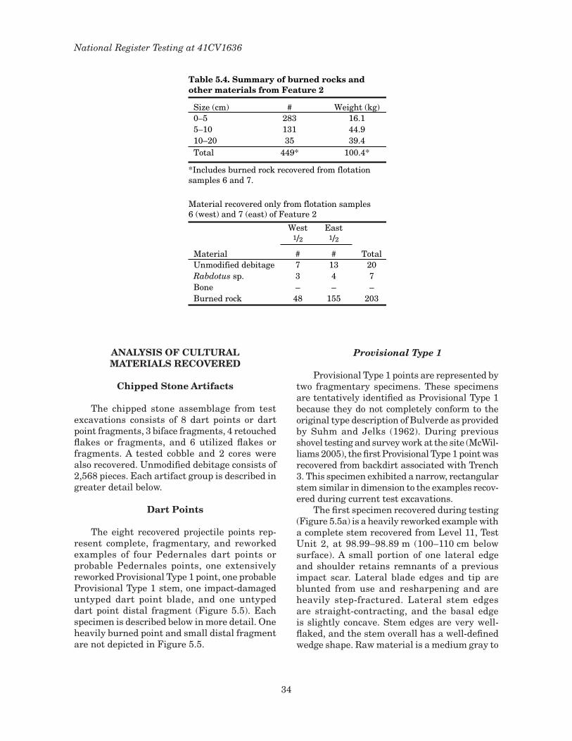
34
National Register Testing at 41CV1636
Table 5.4. Summary of burned rocks andother materials from Feature 2
Size (cm) # Weight (kg)0–5 283 16.15–10 131 44.910–20 35 39.4Total 449* 100.4*
*Includes burned rock recovered from flotationsamples 6 and 7.
Material recovered only from flotation samples6 (west) and 7 (east) of Feature 2
West East1/2 1/2
Material # # TotalUnmodified debitage 7 13 20Rabdotus sp. 3 4 7Bone – – –Burned rock 48 155 203
analysIs oF cultural matErIals rEcovErEd
chipped stone artifacts
The chipped stone assemblage from test excavations consists of 8 dart points or dart point fragments, 3 biface fragments, 4 retouched flakes or fragments, and 6 utilized flakes or fragments. A tested cobble and 2 cores were also recovered. Unmodified debitage consists of 2,568 pieces. Each artifact group is described in greater detail below.
dart Points
The eight recovered projectile points rep-resent complete, fragmentary, and reworked examples of four Pedernales dart points or probable Pedernales points, one extensively reworked Provisional Type � point, one probable Provisional Type � stem, one impact-damaged untyped dart point blade, and one untyped dart point distal fragment (Figure 5.5). Each specimen is described below in more detail. One heavily burned point and small distal fragment are not depicted in Figure 5.5.
Provisional Type 1
Provisional Type � points are represented by two fragmentary specimens. These specimens are tentatively identified as Provisional Type � because they do not completely conform to the original type description of Bulverde as provided by Suhm and Jelks (�962). During previous shovel testing and survey work at the site (McWil-liams 2005), the first Provisional Type � point was recovered from backdirt associated with Trench 3. This specimen exhibited a narrow, rectangular stem similar in dimension to the examples recov-ered during current test excavations.
The first specimen recovered during testing (Figure 5.5a) is a heavily reworked example with a complete stem recovered from Level ��, Test Unit 2, at 98.99–98.89 m (�00–��0 cm below surface). A small portion of one lateral edge and shoulder retains remnants of a previous impact scar. Lateral blade edges and tip are blunted from use and resharpening and are heavily step-fractured. Lateral stem edges are straight-contracting, and the basal edge is slightly concave. Stem edges are very well-flaked, and the stem overall has a well-defined wedge shape. Raw material is a medium gray to

35
Chapter 5: Results of Investigations
centimeters
0 1 2
a
b
c
d
ef
g
hi
Figure 5.5. Dart points and bifaces. (a, b) Provisional Type I; (c–e) Pedernales; (f) untyped blade fragment with impact fracture, (g) finished knife fragment; (h–i) middle stage distal biface fragments.
white mottled fine-grained chert. Dimensions for this specimen are: maximum length 32.45 mm; stem length �8.72 mm; stem thickness 6.94 mm; juncture width �6.09 mm; basal width �3.63; basal concavity depth �.83 mm; weight 5.4 g.
The second Provisional Type � specimen (Figure 5.5b) is a small stem fragment recovered
from Level 7, Test Unit �, between 99.52 and 99.42 m (60–70 cm below surface). The nature of the bending fracture at the juncture suggests breakage of the point in the haft during impact. One lateral ear or stem corner has been snapped off obliquely, and one edge of the bending fracture has multiple small-step fractures. The

36
National Register Testing at 41CV1636
stem is wedge-shaped, with a slightly concave basal edge. Raw material is a fine-grained medium gray chert with no flecking. Stem width is �5.84 mm, and stem thickness is 6.07 mm.
The single Provisional Type � point recov-ered during initial site survey and the two later examples recovered during the current NRHP excavations at 4�CV�636 very closely conform to the morphology of Provisional Type � points found at Fort Hood (Kleinbach et al. �999:338–344). All three have narrow, rectangular stems virtually identical to recovered specimens from dated contexts at 4�CV�235 located on Fort Hood (Kleinbach et al. �999). Stem and base measure-ments of specimens from 4�CV�636 fall within the range of variability of �� specimens recovered from 4�CV�235 (Kleinbach and Boyd �999:335). Other similar points have been recovered from the Youngsport (Shafer �963), Evoe Terrace, and Landslide sites (Sorrow et al. �967). These points also show some morphological affinities to such point types as Carrollton, Nolan, or Travis but are distinct in stem morphology from these types.
Pedernales
A series of four incomplete and relatively complete Pedernales points were recovered dur-ing excavations from proveniences stratigraphi-cally above the Provisional Type � specimens. Combined with three previously recovered Pedernales points during shovel testing and survey work at 4�CV�636, the total number of points of this type from the site is 7. Only those recovered during the current NRHP excavations are discussed below.
Two relatively complete Pedernales points were recovered from Test Unit 2, Levels 6 and �0. The first specimen (Figure 5.5c) was obtained from Level 6 between 99.49 and 99.39 m (50–60 cm below surface). It is relatively complete, with distal crushing and step/hinge fractures at the tip due to impact. One slight and one prominent shoulder are present. Lateral blade edges are slightly convex and exhibit uniform bifacial flaking. Resharpening is only evident approximately � cm back from the tip on each lateral edge and gives the tip area a beveled ap-pearance. Stem edges are straight and parallel, and the basal edge is concave. One ear of the base has a postdepositional break. Raw material is a fine-grained, moderately patinated, medium gray chert with two white chalky inclusions
similar to cortex, one near the tip and one along a blade edge. This dart point is similar to Ped-ernales Variety 3 (Goode 2002:55–56) except the stem may be bit wider. It is unclear whether this material is represented in the unmodified deb-itage. Dimensions are: length 72.75 mm; blade length 52.75 mm; blade width 27.30 mm; blade thickness 8.73 mm; stem length 20.00 mm; stem thickness 8.7� mm; juncture width 2�.52 mm; basal width 20.35 mm; basal thickness 4.79 mm; weight 20.6 g.
The second relatively complete specimen from Test Unit 2 (Figure 5.5d) was recovered from Level �0 between 99.09 and 98.99 m (90–�00 cm below surface). The tip of the blade is missing due to a postdepositional break, and one basal ear is missing and may have broken during use. The lateral blade edges are straight but have been reworked and are alternately bev-eled to the left, yielding a trapezoidal cross sec-tion to the blade. Stem edges are slightly convex, with a relatively deep basal concavity created by removal of a single flake from one surface. Stem edges are also ground smooth, and shoulders are present but not sharp. Raw material is chert. One side of the point is a fine-grained, medium gray chert and the other side grades into a light gray coarse chert that tends to yield step fractures. Thin banding is present throughout, and there is a slight patination on both faces. Unmodified debitage comparable to this mate-rial was not observed during analysis. This dart point is similar in form to Pedernales Variety 3 (Goode 2002:55–56) and is beveled similarly to a specimen recovered from Backhoe Trench 3 during the initial survey. Dimensions are: length 58.09 mm; blade length 42.48 mm; blade width 20.82 mm; blade thickness 9.20 mm; stem length �5.6� mm; stem thickness 6.03 mm; juncture width �8.50 mm; basal width �8.42 mm; basal thickness 3.4� mm; weight �3.3 g.
Two heavily burned Pedernales points that also resemble Pedernales Variety 3 from the An-thon site were recovered from Test Unit �. The first was recovered from Level 5 between 99.72 and 99.62 m (40–50 cm below surface). Compris-ing two fragments, this base/stem section has been significantly damaged by thermal fracture and potlid scars on both surfaces. Remaining stem edges are straight and slightly contract-ing. A single flake from each surface of the basal edge thinned the base and produced the concav-ity. One basal ear is pronounced and slightly

37
Chapter 5: Results of Investigations
inwardly curved, and the other is missing, prob-ably due to impact of the basal edge against the foreshaft during use. Measurements are: stem length 22.40 mm; juncture width 20.3� mm; basal width �7.73 mm. Because the fragments are heavily burned, the raw material could not be assigned to any known Fort Hood chert types or other known central Texas chert types.
The second burned specimen (Figure 5.5e) was recovered from Level 6 between 99.62 and 99.52 m (50–60 cm below surface). Although the stem is complete, both surfaces of the blade have multiple overlapping potlid scars that have re-moved much of the original flake surfaces. Stem edges are straight and slightly expanding with a concave basal edge. The basal concavity was created by multiple small flake removals on one face and one larger flake removal on the opposing face. One shoulder is present but is very slight. Measurements for this point fragment are: stem length 20.54 mm; stem width �8.06 mm; stem thickness 7.84 mm; basal concavity depth 2.43 mm. Burning precludes the formal identifi-cation of the chert type for this artifact.
In addition to these Pedernales specimens recovered during the current NRHP eligibility testing, initial site survey (McWilliams 2005) yielded three other Pedernales points. Two were recovered from general fill from Backhoe Trench 3, and one was recovered from a shovel test between 40 and 60 cm below surface. Both specimens from Backhoe Trench 3 are complete, heavily patinated, and have been bifacially reworked on the distal end. These points are similar in morphology to Pedernales Variety � points from the Anthon site (Goode 2002:5�–52). The point from the shovel test is also complete, but much thinner in cross section, has been resharpened distally by alter-nate beveling, and was manufactured of a light gray chert identified as Chert Type � for this study (see Raw Material Types below). In morphology, this point is closely similar to Pedernales Variety 3 (Goode 2002:55–56).
With the exception of two Pedernales points similar to Variety � (Goode 2002:5�–52), the points all have relatively narrow stems with essentially straight edges and basal concavities. Complete specimens from 4�CV�636 are lanceo-late rather than triangular, with straight stems, which follows the general trend of Pedernales points in collections from Fort Hood (Callister et al. �994:308–309). A similar trend in Pedernales point morphology was documented at 4�MM340
on the Little River in Milam County (Tomka et al. 2003).
Untypeable Dart Points
Two projectile point fragments were re-covered that could not be assigned to a known projectile point type. These fragments are as-signed to a general projectile point category on the basis of technology and fracture patterns, suggesting that they represent fragments of these artifacts.
The first specimen is a small distal frag-ment recovered from Test Unit �, Level 6, between 99.62 and 99.52 m (50–60 cm below surface). The piece has a diamond-shaped cross section and has been pressure flaked along the lateral edges and exhibits a bending fracture. Cross-section shape suggests it may be a dis-tal fragment of a beveled or resharpened dart point or biface.
The second specimen (Figure 5.5f) is much of the blade portion refit from two fragments recov-ered from Test Unit 2, Level 2, between 99.89 and 99.79 m (�0–20 cm below surface). The fracture that separates the refit blade portion into two pieces is possibly postdepositional in origin. The refit blade exhibits three fractures associated with distal impact. The first fracture is a large macrobreak on one face of the point associated with crushing and collapse of the tip. The second is a lateral macrofracture that removed much of one lateral edge. This fracture type is not associ-ated with removal of burin spalls. The third is a transverse break that snapped the blade from the stem portion. The remaining intact portion of one lateral edge is straight. Although the blade frag-ments are moderately patinated, a slight luster and blushes of pink on both surfaces suggest that the chert was heat treated prior to manufacture. Due to patination, it is not possible to assign this material to a known Fort Hood or Edwards Plateau chert type. Comparison of overall blade characteristics of this fragment with the projec-tile point sample suggest it may be a Pedernales blade fragment.
Bifaces
There are three fragmentary nonprojectile point bifaces recovered at 4�CV�636 (Figure 5.5g, h, and i). Two are distal fragments, and one is a sizable proximo-medial fragment. The distal

38
National Register Testing at 41CV1636
fragments can be considered as Stage II preform manufacturing failures (c.f. Frison and Bradley �980:33), while the proximo-medial fragment may be a knife or very late-stage biface fragment. All are manufactured from chert and each is described separately below.
The first biface fragment is a large proximo-medial portion of a very late stage rectangular knife or Stage III preform with a distal bending fracture. This fragment was recovered from the north wall of Backhoe Trench 3 at 99.40 m. Lat-eral blade edges are straight to slightly convex and the basal edge is slightly convex, but there are defined corners between the base and lateral edges. The piece has been shaped by well-execut-ed softhammer bifacial thinning and has a thin lenticular cross section. There is some minimal pressure flaking along the lateral edges and slight but noticeable bevels along the right edge of both faces. There are no traces of wear suggesting use or hafting, but there are patches of abrasion along the lateral edges characteristic of edge-grinding during platform preparation. Edge grinding may be associated with hafting. Some of the expand-ing flake scars on both surfaces are associated with quite small contact areas, suggesting that a percussor with a small contact area (possibly a punch) may have been used during final thinning and shaping. The raw material is a fine-grained, mottled light gray and medium gray chert with slight patina development. Scattered small white flecks or inclusions are visible in the chert, and the chert is similar to chert type � described below. The maximum length is 73.94 mm, me-dial width 45.80 mm, medial thickness 8.23 mm, basal width 32.59 mm, basal thickness 6.22 mm, and fragment weight 38.7 g.
This biface is similar in shape and technol-ogy to lanceolate bifaces commonly in association with Pedernales and other Late Archaic dart point styles. Weir illustrates identical bifacial knife forms associated with his Round Rock phase (Weir �976:60). The fragment from 4�CV�636 is also similar to the large Kinney biface preforms found in association with Late Archaic deposits containing Pedernales points at the Anthon site (4�UV60) (Goode 2002:40–50).
A distal fragment of an unfinished Stage II biface preform was recovered from Test Unit 3, Level 5, between 99.74 and 99.64 m (40–50 cm below surface). The biface broke transversely along a fracture during flaking. One lateral edge is more sinuous and less refined in shape than
the opposing edge. A mix of both hardhammer and softhammer percussion is evident along the lateral edges and faces, and the piece has a biconvex cross section. Pressure flaking is not present, although the right edge and face of one side has seen more softhammer flaking than the opposing edge and faces. Some grinding and slight smoothing associated with platform preparation is present along one lateral edge. The chert is an off-white or cream color with a light luster and may have been heat treated but is not identified as one of the seven chert types discussed below. Maximum thickness of this frag-ment is ��.90 mm.
A second distal portion of a large Stage II bifacial preform was found in Test Unit �, Level 6, between 99.62 and 99.52 m (50–60 cm below surface). This particular fragment is broken in a transverse oblique fracture. The fragment has a biconvex cross section. Both lateral edges are sinuous and reflect flaking by a mix of hardham-mer and softhammer percussion. Some grinding and slight smoothing associated with platform preparation during manufacture is present, but there is no indication of tool use. Raw material is a medium gray chert with light gray mottling that may be a developing patina. It is tentatively identified as chert type �. Maximum thickness of this fragment is ��.9� mm.
The width of each of these fragments is comparable to the more finished biface frag-ment recovered from the north wall of Trench 3 and may be early-stage fragments of similar lanceolate bifaces. The absence of earlier-stage preforms and fragments suggests that biface tool manufacture began with mid-stage preforms in which initial stages had been initiated elsewhere. The scarcity of cortex in the unmodified debitage supports this interpretation.
The complete absence of earlier stage bifaces or fragments is telling regarding probable tool kit composition of individuals and groups coming to the 4�CV�636 locality. It strongly supports an inference that lithic procurement activities were not an important aspect of activities conducted onsite and that individuals were equipped with late-stage bifacial preforms as part of their per-sonal gear.
Edge-modified Flakes
Two categories of edge-modified flake tools were recovered during excavations: utilized

39
Chapter 5: Results of Investigations
flakes and retouched flakes. Utilized flake tools are unretouched flakes or fragments that were selected for and used as tools without deliberate modification and are identified by the presence of microscopic or mac-roscopic use-wear traces. Retouched flakes have at least a portion of one edge deliberately modified by retouch of some type. Six utilized and four retouched flakes and fragments were recovered during test excavations at 4�CV�636. Most of these implements are small, like much of the unmodi-fied flake debitage, which hints that the manufacture of these expedient artifacts was based on selection of suitable flakes and fragments from debitage produced at the site dur-ing manufacture of other formal implements. Dimensions of edge-modified flakes recovered during test excavations are provided in Table 5.5. Figure 5.6 (a–g) shows representative examples of utilized and retouched flake tools recovered from 4�CV�636.
Table 5.5. Dimensions of edge-modified flakes recoveredfrom 41CV1636
Length Width Thickness WeightLot # Type (mm) (mm) (mm) (g)14-2* Utilized 39.03 – 3.58 –14-3* Utilized – 24.21 6.86 –41-1* Utilized – – 4.94 –42-1* Utilized – – 6.54 –43-1 Utilized 54.29 37.40 21.82 32.447-1 Utilized 38.49 18.67 4.77 3.014-1* Retouched – 32.10 7.69 –14-4* Retouched – 24.79 5.01 –16-1* Retouched – 35.28 15.45 –43-2* Retouched – – 9.93 –
*Indicates a fragmentary specimen.
centimeters
0 1 2
b cd
eg
�
f
Figure 5.6. Utilized flakes and retouched tools. (a–d) utilized flakes; (e–g) retouched tool fragments.
Utilized Flakes
Two flake fragments with traces of use wear were recovered from Test Unit �, Level 8, between 99.42 and 99.32 m (70–80 cm below surface). The first artifact (Figure 5.6a), a proximal fragment

40
National Register Testing at 41CV1636
of white, fine-grained chert, has pronounced edge rounding and small (<� mm) unifacial microscars with step terminations along one lateral edge remnant. The second specimen (Figure 5.6b) is a lateral flake fragment of mottled light gray and medium gray chert exhibiting primarily unifacial small microscars with feather and step terminations.
Material recovered from Test Unit 3 in-cluded four utilized flake tools, one each from Levels 6–9. Wear traces for each tool described below indicate that they were used in scraping materials of varying hardness. The specimen recovered from Level 6 (Figure 5.6c) was re-trieved from a flotation sample taken from the west half of Feature � (99.64–99.55 m). This tool is a complete softhammer bifacial thin-ning flake having small unifacial microscars (<� mm) with overlapping step and feather terminations, edge-rounding, and light polish present along one complete edge and the distal portion of the other edge.
The second example is from Level 7 between 99.54 and 99.44 m (60–70 cm below surface). It is a small, wedge-shaped flake segment re-taining a portion of a lateral edge that has a concavity created by unifacial scars (<� mm in size) with feather terminations.
A distal flake fragment (Figure 5.6d) was re-covered from Level 8 between 99.44 and 99.34 m (70–80 cm below surface). This particular tool has similar unifacial wear traces along one lat-eral edge. The chert is heavily patinated white in color and could not be assigned to a known chert type.
The final tool recovered from Level 9 between 99.34 and 99.24 m (80–90 cm below surface) is an angular fragment of grayish chert with chalcedony-like veined inclusions and a light white patina. Microscopic wear traces consist of unifacial scars (<� mm) along one end with overlapping step and feather terminations and slight edge rounding.
Utilized flake tool wear characterized by small unifacial scars with step and feather terminations indicate use as scraping tools on a variety of materials. Before the debitage was analyzed, all debris was examined for edge-modified tools. It is interesting that only scrap-ing is represented, suggesting that tool functions may have been limited to a few specific tasks, perhaps related to repair and maintenance of hunting equipment and other gear.
Unifaces
Retouched flakes were recovered from Test Unit � and Test Unit 3 in similar contexts as the utilized flakes discussed above. Three unifacially retouched flakes are from Test Unit �, and one is from Test Unit 3.
Retouched implements from Test Unit � were recovered from Levels 8 and �0. There are two from Level 8 between 99.42 and 99.32 m (70–80 cm below surface). One is a distal flake fragment (Figure 5.6e) that has been retouched along the distal edge, resembling the distal end of a small convex end scraper. The fracture surface of this fragment exhibits a negative bulb of percussion, which may indicate that the implement had been deliberately truncated, perhaps to create a new functional edge. Use wear on the edge consists of small microscars with step and feather terminations and light edge rounding. The second implement from this same context has similar use wear traces but is a small proximal flake fragment retouched along one edge. The chert material of both tools is heavily patinated. A third implement (Figure 5.6f) from Test Unit �, Level �0, between 99.22 and 99.�2 m (90–�00 cm below surface) is a flake fragment of medium to dark gray fine-grained chert with remnants of thin chalky cortex. Ir-regular retouch is present along one edge, and use wear consists of a mix of unifacial feather, step, and hinge-terminated microscars.
The single specimen (Figure 5.6g) from Test Unit 3 is a small edge fragment of a retouched flake that retains a portion of the modified edge. This tool was recovered from Level 9 between 99.24 and 99.34 m (80–90 cm below surface). Wear traces consist of continuous overlapping step-terminated microscars and moderate edge blunting but no polish. The chert material is fine-grained but pati-nated to almost a solid white color.
As with utilized flakes recovered at 4�CV�636, the small number of unifacially retouched flakes and fragments indicate that activities or tasks requiring the use of scraping implements were conducted. The importance of scraping tasks or tools at the site cannot be fully determined based on the limited data recovered. It may be significant that no edge-modified tools were identified that exhibited use wear traces attributable to cutting or other tasks. The pre-ponderance of tools and tool fragments with scraping wear may coincide with the abundance
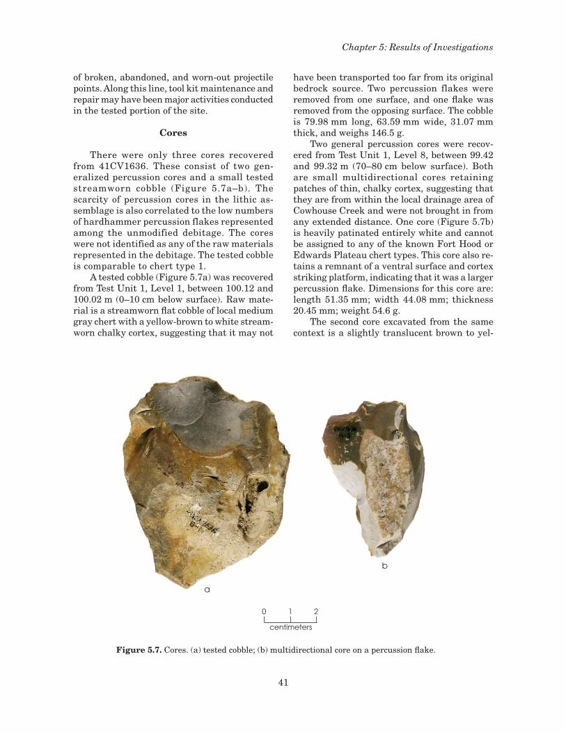
4�
Chapter 5: Results of Investigations
of broken, abandoned, and worn-out projectile points. Along this line, tool kit maintenance and repair may have been major activities conducted in the tested portion of the site.
cores
There were only three cores recovered from 4�CV�636. These consist of two gen-eralized percussion cores and a small tested streamworn cobble (Figure 5.7a–b). The scarcity of percussion cores in the lithic as-semblage is also correlated to the low numbers of hardhammer percussion flakes represented among the unmodified debitage. The cores were not identified as any of the raw materials represented in the debitage. The tested cobble is comparable to chert type �.
A tested cobble (Figure 5.7a) was recovered from Test Unit �, Level �, between �00.�2 and �00.02 m (0–�0 cm below surface). Raw mate-rial is a streamworn flat cobble of local medium gray chert with a yellow-brown to white stream-worn chalky cortex, suggesting that it may not
have been transported too far from its original bedrock source. Two percussion flakes were removed from one surface, and one flake was removed from the opposing surface. The cobble is 79.98 mm long, 63.59 mm wide, 3�.07 mm thick, and weighs �46.5 g.
Two general percussion cores were recov-ered from Test Unit �, Level 8, between 99.42 and 99.32 m (70–80 cm below surface). Both are small multidirectional cores retaining patches of thin, chalky cortex, suggesting that they are from within the local drainage area of Cowhouse Creek and were not brought in from any extended distance. One core (Figure 5.7b) is heavily patinated entirely white and cannot be assigned to any of the known Fort Hood or Edwards Plateau chert types. This core also re-tains a remnant of a ventral surface and cortex striking platform, indicating that it was a larger percussion flake. Dimensions for this core are: length 5�.35 mm; width 44.08 mm; thickness 20.45 mm; weight 54.6 g.
The second core excavated from the same context is a slightly translucent brown to yel-
centimeters
0 1 2
a
b
Figure 5.7. Cores. (a) tested cobble; (b) multidirectional core on a percussion flake.

42
National Register Testing at 41CV1636
low-brown banded chert with patches of white patina. This core has cortex remnants on two surfaces, indicating that it was initially a small chert cobble, probably procured from the local gravel bedload of Cowhouse Creek. This core is 58.92 mm long; 33.02 mm wide; 23.�9 mm thick; and weighs 47.0 g.
refit Flakes
During the excavation of Test Unit �, two small flakes (Figure 5.8) of light gray, slightly patinated chert (probably chert type �) were recovered from Level �2 between 99.02 and 98.92 m (��0–�20 cm below surface). There are no other indications of the presence of a core technique in the lithic assemblage. The small blade-like flake has no cortex and has a central ridge and two longitudinal flake scars. A single faceted striking platform with light dorsal edge grinding and a pronounced lip suggest that this flake was removed from a prepared platform by softhammer percussion. The corresponding flake that refits to the blade has a slightly crushed platform and a diffuse bulb of percussion. Given the absence of blade cores or other blade-related debitage, these refits were probably produced during biface manufacture. Dimensions of the blade-like flake are: length 27.3� mm; width 8.72 mm; thickness 2.38 mm; weight 0.5 g. Dimensions of the larger flake are: length 34.28 mm; width 27.32 mm; thickness 3.77 mm; weight 2.6 g.
unmodIFIEd dEBItagE
Unmodified debitage represents 99 percent (n = 2,544) of all recovered lithic artifacts, giv-ing a ratio of flakes to tools/cores of 97:�. Test Units �, 2, and 3 had the greatest abundance and density of unmodified debitage (96 percent of all debitage). Coupled with the presence of only two small cores and one tested cobble, this finding implies that tool repair or bifacial reduction were emphasized over production of flakes from generalized percussion cores. The highly fragmentary and resharpened character of recovered dart points also strongly suggests a lithic assemblage produced by an emphasis on tasks associated with tool maintenance and less emphasis on raw material procurement. The presence of a proximo-medial bifacial knife fragment and two distal fragments of Stage II bifaces also supports a lithic technology geared toward biface manufacture and bifacial tool maintenance. The discussion below begins with a brief description of identified raw materials and interpretations of the regional potential for lithic raw materials, followed by interpretations of debitage patterns.
raw material types
A number of caveats should be mentioned regarding the identification of various chert types from sites along Cowhouse Creek beyond the range of known chert types on Fort Hood. Previous studies have reported that the iden-tification of chert types from bedload gravels is particularly problematic given their resem-blance to other chert types (Ellis et al. �995:58; Boyd �999:379). Ellis et al. (�995:58) indicate that darker gray hues of Cowhouse Dark Gray (Type �9) can be mistaken for examples of Owl Creek Black (Type �7), even though they are not geologically or geographically related. Smaller pieces of Cowhouse Mottled with Flecks (Type 22) can also be misidentified as fragments of Heiner Lake Tan (Type 6). In a series of blind chert type identification tests by several different analysts, the consensus regarding bedload cherts was that they are problematic and may not represent real chert types (Boyd �999:379). A significant prob-lem is that there are no criteria for describing the amount of variability within bedload cherts resulting from weathering or saturation while the nodule is part of the stream’s clast material.
centimeters
0 1 2
Figure 5.8. Refit small blade-like flake and larger flake.

43
Chapter 5: Results of Investigations
A phenomenon observed on examples of Types �8–28 is that there is a two-tone differentiation between a lighter outer zone and a darker inner zone of material. This study further concluded that Cowhouse Two Tone (Type �8), Cowhouse Dark Gray (Type �9), Cowhouse Mottled with Flecks (Type 22), and Cowhouse Banded and Mottled (Type 23) are not valid chert types and should be discarded from the Fort Hood chert type nomenclature.
During the debitage analysis, an effort was made to compare chert types from 4�CV�636 to known chert types on Fort Hood (see Table 3.�). An abundance of small flake sizes and moderate to heavy patination on a majority of the sample defeated efforts to identify any Fort Hood chert types. Consequently, a generalized chert typology was developed. The chert types identified are broadly comparable in quality and appearance to the various Edwards Group formation cherts described and illustrated by Banks (�990:�23–�25).
Seven chert types were identified but could only be broadly compared to known Fort Hood chert types. These consist of three major types and five secondary types. Isolated examples of unique cherts were grouped within an indeter-minate chert category.
Chert type � includes all flakes of a light to dark gray, with occasional to common small white flecks of coarser material. Scattered small bluish-white inclusions are present in some larger pieces. Munsell color variability for this category is light bluish-gray to bluish-gray (Gley 2 7/5PB to Gley 2 5/�0B). Patinated examples include lighter hues, and a few flakes were bluish black (Gley 2 2.5/FB). The raw material has apparent good to excellent con-choidal fracture and evidence of deliberate heat treatment was not observed. Burned examples did not exhibit signs of reddening but did show evidence of crazing, spalling, and potlid scars. The flecking observed as a characteristic of this material is also a common characteristic of several Fort Hood chert types. The closest comparable Fort Hood chert type to Chert Type � is East Range Flecked, which has a limited geographic occurrence near the northern end of Lake Belton. However, chert type � lacks the abundance of flecking observed in East Range Flecked.
Chert type 2 is comprised of medium to heavily patinated flakes of fine-grained opaque
and translucent cherts. This group probably includes several area chert types. Color varies on heated examples to include subtle hues of pink, red, and occasionally pinkish-gray. White or off-white flecking was not present in this material. Conchoidal fracture varies from good to excellent, especially for more translucent examples. Mottling was common in many specimens.
Chert type 3 included pieces with white/off-white coloring and slight banding. Munsell colors included Gley � 8/N and �0YR 5/8. Conchoidal fracture was excellent, and the material was moderately patinated. Heat treatment was not observed. This was the only banded chert observed in the unmodified debitage from 4�CV�636.
Chert type 4 may represent less patinated or unpatinated specimens of chert type 2 described above, with translucent to opaque examples common. Varying hues of �0YR and 5YR are common. Chert types 2 and 4 are considered to represent undifferentiated cherts of the Ed-wards Group. Conchoidal fracture was good to excellent, and some specimens appear to have been heat treated.
Chert type 5 consists of a fine-grained opaque chert with a chalky off-white to grayish cortex. Color varies from a very pale brown (�0YR 8/2) to yellow (�0YR 7/4), and heated examples exhibit varying shades or light to medium red or orange brown hues of color. Lightly heated flakes are slightly pink. Conchoidal fracture is good to ex-cellent. Some mottling of colors is observed, with inclusions of more translucent brown material in some larger flakes. No flecking is present.
Chert type 6 is a translucent to cloudy white fine-grained material with reddish staining and light patination. The translucency and reddish to reddish orange staining are very similar to that described for Seven Mile Novaculite. Although represented by only two pieces of unmodified debitage, this material is a possibility. Seven Mile Novaculite occurs as a source material to the southwest of Copperas Cove, Texas.
Chert type 7 represents single flakes of chert types that could not be placed within one of the above larger groupings. Little can be said regarding reduction or manufacture techniques associated with these materials. Color is variable.
There appears to be little room for direct comparison between chert types from 4�CV�636 and those known to occur along Cowhouse Creek

44
National Register Testing at 41CV1636
as it flows through Fort Hood. Reasons would include differences in local geology and stream bedload characteristics. Prehistoric raw mate-rial selection choices based on locally available chert types also contributed to the raw material differences between those types from 4�CV�636 and Fort Hood.
raw material catchment
Within a 20-km radius of 4�CV�636 on Cowhouse Creek, several drainages and divides provide potential sources of lithic material (Fig-ure 5.9). From southwest to northeast, these include portions of the Lampasas River/Bennett Creek confluence, House Creek to its confluence with Cowhouse Creek, Cowhouse Creek, Plum Creek and its confluence with the Leon River, and a stretch of the Leon River from just east of Hamilton to Gatesville. There are three poten-tial zones of procurement for raw material: the stream gravels and Holocene and Quaternary gravels and terraces, bedrock exposures along the streams at the valley walls, and any avail-able exposures along the upland divides. Along Cowhouse Creek, upstream and downstream from 4�CV�636, there are �3 mapped Quater-nary terrace deposits. Three larger remnants of Quaternary terraces are mapped along portions of the Leon River within 20 km of the site.
Stream valley walls are primarily eroded into the Lower Cretaceous Glen Rose Formation, and the upland divides are predominantly the Walnut Formation. Neither of these formations are particularly abundant with chert, and in fact may be considered chert free. Edwards limestone exposures occur to the west and southwest of 4�CV�636 between �0 and 20 km. Edwards limestone comprises portions of the upland di-vide between the Lampasas River and Cowhouse Creek. Duck Creek limestone and Kiamichi Clay outcrop 20 km northeast of the site, east of the Leon River, but they are also poor in cherts.
The best sources of bedrock raw material are to the south and west of 4�CV�636. To the north and east of the site, potential raw material sources consist of stream gravels and Quaternary terrace remnants along the Leon River. A thin zone of Edwards Formation rocks east of the Leon River and another area southeast at the edge of the 20-km catchment could also have been a source of suitable bedrock chert. Certainly to the north and east, suitable
sources of raw material become more scarce until one enters the Bosque and Brazos River drainages near Waco with abundant Quaternary terrace deposits and remnant Quaternary High Gravels. These drainages also are potential sources of more Edwards Formation bedrock cherts. The channel of Cowhouse Creek itself would have been a suitable chert procurement source, farther to the southeast as it flows into the Fort Hood area. Here the creek flows through an area that has potentially more sources of bedrock chert to be contributed to the creek bedload. In the vicinity of 4�CV�636, Cowhouse Creek was a poor source of suitable cherts for manufacturing flaked stone tools, particularly bifacial knives and projectile points. The scarcity of cortex, specifically streamworn and abraded types, in the lithic assemblage indicates that procurement from any adjacent gravel lithic sources was very limited. Low cortex numbers, limited evidence of percussion core flaking, and an absence of bifaces in early stages of manufacture suggest that raw material procurement activities may have been of minimal importance as a task at 4�CV�636. Considering the scarcity of suitable material in the immediate vicinity (between 5 and �0 km of 4�CV�636), the site may be viewed as in a transition zone between raw material source areas to the northeast, southwest, and southeast.
unmodified debitage Patterns
Characteristic of most sites in central Texas, the most abundant artifact category recovered from 4�CV�636 was unmodified lithic debitage. Analysis of unmodified debitage focused on identification of raw materials, size grading, and determination of flake types present within the assemblage. Flake aggregate analysis or size grading shifts the focus of analysis from individual flakes to flake assemblages. This ap-proach is ideally suited to assemblages with large numbers of flakes and/or assemblages dominated by small sizes of unmodified debris not suit-able for detailed and time-consuming attribute analyses. One assumption made in this study is that specific flake types can be identified that are indicative of distinct flaking techniques.
Although it is acknowledged that similar flake types can be produced by a variety of techniques, it was decided that the debitage

45
Chapter 5: Results of Investigations
mile
0 2 4 8
kilometer
0 2 4 8
Kwa
Kwa
Kwa
Ked
Ked
Kgr
Kgr
Kgr
Kgr
Kked
Kked
KwaLam
pa
sas
River
House
Creek
Cow
houseCreek
Leon
River
Plum
Creek
Kdfdc
L E G E N D
Quaternary Terrace Edwards Limestone
Kiamichi Clay & Edwards Limestone
Walnut Formation
Glen Rose Formation
Denton Clay
P A I / 0 6 / B W
41CV1636
Ked
Kked
Kwa
Kgr
Kdfdc
Figure 5.9. The 20-km radius around 4�CV�636 shows potential sources of lithic raw material.

46
National Register Testing at 41CV1636
from 4�CV�636 was amenable to identification of specific flake types. Flake type categories were defined on the basis of previous experience in lithic analysis, a clear perception of fracture mechanics, and understanding in lithic technological studies of what attributes typically are “understood” to define particular flake types. Flake types selected for this analysis are described earlier in this report. Much like the identification of specific projectile point styles, flake types are identified based on assessments of multiple lines of morphological, technological, size grade data and qualitative interpretations of combinations of these lines of inquiry. It is acknowledged that there is undoubtedly some technological overlap between some flake categories identified in this study (for instance between notching flakes and punch flakes) but that technological characteristics between flake types are sufficiently distinct to allow their identification in the archeological assemblage. During the initial sorts of unmodified debitage from 4�CV�636, observations were made that deemed the above analytical approach as appropriate. First was the virtual absence of debris that is technologically comparable to generalized percussion core or hardhammer flake production. Second, a high proportion of broken debris and a preponderance of flakes comparable to biface thinning suggested a debitage assemblage representing a restricted technological origin having little mixing of different reduction techniques. Third, the unmodified debitage was overwhelmingly represented by small and very small flake sizes characteristic of late-stage reduction and/or small tool manufacture. The predominance of projectile points and biface fragments over utilized flakes and unifaces also suggested a lithic assemblage produced by a narrow range of flaking techniques. Certainly, flaked tool manufacture and general percussion core reduction were not being conducted in any great abundance within the tested portion of the site. It is argued that the character of the unmodified debitage from 4�CV�636 is suitable for the identification of particular types of flakes because those types of knapping techniques were applied in sufficient abundance that they can be recognized in the archeological record. This is a direct argument for the existence of stages in lithic manufacture (Bradbury and Carr �999:�06).
To further interpret the unmodified debitage assemblage from 4�CV�636, the assemblage is briefly compared to other size-graded experi-mental debitage data sets. The experimental sets all have a significant biface component for comparison and are briefly discussed below.
The first comparative debitage sample was produced as part of a replication experiment to produce a Clovis point and to quantify differences between manufacture stages (Henry et al. �976). The experiment produced �,202 flakes. The ex-periments were conducted by Bruce Bradley.
The second comparative sample of flake de-bris was produced by J. B. Sollberger as part of a demonstration for members of the South Texas Archaeological Association (Gunn and Mahula �977; Gunn et al. �976). Sollberger’s demon-stration was geared to show three basic stages in the biface reduction process: cortex removal and preforming, shaping and thinning, and sharpening. The manufacture process resulted in the completion of a large, corner-notched dart point similar in shape and size to the Marcos and Marshall types. This experiment in biface reduc-tion toward dart point manufacture produced an assemblage of 522 flakes.
The third experimental flake assemblage was produced by Glenn Goode as part of the interpretive analysis for material excavated from the Bull Pen site (4�BP280) in Bastrop County (Ensor et al. �988). Goode’s replications were devoted to manufacture of �0 Pedernales points utilizing chert cobbles from the Willis and Uvalde gravels and material from Colorado River terraces (Goode �988). He perceived three manufacturing stages: initial, intermediate, and final. The experiments produced a total of 2,900 flakes.
The fourth comparative assemblage was produced by Patterson and Sollberger (�978) as part of a series of biface manufacture experi-ments designed to quantify differences between small debitage produced by different flaking techniques: pressure flaking, hard hammer-stone, soft billet, soft hammerstone, and indirect percussion. The importance of this sample for comparative purposes is significant given the inclusion of indirect percussion as part of the experimental structure. This experimental set is also important because the sample was segregated into known flake types, and direct comparisons of size distributions can be made with archeological material from 4�CV�636.

47
Chapter 5: Results of Investigations
One important aspect of each of these experimental data sets (Table 5.6) is that flakes were segregated by flake type based on the type of percussor used during the flintknapping process. This allows one to segregate size-graded debris during analysis by flake production techniques. Closer comparisons can be made between the experimental assemblages and material recovered from 4�CV�636. The size of experimental data sets is not considered to be a significant limiting factor because each segment represents a discrete and controlled behavior or set of behaviors associated with different aspects of biface and dart point manufacture.
The unmodified debitage sample included all flakes from Test Units �, 2 and 3 (excluding material from flotation samples) and totals 2,208 pieces. Material from Test Unit 4 was omitted due to small sample size. However, the raw material colors observed in the sample recov-ered from Test Unit 4 are comparable to those obtained from Test Units �, 2, and 3.
Proportions of different raw materials between test units are comparable for the most abundant chert types (Table 5.7). An examina-tion of chert types by size grade shows the pre-dominance of debris within small size classes (Table 5.8; Figure 5.�0). The sample is made up of identifiable flakes and fragments (37 per-cent), indeterminate flake fragments (missing striking platforms) (58 percent), and burned and unburned shatter (5 percent). Just over 90 percent of the debitage was confined to size classes � and 2 (92 percent, n = 2,024), indicat-ing that a large proportion of the assemblage was less than �0 mm in maximum dimension. Brief comparison with the experimental data sets demonstrates that an abundance of flakes within small size grades (typically less than �0–�5 mm in maximum dimension) characterize debris assemblages created during dart point manufacture and late-stage biface finishing activities. Proportions of similar size grade data from these experiments was 40 percent (Gunn et al. �976), 79 percent (Goode �988), and 89 per-cent (Henry et al. �976).
Evidence of cortex, deliberate heat treat-ment and burning provides information on the character of raw material in the assemblage. Cortex abundance for recovered material cor-responds to the abundance of small flake sizes, with 96 percent (n = 2,��7) of all analyzed un-modified debitage having no cortex. Cortex of
varying amounts was present on only 4 percent (n = 9� pieces). Pieces with complete dorsal cortex represent only � percent (n = 2�) of the sample, while other pieces with partial cortex represent a combined total of only 3 percent (n = 70). Cortex could be divided into several categories: abraded/weathered chalky white (n = 4), chalky white streamworn (n = 7), chalky white unweathered (n = �5), chalky stained unweathered (n = 8), thin streamworn (n = �4), and patinated cortex (n = �). Evidence of deliberate heat treating was only visible on 8 specimens, indicating that preforms or other tool blanks brought to the site were not deliberately altered. Despite the fact that there were two burned rock features at the site, the abundance of burned flakes and burned shat-ter was low. The total number of burned flakes is �4, and the total number of burned shatter pieces is 48. In total, heat treated and burned pieces represent only 3 percent of all unmodi-fied debitage.
Chert types �, 2, and 4 were the most abundant materials at 4�CV�636. Chert types � and 2 represent a combined total of 92 percent of the unmodified debitage. Type � (n = 907) is 4� percent, and type 2 (n = �,��7) is 5� percent of all debitage. Proportions of different chert types are comparable between Test Units �, 2, and 3. There does not appear to have been any concentrated reduction of material in any of the test units analyzed. These chert types provide the best glimpse of lithic-related activities that probably occurred at 4�CV�636. Acknowledging difference in sample size and the general problems of flake type identification, the proportions of different flake types between these three materials are striking in their concordance (Table 5.9). Although we cannot address the number of occupations or whether the site represents a single occupation, the uniformity in debitage patterns argues for rather uniform activities conducted over a rather short span of occupation(s).
Distribution of different flake types by size class (Table 5.�0; Figure 5.��) for unmodified debitage at 4�CV�636 reveals distinct patterns comparable to those of similar debris categories produced experimentally. Hardhammer and bi-face thinning flakes are associated with larger size classes. This trend is also observed in the experimental datasets. The upper size limits of these flake types correspond closely to the

48
National Register Testing at 41CV1636
Table 5.6. Experimental debitage data sets for comparison with 41CV1636
Henry et al. 1976 experimental Clovis data
Size GradeHard-
hammerCum.Totals
Cum.%
Soft-hammer
Cum.Totals
Cum.% Pressure
Cum.Totals
Cum.%
25 mm 17 17 2.37 29 29 3.45 – – –
19 mm 34 51 7.12 34 63 7.49 – – –
16 mm 30 81 11.31 44 107 12.72 – – –
13 mm 48 129 18.01 74 181 21.52 – – –
10 mm 105 234 32.67 123 304 36.15 – – –
4 mm 482 716 100.00 537 841 100.00 183 183
Total 716 841 183
Gunn et al. 1976 experimental projectile point manufacture data
Size Grade Phase ICum.Totals
Cum.% Phase II
Cum.Totals
Cum.% Phase III
Cum.Totals
Cum.%
>80 mm 3 3 1.52 – – – – – –
40–80 mm 23 26 13.20 – – – – – –
20–40 mm 30 56 28.43 16 16 6.72 – – –
10–20 mm 48 104 52.80 38 54 19.10 15 15 14.71
4.49–10 mm 93 197 100.00 184 238 100.00 72 87 100.00
< 4.49 mm* 351
* Material in this size range was not included in analysis by Gunn etl al. 1976.
Goode 1988 experimental Pedernales point manufacture data
Size GradeTotal
CountsCum.Totals
Cum.% Hardhammer %
Cum.% Softhammer %
Cum.%
1 (>36 mm) 40 40 1.38 2.87 2.87 5.35 5.35
2 (36–25 mm) 174 214 7.38 12.03 14.90 21.63 26.98
3 (25–17 mm) 401 615 21.21 35.24 50.14 34.88 61.86
4 (17–12 mm) 603 1218 42.00 49.86 100.00 38.14 100.00
5 (<12 mm) 1,682 2,00 100.00 (not included) (not included)
Patterson and Sollberger 1978 experiments in small debitage*
Size Grade PressureCum.
%
Hardhammer-
stoneCum.
%Softbillet
Cum.%
Softhammer-
stoneCum.
% IndirectCum.
%16–18 mm 2 1.80 5 3.40 7 4.68 2 6.67 5 10.43
14–16 mm 2 3.60 7 8.16 8 10.01 2 13.34 7 25.01
12–14 mm 4 7.20 13 17.00 8 15.34 2 20.01 4 33.34
10–12 mm 11 17.11 20 30.61 15 25.34 4 33.34 7 47.92
8–10 mm 23 37.83 29 50.34 44 54.67 7 56.67 4 56.25
6–8 mm 69 100.00 73 100.00 68 100.00 13 100.00 21 100.00
* Cumulative totals are omitted because the sample represents only a portion of a complete biface reductionsequence.

49
Chapter 5: Results of Investigations
maximum widths of Stage II biface fragments recovered from the site, suggesting that biface finishing and/or dart point manufacture began with bifacial preforms of ± 50 mm maximum width, possibly slightly larger since maximum flake size cannot exceed the width of the flaked piece. Flake type size distributions further in-dicate that both hardhammer and softhammer percussion were applied throughout the manu-facture sequence.
The size distribution of punch flakes fol-lows closely those of hardhammer and biface thinning flakes, indicating that the punch technique was applied sporadically during manufacture. The abundance of punch flakes demonstrates that it was not the primary flak-ing technique for making bifaces, but appears to have been used periodically to solve specific knapping problems or may have been associ-ated with platform or surface preparation. Of the sample of �08 identified punch flakes, six appear to have been removed as efforts to
Table 5.7. Proportion of different chert types at 41CV1636
ChertType TU 1 TU 2 TU 3 Site Total
Total % Total % Total % Total %1 292 35.35 326 46.91 289 42.07 907 41.082 463 56.05 325 46.76 329 47.89 1,117 50.593 – – 2 0.29 3 0.44 5 0.234 65 7.87 22 3.17 44 6.40 131 5.935 5 0.60 17 2.45 14 2.04 36 1.636 – – – – 2 0.29 2 0.097 1 0.12 3 0.43 6 0.87 10 0.45
826 100.00 695 100.00 687 100.00 2,208 100.00
Table 5.8. Size grade by chert type
Size Grade—in. (mm) 1 2 3 4 5 6 7 Total % Cum. %< 0.25 (<6.3) 274 277 2 33 8 1 1 596 27.00 27.000.25–0.38 (6.3–9.5) 392 517 1 46 17 1 5 979 44.34 71.340.38–0.50 (9.5–12.5) 143 185 1 32 6 – 3 370 16.76 88.100.50–0.75 (12.5–19.0) 88 118 1 12 3 – 1 223 10.09 98.190.75–1.00 (19.0–25.0) 5 18 – 6 1 – – 30 1.35 99.541.00–1.50 (25.0–37.5) 5 1 – 2 1 – – 9 0.41 99.951.50–2.00 (37.5–50.0) – 1 – – – – – 1 0.05 100.00Total 907 1,117 5 131 36 2 10 2,208 – –
% Raw Materials 41.08 50.59 0.23 5.93 1.63 0.09 0.45 100.00 100.00 –
correct specific knapping problems common in biface manufacture: remove concentrations of hinge terminations along a biface edge (n = 3), removal of thick areas (n = 2), and removal of a collapsed platform area (n = �). In general, punch flakes appear to have been produced during thinning phases of biface shaping, with the technique being applied in concert with the use of a softhammer to thin bifaces. Additional indications of biface manufacture can be found in the presence of biface edge collapse flakes associated with chert types � (n = 5), 2 (n = 9), and 4 (n = 2). It is possible that some of the biface edge collapse flakes represent knapping errors produced by indirect percussion as well. That indirect percussion would not have been an efficient method of completely flaking bifaces is supported by experimental observations of Sollberger: general awkwardness of holding the preform, extended time for manufacture as compared to direct percussion, and requirement of more extensive platform preparation (Patter-

50
National Register Testing at 41CV1636
Figure 5.10. Distribution curves for chert types and size grade.
Table 5.9. Flake type by chert type
Flake Type 1 2 3 4 5 6 7 Total %Bifacial Thinning 189 208 – 19 11 – 3 430 19.47Biface Edge Collapse 5 9 – 2 – – – 16 0.72Notching 5 16 – 1 – – 1 23 1.04Pressure 60 83 – 5 4 – – 152 6.88Punch 33 59 – 13 3 – – 108 4.89Bipolar 3 – – – – – – 3 0.14Core Platform Rejuvenation – 1 – – – – – 1 0.05Hard Hammer 25 40 – 9 1 – – 75 3.40Uniface Resharpening – 1 – – – – – 1 0.05Unburned Shatter 18 22 – 6 3 1 1 51 2.31Burned Shatter 15 18 2 10 – – 3 48 2.17Hammerstone Spall 1 – – – – – – 1 0.05Indeterminate 553 660 3 66 14 1 2 1,299 58.83Flake Total 907 1,117 5 131 36 2 10 2,208 –
% Raw Materials 41.08 50.59 0.23 5.93 1.63 0.09 0.45 100.00 100.00

5�
Chapter 5: Results of Investigations
Table 5.10. Flake type by size grade
Size Grade–in. (mm)
Flake Type < 0.
25 in
.(<
6.3)
0.25
–0.3
8(6
.3–9
.5)
0.38
–0.5
0(9
.5–1
2.5)
0.50
–0.7
5(1
2.5–
19.0
)
0.75
–1.0
0(1
9.0–
25.0
)
1.00
–1.5
0(2
5.0–
37.5
)
1.50
–2.0
0(3
7.5–
50.0
)
Total %Bifacial Thinning 45 214 95 64 11 1 – 430 19.47Biface Edge Collapse 3 8 5 – – – – 16 0.72Notching 10 13 – – – – – 23 1.04Pressure 104 47 1 – – – – 152 6.88Punch 8 57 22 21 – – – 108 4.89Bipolar 1 2 – – – – – 3 0.14Core Platform Rejuvenation – – – 1 – – – 1 0.05Hard Hammer – 10 29 23 8 4 1 75 3.40Uniface Resharpening – – – 1 – – – 1 0.05Unburned Shatter 14 26 4 5 1 1 – 51 2.31Burned Shatter 12 27 4 3 2 – – 48 2.17Hammerstone Spall – – – – 1 – – 1 0.05Indeterminate 399 575 210 105 7 3 – 1,299 58.83Flake Total 596 979 370 223 30 9 1 2,208 –
% Size Grade 27.00 44.34 16.76 10.09 1.35 0.41 0.05 – 100.00
son and Sollberger �978:�08). However, there is little published data available on the use of this technique to augment the manufacture process or on its use as an aid to resolving knapping er-rors, for which its use at 4�CV�636 is inferred. Further experimentation on the applications of indirect percussion as one of several flaking techniques in Archaic period lithic technology should be conducted.
Flake types such as pressure and notch-ing are primarily restricted to the smaller size classes � through 3 (6.3–�2.5 mm) and are presumed to be most often related to very late or final efforts of formal biface and pro-jectile point manufacture. Punch flakes from 4�CV�636 were most abundant in size class 2 (6.3–9.5 mm) but were also common in size classes 3 and 4 (9.5–�9.0 mm). Pressure, notch-ing, and punch flakes represent a combined total of �3 percent of all unmodified debitage and 3� percent of all identifiable flakes and proximal flake fragments. In comparison, hardhammer flakes represent only 3 percent of all unmodified debitage and 8 percent of all identified flakes and fragments. Patterson and
Sollberger (�978:��0) produced similar flakes in nearly identical size ranges while manufactur-ing a series of five experimental bifaces between ca. 70 and ��0 mm maximum length and ca. 30–55 mm maximum width. Size distributions for experimental pressure flakes ranged between 6 and �2 mm, and indirect percussion (punch) flakes were concentrated between 6 and 8 mm but varied in size up to �6–�8 mm. Other ex-perimental data sets produced such specialized flakes between 4 and 20 mm (Henry et al. �976; Gunn et al. �976). Although we must be careful about placing undue credence in comparisons of experimental and archeological datasets, the concordance is striking and tantalizing and tends to support the above inferences that the unmodified debitage at the site was produced largely during late-stage biface and projectile point manufacture. The paucity of other flake types such as core rejuvenation flakes, uniface resharpening flakes, and bipolar flakes, coupled with the scarcity of cores, indicates that core reduction and the manufacture of other tool types were not common activities at this portion of the site or perhaps at the site in general.

52
National Register Testing at 41CV1636
Figure 5.11. Size class distribution curves for various flake types.
nonFEaturE BurnEd rocks
Excavations at 4�CV�636 yielded varying amounts of burned rocks from nonfeature contexts. Burned rocks appear across the site, with the exception of several negative levels. A total of �78 kg of such material was removed from the four test units. Burned rocks were also observed consistently in all excavated backhoe trenches and in profiles. Weights from nonfeature proveniences ranged from less than 0.� kg to 0.7 kg.
Faunal rEmaIns
Test excavations yielded �63 bone frag-ments. Bone was not generally common, the exception being Test Unit 3, which produced 49 fragments, mostly from Levels 9–�2 (99.34–98.94 m). A flotation sample from the western
half of Feature � yielded an additional �6 small unidentifiable bone fragments. Additional flota-tion samples from Test Unit 3 yielded 3 small unidentifiable fragments from Level 7 and 79 fragments from Level 9 (99.34–99.24 m). In total, Test Unit 3 contained �46 pieces of bone. Test Unit 2 yielded up 7 fragments: 6 from Level 8 (99.29-99.�9 m) and � from Level �2 (98.89–98.79 m). Four bone fragments were recovered from manual excavations in Test Unit �: 3 from Level 8 (99.42–99.32 m) and � from Feature 2 (99.29–99.09 m). A flotation sample from Level 9 contained 2 small uniden-tifiable fragments. Test Unit 4 yielded the least amount of faunal material, with 2 fragments from Level 2 (�00.25–�00.�5 m). The majority of specimens are small, fragmentary, and gen-erally unidentifiable to order, genus, or species but appear to represent small to medium-sized mammals. Table 5.�� provides identifications

53
Chapter 5: Results of Investigations
Table 5.11. Summary of faunal remains from 41CV1636
Test Unit Lot # LevelDepth(cmbs) Elevation Specimen ID
No. ofFragments
1 14 8 70–80 99.42–99.32 Small vertebrate 3fragments
1 19 – 83–99 99;.29–99.17 Unidentifiable mammal 1(Fea. 2, W 1/2, float #6)1(NE Quad, float #5)
9 80–90 99.32–99.22 Small mammal long boneshaft fragments, burned
2
2 26 8 70–80 99.29–99.19 2 unidentifiable medium 6mammal; 4 mediummammal long bone shaftfragments
2 27 9 80–90 99.19–99.09 Unidentifiable mammal 12 30 12 110–120 98.89–98.79 Medium mammal long
bone shaft fragment(burned black 75%)
1
3 38 4 30–40 99.84–99.74 Unidentifiable mammal 13 6 50–60 99.64–99.55 Unidentifiable small 16(Fea. 1, W 1/2, float #1) vertebrate
fragments/splinters3 7 60–70 99.54–99.44 Unidentifiable vertebrate 3(SW Quad, float #2) fragments, burned3 43 9 80–90 99.34–99.24 6 small mammal long bone
shaft fragments (5weathered white); 1unidentifiable mammal
10
(weathered white); 3 smallunidentifiable mammal
3 9 80–90 99.34–99.24 2 small unidentifiable 79(SW Quad, float #4) mammal tooth fragments;
1 small mammal femoralhead; 76 mixedsplinters/shaft fragmentsof small unidentifiablemammal
3 44 10 90–100 99.24–99.14 1 small mammal long oneshaft fragment; 1 smallunidentifiable mammal
2
3 45 11 100–110 99.14–99.04 3 unidentifiable mammal 16(burned gray); 4 smallmammal long bone shaftfragments (2 burned gray);2 mammal rib shaftfragments; 7 unidentifiablemammal (unburned)
3 46 12 110–120 99.04–98.94 13 medium mammal longbone shaft fragments; 7unidentifiable mammal
20
4 50 2 10–20 100.25–100.15 Unidentifiable medium 2mammal

54
National Register Testing at 41CV1636
and provenience information of faunal material recovered from each test unit and from flotation samples. The relatively high percentage of bone fragments is probably due to natural taphonomic factors rather than human impacts such as mar-row extraction or grease production, although these activities cannot be altogether ruled out. It is interesting that no fragments or elements identifiable as bison were recovered.
mussEl shEll and RabDoTUs sP.
Mussel shell fragments were common at 4�CV�636, but due to postdepositional frag-mentation and other taphonomic factors, only umbos and hinge teeth were counted (n = �8) and collected (Table 5.�2). Scattered other frag-ments of mussel shell were observed during excavation but were highly fragmented, poorly preserved, and could not be identified to species. The recovered specimens may represent as few as 9 complete mussels or as many as �8 indi-viduals. Almost one-third of the umbos or teeth are heated and burned (n = 5; 28 percent), and this is probably a contributing factor to their fragmentary condition. Umbos or teeth were col-lected from Test Units �, 2, 3, and 4 from Levels 2, 5, 6, 8 ��, and �2 (99.62–98.92 m). Recovered specimens tended to be present in or near levels
containing relatively high artifact densities and generally absent in other levels.
Species represented are Lampsilis sp. (n = 6), Amblema plicata (n = �), and Cyrtona-ias tampicoensis (n = �). The remaining �0 specimens were too eroded or fragmentary to enable identification. All recovered specimens were probably used for subsistence, and none are modified. Each of these species is common for large and medium-sized stream systems and in a variety of substrates like sand, gravel, and mud in central Texas and adjacent regions and are not unexpected in the assemblage (Howells et al. �996). The variety of species identified also indicates that the hydrologic character of Cowhouse Creek as a perennial stream has not changed.
Rabdotus sp. snail shells appeared frequently, but only whole shells were counted (n = 3�5). Frequency of counted whole shells and observations of fragmentary specimens followed the vertical distribution of lithic artifacts and faunal remains, but it was not determined if snails were a food source at the site. The majority of Rabdotus sp. whole shells were observed in Test Unit 2 (n = �42, 45 percent). Lesser numbers of shells were observed in Test Unit � (n = 72) and Test Unit 3 (n = 97), but their presence in Test Unit �, 2, and 3 corresponds to the presence and abundance of faunal material
Table 5.12. Summary of mussel shell umbos and hinge teeth recovered from 41CV1636
Test DepthUnit Lot # Level Feature (cmbs) Elevation Species Condition #
1 11 5 40–50 99.72–99.62 Lampsilis sp. 11 12 6 50–60 99.62–99.72 Unidentified fragmentary; 1 3
burned1 18 12 110–120 99.02–98.92 Cyrtonaias 1
tampicoensis2 23 5 40–50 99.59–99.49 Lampsilis sp. 22 26 8 70–80 99.29–99.19 Lampsilis sp. 12 29 11 100–110 98.99–98.89 Amblema plicata 12 30 12 110–120 98.89–98.79 Lampsilis sp. 12 30 12 110–120 98.89–98.79 Unidentified fragmentary; 2 3
burned3 39 5 40–50 99.74–99.64 Lampsilis sp. burned 13 39 5 40–50 99.74–99.64 Unidentified fragmentary;
burned1 2
3 45 11 100–110 99.14–99.04 Unidentified fragmentary,eroded
1
4 50 2 10–20 100.25–100.15 Unidentified fragmentary,eroded
1

55
Chapter 5: Results of Investigations
and lithic artifacts. Test Unit 4, with the least amount of cultural material, also had the fewest snail shells (n = 4). A few Rabdotus sp. specimens were also recovered from flotation samples (n = �7).
BotanIcal rEmaIns
Very little botanical material was recov-ered from 4�CV�636. Two charcoal samples were collected in situ from the eastern half of Feature 2 in Test Unit �. Charcoal sample �
was collected at 99.2� m (9� cm below surface), and charcoal sample 2 was collected from 99.22 m (90 cm below surface). Both samples were subsequently submitted for radiocarbon dat-ing but were deemed too small for dating after pretreatment. Charcoal fragments were also recovered from flotation samples collected from the same vicinity; small pieces were collected from Test Unit �, Level 9 (99.32–99.22 m), and the western half of Feature 2 (99.29–99.�7 m) but were subsequently deemed too small for radiocarbon dating.


57
IntErPrEtatIons and rEcommEndatIons
6
Archeological investigations at 4�CV�636 revealed two cultural features and yielded 2,569 lithic artifacts (tools, cores, and unmodi-fied debitage), �63 pieces of poorly preserved faunal bone, and �8 equally poorly preserved umbo and hinge tooth fragments of freshwater mussel shells. A series of flotation samples from feature and nonfeature contexts yielded a small number of whole Rabdotus sp. snail shells (n = �7) and two small undatable frag-ments of charcoal. Excavations also produced �,236 pieces (�83 kg) of burned rocks from feature and nonfeature contexts. Site deposits were encased within West Range alluvial and colluvial sediments that mantle the Fort Hood alluvium. Due to the absence of sufficient dat-able materials such as charcoal, data analysis focused on attempts to define arbitrary analysis units by sorting the features and recovered artifacts based on associations and spatial relationships.
The context of the recovered archeological materials appeared to represent a narrow time span (based on the presence of only two projectile point styles). This is quite uncharacteristic for the majority of Archaic sites in central Texas characterized by multiple dart point types and considerable evidence of multiple Archaic occu-pations. During excavation and later during ar-tifact analysis, it was apparent that the site did not have sufficient integrity to define analytical units with meaningful contextual relationships. Thus, it was decided to treat the roughly 2 m of deposits as a single analytical unit. The presence of Provisional Type � and Pedernales points in the stratigraphic sequence at the site lends cre-dence to this decision. The data suggest that the site included multiple overlapping occupations of
variable length but all associated with the early portion of the Late Archaic period.
The primary occupation at 4�CV�636 is consistent with interpretations as an early Late Archaic campsite situated within the T� terrace along Cowhouse Creek. The majority of the cultural remains were excavated from Test Units �, 2, and 3, with the abundance of material decreasing significantly in Test Unit 4. Fort Hood Provisional Type � points occurred in Test Units � and 2 stratigraphically beneath Pedernales points. The caveat to this is that Pedernales points occurred within Levels 5 and 6 in Test Unit � and Level �0 in Test Unit 2. Provisional Type � points were present in Level 7 in Test Unit � and Level �� in Test Unit 2. Because it was not possible to isolate discrete analysis units, the stratigraphic relationship be-tween these units—and hence between the dart points—is not entirely clear. Both point styles appear to be mixed in the deposits.
Despite its chronological problems, the lithic assemblage from 4�CV�636 presents a striking example of a site location where activities em-phasized procurement and processing of limited resources, with a focus on hunting. The ratio of unmodified debitage to formal chipped tools (in-clusive of artifacts previously recovered during the survey by McWilliams) is �83.42:�, and the ratio of projectile points to other formal chipped stone tools is 3.6:�. Earlier, Fields (�995) applied these and other measures of diversity to a series of sites in east central Texas to determine settle-ment strategies, land use intensity, and length of occupation. Fields determined that sites could be ranked into six different types on the basis of several key attributes of the lithic technology: ratio of unmodified debitage to formal chipped

58
National Register Testing at 41CV1636
stone tools, a mean diversity index, ratio of pro-jectile points to other formal chipped tools, ratios of ground or battered stone tools to unmodified debitage, and the ratio of flakes of other lithic types to flakes of unmodified debitage.
Procurement and processing locations with a strong focus on hunting were characterized by high unmodified debitage to formal tool ratios, low measures of diversity, very high projectile point to other formal tool ratios, and low or very low ratios of ground and battered stones and sandstone flakes to unmodified debitage (Fields �995:�05, �08). Diversity was measured by the Shannon diversity index (H’). Eleven artifact categories were used to measure diversity: pro-jectile points, perforators, gouges, other bifaces, side scrapers, end scrapers, other unifaces, choppers, wedges, and modified flakes. The limited assemblage from 4�CV�636 presented only three categories to measure assemblage diversity: projectile points, other bifaces, and modified flakes. The resulting diversity index value, although little more than heuristic for this site, is �.4�—somewhat high when com-pared to the mean diversity index for sites with a hunting emphasis at Jewett Mine (0.97+0.�6) (Fields �995:�08). Assemblage size may be a biasing factor in the case of this site. However, the basic inference that hunting and procure-ment/processing activities were emphasized at 4�CV�636 is still plausible on the basis of the character of the recovered assemblage.
Chronological inferences for site occupation based on projectile point typology are only some-what clear, given the absence of any radiocarbon determinations. Pedernales dart points are as-sociated with the Pedernales-Kinney interval of the middle Late Archaic period and follow the Bulverde style interval. Based on the projectile point styles represented at 4�CV�636, it is dif-ficult to determine if one or more temporally distinct components are represented.
At the Landslide site, Bulverde-like points comparable to Fort Hood Provisional Type � were recovered stratigraphically between Peder-nales and Bell/Taylor but appear to be from the same time period as Nolan, Travis, and Bulverde (Kleinbach and Boyd �999:340; Sorrow et al. �967:�4, �7). Similarly, identical points from the Evoe Terrace site were associated with Bulverde, Nolan, and Travis points.
Although the deposits at 4�CV�636 could not be dated, similar point type occurrences
documented from Fort Hood have been radiocarbon-dated and provide some indication when this site may have been occupied. Site 4�CV�235 on Fort Hood yielded a series of seven Provisional Type � points from alluvial sediments along House Creek. Ages were determined by their association with radiocarbon dated hearths at the site (Kleinbach and Boyd �999:337–338). At 4�CV�269, a Provisional Type � point was retrieved from alluvial deposits in Test Unit 3 below a Travis point. Charcoal recovered from a hearth in this test unit yielded a radiocarbon date of 2205–2040 B.C. (Kleinbach and Boyd �999:336). This date provides a minimum age for the point. One specimen was recovered from Analysis Unit � at 4�CV�235 near the base of a thick burned rock midden feature radiocarbon dated to 2400–2205 B.C. Six Provisional Type � points from Analysis Unit 2 were recovered from Levels 7 through 9 in two contiguous test units. Hearth charcoal from Level �� was radiocarbon dated to 3335–3070 B.C. and demonstrates that all six points are younger than this date. In addition, two other radiocarbon dates on hearth charcoal from the same levels as the points are 2865–2585 B.C. (Feature 5) and 2400–2205 B.C. (Feature �). The context of the points and the dated charcoal indicate that Provisional Type � points are bracketed between 3000 and 2000 B.C. At 4�CV�235, the upper portion of the Feature � midden yielded one Montell and two Pedernales points in contexts above Provisional Type � dart points. Kleinbach and Boyd (�999:343–344) provide additional contextual and morphological comparisons between Provisional Type � points from several sites within central Texas. The conclusion regarding this point type is that it represents a definite “coherent morphological class” occurring within the Bulverde interval (ca. 4000–3300 b.p.) and perhaps a bit earlier during the Nolan-Travis interval (ca. 5500–4000 b.p.). A similar time interval of occupation is also postulated for 4�CV�636.
Temporally, dart points morphologically similar to Johnson’s Bulverde Variety 2 hav-ing long and narrow stems based on earlier research from Stillhouse Hollow (Sorrow et al. �967: �4–�7) and the Wunderlich site (4�CM3) (Johnson �962:�9–20) were recovered from Stra-tum 4 of the Youngsport site. From 4�CV�636, the two fragmentary specimens recovered during current NRHP testing and an earlier specimen recovered during survey (McWilliams

59
Chapter 6: Interpretations and Recommendations
and Kibler 2006) fit the stem characteristics associated with Bulverde Variety 2. The wider and shorter stemmed Variety � Bulverde points were suspected of being earlier and occurring with Pedernales points at the Youngsport site (Shafer �963:62). Pedernales points were con-sidered the typical point type for the Round Rock phase (Prewitt �98�:80). Within the Late Archaic of central Texas, Johnson and Goode (�994:29) speculated that the Bulverde type may have been intrusive onto the eastern Edwards Plateau from the prairie settings to the north and northeast. Presumably this regional connec-tion is made based on stem similarities between Bulverde and earlier Calf Creek points. Regard-less, Johnson and Goode (�994:29) see this dart point style as representative of the inception of the Late Archaic I subperiod at ca. 2300 B.C.
The low diversity of raw materials, low as-semblage diversity among tool types, and the focused nature of the unmodified debitage all argue for an occupation or occupations of short duration and limited function. Technologically the lithic assemblage reflects the discard and replacement of broken or otherwise worn-out dart points. The recovered unmodified debitage assemblage exhibits the character of an assem-blage produced during late-stage biface finishing and various stages of dart point manufacture (such as notching and final shaping). Flake types indicate that a variety of techniques were employed in the manufacture of bifaces and dart points: pressure, notching, occasional hardham-mer percussion, softhammer percussion, and indirect percussion. Indirect percussion was not used to completely manufacture bifaces but was employed to solve knapping problems and as necessary in other stages of the flaking process. The presence of a few edge-modified flakes and fragments indicate that activities possibly related to subsistence were occurring at the site. Certainly the presence of two burned rock features indicates subsistence-related tasks were being conducted.
The Bull Pen site (4�BP280) in Bastrop County (Ensor and Mueller-Wille �988), 4�MM340 in Milam County (Mahoney et al. 2003), and the Anthon site (4�UV60) in Uvalde County (Goode 2002) have aspects of their lithic assemblages that can be compared to 4�CV�636. Site 4�MM340, Anthon, and Bull Pen sites represent what may be considered the opposite end of the spectrum from 4�CV�636. Where the lithic assemblage from
4�CV�636 has a dearth of preforms and fragments and a number of discarded and broken Pedernales points, these sites have abundant evidence for the manufacture and use of Pedernales points. However, the biface fragments from 4�CV�636 compare favorably in morphology and technology to complete and incomplete bifaces and dart point preforms from Anthon and Bull Pen. This suggests that the distal biface fragments at 4�CV�636 probably represent discards from dart point manufacture. Archeological and experimental debitage studies from the Bull Pen site broadly supports an interpretation of 4�CV�636 assemblage emphasizing the late-stage finishing of bifaces and dart point preforms, the distinct possibility being that Pedernales points were being completed, albeit in low numbers. At Anthon, Bull Pen, and 4�MM340, large ovate bifaces appear to have served as preforms for the manufacture of Pedernales points. Based on debitage analysis, all that can really be said for 4�CV�636 is that large middle- to late-stage bifaces were being finished. Sizes of notching flakes indicate that large corner-notched points were being made.
For the Anthon site, Goode (2002:50) noted that there were no positively identified Ped-ernales manufacturing failures in the assem-blage. Although the assemblage is replete with Pedernales points, the assumption is that there was a high level of success in the completion of these points. One could also infer that bifacial preforms destined for finishing into Pedernales forms were not notched/shouldered until the final finishing stages as is possibly represented at 4�CV�636. There are also no manufactur-ing failures at this site. Unfinished Pedernales points recovered from the Bull Pen site indicate that the notching/shouldering of large ovate bifaces occurred very late in the manufacture sequence. It is inferred that similar late-stage large ovate bifaces formed part of the overall tool kit at 4�CV�636.
In their effort to place Pedernales points from 4�MM340 into regional perspective, Tomka and others (2003:�34–�44) employed comparative data from other localities. Regional data from sites in southwest central Texas and east central Texas was used to identify five distinct stem forms with variable blade shapes. A Southern Edwards Plateau Group and a Central and East-Central Texas Group were defined. Stem forms � and 5 were more common on the Central and

60
National Register Testing at 41CV1636
East-Central Texas groups, while stem forms 2, 3, and 4 were more characteristic of sites in the Southern Edwards Plateau. The majority of Pedernales points from 4�MM340 were assigned to stem form 5 characterized by a contracting stem with straight stem edges, sharp to rounded stem corners, and weak to moderately indented base (Tomka et al. 2003:�34). This stem form is reminiscent of the stem morphology of some specimens from 4�CV�636. Points from 4�CV�636 and 4�MM340 resemble Variety 3 and 4 from the Anthon site (Goode 2002). An exception is the presence of two Pedernales points from 4�CV�636 that resemble stem forms 2, 4, and 6 characteristic of examples from the Southern Edwards Plateau. These stem forms were entirely lacking at 4�MM340. The assemblage from 4�MM340 also included Pedernales preforms emphasizing manufacture of the stem prior to completion of the blade.
Chipped stone raw material characteristics indicate little use of cherts or other suitable material that may have been accessible within the channel of Cowhouse Creek in the vicinity of the site. The apparent emphasis on biface technology coincides with the nonuse of local chert gravels since bedload materials typically can be highly fractured and comminuted, hence unsuitable for biface manufacture. There is little direct indication that raw materials from farther southeast (i.e., from Fort Hood) were being brought to the site and flaked. A dearth of cortical debris and hardhammer percussion flakes bears witness that the majority of raw material at the site was arriving in a semi-reduced or much-reduced form, presumably as middle- or late-stage (unnotched) bifaces. Raw materials at the site primarily represent cherts occurring as unweathered or slightly weathered nodules based on the limited cortex data avail-able. The limited amount of cortex suggests that some of the middle-stage bifaces may have not been entirely cortex free or that cortex-bear-ing macroflakes removed from cores elsewhere either on or off site were also being brought to this part of 4�CV�636. The majority of materials identified bear resemblance to undifferentiated cherts from the Edwards Formation, easily available within 20 km of the site. Currently, the patterns of raw material procurement at
4�CV�636 do not appear to have included chert sources associated with known locations within the Fort Hood range.
assEssmEnt and rEcommEndatIons
Test excavations at 4�CV�636 yielded moderate densities of lithic artifacts, including eight dart points, two burned rock features, and a small number of modified flake tools. Feature � appears to be an intact rock-lined pit. Feature 2 lacks the same level of integrity and may be a pile of burned and unburned rocks or an otherwise disturbed feature. Bone and shell were uncommon and poorly preserved. Cultural material was vertically distributed within a ca. �00-cm-thick deposit.
The cultural materials recovered from test-ing do, however, provide some insights into the use of Pedernales and Provisional Type I dart points and the composition of individual tool kits on this portion of the Lampasas Cut Plain. Also of significance, the lithic assemblage also provides some interesting technological and behavioral information regarding biface produc-tion and the use of multiple flaking techniques during manufacture. For these reasons, the lithic assemblage from 4�CV�636 may provide significant comparative data for future analyses of chipped stone tool assemblages from similar small sites in upland settings located on the Lampasas Cut Plain.
The context of the archeological deposits and the probable narrow temporal span based on projectile point styles and relative homogene-ity in debitage is intriguing. However, the poor preservation of organic remains was a hindrance to more accurate dating. Two recovered charcoal samples were too small to provide radiocarbon dates, and in all probability additional work would not result in more appropriate samples. Poor preservation of faunal and other organic materials also prevents more detailed interpre-tations of subsistence and onsite activities. It is recommended that 4�CV�636 be considered ineligible for listing in the National Register of Historic Places or designation as a State Archeological Landmark. No further work is recommended to be conducted at 4�CV�636.
6�
rEFErEncEs cItEd
Abbott, James T. �994 Natural Environment. In Archeological Inves-
tigations on 571 Prehistoric Sites at Fort Hood, Bell and Coryell Counties, Texas, edited by W. Nicholas Trierweiler, pp. 7–38. Archeological Resource Management Series, Research Re-port No. 3�. United States Army, Fort Hood.
Abbott, James T., and Marybeth Tomka �995 Lithic Analysis. In NRHP Significance Test-
ing of 57 Prehistoric Archeological Sites on Fort Hood, Texas, edited by James T. Abbott and W. Nicholas Trierweiler, pp. 679–764. Archeological Resource Management Series, Research Report No. 34. United States Army, Fort Hood.
Abbott, James T., and W. Nicholas Trierweiler (editors) �995 NRHP Significance Testing of 57 Prehistoric
Archeological Sites on Fort Hood, Texas: Vol-umes I and II. Archeological Resource Man-agement Series, Research Report No. 34. United States Army, Fort Hood.
Andrefsky, William, Jr. 2000 Lithics: Macroscopic Approaches to Analysis.
Cambridge University Press, Cambridge.
Arnn, III, John W., Douglas K. Boyd, and Karl W. Kibler
2000 Archeological Testing and Reassessment of 41CV1423, Coryell County, Fort Hood, Texas. Archeological Resource Management Series, Research Report No. 40. United States Army, Fort Hood.
Banks, Larry D. �990 From Mountain Peaks to Alligator Stomachs:
A Review of Lithic Sources in the Trans- Mississippi South, the Southern Plains, and Adjacent Southwest. Oklahoma Anthro-pological Society Memoir No. 4. Norman, Oklahoma.
Black, Stephen L. �989 Central Texas Plateau Prairie. In From the
Gulf to the Rio Grande: Human Adaptations in Central, South, and Lower Pecos, Texas, by Thomas R. Hester, Stephen L. Black, D. Gen-try Steele, Ben W. Olive, Anne A. Fox, Karl J. Reinhard, and Leland C. Bement, pp. 5–38.
Research Series 33. Arkansas Archeological Survey, Fayetteville.
Black, Stephen L., Linda W. Ellis, Darrel G. Creel, and Glenn T. Goode
�997 Hot Rock Cooking on the Greater Edwards Pla-teau: Four Burned Rock Midden Sites in West Central Texas. 2 vols. Studies in Archeology 22, Texas Archeological Research Laboratory, The University of Texas at Austin. Report 2. Archeology Studies Program, Texas Depart-ment of Transportation, Austin.
Blair, W. Frank �950 The Biotic Provinces of Texas. The Texas
Journal of Science 2(�):93–��7.
Bolton, Herbert E. �9�5 Texas in the Middle Eighteenth Century.
University of Texas Press, Austin.
Bordes, Francois, and D. E. Crabtree �969 The Corbiac Blade Technique and Other
Experiments. Tebiwa �2:�–22.
Bousman, C. Britt 2005 Coping With Risk: Later Stone Age Techno-
logical Strategies at Blydefontein Rock Shel-ter, South Africa. Journal of Anthropological Archaeology 24: �93–226.
Boyd, Douglas K. �999 Fort Hood Chert Typology: Analysis of House
Creek Chert Samples and Replicability Tests. In National Register Testing of 42 Prehistoric Archeological Sites on Fort Hood, Texas: The 1996 Season, by Karl Kleinbach, Gemma Mehalchick, Douglas K. Boyd, and Karl W. Kibler, pp. 363–380. Archeological Resources Management Series, Research Report No. 38. United States Army, Fort Hood.
Bradbury, Andrew P., and Philip J. Carr �999 Examining Stage and Continuum Models
of Flake Debris Analysis: An Experimental Approach. Journal of Archaeological Science 26:�05–��6.
Bryant, Vaughn R., and Richard G. Holloway �985 The Late Quaternary Paleoenvironmental
Record of Texas. In Pollen Records of Late

62
National Register Testing at 41CV1636
Quaternary North American Sediments, edited by Vaughn M. Bryant and Richard G. Holloway, pp. 39–70. American Association of Stratigraphic Palynologists.
Bureau of Economic Geology �970 The Geologic Atlas of Texas, Waco Sheet. Bu-
reau of Economic Geology, The University of Texas at Austin.
�976 The Geologic Atlas of Texas, Brownwood Sheet. Bureau of Economic Geology, The University of Texas at Austin.
Callister, Kathleen, Jay Peck, and J. Michael Quigg �994 Analysis of and Variation in Fort Hood Projec-
tile Points. In Archeological Investigations on 571 Prehistoric Sites at Fort Hood, Bell and Coryell Counties, Texas, edited by W. Nicholas Trierweiler, pp. 275–348. Archeological Re-source Management Series, Research Report No. 3�. United States Army, Fort Hood.
Campbell, Thomas N. �988 Indians of Southern Texas and Northeastern
Mexico: Selected Writings of Thomas Nolan Campbell. Texas Archeological Research Labo-ratory, The University of Texas at Austin.
Campbell, T. N. and T. J. Campbell �98� Historic Indian Groups of the Choke Canyon
Reservoir and Surrounding Area, Southern Texas. Choke Canyon Series �. Center for Archaeological Research, The University of Texas at San Antonio.
Cliff, Maynard B. 2002 National Register Testing Conducted at Site
41CV1630, Coryell County, Texas. Archeologi-cal Studies Program Report No. 37. Environ-mental Affairs Division, Texas Department of Transportation, Austin.
Collins, Michael B. �990 The Archaeological Sequence of Kincaid Rock-
shelter, Uvalde County, Texas. Transactions of the Twenty-Fifth Regional Archeological Symposium for Southeastern New Mexico and Western Texas, pp. 25–34.
�995 Forty Years of Archeology in Central Texas. Bulletin of the Texas Archeological Society 66:36�–400.
Collins, Michael B., Bruce Ellis, and Cathy Dodt-Ellis �990 Excavations at the Camp Pearl Wheat Site
(41KR243): An Early Archaic Campsite on Town Creek, Kerr County, Texas. Studies in Archeology 6. Texas Archeological Research Laboratory, The University of Texas at Aus-tin.
Collins, Michael B., Thomas R. Hester, and Pamela J. Headrick
�992 Engraved Cobbles from the Gault Site, Central Texas. Current Research in the Pleistocene 9:3–4.
Cotterell, Brian, and Johan Kamminga �987 The Formation of Flakes. American Antiquity
52(4):675–708.
Crabtree, Don E. �982 An Introduction to Flintworking. Occasional
Papers of the Idaho Museum of Natural His-tory No. 28. Pocatello, Idaho.
Dickens, William A. �993a Lithic Analysis. In Archaeological Investiga-
tions in Bull Branch: Results of the 1990 Summer Archaeological Field School, edited by D. L. Carlson, pp. 79–��5. Archaeological Resources Management Series, Research Report No. �9. United States Army, Fort Hood.
�993b Lithic Artifact Analysis. In Archaeological Investigations in Spicewood Creek: Results of the 1991 Summer Archaeological Field School, edited by D. L. Carlson, pp. 75–���. Archaeological Resource Management Series, Research Report No. 22. United States Army, Fort Hood.
Ellis, G. Lain, Charles D. Frederick, James T. Abbott, and Marybeth S. F. Tomka
�995 Analytical Methods. In NRHP Testing of 57 Prehistoric Archeological Sites on Fort Hood, Texas, edited by James T. Abbott and W. Nicholas Trierweiler, pp. 56–7�. Archeologi-cal Resource Management Series, Research Report No. 34. United States Army, Fort Hood.
Ellis, G. Lain, C. Lintz, W. N. Trierweiler, and J. M. Jackson
�994 Significance Standards for Prehistoric Cul-tural Resources: A Case Study from Fort Hood, Texas. USACERL Technical Report CRC-94/04. United States Army Corps of En-gineers, Construction Engineering Research Laboratories, Urbana, Illinois.
Ensor, H. Blaine, and Catherine S. Mueller-Wille �988 Excavations at the Bull Pen Site 41BP280,
Colorado River Drainage, Bastrop County, Texas. Contract Reports in Archaeology, Re-port No. 3. State Department of Highways and Public Transportation, Highway Design Division, Austin.
Fenneman, Nevin M. �938 Physiography of the Eastern United States.
McGraw-Hill, New York.
Fields, Ross C. �995 Hunter-Gatherer Settlement Strategies in
the Oak Woodlands of East-Central Texas. In Advances in Texas Archeology, Volume I: Contributions from Cultural Resource Man-agement, edited by James E. Bruseth and Timothy K. Perttula, pp. 8�–�30. Cultural Resource Management Report 5. Department of Antiquities Protection, Texas Historical Commission, Austin.
Fox, Daniel E. �979 The Lithic Artifacts of Indians at the Spanish
Colonial Missions, San Antonio, Texas. Spe-cial Report No. 8. Center for Archaeological Research, The University of Texas at San Antonio.

63
References Cited
Frederick, Charles D., Michael D. Glascock, Hector Neff, and Christopher M. Stevenson.
�994 Evaluation of Chert Patination as a Dating Technique: A Case Study from Fort Hood, Texas. Archeological Resource Management Series, Research Report No. 32. United States Army, Fort Hood.
Frederick, Charles D., and Christopher Ringstaff �994 Lithic Resources at Fort Hood: Further Inves-
tigation. In Archaeological Investigations on 571 Prehistoric Sites at Fort Hood, Bell and Coryell Counties, Texas, edited by W. Nicholas Trierweiler, pp. �25–�8�. Archeological Re-source Management Series, Research Report No. 3�. United States Army, Fort Hood.
Frison, George C., and Bruce A. Bradley �980 Folsom Tools and Technology at the Hanson
Site, Wyoming. University of New Mexico Press, Albuquerque.
Goode, Glenn T. �988 Appendix V: 4�BP280 (Bull Pen Site) Lithic
Replication Study. In Excavations at the Bull Pen Site 41BP280, Colorado River Drainage, Bastrop County, Texas, by H. Blaine Ensor and Catherine S. Mueller-Wille, pp. 32�–330. Contract Reports in Archaeology, Report No. 3. State Department of Highways and Public Transportation, Highway Design Division, Austin.
�99� Late Prehistoric Burned Rock Middens in Central Texas. In The Burned Rock Middens of Texas: An Archeological Symposium, edited by T. R. Hester, pp. 7�–92. Studies in Archeol-ogy �3. Texas Archeological Research Labora-tory, The University of Texas at Austin.
2002 The Anthon Site: A Prehistoric Encampment in Southern Uvalde County, Texas. Archeological Studies Program Report 38. Environmental Affairs Division, Texas Department of Trans-portation, Austin.
Gunn, Joel, and Royce Mahula �977 Sollberger Distributions: Functional Areas of
the Site. In Hop Hill: Culture and Climatic Change in Central Texas, by Joel Gunn and Royce Mahula, pp. �37–�47. Special Report No. 5. Center for Archaeological Research, The University of Texas at San Antonio.
Gunn, Joel, Royce Mahula, and J. B. Sollberger �976 The Sollberger Distribution—Analysis and
Application of a Tool Reduction Sequence. La Tierra 3(4):2–8.
Hayward, O. T., P. M. Allen, and D. L. Amsbury �996 Lampasas Cut Plain: Episodic Development of
an Ancient and Complex Regional Landscape, Central Texas. In Guidebook to Upland, Lowland, and In Between—Landscapes in the Lampasas Cut Plain, edited by David L. Carlson, pp. �-� through �-97. Friends of the Pleistocene South-Central Cell �996 Field Trip. Department of Anthropology, Texas A&M University, College Station, and Depart-ment of Geology, Baylor University, Waco.
Henry, Donald O., C. Vance Haynes, and Bruce Bradley �976 Quantitative Variations in Flaked Stone Deb-
itage. Plains Anthropologist 2�(7�):57–6�.
Henry, Donald O., Foster E. Kirby, Anne B. Justen, and Thomas R. Hays
�980 The Prehistory of Hog Creek: An Archaeo-logical Investigation of Bosque and Coryell Counties, Texas. Department of Anthropology, Laboratory of Anthropology, University of Tulsa, Oklahoma.
Hester, Thomas R. �989 Historic Native American Populations. In
From the Gulf to the Rio Grande: Human Adaptation in Central, South, and Lower Pecos, Texas, by Thomas R. Hester, Stephen L. Black, D. Gentry Steele, Ben W. Olive, Anne A Fox, Karl J. Reinhard, and Leland C. Bement, pp. 77–84. Research Series 33. Arkansas Archeological Survey, Fayetteville.
Hill, Robert T. �90� Geography and Geology of the Grand and
Black Prairies, Texas. Twenty-First Annual Report, Part VII:666. United States Geologi-cal Survey, Washington, D.C.
Holmes, Amy M. 200� Archeological Survey with Geoarcheological
Evaluation on SH 36 at the Leon River, Coryell County, Texas. Letter Report No. 469. Prewitt and Associates, Inc., Austin.
Howells, R. G., R. W. Neck, and H. D. Murray �996 Freshwater Mussels of Texas. Texas Parks and
Wildlife Press, Austin.
Huebner, Jeffrey A. �99� Late Prehistoric Bison Populations in Cen-
tral and South Texas. Plains Anthropologist 36(�37):343–358.
Inizan, Marie-Louise, Helene Roche, and Jacques Tixier
�992 Technology of Knapped Stone. Prehistoire de la Pierre Tailee, Tome 3. Cercle de Recherches et d’Etudes Prehistoriques, Centre National de la Recherche Scientifique. Meudon, France.
Jelks, Edward B. �962 The Kyle Site: A Stratified Central Texas
Aspect Site in Hill County, Texas. Archeology Series No. 5. Department of Anthropology, The University of Texas at Austin.
Johnson, LeRoy �962 Wunderlich: A Burned-Rock Midden Site. In
Salvage Archeology of Canyon Reservoir: The Wunderlich, Footbridge, and Oblate Sites, by LeRoy Johnson, Dee Ann Suhm, and Curtis D. Tunnell, pp. �3–48. Texas Memo-rial Museum Bulletin No. 5. The University of Texas at Austin.
�995 Past Cultures and Climates at Jonas Terrace, 41ME29, Medina County, Texas. Office of the State Archeologist Report 40. Texas Depart-ment of Transportation and Texas Historical Commission, Austin.

64
National Register Testing at 41CV1636
Johnson, LeRoy, and Glenn T. Goode �994 A New Try at Dating and Characterizing
Holocene Climates, as Well as Archeological Periods, on the Eastern Edwards Plateau. Bulletin of the Texas Archeological Society 65:�–5�.
Kibler, Karl W., and Douglas K. Boyd �999 Archeological Background and Research
Contexts. In National Register Testing of 42 Prehistoric Archeological Sites on Fort Hood, Texas: The 1996 Season, pp. �3–�8, by Karl Kleinbach, Gemma Mehalchick, Douglas K. Boyd, and Karl W. Kibler. Research Report No. 38. Archeological Resource Management Series, United States Army, Fort Hood.
Kleinbach, Karl, and Douglas K. Boyd �999 Analysis of Materials Recovered. In National
Register Testing of 42 Prehistoric Sites on Fort Hood, Texas: The 1996 Season, by Karl Kleinbach, Gemma Mehalchick, Douglas K. Boyd, and Karl W. Kibler, pp. 325–362. Archeological Resource Management Series, Research Report No. 38. United States Army, Fort Hood.
Kleinbach, Karl, Gemma Mehalchick, James T. Abbott, and J. Michael Quigg
�995 Burned Rock Mounds, Middens, Concentra-tions, and Pavements. In NRHP Significance Testing of 57 Prehistoric Archeological Sites on Fort Hood, Texas, Volume II, edited by James T. Abbott and W. Nicholas Trierweiler, pp. 765–80�. Archeological Resource Manage-ment Series, Research Report No. 34. United States Army, Fort Hood.
Kleinbach, Karl, Gemma Mehalchick, Douglas K. Boyd, and Karl W. Kibler
�999 National Register Testing of 42 Prehistoric Sites on Fort Hood, Texas: The 1996 Season. Archeological Resource Management Series, Research Report No. 38. United States Army, Fort Hood.
Mahoney, Richard B., Steve A. Tomka, Raymond P. Mauld-in, Harry J. Shafer, Lee C. Nordt, Russel D. Greaves, and Rebecca R. Galdeano
2003 Data Recovery Excavations at 41MM340: A Late Archaic Site along Little River in Mi-lam County, Texas. Archaeological Survey Report No. 340. Center for Archaeological Research, The University of Texas at San Antonio. Archeological Studies Program Report No. 54. Environmental Affairs Divi-sion, Texas Department of Transportation, Austin.
Masson, Marilyn A. �998 Analysis of Debitage. In Wilson-Leonard:
An 11,000-year Archeological Record of Hunter-Gatherers in Central Texas. Volume III: Artifacts and Special Studies, edited by Michael B. Collins, pp. 683–702. Studies in Archeology 3�. Texas Archeological Research Laboratory, The University of Texas at Aus-tin. Report �0. Archeology Studies Program, Environmental Affairs Division, Texas De-partment of Transportation, Austin.
Masson, Marilyn A., and Michael B. Collins �995 The Wilson-Leonard Site (4�WM235).
Cultural Resource Management News & Views 7(�):6–�0. Texas Historical Commis-sion, Austin.
McCaleb, Nathan L. �985 Soil Survey of Coryell County, Texas. United
States Department of Agriculture, Soil Con-servation Service, in cooperation with the Texas Agricultural Experiment Station and United States Department of the Army, Fort Hood, Texas.
McKinney, Wilson W. �98� Early Holocene Adaptations in Central and
Southwestern Texas: The Problem of the Paleoindian-Archaic Transition. Bulletin of the Texas Archeological Society 52:9�–�20.
McWilliams, Jennifer K. 2005 Archeological Survey for Widening of a Seg-
ment of U.S. Highway 84, Coryell County, Texas. Letter Report No. 723. Prewitt and Associates, Inc., Austin.
McWilliams, Jennifer K., and Karl W. Kibler 2006 Interim Report on Test Excavations at
41CV1636, Coryell County, Texas. Prewitt and Associates, Inc., Austin.
Mehalchick, Gemma, Kyle Killian, Karl W. Kibler, and Douglas K. Boyd
2002 Geoarcheological Investigations at the Clear Creek Golf Course Site (41CV413), Fort Hood, Texas. Archeological Resource Management Series, Research Report No. 46. United States Army, Fort Hood.
Mehalchick, Gemma, Karl Kleinbach, Douglas K. Boyd, Steve A. Tomka, and Karl W. Kibler
�999 National Register Testing of 19 Prehistoric Archeological Sites at Fort Hood, Texas: The 1995 Season. Archeological Resource Manage-ment Series, Research Report No. 37. United States Army, Fort Hood.
Miller, E. O., and Edward B. Jelks �952 Archeological Investigations at the Belton
Reservoir, Coryell County, Texas. Bulletin of the Texas Archeological and Paleontological Society 23:�68–2�7.
Natural Fibers Information Center �987 The Climates of Texas Counties. Bureau of
Business Research, The University of Texas at Austin, in cooperation with the Office of the State Climatologist, Texas A&M University, College Station.
Newcomb, W. W., Jr. �96� The Indians of Texas. The University of Texas
Press, Austin.
Nordt, Lee C. �992 Archaeological Geology of the Fort Hood
Military Reservation, Ft. Hood, Texas. Ar-chaeological Resource Management Series, Research Report No. 25. United States Army, Fort Hood.

65
References Cited
Nordt, Lee C., Thomas W. Boutton, Charles T. Hallmark, and Michael R. Waters
�994 Late Quaternary Vegetation and Climate Changes in Central Texas Based on the Isotopic Composition of Organic Carbon. Quaternary Research 4�(�):�09–�20.
Patterson, L. W., and J. B. Sollberger �978 Replication and Classification of Small
Size Lithic Debitage. Plains Anthropologist 23(80):�03–��2.
Prewitt, Elton R. �974 Archeological Investigations at the Loeve-Fox
Site, Williamson County, Texas. Research Report No. 49. Texas Archeological Survey, Austin.
�98� Cultural Chronology in Central Texas. Bulletin of the Texas Archeological Society 52:65–89.
�985 From Circleville to Toyah: Comments on Cen-tral Texas Chronology. Bulletin of the Texas Archeological Society 54:20�–238.
Riskind, David H., and David D. Diamond �986 Plant Communities of the Edwards Plateau
of Texas: An Overview Emphasizing the Bal-cones Escarpment Zone Between San Antonio and Austin with Special Attention to Land-scape Contrasts and Natural Diversity. In The Balcones Escarpment: Geology, Hydrology, Ecology and Social Development in Central Texas, pp. 2�–34, edited by Patrick L. Abbott and C. M. Woodruff, Jr. Geological Society of America, San Diego.
Shafer, Harry J. �963 Test Excavations at the Youngsport Site: A
Stratified Terrace Site in Bell County, Texas. Bulletin of the Texas Archeological Society 34:57–8�.
Shafer, Harry J., Dee Ann Suhm, and J. Dan Scurlock �964 An Investigation and Appraisal of the Archeo-
logical Resources of Belton Reservoir, Bell and Coryell Counties, Texas: 1962. Miscellaneous Papers No. �, Texas Archeological Salvage Project, Austin.
Sorrow, William M., Harry J. Shafer, and Richard E. Ross
�967 Excavations at Stillhouse Hollow Reservoir. Papers of the Texas Archeological Salvage Project No. ��. Austin.
Story, Dee Ann �985 Adaptive Strategies of Archaic Cultures of
the West Gulf Coastal Plain. In Prehistoric Food Production in North America, edited by R. I. Ford, pp. �9–56. Anthropological Papers 75. Museum of Anthropology, University of Michigan, Ann Arbor.
Suhm, Dee Ann, and Edward B. Jelks (editors) �962 Handbook of Texas Archeology: Type Descrip-
tions. Texas Archeological Society Special Publication No. � and Texas Memorial Mu-seum Bulletin No. 4. Austin, Texas.
Tharp, Benjamin C. �939 The Vegetation of Texas. Texas Academy of Sci-
ence Publications in Natural History. Anson Jones Press, Houston.
Titmus, Gene �985 Some Aspects of Stone Tool Notching. In Stone
Tool Analysis: Essays in Honor of Don E. Crab-tree, edited by Mark G. Plew, James C. Woods, and Max G. Pavesic, pp. 243–264. University of New Mexico Press, Albuquerque.
Tomka, Steve A., Harry J. Shafer, and Raymond P. Mauldin
2003 Lithic Technology at 4�MM340. In Data Recovery Excavations at 41MM340: A Late Archaic Site Along Little River in Milam County, Texas, by Richard B. Mahoney, Steve A. Tomka, Raymond P. Mauldin, Harry J. Shafer, Lee C. Nordt, Russell D. Greaves, and Rebecca R. Galdeano, pp. �33–�54. Ar-chaeological Survey Report, No. 340. Center for Archaeological Research, The University of Texas at San Antonio. Report No. 54. Ar-cheological Studies Program, Environmental Affairs Division, Texas Department of Trans-portation, Austin.
Toomey, Rickard S., III, Michael D. Blum, and Salvatore Valastro, Jr.
�993 Late Quaternary Climates and Environments of the Edwards Plateau. Global and Planetary Change 7:299–320.
Trierweiler, W. Nicholas (editor) �994 Archeological Investigations on 571 Prehistoric
Sites at Fort Hood, Bell and Coryell Counties, Texas. Archeological Resource Management Series, Research Report No. 3�. United States Army, Fort Hood.
�995 Introduction. In NRHP Significance Testing of 57 Prehistoric Archeological Sites on Fort Hood, Texas, Volume I, edited by James T. Abbott and W. Nicholas Trierweiler, pp. �–25. Archeological Resource Management Series, Research Report No. 34. United States Army, Fort Hood.
Turner, Ellen Sue, and Thomas R. Hester �993 A Field Guide to Stone Artifacts of Texas In-
dians. 2nd edition. Gulf Publishing Company, Houston.
Turpin, Solvieg A., Leland C. Bement, and David G. Robinson
�992 All American Pipeline Project: Final Status Report. Texas Archeological Research Labora-tory, The University of Texas at Austin, and Texas Historical Commission, Austin.
Weber, Cary �994 A Replication Technique for Andice/Bell
Points. In Archaic and Late Prehistoric Human Ecology in the Middle Onion Creek Valley, Hays County, Texas, by Robert A. Ricklis and Michael B. Collins, pp. 629–65�. Studies in Archeology �9, Texas Archeological Research Laboratory, The University of Texas at Austin.

66
National Register Testing at 41CV1636
Weir, Frank A. �976 The Central Texas Archaic. Unpublished
Ph.D. dissertation, Department of Anthropol-ogy, Washington State University, Pullman.
Whittaker, John C. �994 Flintknapping: Making and Understanding
Stone Tools. University of Texas Press, Aus-tin.
Willey, Gordon R., and Philip Phillips �958 Method and Theory in American Archaeology.
University of Chicago Press, Chicago.

67
aPPEndIX: Provenience data for artifacts recovered


69
Appendix: Provenience Data for Artifacts Recovered
Tab
le A
.1. P
rove
nie
nce
of
arti
fact
s b
y ex
cava
tion
un
it a
nd
lev
el
Un
itL
evel
Dep
th(c
mbs
)E
leva
tion
(cm
bd)
Fea
ture
Dart point
Untypeable dartpoint fragment
Middle to late stagebiface
Bifacial knife
Miscellaneousuniface
Edge-modified flake
Core
Unmodified debitage
Mussel
Rabdotussp.
Faunal
Charcoal
11
0–10
100.
12–1
00.0
21
31
210
–20
100.
02–9
9.92
01
320
–30
99.9
2–99
.83
191
430
–40
99.8
2–99
.72
104
15
40–5
099
.72–
99.6
21
216
11
650
–60
99.6
2–99
.52
21
121
93
17
60–7
099
.52–
99.4
21
114
18
70–8
099
.42–
99.3
22
22
513
19
80–9
099
.32–
99.2
238
183
–104
99.2
9–99
.09
23
1E
ast
1 /2
9099
.22
21
1E
ast
1 /2
9199
.21
21
1N
E Q
uad
, flo
tati
onsa
mpl
e 5
80–9
099
.32–
99.2
227
2
1W
est
1 /2,
flo
tati
onsa
mpl
e 6
83–9
999
.29–
99.1
72
73
1
1E
ast
1 /2 ,
flo
tati
onsa
mpl
e 7
83–1
0499
.29–
99.0
92
134
110
90–1
0099
.22–
99.1
21
201
1110
0–11
099
.12–
99.0
220
1N
W Q
uad
, flo
tati
onsa
mpl
e 8,
Lev
el 1
110
0–11
099
.12–
99.0
229
2
112
110–
120
99.0
2–98
.92
26*
12
10–
1099
.99–
99.8
911
210
90–1
0099
.09–
98.9
91
13
29
80–9
099
.19–
99.0
90
28
70–8
099
.29–
99.1
913

70
National Register Testing at 41CV1636
Ta
ble
A.1
, con
tin
ued
Un
itL
evel
Dep
th(c
mbs
)E
leva
tion
(cm
bd)
Fea
ture
Dart point
Untypeable dartpoint fragment
Middle to late stagebiface
Bifacial knife
Miscellaneousuniface
Edge-modified flake
Core
Unmodified debitage
Mussel
Rabdotussp.
Faunal
Charcoal
27
60–7
099
.39–
99.2
918
52
26
50–6
099
.49–
99.3
919
72
540
–50
99.5
9–99
.49
152
24
30–4
099
.69–
99.5
947
16
23
20–3
099
.79–
99.6
911
12
(1x.
5)16
150–
160
98.4
9–98
.39
19
2 (1
x.5)
1514
0–15
098
.59–
98.4
91
101
2 (1
x.5)
1413
0–14
098
.69–
98.5
928
41
2 (1
x.5)
1312
0–13
098
.79–
98.6
914
212
110–
120
98.8
9–98
.79
112
1110
0–11
098
.99–
98.8
94
22
10–2
099
.89–
99.7
94
31
0–10
100.
14–1
00.0
413
32
10–2
010
0.04
–99.
9417
33
20–3
099
.94–
99.8
429
34
30–4
099
.84–
99.7
411
41
35
40–5
099
.74–
99.6
41
100
33
Wes
t1 /
2 , f
lota
tion
sam
ple
150
–60
99.6
4–99
.55
11
1 02
16
36
50–6
099
.64–
99.5
444
37
60–7
099
.54–
99.4
41
641
3S
W Q
uad
, flo
tati
onsa
mpl
e 2,
Lev
el 7
60–7
099
.54–
99.4
456
53
38
70–8
099
.44–
99.3
41
673
980
–90
99.3
4–99
.24
11
5010
3S
W Q
uad
, flo
tati
onsa
mpl
e 4,
Lev
el 9
80–9
099
.34–
99.2
430
379
310
90–1
0099
.24–
99.1
468
2

7�
Appendix: Provenience Data for Artifacts Recovered
Ta
ble
A.1
, con
tin
ued
Un
itL
evel
Dep
th(c
mbs
)E
leva
tion
(cm
bd)
Fea
ture
Dart point
Untypeable dartpoint fragment
Middle to late stagebiface
Bifacial knife
Miscellaneousuniface
Edge-modified flake
Core
Unmodified debitage
Mussel
Rabdotussp.
Faunal
Charcoal
311
100–
110
99.1
4–99
.04
781
163
1211
0–12
099
.04–
98.9
429
204
10–
1010
0.35
–100
.25
14
210
–20
100.
25–1
00.1
57
12
43
20–3
010
0.15
–100
.05
104
430
–40
100.
05–9
9.95
74
540
–50
99.9
5–99
.85
124
650
–60
99.8
5–99
.75
124
760
–70
99.7
5–99
.65
94
870
–80
99.6
5–99
.55
44
980
–90
99.5
5–99
.45
54
1090
–100
99.4
5–99
.35
44
1110
0–11
099
.35–
99.2
59
412
110–
120
99.2
5–99
.15
174
(1x.
5)13
120–
130
99.1
5–99
.05
24
(1x.
5)14
130–
140
99.0
5–98
.95
04
(1x.
5)15
140–
150
98.9
5–98
.85
14
(1x.
5)16
150–
160
98.8
5–98
.75
0
Oth
er P
rove
nie
nce
sB
HT
3S
outh
Wal
l pro
file
,u
nde
r w
ater
wor
nco
bble
190
98.5
51
BH
T 3
Nor
th W
all,
95 c
m E
of E
wal
l of
TU
215
9 (u
sin
gda
tum
of
TU
2)
99.4
1
Tot
al7
22
14
63
2,54
418
1716
33
*In
clu
des
two
refi
t fl
akes
.


