applying gps technology to mitigate v/pd runway...
TRANSCRIPT
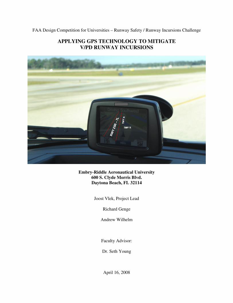
FAA Design Competition for Universities – Runway Safety / Runway Incursions Challenge
APPLYING GPS TECHNOLOGY TO MITIGATE
V/PD RUNWAY INCURSIONS
Embry-Riddle Aeronautical University
600 S. Clyde Morris Blvd.
Daytona Beach, FL 32114
Joost Vlek, Project Lead
Richard Genge
Andrew Wilhelm
Faculty Advisor:
Dr. Seth Young
April 16, 2008
i
Executive Summary
This report addresses the Runway Safety / Runway Incursions Challenge of the FAA Design
Competition for Universities, 2007 – 2008 academic year. The research and proposed technology
presented in this report focuses on a growing segment of runway incursions, vehicle deviations.
Vehicle deviations are the primary segment of overall vehicle/pedestrian incursions (V/PD’s)
which account for nearly 17% of the total runway incursions between 2003 and 2006.
A solution designed to minimize the likelihood of a vehicle incursion by achieve improving
airside ground vehicle drivers’ situational awareness, particularly during times of reduced
visibility, is proposed. The solution proposed is an enhancement of currently market-available
GPS moving map devices, installed in vehicles operating around the airfield, adapted to the
airfield environment and equipped with visual and aural warnings when approaching a runway
environment. The solution was developed by way of a thorough literature review, empirical
research, initial development and testing, interactions with airport operators, the FAA,
technology experts, and members of academia in the fields of flight training, business, and
human factors. Operational models, development and maintenance strategies, and cost-benefit
analyses were performed to justify the applicability of this proposed technology.
Outcomes of research, development, and testing revealed highly successful results. In addition,
cost estimates of implementation on a wider scale are found to be significantly less than
alternative technologies. It is hoped that the technology proposed in this research be considered
for further development.
ii
Table of Contents
1. Introduction / Problem Statement ........................................................................................... 1
2. Background and Literature Review ........................................................................................ 2
2.1 Runway Incursions Defined............................................................................................ 2
2.2 Causes of Runway Incursions......................................................................................... 6
2.3 Focus of Study: V/PD Incursions .................................................................................. 7
2.4 Current Measures to Prevent Runway Incursions......................................................... 10
2.5 Future Technologies...................................................................................................... 18
2.6 Limitations of Current Technologies ............................................................................ 19
3. Team’s Problem Solving Approach to the Design Challenge. ............................................. 20
3.1 Approach and proposed solution to the Design Challenge........................................... 20
3.2 Description of Technology ........................................................................................... 21
3.3 Interaction with industry and academia ........................................................................ 28
4. Safety / Risk Assessment. ..................................................................................................... 30
5. Projected Impacts of Design and Financial Analysis ........................................................... 35
6. Summary and Conclusions ................................................................................................... 38
Appendix A: Contact Information .............................................................................................. A-1
Appendix B: Description of University ...................................................................................... A-2
Appendix C: Description of non-university partners.................................................................. A-4
Appendix D: Design Proposal Submission Form ....................................................................... A-5
Appendix E: Evaluation of Educational Experience .................................................................. A-6
Appendix F: References............................................................................................................ A-12
Appendix G-1: Interview Reports and Meeting Reports .......................................................... A-15
Appendix G-2: Cost Calculations ............................................................................................. A-26
iii
Table of Figures
Figure 2-1: Runway Incursions by Airport, 2003 – 2006............................................................... 4
Figure 2-2: Runway Incursion Severity Categories........................................................................ 4
Figure 2-3: FY 2007 and FY 2008 (Oct-Jan) reported Runway Incursion Data ............................ 5
Figure 3-1: Proposed GPS based satellite navigation system. ..................................................... 21
Figure 3-2: Position referencing using multiple GPS satellites. ................................................... 23
Figure 3-3: Prototype GPS Technology in operations vehicle .................................................... 29
Figure 4-1: Predictive Risk Matrix ............................................................................................... 31
Figure 4-2: Procedure of Updating Digital Maps ......................................................................... 34
Figure 5-1: Per Unit Implementation Cost Estimates .................................................................. 37
Figure 5-2: Costs of GPS Devices per unit Related to Number of Devices Ordered .................. 37
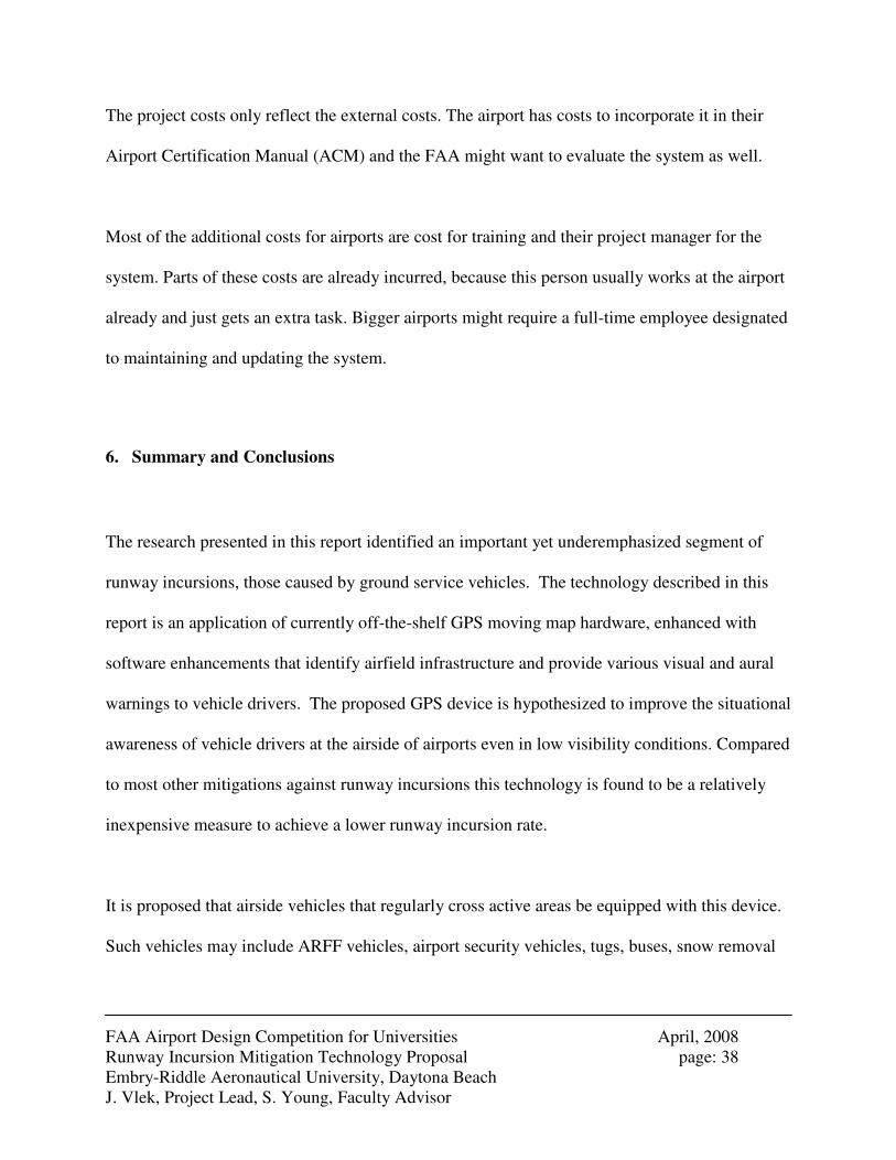
Figure 6-1: Potential Schedule for Pilot Project ........................................................................... 39
iv
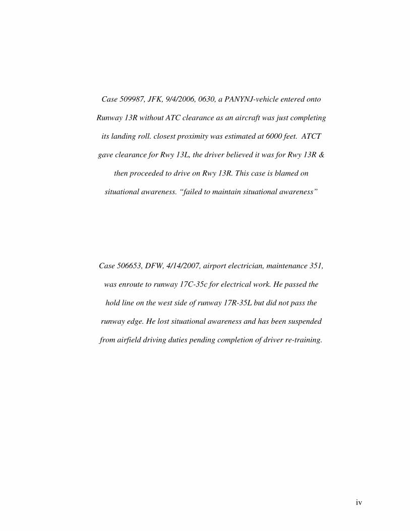
Case 509987, JFK, 9/4/2006, 0630, a PANYNJ-vehicle entered onto
Runway 13R without ATC clearance as an aircraft was just completing
its landing roll. closest proximity was estimated at 6000 feet. ATCT
gave clearance for Rwy 13L, the driver believed it was for Rwy 13R &
then proceeded to drive on Rwy 13R. This case is blamed on
situational awareness. “failed to maintain situational awareness”
Case 506653, DFW, 4/14/2007, airport electrician, maintenance 351,
was enroute to runway 17C-35c for electrical work. He passed the
hold line on the west side of runway 17R-35L but did not pass the
runway edge. He lost situational awareness and has been suspended
from airfield driving duties pending completion of driver re-training.
FAA Airport Design Competition for Universities April, 2008 Runway Incursion Mitigation Technology Proposal page: 1 Embry-Riddle Aeronautical University, Daytona Beach J. Vlek, Project Lead, S. Young, Faculty Advisor
1. Introduction / Problem Statement
This report describes research performed in response to the Federal Aviation Administration’s
“Airport Design Competition for Universities” call for proposals for the 2007 – 2008 academic
year. The research conducted for this proposal was performed by a group of graduate and
undergraduate students at Embry-Riddle Aeronautical University’s Daytona Beach campus,
under the project management of Joost Vlek, graduate student in the university’s MBA program.
The faculty advisor for this project was Dr. Seth Young, Associate Professor in the university’s
College of Business.
The focus of this research falls under the “Runway Safety / Runway Incursions Challenges”
competition category. Specifically, this proposal describes the potential for mitigating runway
incursions caused by ground vehicles operating on an airfield by adapting currently available
GPS moving map navigational technologies to the airfield environment. As this proposal
describes, the results of this research provide a solid foundation supporting the group’s
hypothesis that implementation of such technologies would be beneficial from both an
operational effectiveness and cost efficiency perspective.
This proposal begins by describing runway incursions and identifying current technologies
developed to address runway incursions by way of a comprehensive literature review. The
proposal then describes the group’s proposed technology from a technical perspective, and
provides results of empirical knowledge gained from a variety of sources to support the proposed
technology.
FAA Airport Design Competition for Universities April, 2008 Runway Incursion Mitigation Technology Proposal page: 2 Embry-Riddle Aeronautical University, Daytona Beach J. Vlek, Project Lead, S. Young, Faculty Advisor
2. Background and Literature Review
2.1 Runway Incursions Defined
On October 1, 2007 the FAA adopted the International Civil Aviation Organization’s (ICAO)
definition for runway incursions as “any occurrence at an aerodrome involving the incorrect
presence of an aircraft, vehicle or person on the protected area of a surface designated for the
landing and take-off of aircraft”. Prior to this definition change, the FAA defined incidents
which occur without an aircraft in potential conflict as a “surface incident” and not a runway
incursion, for example, an aircraft crossing an otherwise empty runway without authorization.
[1] This definition change has resulted in a dramatic increase of reported runway incursions, and
an increased emphasis on finding ways to mitigate their occurrences. The technology discussed
in this proposal seeks to address this issue in a focused, feasible, and cost effective manner.
The FAA recognizes three types of runway incursions; Pilot Deviations, Operational Errors /
Deviations, and Vehicle / Pedestrian Deviations.
Pilot Deviations (PD): Pilot deviations are incursions that result from pilots who violate a
Federal Aviation Regulation (FAR). For example, a pilot fails to obey air traffic control
instructions to not cross an active runway when following the authorized route to an airport gate.
[2] This is the most common type of runway incursion.
FAA Airport Design Competition for Universities April, 2008 Runway Incursion Mitigation Technology Proposal page: 3 Embry-Riddle Aeronautical University, Daytona Beach J. Vlek, Project Lead, S. Young, Faculty Advisor
Operational Errors / Deviations (OE/D): Operational errors / deviations are runway incursions
as a result of errors by an air traffic controller. This could vary from breaching minimum
separation requirements, to assigning aircraft operations to closed runway areas, or allowing
aircraft to operate on a runway that has been cleared prior for ground operations or vice versa.
Vehicle / Pedestrian Deviations (V/PD): Vehicle / Pedestrian Deviations are runway incursions
that result from objects (pedestrians, vehicles, etc.) interfering with aircraft operations by
entering or moving on the movement area without authorization from air traffic control,
including ground personnel taxiing or towing aircraft for reasons like maintenance or gate
repositioning. [2]
Between FY2003 and FY2006 (FAA fiscal years beginning Oct 1 of the previous calendar year),
Pilot Deviations were responsible for 54% of all runway incursions. Operational Errors /
Deviations for 29%, and Vehicle / Pedestrian Deviations accounted for 17% in the same period.
[2] Figure 2-1 illustrates the distribution of these runway incursions by category, for the 35
public use airports in the FAA’s Operational Efficiency Program (OEP).
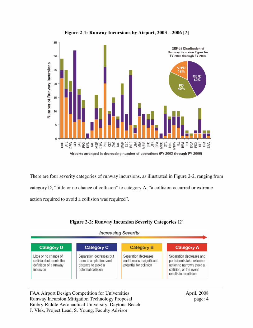
FAA Airport Design Competition for Universities April, 2008 Runway Incursion Mitigation Technology Proposal page: 4 Embry-Riddle Aeronautical University, Daytona Beach J. Vlek, Project Lead, S. Young, Faculty Advisor
Figure 2-1: Runway Incursions by Airport, 2003 – 2006 [2]
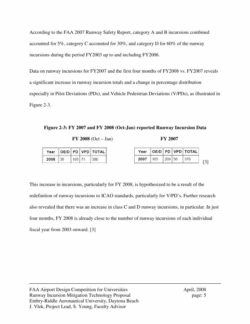
There are four severity categories of runway incursions, as illustrated in Figure 2-2, ranging from
category D, “little or no chance of collision” to category A, “a collision occurred or extreme
action required to avoid a collision was required”.
Figure 2-2: Runway Incursion Severity Categories [2]
FAA Airport Design Competition for Universities April, 2008 Runway Incursion Mitigation Technology Proposal page: 5 Embry-Riddle Aeronautical University, Daytona Beach J. Vlek, Project Lead, S. Young, Faculty Advisor
According to the FAA 2007 Runway Safety Report, category A and B incursions combined
accounted for 5%, category C accounted for 30%, and category D for 60% of the runway
incursions during the period FY2003 up to and including FY2006.
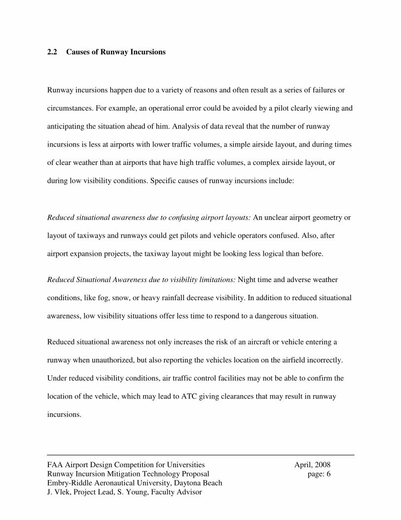
Data on runway incursions for FY2007 and the first four months of FY2008 vs. FY2007 reveals
a significant increase in runway incursion totals and a change in percentage distribution
especially in Pilot Deviations (PDs), and Vehicle Pedestrian Deviations (V/PDs), as illustrated in
Figure 2-3.
Figure 2-3: FY 2007 and FY 2008 (Oct-Jan) reported Runway Incursion Data
FY 2008 (Oct – Jan) FY 2007
[3]
This increase in incursions, particularly for FY 2008, is hypothesized to be a result of the
redefinition of runway incursions to ICAO standards, particularly for V/PD’s. Further research
also revealed that there was an increase in class C and D runway incursions, in particular. In just
four months, FY 2008 is already close to the number of runway incursions of each individual
fiscal year from 2003 onward. [3]
FAA Airport Design Competition for Universities April, 2008 Runway Incursion Mitigation Technology Proposal page: 6 Embry-Riddle Aeronautical University, Daytona Beach J. Vlek, Project Lead, S. Young, Faculty Advisor
2.2 Causes of Runway Incursions
Runway incursions happen due to a variety of reasons and often result as a series of failures or
circumstances. For example, an operational error could be avoided by a pilot clearly viewing and
anticipating the situation ahead of him. Analysis of data reveal that the number of runway
incursions is less at airports with lower traffic volumes, a simple airside layout, and during times
of clear weather than at airports that have high traffic volumes, a complex airside layout, or
during low visibility conditions. Specific causes of runway incursions include:
Reduced situational awareness due to confusing airport layouts: An unclear airport geometry or
layout of taxiways and runways could get pilots and vehicle operators confused. Also, after
airport expansion projects, the taxiway layout might be looking less logical than before.
Reduced Situational Awareness due to visibility limitations: Night time and adverse weather
conditions, like fog, snow, or heavy rainfall decrease visibility. In addition to reduced situational
awareness, low visibility situations offer less time to respond to a dangerous situation.
Reduced situational awareness not only increases the risk of an aircraft or vehicle entering a
runway when unauthorized, but also reporting the vehicles location on the airfield incorrectly.
Under reduced visibility conditions, air traffic control facilities may not be able to confirm the
location of the vehicle, which may lead to ATC giving clearances that may result in runway
incursions.
FAA Airport Design Competition for Universities April, 2008 Runway Incursion Mitigation Technology Proposal page: 7 Embry-Riddle Aeronautical University, Daytona Beach J. Vlek, Project Lead, S. Young, Faculty Advisor
High Traffic Volume: A high intensity of traffic leads to a higher workload for air traffic
controllers. This could result in a higher experience of stress, which in turn could may lead to
incursions as a result of operational error.
Communication errors. Examples are the use of non-standard phraseology, or differences in
standard phraseology, and squelched messages. All of these three factors were involved in the
Tenerife incursion, still the biggest aviation disaster in the world today with 583 fatalities. There
are differences in phraseology between ICAO and FAA standards. One of these differences is the
phraseology used for holding at a runway. This problem especially happens at airports with
international traffic.
2.3 Focus of Study: V/PD Incursions
The technology discussed within this proposal focuses on reducing Vehicle / Pedestrian
Deviations. Therefore, a focused analysis of V/PD incursions is provided.
According to the FAA, a vehicle or pedestrian deviation (V/PD) includes pedestrians, vehicles,
or other objects interfering with aircraft operations by entering or moving on the movement area
without authorization from air traffic control. It is important to note that this runway incursion
type includes mechanics taxiing aircraft for maintenance or gate re-positioning. Sometimes the
pedestrian or vehicle conflicts with an aircraft landing or taking off which could result in a
runway incursion. Even if the vehicle or pedestrian does not enter a runway, the deviation can
FAA Airport Design Competition for Universities April, 2008 Runway Incursion Mitigation Technology Proposal page: 8 Embry-Riddle Aeronautical University, Daytona Beach J. Vlek, Project Lead, S. Young, Faculty Advisor
divert the controller’s attention from aircraft and other vehicles, which could result in an incident
or accident. [2]
Based on empirical FAA runway incursion data for the Chicago O’Hare, Atlanta Hartsfield-
Jackson, and Philadelphia International Airports, the three airports in the United States with the
most V/PD’s, approximately 90% of all V/PDs are vehicle deviations, while under 10% are
caused by pedestrians. At these airports, V/PDs in total, in fact, accounted for between 60 and
75% of all runway incursions on these complex and busy airfields. Many of these deviations
were found to be a result of “lost situational awareness”. Empirical research conducted at the
Daytona Beach International Airport, which has only one reported V/PD, also found that in many
instances, loss of situational awareness, even at less complex or busy airfields, may occur, either
due to reduced visibility, driver distraction, or merely from routine lack of focused concentration.
The FAA’s “Runway Safety Blueprint 2002-2004”, issued in July 2002, “define(s) and
prioritize(s) many of the coordinated efforts between the FAA and the aviation community to
reduce runway incursions”. The document states that “Improved awareness efforts and
compliance are required to reduce runway incursions. A frequent reason runway incursions occur
is loss of situational awareness.” [4]
In August 2007, the FAA issued a Call to Action to all airport operators and vehicle operators to
accept more responsibility for vehicle and pedestrian movements. As a result of the recent Call
FAA Airport Design Competition for Universities April, 2008 Runway Incursion Mitigation Technology Proposal page: 9 Embry-Riddle Aeronautical University, Daytona Beach J. Vlek, Project Lead, S. Young, Faculty Advisor
to Action, the FAA has made the following four recommendations in order to help mitigate
V/PD related runway incursions:
1. All airports with more than 1.5 million annual enplanements to voluntarily accelerate the
enhancement of new markings (Enhanced Taxiway Centerline Markings) that were
originally required by the FAA by June 30, 2008.
2. All airports certificated under Part 139 (with fewer than 1.5 million annual enplanements)
develop plans to voluntarily upgrade existing markings (install Enhanced Taxiway
Centerline Markings), even though it is not required.
3. All other certificated airports to voluntarily develop plans to require annual recurrent
training to all individuals with access to the movement area.
4. Air carriers to establish mandatory recurrent training for non-pilot employees who
operate aircraft or vehicles on the airfield.
In the event of a V/PD the following actions are to take place: [5]
1. The ATCT completes FAA Form 8020-24, Preliminary V/PD Deviation Report.
2. FAA Airports Division issues a Letter of Investigation to the airport operator.
3. The airport operator investigates the incident, initiates corrective actions as appropriate,
and sends a report to the FAA Airports Division.
4. The FAA Airports Division also investigates the incident, reviews the airport’s ground
vehicle program and incident report on the V/PD.
FAA Airport Design Competition for Universities April, 2008 Runway Incursion Mitigation Technology Proposal page: 10 Embry-Riddle Aeronautical University, Daytona Beach J. Vlek, Project Lead, S. Young, Faculty Advisor
5. The Airport Certification Inspector determines appropriate action and issues a closeout
letter, Warning Letter, Letter of Correction, or initiates civil penalty action as a result of
the FAA’s investigation.
6. The Airport Certification Inspector completes FAA Form 8020-25, Investigation of V/PD
Report.
2.4 Current Measures to Prevent Runway Incursions
Numerous measures have been introduced to mitigate or prevent runway incursions. Among
them are new technologies, including facility-based controller notification equipment, ground-
based flight crew notification equipment, on-board flight crew notification systems, and
infrastructural measures.
Various technologies that are considered “Facility-Based Controller Notification Equipment”
include:
Airport Surface Detection Equipment-Model 3 (ASDE-3): ASDE-3 “provides radar surveillance
of aircraft and airport service vehicles at high activity airports to aid in the orderly movement of
aircraft and ground vehicles on the airport surface, especially during low or no visibility
conditions”. [2]
Airport Movement Area Safety System (AMASS): AMASS prompts tower controllers with a
series of lights and sounds to respond to situations on the airfield that will potentially

FAA Airport Design Competition for Universities April, 2008 Runway Incursion Mitigation Technology Proposal page: 11 Embry-Riddle Aeronautical University, Daytona Beach J. Vlek, Project Lead, S. Young, Faculty Advisor
compromise safety. AMASS is an add-on enhancement to the host ASDE-3 radar that provides
automated alerts and warnings to potential runway incursions and other hazards. AMASS
extends the capability of the ASDE-3 and enhances surface movement safety. It is currently
operational at 33 airports.
Airport Surface Detection Equipment, Model X (ASDE-X)” ASDE-X “provides high resolution,
short-range, clutter free surveillance information about aircraft and vehicles, both moving and
fixed, located on or near the surface of the airport movement area under all weather and visibility
conditions”. [2] ASDE-X enables air traffic controllers to detect potential runway conflicts by
providing detailed coverage of movement on runways and taxiways. ASDE-X obtains
identification information from aircraft transponders.
ASDE-X is a more sophisticated surface detection technology than ASDE-3, with AMASS.
While AMASS is radar-based, meaning signals could be less accurate in rain and fog, ASDE-X
integrates data from a variety of sources, which includes radar and aircraft transponders, to give
controllers a more reliable view of airport operations. ASDE-X capabilities will be added to
many of the sites that already have AMASS, as well as to other busy airports.
Ground-Based Flight Crew Notification Equipment technologies include:
Final Approach Runway Occupancy Signal (FAROS): FAROS alerts pilots for potential runway
incursions. FAROS, currently being tested by the FAA at Long Beach Airport, is a “fully
FAA Airport Design Competition for Universities April, 2008 Runway Incursion Mitigation Technology Proposal page: 12 Embry-Riddle Aeronautical University, Daytona Beach J. Vlek, Project Lead, S. Young, Faculty Advisor
automated system using inductive loop sensors embedded in the runway and taxiway surfaces to
detect aircraft and vehicles entering and exiting the monitored zones”. [2] When the runway is
occupied by a potentially hazardous target, the system flashes the Precision Approach Path
Indicator (PAPI) lights as a visual indicator to pilots on approach without controller input.
Runway Status Lights (RWSL): RWSL alert pilots for potential runway incursions. RWSL is a
supplement to existing pilot procedures, training and visual monitoring. The lights operate
automatically and are controlled via processing of surface surveillance information without the
need for controller input. RWSL has two components, namely Runway Entrance Lights (RELs)
and Takeoff-Hold Lights (THLs).
Surface and terminal surveillance systems, such as ASDE-X and AMASS, detect the presence
and motion of aircraft and vehicles on or near the runways; the Runway Status Light safety logic
then assesses any possible conflicts with other surface traffic. Red in-pavement runway entrance
lights are illuminated if the runway is unsafe for entry or crossing, and red in-pavement takeoff
hold lights are illuminated if the runway is unsafe for departure. THLs have been installed and
have been under evaluation at DFW since January, 2006. [2]
Runway Incursion Prevention System (RIPS): RIPS integrates several advanced technologies
into a surface communication, navigation and surveillance system for flight crews and air traffic
controllers. RIPS came out through NASA’s Langley Research Center and the FAA. “RIPS
combines a head-down cockpit display of an electronic moving map of airport runways and
FAA Airport Design Competition for Universities April, 2008 Runway Incursion Mitigation Technology Proposal page: 13 Embry-Riddle Aeronautical University, Daytona Beach J. Vlek, Project Lead, S. Young, Faculty Advisor
taxiways with a head-up display that gives pilots real-time guidance.” [6]. The system shows and
sounds an alert if another plane or vehicle is about to encroach onto the runway. “RIPS also uses
specially developed computer software, GPS signals and ground technologies developed by the
FAA's Runway Incursion Reduction Program” (Runway Incursion). Components of the systems
include technologies that will provide flight crews with vital airborne and ground information,
including terrain, ground obstacles, air traffic, landing and approach patterns and detailed airport
surface maps.
“Research during both simulation and flight tests for commercial and business aircraft operations
has demonstrated that these technologies can significantly increase situational awareness and
reduce the occurrence of runway incursions.” [7] However, the experiment, at Dallas / Fort
Worth (DFW), showed large individual differences between pilots and their awareness. On the
other hand, researchers did come to the conclusion that aural and graphical alerting systems
prevented pilots from maneuvering into runway incursion situation, since the incursion aircraft
received an alert before taxiing onto the active runway. [6, 7]
Autonomous Runway Incursion Prevention System (ARIPS): On September 7, 2006, Norris
Electro Optical Systems Corporation conducted a successful demonstration of the Autonomous
Runway Incursion Prevention System (ARIPS), at the T. F. Green Airport, Providence, Rhode
Island. ARIPS was specifically designed to detect and prevent airport runway collisions or
incursions by providing instantaneous and direct warnings to flight crews. ARIPS employs
FAA Airport Design Competition for Universities April, 2008 Runway Incursion Mitigation Technology Proposal page: 14 Embry-Riddle Aeronautical University, Daytona Beach J. Vlek, Project Lead, S. Young, Faculty Advisor
ultraviolet light that is not affected by fog, rain or other weather conditions detrimental to safe
airport operations.
Automatic Dependent Surveillance-Broadcast (ADS-B): ADS-B is a system that is based on a
satellite Global Position System (GPS). It is intended to keep safer and shorter distances between
aircraft in flight and on runways. The system uses transponders in aircraft to determine exact
aircraft position, heading, air speed, its flight number and whether the aircraft is turning,
climbing, or descending. The signal contains information that is updated, via satellite, every
second, which provides much more accuracy for pilots in the air and on the ground as well as for
controllers and airport operating personnel. ADS-B uses ground stations that have a sending
radius of 150 to 200 miles. “ADS-B ground stations add radar-based targets for non-ADS-B-
equipped aircraft to the mix and send all of the information back up to the equipped aircraft –
this function is called Traffic Information Service-Broadcast (TIS-B)”. [8] It also gathers
National Weather Service and flight information, and sending them back up in a graphical format
– this function is called Flight Information Service-Broadcast (FIS-B). ADS-B is not only a
system for the sky, it will also reduce the risk of runway incursions through a mapping system
that will provide precise location of aircraft on the airfield, that will give pilots and air traffic
controllers better chances to organize airfield traffic even in bad weather conditions. [8]
United Parcel Service (UPS) and other U.S. cargo carriers conducted ADS-B operational test
first in 1999, installing the system in four of their aircraft each, to collect and evaluate the data.
Operational service showed some weak links in the system but Human Factor experts from
FAA Airport Design Competition for Universities April, 2008 Runway Incursion Mitigation Technology Proposal page: 15 Embry-Riddle Aeronautical University, Daytona Beach J. Vlek, Project Lead, S. Young, Faculty Advisor
NASA evaluated the system during the trails and suggested several changes to the system to
make it more effective. As of today, UPS has already committed to installing the system in its
entire fleet. [9] On May 31, 2007, the FAA Capstone Program came to a major success when
ADS-B technology got approved for air traffic separation in Alaska airspace, and it will soon be
further developed for its deployment on a national basis. [10]
The FAA and the aviation industry are working very hard to make ADS-B succeed. RTCA (a
scientific advisory group that assists the FAA on technical issues) and ICAO are responsible for
the systems standards and procedures. Manufacturers of avionics for equipment needed to
support the new technology are Garmin AT and Chelton Flight Systems. Ground Infrastructure
technology will be developed by companies like Sensis Corporation, Thales, ERA, and CNS
Systems. [11] The Program by the FAA for the implementation of ADS-B on the east coast of
the United States is called “Safe Flight 21”. The program is based on the same systems and
principles as the approved Capstone Program in Alaska. [12]
Embry-Riddle Aeronautical University currently implements ADS-B in its fleet of training
aircraft. As part of this study, empirical analysis was performed to fully understand the benefits
of this technology.
Runway Awareness and Advisory System (RAAS): Developed by Honeywell, RAAS is “designed
to provide additional information on the aircraft position relative to runways during surface
operations and on final approach … by delivering aural advisories”. The advisories catalog
FAA Airport Design Competition for Universities April, 2008 Runway Incursion Mitigation Technology Proposal page: 16 Embry-Riddle Aeronautical University, Daytona Beach J. Vlek, Project Lead, S. Young, Faculty Advisor
includes “10 advisories that are generated on the basis of aircraft inputs to an Enhanced Ground
Proximity Warning System (EGPWS), such as GPS position, heading and ground speed, in
conjunction with a runway database.” [13] The advisories of the system include 5 routine
advisories when an aircraft is approaching a runway in the air, on the ground, or on the runway
itself. RAAS is using the database inputs to generate the applicable advisory. Another five
advisories of RAAS are non-routine advisories that try to draw the pilot’s attention in dangerous
situations in the air and on the ground. For RAAS usage, an aircraft need to posses an EGPWS in
the version Mk V or Mk VII which has a source of GPS data and terrain database. [13]
Surface Area Movement Manager (SAMM): A system similar to RAAS is SAMM, developed by
the Aviation Communication Surveillance Systems (ACSS) and United Parcel Service (UPS).
SAMM is part of the ADS-B’s SafeRoute application suite, “it provides an airport surface map
and tracks the movement of the crew’s own aircraft plus other ground and airborne traffic in the
terminal area.” [13]
Infrastructure Measures include:
Runway Lead-On Lights: Enhanced taxiway lighting, has been implemented at intersections of
taxiways to runways. While normal taxiway centerline lights are green, when approaching a
runway the lights are alternated green and yellow, to enhance awareness of a runway intersection
in the immediate vicinity.
FAA Airport Design Competition for Universities April, 2008 Runway Incursion Mitigation Technology Proposal page: 17 Embry-Riddle Aeronautical University, Daytona Beach J. Vlek, Project Lead, S. Young, Faculty Advisor
Perimeter Taxiways : Perimeter taxiways eliminate the need for crossing runways. A downside is
that some perimeter taxiways result in excessive taxiing times, as is the case at Amsterdam
Airport Schiphol (AMS). Hartsfield-Jackson Atlanta International Airport was the first airport in
the country to build a perimeter taxiway in 2007. Construction has begun on perimeter taxiways
for the southeast section of Dallas-Fort Worth International Airport.
Modified runway geometries; The geometry along runway 7R-25L at Los Angeles International
Airport (LAX) is such that its high-speed exit taxiways directly lead to parallel runway 7L-25R.
Currently, LAX is addressing this by adjusting its airside geometry. There are plans to construct
a parallel taxiway in between parallel runways, so that rapid exit taxiways and exit taxiways do
not lead directly onto another active runway.
Retro-Reflective Marking: The use of retro-reflective marking at holding bars, standard at a lot
of airports, could provide more clarity to the users of the airport.
Enhanced Surface Markings : AC 150/5340-1J [14] incorporates guidance on the use of the
enhanced taxiway centerline markings and the surface holding position signs. Previously,
taxiway centerlines were marked with a solid yellow line. These modifications include dashed
yellow lines on either side of the solid line in or near the area of a runway.
Finally, training of airport ground vehicle drivers will teach the drivers where they can go
without ATC clearance, and that they know the procedures if they do need clearance. To aid in
FAA Airport Design Competition for Universities April, 2008 Runway Incursion Mitigation Technology Proposal page: 18 Embry-Riddle Aeronautical University, Daytona Beach J. Vlek, Project Lead, S. Young, Faculty Advisor
airfield driver training, the FAA has published an airport ground vehicle operations (AGVO)
guide that “provide(s) a general overview of safe procedures for driving on an airport”. [15]
2.5 Future Technologies
Embry-Riddle Aeronautical University’s “Integrated Airport” Research
Embry-Riddle Aeronautical University, in partnership with the Lockheed-Martin Corporation,
has begun to perform research on future technologies to improve efficiency and effectiveness at
airports across the globe, as part of its “Integrated Airport” research program. The objective is to
connect all aspects of the airport so that the correct information is being transmitted to the right
individuals at the right time, allowing them to make smart and knowledgeable decisions in
different situations. The benefits of this system would be astonishing with the most important
being the protection against runway incursions.
Some technologies are being considered include:
1. Airport Wide Information Management (AWIN): AWIN provides the ability to
exchange information and connection with the FAA SWIM network.
2. System Wide Information Management (SWIM): SWIM is a technology that the
FAA is in the process of developing to help with the sharing of FAA information
such as temporary flight restrictions (TFRs), NOTAMS and the conditions of
navigational aids.
FAA Airport Design Competition for Universities April, 2008 Runway Incursion Mitigation Technology Proposal page: 19 Embry-Riddle Aeronautical University, Daytona Beach J. Vlek, Project Lead, S. Young, Faculty Advisor
3. Automated Dependent Surveillance Broadcast (ADS-B)
4. Cameras that view aircraft departing and arriving
5. Virtual Camera System that displays all airport activity
6. Advanced Light Detection and Ranging (LIDAR). LIDAR identifies the hazards for
aircraft, such as wind hazards and wake vortices.
2.6 Limitations of Current Technologies
Nearly all of the current systems look at warning only pilots about potential dangers. Since the
majority of total runway incursions are due to pilot error or other reasons dealing with the pilots,
there is justification for targeting pilot deviations. However, there are few systems that account
for the approximately 17% of runway incursions that involve ground vehicles. Although
enhanced markings are useful in helping to prevent incursions, they are only useful when they
can be seen. During low visibility conditions the ground vehicles and taxiing aircraft may not see
the markings or may proceed to get on the incorrect taxiway. These errors are easily preventable
but still remain a potential reason for incursions to take place.
Most recently, The FAA and industry representatives announced a five-point, short-term
Runway Safety Plan to quickly implement and improve runway safety at airports in the United
States. [16] The reason for the Runway Safety Plan is the acknowledgement of “recent close
calls” at some of the busiest airports in the country that required immediate action. The Runway
Safety Plan concluded solutions in four main areas: cockpit procedure, airport signage and
markings, air traffic procedures, and technology. The FAA and the aviation community gave
FAA Airport Design Competition for Universities April, 2008 Runway Incursion Mitigation Technology Proposal page: 20 Embry-Riddle Aeronautical University, Daytona Beach J. Vlek, Project Lead, S. Young, Faculty Advisor
itself 60 days to go over and improve the topics stated above. However, mid- and long-term goal
areas include maximizing situational awareness, minimizing pilot distractions, and eliminating
runway incursions using procedures and technology. [16]
3. Team’s Problem Solving Approach to the Design Challenge.
3.1 Approach and proposed solution to the Design Challenge
The design challenge addressed in this research was to develop a technology which would
contribute to the reduction of runway incursions caused by ground vehicles. The team identified
a set of criteria by which any developed technology would be evaluated. These criteria were:
• Effectively improves vehicle driver’s situational awareness
• Actively provides alerts to drivers
• Effectively utilizes currently available “off-the-shelf” technologies
• Is flexible in its functionality
• Is cost effective to develop, implement, and maintain
Most of the current and future runway mitigation technologies focus on systems that warn pilots
and/or air traffic controllers of potential incursions. This sounds reasonable, because these are
the sources that are responsible for over 80% of all runway incursions. On the other hand, while
possibly helpful for pilots and controllers, it also gives these persons more tasks, or more data to
FAA Airport Design Competition for Universities April, 2008 Runway Incursion Mitigation Technology Proposal page: 21 Embry-Riddle Aeronautical University, Daytona Beach J. Vlek, Project Lead, S. Young, Faculty Advisor
process. Most existing systems also do not improve the situational awareness of, or provide any
runway incursion warnings to, ground vehicle drivers.
3.2 Description of Technology
It is clear from both literature and empirical research that at the busiest airports with the most
complex airfields, V/PDs caused by lack of situational awareness are significant in numbers and
potential severity, and have the greatest potential of benefiting from the technology described.
As discussed in the 2002 FAA Runway Safety Blueprint, the FAA Runway Incursion Joint
Safety Implementation Team determined that the moving map display systems were the most
powerful intervention for runway incursion prevention. The FAA Blueprint states that
“improving situational awareness of airport vehicle drivers with the voluntary implementation of
moving maps in vehicles that operate on the airport……would help prevent runway incursions
caused by driver error and enhance their understanding of the operations on the airport.” [4]
Based on the above criteria, the team focused on adapting a portable satellite-based navigation
equipment, that is, a GPS unit, with moving map technology, to the airfield environment. This
proposed satellite navigation technology has recently widely been accepted for use in cars in
cities and on highways, for the purpose of providing directions and information about various
facilities and services, not for preventing incursions. However, the hypothesis is that such
technologies can help reduce runway incursions on an airfield, as well.
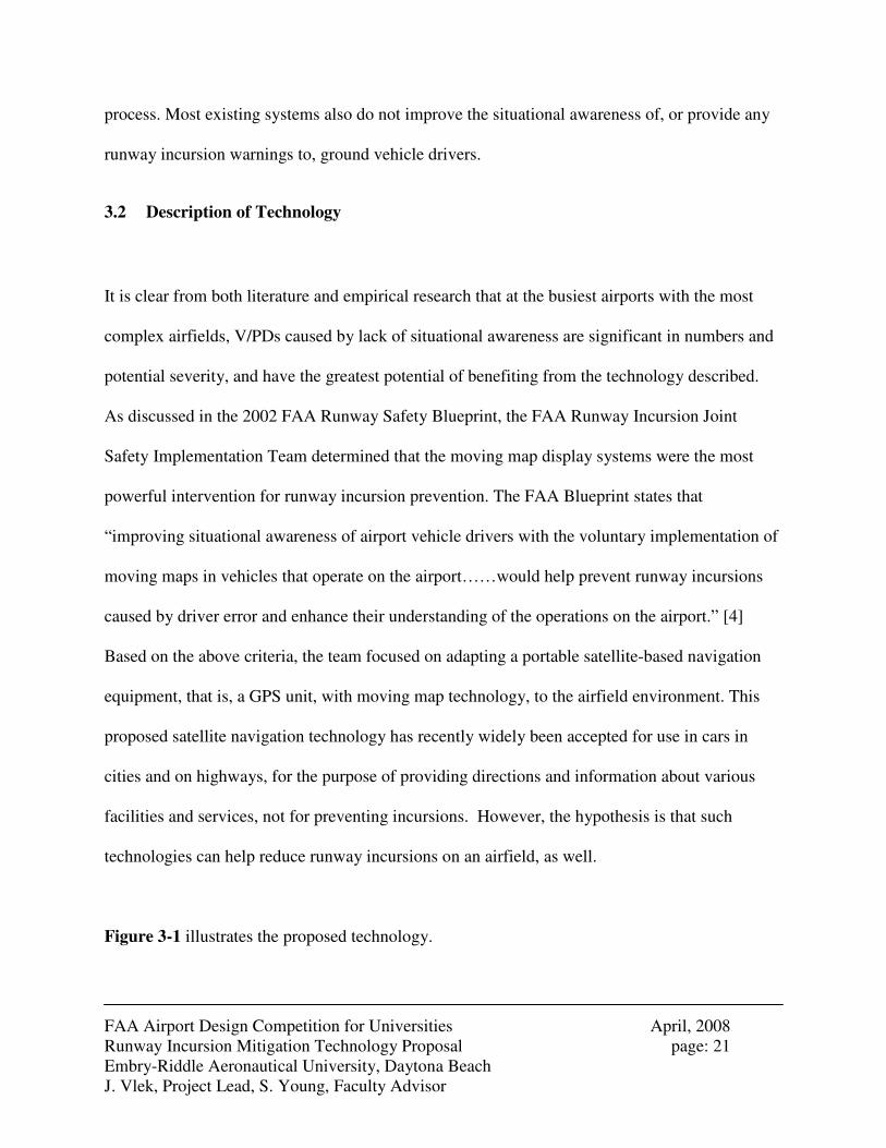
Figure 3-1 illustrates the proposed technology.
FAA Airport Design Competition for Universities April, 2008 Runway Incursion Mitigation Technology Proposal page: 22 Embry-Riddle Aeronautical University, Daytona Beach J. Vlek, Project Lead, S. Young, Faculty Advisor
Figure 3-1: Proposed GPS based satellite navigation system
The vehicles targeted for implementation of this proposed technology are those airside vehicles
that regularly cross active airfield movement areas. Such vehicles include: ARFF vehicles,
airport security vehicles, tugs that reposition aircraft for a gate change or haul to a maintenance
hangar across the runway, buses that take passengers to and from remote aprons, snow removal
vehicles, de-icing trucks, and whichever other vehicle crossing active areas, or whichever other
vehicle that airports or airlines feel should be equipped.
The technology developed for this research is based on the GPS, or Global Positioning System.
The official name is NAVSTAR GPS. It is operated by the United States Department of Defense.
Comparable systems are the European Galileo Positioning System, under construction and
interoperable with GPS, and the currently under restoration Russian GLONASS. China, India,
and Japan are developing various comparable satellite systems as well.
FAA Airport Design Competition for Universities April, 2008 Runway Incursion Mitigation Technology Proposal page: 23 Embry-Riddle Aeronautical University, Daytona Beach J. Vlek, Project Lead, S. Young, Faculty Advisor
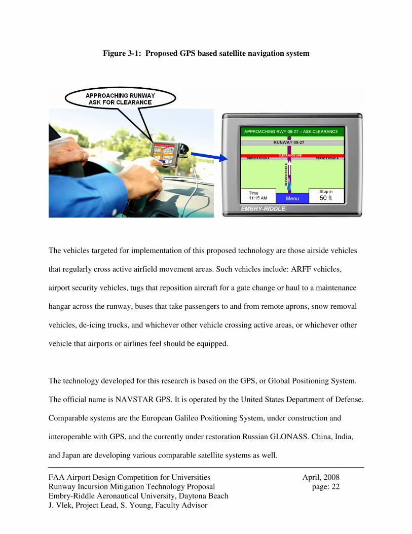
As of January 2006 there are 29 GPS satellites in the nominal 24-satellite constellation. The
satellites broadcast ranging codes and navigation data on two frequencies using a technique
called code division multiple access (CDMA). [17] Both frequencies were chosen due to their
low interference levels with each other, or with other transmitting satellites. GPS references
multiple satellites to triangulate an exact position, as illustrated in Figure 3-2. Once a GPS
receiver is switched on and a signal is acquired, the built-in software processes the codes sent by
the satellites and outputs the specific location in terms of latitude, longitude, and height. To aid
in automobile navigation, the software often references its position against a database of
reference points, including roads and other points of interest. For vehicles operating on an
airfield, a similar database of airfield infrastructure, waypoints, and critical intersections, would
be created.
Figure 3-2: Position referencing using multiple GPS satellites.
Until the year 2000, the United States Government reserved the right of switching the system to
“Selective Availability”, to intentionally degrade the accuracy of the system, for example in

FAA Airport Design Competition for Universities April, 2008 Runway Incursion Mitigation Technology Proposal page: 24 Embry-Riddle Aeronautical University, Daytona Beach J. Vlek, Project Lead, S. Young, Faculty Advisor
times of war. The idea behind Selective Availability was that an enemy could not accurately use
GPS against the United States in warfare offensives. In 2000, the accuracy was limited to 100
meters in the horizontal and 156 meters in the vertical directions. [18] After 2000, a differential,
or relative positioning, method use employed. This method uses two receivers which
simultaneously track the same GPS signal. [17] Using today’s technology, the accuracy has
increased from a few meters to only a few millimeters. This is accurate enough for applications
including driver navigation on public road networks, or to aid vehicles in navigating around an
active airfield.
The GPS device output is the vehicle’s location shown on a display. The display shows an
Airport Moving Map that indicates holding bars, signs, and runways, taxiways and service roads
including their name. Furthermore, warning indicators would include a depiction of the runway
safety area through a red line indicated as “clearance line”. This is called “geo-fencing”. In
addition, audio warnings may be programmed. For example, when approaching a runway safety
area the device will give a voice prompt that says, for example, “Approaching Runway 09 – 27;
ask for clearance” along with providing a text prompt with the same message.
The device should be placed in the middle of the vehicle’s dashboard, close to the window,
rotated to face the driver, in order not to lose sight of the surroundings ahead, and to minimize
distraction.
FAA Airport Design Competition for Universities April, 2008 Runway Incursion Mitigation Technology Proposal page: 25 Embry-Riddle Aeronautical University, Daytona Beach J. Vlek, Project Lead, S. Young, Faculty Advisor
The GPS receiver equipped in ground vehicles is proposed to have the following minimum
requirements:
� Power button.
� GPS chip that processes location and software rendering 3D maps and own position.
� Airport Moving Map to be loaded onto device.
� Mini-USB connector or memory slot card that enables map-uploads.
Alternative, more expensive technology wise, is to upload the devices wireless, for
example by GSM. This will require antennae on the devices and extra software.
� Voice Prompts software. Voice prompt could be provided in any language.
� Volume knob.
� Display size 2.8" wide by 2.1" high or bigger; brightness adjustable.
� Zoom function. Touch screen enables zooming in and out on map.
� Display resolution, WxH: 320 x 240 pixels or bigger.
� Display type: QVGA color antiglare TFT with white backlight.
� Device to be powered by vehicle battery to prevent usage of disposable or rechargeable
batteries that last 4 to 8 hours only.
� Device to be mounted to vehicle to prevent theft, or any other appropriate theft
preventative measure.
� Device to be protected against weather elements where applicable and where subject to
outside influences; extreme heat, cold, rain, snow, hail.
FAA Airport Design Competition for Universities April, 2008 Runway Incursion Mitigation Technology Proposal page: 26 Embry-Riddle Aeronautical University, Daytona Beach J. Vlek, Project Lead, S. Young, Faculty Advisor
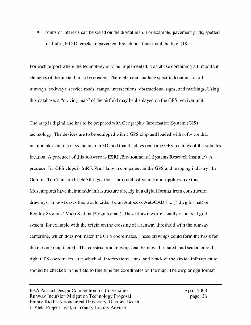
� Points of interests can be saved on the digital map. For example, pavement grids, spotted
fox holes, F.O.D, cracks in pavement breach in a fence, and the like. [18]
For each airport where the technology is to be implemented, a database containing all important
elements of the airfield must be created. These elements include specific locations of all
runways, taxiways, service roads, ramps, intersections, obstructions, signs, and markings. Using
this database, a “moving map” of the airfield may be displayed on the GPS receiver unit.
The map is digital and has to be prepared with Geographic Information System (GIS)
technology. The devices are to be equipped with a GPS chip and loaded with software that
manipulates and displays the map in 3D, and that displays real-time GPS readings of the vehicles
location. A producer of this software is ESRI (Environmental Systems Research Institute). A
producer for GPS chips is SiRF. Well-known companies in the GPS and mapping industry like
Garmin, TomTom, and TeleAtlas get their chips and software from suppliers like this.
Most airports have their airside infrastructure already in a digital format from construction
drawings. In most cases this would either be an Autodesk AutoCAD file (*.dwg format) or
Bentley Systems’ MicroStation (*.dgn format). These drawings are usually on a local grid
system, for example with the origin on the crossing of a runway threshold with the runway
centerline, which does not match the GPS coordinates. These drawings could form the basis for
the moving map though. The construction drawings can be moved, rotated, and scaled onto the
right GPS coordinates after which all intersections, ends, and bends of the airside infrastructure
should be checked in the field to fine tune the coordinates on the map. The dwg or dgn format
FAA Airport Design Competition for Universities April, 2008 Runway Incursion Mitigation Technology Proposal page: 27 Embry-Riddle Aeronautical University, Daytona Beach J. Vlek, Project Lead, S. Young, Faculty Advisor
would be converted into a GIS digital map software format and inserted into a GIS drawing file
with moving map compatibility for integration with other data that will be shown on the GIS
map.
This technology may be developed to different levels of sophistication. The more sophisticated
device may have more features. The strength of this device is the use of common GPS
technology to keep costs low. Proposed features associated with increasing levels of
sophistication may include:
• Device shows location, surrounding runways, taxiways, service roads, aprons, and
clearance areas.
• Voice prompts when approaching a runway intersection.
• Runway incursion “hot spots” are displayed on the device
• Pre-determined routes are given to ground vehicles shown, inclusive of cleared areas and
where to hold
• Real time, other traffic visible (aircraft and ground vehicles)
Applied GPS technologies are progressing in the marketplace at a fast pace, in part integrating
with cell phone technologies. Garmin’s map supplier has been acquired by cell phone
manufacturer Nokia. Software that combines GPS techniques with cell-tower triangulation has
been developed to make it possible that people can see on a map on their cell phone the location
of other cell phone users. [19] This technology currently does not offer real time updates
FAA Airport Design Competition for Universities April, 2008 Runway Incursion Mitigation Technology Proposal page: 28 Embry-Riddle Aeronautical University, Daytona Beach J. Vlek, Project Lead, S. Young, Faculty Advisor
required for airfield operations. [20] As such, the technology researched in this project is limited
to basic levels of sophistication, offering visual and aural queues of airfield location.
3.3 Interaction with industry and academia
As part of this research, prototype technology was developed and tested at the Daytona Beach
International Airport. In addition, presentations of this technology were made to other members
of industry and academia, including the Denver International Airport, flight instructors, flight
students, and faculty of the Human Factors and Business Administration departments at Embry-
Riddle Aeronautical University. Discussions with other partners included, Atlanta Hartsfield-
Jackson International Airport, Atlanta, Georgia, and Tele Atlas. In addition, the FAA Office of
Runway Safety provided the research team with a complete database of V/PD incidents. Details
of interactions with these groups are found in Appendix G-1 of this document. Through these
interactions, the technology was assessed for its potential ability to reduce vehicle runway
incursions, its overall user-ability, and its potential risks to otherwise normal airfield operations.
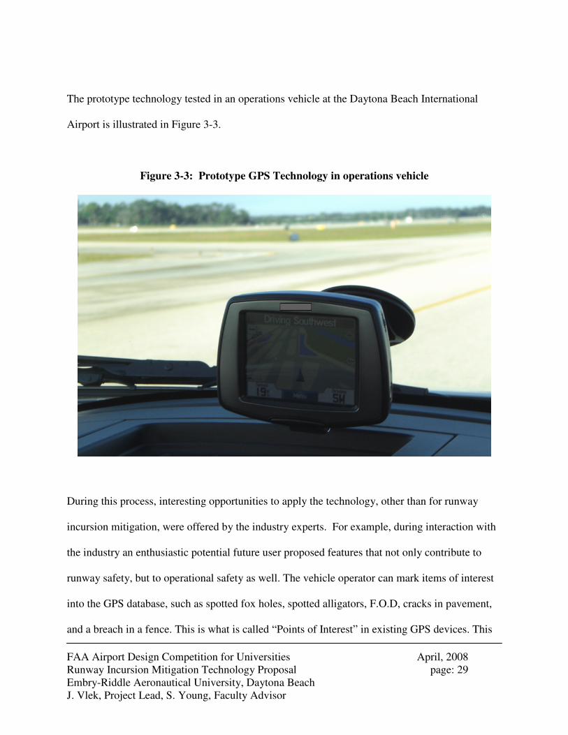
FAA Airport Design Competition for Universities April, 2008 Runway Incursion Mitigation Technology Proposal page: 29 Embry-Riddle Aeronautical University, Daytona Beach J. Vlek, Project Lead, S. Young, Faculty Advisor
The prototype technology tested in an operations vehicle at the Daytona Beach International
Airport is illustrated in Figure 3-3.
Figure 3-3: Prototype GPS Technology in operations vehicle
During this process, interesting opportunities to apply the technology, other than for runway
incursion mitigation, were offered by the industry experts. For example, during interaction with
the industry an enthusiastic potential future user proposed features that not only contribute to
runway safety, but to operational safety as well. The vehicle operator can mark items of interest
into the GPS database, such as spotted fox holes, spotted alligators, F.O.D, cracks in pavement,
and a breach in a fence. This is what is called “Points of Interest” in existing GPS devices. This
FAA Airport Design Competition for Universities April, 2008 Runway Incursion Mitigation Technology Proposal page: 30 Embry-Riddle Aeronautical University, Daytona Beach J. Vlek, Project Lead, S. Young, Faculty Advisor
will enable the vehicle driver to return to these locations without searching for them again. This
saves time and will lead to less interruption of operations when the point of interest would be
located in an active area. At present, many vehicle drivers use (distracting) sticky notes for this.
Another feature that could be incorporated, as suggested by an Operations Supervisor at Daytona
Beach International Airport, is the idea of creating pavement grids. These grids divide the
pavement into sections, to enhance the ability to find beck certain locations. Moreover, the
location of each vehicle could be recorded continuously, so that if a runway incursion has
occurred, authorities could verify whether or not a particular vehicle has been involved.
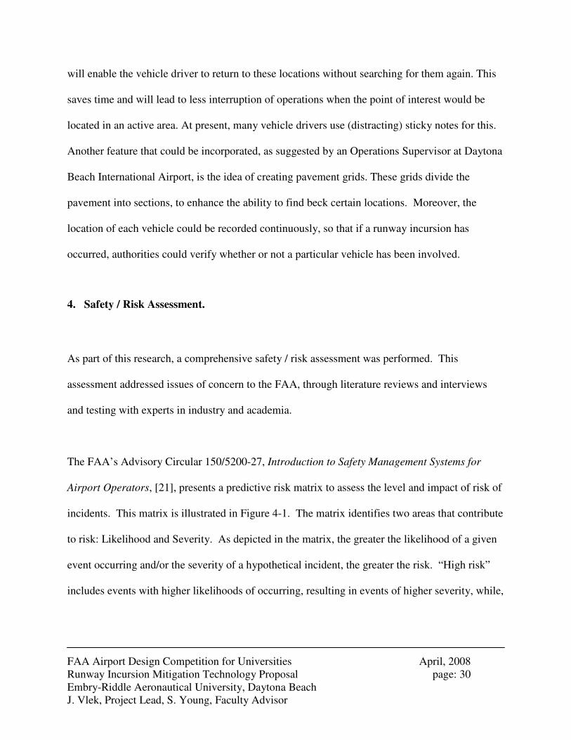
4. Safety / Risk Assessment.
As part of this research, a comprehensive safety / risk assessment was performed. This
assessment addressed issues of concern to the FAA, through literature reviews and interviews
and testing with experts in industry and academia.
The FAA’s Advisory Circular 150/5200-27, Introduction to Safety Management Systems for
Airport Operators, [21], presents a predictive risk matrix to assess the level and impact of risk of
incidents. This matrix is illustrated in Figure 4-1. The matrix identifies two areas that contribute
to risk: Likelihood and Severity. As depicted in the matrix, the greater the likelihood of a given
event occurring and/or the severity of a hypothetical incident, the greater the risk. “High risk”
includes events with higher likelihoods of occurring, resulting in events of higher severity, while,
FAA Airport Design Competition for Universities April, 2008 Runway Incursion Mitigation Technology Proposal page: 31 Embry-Riddle Aeronautical University, Daytona Beach J. Vlek, Project Lead, S. Young, Faculty Advisor
“low risk” includes events with less likelihood of occurrence or events with minimal or minor
safety effects.
It is hypothesized that the technology presented in this study would reduce overall risk of vehicle
runway incursions by reducing the likelihood of occurrence, primarily by improving situational
awareness of vehicle operators.
Figure 4-1: Predictive Risk Matrix [21]
In addition to the FAA’s Safety Management program advisory circular, the 2002 FAA Runway
Safety Blueprint states that “human factors” is the common denominator in every runway
Goal: Reduce risk by reducing likelihood of occurrence
FAA Airport Design Competition for Universities April, 2008 Runway Incursion Mitigation Technology Proposal page: 32 Embry-Riddle Aeronautical University, Daytona Beach J. Vlek, Project Lead, S. Young, Faculty Advisor
incursion. Therefore, minimizing human factors issues were a focus of this study’s safety / risk
assessment.
Human factors issues associated with the proposed technology that may inhibit the mitigation of
runway incursions include creating an additional distraction to drivers, and concerns associated
with inaccuracies or obsolescence of any airfield database.
During meetings with airfield operators at the Daytona Beach International Airport and Denver
International Airport, as well as with members of the faculty in the Human Factors department at
Embry-Riddle Aeronautical University, it became clear that distraction of the driver by a GPS
device was an issue of concern. One human factors professor suggested that the distraction
might cause even further loss of situational awareness.
Published literature supports this concern, particularly for ordinary motor vehicles. “Potentially,
the use of such sophisticated systems while driving could adversely affect the ability of drivers to
control their vehicles safely and respond to potential hazards. Lack of attention and distraction
are already major contributory factors in many road accidents. Therefore, any system which
might add to this problem must be carefully designed. In this respect, it is critical that vehicle
navigation systems provide appropriate information when and where needed in a form that is
easily digested by the driver.” [22]
FAA Airport Design Competition for Universities April, 2008 Runway Incursion Mitigation Technology Proposal page: 33 Embry-Riddle Aeronautical University, Daytona Beach J. Vlek, Project Lead, S. Young, Faculty Advisor
In an effort to minimize visual distraction, the location of the device during field testing was
placed in the middle of the dashboard, facing the driver, just like the GPS devices in personal
automobiles. In testing, the test driver did not have to turn or lower his head to see the screen and
hence did not lose sight of the outside surroundings. Other items found in the vehicles, such as a
working laptop computer and various radio transceivers, were found to have yielded a much
greater likelihood of driver distraction, according to the driver.
During testing at the Daytona Beach International Airport, the GPS unit did not cause any
distraction, and in fact, was revealed to aid in situational awareness during an event which
required ARFF deployment and immediate response.
Some concerns regarding any audio warning functionality of the GPS unit, such as giving
directions or providing audio warning when approaching a potential incursion area still exist, as
feedback from field testing and human factors research reveal that additional audio inputs in an
already busy audio environment create additional driver distractions. In field testing, it was
apparent that audio instructions from the air traffic control tower, communications via cell
phone, combined with local radio communications provided a cluttered audio environment, and
adding an audio functionality to the GPS unit technology may be at the sacrifice of concentrating
on other audio inputs.
Airport layouts are subject to change, especially at bigger airports or airports that grow. It is
therefore of vital importance that the maps keep being updated every time there is a physical
FAA Airport Design Competition for Universities April, 2008 Runway Incursion Mitigation Technology Proposal page: 34 Embry-Riddle Aeronautical University, Daytona Beach J. Vlek, Project Lead, S. Young, Faculty Advisor
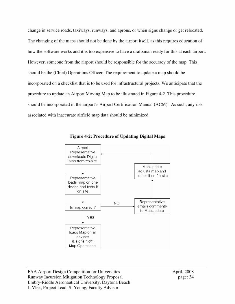
change in service roads, taxiways, runways, and aprons, or when signs change or get relocated.
The changing of the maps should not be done by the airport itself, as this requires education of
how the software works and it is too expensive to have a draftsman ready for this at each airport.
However, someone from the airport should be responsible for the accuracy of the map. This
should be the (Chief) Operations Officer. The requirement to update a map should be
incorporated on a checklist that is to be used for infrastructural projects. We anticipate that the
procedure to update an Airport Moving Map to be illustrated in Figure 4-2. This procedure
should be incorporated in the airport’s Airport Certification Manual (ACM). As such, any risk
associated with inaccurate airfield map data should be minimized.
Figure 4-2: Procedure of Updating Digital Maps
FAA Airport Design Competition for Universities April, 2008 Runway Incursion Mitigation Technology Proposal page: 35 Embry-Riddle Aeronautical University, Daytona Beach J. Vlek, Project Lead, S. Young, Faculty Advisor
Other, unexpected risks associated with the implementation of this technology may involve
behavioral user interaction. For example, some drivers might have a wrong attitude towards the
technology, perhaps trying to break the device when they caused a runway incursion, so that this
person could claim that his device did not work. This would be a communication break-down
between humans and technology. It will be helpful to make the drivers report immediately when
the device does not work properly, as part of a non-punitive safety reporting system supported by
management as suggested in the FAA Advisory Circular AC 150/5200-37 “Introduction to
Safety Management Systems (SMS) for airport operators” [21]
5. Projected Impacts of Design and Financial Analysis
According to the FAA Runway Safety Report [2], the FAA aims to reduce the severity, number
and rate of runway incursions through the mitigation of errors that contribute to collision risks. In
fact, the report specifically mentions that “own-ship positioning equipment” will improve
situational awareness. The FAA Blueprint indicates this more explicitly and even mentions
situational awareness for vehicle drivers in this context and explains that increased situational
awareness will reduce the chance on runway incursions. As such, it is evident, that the
technology proposed in this study meets the FAA goals of improving runway safety and
mitigating V/PD runway incursions by improving situational awareness.
FAA Airport Design Competition for Universities April, 2008 Runway Incursion Mitigation Technology Proposal page: 36 Embry-Riddle Aeronautical University, Daytona Beach J. Vlek, Project Lead, S. Young, Faculty Advisor
The Runway Safety Blueprint [4], published in 2002, also mentions that costs were the biggest
barrier to implement the Moving Map Display in aircraft or vehicles. Since 2002 there have been
major developments in GPS technology that has made such costs less prohibitive.
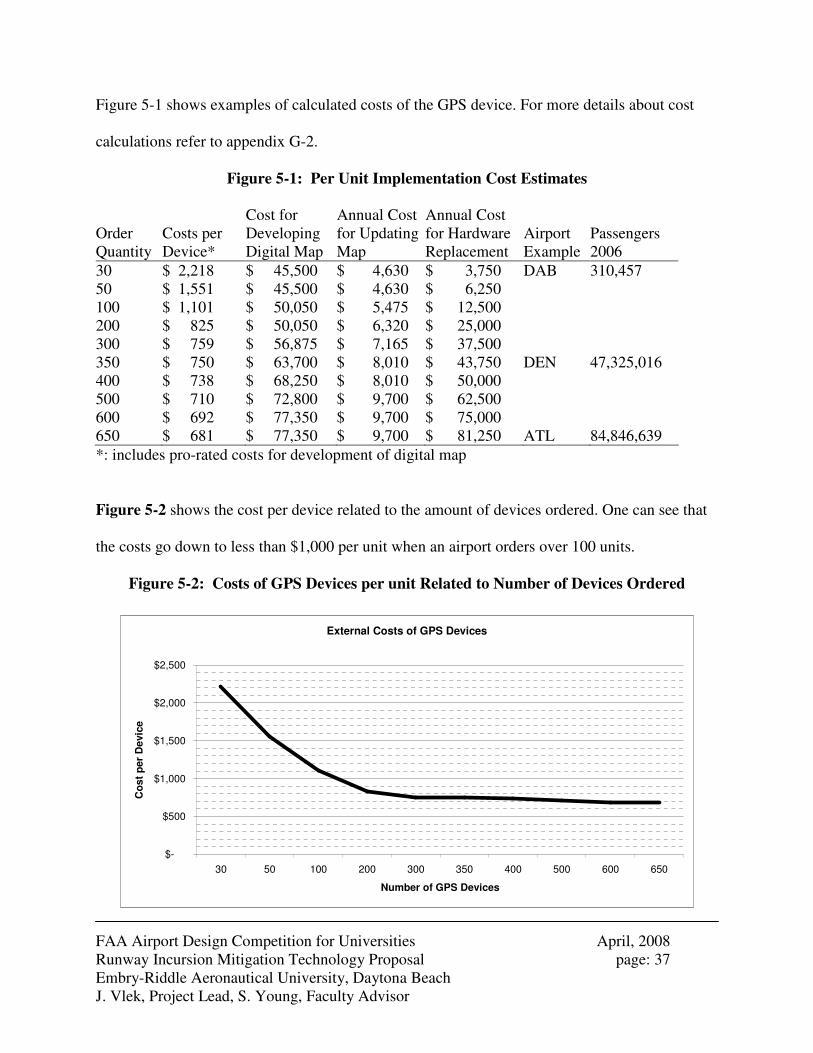
As part of this study, a cost implementation analysis was performed, using current estimates of
technology development, implementation, operation, and maintenance unit costs. In the
calculations for the cost per device were costs for the development of the digital map and the
required hardware. For smaller airports per unit implementation costs were estimated at
approximately $2,200. For bigger airports this cost goes down to about $700. The difference is
that the cost for development of the map is divided over more units than for smaller airports.
In comparison to ADS-B, which has been estimated to cost between $9,500 and $12,500 per
unit, the GPS device described in this report is about five times cheaper than ADS-B, and about
ten times FAA’s 2002 estimate of $20,000 per unit. For bigger airports the difference can get as
big as a factor of 17 for ADS-B and 25 to 30 times cheaper than FAA’s estimate.
The costs for the development of the map ranges from about $45,000 for airports with a simpler
layout to about $77,000 for airports with a more complex layout. The updating of the map will
cost between $5,000 and $10,000 annually. The replacement rate of the hardware is estimated at
25%
FAA Airport Design Competition for Universities April, 2008 Runway Incursion Mitigation Technology Proposal page: 37 Embry-Riddle Aeronautical University, Daytona Beach J. Vlek, Project Lead, S. Young, Faculty Advisor
Figure 5-1 shows examples of calculated costs of the GPS device. For more details about cost
calculations refer to appendix G-2.
Figure 5-1: Per Unit Implementation Cost Estimates
Order Quantity
Costs per Device*
Cost for Developing Digital Map
Annual Cost for Updating Map
Annual Cost for Hardware Replacement
Airport Example
Passengers 2006
30 $ 2,218 $ 45,500 $ 4,630 $ 3,750 DAB 310,457 50 $ 1,551 $ 45,500 $ 4,630 $ 6,250 100 $ 1,101 $ 50,050 $ 5,475 $ 12,500 200 $ 825 $ 50,050 $ 6,320 $ 25,000 300 $ 759 $ 56,875 $ 7,165 $ 37,500 350 $ 750 $ 63,700 $ 8,010 $ 43,750 DEN 47,325,016 400 $ 738 $ 68,250 $ 8,010 $ 50,000 500 $ 710 $ 72,800 $ 9,700 $ 62,500 600 $ 692 $ 77,350 $ 9,700 $ 75,000 650 $ 681 $ 77,350 $ 9,700 $ 81,250 ATL 84,846,639
*: includes pro-rated costs for development of digital map
Figure 5-2 shows the cost per device related to the amount of devices ordered. One can see that
the costs go down to less than $1,000 per unit when an airport orders over 100 units.
Figure 5-2: Costs of GPS Devices per unit Related to Number of Devices Ordered
External Costs of GPS Devices
$-
$500
$1,000
$1,500
$2,000
$2,500
30 50 100 200 300 350 400 500 600 650
Number of GPS Devices
Co
st
per D
evic
e
FAA Airport Design Competition for Universities April, 2008 Runway Incursion Mitigation Technology Proposal page: 38 Embry-Riddle Aeronautical University, Daytona Beach J. Vlek, Project Lead, S. Young, Faculty Advisor
The project costs only reflect the external costs. The airport has costs to incorporate it in their
Airport Certification Manual (ACM) and the FAA might want to evaluate the system as well.
Most of the additional costs for airports are cost for training and their project manager for the
system. Parts of these costs are already incurred, because this person usually works at the airport
already and just gets an extra task. Bigger airports might require a full-time employee designated
to maintaining and updating the system.
6. Summary and Conclusions
The research presented in this report identified an important yet underemphasized segment of
runway incursions, those caused by ground service vehicles. The technology described in this
report is an application of currently off-the-shelf GPS moving map hardware, enhanced with
software enhancements that identify airfield infrastructure and provide various visual and aural
warnings to vehicle drivers. The proposed GPS device is hypothesized to improve the situational
awareness of vehicle drivers at the airside of airports even in low visibility conditions. Compared
to most other mitigations against runway incursions this technology is found to be a relatively
inexpensive measure to achieve a lower runway incursion rate.
It is proposed that airside vehicles that regularly cross active areas be equipped with this device.
Such vehicles may include ARFF vehicles, airport security vehicles, tugs, buses, snow removal
FAA Airport Design Competition for Universities April, 2008 Runway Incursion Mitigation Technology Proposal page: 39 Embry-Riddle Aeronautical University, Daytona Beach J. Vlek, Project Lead, S. Young, Faculty Advisor
vehicles, de-icing trucks, or whichever other vehicle that airports or airlines feel it should be
equipped.
Testing of the proposed technology in an active airfield environment and feedback from industry
and academic experts revealed positive responses to the technology, other areas where such
technology may be useful, and provided feedback as to minimizing any associated risk with
implementing the technology. It is the opinion of the research team that this technology may be
indeed a beneficial and affordable strategy to minimizing runway incursions.
Further research suggests performing a two-year pilot technology implementation project at an
airport that has a high rate of V/PDs, such as Chicago O’Hare Field, Atlanta Hartsfield-Jackson
International Airport, or Philadelphia International Airport, the airports at which a change in
frequency of V/PDs will be most visible. Figure 6-1 illustrates a hypothetical schedule for such a
pilot project.
Figure 6-1: Potential Schedule for Pilot Project
FAA Airport Design Competition for Universities April, 2008 Runway Incursion Mitigation Technology Proposal page: 40 Embry-Riddle Aeronautical University, Daytona Beach J. Vlek, Project Lead, S. Young, Faculty Advisor
Pilot project budget requirements would include airfield database software development,
required hardware implementation, training, testing and evaluations, as well as for FAA and
airport participation. A detailed budget estimated is presented in appendix G-2.
The proposed satellite navigation technique is already widely in use in cars in cities and on
highways. This research has concluded that the GPS device technology would also a cost
effective way to reduce vehicle/pedestrian deviations. As it takes advantage of increasingly
accurate and increasingly less expensive technology, such a product would meet both the goals
of the FAA to improve airfield safety at increasingly economical rates. It is hoped that those
evaluating this proposed technology share this view.
A-1
Appendix A: Contact Information
Faculty Advisor: Dr. Seth Young Associate Professor, College of Business Embry-Riddle Aeronautical University 600. S. Clyde Morris Blvd. Daytona Beach, FL 32114 Tel. (386) 226-6723 Fax. (386) 226-6696 e-mail: [email protected] Student Lead: Joost Vlek Embry-Riddle Aeronautical University Master of Business Administration P.O. Box 146210 Daytona Beach, FL 32114 Email : [email protected] [email protected] (permanent) Phone : (386) 405 – 0691 Student Co-Authors
Richard Felix Genge Andrew Wilhelm Embry-Riddle Aeronautical University Embry-Riddle Aeronautical University B.S. Business Administration B.S. Business Administration P.O. Box 144015 P.O. Box 146547 Daytona Beach, FL 32114 Daytona Beach, FL 32114 Email : [email protected] Email : [email protected] Phone : (386) 843 – 1109 Phone : (434) 665 – 4955 Other Student Participants, Embry-Riddle Aeronautical University
Brent Appy Master of Business Administration John Gagne B.S. Business Administration Kevin Miller B.S. Business Administration Abdrahim Mohamed B.S. Business Administration Kenneth Schartel B.S. Business Administration Andrew Sophinos B.S. Business Administration Alex Wechsler B.S. Business Administration
A-2
Appendix B: Description of University
Embry-Riddle Aeronautical University is the world’s oldest and largest university specializing in
aviation and aerospace. It is the only accredited, aviation-oriented university in the world.
Embry-Riddle is an independent, non-sectarian, not-for-profit, coeducational university serving
culturally diverse students seeking careers in aviation, aerospace, business, engineering, and
related fields.
The University offers more than 30 degree programs. These include undergraduate programs in
aeronautical science; aeronautical systems maintenance; aeronautics; aerospace electronics;
aerospace engineering; aerospace studies; air traffic management; applied meteorology; aviation
business administration; aviation environmental science; aviation maintenance science; aviation
management; civil engineering; engineering physics; global security and intelligence studies;
homeland security; human factors psychology; mechanical engineering; safety science; software
engineering; and space physics. Graduate programs are offered in aeronautics, aerospace
engineering, business administration, human factors and systems, safety science, software
engineering, and space science.
Embry-Riddle Aeronautical University is accredited by the Commission on Colleges of the
Southern Association of Colleges and Schools to award degrees at the associate’s, bachelor’s,
and master’s levels. The College of Business at Embry-Riddle Aeronautical University is
accredited by the Associated of Collegiate Business Schools and Programs (ACBSP).
A-3
In fiscal year 2006-2007, some 171 faculty members were involved in research and other
activities with 151 sponsored projects. The total value of all active awards was more than $27
million.
This project was conducted within the university’s Airport Management Club, an organization
sanctioned by the Embry-Riddle Aeronautical University Office of Student Affairs. The Airport
Management Club is also sanctioned as official university student chapters of the American
Association of Airport Executives and the Florida Airports Council.
A-4
Appendix C: Description of non-university partners
No non-university entities acted as official partners on this project. However, a number of
external entities were consulted during the project. These entities include:
• Atlanta Hartsfield-Jackson International Airport
• Daytona Beach International Airport
• Denver International Airport
• FAA Office of Airports
• FAA Office of Runway Safety
• Tele Atlas
A-5
Appendix D: Design Proposal Submission Form
FAA University Design Competition
Design Proposal Submission Form (Appendix D)
Note: This form should be included as Appendix D in the submitted PDF of the design
package. The original with signatures must be sent along with the required print copy of
the proposal.
University Embry-Riddle Aeronautical University, Daytona Beach, Florida List other partnering universities if appropriate - NA - Proposal Developed by: Individual Student Student Team If Individual Student Name Permanent Mailing Address Permanent Phone Number Email If Student Team: Student Team Lead _____Joost Vlek Permanent Mailing Address PO BOX 146210, Embry Riddle Aeronautical University Daytona Beach, FL 32114__________ Permanent Phone Number (386) 405- 0961 Email [email protected] Competition Design Challenge Addressed: Runway Safety / Runway Incursions____________________ I certify that I served as the Faculty Advisor for the work presented in this Design Proposal and that the work was done by the student participant(s). Signed Date 4/15/2008
Name Seth Young University/College Embry-Riddle Aeronautical University, College of Business Department(s) Dept. of Management, Marketing, & Operations Street Address 600 S. Clyde Morris Blvd. City Daytona Beach State Florida Zip Code 32114 Telephone (386) 226-6723 Fax (386) 226 - 6696
A-6
Appendix E: Evaluation of Educational Experience
Students
Joost Vlek
The design competition provided me with a meaningful learning experience with regard to
runway incursions and GPS in particularly, topics that I knew the basics of, but not the very
details. It further was a great opportunity to train my presentation skills, as we presented our idea
at least five times internally or externally. It also introduced me to human factors. It was great to
work in a team with ten participants with different nationalities of the Airport Management Club.
I already knew a lot about airside operations as I have worked seven years internationally as an
Airport Civil Engineer at a major airport consultant from Europe. For some projects I had to
drive around on airsides, like for airside projects at Amsterdam Airport Schiphol (AMS), so I
knew about the importance of preventing runway incursions beforehand.
Our biggest challenge was to figure out how the device works. We contacted Tele Atlas. This
appeared to be helpful.
The idea of the GPS device arose out of brainstorming. We came up with a solution, and
hypothesized whether or not this device would be helpful to reduce the number of runway
incursions. We were surprised that it is not around yet. We were afraid that airports would not
like our idea, so when we presented our solution to the Daytona Beach International Airport and
A-7
the Denver International Airport, we were surprised about the positive feedback. We think that
we had a different approach to solutions to runway incursions, as many other solutions do not
focus on V/PDs. This is due to our ‘reverse approach’ of coming up with a solution and
investigating if it would work, rather than investigating what causes most runway incursions and
then finding a solution for that.
Contact with the industry has been helpful, because the airports made us feel that we are on the
right track and Tele Atlas gave us feedback on our questions.
As written above, I learned more about in-depth about runway incursions, GPS, and I trained my
presentation skills. This knowledge is not particularly required to go back into the workforce, but
it is a good ‘nice to have’, especially if we would end up being a winning team, whereas
presentation skills are required. It has also been great to work with students and interact with the
industry and academia, people that I otherwise would not have known. In that way the project
was a networking experience. After submitting this report I will still do further study in how to
make one of these devices really operational.
Richard Gegne
This year’s FAA Design Competition has been a great experience for me. Taking on the
challenge with some of my peers of the Airport Management Club also was a rewarding
experience for me and broadened my knowledge about problems that arise at an airport during
daily operations. I believe the competition was also a great addition to my Airport Management
A-8
major here at Embry-Riddle Aeronautical University. Furthermore I am convinced that this
competition is an invaluable experience for me that will put me one step closer to becoming an
airport manager. My team and I noticed right away that runway incursions are one of the biggest
safety issues at airports. When we started thinking about the runway incursions we wanted to
look at the problem from a different angle. While other working groups have focused on
Operator Errors or Pilot Deviations, we put all our attention to Vehicle/Pedestrian Deviations
(V/PD) to further reduce the amount of runway incursions.
Our research included several interviews with airport professionals who gave me and the team a
great inside view of what problems actually arise at the airport that fall under the category of a
V/PD. However, we found it difficult to acquire data about V/PD’s from most of the airports we
have contacted, because not many airports are willing to talk about their occurrences with
Vehicle/Pedestrian Deviations. But in the end we made our way through several reports and
actually found airport professionals that had a great impact on the way our final product was
designed. Industry participation for the project was absolutely necessary because those are the
one that have to deal with the problem of runway incursion every day and their experience report
was extremely important to us.
The solution we came up with, I think can really increase the safety standards at airports and
increase situational awareness of airport and airline employees to reduce the amount of V/PDs.
During our research, I also increased my knowledge about other technologies that are already out
there until this date and systems that are currently under development. The knowledge I gained
during this project will definitely help me in the future when trying to go out in the workforce of
A-9
the aviation industry. Finally I have to give credit to my team. Everybody was highly motivated
when working on the project and I think did a great job in thinking outside the box.
Andrew Wilhelm
During my work on this project I learned some valuable information about the current air
transportation system. One of the key elements learned was how old some of the systems are that
are still in use today. Many of the systems, such as radar, have been around since WWII. After
looking at statistics on the high number of runway incursions, I realized that something needs to
be done to update many of these systems. As we have found through the research, there are new
technologies already in existence that could significantly reduce the number of incursions each
year. Our project looks at one of these new technologies. The GPS system, which is being
implemented in some areas of the air transportation system, is a valuable tool that can give very
precise information about where something is at, wither it is a plane or a ground vehicle, in
regards to other objects in a given area. In the words of Sir Francis Bacon, “Knowledge is
Power” and knowing where obstacles are in the air and on the ground is half the battle in the
prevention of serious incursions. I was especially pleased to work on this project due to the
simple fact that few others have looked at runway incursions dealing with ground vehicles and
pedestrians. Although only a small percentage of incursions involve vehicles and pedestrians,
preventing just one fatal crash would make this system more than worthwhile.
A-10
Faculty Advisor
Dr. Seth Young
As an Associate Professor in the College of Business at Embry-Riddle Aeronautical University,
and faculty advisor to the university’s student chapter of the American Association of Airport
Executives, I am fully aware of the multitude of obligations that our undergraduate and graduate
students must manage, and understand that devoting many hours to extracurricular projects takes
significant dedication. The participation of a core group of these students devoted to this
competition, given their other obligations was impressive, which stands as a testament to both
the enthusiasm and educational rewards they expected to, and did, receive. This project in
particular was performed entirely as an extracurricular activity, associated with the university’s
Airport Management Club. As such, those that participated received an educational experience
far beyond their normal classroom curricula.
Specifically, this competition gave the students the ability to actively research an important
airfield safety issue, brainstorm and develop a potential solution, and most importantly, refine the
solution through interactions with industry, government, and academic experts in the fields of
data analysis, airfield operations, economics, human factors, and information technology. This
was truly a multi-disciplinary activity. In addition, the students learned to manage a large-scale
project, by appropriately dividing tasks, and sticking to a tight schedule.
The learning experience seemed to appropriately match the level of education for those that
participated. Leading the project was a graduate student with greater levels of real-world
experience in large scale project management. Undergraduates who most actively participated in
A-11
this project were of junior or senior standing, with the education and confidence to perform
literature-based as well as empirical research. For all the students, the opportunity to present
project progress in a formal setting contributed to their oral and written presentation skills.
Perhaps the greatest challenge that students had to overcome was in the gathering of data,
ranging from publicly sensitive data associated with individually reported runway incursion
incidents, to proprietary GPS technology information. Numerous phone calls and e-mails
eventually led to success in gathering data, but did create issues associated with overall project
schedules, as gathering such data was a lengthy process.
This competition is certainly a valuable educational tool, and I do intend to continue encouraging
students to participate. It is unclear whether this competition would be appropriate for a formal
class project, as the time dedication to this competition may exceed the allotted time for a given
class coursework. As an extracurricular project, the challenge to find students who have the time
and dedication to follow through always exists, but when such students are found, the process
has been revealed to be very rewarding.
One suggestion for this competition would be to assign a liaison from either FAA or industry to
each project group. Such a liaison could be a helpful resource for information gathering, internal
brainstorming, and overall project development. Perhaps an advisory partnership between a
faculty member and an industry representative could serve as an enhancement to the current
format. As a faculty member, I am grateful to the FAA and the Virginia Space Grant
Consortium for the opportunity for our students to participate in such a worthy competition.
A-12
Appendix F: References
References
[1] Federal Aviation Administration. Fact Sheet. “FAA Adopts ICAO Definition for Runway
Incursions.” Retrieved January 20, 2008, from http://www.faa.gov/news/fact_sheets/news_story.cfm?newsId=9612
[2] Federal Aviation Administration. Runway Safety Report, September 2007. Retrieved
January 18, 2008, from http://www.faa.gov/runwaysafety/pdf/rireport06.pdf [3] Federal Aviation Administration. Runway Safety Data and Statistics. Retrieved February
5, 2008, from http://www2.faa.gov/runwaysafety/data/ri_tot.cfm [4] Federal Aviation Administration - Office of Runway Safety. (2002). Runway Safety
Blueprint 2002-2004, p. 5, A-5. Retrieved April 1, 2008, from http://www.faa.gov/runwaysafety/pdf/blueprint1.pdf
[5] Federal Aviation Administration - Office of Safety and Standards. (August 2007).
Reducing the Potential for Vehicle/Pedestrian Deviations (V/PD) and Runway Incursions. Retrieved February 12, 2008, from http://www.faa.gov/airports_airtraffic/airports/airport_safety/media/vpd_briefing. pdf
[6] NASA – Langley Research Center, Runway Incursion Prevention. Retrieved February 2,
2008, from www.nasa.gov/centers/langley/pdf/70866main_FS-2000-09-53-LaRC.pdf [7] Prinzel III, L.J. and Jones D.R. , NASA Langley Research Center; Cockpit Technology
for Prevention of General Aviation Runway Incursions. Retrieved February 2, 2008, from http://amelia.db.erau.edu/nasacds/200705Disc1/research/20070018290_2007018395.pdf
[8] Federal Aviation Administration. Fact Sheet. Retrieved February 2, 2008 from
www.faa.gov/.../enroute/surveillance_broadcast/program_office_news/media/Fact_Sheet_6-6-07_APA.pdf
[9] Beneigh, Ted, 2007, Communications, Navigation & Surveillance Systems. [10] FAA – Capstone Program. Retrieved February 10, 2008 from
http://www.faa.gov/about/office_org/headquarters_offices/arc/programs/capstone/media/Alaska%20Sep%20Standards%20Statement_Final_Rev1.pdf
[11] ADS-B Technologies, LLC. Retrieved February 10, 2008, from http://www.ads-b.com/
A-13
[12] Garmin, http://www8.garmin.com/aviation/Safe_Flight_21_v0.69a.pdf , Accessed February 2, 2008.
[13] Aircraft Technology Engineering & Maintenance – Farnbourgh 2006 Special, Runway
incursion prevention. Retrieved February 2, 2008, from http://www.aviationindustrygroup.com/index.cfm?format=1345
[14] Federal Aviation Administration. Advisory Circular AC 150/5340-1J - Standards for
Airport Markings. Retrieved February 12, 2008, from http://www.airweb.faa.gov/Regulatory_and_Guidance_Library/rgAdvisoryCircul ar.nsf/0/8852e94e6586fdd28625700300509565/$FILE/150-5340_1j.pdf
[15] Federal Aviation Administration - Office of System Safety. (not dated). Airport Ground
Vehicle Operations, an FAA Guide. Retrieved February 6, 2008, from http://www.faa.gov/runwaysafety/asw/downloads/AGVO-guide.doc
[16] Ackerman, Holly R., Sept. 2007, FAA, Industry Set Runway Safety Plan, Airport Report.
Retrieved February 2, 2008, from http://www.aaae.org/fs03/Airport_Reports/9-1-07.pdf
[17] Betz, J. W., et al. (2006). Understanding GPS, Principles and Applications (Second Edition). In (E. D. Kaplan & C. J. Hegarty, Eds.). Norwood, MA: Artech House.
[18] El-Rabbany, A. (2006). Introduction to GPS, the Global Positioning System (Second Edition). Norwood, MA: Artech House.
[19] Vascellaro, J. E. (2007, January 17). Gadgets: Social networking gets easier by
cellphone; More companies add GPS services to track friends and family. The Wall Street
Journal Europe, p. 31. [20] Vascellaro, J. E. (2007, July 17). Business Technology: Sprint to Offer Loopt's 'Friend
Finding' Service. Wall Street Journal. (Eastern edition), p. B4. [21] Federal Aviation Administration. Advisory Circular 150/5200-37 - Introduction to Safety
Management Systems for Airport Operators. Retrieved February 12, 2008, from http://www.faa.gov/airports_airtraffic/airports/resources/advisory_circulars/med ia/150-5200-37/150_5200_37.pdf
[22] Burnett, G. E. “Turn right at the traffic lights” The requirement for landmarks in. The
Journal of Navigation, 53(3), 499-510. Retrieved April 5, 2008, from http://www.cs.nott.ac.uk/%7Egeb/Jnl%20nav-LM%20paper.pdf
A-14
Other Sources
"Airport Runway Crashes and Near-Misses Can Be Reduced with ARIPS." Norris Electro Optical Systems Corp. 7 Sept. 2008. Retrieved February 12, 2008 from http://www.norriseo.com/ Federal Aviation Administration. (May 21, 2004). Federal Aviation Administration Safety
Management System Manual. Retrieved March 24, 2008, from http://platinum.ts.odu.edu/Apps/FAAUDCA.nsf/FAA_SMS_Manual-Version_1_1. pdf Federal Aviation administration. Fact Sheet. March 23, 2007. “Increasing Runway Safety With GPS Aircraft Positioning”. Retrieved February 7, 2008, from http://www.faa.gov/news/fact_sheets/news_story.cfm?newsId=8409
Federal Aviation Administration. (March 31, 2008). Advisory Circular 150/5210-20 – Ground
vehicle Operations on Airports. Retrieved February 12, 2008, from http://www.faa.gov/airports_airtraffic/airports/resources/advisory_circulars/media/150-5210-20/150_5210_20_chg1.pdf Green, P. "paper presented at the Automotive Land Navigation Conference, June 18, 1997." Potential Safety Impacts of Automotive Navigation Systems. Retrieved March 21, 2008, from http://www.umich.edu/%7Edriving/publications/ALNC-Green1997.pdf "Runway Incursion Prevention - Cockpit Displays Could Help Reduce Accidents." National Aeronautics and Space Administration. Sept. 2000. Langley Research Center. Retrieved February 12, 2008 from http://www.nasa.gov/centers/langley/news/factsheets/RIPS.html Sharma, A. (2008, January 14). Who Keeps Digital Maps Going in Right Direction? Wall Street
Journal, p. B1. Strayer, D. L. & Drews, F. A. Cell-Phone–Induced Driver Distraction. Retrieved March 21, 2008, from http://www.psych.utah.edu/AppliedCognitionLab/cdir.pdf Strayer, D. L., Drews, F. A., Albert, R. W. & Johnstob, W. A. “Why do Cell Phone Conversations Interfere with Driving?” Retrieved April 12, 2008, from http://www.psych.utah.edu/AppliedCognitionLab/TRB1.pdf
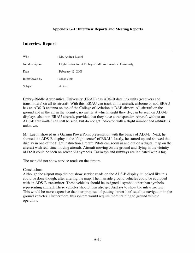
A-15
Appendix G-1: Interview Reports and Meeting Reports
Interview Report Who : Mr. Andrea Luethi Job description : Flight Instructor at Embry-Riddle Aeronautical University Date : February 13, 2008 Interviewed by : Joost Vlek Subject : ADS-B
Embry-Riddle Aeronautical University (ERAU) has ADS-B data link units (receivers and transmitters) on all its aircraft. With this, ERAU can track all its aircraft, airborne or not. ERAU has an ADS-B antenna on top of the College of Aviation at DAB airport. All aircraft on the ground and in the air in the vicinity, no matter at which height they fly, can be seen on ADS-B displays, also non-ERAU aircraft, provided that they have a transponder. Aircraft without an ADS-B transmitter can still be seen, but do not get indicated with a flight number and altitude is unknown. Mr. Luethi showed us a Garmin PowerPoint presentation with the basics of ADS-B. Next, he showed the ADS-B display at the ‘flight center’ of ERAU. Lastly, he started up and showed the display in one of the flight instruction aircraft. Pilots can zoom in and out on a digital map on the aircraft with real-time moving aircraft. Aircraft moving on the ground and flying in the vicinity of DAB could be seen on screen via symbols. Taxiways and runways are indicated with a tag. The map did not show service roads on the airport. Conclusion:
Although the airport map did not show service roads on the ADS-B display, it looked like this could be done though, after altering the map. Then, airside ground vehicles could be equipped with an ADS-B transmitter. These vehicles should be assigned a symbol other than symbols representing aircraft. These vehicles should then also get displays to show the infrastructure. This would be more expensive than our proposal of putting ‘street-like’ satellite navigation in the ground vehicles. Furthermore, this system would require more training to ground vehicle operators.
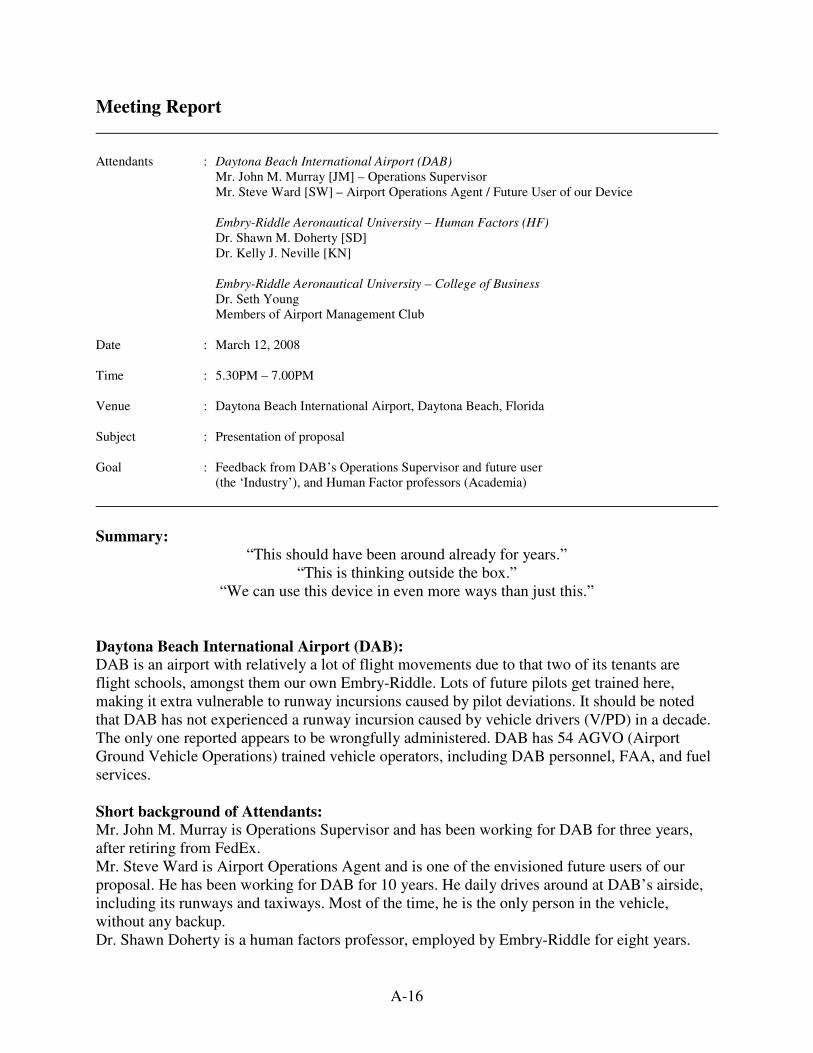
A-16
Meeting Report Attendants : Daytona Beach International Airport (DAB) Mr. John M. Murray [JM] – Operations Supervisor
Mr. Steve Ward [SW] – Airport Operations Agent / Future User of our Device Embry-Riddle Aeronautical University – Human Factors (HF)
Dr. Shawn M. Doherty [SD] Dr. Kelly J. Neville [KN] Embry-Riddle Aeronautical University – College of Business
Dr. Seth Young Members of Airport Management Club Date : March 12, 2008 Time : 5.30PM – 7.00PM Venue : Daytona Beach International Airport, Daytona Beach, Florida Subject : Presentation of proposal Goal : Feedback from DAB’s Operations Supervisor and future user (the ‘Industry’), and Human Factor professors (Academia)
Summary:
“This should have been around already for years.” “This is thinking outside the box.”
“We can use this device in even more ways than just this.”
Daytona Beach International Airport (DAB):
DAB is an airport with relatively a lot of flight movements due to that two of its tenants are flight schools, amongst them our own Embry-Riddle. Lots of future pilots get trained here, making it extra vulnerable to runway incursions caused by pilot deviations. It should be noted that DAB has not experienced a runway incursion caused by vehicle drivers (V/PD) in a decade. The only one reported appears to be wrongfully administered. DAB has 54 AGVO (Airport Ground Vehicle Operations) trained vehicle operators, including DAB personnel, FAA, and fuel services. Short background of Attendants:
Mr. John M. Murray is Operations Supervisor and has been working for DAB for three years, after retiring from FedEx. Mr. Steve Ward is Airport Operations Agent and is one of the envisioned future users of our proposal. He has been working for DAB for 10 years. He daily drives around at DAB’s airside, including its runways and taxiways. Most of the time, he is the only person in the vehicle, without any backup. Dr. Shawn Doherty is a human factors professor, employed by Embry-Riddle for eight years.
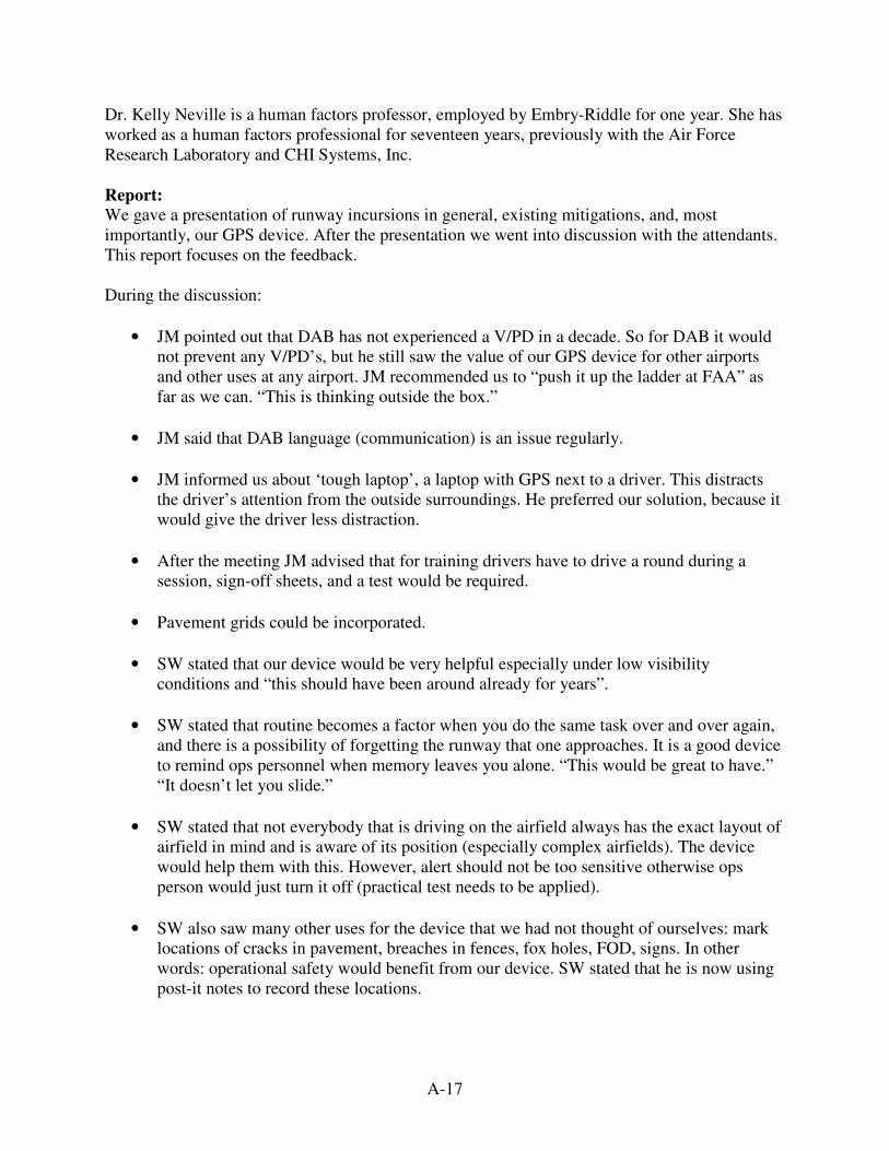
A-17
Dr. Kelly Neville is a human factors professor, employed by Embry-Riddle for one year. She has worked as a human factors professional for seventeen years, previously with the Air Force Research Laboratory and CHI Systems, Inc. Report:
We gave a presentation of runway incursions in general, existing mitigations, and, most importantly, our GPS device. After the presentation we went into discussion with the attendants. This report focuses on the feedback. During the discussion:
• JM pointed out that DAB has not experienced a V/PD in a decade. So for DAB it would not prevent any V/PD’s, but he still saw the value of our GPS device for other airports and other uses at any airport. JM recommended us to “push it up the ladder at FAA” as far as we can. “This is thinking outside the box.”
• JM said that DAB language (communication) is an issue regularly.
• JM informed us about ‘tough laptop’, a laptop with GPS next to a driver. This distracts the driver’s attention from the outside surroundings. He preferred our solution, because it would give the driver less distraction.
• After the meeting JM advised that for training drivers have to drive a round during a session, sign-off sheets, and a test would be required.
• Pavement grids could be incorporated.
• SW stated that our device would be very helpful especially under low visibility conditions and “this should have been around already for years”.
• SW stated that routine becomes a factor when you do the same task over and over again, and there is a possibility of forgetting the runway that one approaches. It is a good device to remind ops personnel when memory leaves you alone. “This would be great to have.” “It doesn’t let you slide.”
• SW stated that not everybody that is driving on the airfield always has the exact layout of airfield in mind and is aware of its position (especially complex airfields). The device would help them with this. However, alert should not be too sensitive otherwise ops person would just turn it off (practical test needs to be applied).
• SW also saw many other uses for the device that we had not thought of ourselves: mark locations of cracks in pavement, breaches in fences, fox holes, FOD, signs. In other words: operational safety would benefit from our device. SW stated that he is now using post-it notes to record these locations.
A-18
• SW stated that the voice warnings should be definitely incorporated in the device. The device should take driving speed into account so that warnings come in a timeliness way allowing the driver to take corrective action when necessary.
• It was noted that runway incursions that are about to happen, but that don’t happen because of corrective actions, are not recorded. So the device might be more helpful than statistics will indicate.
• SD advised us to address the following in our report: o Distraction of the driver by the device o Location of the device in the car o The device would be useful in low visibility, but would the costs be worth it in
good visibility? What impacts would it have in good visibility. Explain why it is better than a paper map.
o Are the costs worth it, considering the device addresses only a minority of the runway incursions?
o Why do we think it improves situational awareness? Maybe it makes situational awareness worse by distraction.
• KN stressed that updates of the moving maps are to be very accurate. Inaccurate maps (where an update wasn’t made or wasn't accurate) would be a source of communication breakdown between the technology and users. Users would expect the maps to be accurate and if the technology does not warn of the possibility of inaccuracy (i.e., technology does not communicate key info to the user), then you have a communication breakdown and serious mistakes may be made.
• KN advised us to try to find unexpected consequences coming along with our device.
• KN advised us to look for a real case of a V/PD that has happened and that could have been prevented by our device. This would build our case. Or use one of Steve's close-call scenarios. Steve’s recollection of a close-call would be just as convincing as an actual V/PD and would be richer in terms of the amount of detail. Further, he could tell you what might have been different if he had the GPS device you are proposing. Expertise is invaluable for many reasons, including when it comes to really understanding the constraints and opportunities of your problem space and evaluating your candidate solutions. Steve is an amazing resource.
• KN advised us to look into literature about the relationship of car accidents and the use of GPS devices.
Other comments from a human factors perspective:
• Where are possibilities of communication breakdowns between humans and technology?
• What is the systems reaction in emergency situations? There is a tendency to focus on the typical-use scenarios when designing systems. What happens in an emergency or atypical scenario? Is the GPS device still supportive and
A-19
useful and can it be made more so? Or does it add to the chaos because it is easily misinterpreted or misused by a panicked person? Are new communication breakdown risks revealed?
Other comments:
• Explain relationship between new ICAO definition of runway incursion and increase in registered runway incursions since ICAO’s definition has been adopted.
Concerns:
1. Distraction 2. ‘Blaming the device’ 3. Keep the maps accurate and updated

A-20
Field Test Attendants : Daytona Beach International Airport (DAB) Mr. Steve Ward – Airport Operations Agent / Future User of our Device Embry-Riddle Aeronautical University
Joost Vlek Date : April 2, 2008 Time : 8.30AM – 10.00AM Venue : Daytona Beach International Airport, Daytona Beach, Florida Subject : Field test with Garmin road GPS device on DAB’s airside Goal : Address concerns raised at the presentation held on March 12, 2008 at DAB
Introduction:
One of our team members has a road GPS device. While driving near DAB we noticed that the runways and taxiways are on its moving map, except for their designation. After the presentation of our proposal at DAB, John Murray, the airport’s Operations Supervisor, suggested that we take the device out and drive around on airside. This way we could not only see if the map is accurate, but also if the concerns raised at the presentation could indeed be observed and if there are other issues that might show up. Field Test:
The visibility was good with clear skies. We placed the GPS device in the middle of the dashboard of the airport’s pickup truck and started driving on the airside for inspections. After the device had been started up and satellite reception was acquired we headed for the apron towards the taxiways. On all taxiways that we drove on, the map showed our position accurately. However, the map did not show us on the centerline of some taxiways. The accuracy can be stressed by that the speed indicated on the device was always matching the speed on the vehicle’s speedometer, even when slowing down or speeding up. This was already observed when the authors took it for a test ride on the roads. This indicates that the position of the car gets checked very frequently, at least multiple times per second, a must for our device. DAB’s service roads are not on the map. When we were driving on the service roads it showed us driving through green areas, indicating grassed areas. In this case the device did not assume that we were on a nearby road or taxiway. During an earlier road test we discovered that when we drove on a close parallel road that was not on the map, the device assumed we were on the other road. After a couple of seconds it showed our position wrongfully on the other road. This cannot be tolerated with our device. During our test drive there was a problem with a landing gear of an aircraft on approach, causing three ARFF vehicles and an airport operations vehicle to come out to the runway. During this event, the device had not caused any distractions to Mr. Ward.
A-21
Concerns:
The concerns raised at the meeting were: 1. Distraction 2. ‘Blaming the device’ 3. Keep the maps accurate and updated
Outcome:
1. Distraction
After witnessing the nose gear incident we could carefully go into the direction of concluding that the device does not cause distraction. It might help that airside layouts are more open than more closely constructed landside infrastructure.
2. ‘Blaming the device’
This concern could not be witnessed. This might occur only after the driver was involved in an incident, which we were not.
3. Keep the maps accurate and updated This can not be witnessed with a test drive like this. This is a matter of accuracy and attention with the airport operator when infrastructural projects take place.
Other:
We inquired John Murray, Operations Supervisor at DAB, on how many vehicles would probably be equipped by our device. DAB has 54 trained AGVO drivers. They operate 25 to 30 vehicles that drive on movement areas. This number includes airport operations’ surveillance vehicles, fuel trucks, and five ARFF vehicles. The movement areas are defined as the runways and taxiways. The aprons are considered as non-movement area. At any one time there would be about ten vehicles in active areas. It would not be appropriate to have only ten devices at the airport, because this leads to that people have to get them from other cars when they drive another vehicle. People are lazy by nature and in order to avoid that people go out without a device, all the 25 to 30 vehicles should be equipped with our device, also because they are to be mounted to the vehicle to prevent theft, making it difficult to get them out and place in another vehicle.
A-22
Meeting Report Who : Mr. Jason Taussig [JT] Job description : Agency Trainer – Denver International Airport (DEN) Date : April 4, 2008 Attendants : Jason Taussig, Richard Genge, Joost Vlek Subject : Runway Incursions; GPS Device
One of Mr. Jason Taussig’s duties at DEN is to coordinate programs to train vehicle operators. He visited Embry-Riddle Aeronautical University. He is an Embry-Riddle alumnus. He showed us a PowerPoint presentation about runway incursions at DEN. We showed him our device.
• JT informed us that DEN has had seven runway incursions in the period between December 2006 and February 2008 that had not been caught by FAA. Six of the V/PDs were a vehicle deviation and one was an operational error.
• JT that for vehicles that are crossing taxiways and runways our device would be helpful; certainly for snow vehicles and operations vehicle and in conditions where the runway visual range (RVR) is less than 600 feet.
City of Denver has the following vehicles active on airside:
• Operations, Fire, and Maintenance for about 350 vehicles
• JT stated that FCC currently has issues with transponders (to locate vehicles) in vehicles, because transponders are designed for aircraft. Our device would be a great alternative. Currently FCC and FAA working out an agreement to allow transponders in vehicles for ASDE X. Additional costs will be added to have interface with vehicle operators.
Human Factors:
1. How will it impact the driver that is already listening to three or four radios? 2. How to catch people that do not report, or that have the wrong attitude? 3. Should the device record time and location? If yes, how to protect the data for the
aviation industry, so that it can be handled in an open manner (to make aviation safer) instead that people will want to destroy the data?
A-23
Contact Report Contacted : Hartsfield-Jackson Atlanta International Airport / Federal Aviation Administration Contactor : Joost Vlek Contact Media : Phone, Email Date : Spring 2008 Subject : V/PD Database
We contacted Hartsfield-Jackson Atlanta International Airport (ATL) for requesting their FAA forms 8020-25 “Investigation of V/PD Report” and forms 8020-24 “Preliminary V/PD Deviation Report”, to be able to better understand the circumstances that are involved in a runway incursion. ATL did not want to share these forms with us, because the documents contain names of those involved. We then tried to obtain the forms from the FAA. Also at FAA, people were hesitant first and did not know if they were permitted to share these forms. We had contact with the following FAA employees:
1. Linda Berkowitz (FAA) – Lead Airport Certification Safety Inspector, Airports Division, Southern Region, who forwarded us to
2. Anna Collin (FAA), who forwarded us to 3. David Webb (FAA) from Washington Runway Safety Office, who forwarded us to 4. Theresa Payne (FAA), who got 5. Michael Vendetti (FAA) to send us a V/PD database with thousands of cases.
In the end we did not have the requested forms, but we had a database with thousands of individual cases and their circumstances, basically giving the information that we wanted.
A-24
Contact Report Contacted : Tele Atlas, Mr. Donald Cooke Contactor : Joost Vlek Contact Media : Email Date : March 6, 2008 & March 25, 2008 Subject : Moving Maps, Geo Fencing, Mapping Software
“I think you have two challenges: one is to make a digital map of the runway or simulated runway, and the other is to find software which can manipulate and display the map and display real-time GPS readings…” Mr. Cooke recommended us to use ESRI GIS software. “It's not free but should be affordable to the University. ESRI has systems that will do everything you would need to do both in adjusting and aligning the maps and implementing the in-vehicle display. You may find that some of their users have already implemented similar systems -- it's basically a "geofencing" application.”
A-25
Contact Report Contacted : American International Group, Inc. AIG Carson Lyons Contactor : Joost Vlek Contact Media : In person Date : Spring 2008 Semester Subject : Insurance
We briefly spoke to Mr. Lyons when he was on campus. He could not tell us whether or not insurance premiums would go down (because chance on a runway incursion potentially goes down) when ground vehicles would be equipped with our device. If insurance premiums would go down, this would lead to less insurance expense and to more savings, reducing the cost of projects involving GPS devices in ground vehicles at airports.
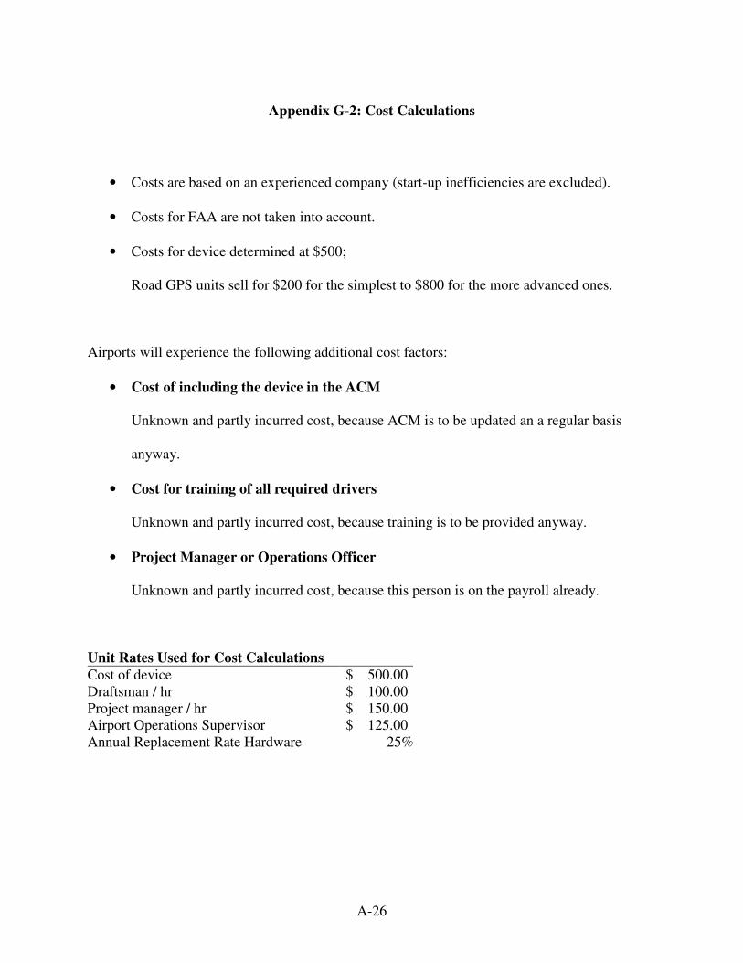
A-26
Appendix G-2: Cost Calculations
• Costs are based on an experienced company (start-up inefficiencies are excluded).
• Costs for FAA are not taken into account.
• Costs for device determined at $500;
Road GPS units sell for $200 for the simplest to $800 for the more advanced ones.
Airports will experience the following additional cost factors:
• Cost of including the device in the ACM
Unknown and partly incurred cost, because ACM is to be updated an a regular basis
anyway.
• Cost for training of all required drivers
Unknown and partly incurred cost, because training is to be provided anyway.
• Project Manager or Operations Officer
Unknown and partly incurred cost, because this person is on the payroll already.
Unit Rates Used for Cost Calculations
Cost of device $ 500.00 Draftsman / hr $ 100.00 Project manager / hr $ 150.00 Airport Operations Supervisor $ 125.00 Annual Replacement Rate Hardware 25%
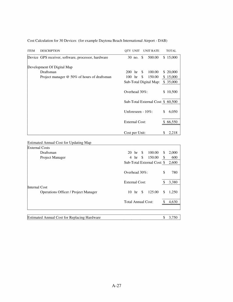
A-27
Cost Calculation for 30 Devices (for example Daytona Beach International Airport - DAB)
ITEM DESCRIPTION QTY UNIT UNIT RATE TOTAL
Device GPS receiver, software, processor, hardware 30 no. $ 500.00 $ 15,000
Development Of Digital Map
Draftsman 200 hr $ 100.00 $ 20,000
Project manager @ 50% of hours of draftsman 100 hr $ 150.00 $ 15,000
Sub-Total Digital Map: $ 35,000
Overhead 30%: $ 10,500
Sub-Total External Cost: $ 60,500
Unforeseen - 10%: $ 6,050
External Cost: $ 66,550
Cost per Unit: $ 2,218
Estimated Annual Cost for Updating Map
External Costs
Draftsman 20 hr $ 100.00 $ 2,000
Project Manager 4 hr $ 150.00 $ 600
Sub-Total External Cost: $ 2,600
Overhead 30%: $ 780
External Cost: $ 3,380
Internal Cost
Operations Officer / Project Manager 10 hr $ 125.00 $ 1,250
Total Annual Cost: $ 4,630
Estimated Annual Cost for Replacing Hardware $ 3,750
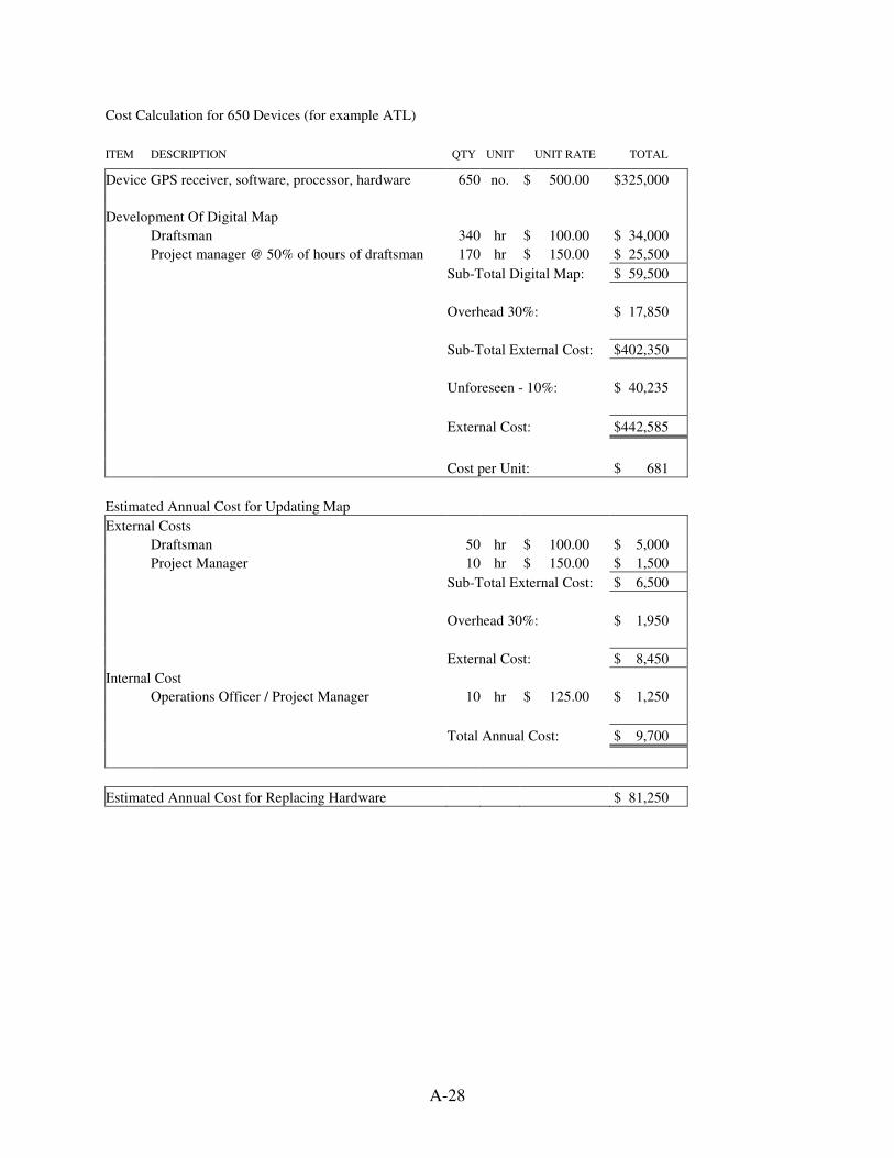
A-28
Cost Calculation for 650 Devices (for example ATL)
ITEM DESCRIPTION QTY UNIT UNIT RATE TOTAL
Device GPS receiver, software, processor, hardware 650 no. $ 500.00 $325,000
Development Of Digital Map
Draftsman 340 hr $ 100.00 $ 34,000
Project manager @ 50% of hours of draftsman 170 hr $ 150.00 $ 25,500
Sub-Total Digital Map: $ 59,500
Overhead 30%: $ 17,850
Sub-Total External Cost: $402,350
Unforeseen - 10%: $ 40,235
External Cost: $442,585
Cost per Unit: $ 681
Estimated Annual Cost for Updating Map
External Costs
Draftsman 50 hr $ 100.00 $ 5,000
Project Manager 10 hr $ 150.00 $ 1,500
Sub-Total External Cost: $ 6,500
Overhead 30%: $ 1,950
External Cost: $ 8,450
Internal Cost
Operations Officer / Project Manager 10 hr $ 125.00 $ 1,250
Total Annual Cost: $ 9,700
Estimated Annual Cost for Replacing Hardware $ 81,250