application for approval and … 2...application for approval and certification of electrical...
TRANSCRIPT
APPALACHIAN POWER COMPANY BEFORE THE
VIRGINIA STATE CORPORATION COMMISSION CASE NO. PUE-2015-00021
APPLICATION FOR APPROVAL AND CERTIFICATION OF ELECTRICAL TRANSMISSION LINE
Tazewell-Bearwallow 138 kV Transmission Line Rebuild Project
VOLUME 2 OF 2
VDEQ Supplement
March, 2015

Tazewell-Bearwallow 138 kV CONTENTS Transmission Line Rebuild Project
i
VOLUME 1 - Application, Testimony, & Response to Guidelines
LIST OF EXHIBITS & ATTACHMENTS ........................................................................................... ii
GLOSSARY OF TERMS & ABBREVIATIONS ............................................................................... iv
EXECUTIVE SUMMARY ................................................................................................................ vi
APPLICATION
TESTIMONY
Direct Testimony of Evan R. Wilcox, P.E. (Project Need)
Direct Testimony of Timothy B. Earhart, P.E. (Project Engineering)
Direct Testimony of Richard Gutman, P.E. (EMF)
Direct Testimony of William P. Johnsen, P.G. (Environmental)
RESPONSE TO GUIDELINES
Section I. Necessity for the Proposed Project
Section II. Description of the Proposed Project
Section III. Impact of Line on Scenic, Environmental, and Historic Features
Section IV. Health Aspects of EMF
Section V. Notice
EXHIBITS
VOLUME 2 - VDEQ Supplement
LIST OF EXHIBITS & ATTACHMENTS ........................................................................................... ii
VDEQ SUPPLEMENT
VDEQ SUPPLEMENT ATTACHMENTS

Tazewell-Bearwallow 138 kV LIST OF EXHIBITS & ATTACHMENTS Transmission Line Rebuild Project
ii
VOLUME 1
EXHIBITS EXHIBIT 1: GENERAL LOCATION MAP
EXHIBIT 2: PUBLIC NOTICE MAP
EXHIBIT 3: GENERAL HIGHWAY MAP & EXISTING TRANSMISSION FACILITIES
EXHIBIT 4: GIS CONSTRAINTS MAP SET (TOPOGRAPHIC BACKGROUND)
EXHIBIT 5: GIS CONSTRAINTS MAP SET (AERIAL PHOTO BACKGROUND)
EXHIBIT 6: PRESENT TRANSMISSION SYSTEM
EXHIBIT 7: EXISTING AND PROPOSED TRANSMISSION STRUCTURE COMPARISON
EXHIBIT 8: PROPOSED TRANSMISSION STRUCTURE: H-FRAME
EXHIBIT 9: PROPOSED TRANSMISSION STRUCTURE: 3-POLE
EXHIBIT 10: PROPOSED TRANSMISSION STRUCTURE: MONOPOLE (SINGLE CIRCUIT)
EXHIBIT 11: EXISTING CONTEXT PHOTOGRAPH SET
EXHIBIT 12: PROPOSED TAZEWELL SUBSTATION IMPROVEMENTS
EXHIBIT 13: PROPOSED BEARWALLOW SUBSTATION IMPROVEMENTS
VOLUME 2 VDEQ SUPPLEMENT ATTACHMENTS ATTACHMENT 1: GENERAL LOCATION MAP
ATTACHMENT 2: ENVIRONMENTAL FEATURES SUMMARY TABLE
ATTACHMENT 3: DESKTOP SURVEY OF WETLAND AND STREAM RESOURCES
ATTACHMENT 4: VIRGINIA MARINE RESOURCES COMMISSION CONSULTATION RESPONSE
ATTACHMENT 5: VIRGINIA DEPARTMENT OF ENVIRONMENTAL QUALITY – OFFICE OF
WETLANDS AND STREAM PROTECTION CONSULTATION RESPONSE
ATTACHMENT 6: VIRGINIA DEPARTMENT OF CONSERVATION AND RECREATION
CONSULTATION RESPONSE
ATTACHMENT 7: VIRGINIA DEPARTMENT OF GAME AND INLAND FISHERIES CONSULTATION
RESPONSE
ATTACHMENT 8: VIRGINIA FISH AND WILDLIFE INFORMATION SERVICE REVIEW
ATTACHMENT 9: U.S. FISH AND WILDLIFE SERVICE CONSULTATION CORRESPONDENCE
ATTACHMENT 10: PRE-APPLICATION ANALYSIS FOR CULTURAL RESOURCES OF THE
TAZEWELL-BUCHANAN 138 KV TRANSMISSION IMPROVEMENTS PROJECT
ATTACHMENT 11: VIRGINIA DEPARTMENT OF HISTORIC RESOURCES RESPONSE

Tazewell-Bearwallow 138 kV LIST OF EXHIBITS & ATTACHMENTS Transmission Line Rebuild Project
iii
ATTACHMENT 12: VIRGINIA DEPARTMENT OF AGRICULTURE AND CONSUMER SERVICES
CONSULTATION RESPONSE
ATTACHMENT 13: VIRGINIA OUTDOORS FOUNDATION CONSULTATION RESPONSE
ATTACHMENT 14: VIRGINIA DEPARTMENT OF FORESTRY CONSULTATION RESPONSE
ATTACHMENT 15: VIRGINIA NATURAL HERITAGE PROGRAM - KARST PROTECTION
COORDINATOR CONSULTATION RESPONSE
ATTACHMENT 16: VIRGINIA DEPARTMENT OF TRANSPORTATION CONSULTATION
RESPONSE

APPALACHIAN POWER COMPANY
Tazewell-Bearwallow 138 kV Transmission Line Rebuild Project
VDEQ Supplement
P r e p a r e d b y
F e b r u a r y 2 4 , 2 0 1 5

VDEQ Supplement Tazewell-Bearwallow 138 kV Transmission Line Rebuild Project
i
TABLE OF CONTENTS
1.0 PROJECT DESCRIPTION ................................................................................................ 2
2.0 ENVIRONMENTAL ANALYSIS ........................................................................................ 2
A. Air Quality .............................................................................................................. 3 B. Water Source ........................................................................................................ 3 C. Discharge of Cooling Waters ................................................................................. 4 D. Tidal and Non-Tidal Wetlands ............................................................................... 4 E. Solid and Hazardous Waste .................................................................................. 5 F. Natural Heritage, Threatened and Endangered Species....................................... 5 G. Erosion and Sediment Control .............................................................................. 7 H. Archaeological, Historic, Scenic, Cultural or Architectural Resources .................. 7 I. Chesapeake Bay Preservation Areas.................................................................... 8 J. Wildlife Resources ................................................................................................. 8 K. Recreation, Agricultural, and Forest Resources .................................................... 8 L. Use of Pesticides and Herbicides .......................................................................... 9 M. Geology and Mineral Resources ......................................................................... 10 N. Transportation Infrastructure ............................................................................... 10
3.0 REFERENCES ................................................................................................................ 10
ATTACHMENTS
1. General Location Map 2. Environmental Features Summary Table 3. Desktop Survey of Wetland and Stream Resources 4. Virginia Marine Resources Commission Consultation Response 5. Virginia Department of Environmental Quality – Office of Wetlands and Stream
Protection Consultation Response 6. Virginia Department of Conservation and Recreation Consultation Response 7. Virginia Department of Game and Inland Fisheries Consultation Response 8. Virginia Fish and Wildlife Information Service Review 9. U.S. Fish and Wildlife Service Consultation Correspondence 10. Pre-Application Analysis for Cultural Resources of the Tazewell-Buchanan 138 kV
Transmission Improvements Project 11. Virginia Department of Historic Resources Response 12. Virginia Department of Agriculture and Consumer Services Consultation Response 13. Virginia Outdoors Foundation Consultation Response 14. Virginia Department of Forestry Consultation Response 15. Virginia Natural Heritage Program- Karst Protection Coordinator Consultation
Response 16. Virginia Department of Transportation Consultation Response

VDEQ Supplement Tazewell-Bearwallow 138 kV Transmission Line Rebuild Project
ii
LIST OF ACRONYMS
AEP APCo BMPs E&S HUC kV NHL NRHP NRG NWP Project ROW SCU UNT USACE USEPA USFWS USGS VDACS VDCR VDEQ VDOF VDGIF VDOH VDHR VDOT VOF VMRC VWP
American Electric Power Company, Inc. Appalachian Power Company Best Management Practices Erosion and Sediment Hydrological Unit Code kilovolt National Historic Landmark National Register of Historic Places Natural Resource Group, LLC Nationwide Permit Tazewell-Bearwallow Area 138 kV Transmission Line Rebuild Project Right-of-way Stream Conservation Unit unnamed tributary U.S. Army Corps of Engineers U.S. Environmental Protection Agency U.S. Fish and Wildlife Service U.S. Geological Survey Virginia Department of Agriculture and Consumer Services Virginia Department of Conservation and Recreation Virginia Department of Environmental Quality Virginia Department of Forestry Virginia Department of Game and Inland Fisheries Virginia Department of Health Virginia Department of Historic Resources Virginia Department of Transportation Virginia Outdoors Foundation Virginia Marine Resources Commission Virginia Water Protection

VDEQ Supplement Tazewell-Bearwallow 138 kV Transmission Line Rebuild Project
1
Based on consultations with the Virginia Department of Environmental Quality (VDEQ), Appalachian Power Company (APCo) has developed this VDEQ Supplement to facilitate review and analysis of the proposed Project by VDEQ and other relevant agencies.
VDEQ Supplement Tazewell-Bearwallow 138 kV Transmission Line Rebuild Project
2
1.0 PROJECT DESCRIPTION
Appalachian Power Company (APCo), an affiliate of American Electric Power Company, Inc. (AEP), is proposing to construct the Tazewell-Bearwallow 138 kV Transmission Line Rebuild Project in Tazewell County, Virginia (the “Rebuild,” the Virginia portion thereof, the “Project”). The Rebuild is needed to ensure adequate and reliable electric service and to accommodate future growth in Tazewell County and Buchanan County, Virginia and McDowell County, West Virginia. A general location map depicting the portions of the Rebuild located within the Commonwealth of Virginia is included as Attachment 1. Additional mapping is also available in Volume 1 of this application as Exhibits 1 through 5.
The majority of the proposed transmission line in Virginia is proposed to be constructed on existing right-of-way (ROW). However, minor route adjustments (“reroutes”) to accommodate landowner requests and constructability/operational constraints have been incorporated into the proposed preliminary design of the Project, which would require deviation from the existing ROW in three locations (see Attachment 1). The reroutes amount to approximately 0.70 mile of the approximately 7.8 mile length of the proposed line in Virginia. The Rebuild would entail the following:
Rebuilding approximately 12.5 miles of an existing 69 kV transmission line to 138 kV, approximately 7.8 miles of which is located in Virginia and approximately 4.7 miles of which is located in West Virginia (the “Tazewell-Bearwallow 138 kV Transmission Line”).
Associated substation improvements at APCo’s existing Tazewell and Bearwallow Substations in Virginia and its existing Faraday Substation in West Virginia. These improvements include expanding the upper yard at the Tazewell Substation by approximately 2 acres from 0.7 acre to 2.7 acres.
In addition to the proposed substation and transmission line improvements, temporary material laydown yards and access roads for structure erection and conductor stringing are necessary. AEP has estimated that approximately 30 percent of the needed access roads already exist. The location and extent of access roads cannot be determined until after final line design and field reconnaissance has occurred. In any event, the required access roads will be located and built to minimize potentially adverse impacts on landowners and the environment.
2.0 ENVIRONMENTAL ANALYSIS
Natural Resource Group, LLC (NRG), on behalf of APCo, has conducted an analysis of environmental conditions on the Project. The analysis of environmental effect was conducted on the existing 60-foot ROW, as expanded to 100 feet, the new proposed 100-foot wide ROW at the three route adjustments which deviate from the existing ROW, and the approximate two acre footprint expansion of the upper yard at the Tazewell Substation.
This analysis will focus on the 7.8 mile Virginia portion of the 12.5 mile proposed line only. A separate environmental analysis was completed for the 4.7 mile West Virginia portion, and an application for authority to construct the West Virginia portion of the proposed line was approved by the Public Service Commission of West Virginia in Case No. 14-0905-E-CN on September 16, 2014. The findings with respect to the Virginia portion follow. A summary of the resources crossed by the Project is provided in Attachment 2.

VDEQ Supplement Tazewell-Bearwallow 138 kV Transmission Line Rebuild Project
3
A. Air Quality
The Project involves the construction of new structures along an existing 60-foot-wide ROW, to be expanded to 100 feet, as well as along new ROW. Tree and brush removal will be necessary along the new ROW and may be necessary along portions of the existing ROW as expanded. The footprint for the expanded upper yard at the Tazewell Substation is currently undeveloped grasslands and may require the removal of up to three trees.
APCo does not expect to burn cleared material but, if necessary, APCo will coordinate with the responsible locality to obtain permits and will comply with conditions set forth by the locality. APCo's ROW clearing methods are described in Section II.A.5. of the Response to Guidelines located in Volume 1 of this application. No air emissions will be produced by the new facilities. Therefore, the Project will not have either temporary or permanent effects on air quality.
B. Water Source
Since no water source is required for transmission lines, this discussion will focus on water bodies that will be crossed by the proposed transmission line. Wetlands are discussed in Section 2.D of this Supplement.
The Project is located within the Dry Fork (Hydrological Unit Code (HUC): 0507020101), and Indian Creek – Clinch River (HUC: 0601020501) watershed (USEPA, 2014a).
According to the Virginia Department of Conservation and Recreation’s (VDCR) Managed Lands dataset (VDCR, 2014), the Project does not cross public water supply reservoirs; however, the proposed Tazewell-Bearwallow 138 kV Transmission Line crosses several stream systems and their associated tributaries: According to the U.S. Geological Survey (USGS) National Hydrography Dataset (USGS, 2014), the Tazewell-Bearwallow Line crosses one unnamed tributary (UNT) to Vall Creek, four UNTs to Beech Fork, Beech Fork, Dry Fork (three crossings), Dick Creek (two crossings), two UNTs to Dick Creek, one UNT to Dry Fork, and three UNTs to Mundy Branch.
Waterbodies will be spanned by the electric transmission line and no structures will be placed within waterbodies. Clearing will be performed by hand within 50 feet of either side of a waterbody and low-growth shrubs and other compatible vegetation will be left undisturbed. APCo will avoid crossing these waterbodies with equipment, but if it becomes necessary, temporary culvert bridges will be used and installed in accordance with applicable rules and regulations. A summary of the wetlands and streams crossed by the Project is detailed in the Desktop Survey of Wetland and Stream Resources document, included as Attachment 3.
NRG initiated coordination with the Virginia Marine Resources Commission (VMRC) concerning the Project. The VMRC responded in an e-mail dated March 11, 2014 (Attachment 4), advising that the VMRC exerts jurisdiction over all state waters. Accordingly, if portions of the Project involves encroachments channelward of ordinary high water above the fall line, including aerial crossings, a permit may be required. A Joint Permit application to cross jurisdictional wetlands and waterbodies will be submitted to the VMRC, Virginia Department of Environmental Quality (VDEQ), and the U.S. Army Corps of Engineers (USACE).
VDEQ Supplement Tazewell-Bearwallow 138 kV Transmission Line Rebuild Project
4
NRG initiated coordination with the VDEQ Office of Wetlands & Stream Protection concerning the Project. The response from the VDEQ Office of Wetlands & Stream Protection, dated March 27, 2014 (Attachment 5), recommended that wetland and stream crossings be field delineated prior to detailed engineering, clearing activities, and construction, and that structures be sited to avoid wetlands to the extent practicable and outside of stream channels. It also included recommendations concerning best management practices (BMPs) and potential permit requirements. Specifically, the following permits may be required:
If the Project qualifies for a Nationwide Permit 12 (NWP 12) from USACE, then a Virginia Water Protection (VWP) permit is not necessary. If the applicant does not obtain a NWP 12, then a VWP permit may be necessary.
If the Project proposes permanent impacts to more than one-half (1/2) acre of wetlands, then a VWP permit will be required from VDEQ.
It is anticipated that the Project will qualify for NWP 12 and Prior Construction Notice will be submitted using the VMRC, VDEQ and USACE Joint Permit application to cross jurisdictional wetlands and waterbodies. A VWP permit requirement is currently not anticipated, but will be submitted if required following field delineation of wetland and stream crossings. The VDEQ letter further indicated that the Southwest Regional Office will make final permitting decisions and site-specific comments.
NRG also initiated coordination with the Virginia Department of Health (VDOH) concerning the Project. No response has been received from the VDOH to date.
C. Discharge of Cooling Waters
No discharge of cooling waters is associated with the Project.
D. Tidal and Non-Tidal Wetlands
The Project is located inland and not within an area containing tidal wetlands.
APCo has taken the location of wetland resources into consideration during the planning stages of this Project and has avoided and minimized adverse impacts to the extent practicable by utilizing the existing ROW, where possible. The Project will generally make use of existing ROW to install the new structures and conductor.
NRG prepared a Desktop Survey of Wetland and Stream Resources document for the Project. A copy of the report is provided in Attachment 3. As indicated in the Desktop Wetland and Waterbody Study, the Project crosses approximately 0.62 acres of land estimated to have a medium or higher probability of wetland occurrence. APCo will strive to arrange the placement of structures in a configuration that maximizes spanning the wetlands located in the lower-lying valleys of the Project area.
APCo will develop specific mitigation measures to address potential impacts in accordance with federal, state and local requirements.
VDEQ Supplement Tazewell-Bearwallow 138 kV Transmission Line Rebuild Project
5
E. Solid and Hazardous Waste
A review of the federal and state databases of potential hazardous sites as detailed in the American Society for Testing and Materials Standard E 1527-05 was conducted for the Project area. The purpose of the review was to identify facilities, sites, or places subject to environmental regulation or of environmental interest. The federal and state records searched include sites on the U.S. Environmental Protection Agency (USEPA) National Priority List (otherwise known as “Superfund Sites”), as well as sites that have hazardous waste generator identification numbers, open dump sites, sites with leaking underground storage tanks, sites having mining permits, sites having state or federal permits, sites having had regulatory compliance inspections, and other environmental record databases. NRG consulted with Julia Wellman and Stephen Coe of the VDEQ – Division of Land Protection and Revitalization on the databases to consult (Wellman and Coe, 2014).
Based on the review, the Project does not cross hazardous sites listed in the federal or state databases. The closest federal-listed site was within 3 miles of the proposed centerline. The facility, CVS Pharmacy (ID#VAR000523720), was listed in the Resource Conservation and Recovery Act Information Systems Program due to a hazardous waste large quantity generator (USEPA, 2014b). In addition, NRG did a search within 1,000 feet on either side of the centerline of the transmission line ROW for state-listed sites. One facility, the Cliffs Service Station, is located on State Route 16, approximately 500 feet east of the upper yard of the Tazewell Substation as illustrated on Sheet 1 of Exhibit 5 to the SCC application (VDEQ, 2014). The site was listed on the VDEQ Reporting System due to petroleum releases. The two sites are not anticipated to have an effect on the construction or operation of the Project.
All efforts will be made to prevent spills from the operation and maintenance of the construction equipment. Wastes will be collected and removed from the work site promptly and will be disposed of in a proper manner and recycled where appropriate. Work areas will be kept clean and free of rubbish and debris that may cause tripping, fire, or general hazards. Procedures and responsibility for reporting and response for accidental spills during construction activities will be clearly identified.
F. Natural Heritage, Threatened and Endangered Species
NRG submitted consultation request letters on February 5, 2014 to the VDCR and the Virginia Department of Game and Inland Fisheries (VDGIF) requesting feedback on the Project. NRG also submitted a consultation request letter on February 7, 2014 to the U.S. Fish and Wildlife Service (USFWS) requesting feedback on the Project.
A response from VDCR dated March 5, 2014 (Attachment 6), indicated that the Beech Fork – Dry Branch Stream Conservation Unit (SCU) is located within the Project site. This SCU has been given a biodiversity ranking of B5, which represents a site of general significance. The natural heritage resource associated with this site is the Teays River crayfish (Cambarus sciotensis). VDCR also indicated that the North and South Branch Indian Creek SCU is located within the Project site. This SCU has been given a biodiversity ranking of B2, which represents a site of very high significance. The natural heritage resource associated with this site is the clinch dace (Chrosomus sp.1). VDCR also indicated that the Bluestone-Clinch River-Indian Creek-Big Branch SCU is located within the Project site. This SCU has been given a biodiversity ranking of B2. The natural heritage resources associated with this site include:

VDEQ Supplement Tazewell-Bearwallow 138 kV Transmission Line Rebuild Project
6
two fish (clinch dace (Chrosomus sp. 1) and mirror shiner (Notropis spectrunculus));
thirteen mussels (slippershell mussel (Alasmidonta viridis), spectacle case (Cumberlandia monodonta), oyster mussel (Epioblasma capseformis), tan riffleshell (Epioblasma florentina aureola), Tennessee pigtoe (Pleuronaia gibberum), shiny pigtoe (Fusconia cor), Tennessee heelsplitter (Lasmigona holstonia), slabside pearlymussel (Pleuronaia dolabelloides), little-winged pearlymussel (Pegias fabula), Tennessee clubshell (Pleurobema oviforme), fluted kidneyshell (Pytchobranchus subtentum), rough rabbits foot (Quadrula cylindrical strigillata), and purple bean (Villosa perpurpurea));
one salamander (hellbender (Cryptobranchus alleganiensis)); and
one snail (onxy rocksnail (Leptoxis praerosa)).
The Clinch River has also been designated by VDCR as a “Threatened and Endangered Species Water” for 35 associated species. Indian Creek, North Branch Indian Creek, South Branch Indian Creek, Jackson Fork, UNT of North Branch Indian Creek, and UNT of Jackson Fork have also been designated as “Threatened and Endangered Species Water” for the tan riffleshell (Epioblasma florentina aureola), purple bean (Villosa perpurpurea), and rough rabbits foot (Quadrula cylindrical strigillata). The locations for the SCUs are illustrated on Exhibits 4 and 5 of the SCC application.
To minimize adverse impacts to the aquatic ecosystem as a result of the proposed activities, VDCR recommends the implementation of and strict adherence to applicable state and local erosion and sediment (E&S) control/storm water management laws and regulations. VDCR supports spanning creeks and employing appropriate BMPs to avoid and minimize impacts to resources.
On August 18, 2014 NRG submitted an updated review of the Project to the VDCR to consult on the three route adjustments which were not part of the original consultations. The VDCR provided a September 10, 2014 response which is included in Attachment 6.
Under a Memorandum of Understanding between the Virginia Department of Agriculture and Consumer Services (VDACS) and VDCR, VDCR represents VDACS in comments regarding potential impacts on state-listed threatened and endangered plant and insect species. The proposed activity will not affect documented state-listed plants or insects. Furthermore, there are no State Natural Area Preserves under VDCR’s jurisdiction in the Project vicinity.
A response from VDGIF dated February 19, 2014 (Attachment 7) indicates that, due to staffing limitations, it is unable to review any projects submitted to them for review. VDGIF Fish and Wildlife Information Services Section maintains a web database (Virginia Fish and Wildlife Information System (VAFWIS) with information concerning wildlife species under its jurisdiction. The VAFWIS review (Attachment 8) indicated that 451 species are known or likely to occur within a 3-mile radius of the Project vicinity (VDGIF, 2014b).
A response was provided from USFWS dated May 5, 2014 (Attachment 9). The response letter indicated that limiting tree clearing to the time period between September 16 and April 14 would allow for a “not likely to adversely affect” determination for the two listed bat
VDEQ Supplement Tazewell-Bearwallow 138 kV Transmission Line Rebuild Project
7
species (Indiana bat (Myotis sodalis) and Virginia big-eared bat (Corynorhinus townsendii) and the federally proposed northern long-eared bat (M. septentrionalis). Sufficient E&S controls around ground disturbance at approaches to stream crossings and not using herbicides at the approaches would minimize impacts to critical habitat along the Clinch River. USFWS also recommended conducting surveys to confirm that Virginia spiraea (Spiraea virginiana) is absent from the Project area.
If necessary, APCo will conduct habitat and presence/absence surveys for protected species during final design and will undertake additional coordination with VDCR, VDGIF, and USFWS at that time.
G. Erosion and Sediment Control
APCo is required to submit annual E&S control specifications to the VDEQ - Stormwater Management Division for review and approval. APCo’s submittal will likewise follow VDEQ guidelines, and this Project will be included in the submittal. These specifications, which are given to the APCo contractors, require E&S control measures to be in place before construction of the Project begins and specify the requirements for rehabilitation of the ROW. In addition, APCo will develop a site-specific E&S control plan in accordance with the Virginia Stormwater Management Program and the Virginia Stormwater Management Act. Furthermore, local E&S and development plan approval will be necessary for the expansion of the upper yard at the Tazewell Substation.
H. Archaeological, Historic, Scenic, Cultural or Architectural Resources
APCo retained NRG to conduct a cultural resources literature review for the Project to identify historic and architectural resources as well as archaeological sites that could be affected. In accordance with Virginia Department of Historic Resources (VDHR) Guidelines for Assessing Impacts of Proposed Electric Transmission Lines and Associated Facilities on Historic Resources in the Commonwealth of Virginia (2008), the cultural resource review considered National Historic Landmark (NHL) properties located within a 1.5-mile radius of the centerline; National Register of Historic Places (NRHP)-listed properties, NHLs, battlefields, and historic landscapes within a 1.0-mile radius of the centerline; NRHP-eligible and -listed properties, NHLs, battlefields, and historic landscapes within a 0.5-mile radius of the centerline; and these same resources as well as archaeological sites located within the ROW for each Project component.
To conduct the literature review, NRG examined site files maintained by the VDHR to identify previously recorded archaeological, historical, and architectural sites within the 1.5-mile tiered study area, including sites listed in or eligible for listing in the NRHP. Dutton + Associates, LLC carried out the architectural assessment of the considered resources. Further, it should be noted that these studies include the three re-routes added subsequent to our original examination. No changes in our findings occurred as a result of the addition of these route deviations. A copy of the Cultural Resources Pre-Application Analysis document is included as Attachment 10.
There are no NHL properties within 1.5 miles of Tazewell-Bearwallow 138 kV Transmission Line and associated substations. No qualifying resources (NRHP-listed properties, battlefields, and historic landscapes) are found in a buffer 0.5-1.0 mile from these Project components. Likewise, there are no known archaeological sites along the transmission
VDEQ Supplement Tazewell-Bearwallow 138 kV Transmission Line Rebuild Project
8
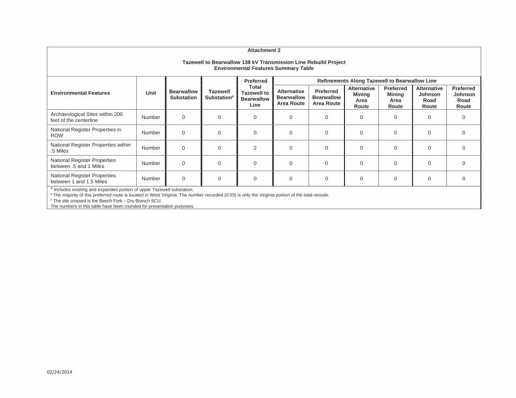
line or within the footprint of the substations. However, two NRHP-eligible properties are located within 0.5 mile of the transmission line: the Amonate Historic District (DHR ID: 092-5133) and the 1935 Trinity Full Gospel Church (DHR ID: 092-5133-0004), which originated as the Amonate Methodist Church and is a contributing resource within the proposed Amonate Historic District. The nearest point within the Amonate Historic District to the proposed transmission line is 0.2 mile. These sites are illustrated on Sheet 6 of Exhibit 5 located in Volume 1 of this application. Given the presence of an existing transmission line in the viewshed, vegetation, and high relief topography it is unlikely that the new transmission structures constructed within the existing ROW will be visible or introduce a new visual element in to the current viewscape of the district. One structure will be partially visible from the northern end of the district; however, the view looking away from the district does not contribute to the setting. It is, therefore, the opinion of Dutton + Associates, LLC that the proposed Project will have a minimal impact on the Amonate Historic District and its current setting. The nearest point from Trinity Full Gospel Church to the proposed transmission line is 0.2 mile. The existing ROW where the transmission line will be built is not visible from Amonate Road or the church. It is, therefore, the opinion of Dutton + Associates, LLC that the proposed Project will have no impact on the Trinity Full Gospel Church and its existing setting.
The VDHR reviewed the Pre-Application Analysis for Cultural Resources of the Tazewell-Buchanan 138 kV Transmission Improvements Project document and provided a response which is included as Attachment 11. The VDHR responded (Attachment 11) that the Project would have minimal impact on the two eligible resources located approximately 0.2 mile from the Project. NRG submitted an August 20, 2014 addendum to the analysis document which addresses the three re-routes. The VDHR responded in a September 17, 2014 letter and confirmed that no cultural resources are located within the tiered study area boundary of the three reroutes.
I. Chesapeake Bay Preservation Areas
The Project is not located within the Tidewater Virginia portion of the Chesapeake Bay watershed. In addition, the construction, installation, operation and maintenance of electric transmission lines are conditionally exempt from the Chesapeake Bay Act as stated in the exemption for public utilities, railroads, public roads and facilities in 9 VAC 10-20-150.
J. Wildlife Resources
As noted in Section 2.F, several federally-listed and state-listed animal species potentially occur in the Project vicinity. Response letters from the VDCR (VDCR, 2014a), VDGIF (VDGIF, 2014a), and USFWS (USFWS, 2014) are included as Attachments 6, 7, and 9, respectively. The VAFWIS (VDGIF, 2014b) review is included as Attachment 8. On August 18, 2014 NRG resubmitted to VDCR an updated review of the Project due to the line reroutes. VDCR responded in a September 10, 2014 letter which is included in Attachment 6. If necessary, APCo will conduct the appropriate surveys to determine if protected species are present and will coordinate with VDCR, VDACS, VDGIF, and USFWS as needed to avoid or minimize impacts to wildlife resources.
K. Recreation, Agricultural, and Forest Resources
This Project is expected to have minimal impact on recreational and agricultural resources. NRG investigated the possible presence of federal, state, and privately owned

VDEQ Supplement Tazewell-Bearwallow 138 kV Transmission Line Rebuild Project
9
conservation lands, scenic rivers, trails, and roads, and agricultural and forestral districts within the Project area through the review of publicly available data from VDCR, the National Park Service, the Virginia Department of Transportation (VDOT), and VDACS. No conservation lands, scenic rivers, trails, and roads, and agricultural and forestral districts or other public lands were located within the Project area (Attachment 12).
An email correspondence with the Virginia Outdoors Foundation (VOF) dated February 19, 2014 concludes, as of that date, that there are no existing or proposed open-space easements in the immediate vicinity of the Project area. VOF asks to be contacted again regarding significant Project area changes or if construction does not begin within 24 months (Attachment 13).
NRG investigated the possible presence of agricultural lands within the Project area and while small areas of the Project may be used for hay/pasture, no cultivated crops or designated agricultural lands were identified.
NRG initiated coordination with the Virginia Department of Forestry (VDOF) concerning the Project. VDOF responded on February 11, 2014 with general comments about potential forestland loss and ROW maintenance plans (Attachment 14). The Tazewell-Bearwallow 138 kV Transmission Line will remain in the existing ROW to the maximum extent possible, but the ROW will require widening from the current 60-foot width to 100 feet. Approximately 60 percent of the existing line is in forested area; thus, upgrading the existing Tazewell-Bearwallow 69 kV Transmission Line instead of creating a new ROW will minimize forestland loss. Minor route adjustments to accommodate landowner requests and/or constructability issues may result in the clearing of up to 5.9 acres of woodlands. Maintenance of trees within the ROW can be limited to just those within 100 feet of the conductor wires based on visual inspections. Tree clearing that would be associated with the upgrade of the facilities would utilize the VDOF’s Best Management Practices for Water Quality.
L. Use of Pesticides and Herbicides
ROW maintenance will be performed in accordance with APCo's ROW clearing, restoration, and maintenance guidelines (see Section II.A.5 of the Response to Guidelines included in Volume 1 of this application). Herbicide use specifications associated with these guidelines include the following:
Herbicides used will be applied in accordance with applicable state and federal laws and regulations;
Herbicides used shall be registered with the USEPA and VDACS;
Herbicides will be used in accordance with the manufacturer's label directions and recommendations;
Herbicide applications will be performed under the direct supervision of certified applicators;
Herbicides will not be applied when rainfall is imminent, during rainfall, or within one day of large rain events (usually greater than 1 cm) that result in soil moisture capacity occurring above field capacity; and
VDEQ Supplement Tazewell-Bearwallow 138 kV Transmission Line Rebuild Project
10
Buffer zones will be maintained around streams, ponds, wetlands, and water supply wells in accordance and compliance with herbicide label directions.
M. Geology and Mineral Resources
NRG investigated the possible presence of mines or mining areas within the study area through the review of publicly available data from the Virginia Department of Mines, Minerals, and Energy website. Additionally, APCo conducted interviews with landowners. The northern portion of the study area, along the Virginia and West Virginia border, traverses some past and future mining areas. One of the proposed reroutes (the “Mining Area Reroute” see Exhibits 1, 4 and 5) is required to avoid proposed mining activity at the landowner’s request. No impacts on mining areas are expected from the proposed Project.
Within a response regarding other resources in the Project area, the VDCR commented that karst features may be present in the area and stated that discharge of runoff to sinkholes or sinking streams can lead to surface collapse, flooding, erosion, groundwater contamination, and degradation of subterranean habitat for natural heritage resources (VDCR, 2014a) (Attachment 6). VDCR recommended contacting the VDCR Karst Program.
NRG initiated correspondence with the VDCR Karst Program. The response (Attachment 15) confirmed that there are no reports of caves within the proposed Project area (VDCR, 2014b). The VDCR Karst Program recommends avoiding herbicide use and using only wetland approved herbicides, such as Rodeo, if necessary. The VDCR Karst Program also asked to be contacted if ground openings (e.g., cave entrances, pits, holes blowing air) are encountered.
N. Transportation Infrastructure
The existing Tazewell-Bearwallow 69 kV Transmission Line crosses 15 roadways, including Virginia Routes 624 and 627. No impacts to these facilities are anticipated from the proposed Project because the roads will be crossed as an overhead span.
NRG initiated coordination with the VDOT regarding the Project and received a response on March 5, 2014 (Attachment 16). The response stated that, except during construction, the Project will have no adverse impacts on existing or future transportation infrastructure. Additional consultation regarding road crossings and ROW permits will occur at the beginning of the design and construction processes.
The existing Tazewell-Bearwallow 69 kV Transmission Line spans the Norfolk Southern Railway in one location. No additional impacts are anticipated concerning the proposed rebuild project.
NRG investigated possible airports within five miles of the Project area using aerial imagery. No airports were found within that distance and thus no impacts are expected.
3.0 REFERENCES
USEPA, 2014a. U.S. Environmental Protection Agency My WATERS Mapper. Available online: http://watersgeo.epa.gov/mwm/. Accessed February, 2014.
VDEQ Supplement Tazewell-Bearwallow 138 kV Transmission Line Rebuild Project
11
USEPA, 2014b. U.S. Environmental Protection Agency’s Toxic Release Inventory Database. Available online at www.epa.gov/enviro/index.html Accessed February 2014.
USFWS, 2014. U.S. Fish and Wildlife Service, Southwestern Virginia Field Office. 2014. Letter dated May 5, from B. Evans to M. Noens (Natural Resource Group, LLC).
USGS, 2014. U.S. Geological Survey National Hydrography Dataset. Available online: http://nhd.usgs.gov/data.html. Accessed February, 2014.
VDCR, 2014. Virginia Department of Conservation and Recreation Natural Heritage Data Explorer. Available online: https://vanhde.org/. Accessed February, 2014.
VDCR, 2014a. Virginia Department of Conservation and Recreation, Division of Natural Heritage. 2014. Letter dated March 5, from S. R. Hypes (Project Review Coordinator) to W. Metcalfe (Natural Resource Group, LLC).
VDCR, 2014b. Virginia Department of Conservation and Recreation. 2014. Letter dated March 17, from W. Orndorff (Karst Program) to M. Noens (Natural Resource Group, LLC).
VDEQ, 2014. Online Database: Virginia Environmental Geographic Information Systems. Available online at http://www.deq.state.va.us/ConnectWithDEQ/VEGIS.aspx Accessed February 2014.
VDGIF, 2014a. Virginia Department of Game and Inland Fisheries. 2014a. Letter dated February 19, from G. Cason (Environmental Services Section) to B. Johnsen (Natural Resource Group, LLC).
VDGIF, 2014b. Virginia Department of Game and Inland Fisheries. 2014b. Fish and Wildlife Information Service Search Report compiled on March 19. Accessed online at http://vafwis.org/fwis/.
VDMME, 2014. Virginia Department of Mines Minerals and Energy Division of Mines Interactive Map. Available online: http://www.dmme.virginia.gov/DMLR/MappingLandingPage.shtml. Accessed February, 2014.
VDOF, 2014. Virginia Department of Forestry. 2014. Letter dated February 11, from G. Evans (Voluntary Mitigation Program Manager) to B. Johnsen (Natural Resource Group, LLC).
VDOT, 2014. Virginia Department of Transportation. 2014. Letter dated March 5, from D. Necessary, Jr. (Bristol District Planner) to B. Johnsen (Natural Resource Group, LLC) and S. Kennedy (American Electric Power).
VOF, 2014. Virginia Outdoors Foundation. 2014. Letter dated February 19, from M. Hallock-Solomon (GIS/IT Specialist) to B. Johnsen (Natural Resource Group, LLC) and S. Kennedy (American Electric Power).
Wellman, J. and S. Coe. 2014. Email communication on January 14 between S. Trichell (Natural Resource Group, LLC) and J. Wellman (VDEQ – Division of Land Protection and Revitalization).


"/
"/
"/
Mining AreaReroute
Bearwallow AreaReroute
Johnsons BranchRoad Reroute
To Welch
TazewellSubstation (VA)
BearwallowSubstation (VA) Faraday
Substation (WV)
BuchananCo. (VA)
TazewellCo. (VA)
McDowellCo. (WV)
Squire
Amonate
Tazewell
Bearwallow
This information is for environmental review purposes only.
0 1 2Miles
City/Town
"/ Existing Substation Yard
State Boundary
County Boundary
Town Boundary
Proposed Transmission Line (Existing ROW)Proposed Transmission Line (New ROW)
Existing 69 kV Transmission Line (To be removed)
Existing Transmission Line pFILE: M:\Clients\A-C\AEP\Tazmac\_ArcGIS\2014\08\Report_Maps_Taze_Bear\_AEP_TazMac_GenLoc_VA.mxd | REVISED: 10/07/2014 | SCALE: 1:100,000 DRAWN BY: JPB
Kentucky
NorthCarolina
Tennessee
Virginia
WestVirginia
General Location MapTazewell - Bearwallow 138 kV
Transmission Line Rebuild Project


02/24/2014
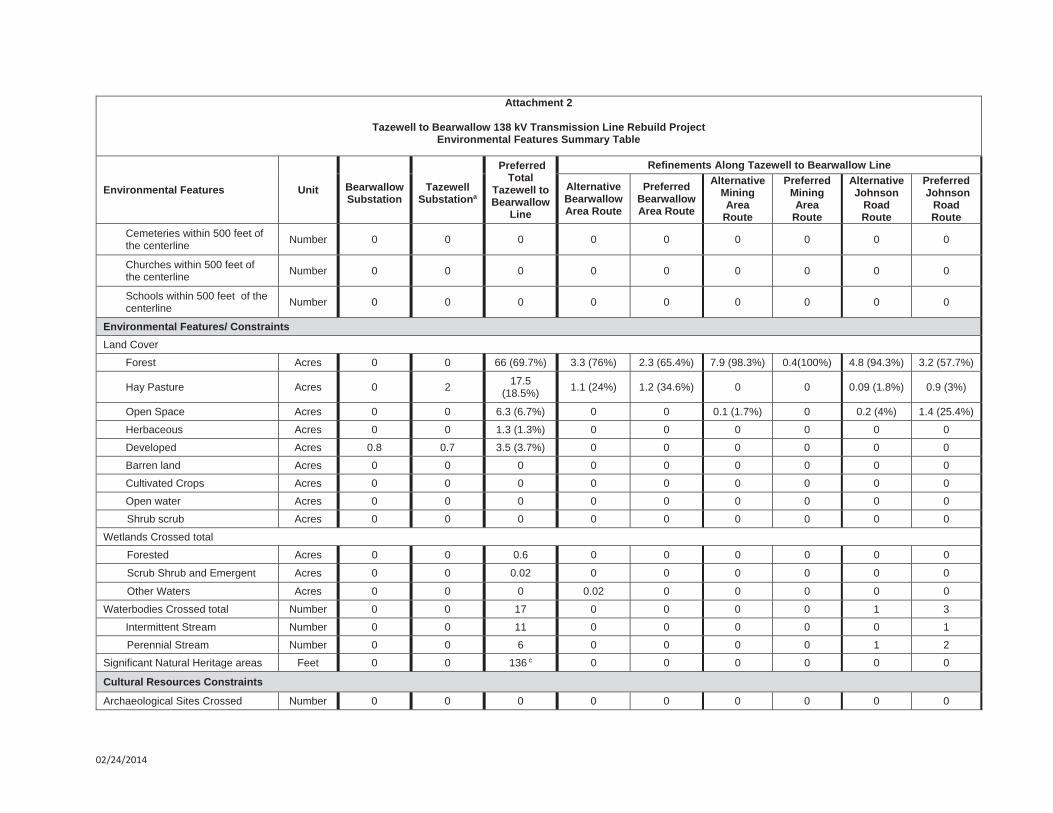
Attachment 2
Tazewell to Bearwallow 138 kV Transmission Line Rebuild Project Environmental Features Summary Table
Environmental Features Unit BearwallowSubstation
Tazewell Substationa
Preferred Total
Tazewell to Bearwallow
Line
Refinements Along Tazewell to Bearwallow Line
Alternative Bearwallow Area Route
PreferredBearwallow Area Route
Alternative Mining Area
Route
PreferredMining Area
Route
Alternative Johnson
RoadRoute
Preferred Johnson
RoadRoute
Engineering ConstraintsWidth Feet n/a n/a 100 100 100 100 100 100 100
Length (total) Feet(miles) n/a n/a 41,186
(7.8) 1,845 (0.3)
1,447 (0.3)
3,477 (0.7)
146(0.03)b
2,119 (0.4)
2,345 (0.4)
Area Acres 0.8 2.7 94.7 4.4 3.5 8 0.4 5 5.6
Roads Crossed U.S. or State Highways Number 0 0 1 0 0 0 0 0 0 County or Local Roads Number 0 0 9 0 0 0 0 0 0
Land Use Features / ConstraintsLand Ownership
Private Feet 0.8 2.7 41,186 1,845 1,447 3,477 146 2,119 2,345
State of Virginia Feet 0 0 0 0 0 0 0 0 0
County Feet 0 0 0 0 0 0 0 0 0
Parcels Crossed Number 0 0 62 1 1 2 1 3 2
Recreational Areas
County or Municipal Parks Crossed Number 0 0 0 0 0 0 0 0 0
Golf Courses Crossed Number 0 0 0 0 0 0 0 0 0
Trails Crossed Number 0 0 0 0 0 0 0 0 0
Other Land Use Constraints Residential dwellings within the 100 foot ROW and/or substation footprint
Number 0 0 9 0 0 0 0 0 0
Residential dwellings within 500 feet of the proposed centerline and/or within 500 feet of the substation footprint
Number 0 14 111 1 0 0 0 8 10
Non-residential buildings within the proposed 100 foot right-of-way and/or substation footprint
Number 0 0 8 0 0 0 0 0 0
02/24/2014
Attachment 2
Tazewell to Bearwallow 138 kV Transmission Line Rebuild Project Environmental Features Summary Table
Environmental Features Unit BearwallowSubstation
Tazewell Substationa
Preferred Total
Tazewell to Bearwallow
Line
Refinements Along Tazewell to Bearwallow Line
Alternative Bearwallow Area Route
PreferredBearwallow Area Route
Alternative Mining Area
Route
PreferredMining Area
Route
Alternative Johnson
RoadRoute
Preferred Johnson
RoadRoute
Cemeteries within 500 feet of the centerline Number 0 0 0 0 0 0 0 0 0
Churches within 500 feet of the centerline Number 0 0 0 0 0 0 0 0 0
Schools within 500 feet of the centerline Number 0 0 0 0 0 0 0 0 0
Environmental Features/ Constraints Land Cover
Forest Acres 0 0 66 (69.7%) 3.3 (76%) 2.3 (65.4%) 7.9 (98.3%) 0.4(100%) 4.8 (94.3%) 3.2 (57.7%)
Hay Pasture Acres 0 2 17.5(18.5%) 1.1 (24%) 1.2 (34.6%) 0 0 0.09 (1.8%) 0.9 (3%)
Open Space Acres 0 0 6.3 (6.7%) 0 0 0.1 (1.7%) 0 0.2 (4%) 1.4 (25.4%)
Herbaceous Acres 0 0 1.3 (1.3%) 0 0 0 0 0 0
Developed Acres 0.8 0.7 3.5 (3.7%) 0 0 0 0 0 0
Barren land Acres 0 0 0 0 0 0 0 0 0
Cultivated Crops Acres 0 0 0 0 0 0 0 0 0
Open water Acres 0 0 0 0 0 0 0 0 0
Shrub scrub Acres 0 0 0 0 0 0 0 0 0
Wetlands Crossed total
Forested Acres 0 0 0.6 0 0 0 0 0 0
Scrub Shrub and Emergent Acres 0 0 0.02 0 0 0 0 0 0
Other Waters Acres 0 0 0 0.02 0 0 0 0 0
Waterbodies Crossed total Number 0 0 17 0 0 0 0 1 3
Intermittent Stream Number 0 0 11 0 0 0 0 0 1
Perennial Stream Number 0 0 6 0 0 0 0 1 2
Significant Natural Heritage areas Feet 0 0 136 c 0 0 0 0 0 0
Cultural Resources Constraints
Archaeological Sites Crossed Number 0 0 0 0 0 0 0 0 0
02/24/2014
Attachment 2
Tazewell to Bearwallow 138 kV Transmission Line Rebuild Project Environmental Features Summary Table
Environmental Features Unit BearwallowSubstation
Tazewell Substationa
Preferred Total
Tazewell to Bearwallow
Line
Refinements Along Tazewell to Bearwallow Line
Alternative Bearwallow Area Route
PreferredBearwallow Area Route
Alternative Mining Area
Route
PreferredMining Area
Route
Alternative Johnson
RoadRoute
Preferred Johnson
RoadRoute
Archaeological Sites within 200 feet of the centerline Number 0 0 0 0 0 0 0 0 0
National Register Properties in ROW Number 0 0 0 0 0 0 0 0 0
National Register Properties within .5 Miles Number 0 0 2 0 0 0 0 0 0
National Register Properties between .5 and 1 Miles Number 0 0 0 0 0 0 0 0 0
National Register Properties between 1 and 1.5 Miles Number 0 0 0 0 0 0 0 0 0
a Includes existing and expanded portion of upper Tazewell substation.b The majority of this preferred route is located in West Virginia. The number recorded (0.03) is only the Virginia portion of the total reroute. c The site crossed is the Beech Fork – Dry Branch SCU. The numbers in this table have been rounded for presentation purposes.

APPALACHIAN POWER COMPANY
Tazewell and McDowell Counties Area 138kV Improvement Project
Desktop Wetland and Waterbody Study
P r e p a r e d b y
A u g u s t 2 0 1 4

Desktop Wetland and Waterbody Study Tazewell and McDowell Counties Area 138kV Improvement Project
i
TABLE OF CONTENTS
1.0 INTRODUCTION ............................................................................................................... 1
2.0 LANDSCAPE DESCRIPTION .......................................................................................... 1
3.0 PROJECT STUDY AREA ................................................................................................. 2
3.1 Whitewood Substation (new) ................................................................................. 23.2 Richlands – Whitewood ......................................................................................... 23.3 Collocated Segment .............................................................................................. 23.4 Whitewood Extension ............................................................................................ 23.5 Tazewell – Faraday – Bearwallow ......................................................................... 23.6 Richland, Tazewell, and Bearwallow Substations ................................................. 33.7 Proposed Route Adjustments ................................................................................ 3
4.0 APCO POLICY ON WETLAND/WATERBODY DISTURBANCE .................................... 3
5.0 DESKTOP EVALUATION METHODOLOGY ................................................................... 4
6.0 GROUND TRUTHING ....................................................................................................... 6
7.0 RESULTS ......................................................................................................................... 6
7.1 Richlands – Whitewood ......................................................................................... 67.2 Collocated Segment .............................................................................................. 67.3 Whitewood Extension ............................................................................................ 67.4 Tazewell - Bearwallow ........................................................................................... 67.5 Desktop Review of Proposed Route Adjustments ................................................. 7
8.0 PROJECT IMPACTS ........................................................................................................ 9
9.0 CONCLUSIONS ................................................................................................................ 9
9.1 Richlands – Whitewood ......................................................................................... 99.2 Collocated Segment .............................................................................................. 99.3 Whitewood Extension ............................................................................................ 99.4 Tazewell – Faraday – Bearwallow ......................................................................... 99.5 Proposed Route Refinements ............................................................................. 10
10.0 CLOSING ........................................................................................................................ 10
11.0 REFERENCES ................................................................................................................ 11
LIST OF TABLES
Table 1 Criteria Used to Rank the Probability of Wetland Occurrence ............................... 5Table 2 Summary of the Probabilities of Wetland Occurrence by Type along Each
Route ..................................................................................................................... 7

Desktop Wetland and Waterbody Study Tazewell and McDowell Counties Area 138kV Improvement Project
ii
LIST OF ATTACHMENTS Attachment 1 Project General Location Map Attachment 2 Resumes Attachment 3 Photographs of Potential Wetland Crossings Attachment 4 Graphics Depicting the Spatial Locations of the Analytical Data
Desktop Wetland and Waterbody Study Tazewell and McDowell Counties Area 138kV Improvement Project
1
1.0 INTRODUCTION
Natural Resource Group, LLC (NRG), on behalf of Appalachian Power Company (APco), conducted a desktop wetland and waterbody review utilizing publically-available information for APco’s proposed Tazewell and McDowell Counties Area 138kV Improvement Project (Project). The Project is needed to enhance system reliability and to accommodate growth in Tazewell County and Buchanan County, Virginia and McDowell County, West Virginia. A general location map depicting the portions of the Project located within the Commonwealth of Virginia is included as Attachment 1.
The majority of the proposed upgrades would occur within existing rights-of-way to the extent practicable; however, minor route adjustments to accommodate constructability/operational constraints may be incorporated into the final design of the Project, which would require deviation from the existing rights-of-way. The proposed Virginia portion of the Project would entail the following:
Rebuilding approximately 8.6 miles of an existing 69 kV line to 138 kV in Tazewell County (Tazewell – Faraday – Bearwallow). An additional 3.7 miles of this line is located in McDowell County, West Virginia.
Construction of approximately 7.5 miles of new 138 kV transmission line located in an existing undeveloped 100-foot ROW in Tazewell (5.7 miles) and Buchanan (1.8 miles) Counties (Richlands – Whitewood 138 kV Transmission Line).
Construction of approximately 0.5 mile of new 138 kV transmission line within the existing, developed 100-foot wide ROW (Collocated Segment), of the Grassy Creek- Hales Branch 138 kV Transmission Line in Buchanan County. This collocated segment will connect the Richlands-Whitewood 138 kV Transmission Line with the Whitewood 138 kV Extension.
Construction of approximately 0.4 mile of new 138 kV transmission line within a new 200-foot ROW in Buchanan County (Whitewood 138 kV Extension) to connect the Whitewood Switchyard to the existing Grassy Creek – Hales Branch 138 kV transmission line.
Construction of one new switchyard in Buchanan County (Whitewood Switchyard). Associated substation improvements at APCo's existing Richlands, Tazewell, and Bearwallow
Substation Sites, including buswork, switches and related equipment.
The purpose of this desktop analysis was to identify and evaluate potential impacts of the Project on wetlands and waterbodies. In accordance with Virginia Department of Environmental Quality (DEQ) and the State Corporation Commission’s (SCC) Memorandum of Agreement, the evaluation was conducted using various data sets that may indicate wetland location and type. The information summarized in this report will be submitted to the DEQ as part of the DEQ Wetland Impacts Consultation.
This assessment did not include the field investigations required for wetland delineations in accordance with the U.S. Army Corps of Engineers Wetland Delineation Manual (Environmental Laboratory, 1987) and the Eastern Mountains and Piedmont Regional Supplement (Environmental Laboratory, 2010).
2.0 LANDSCAPE DESCRIPTION
The proposed Project is located in the Central Appalachians and Ridge and Valley Provinces in Virginia and West Virginia. The Central Appalachians Province is characterized by rugged terrain with high hills and low mountains, step narrow ridges, narrow winding valleys, and deep coves. The region consists mostly of mixed mesophytic forests with oaks (Quercus sp.), maple (Acer sp.), beech (Fagus sp.), and eastern hemlock (Tsuga canadensis). Forested conditions prevail over much of this area with some small pasture areas and surface and underground mining continuing to alter the face of the landscape (Wiken, et al, 2011).
The Ridge and Valley Province is characterized by long, parallel ridges and continuous valleys caused by the region’s extreme folding and faulting events. Historically, the natural vegetation of this area was mostly mixed mesophytic forest with oaks, maple, and eastern hemlocks typically occurring in this region. Present-

Desktop Wetland and Waterbody Study Tazewell and McDowell Counties Area 138kV Improvement Project
2
day use of this area has resulted in this area becoming a mosaic of woodland, pasture, and cropland. Forests currently cover approximately 50% of this area (Wiken, et al, 2011).
3.0 PROJECT STUDY AREA
The study area selected for the desktop analysis encompasses existing rights-of-way in Tazewell County, Virginia and previously established, but not developed, rights-of-way in Tazewell and Buchanan Counties, Virginia, as depicted on Attachment 1. The construction of the Tazewell – Buchanan Area 138 kV Transmission Improvements Project requires the siting and installation of electric transmission lines within primarily existing rights-of-way, in addition to minor route adjustments to accommodate constructability/operational constraints may be incorporated into the final design of the Project, which would require deviation from the existing rights-of-way, to deliver the electricity from the power source to the electric grid. A more detailed description of the Project routes are presented below.
3.1 Whitewood Substation (new)
The Project requires construction of a new substation to connect the Grassy Creek – Hales Branch 138 kV line to the new Richlands – Whitewood 138 kV line. The Whitewood 1A Switchyard review area is approximately 0.89-acre and is located 0.2-mile northwest of the intersection of Osborne Mountain Road and Nipper Road in Buchanan County, Virginia. The proposed switchyard location consists of disturbed residential lands.
3.2 Richlands – Whitewood
The proposed route would begin just north of Highway 460 at an existing deadline coming from the Richlands Substation. The route extends towards the north/northwest across forested land crossing Hill Creek Road near mile post (MP) 2.1 and continues across forested land towards the north/northwest crossing the Buchanan/Tazewell County line near MP 5.7. From this point the route travels directly to the proposed Whitewood Substation. This route consists of a 100-foot-wide right-of-way in which easements were previously secured, but was never cleared and developed. Due to construction constraints and forthcoming Project design and landscape details, the exact location of the proposed route is not yet finalized. The final right-of-way may vary based on the final design.
3.3 Collocated Segment
The Collocated Segment consists of approximately 0.5 mile of new 138 kV transmission line within the existing, developed 100-foot wide ROW of the Grassy Creek- Hales Branch 138 kV Transmission Line in Buchanan County. This collocated segment will connect the Richlands-Whitewood 138 kV Transmission Line with the Whitewood 138 kV Extension.
3.4 Whitewood Extension
The proposed line is necessary to connect the new Whitewood Substation to the existing Grassy Creek – Hales Branch 138 kV transmission line. The approximately 0.4-mile route crosses forest regeneration areas. These lands were previously strip-mined; however, mining operations have ceased and the previously-disturbed areas have begun to regenerate.
3.5 Tazewell – Faraday – Bearwallow
The Tazewell – Faraday – Bearwallow route begins at the existing Bearwallow Substation in Tazewell County, Virginia and proceeds towards the southeast terminating at the Tazewell Substation located in Tazewell County, Virginia. The approximately 12.3-mile route is located along the Virginia/West Virginia state line, and the route crosses the state line numerous times. Approximately 8.6 miles of this route are located in Virginia, and approximately 3.7 miles of this route are located in West Virginia. From the Bearwallow substation, the route proceeds southeast through very sparsely-populated, rural areas with
Desktop Wetland and Waterbody Study Tazewell and McDowell Counties Area 138kV Improvement Project
3
large forested tracks crossing Highway 624, Johnson Branch Road, and Dry Fork Road. The land use changes to low-density residential just north of Tazewell. The route continues southeast crossing Oak Ridge Road, Freemont Road, Mundytown Road, and Vilacha Road before terminating at the existing Tazewell Substation.
In general, the route is primarily forested with very sparsely distributed residential dwellings and small farmsteads. The proposed right-of-way is currently maintained to accommodate an active 69 kV line that has been in service for many decades. The proposed transmission enhancements will utilize this existing right-of-way to the extent practicable.
3.6 Richland, Tazewell, and Bearwallow Substations
The Project requires improvements to three existing substation sites located in Tazewell County, Virginia. The sites have been previously developed and used as substations for the 69 kV system. Slight modifications to the footprints of these substations to accommodate the higher voltage will be required and may result in minimal land disturbance outside of the existing fenced area. The assessment of wetlands associated with this additional disturbance has been incorporated into the area of disturbance reviewed for the associated transmission line improvements.
3.7 Proposed Route Adjustments
The Project may require minor route refinements to accommodate landowner requests and constructability/operational constraints along the Tazewell-Bearwallow portion of the Project. The route refinements generally follow and only deviate from an existing transmission ROW for the minimum distance necessary. The desktop assessment of wetlands associated with these route refinements have been incorporated into the area of disturbance reviewed for the associated transmission line improvements.
4.0 APCO POLICY ON WETLAND/WATERBODY DISTURBANCE
APco will delineate wetlands and waterbodies onsite prior to commencing Project activities in accordance with applicable rules and guidelines. In the event that wetlands are encountered, APco will minimize ground disturbance, minimize the extent of vegetation clearing in areas that may affect the wetland, leave a vegetated buffer around the wetland, re-establish wetland vegetation that may temporarily affected during construction, and apply best management practices in accordance with erosion and sediment control practices.
Waterbody crossings may require limited equipment access crossings or riparian vegetation clearing in instances where conductor clearance does not meet minimum standards. However, in the steep terrain and narrow valleys of the Project area, the spanning of valleys will be incorporated into the Project design and will likely minimize the need to clear riparian areas adjacent to waterbodies.
Specific avoidance, minimization and mitigation measures may include:
Siting tower footings outside of waterbody and/or wetland areas; Use of removable timber mats to cross waterbodies and/or wetlands to minimize ground
disturbance; Crossing waterbodies with minimal disturbance to the vegetative canopy of the riparian corridor.
Provide a vegetative buffer of at least 50 feet along each side of the waterbody; A wetland may be considered impacted if construction activity takes place immediately upslope
and adjacent to the wetland. If impacted, mitigation measures should follow general criteria, standards, and specifications for drainage ways and waterbody protection in the erosion and sediment control specifications;
Using low residual herbicides in accordance with label directions;
Desktop Wetland and Waterbody Study Tazewell and McDowell Counties Area 138kV Improvement Project
4
Preparation of a resource protection and management plan in consultation with the appropriate federal and state agencies prior to the final transmission system design; and
Specific mitigation measures may be developed on a case-by-case basis for major wetland resource impacts.
5.0 DESKTOP EVALUATION METHODOLOGY
The area of effect considered for this study consists of the proposed rights-of-way identified above in which the electric transmission lines would be constructed and operated. Data sources used for this review include the following, each of which is described briefly below:
National Agricultural Imagery Program (NAIP) Digital Ortho-Rectified Natural Color Images, Virginia, 1-meter pixel resolution, photo date 2012;
NAIP Digital Ortho-Rectified Infrared Images, Virginia, 1-meter pixel resolution, photo date 2011; U.S. Geological Survey (USGS) 7.5-minute topographic mapping; USGS Digital Elevation Models (DEMs); U.S. Fish and Wildlife Service (USFWS) National Wetland Inventory (NWI) mapping; U.S. Department of Agriculture-Natural Resources Conservation Service (USDA-NRCS) Soil
Survey Geographic (SSURGO) database for Tazewell and Buchanan Counties, Virginia; and USGS National Hydrography Dataset (NHD).
Natural Color and Infrared Aerial Photography
Recent (2012) natural color aerial photography was used to provide a visual overview of the Project area and to assist in evaluating current conditions. Recent (2011) infrared aerial photography was used to identify the potential presence of wetlands based on signatures associated with the levels of reflectance. For example, areas that are inundated with water appear very dark (almost black) due to the low level of reflectance in the infrared spectrum. The presence of these dark colors can be used as a potential indicator of hydric or inundated soils that are likely associated with wetlands.
USGS Topographic Maps and DEMs
The USGS topographic maps and DEMs show the topography of the area. The USGS topographic maps also depict other important landscape features such as forest cover, development, buildings, mining areas, streams, lakes, and wetlands.
NWI Maps
The NWI maps provide the boundaries and classifications of potential wetland areas as mapped by the USFWS. However, NWI data is based primarily on aerial photo interpretations with limited ground-truthing and may represent incorrect boundaries or wetland cover types. NWI data can be unreliable in some areas, especially in forested landscapes, when aerial photography is used as the major data source. The classifications of the majority of the NWI polygons in the study area appear to be accurate based on a review of the cover types observed in the aerial photography. However, in areas where there was an obvious discrepancy between the NWI classification and the aerial photography, NRG modified the classification to more accurately reflect current conditions. For example, an area of pasture mapped by NWI data as open water may be adjusted to an emergent wetland type based on aerial interpretation. For the purposes of this review, wetlands mapped as unconsolidated bottom were considered open water. In order to acknowledge NRG’s adjustment of NWI classifications where appropriate, all of the wetland types referenced in this assessment are referred to as “assigned wetland cover types” regardless of whether the cover type was actually modified from the NWI classification.
Desktop Wetland and Waterbody Study Tazewell and McDowell Counties Area 138kV Improvement Project
5
USDA-NRCS Soils Data
The soils in the study area were identified and assessed using the SSURGO database, which is a digital version of the original county soil surveys. The attribute data within the SSURGO database provides the proportionate extent of the component soils and their properties (e.g., hydric rating) for each soil map unit. The soils in the study area were grouped into three categories based on the hydric rating of the component soils within each map unit: hydric, partially hydric, and non-hydric. Hydric soils were defined as those where the major component soils, and minor components in some cases, are designated as hydric. Hydric components in these map units account for more than 80 percent of the map unit. Partially hydric soils include map units that only contain minor component soils that are designated as hydric. The partially hydric map units in the Project area contain 10 percent or less hydric soils. The remaining map units do not contain any component soils that are designated as hydric. Areas mapped as hydric or partially hydric have a higher probability of containing wetlands than areas with no hydric soils.
USGS National Hydrography Data
The NHD contains features such as lakes, ponds, streams, rivers, canals, dams and stream gages. The waterbodies mapped by the NHD appeared consistent with those visible on the USGS maps and aerial photography. However, in areas where there was an obvious discrepancy between the location of the NHD feature and the aerial photography, NRG modified the location to more accurately reflect current conditions.
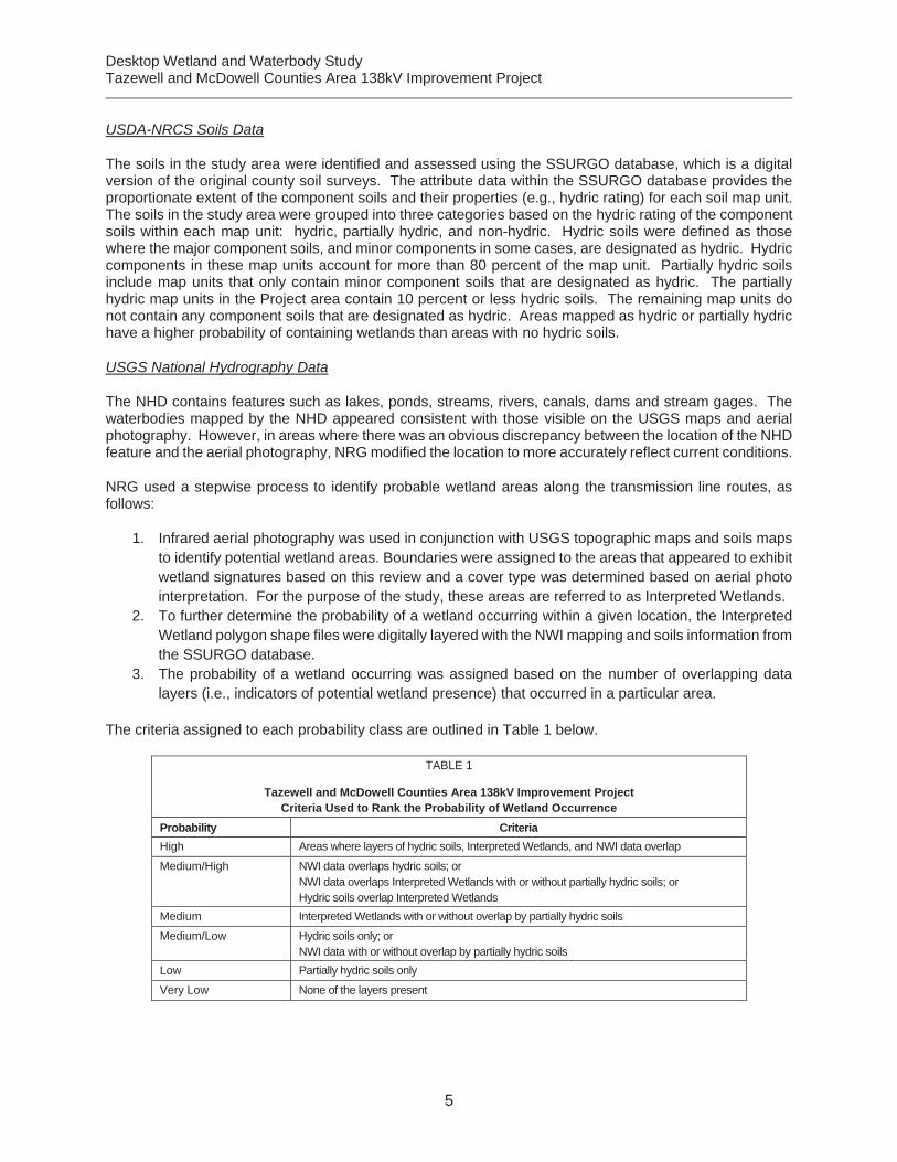
NRG used a stepwise process to identify probable wetland areas along the transmission line routes, as follows:
1. Infrared aerial photography was used in conjunction with USGS topographic maps and soils maps to identify potential wetland areas. Boundaries were assigned to the areas that appeared to exhibit wetland signatures based on this review and a cover type was determined based on aerial photo interpretation. For the purpose of the study, these areas are referred to as Interpreted Wetlands.
2. To further determine the probability of a wetland occurring within a given location, the Interpreted Wetland polygon shape files were digitally layered with the NWI mapping and soils information from the SSURGO database.
3. The probability of a wetland occurring was assigned based on the number of overlapping data layers (i.e., indicators of potential wetland presence) that occurred in a particular area.
The criteria assigned to each probability class are outlined in Table 1 below.
TABLE 1
Tazewell and McDowell Counties Area 138kV Improvement Project Criteria Used to Rank the Probability of Wetland Occurrence
Probability Criteria High Areas where layers of hydric soils, Interpreted Wetlands, and NWI data overlap
Medium/High NWI data overlaps hydric soils; or NWI data overlaps Interpreted Wetlands with or without partially hydric soils; or Hydric soils overlap Interpreted Wetlands
Medium Interpreted Wetlands with or without overlap by partially hydric soils
Medium/Low Hydric soils only; or NWI data with or without overlap by partially hydric soils
Low Partially hydric soils only
Very Low None of the layers present

Desktop Wetland and Waterbody Study Tazewell and McDowell Counties Area 138kV Improvement Project
6
The initial desktop review was performed by Spencer Trishell, Professional Wetland Scientist (PWS) # 2374, and reviewed by Will Metcalfe, PWS # 2248. Additional desktop reviews were conducted by Claire Garvin. Resumes are included in Attachment 2.
6.0 GROUND TRUTHING
Limited field reviews were conducted on February 28, 2014. The field reviews served as a groundtruthing to verify the validity of data sources used in the desktop analysis. Field reviews of potential wetlands and streams within the study area were limited to paved or gravel roads and other public access points. Please note, field reviews were not conducted on the three proposed route refinements discussed below. Potential wetlands and streams located on private property and not viewable from public access points were not reviewed and could not be verified. Three potential wetland locations were reviewed in the field. Based on the results of the field review one of the potential wetland locations was verified to contain wetlands. Two of the three wetland locations were determined to contain uplands based on observed upland soils. Photographs of typical wetlands crossed by the Project are located in Attachment 3.
7.0 RESULTS
A range of wetland occurrence probabilities are reported by this study from very low to high. The probability of wetland occurrence increases as multiple indicators begin to overlap towards the “high” end of the spectrum. For purposes of this study, the medium, medium-high and high probability categories have been determined to be the most representative of in-situ conditions and therefore only the medium, medium-high and high categories are reported in the summary below. Graphics depicting the spatial locations of the data used in this analysis is included in Attachment 4.
7.1 Richlands – Whitewood
The Richlands – Whitewood route is approximately 7.5 miles long; the 100-foot-wide right-of-way along this route encompasses a total of approximately 91.1 acres. Based on the methodology discussed above, the right-of-way will encompass less than 1% (0.9 acre) of land with a medium or higher probability of containing wetlands. Based on NHD, this route crosses 7 intermittent and 4 perennial waterbodies.
7.2 Collocated Segment
The Collocated Segment is approximately 0.5 miles long; the 100-foot-wide right-of-way along this route encompasses a total of approximately 5.6 acres. Based on the methodology discussed above, the right-of-way will encompass less than 6.4% (0.4 acre) of land with a medium or higher probability of containing wetlands. Based on NHD, this route does not cross any waterbodies.
7.3 Whitewood Extension
The Whitewood Extension route is approximately 0.4 mile long; the 200-foot-wide right-of-way along this route encompasses a total of approximately 9.7 acres. Based on the methodology discussed above, the right-of-way will encompass approximately 14.6% (1.4 acre) of land with a medium or higher probability of containing wetlands. Based on NHD, this route does not cross any waterbodies.
7.4 Tazewell - Bearwallow
The Tazewell - Bearwallow route is approximately 12.5 miles long with 7.8 miles occurring in Virginia; the 100-foot-wide right-of-way along this route encompasses a total of approximately 94.6 acres. Based on the methodology discussed above, the right-of-way will encompass less than 1% (0.62 acre) of land with a medium or higher probability of containing wetlands. Based on NHD, this route crosses 5 intermittent and 6 perennial waterbodies.

Desktop Wetland and Waterbody Study Tazewell and McDowell Counties Area 138kV Improvement Project
7
7.5 Desktop Review of Proposed Route Adjustments
This section describes and evaluates route adjustments alng the Tazewell-Bearwallow transmission line.
Landowner Re-Route
This proposed route adjustment is approximately 0.29 mile long (1,519 feet); the right-of-way along this route encompasses a total of approximately 3.49 acres. Based on the methodology discussed above, the right-of-way does not encompass land with a medium or higher probability of containing wetlands. Based on review of the topographic maps and the NHD, this route does not cross any waterbodies.
Mining Area Re-Route
This proposed route adjustment is approximately 1.37 miles long (7,221 feet) with approximately 7,051 feet of the route adjustment occurring in West Virginia and approximately 170 feet occuring in Virginia. The right-of-way along this route encompasses a total of approximately 16.6 acres. Based on the methodology discussed above, the right-of-way does not encompass land with a medium or higher probability of containing wetlands. Based on review of topographic maps and the NHD, this route crosses two intermittent waterbodies.
Johnsons Branch Road Reroute
This proposed route adjustment is approximately 0.43 mile long (2,274 feet); the right-of-way along this route encompasses a total of approximately 5.22 acres. Based on the methodology discussed above, the right-of-way does not encompass land with a medium or higher probability of containing wetlands. Based on review of topographic maps and the NHD, this route crosses one perennial waterbody and one intermittent waterbody. The route refinement segment runs parallel to an existing road with Dick Creek also running parallel to the proposed route adjustment right-of-way for the entire route adjustment length.
TABLE 2
Tazewell and McDowell Counties Area 138kV Improvement Project Summary of the Probabilities of Wetland Occurrence by Type along Each Route
Probability Total Acres Wetland Type (acres)
Forest Scrub/shrub Emergent
Richlands- Whitewood
High 0 0 0 0
Medium/High 0.23 0.23 0 0
Medium 0.62 0.62 0 0
Medium/Low 0 N/A N/A N/A
Low 0.31 N/A N/A N/A
Very Low 88.80 N/A N/A N/A
Collocated Segment
High 0 0 0 0
Medium/High 0 0 0 0
Medium 0.36 0.36 0 0
Medium/Low 0 N/A N/A N/A
Low 0 N/A N/A N/A
Very Low 5.15 N/A N/A N/A
Whitewood Extension
High 0 0 0 0
Desktop Wetland and Waterbody Study Tazewell and McDowell Counties Area 138kV Improvement Project
8
TABLE 2
Tazewell and McDowell Counties Area 138kV Improvement Project Summary of the Probabilities of Wetland Occurrence by Type along Each Route
Probability Total Acres Wetland Type (acres)
Forest Scrub/shrub Emergent
Medium/High 0 0 0 0
Medium 1.42 1.42 0 0
Medium/Low 0.24 N/A N/A N/A
Low 0 N/A N/A N/A
Very Low 8.02 N/A N/A N/A
Tazewell – Faraday – Bearwallow
High 0 0 0 0
Medium/High 0 0 0 0
Medium 0.62 0.60 0 0.02
Medium/Low 0.01 N/A N/A N/A
Low 0.83 N/A N/A N/A
Very Low 101.42 N/A N/A N/A
Proposed Route Refinements
Landowner Re-Route
High 0 0 0 0
Medium/High 0 0 0 0
Medium 0 0 0 0
Medium/Low 0 0 0 0
Low 0 0 0 0
Very Low 0 0 0 0
Mining Area Re-Route
High 0 0 0 0
Medium/High 0 0 0 0
Medium 0 0 0 0
Medium/Low 0 0 0 0
Low 0 0 0 0
Very Low 0 0 0 0
Johnsons Branch Road Re-Route
High 0 0 0 0
Medium/High 0 0 0 0
Medium 0 0 0 0
Medium/Low 0 0 0 0
Low 0 0 0 0
Very Low 0 0 0 0
N/A = Not applicable because areas assigned a probability based on the presence of hydric soils alone do not have an assigned cover type.

Desktop Wetland and Waterbody Study Tazewell and McDowell Counties Area 138kV Improvement Project
9
8.0 PROJECT IMPACTS
APco will incorporate minimization of impacts on streams and wetlands to the extent practicable; however, some wetland and/or stream impacts may occur as a result of the Project. The majority of impacts on wetlands will be temporary and limited to the construction period. Conversion of forested wetlands to emergent or scrub-shrub communities would be the most prevalent effect that the Project would have on wetlands. The overhead transmission line itself will span the wetlands, and the spacing of the support structures and small amount of wetlands along the route will generally allow for the footings to be installed in upland areas. Foundation locations will avoid wetlands wherever possible. Although not anticipated, if excavation for a structure is necessary in a wetland, excess spoil will not be disposed of in adjacent wetland areas. Operations and Maintenance impacts along the transmission line will be similar to those for an existing line and would be limited to periodic maintenance clearing of the right-of-way.
9.0 CONCLUSIONS
Several wetland and stream crossings were identified during the Desktop Wetland Analysis and ground-truthing for the Project. Due to the topographic location of a large portion of the project and limited access, only a small percentage of crossings identified during the Desktop analysis could be accessed for ground-truthing. Prior to commencing project work, all wetlands and streams within the area of disturbance (including access roads) will be delineated. It is anticipated that wetlands and streams will be spanned, avoided or mitigated during line design and construction. Based on current preliminary Project plans, no permanent wetland impacts are expected in association with the construction, maintenance and operation of the Project route. Based on NRG’s desktop analysis, the following is a summary of the aquatic features crossed by each Project option.
9.1 Richlands – Whitewood
The Richlands – Whitewood route is approximately 7.5 miles long; the 100-foot-wide right-of-way along this route encompasses a total of approximately 91.1 acres. Based on the methodology discussed above, the right-of-way will encompass less than 1% (0.9 acre) of land with a medium or higher probability of containing wetlands. Based on NHD, this route crosses 7 intermittent and 4 perennial streams.
9.2 Collocated Segment
The Collocated Segment is approximately 0.5 miles long; the 100-foot-wide right-of-way along this route encompasses a total of approximately 5.6 acres. Based on the methodology discussed above, the right-of-way will encompass less than 6.4% (0.4 acre) of land with a medium or higher probability of containing wetlands. Based on NHD, this route does not cross any waterbodies.
9.3 Whitewood Extension
The Whitewood Extension route is approximately 0.4 mile long; the 200-foot-wide right-of-way along this route encompasses a total of approximately 9.7 acres. Based on the methodology discussed above, the right-of-way will encompass approximately 14.6% (1.4 acre) of land with a medium or higher probability of containing wetlands. Based on NHD, this route does not cross any waterbodies.
9.4 Tazewell – Faraday – Bearwallow
The Tazewell – Faraday – Bearwallow route is approximately 12.3 miles long with 8.6 miles occurring in Virginia; the 100-foot-wide right-of-way along this route encompasses a total of approximately 104.24 acres. Based on the methodology discussed above, the right-of-way will encompass less than 1% (0.62 acre) of land with a medium or higher probability of containing wetlands. Based on NHD, this route crosses 5 intermittent and 6 perennial streams.
Desktop Wetland and Waterbody Study Tazewell and McDowell Counties Area 138kV Improvement Project
10
9.5 Proposed Route Refinements
Landowner Re-Route
This proposed collocated segment is approximately 0.29 mile long; the right-of-way along this route encompasses a total of approximately 3.49 acres. Based on the methodology discussed above, the right-of-way does not encompass land with a medium or higher probability of containing wetlands. Based on review of the topographic maps and the NHD, this route does not cross any waterbodies.
Mining Area Re-Route
This proposed collocated segment is approximately 1.37 miles long; the right-of-way along this route encompasses a total of approximately 16.6 acres. Based on the methodology discussed above, the right-of-way does not encompass land with a medium or higher probability of containing wetlands. Based on review of topographic maps and the NHD, this route crosses two intermittent waterbodies.
Johnsons Branch Road Re-Route
This proposed collocated segment is approximately 0.43 mile long; the right-of-way along this route encompasses a total of approximately 5.22 acres. Based on the methodology discussed above, the right-of-way does not encompass land with a medium or higher probability of containing wetlands. Based on review of topographic maps and the NHD, this route crosses and runs parallel to one perennial waterbody and crosses one intermittent waterbody.
10.0 CLOSING
This Wetland and Waterbody Summary report was prepared in accordance with the Memorandum of Agreement between the Department of Environmental Quality and the State Corporation Commission for purposes of initiating a Wetlands Impact Consultation. Please note: a formal onsite wetland delineation was not conducted as part of this review.
If you have any questions regarding this wetland assessment please contact me at 980-297-7279 or by email at [email protected].
Sincerely,
Natural Resource Group, LLC
_______________________________ _______________________________ Spencer Trichell Will Metcalfe Professional Wetland Scientist 2374 Professional Wetland Scientist 2248

Desktop Wetland and Waterbody Study Tazewell and McDowell Counties Area 138kV Improvement Project
11
11.0 REFERENCES
Environmental Laboratory. 1987. Technical Report Y-87-1: Corps of Engineers Wetlands Delineation Manual US Army Corps of Engineers, Waterways Experiment Station. January 1987
Environmental Laboratory. 2010. Interim Regional Supplement to the Corps of Engineers Wetland Delineation Manual: Eastern Mountains and Piedmont Region. Prepared for U.S. Army Corps of Engineers Wetlands Regulatory Assistance Program. ERDC/EL TR-10-9. July 2010.
National Agricultural Imagery Program (NAIP). 2012. Digital Ortho-Rectified Natural Color Images and NAIP Digital Ortho-Rectified Infrared Images (2011). Available online at http://www.fsa.usda.gov/FSA/apfoapp?area=home&subject=prog&topic=nai. Accessed January 2014.
Natural Resource Conservation Service (NRCS). 2014. Soil Survey Geographic Data (SSURGO). Available online at http://soils.usda.gov/survey/geography/ssurgo/. Accessed January 2014.
U.S. Fish and Wildlife (USFWS). 2014. National Wetlands Inventory. Available online at http://www.fws.gov/wetlands/. Accessed January 2014.
U.S. Geological Survey (USGS). 2014. U.S. Geological Survey. Digital Elevation Model (DEM). Available online at http://eros.usgs.gov/#/Guides/dem. Accessed January 2014.
U.S. Geological Survey (USGS). 2014. U.S. Geological Survey. The National Hydrography Dataset. Available online at http://nhd.usgs.gov/. Accessed January 2014.
Wiken, Ed, Franisco Jimenez Nava, and Glenn Griffith. 2011. North American Terrestrial Ecoregions – Level III. Commission for Environmental Cooperation, Montreal, Canada.

Desktop Wetland and Waterbody Study Tazewell and McDowell Counties Area 138kV Improvement Project
Attachment 1
Project General Location Map

"6
"6
#0
#0
#0
#0
Whitewood138 kV
Extension
CollocatedSegment
ab460
ab460
¡¢19
¡¢52
¡¢52
¡¢19
¡¢11
¡¢19
YXZ81
BlandCo.
BuchananCo.
RussellCo.
SmythCo.
TazewellCo.
WytheCo.
McDowellCo.
MercerCo.
VirginiaWest Virginia
Richlands
Tazewell
Bearwallow
FaradayWhitewood
Montcalm
Bramwell
Anawalt
Pocahontas
Bluefield
Jenkinjones
Bradshaw
Bluefield
War
Tiptop
Squire
Bastian
JewellValley
AmonateJewell Ridge
BurkesGarden
TazewellRed Ash
Cedar Bluff
RichlandsRaven
Claypool Hill
Honaker
BroadfordThis information is for environmental review purposes only.
0 5 10Miles
"6 Proposed Substation#0
Existing Substation
Existing Transmission Line
Tazewell - Faraday -Bearwallow 138 kV (RebuildLine)Richlands - Whitewood 138kV (New Line)
Whitewood 138 kV Extension(New Line)
Collocated Segment (NewLine) p
FILE: M:\Clients\A-C\AEP\Tazmac\_ArcGIS\2014\05\General_Location\_AEP_TazMac_GenLoc_VA.mxd | REVISED: 05/05/2014 | SCALE: 1:300,000 DRAWN BY: Lindsay Sheldon
Kentucky
NorthCarolina
Tennessee
Virginia
WestVirginia
Overview MapTazewell and McDowell Counties
Area 138kV ImprovementProject

Desktop Wetland and Waterbody Study Tazewell and McDowell Counties Area 138kV Improvement Project
Attachment 2
Resumes for Mr. Trishell, PWS and Mr. Metcalfe, PWS
Spencer D. Trichell, PWS e-mail: [email protected]
Spencer Trichell is a Consultant in Natural Resource Group, LLC’s (NRG) Charlotte office. Spencer has been working in the industry since 2002 and specializes in erosion and sediment control implementation, the National Environmental Policy Act; Section 404/401 (Clean Water Act) permitting; the Pennsylvania Department of Environmental Protection (PADEP) Chapter 105 permitting; Pennsylvania State Programmatic General Permit (PASPGP) 4 permitting; Georgia Environmental Protection Division stream buffer variance; mitigation banking management; Florida Environmental Resource permitting; jurisdictional waters determination; Endangered Species Act consultations; ecological surveys and baseline assessments; habitat restoration and compensatory mitigation; complex project management; and client development and relations. Spencer is a Professional Wetland Scientist who has a Bachelor’s of Science in Biology and has had extensive training and experience in a number of areas including resource permitting, hydric soil determination, plant identification, and wetland/waters resource determination/delineation.
Selected Project Experience
Access Midstream Services, LLC, South Evanchick and Auburn GGS buildouts, September 2011 – July 2013, approximately 160 miles of 8-inch-diameter to 20-inch-diameter pipeline with three new compressor facilities to gather Marcellus Shale natural gas in Pennsylvania: Project Manager responsible for route development and feasibility; survey; alignment plans; resource delineations; resource permitting (Pennsylvania Natural Diversity Inventory (PNDI) and PADEP: Erosion and Sediment Control General Permit, PASPGP, and Water Obstruction and Encroachment permitting); stream bank stability assessments and restoration; agency coordination; engineering; client relations and communications; construction coordination; budget and cost control; and permit closeout.
Atlas Resource Partners, LP, Rhodes to Stubler, July 2012 – July 2013, approximately 3 miles of pipeline with two well pads to gather Marcellus Shale natural gas in Pennsylvania: Ecological Quality Control Manager responsible for agency coordination and review of Joint Permit Application for Individual Water Obstruction and Encroachment and PASPGP permit applications.
Williams Midstream, various pipelines and compressor facilities, March 2012 – July 2013, 1 mile of pipeline and three compressor facilities to gather and deliver Marcellus Shale natural gas to market in Pennsylvania: Ecological Practice Lead responsible for wetland and water resource identification, PNDI coordination, preparation of PASPGP, and General Permit applications.
Southern Nuclear, Plant Vogtle, January 2010 – March 2012, addition of reactors 3 and 4 to the existing plant in Georgia: Project Manager responsible for negotiating Section 404 Clean Water Act permit for stream and wetland impacts.
Mississippi Power, Kemper County Energy Facility, July 2008 – December 2009, development of approximately 6 miles of natural gas pipeline, 42 miles of CO2
transmission pipeline, over 50 miles of high-voltage powerline, and 1,200 acres associated with plant development in Mississippi: Project Manager responsible for coordinating resource delineations, preparation of ecological components of the Environmental Impact Statement (EIS), preparation of Section 404 and 401 Clean Water Act permit applications, negotiations with resource agencies, and client coordination.

Spencer D. Trichell Page 2 of 2
Department of Energy, Richton Salt Dome, August 2008 – May 2009, biological assessment of the proposed Strategic Petroleum Reserve site in Mississippi: Project Manager responsible for coordinating resource delineations and preparation of biological assessment for ecological components of the EIS.
Numerous residential, commercial, municipal projects in the Southeastern U.S., June 2002 – September 2010, conduct and manage stream and wetland delineations, habitat assessments, stream and wetland functional assessments, Section 404/401 Clean Water Act permitting, compensatory mitigation plans, and quality reviews and training of junior wetland ecologist.
Education and Training
B.S., Biology, University of Louisiana at Monroe, Monroe, Louisiana, 2001 PAPSSA, Hydric Soil Determination (Lower Glaciated Plateau) Eagle Hill Institute, Graminoid Identification (Northeastern United States) D&D WEST, Endangered Species Act Consultations D&D WEST, Advanced Hydric Soils (Coastal Plain) North Carolina State University, Natural Stream Channel Design and Assessment (Piedmont and Coastal Plain) Richard Chinn, Wetland Delineation 62-340 FAC (Florida) National Technical Committee for Hydric Soils (Wade Hurt), Hydric Soil Determination (Florida)
Certifications
Professional Wetland Scientist #2374, Society of Wetland Scientists

William J. Metcalfe, PWS e-mail: [email protected]
Mr. William Metcalfe is a Consultant at NRG and an accredited Professional Wetland Scientist in accordance with the Society of Wetland Scientists Professional Certification Program. Mr. Metcalfe, prior to joining NRG in 2012, worked in Florida as an environmental consultant for a national civil-engineering firm. Will has performed specific-specific plant and animal surveys, and wetland delineations throughout Florida and is very familiar with the unique biota and ecosystems endemic to the state. Will is also a Florida Fish and Wildlife Conservation Commission (FWC) authorized agent, licensed to survey and excavate gopher tortoises and burrowing owls, and to apply for nest removal and other FWC “incidental take” permits.
Mr. Metcalfe has been working as an environmental professional since 2006, specializing in regulatory issues, agency consultations, and preparing local, state, and federal permits including U.S. Army Corps of Engineers and FERC applications. He has a B.S. in Biology from the University of Pittsburgh, Pennsylvania and an M.S. in Marine Science from the College of William and Mary, Virginia. Mr. Metcalfe has experience preparing Environmental Resource Reports for several FERC Section 7(c) pipelines and natural gas storage project applications. In addition, Mr. Metcalfe has worked on projects throughout the coastal southeastern U.S. and Gulf where his responsibilities included preparation of NEPA documentation, Phase I Environmental Site Assessments, conducting and managing T&E species field surveys, seagrass surveys, benthic habitat assessments, wetland delineations, wetland mitigation, environmental data analysis, and post construction wetland compliance monitoring of pipeline rights-of-way.
Selected Project Experience Williams and Boardwalk Pipeline Partners, LP, Bluegrass Pipeline Project, Environmental Permitting Lead for new 188-mile greenfield pipeline route traversing Kentucky. Field Survey Coordinator for 300+ mile new greenfield pipeline route traversing Pennsylvania, West Virginia and Ohio. ONEOK, Sterling Pipeline Project, July 2012 – Present, performed environmental services in support of environmental clearance for the National Environmental Policy Act (NEPA), project scientist responsible for performing wetland and waterbody delineations and reporting in multiple counties throughout east Texas. NiSource Gas Transmission and Storage, Smithfield III Expansion Project, October 2012 – Present, environmental services to support NiSource Gas Transmission and Storage’s compressor station expansion project, in Pennsylvania and West Virginia: Environmental Lead responsible for field surveys, agency consultations, preparation of the Environmental Report, preparation of Federal Energy Regulatory Commission’s (FERC) Resource Reports 2, 6 and 7, and environmental permitting. NiSource Gas Transmission and Storage, West Side Expansion Interconnect Project, October 2012 – Present, environmental services to support NiSource Gas Transmission and Storage’s compressor station expansion project, in Kentucky and Louisiana: Environmental Lead responsible for field surveys, agency consultations, preparation of the Environmental Report, and environmental permitting. Columbia Gas Transmission, LLC, Seneca Compressor Station Upgrade Project, December 2012, application to the FERC Blanket Certificate Program for improvements
William J. Metcalfe Page 2 of 2
to the Seneca Compressor Station located in Pendleton County, West Virginia: Project Scientist responsible for preparation of FERC Resource Reports 2, 6, and 7. Dominion Virginia Power, Chickahominy to Skiffes Creek 500 kilovolt (kV) and Skiffes Creek to Whealton 230 kV Transmission Line Project Environmental Route Review, March 2011 – April 2012, approximately 72 miles of 230 kV and 500 kV new and existing electric transmission line in multiple counties in Tidewater, Virginia: Biological Lead responsible for preparation of Environmental Conditions and Environmental Resources affected portions of route review document. NiSource Columbia Gas Transmission, LLC, Vepco – Warren County, Virginia Project, March 2011 – Present, construction of a new interconnect at the Rockville Measuring Station site between an existing 26-inch-diameter pipeline and Transcontinental Pipeline Corporation’s system (Transco) in Montgomery County and the City of Rockville, Maryland: Environmental Lead responsible for protected species issues and preparation of erosion and sediment control and stormwater management permit applications. Dominion – North Carolina Power, Shawboro to Aydlett 230 kV Transmission Line Routing Study, February 2011 – December 2011, approximately 11 miles of new, single circuit 230 kV electric transmission line between its existing Shawboro Substation and a point near the Aydlett Substation entirely within Currituck County, North Carolina: Biological Lead responsible for preparation of Environmental Conditions and Environmental Resources affected portions of route review document. Williams Gas, Laurel Mountain Midstream, LLC, Citro to Cantaral Pipeline Project, October 2011 – Present, approximately 3 miles of 16-inch-diameter new natural gas gathering pipeline in Greene County, Pennsylvania: Environmental Lead responsible for wetland and waterbody delineation, habitat assessment, preparation of erosion and sediment control design and permit application, utility line stream crossing permit application, minor road crossing permit application, and temporary road crossing permit application. Kimley-Horn and Associates, March 2006 – October 2011, Florida: Environmental Scientist responsible for addressing constraints affecting project development; coordinated findings and recommendations with engineers, architects, planners, and regulatory agency staff; and acted as a liaison to develop and facilitate resolutions. Virginia Institute of Marine Science, August 2003 – March 2006, Chesapeake Bay Region, Virginia: Graduate Assistant/Contract Employee responsible for collecting and analyzing benthic infauna data along organic and inorganic enrichment gradients at military facilities throughout Chesapeake Bay.
Education and Training M.S., Marine Science, College of William and Mary – December 2005 B.S., Biology, University of Pittsburgh at Johnstown – December 2000 North Carolina Energy Division 10th Annual Sustainable Energy Conference, April 15-17, 2013FERC Environmental Review and Compliance for Natural Gas Facilities Seminar, February 2013National Environmental Policy Act and Transportation Decision Making (WEB-BASED), May 2011 Florida Chamber’s 25th Annual Environmental Permitting Summer School, July 2010 Wetland Delineation: Florida Statewide Methodology, July 2008 Wetland Delineation: U.S. Army Corps of Engineers Methodology, July 2008 Gopher Tortoise Relocation and Permitting Workshop, April 2006 Methodology for Identifying Perennial Streams, July 2005

Desktop Wetland and Waterbody Study Tazewell and McDowell Counties Area 138kV Improvement Project
Attachment 3
Photographs of Potential Wetland Crossings

Q:\AC\AE
P\20
1321
5.00\FieldRe
conn
aissance\Pho
tos2
282014\W
etland
Check\Ph
otoSheets.ppt
APPALACHIAN POWER COMPANYTazewell and McDowell Counties Area 138kV Improvement Project
Desktop Wetland and Waterbody StudyProject No: 2013 215.00 Date: February 28, 2012 Sheet No: 1
Photo Sheets
Photo 1: Confirmed wetland within Richlands – Whitewood located approximately 150 feetwest of Whitewood Compressor Station site; photographer facing west
Photo 2: Confirmed wetland within Richlands – Whitewood located approximately 150 feetwest of Whitewood Compressor Station site; photographer facing south west

Q:\AC\AE
P\20
1321
5.00\FieldRe
conn
aissance\Pho
tos2
282014\W
etland
Check\Ph
otoSheets.ppt
APPALACHIAN POWER COMPANYTazewell and McDowell Counties Area 138kV Improvement Project
Desktop Wetland and Waterbody StudyProject No: 2013 215.00 Date: February 28, 2012 Sheet No: 2
Photo Sheets
Photo 3: Potential wetland located within Richlands – Whitewood; photographer facingnortheast
Photo 4: Area described above located within Richlands – Whitewood was determined not tocontain wetlands based on observed upland soils
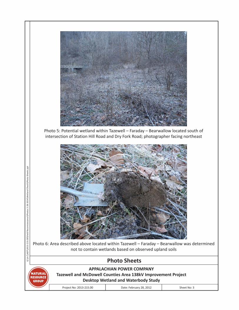
Q:\AC\AE
P\20
1321
5.00\FieldRe
conn
aissance\Pho
tos2
282014\W
etland
Check\Ph
otoSheets.ppt
APPALACHIAN POWER COMPANYTazewell and McDowell Counties Area 138kV Improvement Project
Desktop Wetland and Waterbody StudyProject No: 2013 215.00 Date: February 28, 2012 Sheet No: 3
Photo Sheets
Photo 5: Potential wetland within Tazewell – Faraday – Bearwallow located south ofintersection of Station Hill Road and Dry Fork Road; photographer facing northeast
Photo 6: Area described above located within Tazewell – Faraday – Bearwallow was determinednot to contain wetlands based on observed upland soils
Desktop Wetland and Waterbody Study Tazewell and McDowell Counties Area 138kV Improvement Project
Attachment 4
Graphics Depicting the Spatial Locations of the Analytical Data

Bluefield -Tazewell
138 kV Line
Bearwallow- Jim Branch88 kV Line
Bearwallow -Jewell Branch
69 kV Line
Switchback- Saltville
138 kV Line
McDowell- Tazewell34 kV Line
Bearwallow- Tazewell69 kV Line
Berwind -McDowell34 kV Line
1
10
11
3
4
5
6
78
9
2
Beech Fork
Kewee Creek
Vall Creek
DryFork
War
Cre
ek
Laurel Fork
Jacobs Fork
Middle
Cre ek
IndianC
ree k
South Branch Indian Creek
DixCreek
Hors
epen
Creek
North
Fork
Big
Creek
Ray Fo
rk
JohnsonBranch
North
Branch
Ind ianCreek
JohnyBranch
Cucumber Creek
Jack
son
F ork
Clinch River
Laurel Fork
Cavitts Creek
Greasy Creek
Lewis Fork
12/04
11
9
16/08
9/06
12/06
9/03
9/02
16/07
9
13/04
624
627 626
622
637
631
61
16
Squire
Amonate
TazewellSubstation
BearwallowSubstation
FaradaySubstation
TazewellSubstation
McDowell
Hickory Gap
Red Oak(AP)
AmonateLights
Berwind
Proposed TransmissionLine
Alternative Route
Existing Substation
Proposed Substation
Existing Transmission Line
Stream/River
Town Boundary
County Boundary
Index Page
0 0.5 1
Miles
EW
S
N
1 inch = 5,000 feet
FILE: M:\Clients\A-C\AEP\Tazmac\_ArcGIS\2014\08\Report_Maps_Taze_Bear\AEP_TazMac_Taze_to_Bear_Wetland_Probability_Mapset_Index.mxd | REVISED: 08/19/2014 | SCALE: 1:60,000 when printed at 11x17 DRAWN BY: JPBThis information is for environmental review purposes only.
Virginia
Kentucky
West Virginia
Tennessee North Carolina
Exhibit 4
Wetland ProbabilityMapset
Tazewell - Bearwallow 138 kVTransmission Line
Rebuild ProjectVirginia
Upper
Lower
631
16
Circle Dr
Flee
t Dr
Little Acres Rd
Adira Rd
Waushopper Rd
Mobile D
r
Haw
kins
Rd
Gien Ave
Rayw
ood Dr
Oak Ridge Rd
Mundy Branch
Cavitt
s Cre
ek
Cavitts Creek
TazewellSubstation
TazewellSubstation
Bearwallow to Faraday to Tazewell Station 138 kV LineBearwallow to Faraday toTazewell Alternative 138 kv Line
Existing Substation
Proposed Substation
Proposed SubstationExisting Substation (to beExpanded)
Existing Substation100-Foot Right-of-Way
Stream/RiverNWI Wetlands (VA)
Wetland Cover TypesOpen WaterPalustrine SystemEmergent WetlandPalustrine SystemForested Wetland
Hydric Soils (SSURGO)All hydricPartially hydric
Wetland ProbabilityMedium/HighMediumMedium/LowTown Boundary
County BoundaryState Boundary
0 250 500
Feet
EW
S
N
FILE: M:\Clients\A-C\AEP\Tazmac\_ArcGIS\2014\08\Report_Maps_Taze_Bear\AEP_TazMac_Taze_to_Bear_Wetland_Probability_Mapset.mxd | REVISED: 08/19/2014 | SCALE: 1:6,000 when printed at 11x17 DRAWN BY: JPB
This information is for environmental review purposes only. 1
10
11
3
45
678
9
2VA
WV
TazewellCounty
McDowellCounty
Wetland ProbabilityMapset
Tazewell - Bearwallow 138 kVTransmission Line
Rebuild ProjectVirginia
1 inch equals 500 feet Page 1 of 11
Fred
ricks
burg
Ln
Dead Oak St
Dry Fork
Mundy Branch
Bearwallow to Faraday to Tazewell Station 138 kV LineBearwallow to Faraday toTazewell Alternative 138 kv Line
Existing Substation
Proposed Substation
Proposed SubstationExisting Substation (to beExpanded)
Existing Substation100-Foot Right-of-Way
Stream/RiverNWI Wetlands (VA)
Wetland Cover TypesOpen WaterPalustrine SystemEmergent WetlandPalustrine SystemForested Wetland
Hydric Soils (SSURGO)All hydricPartially hydric
Wetland ProbabilityMedium/HighMediumMedium/LowTown Boundary
County BoundaryState Boundary
0 250 500
Feet
EW
S
N
FILE: M:\Clients\A-C\AEP\Tazmac\_ArcGIS\2014\08\Report_Maps_Taze_Bear\AEP_TazMac_Taze_to_Bear_Wetland_Probability_Mapset.mxd | REVISED: 08/19/2014 | SCALE: 1:6,000 when printed at 11x17 DRAWN BY: JPB
This information is for environmental review purposes only. 1
10
11
3
45
678
9
2VA
WV
TazewellCounty
McDowellCounty
Wetland ProbabilityMapset
Tazewell - Bearwallow 138 kVTransmission Line
Rebuild ProjectVirginia
1 inch equals 500 feet Page 2 of 11
Har
mon
St
Sparks Hollow
Rd
BillsB
ra nc h
Dry Fork
Bearwallow to Faraday to Tazewell Station 138 kV LineBearwallow to Faraday toTazewell Alternative 138 kv Line
Existing Substation
Proposed Substation
Proposed SubstationExisting Substation (to beExpanded)
Existing Substation100-Foot Right-of-Way
Stream/RiverNWI Wetlands (VA)
Wetland Cover TypesOpen WaterPalustrine SystemEmergent WetlandPalustrine SystemForested Wetland
Hydric Soils (SSURGO)All hydricPartially hydric
Wetland ProbabilityMedium/HighMediumMedium/LowTown Boundary
County BoundaryState Boundary
0 250 500
Feet
EW
S
N
FILE: M:\Clients\A-C\AEP\Tazmac\_ArcGIS\2014\08\Report_Maps_Taze_Bear\AEP_TazMac_Taze_to_Bear_Wetland_Probability_Mapset.mxd | REVISED: 08/19/2014 | SCALE: 1:6,000 when printed at 11x17 DRAWN BY: JPB
This information is for environmental review purposes only. 1
10
11
3
45
678
9
2VA
WV
TazewellCounty
McDowellCounty
Wetland ProbabilityMapset
Tazewell - Bearwallow 138 kVTransmission Line
Rebuild ProjectVirginia
1 inch equals 500 feet Page 3 of 11

Harm
on S
t
Dix Creek
Bearwallow to Faraday to Tazewell Station 138 kV LineBearwallow to Faraday toTazewell Alternative 138 kv Line
Existing Substation
Proposed Substation
Proposed SubstationExisting Substation (to beExpanded)
Existing Substation100-Foot Right-of-Way
Stream/RiverNWI Wetlands (VA)
Wetland Cover TypesOpen WaterPalustrine SystemEmergent WetlandPalustrine SystemForested Wetland
Hydric Soils (SSURGO)All hydricPartially hydric
Wetland ProbabilityMedium/HighMediumMedium/LowTown Boundary
County BoundaryState Boundary
0 250 500
Feet
EW
S
N
FILE: M:\Clients\A-C\AEP\Tazmac\_ArcGIS\2014\08\Report_Maps_Taze_Bear\AEP_TazMac_Taze_to_Bear_Wetland_Probability_Mapset.mxd | REVISED: 08/19/2014 | SCALE: 1:6,000 when printed at 11x17 DRAWN BY: JPB
This information is for environmental review purposes only. 1
10
11
3
45
678
9
2VA
WV
TazewellCounty
McDowellCounty
Wetland ProbabilityMapset
Tazewell - Bearwallow 138 kVTransmission Line
Rebuild ProjectVirginia
1 inch equals 500 feet Page 4 of 11
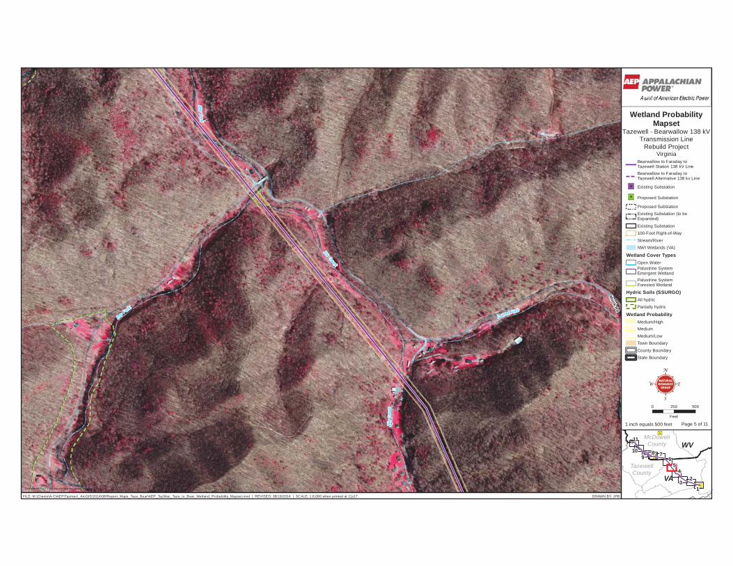
Monk Rd
Dix Creek
Dry
F ork
Di x
Cre
ek
Dry Fork
Laurel Fork
Bearwallow to Faraday to Tazewell Station 138 kV LineBearwallow to Faraday toTazewell Alternative 138 kv Line
Existing Substation
Proposed Substation
Proposed SubstationExisting Substation (to beExpanded)
Existing Substation100-Foot Right-of-Way
Stream/RiverNWI Wetlands (VA)
Wetland Cover TypesOpen WaterPalustrine SystemEmergent WetlandPalustrine SystemForested Wetland
Hydric Soils (SSURGO)All hydricPartially hydric
Wetland ProbabilityMedium/HighMediumMedium/LowTown Boundary
County BoundaryState Boundary
0 250 500
Feet
EW
S
N
FILE: M:\Clients\A-C\AEP\Tazmac\_ArcGIS\2014\08\Report_Maps_Taze_Bear\AEP_TazMac_Taze_to_Bear_Wetland_Probability_Mapset.mxd | REVISED: 08/19/2014 | SCALE: 1:6,000 when printed at 11x17 DRAWN BY: JPB
This information is for environmental review purposes only. 1
10
11
3
45
678
9
2VA
WV
TazewellCounty
McDowellCounty
Wetland ProbabilityMapset
Tazewell - Bearwallow 138 kVTransmission Line
Rebuild ProjectVirginia
1 inch equals 500 feet Page 5 of 11
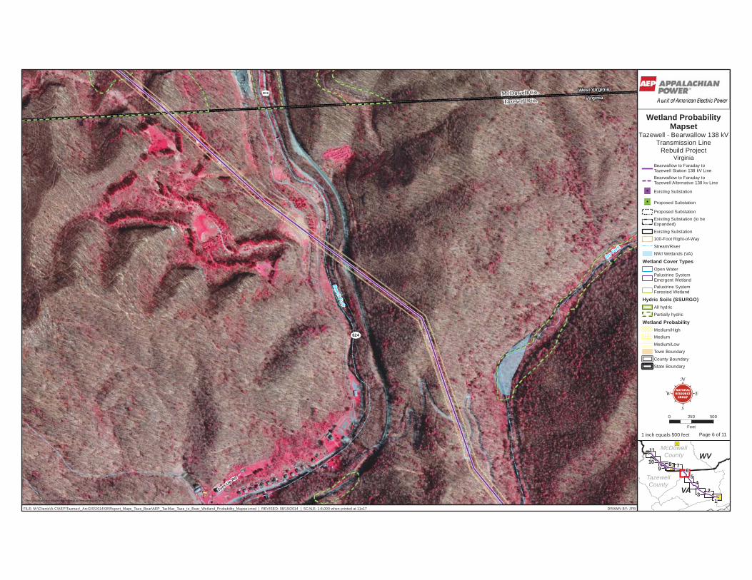
9/06
624
Turn Up Rd
Dry Fork
Beech Fork
Tazewell Co.McDowell Co.
VirginiaWest Virginia
Bearwallow to Faraday to Tazewell Station 138 kV LineBearwallow to Faraday toTazewell Alternative 138 kv Line
Existing Substation
Proposed Substation
Proposed SubstationExisting Substation (to beExpanded)
Existing Substation100-Foot Right-of-Way
Stream/RiverNWI Wetlands (VA)
Wetland Cover TypesOpen WaterPalustrine SystemEmergent WetlandPalustrine SystemForested Wetland
Hydric Soils (SSURGO)All hydricPartially hydric
Wetland ProbabilityMedium/HighMediumMedium/LowTown Boundary
County BoundaryState Boundary
0 250 500
Feet
EW
S
N
FILE: M:\Clients\A-C\AEP\Tazmac\_ArcGIS\2014\08\Report_Maps_Taze_Bear\AEP_TazMac_Taze_to_Bear_Wetland_Probability_Mapset.mxd | REVISED: 08/19/2014 | SCALE: 1:6,000 when printed at 11x17 DRAWN BY: JPB
This information is for environmental review purposes only. 1
10
11
3
45
678
9
2VA
WV
TazewellCounty
McDowellCounty
Wetland ProbabilityMapset
Tazewell - Bearwallow 138 kVTransmission Line
Rebuild ProjectVirginia
1 inch equals 500 feet Page 6 of 11
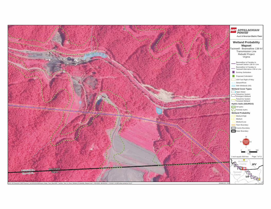
Tazewell Co.McDowell Co.
VirginiaWest Virginia
Bearwallow to Faraday to Tazewell Station 138 kV LineBearwallow to Faraday toTazewell Alternative 138 kv Line
Existing Substation
Proposed Substation
100-Foot Right-of-Way
Stream/River
NWI Wetlands (VA)
Wetland Cover TypesOpen WaterPalustrine SystemEmergent WetlandPalustrine SystemForested Wetland
Hydric Soils (SSURGO)All hydric
Partially hydric
Wetland ProbabilityMedium/High
Medium
Medium/Low
Town Boundary
County Boundary
State Boundary
0 250 500
Feet
EW
S
N
FILE: M:\Clients\A-C\AEP\Tazmac\_ArcGIS\2014\08\Report_Maps_Taze_Bear\AEP_TazMac_Taze_to_Bear_Wetland_Probability_Mapset.mxd | REVISED: 08/19/2014 | SCALE: 1:6,000 when printed at 11x17 DRAWN BY: JPB
This information is for environmental review purposes only. 1
10
11
3
45
678
9
2VA
WV
TazewellCounty
McDowellCounty
Wetland ProbabilityMapset
Tazewell - Bearwallow 138 kVTransmission Line
Rebuild ProjectVirginia
1 inch equals 500 feet Page 7 of 11

9/02
Tazewell C
o.M
cDow
e llCo .
VirginiaW
est Virgini a
FaradaySubstation
Bearwallow to Faraday to Tazewell Station 138 kV LineBearwallow to Faraday toTazewell Alternative 138 kv Line
Existing Substation
Proposed Substation
100-Foot Right-of-Way
Stream/River
NWI Wetlands (VA)
Wetland Cover TypesOpen WaterPalustrine SystemEmergent WetlandPalustrine SystemForested Wetland
Hydric Soils (SSURGO)All hydric
Partially hydric
Wetland ProbabilityMedium/High
Medium
Medium/Low
Town Boundary
County Boundary
State Boundary
0 250 500
Feet
EW
S
N
FILE: M:\Clients\A-C\AEP\Tazmac\_ArcGIS\2014\08\Report_Maps_Taze_Bear\AEP_TazMac_Taze_to_Bear_Wetland_Probability_Mapset.mxd | REVISED: 08/19/2014 | SCALE: 1:6,000 when printed at 11x17 DRAWN BY: JPB
This information is for environmental review purposes only. 1
10
11
3
45
678
9
2VA
WV
TazewellCounty
McDowellCounty
Wetland ProbabilityMapset
Tazewell - Bearwallow 138 kVTransmission Line
Rebuild ProjectVirginia
1 inch equals 500 feet Page 8 of 11
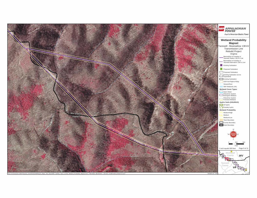
9/02
Virginia
West Virginia
Bearwallow to Faraday to Tazewell Station 138 kV LineBearwallow to Faraday toTazewell Alternative 138 kv Line
Existing Substation
Proposed Substation
Proposed SubstationExisting Substation (to beExpanded)
Existing Substation100-Foot Right-of-Way
Stream/RiverNWI Wetlands (VA)
Wetland Cover TypesOpen WaterPalustrine SystemEmergent WetlandPalustrine SystemForested Wetland
Hydric Soils (SSURGO)All hydricPartially hydric
Wetland ProbabilityMedium/HighMediumMedium/LowTown Boundary
County BoundaryState Boundary
0 250 500
Feet
EW
S
N
FILE: M:\Clients\A-C\AEP\Tazmac\_ArcGIS\2014\08\Report_Maps_Taze_Bear\AEP_TazMac_Taze_to_Bear_Wetland_Probability_Mapset.mxd | REVISED: 08/19/2014 | SCALE: 1:6,000 when printed at 11x17 DRAWN BY: JPB
This information is for environmental review purposes only. 1
10
11
3
45
678
9
2VA
WV
TazewellCounty
McDowellCounty
Wetland ProbabilityMapset
Tazewell - Bearwallow 138 kVTransmission Line
Rebuild ProjectVirginia
1 inch equals 500 feet Page 9 of 11
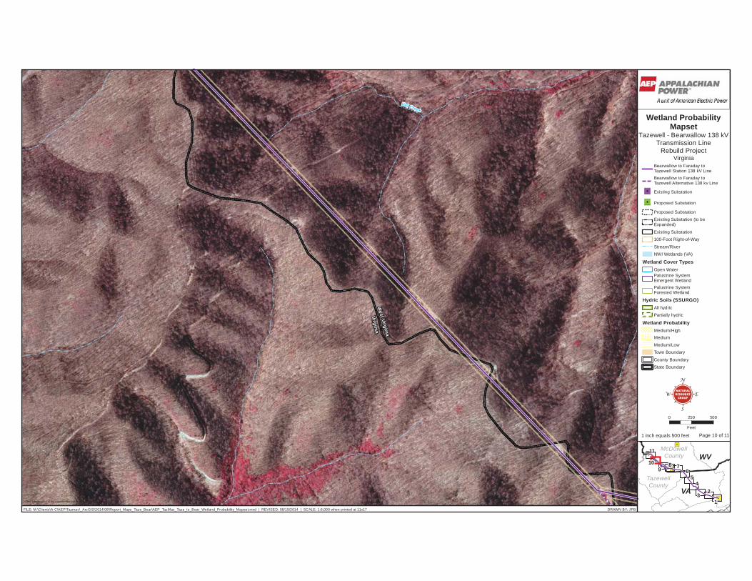
Vall Creek
VirginiaW
est Virginia
Bearwallow to Faraday to Tazewell Station 138 kV LineBearwallow to Faraday toTazewell Alternative 138 kv Line
Existing Substation
Proposed Substation
Proposed SubstationExisting Substation (to beExpanded)
Existing Substation100-Foot Right-of-Way
Stream/RiverNWI Wetlands (VA)
Wetland Cover TypesOpen WaterPalustrine SystemEmergent WetlandPalustrine SystemForested Wetland
Hydric Soils (SSURGO)All hydricPartially hydric
Wetland ProbabilityMedium/HighMediumMedium/LowTown Boundary
County BoundaryState Boundary
0 250 500
Feet
EW
S
N
FILE: M:\Clients\A-C\AEP\Tazmac\_ArcGIS\2014\08\Report_Maps_Taze_Bear\AEP_TazMac_Taze_to_Bear_Wetland_Probability_Mapset.mxd | REVISED: 08/19/2014 | SCALE: 1:6,000 when printed at 11x17 DRAWN BY: JPB
This information is for environmental review purposes only. 1
10
11
3
45
678
9
2VA
WV
TazewellCounty
McDowellCounty
Wetland ProbabilityMapset
Tazewell - Bearwallow 138 kVTransmission Line
Rebuild ProjectVirginia
1 inch equals 500 feet Page 10 of 11

Kewee Creek
Vall Creek
War
Cree
k
NorthBranch
IndianCreek
VirginiaW
est Virgin ia
BearwallowSubstation
Bearwallow to Faraday to Tazewell Station 138 kV LineBearwallow to Faraday toTazewell Alternative 138 kv Line
Existing Substation
Proposed Substation
Proposed SubstationExisting Substation (to beExpanded)
Existing Substation100-Foot Right-of-Way
Stream/RiverNWI Wetlands (VA)
Wetland Cover TypesOpen WaterPalustrine SystemEmergent WetlandPalustrine SystemForested Wetland
Hydric Soils (SSURGO)All hydricPartially hydric
Wetland ProbabilityMedium/HighMediumMedium/LowTown Boundary
County BoundaryState Boundary
0 250 500
Feet
EW
S
N
FILE: M:\Clients\A-C\AEP\Tazmac\_ArcGIS\2014\08\Report_Maps_Taze_Bear\AEP_TazMac_Taze_to_Bear_Wetland_Probability_Mapset.mxd | REVISED: 08/19/2014 | SCALE: 1:6,000 when printed at 11x17 DRAWN BY: JPB
This information is for environmental review purposes only. 1
10
11
3
45
678
9
2VA
WV
TazewellCounty
McDowellCounty
Wetland ProbabilityMapset
Tazewell - Bearwallow 138 kVTransmission Line
Rebuild ProjectVirginia
1 inch equals 500 feet Page 11 of 11