appendix j preliminary contamination assessment on stockpiled...
TRANSCRIPT

REPORT ON PRELIMINARY CONTAMINATION ASSESSMENT ON STOCKPILED MATERIAL AND GENERAL LAND QUALITY LIGHT HORSE BUSINESS CENTRE (LHBC) QUARRY ROAD EASTERN CREEK Prepared for DIAL A PRODUCT PTY LTD Project 43756A April 2006

REPORT ON PRELIMINARY CONTAMINATION ASSESSMENT ON STOCKPILED MATERIAL AND GENERAL LAND QUALITY LIGHT HORSE BUSINESS CENTRE (LHBC) QUARRY ROAD EASTERN CREEK Prepared for DIAL A PRODUCT PTY LTD Project 43756A April 2006
Douglas Partners Pty Ltd ABN 75 053 980 117
96 Hermitage Road West Ryde NSW 2114 Australia
PO Box 472 West Ryde NSW 1685 Phone (02) 9809 0666 Fax (02) 9809 4095 [email protected]

EXECUTIVE SUMMARY This report details the methodology and results of a Preliminary Contamination Assessment of Stockpiled Material conducted by Douglas Partners Pty Ltd (DP) at Quarry Road, Eastern Creek, New South Wales. The subject site, Site A, is a 15 ha sub-section of a larger site owned by Dial A Product Pty Ltd (Site B), which includes Hanson Quarry (formerly Pioneer Quarry). Site A is overlain with an overburden stockpile material from the quarry. It is understood that this material is to be removed from the site and the area subdivided into allotments for commercial/ industrial land-use.
A review of available site history and previous environmental reports undertaken by others
indicates that Site A and the surrounding area was used for agricultural purposes prior to
the development of the quarry in the 1950’s. By 1970 an extensive quarry pit had been
excavated to the east of the site and office buildings, plants and stockpiled material were
located to the south of the quarry. A significant volume of overburden, presumably from the
quarry, had been placed on the northern portion of Site A. By 1986 the stockpile had been
extended to the southern portion of Site A.
An excavator was used to excavate twenty one test pits at the site. Test pits at Locations 1
to 16 and 21 were in stockpiled material and those at Locations 17-20 were in natural in-situ
material along the western portion of the subject site. The stockpiled material sourced as
Virgin Excavated Natural Material (VENM) from the quarry area typically comprised grey-
black ripped sandstone and mudstone filling, cobble and boulder inclusions and brown
gravely clay filling with sandstone cobble inclusions. The in-situ natural material comprised
brown silty top soil underlain by silty clay with some ironstone gravel.
The analytical results indicate that the heavy metal and PAH concentrations of the
overburden stockpile material are within Australian background ranges. It is noted that one
sample (15/0.8-1.0) recorded a concentration of nickel (100 mg/kg) above the NSW DEC
provisional phototoxicity-based investigation levels (60 mg/kg), but within the DEC Health
based investigation levels for residential use (600 mg/kg). The observed nickel
concentration is consistent with those in materials collected from the adjacent quarry in a
previous investigation undertaken by ADI (1998). In addition, it is noted that nickel is a

common element in basic igneous rocks with local dolerites understood to have levels >360
mg/kg, with chromium, >550 mg/kg, and copper >100 mg/kg.
The analytical results were found to be below the adopted threshold criteria for both the
stockpile and the in-situ materials. On this basis, the stockpiled material can be considered
to be VENM and is considered suitable for off-site re-use as fill. However, the assessment
of the stockpile was limited to the top 2.8 m of the stockpile and accordingly if material
different to that described in the test pit logs, or if material showing signs of contamination
(identified by odours, stains, or anthropogenic inclusions) is encountered additional testing
shall be required. Not withstanding, it is recommended that additional samples are
collected and analysed on a regular basis (and prior to removal) as the stockpile is
progressively excavated for any off site re-use.
The preliminary analysis of in-situ material indicates that the site is suitable for commercial/
industrial use. However, following the removal of the stockpiled material it is recommended
that additional field work and laboratory analysis and reporting are undertaken to a level
commensurate with the site area intended for redevelopment and according to relevant
published guidelines.
Preliminary Contamination Assessment of Stockpiled Material and General Land Quality Project 43756A Light Horse Business Centre April 2006 Quarry Road, Eastern Creek
TABLE OF CONTENTS Page 1. INTRODUCTION .................................................................................................. 1 2. SCOPE OF WORKS ............................................................................................ 2 3. SITE DESCRIPTION ............................................................................................ 3
3.1 Site Location ............................................................................................. 3 3.2 Site Description ........................................................................................ 4
3.3 Proposed Development ............................................................................ 4 4. REGIONAL GEOLOGY AND HYDROGEOLOGY ............................................... 5 5. SITE HISTORY ................................................................................................... 6
5.1 Title Deeds ............................................................................................... 6 5.2 Aerial Photographs ................................................................................... 6 5.3 Regulatory Notices Search ....................................................................... 8 5.4 Blacktown City Council Section 149(2) Certificate ................................... 9
6. REVIEW OF PREVIOUS INVESTIGATIONS ...................................................... 9 6.1 Stage 1 Environmental Assessment of Pioneer Concrete
(NSW) Wallgrove Quarry, December 1994 by Australian Defence Industries Services (ADI Services). ............................................ 10
6.2 Stage 2 Environmental Assessment of Areas 1 and 3 Wallgrove Quarry, March 1995, by Australian Defence Industries Services (ADI Services). .......................................................... 11
6.3 Stage 3 Environmental Assessment of Pioneer Concrete (NSW) Wallgrove Quarry, April 1998 by Australian Defence Industries Services (ADI Services). .......................................................... 12
6.4 Phase 1 Investigation for Lot 2 (DP262213), Archbold Road, Eastern Creek, NSW, October 2004 by CH2M Hill Australia Pty Ltd (CH2MHILL) ................................................................................. 13
6.5 Lot 2 Deposit Plan (DP)262213 Archbold Road, Eastern Creek, NSW – Review of Previous Environmental Reports, December 2004, Environmental Resources Management Australia (ERM). ....................................................................................... 14
7. POTENTIAL CONTAMINANTS ............................................................................ 14 8. ASSESSMENT CRITERIA ................................................................................... 15
8.1 Site Assessment Criteria .......................................................................... 15 9. FIELD INVESTIGATION ...................................................................................... 17
9.1 Sample Location Rationale ....................................................................... 17 9.2 Sampling Methodology ............................................................................. 17 9.3 Analytical Rationale .................................................................................. 18

Preliminary Contamination Assessment of Stockpiled Material and General Land Quality Project 43756A Light Horse Business Centre April 2006 Quarry Road, Eastern Creek
TABLE OF CONTENTS
Page
10. RESULTS OF INVESTIGATION .......................................................................... 19 10.1 Field Observations .................................................................................... 19 10.2 Total Photoionisable Compounds (TOPIC) Results ................................. 21 10.3 Laboratory Analysis ................................................................................. 21
10.3.1 Results of Laboratory Analysis .................................................. 21 10.4 QA/QC Procedures and Results ............................................................... 25
11. DISCUSSION ................................................................................................... 25 11.1 Review of Available Site History Information ............................................ 25 11.2 Overburden Stockpile Assessment .......................................................... 27 11.3 Preliminary Assessment of In-situ material .............................................. 27
12. CONCLUSIONS ................................................................................................... 28 13. LIMITATIONS OF THIS REPORT ........................................................................ 28
APPENDIX A: Notes Relating to this Report, Site Plan and Photographs APPENDIX B: DNR Groundwater Bore Search APPENDIX C: Title Deed Search Records APPENDIX D: Aerial Photographs APPENDIX E: Section 149 Planning Certificate APPENDIX F: ADI 1994 – Site Plan Areas 1-3 APPENDIX G: Test Bore Report Sheets APPENDIX H: Laboratory Results APPENDIX I: Quality Assurance/Quality Control Procedures and Results

Page 1 of 29
Preliminary Contamination Assessment of Stockpiled Material and General Land Quality Project 43756A Light Horse Business Centre April 2006 Quarry Road, Eastern Creek
CFK:jlb
Project 43756A
7 April 2006
REPORT ON
PRELIMINARY CONTAMINATION ASSESSMENT OF STOCKPILED MATERIAL AND GENERAL LAND QUALITY
QUARRY ROAD, EASTERN CREEK
1. INTRODUCTION
This report details the methodology and results of a Preliminary Contamination Assessment of Stockpiled Material conducted by Douglas Partners Pty Ltd (DP) at Archbold Road, Eastern Creek, New South Wales. The investigation was commissioned by Mr Ian Malouf of Dial A Product Pty Ltd. The subject site, Site A, is a 15 ha sub-section of a larger site owned by Dial A Product Pty Ltd (Site B), which includes Hanson Quarry (formerly Pioneer Quarry). Site A is overlain with an overburden stockpile material from the quarry. It is understood that this material is to be removed from the site and the area subdivided into allotments for commercial/ industrial land-use. The scope of the current assessment was to:
• Conduct a site history review; and
• Sample and analyse the in-situ sub-soils and the stockpile at a total of 21 locations. A
detailed scope of works is provided in Section 2.
The objective of the Preliminary Assessment was to provide advice on the quality of the
stockpiled material for re-use on or off the site and the suitability of the site for commercial
use.

Page 2 of 29
Preliminary Contamination Assessment of Stockpiled Material and General Land Quality Project 43756A Light Horse Business Centre April 2006 Quarry Road, Eastern Creek
The current investigation has been carried out concurrently with a geotechnical
investigation. The geotechnical findings are reported separately in a Report on
Geotechnical Investigation, March 2006 by DP (Project 43756).
2. SCOPE OF WORKS
The scope of the current assessment comprised the following: -
• Undertake a site history search including a review of historical aerial photograph
records, historical title deeds, Council records (s149(2)) certificate and a search of the
NSW Department of Environment and Conservation (DEC) register for Notices issued
under the Contaminated Land Management Act;
• Review available environmental information with reference to local soils and geology.
Obtain and review Department of Natural Resources (DNR) groundwater bore records
for the surrounding area (1 km);
• Review previous environmental investigations undertaken on the site;
• Excavate twenty one shallow test pits, using an excavator to a depth of 2.0 -3.0 m.
Collect soil/filling samples at nominal depths of 0.3 - 0.5 m, 0.8 - 1.0 m and 1.8 - 2.0 m,
or at signs of contamination. An additional 10% duplicates were collected for quality
assurance and quality control (QA/ QC) requirements;
• Screen all samples collected with a photoionisation detector (PID) to detect the
presence of volatile organic compounds;
• Conduct laboratory analysis on 26 selected samples (including 10% QA/ QC) at a NATA
accredited analytical laboratory for a combination of the following potential
contaminants:
- Heavy metals (As, Cd, Cr, Cu, Pb, Hg, Ni, Zn);
- Petroleum hydrocarbons (TPH) and mono - aromatic hydrocarbons (BTEX);
- Polycyclic Aromatic Hydrocarbons (PAH);
- Polychlorinated Biphenyls (PCB);
- Organochlorine Pesticides (OCP);
- Organophosphate Pesticides (OPP); and

Page 3 of 29
Preliminary Contamination Assessment of Stockpiled Material and General Land Quality Project 43756A Light Horse Business Centre April 2006 Quarry Road, Eastern Creek
- Phenols.
• Store remaining soil samples not analysed for a period of one month pending the need
for further analysis;
• Completion of a Preliminary Contamination Assessment Report, providing general
comments on:
- the level of contamination in the insitu subsoils and stockpile,
- the likely suitability of the site for commercial use; and
- the quality of the stockpiled material for re-use on or off the site.
The scope of the site assessment activities and consulting services undertaken by DP were
limited to those detailed in the proposal dated 20 January 2006 and by the accompanying
conditions of engagement.
3. SITE DESCRIPTION
3.1 Site Location
The property is located on Archbold Road, Eastern Creek. It is approximately 15 ha in area
and is located in the local government area of Blacktown. The site forms a portion of Lot 2
DP 262213 within the Parish of Melville, County of Cumberland.
The surrounding area is largely agricultural, with some industrial site use. The M4
Motorway is located to the north of the site and the former Australia’s Wonderland site is
located to the east. A site location map and site plan is provided as Appendix A.

Page 4 of 29
Preliminary Contamination Assessment of Stockpiled Material and General Land Quality Project 43756A Light Horse Business Centre April 2006 Quarry Road, Eastern Creek
3.2 Site Description
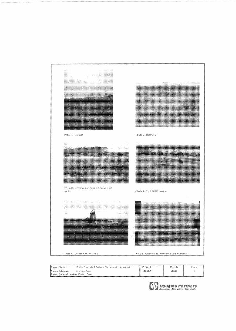
The site is a roughly rectangular shaped land parcel located in the south-west corner of the larger Dial A Product Pty Ltd site. The site fronts Archbold Road to the west and a quarry pit is located to the east. A stand of remnant bushland is located to the north of the site. The majority of the site is overlain by a large stockpile estimated to comprise in excess of 1 million m3 of material originally sourced from the quarry. The overburden stockpile is 30 m in height and is vegetated with grasses. It is understood that the material from the quarry was excavated as Virgin Excavated Natural Material (VENM) and transported directly to the overburden stockpile for storage. On this basis, the material is described as VENM sourced material. The remaining portion of the site, fronting Archbold Road, is vegetated with grasses and scattered trees. An unsealed road provides access around the stockpile and on top of stockpile. An old explosives bunker with a bituminous concrete slab is located on the eastern portion of the stockpile. It is understood that this area was used to store fertilisers for the explosives required as part of the adjacent quarry operation. A site plan is provided as Drawing 1 (Appendix A). Selected photographs of the site are
attached in Appendix A.
3.3 Proposed Development
It is understood that the overburden stockpile is to be excavated and exported off-site to the nearby Austral bricks site, and the area subdivided into allotments for commercial / industrial land-use. Details are not known at this stage.

Page 5 of 29
Preliminary Contamination Assessment of Stockpiled Material and General Land Quality Project 43756A Light Horse Business Centre April 2006 Quarry Road, Eastern Creek
4. REGIONAL GEOLOGY AND HYDROGEOLOGY
Reference to the Sydney 1:100 000 Geological Series Sheet indicates the site is underlain
by Bringelly Shale from the Wianamatta Group. Bringelly Shale generally comprises shale,
carbonaceous claystone, claystone, laminate, fine to medium grain lithic sandstone and rare
coal. The adjacent quarry is found in an intrusive (igneous) plug of dolerite and breccia
rocks which may have caused localised metamorphism of the shale rocks.
Groundwater was not encountered during the current investigation. Given the close
proximity to the adjacent quarry which is understood to extend approximately 180 m below
the surrounding ground level, it is considered that groundwater beneath the site would be at
significant depth and flow eastward into the quarry. It is likely that groundwater levels would
have been significantly lowered due to quarrying activities.
A NSW Department of Natural Resources (DNR, formerly Department of Land and Water
Conservation) groundwater bore search was conducted for the site on 21 February 2006
(Table 1). The DNR bore search results are provided in Appendix B. Nine bores have
been constructed within a radius of 4 km from the site for a variety of authorised purposes
and proposed uses included aquaculture, irrigation, monitoring and waste disposal. The
final depth of the bores varied from 6.0 to 217.9 m below ground level. Information
regarding groundwater occurrence was available for only three of the bores in which the
standing water level was measured between 2.10 to 33.5 m below ground level.
Table 1 – Summary of Groundwater Bores
Groundwater Bore
Standing Water Level
(bgl) (m) Depth of Bore (m)
Water Quality
Purpose Of Bore
Authorized Intended
GW018361 33.50 217.9 - Aquaculture/ Waste disposal
Waste Disposal
GW028414 3.90 6.00 - Irrigation Irrigation GW028415 2.10 7.60 Brackish Irrigation Irrigation GW101082 - 40.30 - Monitoring bore Test bore GW101085 - 99.30 - Monitoring bore Test bore GW101086 - 69.70 - Monitoring bore Test bore GW102674 - 69.70 Brackish
(4,400 mg/ L salinity)
Monitoring bore Test bore
GW103953 - 9.90 - Monitoring bore Monitoring bore GW103954 - 9.90 - Monitoring bore Monitoring bore

Page 6 of 29
Preliminary Contamination Assessment of Stockpiled Material and General Land Quality Project 43756A Light Horse Business Centre April 2006 Quarry Road, Eastern Creek
5. SITE HISTORY
5.1 Title Deeds
A 100-year historical land title deed search of the site was conducted at the Lands Title
Office (LTO). Determination of the ownership or occupancy of the property, including
company names, can assist in the identification of previous land uses and therefore
establish potentially contaminating activities.
A summary of the records with the owner/occupier details and the possible site uses is
presented in Table 2. The full title deed records and the Deposit Plan for the site are
included in Appendix C.
Table 2 – Summary of Title Deed Search
Date Owner/ Occupier Occupation Possible Site Use Identifier
As to that part marked 1 on the attached cadastre
06.12.1909 Thomas Baker Tanner Agricultural Book 895 No. 803
03.05.1955 Burfield Pty Limited (Now Ray Fitzpatrick Pty Limited) Quarry 2/ 262213
As to those parts marked 2 & 3 on the attached cadastre 09.03.1917 Elizabeth Sarah Baker Married Woman Agricultural Book 1102 No. 994 29.08.1946 William Thomas Gillett Baker Grazier Agricultural Book 1995 No. 998
03.05.1955 Burfield Pty Limited (Now Ray Fitzpatrick Pty Limited) Quarry 2/ 262213
Search continued as to the whole of the subject land 12.09.2005 # ACN 114 843 453 Pty Limited Quarry 2/ 262213
# Current Registered Proprietor
5.2 Aerial Photographs
Aerial photographs from 1947, 1951, 1970, 1986, and 2002 were obtained from the NSW
Department of Lands Office. The aerial photographs are presented in Appendix D. These
aerial photos were studied to determine the likely past uses of the site, particularly those of
a potentially contaminating nature. The findings are summarised below.
1947 Aerial Photograph: The subject site, Site A, and the majority of the surrounding area
was open grassland, indicating agricultural land use. To the north of the subject site, land
had been cleared of native vegetation and sub-divided into paddocks that had been tilled. A

Page 7 of 29
Preliminary Contamination Assessment of Stockpiled Material and General Land Quality Project 43756A Light Horse Business Centre April 2006 Quarry Road, Eastern Creek
small stand of remnant woodland was located adjacent to the northern portion of Site A. A
small creek is located to the south of the site orientated from south-east to the north-west
toward Ropes Creek in the west. Local infrastructure included present day Archbold Road
to the west of the site and The Great Western Highway to the north. A number of small
residential farm buildings are also present in the surrounding area.
1970 Aerial Photograph: The adjacent site to the east had commenced open-cut quarry
operations by this time. A large pit had been excavated and infrastructure including office
buildings, plant and extensive stockpiles were located to the south of the quarry area
(current location of an asphalt plant). The northern half of subject site, Site A, had been
overlain with a large stockpile of material excavated from the quarry. A drainage pathway is
visible from the stockpiled material flowing in a westerly direction from the site. Two small
shed style buildings were present to the south of the stockpile. A bund-like wall,
constructed of soil and rock, surrounded the sheds; it is considered that these sheds may
have been used for storage of explosives. The surrounding area remained agricultural at
this time.
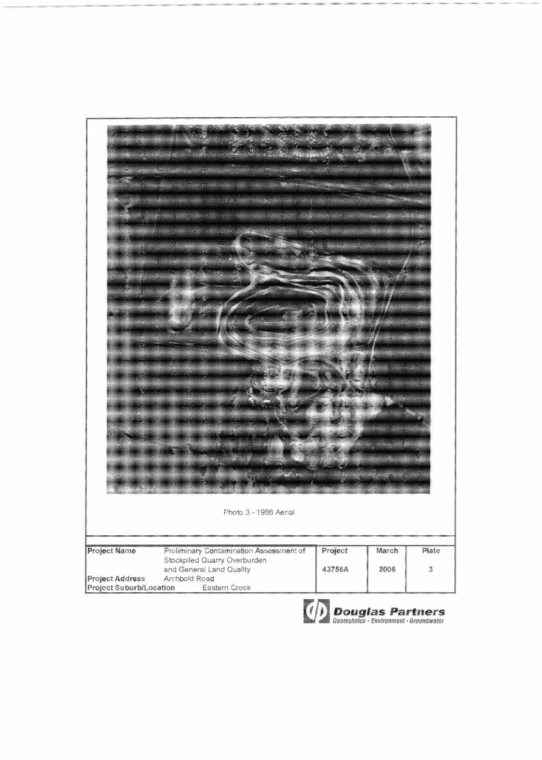
1986 Aerial Photograph: The quarry located to the east of the site had been extended
laterally and vertically from the 1970 aerial photograph. The present day asphalt plant is
present to the south of the quarry. The footprint of the overburden stockpile material
located on Site A had also been expanded to the southern portion of the site. Four sheds
were present on the stockpile with bund-like walls of soil and rock surrounding the
perimeter, possibly used for the storage of explosives for quarry operations. Two larger
sheds had been developed to the north-east of the stockpile. The small pocket of remnant
woodland located to the north of the subject site remained unchanged at this time. The M4
Motorway had been constructed by this time, running in an east west direction to the north
of the site. To the north of the M4 a residential area had been developed, whilst to the
north-west earthworks had been undertaken for the development of a commercial/ industrial
area.
2002 Aerial Photograph: The subject site appeared to relatively unchanged at this time. The
four sheds noted in 1986 aerial photograph had been removed from the stockpile. The
surrounding area remained relatively unchanged. The area to the north-west of the site had
been developed as a commercial/ industrial area.

Page 8 of 29
Preliminary Contamination Assessment of Stockpiled Material and General Land Quality Project 43756A Light Horse Business Centre April 2006 Quarry Road, Eastern Creek
5.3 Regulatory Notices Search
Public Register – Protection of the Environment Operations Act, 1997
Hanson Construction Material is currently licensed by the DEC to undertake Concrete
Batching and hard-rock gravel quarrying at the site (licence number 5073). The licence
details monitoring requirements and acceptable limits for discharges to land and water. It is
noted that a pollution reduction program has been undertaken to reduce the Total
Suspended Solids and pH of water that is discharged from the site.
The DEC has registered four notices and one non-conformance for the site summarised
below:
- Non-conformance on 12/10/2001. Related to two blasts that exceeded over-pressure
levels;
- Notice of Licence Variation (1025278), 27/06/2003. Variation of licence to include
concrete batching plant;
- Notice of Licence Variation (1028667), 12/11/03. References to the EPA changed to
DEC;
- Notice of Licence Variation (103853) 18/06/2004. The licensee requested that the
monitoring requirements for the ‘final dam’ be changed from weekly to monthly. This
change was accepted by the DEC;
- Notice of Licence Variation (1041638) 26/11/2004. The licensee requested an extension
of the monitoring period to obtain information regarding wet weather overflow data, part
of a pollution reduction programme. The licensee was required to further monitor water
in the dam.
Pioneer Road Services, located to the south-west of Site A, is licensed by the DEC (licence
number 494) to undertake bitumen pre-mix or hot mix production and crushing, grinding or
separating works at the asphalt plant. No notices or non-compliances have been issued
under this licence.

Page 9 of 29
Preliminary Contamination Assessment of Stockpiled Material and General Land Quality Project 43756A Light Horse Business Centre April 2006 Quarry Road, Eastern Creek
Public Register – Contaminated Land Management Act, 1997 No Notices or Orders to investigate or remediate have been issued for the site under the
Contaminated Land Management Act, 1997.
5.4 Blacktown City Council Section 149(2) Certificate
The Section 149 Planning Certificate for the site issued by Blacktown City Council was
reviewed as part of this assessment and is provided in Appendix E. There are no notices
issued on the site under the Contaminated Land Management Act, 1997.
6. REVIEW OF PREVIOUS INVESTIGATIONS
A number of environmental investigations have been undertaken on Lot 2 in DP 262213.
Initially a series of three studies were conducted by ADI Services for Environmental
Management Australia Pty Ltd on behalf of Ray Fitzpatrick Pty Ltd. For convenience, ADI
Services divided the entire site (Lot 2 DP262213) into three areas; viz. Area 1 (northern
portion - woodland / forested region), Area 2 (Central portion stockpile and western portion
of the quarry) and Area 3 (southern portion – open grassland) (Appendix F). The subject
site, Site A, is located within Area 2. The following environmental reports have been
prepared by ADI:
- Stage 1 Environmental Assessment of Pioneer Concrete (NSW) Wallgrove Quarry,
December 1994 by Australian Defence Industries Services (ADI Services);
- Stage 2 Environmental Assessment of Areas 1 and 3 Wallgrove Quarry, March 1994, by
Australian Defence Industries Services (ADI Services); and
- Stage 3 Environmental Assessment of Pioneer Concrete (NSW) Wallgrove Quarry, April
1998 by Australian Defence Industries Services (ADI Services).
Page 10 of 29
Preliminary Contamination Assessment of Stockpiled Material and General Land Quality Project 43756A Light Horse Business Centre April 2006 Quarry Road, Eastern Creek
In addition, other consultants prepared a Phase 1 (desktop) Investigation and a Review of
Previous Environmental Reports on Lot 2 DP 262213 which were completed in 2004, and
are listed below.
- Phase 1 Investigation for Lot 2 (DP262213), Archbold Road, Eastern Creek, NSW,
October 2004 by CH2M Hill Australia Pty Ltd (CH2MHILL); and
- Lot 2 Deposit Plan (DP) 262213 Archbold Road, Eastern Creek, NSW – Review of
Previous Environmental Reports, December 2004, Environmental Resources
Management Australia (ERM).
It is noted that the assessments focused on the whole of Lot 2 DP 262213, whilst this report
is concerned with a 15 ha portion of the Lot located in the central west of the site fronting
Archbold Road. A summary of the previous investigations is presented in the following
sections.
6.1 Stage 1 Environmental Assessment of Pioneer Concrete (NSW) Wallgrove Quarry, December 1994 by Australian Defence Industries Services (ADI Services).
The report focused on Areas 1 and 3 located to the north and south of the subject site (Site A). A review of the report revealed:
• That the property had been used as grazing land, as a quarry for road base material and
a portion of the site has been used as an asphalt plant;
• A number of potentially contaminated areas were identified, including areas affected by
runoff from the quarry overburden stockpile (located on Site A) and the asphalt
stockpiles and fines discharged from the dewatering basin into drainage lines, creeks
and the local groundwater;
• Settled fines from the dewatering basin were typically disposed to landfill, however, it is
noted that this material may have been disposed on the overburden stockpile at times;
and

Page 11 of 29
Preliminary Contamination Assessment of Stockpiled Material and General Land Quality Project 43756A Light Horse Business Centre April 2006 Quarry Road, Eastern Creek
• The potential contaminants identified were heavy metals, oils, bitumen, lime, flocculants,
cleaning agents, fuels, petroleum hydrocarbons, and PAHs.
A sampling regime was recommended by ADI to assess whether the identified receptors
within Area 1 and 3 had been contaminated by Pioneer operations in Area 2.
6.2 Stage 2 Environmental Assessment of Areas 1 and 3 Wallgrove Quarry,
March 1995, by Australian Defence Industries Services (ADI Services).
The Stage 2 assessment comprised the sampling regime recommended by ADI in the
Stage 1 assessment. The sampling regime included the collection and laboratory analysis
of soil/sediment from dams, drainage lines and creeks that were identified in the Stage 1
assessment as potential receptors of contaminated material due to quarry and asphalt plant
operations. A number of ‘background’ sediment samples were also collected. In addition
groundwater monitoring wells were installed to assess groundwater contamination.
The findings of the Stage 2 Investigation include:
• Sediment samples collected from the drainage lines (sourced from the northern end of
the stockpile and down-gradient of the asphalt plant), the southern dam (located to the
south of Site A), and the Eastern dam (located down-gradient of equipment storage
area) were found to contain chromium, nickel, barium and manganese concentrations
above the adopted guideline threshold (ANZECC Australian and New Zealand
Guidelines for the Assessment and Management of Contaminated Sites, 1992);
• TPH, BTEX and PAH were not detected in the sediment/soil samples analysed, with the
exception of three locations down-gradient of the asphalt plant; and
• Surface water and groundwater was found to be within the adopted guideline values
(ANZECC Australian Water Quality Guidelines for Fresh and Marine Waters, 1992), with
the exception of manganese exceedances attributed to natural high levels of
manganese in the surrounding area.

Page 12 of 29
Preliminary Contamination Assessment of Stockpiled Material and General Land Quality Project 43756A Light Horse Business Centre April 2006 Quarry Road, Eastern Creek
6.3 Stage 3 Environmental Assessment of Pioneer Concrete (NSW) Wallgrove Quarry, April 1998 by Australian Defence Industries Services (ADI Services).
The Stage 3 Environmental Assessment was conducted on Area 2. The assessment
involved soil sampling, sediment sampling, surface water sampling (Bob’s dam) of the
quarry area, including the Pioneer Road Services Site and the overburden stockpile
material. Groundwater sampling from wells located at the surrounding southern section of
the site (Area 3) (installed as part of the Stage 2 investigation) was also undertaken.
A review of the Stage 3 ADI Services report revealed:
• Areas with the Pioneer Road Services section of the site were found to be significantly
affected with TPH, ethyl-benzene and zinc. The contaminated areas were in close
vicinity of the workshop area, the bitumen laboratory, the tank farm and the kerosene
wash down area. TPH concentrations were detected at hotspot concentrations;
• Samples collected from the overburden stockpile (Site A) were found to contain
concentrations of heavy metals consistent with ‘background samples’ collected from
Area 3, which was assessed to be unaffected by quarrying activities, with the exception
of nickel. Nickel concentrations were elevated in comparison with the ‘background
samples’, but consistent with two natural breccia samples collected from the adjacent
quarry. In addition no waste material was noted in the stockpile and no TPH or PAH
was detected in the samples;
• Surface water samples were detected to contain concentrations of Cu, Pb, Zn, Cd, Cr
and Ni exceeding the ANZECC (1992) guidelines for the protection of aquatic
ecosystems; and
• Groundwater monitoring wells installed in Area 3 as part of the Stage 2 investigation
were re-sampled. The groundwater quality was found to have improved since the 1995
monitoring, and the results were within the adopted guideline, with the exception of one
exceedance of Zn (75 µg/L). However, it is noted that current guidelines (ANZECC
2000) allow for the calculation of hardness-adjusted trigger values. Accordingly, it is
likely considered that the groundwater sourced from shale would be ‘hard’ and that the
hardness-adjusted trigger value would be above the recorded concentration of zinc.

Page 13 of 29
Preliminary Contamination Assessment of Stockpiled Material and General Land Quality Project 43756A Light Horse Business Centre April 2006 Quarry Road, Eastern Creek
During the field work no signs of waste material were noted in the overburden stockpiled
material. The samples were compared with ‘background’ samples collected from Area 3,
located to the south of Site A, which has remained unaffected by quarrying activities. With
the exception of nickel concentrations, the overburden samples were found to be consistent
with contaminant concentrations found in the ‘background’ samples. However, it is noted
that the elevated nickel concentrations in the overburden stockpile samples were found to
be consistent with the nickel concentration of two breccia samples collected from the
adjacent quarry. These nickel concentrations are likely to be characteristic of the natural
materials in question.
6.4 Phase 1 Investigation for Lot 2 (DP262213), Archbold Road, Eastern Creek, NSW, October 2004 by CH2M Hill Australia Pty Ltd (CH2MHILL)
A ‘desktop’ Phase 1 Contamination Assessment was conducted on Lot 2 in DP 262213 by
CH2MHILL for Clayton Utz Solicitors in October 2004. The main findings of the CH2MHILL
report were:
• The site history indicated the southern half of the site appeared to have been unaffected
by industrial activity and was occasionally used for grazing, however the central portion
of the site (Area 2) may have been subject to contamination from quarrying activities,
such as oil spills and machinery operation;
• An asphalt production plant has been in operation in the south-east portion of the site
since the early 1960’s. The site walk-over assessment indicated that contamination
associated with bituminous material (PAHs, phenols, semi-volatile aromatic compounds)
would be confined within a small area of the site;
• Given that much of the site is open-grassland used for grazing, illegal dumping might
have taken place on the site (including the overburden stockpile); and
• Asbestos based materials may be present in parts of the plant building infrastructure
and in waste dumps on site (site surrounding south-east of the site) where the plant was
dismantled.
The report concluded that the majority of the Lot 2 DP 262213 poses a low potential for
residual contamination to be present, with the exception of the asphalt plant. However,
Page 14 of 29
Preliminary Contamination Assessment of Stockpiled Material and General Land Quality Project 43756A Light Horse Business Centre April 2006 Quarry Road, Eastern Creek
CH2MHILL recommended soil and/or groundwater sampling if the site usage changed,
including redevelopment or sale. In addition it is noted that the ADI reports listed above
were not made available to CH2MHILL, and subsequently the results of the previous
assessments were not included in CH2MHILL’s assessment.
6.5 Lot 2 Deposit Plan (DP)262213 Archbold Road, Eastern Creek, NSW – Review of Previous Environmental Reports, December 2004, Environmental Resources Management Australia (ERM).
This brief letter report was prepared by ERM for Valad Property Group Pty Ltd, to provide a
summary of potential environmental risks for land sale purposes. The report did not include
a site assessment and was limited to a ‘desktop’ review of three reports completed by ADI
in 1995 and 1998 and the CH2MHILL 2004 report.
The report concluded the following:
- Contaminated areas were associated with discrete locations within the Pioneer Road
Services section of the site;
- That elevated heavy metal concentrations in the soil can be attributed to high regional
background concentrations, and from sediment runoff associated with the quarry. In
addition, the heavy metal concentrations were typically within relevant site assessment
guidelines (NEPM 1999 see section 8.1 of this report Guideline 1);
- Groundwater sampling, limited to five locations did not indicate significant contamination
and that an elevated zinc concentration can be attributed to elevated regional
background ranges.
7. POTENTIAL CONTAMINANTS
Based on the available site information, the potential for contamination associated with Site
A is assessed to be low. The potential contaminants identified during the site history
review and site inspection are:

Page 15 of 29
Preliminary Contamination Assessment of Stockpiled Material and General Land Quality Project 43756A Light Horse Business Centre April 2006 Quarry Road, Eastern Creek
• Previous agricultural activities. Impacts may be related to the use of fertiliser, and
pesticides. Aerial photographs show that the site was cleared and vacant and graziers
owned the site between 1909 to 1955 period. It is possible that the land was once
cultivated. The associated contaminants may include pesticides, including
organochlorine pesticides, and heavy metals (arsenic, chromium, zinc and mercury)
from fertilisers eg. super-phosphates. It is envisaged, however, that these
contaminants, if present, would most likely be confined only to the near surface horizon;
• Dumping of contaminated waste on the overburden stockpile: A range of potentially
contaminated material may have been deposited on the stockpile including, building
rubble, asbestos contaminated waste, waste from the asphalt plant located on the
adjacent site, fines from the quarry tailings dam, and machinery waste, including waste
oil and fuel. The associated contaminants of concern include heavy metals, TPH,
BTEX, PAHs, solvents and asbestos.
8. ASSESSMENT CRITERIA
8.1 Site Assessment Criteria The Environmental Soil Quality Guideline ‘Background Ranges’, as given in the Schedule
B(1) NEPC Guideline on the Investigation Levels for Soil and Groundwater (1999), have
been referenced to assess whether the concentration of analytes in the VENM sourced
material compares with typical Australian background ranges (Guideline 1, Table 3) and is
therefore consistent with VENM material.
The lower of the Health-based [soil] investigation levels (column 1) for residential sites with
accessible soils, and the provisional phytotoxicity-based investigation levels for sandy
loams (column 5), as specified in NSW Department of Environment and Conservation
(DEC) (formerly the Environmental Protection Agency) Guidelines for the NSW Site
Auditors Scheme (1998). The most sensitive land-use category has been selected as
comparative criteria for the VENM sourced material to determine whether contamination
has occurred (Guideline 2, Table 3). The NSW DEC Guidelines for Assessing Service
Station Sites (1994) have been referenced for total petroleum hydrocarbon guidelines.

Page 16 of 29
Preliminary Contamination Assessment of Stockpiled Material and General Land Quality Project 43756A Light Horse Business Centre April 2006 Quarry Road, Eastern Creek
In addition the soil contaminant Threshold Concentrations for Commercial and Industrial
Sites are based of the NSW EPA Contaminated Sites Guidelines for the NSW Site Auditor
Scheme (1998) column 4, Health - based Investigation Levels for Commercial and Industrial
sites and have been included for reference (Guideline 3, Table 3) as it is understood that
the site is intended for future industrial land-use.
These Site Assessment Criteria are given in Table 3.
Table 3 – Site Assessment Criteria
Substance
Australian Background
Ranges
Guideline 1
HIL Lower guideline value
(HIL) and (PPIL)
Guideline 2
HIL Commercial /
Industrial
Guideline 3 As 1-50 20 500 Cd 1 3 100 Cr* 5-1000 400 60% Cu 2-100 100 5000 Pb 2-200 300 1500 Hg 0.03 1 75 Ni 5-500 60 3000 Zn 10-300 200 35000
C6 - C9 - 651 651
C10 – C36 - 10001 10001
Benzene 0.05-1.0 11 11
Ethyl Benzene - 3.11 3.11
Toluene - 1.41 1.41
Xylene - 141 141
PAH (Total) 0.95-5.02 20 20 Benzo(a)pyrene - 1 5
DDT - 200 1000 Heptachlor - 10 50
Aldrin + Dieldrin - 10 50 Chlordane - 50 250
Phenol - 70 42500 PCBs - 10 20
Notes: Guideline 1 Schedule B(1) NEPC Guideline on the Investigation Levels for Soil and Groundwater (1999),
Background ranges. Guideline 2 NSW EPA Contaminated Sites Guidelines for the NSW Site Auditor Scheme (1998) column 1
and 5, Health - based Investigation Levels for Residential with gardens and provisional phytotoxicity based investigation levels for sandy loams. The lowest value has been selected as the threshold concentration.
Guideline 3 NSW EPA Contaminated Sites Guidelines for the NSW Site Auditor Scheme (1998) column 4, Health - based Investigation Levels for Commercial and Industrial sites
1. NSW EPA Contaminated Sites Guidelines for Assessing Service Station Sites (1994). 2. ANZECC Guidelines for the Assessment and Management of Contaminated Sites (1992).

Page 17 of 29
Preliminary Contamination Assessment of Stockpiled Material and General Land Quality Project 43756A Light Horse Business Centre April 2006 Quarry Road, Eastern Creek
Guideline 3 levels have been provided for reference only as the appropriate criteria for
commercial/ industrial sites. The objective of this preliminary assessment of stockpiled and
in-situ material has been to assess the characteristics against the lowest guideline threshold
criteria, (i.e. Guideline 2), which would allow for any type of land-use from a contamination
perspective.
9. FIELD INVESTIGATION
9.1 Sample Location Rationale
The sampling location and selection rationale were designed according to the known site
information and to achieve representative coverage of the site area. A total of twenty one
sampling locations were chosen for the current assessment. Seventeen of the sample
locations were located on the overburden stockpiled material. The remaining four locations
were located on the western portion of the site in natural in-situ material, in order to obtain
preliminary information on the sub - surface conditions at the site.
The stockpile sampling locations (Locations 1 - 16 and 21) and the soil sampling locations
(Locations 17 - 20) are provided in Drawing 1 of Appendix A.
9.2 Sampling Methodology
The field investigation comprised sampling from twenty one test pits. Environmental
sampling was performed according to standard operating procedures outlined in the DP
Field Procedures Manual. All sampling data were recorded on DP chain of custody sheets
(Appendix G), and the general sampling and sample management procedures comprised:
• The use of disposable sampling equipment to reduce the potential for cross-
contamination to occur between samples;
• Transferring samples into laboratory - prepared glass jars, capping immediately and
ensuring headspace within the sample jar is minimised;

Page 18 of 29
Preliminary Contamination Assessment of Stockpiled Material and General Land Quality Project 43756A Light Horse Business Centre April 2006 Quarry Road, Eastern Creek
• Collection of 10% replicate samples for QA/ QC purposes;
• Labelling of sample containers with individual and unique identification, including project
number, sample location and sample depth (where applicable); and
• Placement of the sample jars into a cooled, insulated and sealed container for transport
to the laboratory.
A sub - sample was collected in a sealed zip - lock bag for each of the environmental
samples collected. These samples were screened with a photoionisation detector (PID) to
screen for the presence of volatile organic compounds in the soil. The PID was calibrated
with isobutylene gas at 94.5 ppm.
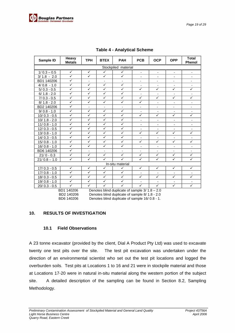
9.3 Analytical Rationale
The selection of soil samples chosen for laboratory analysis was based on field observation,
odour and PID response. The analytical regime for the soil samples selected for analysis is
shown in Table 4. A total of 26 selected samples (including 3 replicate samples for QA/QC)
were analysed for various combinations of the contaminants of concern (refer to Table 3).
Envirolab Services Pty Ltd, a laboratory accredited by the National Association of Testing
Authorities (NATA), was engaged to conduct the sample analysis.
Page 19 of 29
Preliminary Contamination Assessment of Stockpiled Material and General Land Quality Project 43756A Light Horse Business Centre April 2006 Quarry Road, Eastern Creek
Table 4 - Analytical Scheme
Sample ID Heavy Metals TPH BTEX PAH PCB OCP OPP Total
Phenol Stockpiled material
1/ 0.3 – 0.5 - - - - 3/ 1.8 - 2.0 - - - - BD1 140206 - - - - - - - 4/ 0.8 - 1.0 - - - - 5/ 0.3 - 0.5 6/ 1.8 - 2.0 - - - - 7/ 0.3 - 0.5 8/ 1.8 - 2.0 - - -
BD2 140206 - - - - - - - 9/ 0.8 - 1.0 - - - -
10/ 0.3 - 0.5 10/ 1.8 - 2.0 - - - - 11/ 0.8 - 1.0 - - - - 12/ 0.3 - 0.5 - - - - 13/ 0.8 - 1.0 14/ 0.3 - 0.5 - - - - 15/ 0.8 - 1.0 16/ 0.8 - 1.0 - - - - BD6 140206 - - - - - - - 21/ 0 - 0.3
21/ 0.8 – 1.0 In-situ material
17/ 0.3 - 0.5 17/ 0.8 - 1.0 - - - - 18/ 0.3 - 0.5 19/ 0.8 - 1.0 - - - - 20/ 0.3 - 0.5
BD1 140206 Denotes blind duplicate of sample 3/ 1.8 – 2.0 BD2 140206 Denotes blind duplicate of sample 8/ 1.8 - 2.0 BD6 140206 Denotes blind duplicate of sample 16/ 0.8 - 1.
10. RESULTS OF INVESTIGATION
10.1 Field Observations
A 23 tonne excavator (provided by the client, Dial A Product Pty Ltd) was used to excavate
twenty one test pits over the site. The test pit excavation was undertaken under the
direction of an environmental scientist who set out the test pit locations and logged the
overburden soils. Test pits at Locations 1 to 16 and 21 were in stockpile material and those
at Locations 17-20 were in natural in-situ material along the western portion of the subject
site. A detailed description of the sampling can be found in Section 8.2, Sampling
Methodology.

Page 20 of 29
Preliminary Contamination Assessment of Stockpiled Material and General Land Quality Project 43756A Light Horse Business Centre April 2006 Quarry Road, Eastern Creek
Overburden Stockpile (Locations 1 – 16, 21)
The field work at the above locations encountered stockpiled VENM sourced material from
the adjacent quarry. The stockpiled material comprised:
- Grey-black ripped sandstone and mudstone filling, cobble and boulder inclusions; and
- Brown gravely clay filling with sandstone cobble inclusions.
In-situ Natural Material (Locations 17 – 20) The field work at the above locations typically encountered the following conditions:
Top soil: The top soil contained a mixture of brown silt with rootlets to 200 mm depth.
Natural Material: The natural material is a mixture of light grey mottled red brown silty clay
and brown silty sandy clay, with some ironstone gravel.
Details of the conditions encountered at each test location are given in Appendix G,
together with notes defining classification methods and descriptive terms. A summary of
the materials encountered in the overburden stockpile and in-situ natural material is
presented in Table 5 below.
Table 5 - Summary of Material Encountered
Location Depth Material Description
1- 16 and 21
-
- Grey-black ripped sandstone and mudstone filling, cobble and boulder inclusions; and
- Brown gravely clay filling with sandstone cobble inclusions.
17-20
0 – 0.2 Top soil – brown silt with rootlets
0.2 – 0.6 Silty clay - yellow brown mottled silty clay, with trace fine gravel
0.6 - 2.2 Silty clay – red brown mottled silty clay, some ironstone gravel
>1.5 – 2.4
Siltstone – extremely weathered, light grey siltstone.
Shale – extremely weathered, grey shale and siltstone.

Page 21 of 29
Preliminary Contamination Assessment of Stockpiled Material and General Land Quality Project 43756A Light Horse Business Centre April 2006 Quarry Road, Eastern Creek
10.2 Total Photoionisable Compounds (TOPIC) Results
PID results are indicated on the bore logs and test pit logs for the in - situ material and
indicated on the record of samples for the stockpile material and are presented in Appendix
G. The photoionisation detector (PID) indicated that all PID readings were below 6 ppm,
indicating the absence of volatile compounds in the soil samples.
10.3 Laboratory Analysis
10.3.1 Results of Laboratory Analysis The results of laboratory analysis for the stockpiled material (Appendix H) are presented in
the following tables:
Table 6 – Results of Laboratory Analysis of Stockpile Material for Heavy Metals
Table 7 – Results of Laboratory Analysis of Stockpile Material for TPH and BTEX;
Table 8 – Results of Laboratory Analysis of Stockpile Material for OCP and OPP; and
Table 9 – Results of Laboratory Analysis of Stockpile Material for PCB, PAH and total
Phenolics.

Page 22 of 29
Preliminary Contamination Assessment of Stockpiled Material and General Land Quality Project 43756A Light Horse Business Centre April 2006 Quarry Road, Eastern Creek
Table 6 – Results of Laboratory Analysis of Stockpile Material for Heavy Metals
Sample ID As Cd Cr Cu Pb Hg Ni Zn (mg/ kg) (mg/ kg) (mg/ kg) (mg/ kg) (mg/ kg) (mg/ kg) (mg/ kg) (mg/ kg)
Overburden Stockpile 1/ 0.3 – 1.0 5.4 <1 12 43 16 <0.1 32 81 3/ 1.8 -2.0 8 <1 35 42 20 <0.1 38 74
BD1 140206 5.9 <1 31 38 17 <0.1 35 72 4/ 0.8 – 1.0 8.3 <1 24 42 17 <0.1 32 71 5/ 0.3 – 0.5 6.5 <1 12 48 17 <0.1 21 75 6/ 1.8 – 2.0 6.5 <1 21 48 21 <0.1 30 68 7/ 0.3 – 0.5 7.8 <1 18 47 18 <0.1 26 68 8/ 1.8 – 2.0 4.9 <1 28 37 16 <0.1 43 66 BD2 140206 6.7 <1 27 34 14 <0.1 43 66 9/ 0.8 – 1.0 6.1 <1 31 45 17 <0.1 36 78 10/ 0.3 – 0.5 5.9 <1 11 48 17 <0.1 24 77 10/ 1.8 – 2.0 7.9 <1 19 24 18 <0.1 13 50 11/ 0.8 – 1.0 <4 <1 11 50 19 <0.1 25 90 12/ 0.3 – 0.5 4.2 <1 13 38 19 <0.1 25 73 13/ 0.8 – 1.0 6.4 <1 33 42 17 <0.1 37 68 14/ 0.3 – 0.5 7.7 <1 28 33 15 <0.1 31 69 15/ 0.8 – 1.0 <4 <1 150 38 10 <0.1 100 65 16/ 0.8 – 1.0 7.8 <1 24 40 15 <0.1 30 63 BD6 140206 7.7 <1 28 43 17 <0.1 34 68 21/ 0 - 0.3 5.9 <1 22 42 18 <0.1 32 62
21/ 0.8 – 1.0 5.5 <1 17 44 17 <0.1 24 79 In-situ Natural Material
17/ 0.3 - 1.0 7.3 <1 21 26 26 <0.10 13 46 17/ 0.8 -1.0 9.1 <1 18 44 33 <0.10 12 56 18/ 0.3 – 0.5 6.9 <1 21 28 19 <0.10 10 31 19/ 0.8 – 1.0 13 <1 9.1 37 11 <0.10 6 33 20/ 0.3 – 0.5 15 <1 17 39 24 <0.10 22 88 Guideline 1 1 – 50 1 5 – 1000 2 – 100 2 – 200 0.03 5 – 500 10 - 300 Guideline 2 20 3 400 100 300 1 60 200
Notes: Guideline 1 and 2 - Refer to Table 3 of the report BD1 140206 Denotes blind duplicate of sample 3/ 1.8 – 2.0 BD2 140206 Denotes blind duplicate of sample 8/ 1.8 - 2.0 BD6 140206 Denotes blind duplicate of sample 16/ 0.8 - 1.0 Bold Exceeds Guideline 2.

Page 23 of 29
Preliminary Contamination Assessment of Stockpiled Material and General Land Quality Project 43756A Light Horse Business Centre April 2006 Quarry Road, Eastern Creek
Table 7 – Results of Laboratory Analysis of Stockpile Material for TPH & BTEX
Sample ID
Total Petroleum Hydrocarbons (TPH) Monocyclic Aromatic Hydrocarbons (BTEX)
C6 - C9 (mg/ kg)
C10 - C14 (mg/ kg)
C15 - C28 (mg/ kg)
C29 - C36 (mg/ kg)
Benzene (mg/ kg)
Toluene (mg/ kg)
Ethyl benzene
(mg/ kg)
Xylene (mg/ kg)
Overburden Stockpile 1/ 0.3 – 1.0 <25 <50 <100 <100 <1.0 <1.0 <1.0 <1.0 3/ 1.8 -2.0 <25 <50 <100 <100 <1.0 <1.0 <1.0 <1.0 4/ 0.8 – 1.0 <25 <50 <100 <100 <1.0 <1.0 <1.0 <1.0 5/ 0.3 – 0.5 <25 <50 <100 <100 <1.0 <1.0 <1.0 <1.0 6/ 1.8 – 2.0 <25 <50 <100 <100 <1.0 <1.0 <1.0 <1.0 7/ 0.3 – 0.5 <25 <50 <100 <100 <1.0 <1.0 <1.0 <1.0 8/ 1.8 – 2.0 <25 <50 <100 <100 <1.0 <1.0 <1.0 <1.0 9/ 0.8 – 1.0 <25 <50 <100 <100 <1.0 <1.0 <1.0 <1.0 10/ 0.3 – 0.5 <25 <50 <100 <100 <1.0 <1.0 <1.0 <1.0 10/ 1.8 – 2.0 <25 <50 <100 <100 <1.0 <1.0 <1.0 <1.0 11/ 0.8 – 1.0 <25 <50 <100 <100 <1.0 <1.0 <1.0 <1.0 12/ 0.3 – 0.5 <25 <50 <100 <100 <1.0 <1.0 <1.0 <1.0 13/ 0.8 – 1.0 <25 <50 <100 <100 <1.0 <1.0 <1.0 <1.0 14/ 0.3 – 0.5 <25 <50 <100 <100 <1.0 <1.0 <1.0 <1.0 15/ 0.8 – 1.0 <25 <50 <100 <100 <1.0 <1.0 <1.0 <1.0 16/ 0.8 – 1.0 <25 <50 <100 <100 <1.0 <1.0 <1.0 <1.0 21/ 0 - 0.3 <25 <50 <100 <100 <1.0 <1.0 <1.0 <1.0
21/ 0.8 – 1.0 <25 <50 <100 <100 <1.0 <1.0 <1.0 <1.0 In-situ Natural Material
17/ 0.3 - 1.0 <25 <50 <100 <100 <1.0 <1.0 <1.0 <1.0 17/ 0.8 -1.0 <25 <50 <100 <100 <1.0 <1.0 <1.0 <1.0 18/ 0.3 – 0.5 <25 <50 <100 <100 <1.0 <1.0 <1.0 <1.0 19/ 0.8 – 1.0 <25 <50 <100 <100 <1.0 <1.0 <1.0 <1.0 20/ 0.3 – 0.5 <25 <50 <100 <100 <1.0 <1.0 <1.0 <1.0 Guideline 1 NA NA 0.05– 1.0 NA NA NA Guideline 2 65 1000 1 1.4 3.1 1.4
Notes: Guideline 1 and 2 - Refer to Table 3 of the report Bold Exceeds Guideline 2.
NA Not Applicable

Page 24 of 29
Preliminary Contamination Assessment of Stockpiled Material and General Land Quality Project 43756A Light Horse Business Centre April 2006 Quarry Road, Eastern Creek
Table 8 – Results of Laboratory Analysis of Stockpile Material for OCP and OPP
Sample ID
Organochlorine Pesticides (OCP)OPP
(mg/ kg) Aldrin (mg/ kg)
Dieldrin (mg/ kg)
Chlordane (mg/ kg)
DDD+DDE+DDT
(mg/ kg) Heptachlor
(mg/ kg)
Overburden Stockpile 5/ 0.3 – 0.5 <0.1 <0.1 <0.1 <0.1 <0.1 <0.17/ 0.3 – 0.5 <0.1 <0.1 <0.1 <0.1 <0.1 <0.18/ 1.8 – 2.0 <0.1 <0.1 <0.1 <0.1 <0.1 <0.1
10/ 0.3 – 0.5 <0.1 <0.1 <0.1 <0.1 <0.1 <0.113/ 0.8 – 1.0 <0.1 <0.1 <0.1 <0.1 <0.1 <0.115/ 0.8 – 1.0 <0.1 <0.1 <0.1 <0.1 <0.1 <0.121/ 0 - 0.3 <0.1 <0.1 <0.1 <0.1 <0.1 <0.1
21/ 0.8 – 1.0 <0.1 <0.1 <0.1 <0.1 <0.1 <0.1In-situ Natural Material
17/ 0.3 - 1.0 <0.1 <0.1 <0.1 <0.1 <0.1 <0.1 18/ 0.3 – 0.5 <0.1 <0.1 <0.1 <0.1 <0.1 <0.1 20/ 0.3 – 0.5 <0.1 <0.1 <0.1 <0.1 <0.1 <0.1 Guideline 1 NA NA NA NA NA Guideline 2 10 50 200 10 NA
Notes: Guideline 1 and 2 - Refer to Table 3 of the report Bold Exceeds Guideline 2. NA Not Applicable
Table 9 – Results of Laboratory Analysis of
Stockpile Material for PCB, PAH and total Phenolics
Sample ID
Total PCB
Benzo(a)pyrene PAH Total
Phenolics
(mg/ kg) (mg/ kg) (mg/ kg)
(mg/ kg)
Overburden Stockpile 5/ 0.3 – 0.5 <0.1 <0.050 <0.1 <5.0 7/ 0.3 – 0.5 <0.1 <0.050 <0.1 <5.0 8/ 1.8 – 2.0 <0.1 <0.050 <0.1 <5.0 10/ 0.3 – 0.5 <0.1 <0.050 <0.1 <5.0 13/ 0.8 – 1.0 <0.1 <0.050 <0.1 <5.0 15/ 0.8 – 1.0 <0.1 <0.050 <0.1 <5.0 21/ 0 - 0.3 <0.1 <0.050 <0.1 <5.0
21/ 0.8 – 1.0 <0.1 <0.050 <0.1 <5.0 In-situ Natural Material
17/ 0.3 - 1.0 <0.1 <0.050 <0.10 <5.0 18/ 0.3 – 0.5 <0.1 <0.050 <0.10 <5.020/ 0.3 – 0.5 <0.1 <0.050 <0.10 <5.0Guideline 1 NA NA 0.95-5.0 NA Guideline 2 10 1 20 70
Notes: Guideline 2 - Refer to Table 3 of the report Bold Exceeds Guideline 2. NA Not Applicable

Page 25 of 29
Preliminary Contamination Assessment of Stockpiled Material and General Land Quality Project 43756A Light Horse Business Centre April 2006 Quarry Road, Eastern Creek
10.4 QA/QC Procedures and Results Quality assurance/quality control procedures comprised an integral part of this Preliminary
Assessment, and included both field and laboratory QA/QC procedures (see Appendix I).
11. DISCUSSION
11.1 Review of Available Site History Information
The 1947 aerial photograph shows that the subject site and surrounding area was largely
open grassland, with the exception of the area to the north east which was divided into
paddocks that had been tilled. The results of the title deeds search illustrate that the site
was used for agricultural purposes, probably grazing, up until 1955.
Lot 2 DP 262213 was purchased by Burfield Pty Limited (later known as Ray Fitzpatrick Pty
Limited) in 1955. The subject site, Site A, is a portion of Lot 2 DP 262213, located in the
central, western portion of the Lot. A quarry commenced operation on the eastern half of
Lot 2 DP 262213 and the adjacent property to the east, Lot 1 DP 400697, in the 1950’s.
By 1970 an extensive quarry pit had been excavated to the east of the site and office
buildings, plants and stockpiled material were located to the south of the quarry. A
significant volume of overburden, presumably from the quarry, had been placed on the
northern portion of Site A. In the 1986 aerial photograph the quarry had been extended
both laterally and vertically. In addition, the stockpiled material on Site A had extended to
the southern portion of Site A.
The site appeared relatively unchanged in the 2002 aerial photograph with the exception of
the removal of small sheds which are believed to have stored explosives for quarrying
activities. It is understood that the quarry has been operational since the 1950’s and it is
considered that overburden was placed on the stockpile since the commencement of
quarrying activities.

Page 26 of 29
Preliminary Contamination Assessment of Stockpiled Material and General Land Quality Project 43756A Light Horse Business Centre April 2006 Quarry Road, Eastern Creek
The potential contaminants associated with the site are:
• Fertilisers and pesticides associated with agricultural activities; and
• Heavy metals, TPH, BTEX, PAHs, solvents and asbestos, associated with the dumping
of material on the overburden stockpile.
A number of environmental assessments have been undertaken on the surrounding quarry
area by other consultants, assessing the potential of quarry activities to impact the
surrounding area. A sampling and analytical regime was undertaken by others which
comprised the collection of soil and surface water samples from drainage lines, reservoirs
and soil samples from locations surrounding the quarry site. The results indicated that
sediment samples along drainage lines and reservoirs contained heavy metal
concentrations above the adopted guideline threshold. It is noted that Quarry operators
Hanson Operations, have undertaken a pollution reduction programme with the DEC that
monitored the waters discharging from the site and no ‘Notices’ have been issued regarding
this matter.
Following the above mention investigation, additional fieldwork was undertaken at discrete
locations on the quarry site, including the asphalt plant, Pioneer Road Services section, the
overburden stockpile (Site A) and the quarry pit. The results indicated that significant
contamination occurred at discrete locations, including the workshop area, the tank farm
and the kerosene wash down area. These contaminated areas are not located within Site
A, the area being assessed in this current investigation.
No signs of waste material were noted on the overburden stockpiled material during ADI’s
1998 investigation. The samples were compared with ‘background’ samples collected from
Area 3, located to the south of Site A, which has remained unaffected by quarrying
activities. With the exception of nickel concentrations, the overburden samples were found
to be consistent with contaminant concentrations found in the ‘background’ samples from
Area 3. However, it is noted that the elevated nickel concentrations in the overburden
stockpile samples were found to be consistent with the nickel concentration of two natural
breccia samples collected from the adjacent quarry.
Page 27 of 29
Preliminary Contamination Assessment of Stockpiled Material and General Land Quality Project 43756A Light Horse Business Centre April 2006 Quarry Road, Eastern Creek
11.2 Overburden Stockpile Assessment
The analytical results indicate that the heavy metal and PAH concentrations of the
overburden stockpile material, that was sourced as VENM from the quarry area are within
Australian background ranges.
It is noted that one sample (15/0.8-1.0) recorded a concentration of nickel (100 mg/kg)
above the NSW DEC provisional phototoxicity-based investigation levels (60 mg/kg).
However, it is noted that the nickel concentration is within the DEC Health based
investigation levels for residential use (600 mg/kg).
The elevated nickel concentration is consistent with the nickel concentration of material
collected from the adjacent quarry in the Stage 2 investigation by ADI (1998). On this basis,
the nickel concentration 100 mg/kg in sample 15/0.8-1.0 is considered to be representative
of background concentrations of natural material sourced from the adjacent quarry. Nickel
is a common element in basic igneous rocks with local dolerites understood to have levels
>360 mg/kg, with chromium >550 mg/kg, and copper >100 mg/kg.
The selected samples analysed for TPH, BTEX, PCB, PAH, OCP, OPP and phenol were
found to be below laboratory quantification limits, indicating that the VENM-sourced
material, located within the top 2.8 m of the stockpile, has not been contaminated during
handling or whilst stored on the stockpile.
No signs of anthropogenic inclusions were noted at the time of field work and on this basis,
asbestos was not analysed.
11.3 Preliminary Assessment of In-situ material
The concentration of selected samples analysed for heavy metals were found to be within
the Site Assessment Criteria for residential sites with accessible soil. On this basis, the
subsurface soils analysed are not considered to be contaminated.

Page 28 of 29
Preliminary Contamination Assessment of Stockpiled Material and General Land Quality Project 43756A Light Horse Business Centre April 2006 Quarry Road, Eastern Creek
The soil samples submitted for laboratory analysis reported TPH, PAH, BTEX, OCP, OPP,
PCB and Phenols concentrations below the practical quantification limit. Hence the
concentrations for all of these compounds were within the Site Assessment Criteria for
residential sites with accessible soils.
12. CONCLUSIONS
The analytical results were found to be below the adopted threshold criteria for both the
stockpile and the in-situ material. On this basis, the stockpiled material, which was sourced
as VENM from the quarry is considered suitable for off-site re-use as VENM fill. However, it
is noted that the assessment of the stockpile was limited to the top 2.8 m of the stockpile. If
material different to that described in the test pit logs, or if material showing signs of
contamination (identified by odours, stains, or anthropogenic inclusions) is encountered
additional testing shall be required. Irrespective it is recommended that additional samples
are collected and analysed on a regular basis (and prior to removal) as the stockpile is
progressively excavated for any off site use.
The preliminary analysis of in-situ material indicates that the site is suitable for commercial/
industrial use. However, following the removal of the stockpiled material it is recommended
that additional field work and laboratory analysis and reporting are undertaken to a level
commensurate with the site area intended for redevelopment and according to relevant
published guidelines.
13. LIMITATIONS OF THIS REPORT
The scope of the site assessment activities and consulting services undertaken by DP were
limited to those detailed in the proposal dated 20 January 2006 and by the accompanying
conditions of engagement.

Page 29 of 29
Preliminary Contamination Assessment of Stockpiled Material and General Land Quality Project 43756A Light Horse Business Centre April 2006 Quarry Road, Eastern Creek
DP’s assessment is necessarily based upon the result of a limited site investigation and the
restricted programme of surface and subsurface sampling, screening and chemical testing
which was set out in the proposal. DP cannot provide unqualified warranties with regards to
contamination nor does DP assume any liability for site conditions not observed or
accessible during the time of the investigations.
Despite all reasonable care and diligence, the ground conditions encountered and
concentrations of contaminants measured may not be representative of conditions between
the locations sampled and investigated. In addition, site characteristics may change over
time due to activities such as spillages of contaminating substances. These changes may
occur subsequent to DP’s investigations and assessment.
This report, its associated documentation and the information herein have been prepared
solely for the use of Dial A Product Pty Ltd. Any reliance assumed by third parties on this
report shall be at such parties’ own risk.
DOUGLAS PARTNERS PTY LTD Reviewed by Catherine Karpiel Lindsay Rockett Environmental Scientist Senior Associate J M Nash Principal

APPENDIX A Notes Relating to This Report
Site Drawing and Photographs


APPENDIX I Quality Assurance/Quality Control Procedures and Results

QA/ QC PROCEDURES AND RESULTS
The field QC procedures for sampling as prescribed in Douglas Partners Field
Procedures Manual were followed at all times during the validation assessment. Field
sampling comprised replicate sampling, at a rate of approximately one replicate sample
for every ten original samples.
Relative Percentage Difference The field QC comprised the collection of at least 10% replicate samples during the
course of sampling. In total, sixty eight soil samples were obtained from the subject
site, four of which were replicate samples. A total of five soil samples were selected for
laboratory analysis and no duplicate soil samples were collected. However, twenty one
stockpile samples were selected for laboratory analysis, of which three were replicate
samples. The replicate samples were analysed for heavy metals and the comparative
results of analysis are included in Table 1I. Relative Percentage Differences (RPD) were
calculated as an assessment of the result consistency.
A measure of the consistency of results is derived by the calculation of relative
percentage differences (RPD’s) for replicate samples. Generally, an RPD of ± 30% is
considered acceptable by the EPA, however, certain exceptions apply. The RPD’s,
which were calculated using the heavy metal concentrations, are tabulated below.
Table 1I – Comparative Results of Replicate Sample Analysis for Heavy Metals Sample ID Arsenic Cadmium Chromium^ Copper Lead Mercury Nickel Zinc
3/ 1.8 -2.0 8 <1 35 42 20 <0.1 38 74 BD1 140206 5.9 <1 31 38 17 <0.1 35 72
RPD % 30.2 - 12.1 10.0 16.2 - 8.2 2.7 8/ 1.8 – 2.0 4.9 <1 28 37 16 <0.1 43 66
BD2 140206 6.7 <1 27 34 14 <0.1 43 66 RPD % 31.0 3.6 8.5 13.3 0.0 0.0
16/ 0.8 – 1.0 7.8 <1 24 40 15 <0.1 30 63 BD6 140206 7.7 <1 28 43 17 <0.1 34 68
RPD % 1.3 15.4 7.2 12.5 12.5 7.6
All the RPD results for heavy metals fall within the typical acceptable range (± 30%), with
the exception arsenic from samples 3/ 1.8 - 2.0 and 8/ 1.8 – 2.0. The calculated RPD
exceeding the acceptability range is not, however, considered to be of significant
concern due to the generally low levels of arsenic detected (relative to the adopted
guideline levels), the low actual differences in concentration and the generally
heterogenous nature of the material. It is therefore considered that the results indicate
an acceptable consistency between the samples and their replicates and indicates that
suitable field sampling methodology was adopted and laboratory precision was
achieved.
Laboratory QA/ QC Procedures
The analytical laboratory is accredited by the National Association of Testing Authorities
(NATA) and is required to conduct in - house QA/ QC procedures. These are normally
incorporated into every analytical run and include the following: -
Reagent Blank A reagent blank sample is prepared and analysed at the beginning of every analytical
run, following calibration of the analytical apparatus. The laboratory results for reagent
blanks for soil analysis indicated that concentrations of all analytes were below
respective laboratory practical quantitation (detection) limits. These results are included
in the laboratory report in Appendix H.
Spike Recovery Spike recovery tests were conducted by adding a known amount of a particular analyte
or analytes prior to analysis, and then treating the spiked sample in exactly the same
manner as all other samples. The recovery results indicate the proportion of the known
concentration of the target analytes which were detected during analysis. Spike
recovery results are included in the laboratory report in Appendix H. The spike recovery
results all fell within the acceptable range thus the results are considered to be
acceptable.