appendix d water management assessment summary centre... · appendix d water management assessment...
TRANSCRIPT
Shire of RoebourneTown Planning Scheme No. 8Amendment No. 29
APPENDIX D
WATER MANAGEMENT
ASSESSMENT SUMMARY
J5149b 19 September 2012 1
Jim Davies & Associates Pty Ltd
ABN 24 067 295 569Suite 1, 27 York Street, SubiacoPO Box 117, Subiaco WA 6008
Ph: (08) 9388 2436Fx: (08) 9381 9279
To : TME Date : 19 Sept 12 Attention : Kris Kennedy Our Ref : J5149b
Email : [email protected] Pages : 6
LAZY LANDS, KARRATHA
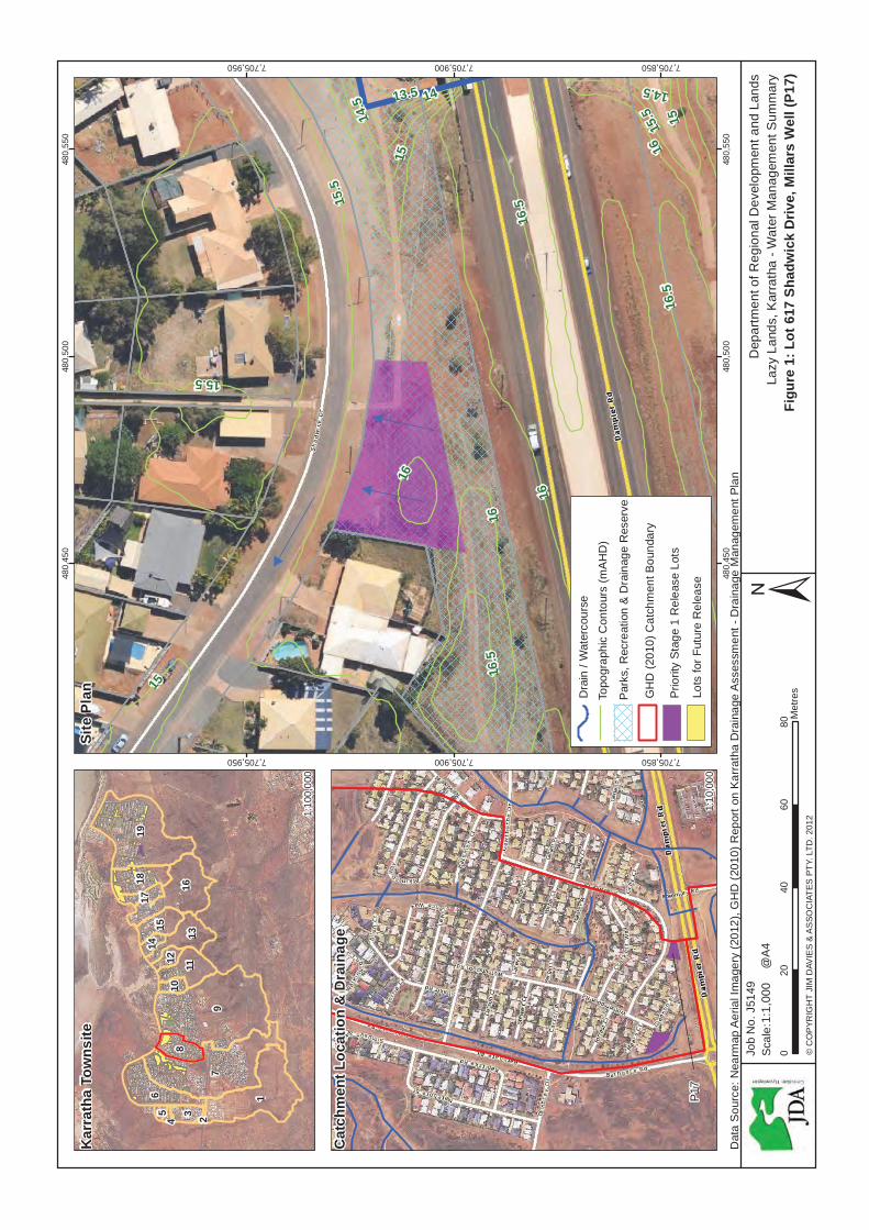
WATER MANAGEMENT SUMMARY – LOT 617 SHADWICK DRIVE, MILLARS WELL (P17)
Kris,
Please find below summary report prepared by JDA Consultant Hydrologists providing hydrological advice to support Scheme Amendment Rezoning of Lot 617 Shadwick Drive, Millars Well (P17), from ‘Parks, Recreation & Drainage’ to ‘Urban’. The report is presented in the following sections:
1. Introduction
2. Lot Details
3. Major Flooding & Storm Surge
4. Catchment Drainage
5. Lot Drainage
6. Conclusions
1. Introduction
The Department of Regional Development and Lands (RDL) through its Pilbara Cities Office (PCO) is carrying out a residential infill program in Karratha known as ‘Lazy Lands’. The Lazy Lands Program seeks to identify vacant Crown Land within existing urban areas that can be quickly brought into the residential land release pipeline to help alleviate the current supply shortage of development-ready land in Karratha.
A total of 61 parcels of land have previously been identified with 7 being targeted for release as a priority under Stage 1. Lot 617 Shadwick Drive, Millars Well, is one of 7 of the Stage 1 priority sites. Lot 617 is denoted as site P17 in Appendix 2-3 of RDL’s tender document for the Lazy Lands Project.
Detailed 2D flood modelling at a 2m x 2m grid is currently being carried out by JDA as part of this study to determine the 100 yr ARI flood levels and extent across Karratha for the current climate scenario (2010). The results will be used to assess any impact of flooding on the sites from any adjacent drain and inform future finished Lot level design. The 2D flood modelling results will be reported in a Local Water Management Strategy (LWMS).
2. Lot Details
Referring to Figure 1, the Lot is 0.09 ha and located 4 km west of the Karratha City centre, within the suburb of Millars Well. Lot access is off Shadwick Drive with an
JDA Consultant Hydrologists
J5149b 19 September 2012 2
JDA
existing residential building located adjacent to the Lot to the west and a footpath to the east.
Existing natural surface contours are shown on Figure 1 indicating the Lot is relatively flat with an elevation of 16.0 mAHD along the south-western boundary with a slight gradient toward the street front at the northern boundary with an elevation of 15.5 mAHD. Lot 617 is part of a Parks, Recreation and Drainage reserve as shown on Figure 1.
3. Major Flood & Storm Surge
The draft Karratha Coastal Vulnerability Study (KCVS) prepared by JDA et. al. (2011) on behalf of LandCorp provides rainfall runoff, storm surge and associated flood level 2-Dimensional (2D) modelling and mapping across the Karratha region. The KCVS was produced to assist and inform future development of the Karratha region at a district scale level of detail. Modelling was undertaken for various climate scenarios including present day (2010) and 50 year (2060) and 100 year (2110). Note that flood levels (in mAHD) produced are based on regional scale modelling and are subject to refinement to the local scale.
Email advice from the Department of Water (DoW) on 10 September 2012 to the Shire of Roebourne is attached. This confirms that the natural surface of the Lot is greater than the 100 year Average Recurrence Interval (ARI) and 500 Year ARI water levels, from storm surge and catchment flooding, for the 2010, 2060 and 2110 climate scenarios from the draft KCVS. DoW notes that this advice is related to storm surge and major flooding only and does not take into account local stormwater drainage.
4. Catchment Drainage
Figure 1 shows that Lot 617 is at the upper reaches of Catchment 8, which is one the smaller catchments in the Karratha area (GHD, 2010), with the boundary to the south along Dampier Road. Lot 617 is not located immediately adjacent to any open drainage channel. The closest open drainage channel starts approximately 140m to the west which is one of the main drainage arteries in Catchment 8 (GHD, 2010).
5. Lot Drainage
Stormwater runoff from the Lot is directed toward Shadwick Drive which then flows northwest with the fall in road elevation. There is very little contributing upstream catchment expected to influence the Lot and all local stormwater runoff is anticipated to be contained within the depth of the road kerb.
During development, it is envisaged that stormwater runoff will continue to discharge directly into the Shadwick Drive local road drainage system at the front of the Lot. Detail design of management of stormwater will be presented in a Stormwater Management Plan, required by the Shire of Roebourne, to be submitted with the Development Application. Criteria to be addressed include;
2D flood modelling 100 yr ARI water level in adjacent drain
Finished Lot level design
Local stormwater management
Runoff direction
Erosion control
JDA Consultant Hydrologists
J5149b 19 September 2012 3
JDA
6. Conclusions
For Major Flood & Storm Surge, DoW has advised that the natural surface of Lot 617 is above the 100 year ARI and 500 year ARI events.
For Catchment Drainage, Lot 617 is located within Catchment 8 (GHD, 2010) which is one the smaller catchments in the Karratha area. There are no adjacent open drainage channels.
For Lot Drainage, stormwater runoff is directed toward Shadwick Drive at the northern boundary of the Lot which then flows northwest within the width of the road extent. Stormwater runoff is anticipated to be contained with the depth of the road kerb.
A Stormwater Management Plan will be required by the Shire of Roebourne to support a future Development Application for Lot 617.
This Water Management Summary supports the proposed Scheme Amendment and Rezoning from ‘Parks, Recreation & Drainage’ to ‘Urban’.
References
GHD (2010), Report on Karratha Drainage Assessment - Drainage Management Plan; for Shire of Roebourne JDA Consultant Hydrologists, GEMS, Damara WA, Coastal Zone Management & DHI Water & Environment (2011) Karratha Coastal Vulnerability Study (Draft); for LandCorp
If you have any queries, please do not hesitate to contact Matthew Yan or Damien Slack.
Yours sincerely,
JDA CONSULTANT HYDROLOGISTS DISCLAIMER
This document is published in accordance with and subject to an agreement between JDA Consultant Hydrologists (“JDA”) and the client for whom it has been prepared (“Client”), and is restricted to those issues that have been raised by the Client in its engagement of JDA. It has been prepared using the skill and care ordinarily exercised by Consultant Hydrologists in the preparation of such documents.
Any person or organisation that relies on or uses the document for purposes or reasons other than those agreed by JDA and the Client without first obtaining a prior written consent of JDA, does so entirely at their own risk and JDA denies all liability in tort, contract or otherwise for any loss, damage or injury of any kind whatsoever (whether in negligence or otherwise) that may be suffered as a consequence of relying on this document for any purpose other than that agreed with the Client.
16
15.5
16.5
15
14
14.5 13.5
16
14.5
15.5
15.5
1616
.5
16.5
16
16
15
15
480,
450
480,
450
480,
500
480,
500
480,
550
480,
550
7,705,850
7,705,850
7,705,900
7,705,900
7,705,950
7,705,950
Dep
artm
ent o
f Reg
iona
l Dev
elop
men
t and
Lan
dsLa
zy L
ands
, Kar
rath
a - W
ater
Man
agem
ent S
umm
ary
Figu
re 1
: Lot
617
Sha
dwic
k D
rive,
Mill
ars
Wel
l (P1
7)±
Job
No.
J51
49
© C
OP
YRIG
HT
JIM
DAV
IES
& A
SSO
CIA
TES
PTY
. LTD
. 201
2
Dat
a S
ourc
e: N
earm
ap A
eria
l Im
ager
y (2
012)
, GH
D (2
010)
Rep
ort o
n K
arra
tha
Dra
inag
e A
sses
smen
t - D
rain
age
Man
agem
ent P
lan
020
4060
80M
etre
s
Sca
le:1
:1,0
00@
A4
97
1
196
168
18
1311
15
3
17
1210
145
4 2
Kar
rath
a To
wns
ite
Cat
chm
ent L
ocat
ion
& D
rain
age
1:10
0,00
0
1:10
,000
GH
D (2
010)
Cat
chm
ent B
ound
ary
Prio
rity
Sta
ge 1
Rel
ease
Lot
s
Topo
grap
hic
Con
tour
s (m
AH
D)
Par
ks, R
ecre
atio
n &
Dra
inag
e R
eser
ve
Site
Pla
n Lots
for F
utur
e R
elea
seP
17
Dra
in /
Wat
erco
urse

From: SMYTHE Toni [mailto:[email protected]]Sent: Monday, 10 September 2012 9:25 AM To: Monica Sullivan Subject: RE: Flood advice for Lazy Lands sites
Hi Monica,
Please find the below advice for Lot 617 Shadwick Drive in Millars Well.
The Department of Water, in carrying out its role in floodplain management, provides advice andrecommends guidelines for development on floodplains with the object of minimising flood risk anddamage.
The preliminary results of the Karratha Coastal Vulnerability Study show that in this area theinundation levels for large storm surge events are expected to be:
100 year ARI 500 year ARIAt 2010 14.3m AHD 14.6m AHDAt 2060 14.3m AHD 14.8m AHDAt 2110 14.3m AHD 14.9m AHD
The estimates include flooding generated from storm surge and catchment flooding, and theestimates for 2060 and 2110 include an allowance of 0.3 metres and 0.9 metres respectively forpossible future sea level rise.
The available contour information for the area shows the general natural surface level of the lot tobe between ~15.5 m AHD and 16.5 m AHD (see attached plan).
Please note that this advice is related to storm surge and major flooding only and does not take intoaccount local stormwater drainage.
For further information please contact Simon Rodgers on (08)6364 6923 or via email [email protected].
Kind regards,
Toni SmytheEngineer, Floodplain ManagementDepartment of WaterTelephone: (08) 6364 7413E mail: [email protected]

1516
15.5
16.5
1717
.5
18
14
14.5
13.5
14.5
15.5
16.5
16.5
15
15.5
15.5
16
15.5
15.5
16
16
16.5
14
DA
MPI
ER R
D
SHADWICK DR
REE
D C
T
CROC
KETT
WAY
ROSEMARY RD
GLEES
ON PL
GR
AY C
T
4199
6921
3808
4690
2070
617
2071
2648
2075
2076
2073
2069
7
2072
3820
2077
2068
2066
2078
2079
2056
3817
2080
3
2064
2055
2054
2060
2053
2081
3809
4
2063
52
2087
6
2052
2135
2062
3821
2088
LEG
END
Lot 6
17 S
hadw
ick
Dr
Mill
ars
Wel
l
´
LOC
ALI
TY M
AP
# SK
AR
RA
THA
This
map
is a
pro
duct
of t
he D
epar
tmen
t of W
ater
,A
sses
smen
t & A
lloca
tion
and
was
prin
ted
on 7
/09/
2012
.
This
map
was
pro
duce
d w
ith th
e in
tent
that
it b
e us
edfo
r di
spla
y pu
rpos
es a
t the
sca
le o
f 1:1
,500
whe
npr
intin
g at
A4.
Whi
le th
e D
epar
tmen
t of W
ater
has
mad
e al
lre
ason
able
effo
rts to
ens
ure
the
accu
racy
of t
his
data
,th
e de
part
men
t acc
epts
no
resp
onsi
bilit
y fo
r any
inac
cura
cies
and
per
sons
rel
ying
on
this
dat
a do
so
at th
eir o
wn
risk.
SOU
RC
ES
Spa
tial C
adas
tral
Dat
abas
e - L
andg
ate
- 06/
02/1
2R
oad
Cen
trelin
es, D
LI -
Land
gate
- 13
/01/
2010
Wes
tern
Aus
tral
ian
Tow
ns -
Land
gate
- 1
2/07
/200
1
The
Dep
artm
ent o
f Wat
er a
ckno
wle
dges
the
follo
win
g da
tase
ts a
nd th
eir c
usto
dian
s in
the
prod
uctio
n of
this
map
:
Dat
um a
nd P
roje
ctio
n In
form
atio
nVe
rtica
l Dat
um: A
ustra
lian
Hei
ght D
atum
(AH
D71
)H
oriz
onta
l Dat
um: G
DA
94 M
GA
z50
Proj
ectio
n: U
nive
rsal
Tra
vers
e M
erca
tor (
UTM
)Sp
hero
id: G
eode
tic R
efer
ence
Sys
tem
(GR
S80
)
Proj
ect I
nfor
mat
ion
Clie
nt:
Map
Aut
hor:
Toni
Sm
ythe
Task
ID: B
1305
Com
pila
tion
date
: 7/0
9/20
12Ed
ition
: Ver
sion
1
Path
: J:\g
ispr
ojec
ts\P
roje
ct\B
_Ser
ies\
B130
5\00
01_F
PM_E
nqui
res\
mxd
\Kar
rath
a\FP
M K
arra
tha
Lot 6
17 S
hadw
ick
Dr e
nq.m
xd
Surfa
ce C
onto
urs
(m A
HD
)
Cad
astre
Lot 6
17 S
hadw
ick
Dr
010
2030
405
Met
res
J5149f 19 September 2012 1
Jim Davies & Associates Pty Ltd
ABN 24 067 295 569Suite 1, 27 York Street, SubiacoPO Box 117, Subiaco WA 6008
Ph: (08) 9388 2436Fx: (08) 9381 9279
To : TME Date : 19 Sept 12 Attention : Kris Kennedy Our Ref : J5149f
Email : [email protected] Pages : 6
LAZY LANDS, KARRATHA
WATER MANAGEMENT SUMMARY – LOT 655 WARRIER STREET, BULGARRA (P55)
Kris,
Please find below summary report prepared by JDA Consultant Hydrologists providing hydrological advice to support Scheme Amendment Rezoning of Lot 655 Warrier Street, Bulgarra (P55), from ‘Parks, Recreation & Drainage’ to ‘Urban’. The report is presented in the following sections:
1. Introduction
2. Lot Details
3. Major Flooding & Storm Surge
4. Catchment Drainage
5. Lot Drainage
6. Conclusions
1. Introduction
The Department of Regional Development and Lands (RDL) through its Pilbara Cities Office (PCO) is carrying out a residential infill program in Karratha known as ‘Lazy Lands’. The Lazy Lands Program seeks to identify vacant Crown Land within existing urban areas that can be quickly brought into the residential land release pipeline to help alleviate the current supply shortage of development-ready land in Karratha.
A total of 61 parcels of land have previously been identified with 7 being targeted for release as a priority under Stage 1. Lot 655 Warrier Street, Bulgarra, is one of 7 of the Stage 1 priority sites. Lot 655 is denoted as site P55 in Appendix 2-3 of RDL’s tender document for the Lazy Lands Project.
Detailed 2D flood modelling at a 2m x 2m grid is currently being carried out by JDA as part of this study to determine the 100 yr ARI flood levels and extent across Karratha for the current climate scenario (2010). The results will be used to assess any impact of flooding on the Lot from the adjacent drain and inform future finished Lot level design. The 2D flood modelling results will be reported in a Local Water Management Strategy (LWMS).
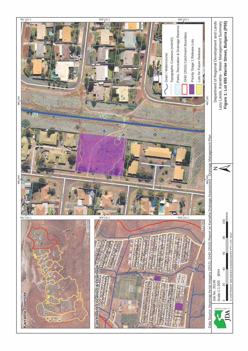
2. Lot Details
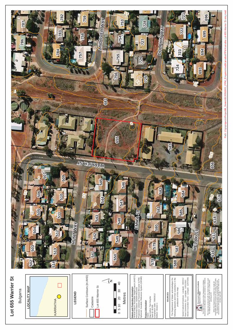
Referring to Figure 1, the Lot is 0.3 ha and located 2.2 km east of the Karratha City centre, within the
JDA Consultant Hydrologists
J5149f 19 September 2012 2
JDA
suburb of Bulgarra. The Lot is fronted by Warrier Street to the west and an open drain to the east. There are existing residential buildings located adjacent to the Lot to the north and south.
Existing natural surface contours are shown on Figure 1 indicating the Lot is relatively flat with a south to north sloping gradient with elevations ranging from 9.0 mAHD to 8.5 mAHD respectively. Lot 655 is part of a Parks, Recreation and Drainage reserve as shown on Figure 1.
3. Major Flood & Storm Surge
The draft Karratha Coastal Vulnerability Study (KCVS) prepared by JDA et. al. (2011) on behalf of LandCorp provides rainfall runoff, storm surge and associated flood level 2-Dimensional (2D) modelling and mapping across the Karratha region. The KCVS was produced to assist and inform future development of the Karratha region at a district scale level of detail. Modelling was undertaken for various climate scenarios including present day (2010) and 50 year (2060) and 100 year (2110). Note that flood levels (in mAHD) produced are based on regional scale modelling and are subject to refinement to the local scale.
Email advice from the Department of Water (DoW) on 10 September 2012 to the Shire of Roebourne is attached. This confirms that the natural surface of the Lot is greater than the 100 year Average Recurrence Interval (ARI) and 500 Year ARI water levels, from storm surge and catchment flooding, for the 2010, 2060 and 2110 climate scenarios from the draft KCVS. DoW notes that this advice is related to storm surge and major flooding only and does not take into account local stormwater drainage.
4. Catchment Drainage
Figure 1 shows that Lot 655 is located at the midpoint of drainage Catchment 19, one of the larger catchments in the Karratha area (GHD, 2010). The main open drainage channel for this catchment is located immediately to the east of Lot 655 and flows in a northerly direction. The drainage reserve for this channel is approximately 40m wide, with the main channel being approximately 10m wide with an approximate flood depth of 0.5m. The invert of the main channel is approximately 0.5m lower than the adjacent lot level.
Desktop assessment indicates that flooding in a 100 Year ARI rainfall event does not exceed 0.5m. There is an opportunity to increase the width and hence capacity of the main drainage channel within the existing 40m width of the drainage reserve, if required.
5. Lot Drainage
Stormwater runoff from the Lot currently flows east toward the open drainage channel. During development, it is envisaged that stormwater runoff will discharge to either the local road drainage system at the front of the Lot, or alternatively a flow path is provided to discharge directly into the open drainage channel at the rear of the Lot.
Detail design of management of stormwater will be presented in a Stormwater Management Plan, required by the Shire of Roebourne, to be submitted with the Development Application. Criteria to be addressed include;
2D flood modelling 100 yr ARI water level in adjacent drain
Finished Lot level design
JDA Consultant Hydrologists
J5149f 19 September 2012 3
JDA
Local stormwater management
Runoff direction
Erosion control
6. Conclusions
For Major Flood & Storm Surge, DoW has advised that the natural surface of Lot 655 is above the 100 year ARI and 500 year ARI events.
For Catchment Drainage, Lot 655 is located within Catchment 19 (GHD, 2010) which is one of the larger catchments in the Karratha area. There is an adjacent open drainage channel to the east with the invert of the main channel being approximately 0.5m lower than the Lot. Desktop assessment indicates that flooding in a 100 Year ARI rainfall event does not exceed 0.5m.
For Lot Drainage, stormwater runoff flows east toward the open drainage channel which then flows in a northerly direction.
A Stormwater Management Plan will be required by the Shire of Roebourne to support a future Development Application for Lot 655.
This Water Management Summary supports the proposed Scheme Amendment and Rezoning from ‘Parks, Recreation & Drainage’ to ‘Urban’.
References
GHD (2010), Report on Karratha Drainage Assessment - Drainage Management Plan; for Shire of Roebourne JDA Consultant Hydrologists, GEMS, Damara WA, Coastal Zone Management & DHI Water & Environment (2011) Karratha Coastal Vulnerability Study (Draft); for LandCorp
If you have any queries, please do not hesitate to contact Matthew Yan or Damien Slack.
Yours sincerely,
JDA CONSULTANT HYDROLOGISTS DISCLAIMER
This document is published in accordance with and subject to an agreement between JDA Consultant Hydrologists (“JDA”) and the client for whom it has been prepared (“Client”), and is restricted to those issues that have been raised by the Client in its engagement of JDA. It has been prepared using the skill and care ordinarily exercised by Consultant Hydrologists in the preparation of such documents.
Any person or organisation that relies on or uses the document for purposes or reasons other than those agreed by JDA and the Client without first obtaining a prior written consent of JDA, does so entirely at their own risk and JDA denies all liability in tort, contract or otherwise for any loss, damage or injury of any kind whatsoever (whether in negligence or otherwise) that may be suffered as a consequence of relying on this document for any purpose other than that agreed with the Client.
9
8.5
9.5
8
10
10.5
11
7.5
9
8
8.5
9.5
10
486,
000
486,
000
486,
100
486,
100
7,707,500
7,707,500
7,707,600
7,707,600
7,707,700
7,707,700
Dep
artm
ent o
f Reg
iona
l Dev
elop
men
t and
Lan
dsLa
zy L
ands
, Kar
rath
a - W
ater
Man
agem
ent S
umm
ary
Figu
re 1
: Lot
655
War
rier S
tree
t, B
ulga
rra
(P55
)±
Job
No.
J51
49
© C
OP
YRIG
HT
JIM
DAV
IES
& A
SSO
CIA
TES
PTY
. LTD
. 201
2
Dat
a S
ourc
e: N
earm
ap A
eria
l Im
ager
y (2
012)
, GH
D (2
010)
Rep
ort o
n K
arra
tha
Dra
inag
e A
sses
smen
t - D
rain
age
Man
agem
ent P
lan
020
4060
8010
0 Met
res
Sca
le:1
:1,5
00@
A4
97
1
196
168
18
1311
15
3
17
1210
145
4 2
Kar
rath
a To
wns
ite
Cat
chm
ent L
ocat
ion
& D
rain
age
1:10
0,00
0
1:12
,000
GH
D (2
010)
Cat
chm
ent B
ound
ary
Prio
rity
Sta
ge 1
Rel
ease
Lot
s
Topo
grap
hic
Con
tour
s (m
AH
D)
Par
ks, R
ecre
atio
n &
Dra
inag
e R
eser
ve
Site
Pla
n
Lots
for F
utur
e R
elea
se
Dra
in /
Wat
erco
urse
P55

From: SMYTHE Toni [mailto:[email protected]]Sent: Friday, 7 September 2012 3:37 PM To: Monica Sullivan Subject: RE: Flood advice for Lazy Lands sites
Hi Monica,
Please find the below advice for Lot 655 Warrier St in Bulgarra.
The Department of Water, in carrying out its role in floodplain management, provides advice andrecommends guidelines for development on floodplains with the object of minimising flood risk anddamage.
The preliminary results of the Karratha Coastal Vulnerability Study show that in this area theinundation levels for large storm surge events are expected to be:
100 year ARI 500 year ARIAt 2010 7.8m AHD 7.9m AHDAt 2060 7.8m AHD 7.9m AHDAt 2110 7.8m AHD 8m AHD
The estimates include flooding generated from storm surge and catchment flooding, and theestimates for 2060 and 2110 include an allowance of 0.3 metres and 0.9 metres respectively forpossible future sea level rise.
The available contour information for the area shows the general natural surface level of the lot tobe greater than 8 m AHD (see attached plan).
Please note that this advice is related to storm surge and major flooding only and does not take intoaccount local stormwater drainage.
For further information please contact Simon Rodgers on (08)6364 6923 or via email [email protected].
Kind regards,
Toni SmytheEngineer, Floodplain ManagementDepartment of WaterTelephone: (08) 6364 7413E mail: [email protected]
9
8
10
9.5
8.57.
5
11
10.5
1211
.5
7
10
8 8
9
9.5
WARRIER ST
EMM
A S
T
HU
NT
WAY
MEL
AK
ST
DO
LPH
IN W
AY
AN
DO
VER
WAY
681
1
58365
5
656
756
725
724
582
584
784
50950
7
757
693
511
723
722
587
581
58658
0
585
57954
954
8
542
544
547
55054
154
3
754
755
728
727
753
726
783
758
513
51250
450
6
510
503
505
695
694
787
545
546
759
786
616
696
617
782
578
618
721
619
502
588
514
LEG
END
Lot 6
55 W
arrie
r St
Bulg
arra
´
LOC
ALI
TY M
AP
# SK
AR
RA
THA
This
map
is a
pro
duct
of t
he D
epar
tmen
t of W
ater
,A
sses
smen
t & A
lloca
tion
and
was
prin
ted
on 7
/09/
2012
.
This
map
was
pro
duce
d w
ith th
e in
tent
that
it b
e us
edfo
r di
spla
y pu
rpos
es a
t the
sca
le o
f 1:1
,500
whe
npr
intin
g at
A4.
Whi
le th
e D
epar
tmen
t of W
ater
has
mad
e al
lre
ason
able
effo
rts to
ens
ure
the
accu
racy
of t
his
data
,th
e de
part
men
t acc
epts
no
resp
onsi
bilit
y fo
r any
inac
cura
cies
and
per
sons
rel
ying
on
this
dat
a do
so
at th
eir o
wn
risk.
SOU
RC
ES
Spa
tial C
adas
tral
Dat
abas
e - L
andg
ate
- 06/
02/1
2R
oad
Cen
trelin
es, D
LI -
Land
gate
- 13
/01/
2010
Wes
tern
Aus
tral
ian
Tow
ns -
Land
gate
- 1
2/07
/200
1
The
Dep
artm
ent o
f Wat
er a
ckno
wle
dges
the
follo
win
g da
tase
ts a
nd th
eir c
usto
dian
s in
the
prod
uctio
n of
this
map
:
Dat
um a
nd P
roje
ctio
n In
form
atio
nVe
rtica
l Dat
um: A
ustra
lian
Hei
ght D
atum
(AH
D71
)H
oriz
onta
l Dat
um: G
DA
94 M
GA
z50
Proj
ectio
n: U
nive
rsal
Tra
vers
e M
erca
tor (
UTM
)Sp
hero
id: G
eode
tic R
efer
ence
Sys
tem
(GR
S80
)
Proj
ect I
nfor
mat
ion
Clie
nt:
Map
Aut
hor:
Toni
Sm
ythe
Task
ID: B
1305
Com
pila
tion
date
: 7/0
9/20
12Ed
ition
: Ver
sion
1
Path
: J:\g
ispr
ojec
ts\P
roje
ct\B
_Ser
ies\
B130
5\00
01_F
PM_E
nqui
res\
mxd
\Kar
rath
a\FP
M K
arra
tha
Lot 6
55 W
arrie
r St e
nq.m
xd
Surfa
ce C
onto
urs
(m A
HD
)
Cad
astre
Lot 6
55 W
arrie
r St
010
2030
405
Met
res
J5149g 19 September 2012 1
Jim Davies & Associates Pty Ltd
ABN 24 067 295 569Suite 1, 27 York Street, SubiacoPO Box 117, Subiaco WA 6008
Ph: (08) 9388 2436Fx: (08) 9381 9279
To : TME Date : 19 Sept 12 Attention : Kris Kennedy Our Ref : J5149g
Email : [email protected] Pages : 6
LAZY LANDS, KARRATHA
WATER MANAGEMENT SUMMARY – LOT 1926 RIDLEY STREET, BULGARRA (P60)
Kris,
Please find below summary report prepared by JDA Consultant Hydrologists providing hydrological advice to support Scheme Amendment Rezoning of Lot 1926 Ridley Street, Bulgarra (P60), from ‘Parks, Recreation & Drainage’ to ‘Urban’. The report is presented in the following sections:
1. Introduction
2. Lot Details
3. Major Flooding & Storm Surge
4. Catchment Drainage
5. Lot Drainage
6. Conclusions
1. Introduction
The Department of Regional Development and Lands (RDL) through its Pilbara Cities Office (PCO) is carrying out a residential infill program in Karratha known as ‘Lazy Lands’. The Lazy Lands Program seeks to identify vacant Crown Land within existing urban areas that can be quickly brought into the residential land release pipeline to help alleviate the current supply shortage of development-ready land in Karratha.
A total of 61 parcels of land have previously been identified with 7 being targeted for release as a priority under Stage 1. Lot 1926 Ridley Street, Bulgarra, is one of 7 of the Stage 1 priority sites. Lot 1926 is denoted as site P60 in Appendix 2-3 of RDL’s tender document for the Lazy Lands Project.
Detailed 2D flood modelling at a 2m x 2m grid is currently being carried out by JDA as part of this study to determine the 100 yr ARI flood levels and extent across Karratha for the current climate scenario (2010). The results will be used to assess any impact of flooding on the sites from any adjacent drain and inform future finished Lot level design. The 2D flood modelling results will be reported in a Local Water Management Strategy (LWMS).
2. Lot Details
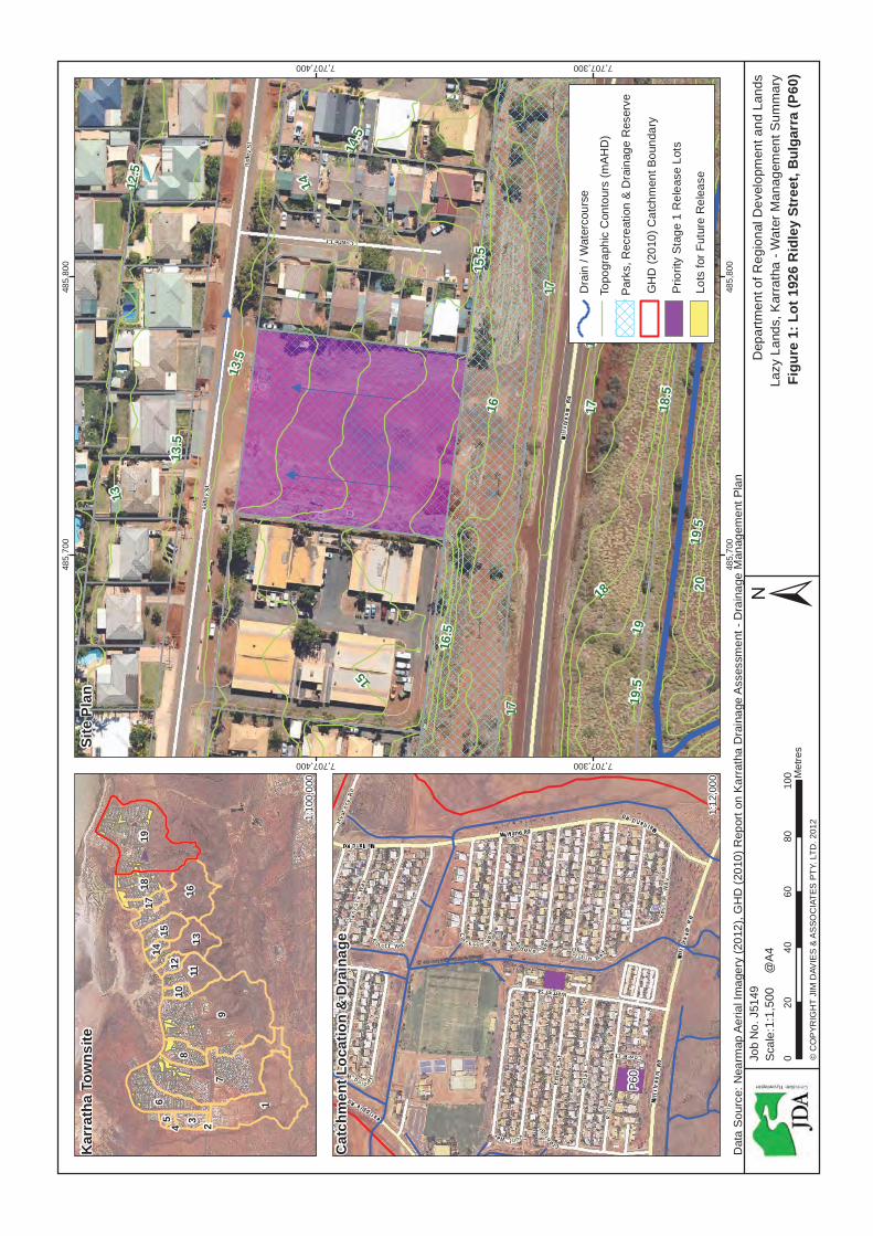
Referring to Figure 1, the Lot is 0.5 ha and located 2.0 km east of the Karratha City centre, within the
JDA Consultant Hydrologists
J5149g 19 September 2012 2
JDA
suburb of Bulgarra. The Lot is fronted by Ridley Street to the north Millstream Road to the south. There are existing residential buildings located adjacent to the Lot to the east and west.
Existing natural surface contours are shown on Figure 1 indicating the Lot has a south to north sloping gradient with elevations ranging from 16.0 mAHD to 13.5 mAHD respectively. Lot 1926 is part of a Parks, Recreation and Drainage reserve as shown on Figure 1.
3. Major Flood & Storm Surge
The draft Karratha Coastal Vulnerability Study (KCVS) prepared by JDA et. al. (2011) on behalf of LandCorp provides rainfall runoff, storm surge and associated flood level 2-Dimensional (2D) modelling and mapping across the Karratha region. The KCVS was produced to assist and inform future development of the Karratha region at a district scale level of detail. Modelling was undertaken for various climate scenarios including present day (2010) and 50 year (2060) and 100 year (2110). Note that flood levels (in mAHD) produced are based on regional scale modelling and are subject to refinement to the local scale.
Email advice from the Department of Water (DoW) on 10 September 2012 to the Shire of Roebourne is attached. This confirms that the natural surface of the Lot is greater than the 100 year Average Recurrence Interval (ARI) and 500 Year ARI water levels, from storm surge and catchment flooding, for the 2010, 2060 and 2110 climate scenarios from the draft KCVS. DoW notes that this advice is related to storm surge and major flooding only and does not take into account local stormwater drainage.
4. Catchment Drainage
Figure 1 shows that Lot 1926 is located at the midpoint of drainage Catchment 19, one of the larger catchments in the Karratha area (GHD, 2010). Lot 1926 is not located immediately adjacent to any open drainage channel. The closest open drainage channel is located approximately 320m to the east which is one the main drainage arteries in Catchment 19 (GHD, 2010).
5. Lot Drainage
Stormwater runoff from the Lot is directed toward Ridley Street which then flows to the east with the fall in road elevation. There is little contributing upstream catchment expected to influence the Lot and all local stormwater runoff is anticipated to be contained within the depth of the road kerb.
During development, it is envisaged that stormwater runoff will continue to discharge directly into the Ridley Street local road drainage system at the front of the Lot. Detail design of management of stormwater will be presented in a Stormwater Management Plan, required by the Shire of Roebourne, to be submitted with the Development Application. Criteria to be addressed include;
2D flood modelling 100 yr ARI water level in adjacent drain
Finished Lot level design
Local stormwater management
Runoff direction
Erosion control
JDA Consultant Hydrologists
J5149g 19 September 2012 3
JDA
6. Conclusions
For Major Flood & Storm Surge, DoW has advised that the natural surface of Lot 1926 is above the 100 year ARI and 500 year ARI events.
For Catchment Drainage, Lot 1926 is located within Catchment 19 (GHD, 2010) which is one of the larger catchments in the Karratha area. There are no adjacent open drainage channels.
For Lot Drainage, stormwater runoff is directed onto Ridley Street at the northern boundary of the Lot which then flows east within the width of the road extent. Stormwater runoff is anticipated to be contained within the depth of the road kerb.
A Stormwater Management Plan will be required by the Shire of Roebourne to support a future Development Application for Lot 1926.
This Water Management Summary supports the proposed Scheme Amendment and Rezoning from ‘Parks, Recreation & Drainage’ to ‘Urban’.
References
GHD (2010), Report on Karratha Drainage Assessment - Drainage Management Plan; for Shire of Roebourne JDA Consultant Hydrologists, GEMS, Damara WA, Coastal Zone Management & DHI Water & Environment (2011) Karratha Coastal Vulnerability Study (Draft); for LandCorp
If you have any queries, please do not hesitate to contact Matthew Yan or Damien Slack.
Yours sincerely,
JDA CONSULTANT HYDROLOGISTS DISCLAIMER
This document is published in accordance with and subject to an agreement between JDA Consultant Hydrologists (“JDA”) and the client for whom it has been prepared (“Client”), and is restricted to those issues that have been raised by the Client in its engagement of JDA. It has been prepared using the skill and care ordinarily exercised by Consultant Hydrologists in the preparation of such documents.
Any person or organisation that relies on or uses the document for purposes or reasons other than those agreed by JDA and the Client without first obtaining a prior written consent of JDA, does so entirely at their own risk and JDA denies all liability in tort, contract or otherwise for any loss, damage or injury of any kind whatsoever (whether in negligence or otherwise) that may be suffered as a consequence of relying on this document for any purpose other than that agreed with the Client.
14
15
16
17
19
18
13
15.5
14.5
13.5
16.5
18.5
17.5
12.5
2019
.5
13.5
17
19
17
19.5
485,
700
485,
700
485,
800
485,
800
7,707,300
7,707,300
7,707,400
7,707,400
Dep
artm
ent o
f Reg
iona
l Dev
elop
men
t and
Lan
dsLa
zy L
ands
, Kar
rath
a - W
ater
Man
agem
ent S
umm
ary
Figu
re 1
: Lot
192
6 R
idle
y St
reet
, Bul
garr
a (P
60)
±Jo
b N
o. J
5149
© C
OP
YRIG
HT
JIM
DAV
IES
& A
SSO
CIA
TES
PTY
. LTD
. 201
2
Dat
a S
ourc
e: N
earm
ap A
eria
l Im
ager
y (2
012)
, GH
D (2
010)
Rep
ort o
n K
arra
tha
Dra
inag
e A
sses
smen
t - D
rain
age
Man
agem
ent P
lan
020
4060
8010
0 Met
res
Sca
le:1
:1,5
00@
A4
97
1
196
168
18
1311
15
3
17
1210
145
4 2
Kar
rath
a To
wns
ite
Cat
chm
ent L
ocat
ion
& D
rain
age
1:10
0,00
0
1:12
,000
GH
D (2
010)
Cat
chm
ent B
ound
ary
Prio
rity
Sta
ge 1
Rel
ease
Lot
s
Topo
grap
hic
Con
tour
s (m
AH
D)
Par
ks, R
ecre
atio
n &
Dra
inag
e R
eser
ve
Site
Pla
n
Lots
for F
utur
e R
elea
se
Dra
in /
Wat
erco
urse
P60
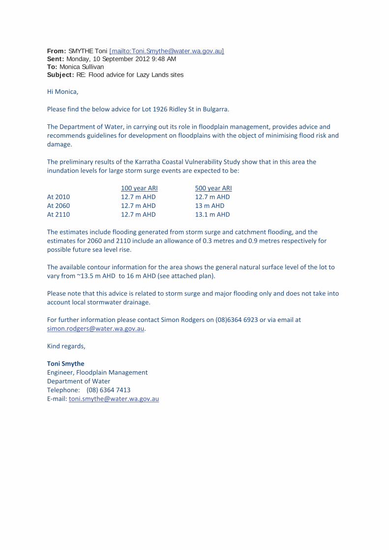
From: SMYTHE Toni [mailto:[email protected]]Sent: Monday, 10 September 2012 9:48 AM To: Monica Sullivan Subject: RE: Flood advice for Lazy Lands sites
Hi Monica,
Please find the below advice for Lot 1926 Ridley St in Bulgarra.
The Department of Water, in carrying out its role in floodplain management, provides advice andrecommends guidelines for development on floodplains with the object of minimising flood risk anddamage.
The preliminary results of the Karratha Coastal Vulnerability Study show that in this area theinundation levels for large storm surge events are expected to be:
100 year ARI 500 year ARIAt 2010 12.7 m AHD 12.7 m AHDAt 2060 12.7 m AHD 13 m AHDAt 2110 12.7 m AHD 13.1 m AHD
The estimates include flooding generated from storm surge and catchment flooding, and theestimates for 2060 and 2110 include an allowance of 0.3 metres and 0.9 metres respectively forpossible future sea level rise.
The available contour information for the area shows the general natural surface level of the lot tovary from ~13.5 m AHD to 16 m AHD (see attached plan).
Please note that this advice is related to storm surge and major flooding only and does not take intoaccount local stormwater drainage.
For further information please contact Simon Rodgers on (08)6364 6923 or via email [email protected].
Kind regards,
Toni SmytheEngineer, Floodplain ManagementDepartment of WaterTelephone: (08) 6364 7413E mail: [email protected]
15
16
14
13
12
17
19
18
11.5
15.5
14.5
13.5
16.5
12.5
18.5
17.5
19.5
20
11
2120
.5
17
13.5
19
17
1716
.5
19.5
RID
LEY
ST
MEL
AK
ST
MIL
LSTR
EAM
RD
COWRIE CT
1
680
1926
7
2
6
3
84
9
611
5
606
610
631
634
614
608
612
629
609
623
627
625
613
604
607
635
605
626
624
632
630
615
628
633
616
603
636
11
587
10
588
622
589
590
591
LEG
END
Lot 1
926
Rid
ley
StBu
lgar
ra
´
LOC
ALI
TY M
AP
# SK
AR
RA
THA
This
map
is a
pro
duct
of t
he D
epar
tmen
t of W
ater
,A
sses
smen
t & A
lloca
tion
and
was
prin
ted
on 7
/09/
2012
.
This
map
was
pro
duce
d w
ith th
e in
tent
that
it b
e us
edfo
r di
spla
y pu
rpos
es a
t the
sca
le o
f 1:1
,500
whe
npr
intin
g at
A4.
Whi
le th
e D
epar
tmen
t of W
ater
has
mad
e al
lre
ason
able
effo
rts to
ens
ure
the
accu
racy
of t
his
data
,th
e de
part
men
t acc
epts
no
resp
onsi
bilit
y fo
r any
inac
cura
cies
and
per
sons
rel
ying
on
this
dat
a do
so
at th
eir o
wn
risk.
SOU
RC
ES
Spa
tial C
adas
tral
Dat
abas
e - L
andg
ate
- 06/
02/1
2R
oad
Cen
trelin
es, D
LI -
Land
gate
- 13
/01/
2010
Wes
tern
Aus
tral
ian
Tow
ns -
Land
gate
- 1
2/07
/200
1
The
Dep
artm
ent o
f Wat
er a
ckno
wle
dges
the
follo
win
g da
tase
ts a
nd th
eir c
usto
dian
s in
the
prod
uctio
n of
this
map
:
Dat
um a
nd P
roje
ctio
n In
form
atio
nVe
rtica
l Dat
um: A
ustra
lian
Hei
ght D
atum
(AH
D71
)H
oriz
onta
l Dat
um: G
DA
94 M
GA
z50
Proj
ectio
n: U
nive
rsal
Tra
vers
e M
erca
tor (
UTM
)Sp
hero
id: G
eode
tic R
efer
ence
Sys
tem
(GR
S80
)
Proj
ect I
nfor
mat
ion
Clie
nt:
Map
Aut
hor:
Toni
Sm
ythe
Task
ID: B
1305
Com
pila
tion
date
: 7/0
9/20
12Ed
ition
: Ver
sion
1
Path
: J:\g
ispr
ojec
ts\P
roje
ct\B
_Ser
ies\
B130
5\00
01_F
PM_E
nqui
res\
mxd
\Kar
rath
a\FP
M K
arra
tha
Lot 1
926
Rid
ley
St e
nq.m
xd
Surfa
ce C
onto
urs
(m A
HD
)
Lot 1
926
Rid
ley
St
Cad
astre
010
2030
405
Met
res