appendix a - san jose, ca
TRANSCRIPT

APPENDIX A
GEOTECHNICAL INVESTIGATION


APPENDIX B
PHASE I ENVIRONMENTAL SITE ASSESSMENT FOR ARAUJO
STREET PROJECT


PHASE 1 ASSESSMENTS.C:ClM PROVIDING ENVIRONMENTAL CONSULTING FOR YOUR BUSINESS
EXECUTIVE SUMMARY
March 2, 2015
Mr. Vakili was retained by Mr. Tony Baig to conduct a Phase I Environmental Site Assessment Report at the portion of San Jose Municipal Golf Course located on the Araujo Street in a residential setting of City of San Jose, Santa Clara County pursuant to ASTM 1527-13 Standards for Environmental Site Assessment Reports. Any exceptions to, or deletion from this practice is described in Section 1.3 of the Phase I Environmental Site Assessment Report of March 2, 2015 (Report).
Property Description
The Subject Property is an approximately 25,000 square feet of a vacant land. This parcel of land has recently separated from the 1 00-acre San Jose Municipal Golf Course at 1560 Oakland Road in San Jose.
Findings
Recognized Environmental Conditions are defined by the ASTM Standard Practice E-1527 -13 as the presence or likely presence of any hazardous substances or petroleum products in, on, or at a property: 1) due to any release to the environment, 2) under conditions indicative of a release to the environment; or 3) under conditions that pose a material threat of a future release to the environment. De minimis conditions are not recognized environmental conditions. A release of any hazardous substance or petroleum product shall have the same meaning as the definition of "release" in CERCLA 42 U.S. C.§ 9601(22). This assessment has revealed no existing recognized environmental condition in connection with the Subject Property.
Historical Recognized Environmental Conditions
ASTM 1527-13 defines a past release of any hazardous substances or petroleum products that has occurred in connection with the property and has been addressed to the satisfaction of the applicable regulatory authority or meeting unrestricted residential use criteria established by a regulatory authority, without subjecting the property to any
273 Canyon 1-alls Dnvc Folsom, CA 95630
UmtcJ Stntcs of America
(916) 804-6232 (QI6) 988·6639
ph~ I a=~5rncnu.com

required controls (for example, property use restrictions, activity and use limitations, institutional controls, or engineering controls). Before calling the past release a historical recognized environmental condition, the Environmental Professional must determine whether the past release is a recognized environmental condition at the time the Phase I Environmental Site Assessment (ESA) is conducted. If the Environmental Professional considers the past release to be a recognized environmental condition at the time the Phase I ESA is conducted, the condition shall be included in the conclusions section of the report as a recognized environmental condition. This assessment has revealed no historical recognized environmental conditions in connection with the Subject Property.
Environmental issues
Environmental issues include environmental concerns identified by Mr. Vakili that warrant discussion but do not qualify as Recognized Environmental Conditions, as defined by the ASTM Standard Practice E-1527-13. Mr. Vakili found no environmental issues in association with the Subject Property.
Recommendations
We have performed the Report in conformance with the scope and limitations of ASTM Practice E-1527-13 for the Subject Property. Any exceptions to, or deletions from this practice are described in Section 1 of the Report. This assessment recommends no further investigation in connection with the Subject Property at this time.
Farshad Vakili, P.E. Environmental Engineer 273 Canyon Falls Drive Folsom, California 95630

PHASE I ENVIRONMENTAL SITE ASSESSMENT REPORT
VACANT LAND ARAUJO STREET PROJECT
SAN JOSE, SANTA CLARA COUNTY, CALIFORNIA
MARCH 2, 2015
PREPARED BY: FARSHAD T. VAKILI, P.E.
PRINCIPLE ENGINEER 273 CANYON FALLS DRIVE
FOLSOM, CALIFORNIA 95630
PREPARED FOR: TONY BAIG
VILLA DEVELOPERS AND INVESTMENT, LLC 2850 STEVENS CREEK BOULEVARD
SAN JOSE CALIFORNIA 95128

Phase I Environmental Site Assessment Report Vacant land at Araujo Street, San Jose, Santa Clara County, California March 2, 2015
TABLE OF CONTENTS
1. 1~1rFl()[)lJC1rl()~ •....•....••....•.............•...................•............................ 3
1.1. PURPOSE .................................................................................... 3
1.2. SCOPE OF SERVICE ........................................................................ 3 1.3. Limitations and Exceptions .............................................................. 3
1.4. Qualification ................................................................................. 4
2. SCOPE OF WORK ............................................................................. 5
3. SITE DESCRIPTION ........................................................................... 7
3.1. Location ..................................................................................... 7
3.2. ADJACENT PROPERTIES ................................................................... 7 3.3. Current Use ................................................................................. 7
3.4. SITE DESCRIPTION .......................................................................... 7 4. USER PROVIED INFORMATION ..••.•.•..•••.••••••••••••••••••.••••••••••.••.••••••••. 8
4.1. Title Records/Environmental Liens ................................................. 8
4.2. Owner and Property Manager lnformation ......................................... a !i. Fli:C:()fl[)!; Fll:\11~ ••...••...•••.•.•.•...•.•••.•..••••••••••••.••••••••••••.•.••••.•..•..•...••.. ~
5. 1. GEOLOGIC CONDITIONS .................................................................... 9 5.2. GENERAL HYDROGEOLOGY ............................................................... 9
5.3 RADON GAS AND ASBESTOS ............................................................... 9 5.4. REGIONALL CONDITIONS ................................................................. 1 0 5.5. Historical Use ............................................................................ 10
5.6. File Review .............................................................................. 10
6. SITE RECONNAISSANCE .................................................................... 12
5.1. SITE INSPECTION AND INTERVIEWS •••••.....•.........•.••.••••...••.•••.............• 12 5.2. SITE VICINITY ..................................................................................... 14
7. FINDINGS, OPINION AND RECOMMENDATION •••••••••••••••••..••...•.••...•••• 15
8. CONCLUSION AND CERTIFICATION •.••••••••••.•••...•..•.••...••••••••••.••••.•.•. 17
ATTACHMENTS
2

Phase I Environmental Site Assessment Report Vacant land at Araujo Street, San Jose, Santa Clara County, California March 2, 2015
1. INTRODUCTION
This report presents the results of a Phase I Environmental Site Assessment performed by Farshad Vakili, P.E., an independent environmental assessor/engineer on a vacant land located at Araujo Street in San Jose, Santa Clara County, California (Subject Property). The Subject Property was part of the San Jose Municipal Golf Course which is now a separated parcel of land.
This Report reveals the results from the review of regulatory agencies files, interview of appropriate people and site inspection of the Subject Property on February 26, 2015.
1.1 Purpose
The objectives of this Report is to evaluate whether there is evidence of an environmental impact to any of the environmental receptors such as human and/or wild life; or any environmental impacts to any environmental pathways such as surface, water, air, groundwater, and subsurface gas generation. Any potential environmental impacts resulted from past or present activities at the Subject Property or surrounding businesses, have been considered in this Report. All the extensive regulatory agencies files search which provide information on all the past, present and to some extent future impacts to the Subject Property and the surrounding area are noted in the Report.
1.2 Scope of Application
This Report is submitted to Mr. Tony Baig for distribution. The scope of the application is to determine any Recognized Environmental Conditions at the Subject Property.
1.3 Limitation and Exception
This Report has been prepared in accordance with generally accepted environmental methodologies referred to in ASTM 1527-13, and contains all of the limitations inherent in these methodologies. No other warranties, expressed or implied, are made as to the professional services provided under the terms of our contract and included in this Report. The conclusions of this Report are based in part, on the information provided by others. The possibility remains that unexpected environmental conditions may be encountered at the site in locations not specifically investigated. Should such an event occur, Mr. Vakili must be notified in order that he may determine if modifications are necessary. The services performed and outlined in this Report were based, in part, upon visual observations of the site and attendant structures. Our opinion cannot be extended to portions of the site that were unavailable for direct observation, reasonably beyond the control of Mr. Vakili. The objective of this report was to assess
3

Phase I Environmental Site Assessment Report Vacant land at Araujo Street, San Jose, Santa Clara County, California March 2, 2015
environmental conditions at the site, within the context of our contract and existing environmental regulations within the applicable jurisdiction. Evaluating compliance of past or future owners with applicable local, provincial and federal government laws and regulations was not included in our contract for services. Our observations relating to the condition of environmental media at the site are described in this Report. It should be noted that compounds or materials other than those described could be present in the site environment.
1.4 Qualification
Mr. Vakili is a registered professional engineer and a registered environmental assessor in the State of California. Mr. Vakili has thirty years of experience working for regulatory agencies and manufacturing facilities conducting complex environmental assessment, characterization and remediation projects. Mr. Vakili also conducted assessment projects for regulatory agencies preparing Resource Conservation and Recovery Act (RCRA) facility assessments reports for various industries throughout California in compliance with the California Department of Toxic Substances Control (OTSC) and United States Environmental Protection Agency laws and regulations. Mr. Vakili is currently a Senior Hazardous Substances Engineer at DTSC. Mr. Vakili has also conducted phase I environmental site assessment projects for residential, commercial as well as industrial properties as an independent consultant throughout California.
4

Phase I Environmental Site Assessment Report Vacanlland at Araujo Street, San Jose, Santa Clara County, Csllfomia March 2, 2015
2. SCOPE OF WORK
The scope of work for this Report is to provide information regarding the past and present activities at the Subject Property and the vicinity area. This Report has been performed in accordance with the Scope of Work pursuant to the requirements of the American Society for Testing and Materials (ASTM) Standards 1527-13 for environmental site assessments, and the United States Environmental Protection Agency's (USEPA) Resource Conservation and Recovery Act (RCRA) Facility Assessment for corrective action.
On Wednesday, November 6, 2013, ASTM International announced that it has officially approved and published the latest revision of its Phase I Environmental Site Assessment Protocol, E 1527-13, and Standard Practice for Environmental Assessments: Phase I Environmental Site Assessment Process. As reported in a prior post, United States Environmental Protection Agency (USEPA) issued both a direct final rule and a backup proposed rule on August 15, 2013, that would add a reference to the expected ASTM E 1527-13 in USEPA's All Appropriate Inquiries (AAI) regulations at 40 CFR 312.11 (c). Approximately forty comments were submitted, including adverse comments and therefore, on October 29, 2013, USEPA officially withdrew the direct final rule. USEPA expects the final rule incorporating a reference to the new version to be issued by the end of 2013. It should be noted that E 1527-13 is not officially recognized by USEPA as sufficient to meet AAI until USEPA issues its final rule. However, we are going use ASTM 1527-13 in this Report regardless per the request from the client. It will be prudent to require using E 1527-13 in phase I assessments once the USEPA rule change goes final. USEPA said conflicting things in the materials associated with the rule, for example it emphasized that approval of an additional version of the ASTM Standard would add flexibility (an additional option toE 1527-05), but it also made references to the greater "validity" of the new version of the standard. E 1527-05 will remain in the AAI Rule as acceptable, but there is a view that E 1527-13 is a clarification by ASTM of what ASTM intended in E 1527-05 all along, and, therefore, that compliance with E 1527-05 might be evaluated in the future by a court (in the inherently-after-the-fact determination characteristic of AAI and the landowner liability protections) through the lens of the more explicit language of E 1527-13.
After months of delays, rumors and speculation, the US EPA finally acknowledged that the newly revised ASTM Environmental Site Assessment standard, known as E1527-13, is consistent with the All Appropriate Inquires (AAI) rule. As described in the December 30, 2013 Federal Register announcement, the US EPA amended the AAI rule to reference ASTM E1527-13 as compliant with the standards and practices required to qualify for certain CERCLA liability protections as well as Brownfields grants. In fact, the US EPA now "strongly encourages" and "recommends that environmental professionals and prospective purchasers" use ASTM E1527-13 when conducting AAI compliant Phase I Environmental Site
5
Phase I Environmental Site Assessment Report Vacant land at Araujo Street, San Jose, Santa Clara County, Califomla March 2, 2015
Assessments to identify releases and threatened releases of hazardous substances at commercial and industrial properties.
It is worth noting that while the newly amended AAI rule does not remove reference to the previous ASTM standard (E1527 -05), "the Agency's intent will be to promote the use of the current industry standard and reduce confusion associated with the regulatory reference to a standard no longer recognized as current by ASTM International and no longer marketed by the standards development organization." The US EPA will publish an additional proposed rulemaking to remove the reference to the ASTM E1527-05 standard in the AAI rule sometime in the near future. Therefor this Report will be in compliance with ASTM 1527-13.
This work includes visual site inspection, interview of the responsible parties, review of the regulatory agencies' files and preparing this site assessment report. The regulatory agencies files include but not limited to:
• Review of Santa Clara County Health Department and City of San Jose Building Department
• Review of the California Department of Toxic Substances Control's STARS List, Multi-Data Base Search, Site Mitigation and Brownfield Reuse Program Database for Unconfirmed Referral, Voluntary Clean-Up, School, No Further Action, Needing Further Evaluation, Cal Site and Envirostor.
• Review of California Regional Water Quality Control Board
• Review of California Department of Resource Conservation and Recycling (CaiRecycle), List of Active and Inactive Landfills, and Used Oil Recycling Program
• Review of USEPA's RCRA info List for Federal Hazardous Waste Generators
6

Phase I Environmental Slte Assessment Report Vacant land at Araujo Street, San Jose, Santa Clara County, Cal!fomia March 2, 2015
3. SITE DECRIPTION
3.1 Location
The Subject Property is a vacant parcel of land located on Araujo Street in San Jose, Santa Clara County, California; east 1-880; immediately south of San Jose Municipal Golf Course. The Subject Property is located in a residential setting area in the City of San Jose. Attachment 1, Figure 1 is the Santa Clara County Assessor's Parcel Map. Attachment 1, Figure 2 is the Topographic Map. Attachment 1, Figure 3 is the Historical Photographs from 1939, 1940, 1948, 1950, 1956, 1968, 1974, 1982, 1993, 1998,2005,2006,2009, 2010 and 2012.
3.2 Adjacent Properties Current Use
The Subject Property is located on Araujo Street immediately south of San Jose Municipal Golf Course in a residential setting of City of San Jose, Santa Clara County. The Subject Property is surrounded San Jose Municipal Golf Course to the west, south and north, and residential homes to the east on Pietro Drive.
3.3 Current Use of the Subject Property
The Subject Property is currently a vacant land. The Subject Property has electricity/power, water, sewer and gas line the City of San Jose.
3.4 Site Description
The Subject Property is an approximately 25,000 square feet of a vacant land. This parcel of land has recently separated from the 1 00-acre San Jose Municipal Golf Course at 1560 Oakland Road in San Jose.
The land referred to herein is situated in the State of California, County of Santa Clara, City of San Jose and described as follows:
All that certain real property situated in the City of San Jose, County of Santa Clara, State of California, being a Portion of Parcel No. 5 as shown on the Record of Survey filed for Record in Book 220 of Maps, at Page 8-11, Records of Santa Clara County. The Santa Clara Assessor's Parcel Number is APN: 241-02-016 (Portion).
7

Phase I Environmental Site Assessment Report Vacant land at Araujo Street, San Jose, Santa Clara County, Califomla March 2, 2015
4. USER PROVIDED INFORMATION
4.1 Title Records/Environmental Liens
Mr. Vakili reviewed the February 27, 2014 Preliminary Title Report prepared by First American Title Company located at 455 North Santa Cruz Avenue in los Gatos and is not aware of any environmental cleanup liens against the Subject Property that are filed or recorded under federal, tribal, state or local law. Mr. Vakili is not aware of any AUls, such as engineering controls, land use restrictions or institutional controls that are in place at the site and/or have been filed or recorded in a registry.
4.2 Owner and Property Manager Information
The owner of the Subject Property is City of San Jose, a Municipal Corporation of the State of California.
4.3 Specialized Knowledge of the User
Mr. Vakili's research did not find any recognized environmental conditions in connections with the property prior to the site reconnaissance.
4.4 Actual Knowledge of the User
Mr. Vakili did not find any environmental liens in connection with the property.
4.5 Reason for Significantly Lower Purchase Price
Mr. Vakili did not find any evidence to identify lower price which does not reasonably reflect fair market value.
4.6 Commonly Known or Reasonably Ascertainable Information
Mr. Vakili is not aware of any commonly known or reasonably ascertainable information within local community about the property that is material to recognized environmental conditions.
8

Phase I Environmental Site Assessment Report Vacant land at Araujo Street, San Jose, Santa Clara County, California March 2. 2015
5. RECORD REVIEW
5.1 Geologic Conditions
The Subject Property is located in the City of San Jose; Santa Clara County. The Hayward fault is one of the most hazardous faults in the United States, because of its high slip rate, its demonstrated ability to generate a large earthquake and, importantly, its location through the highly urbanized eastern San Francisco Bay area.
The underlying soil is an unconfined, low-permeability water-bearing zone that occurs from the ground surface to a depth to the groundwater. It consists primarily of fine grained sand and clay. The bottom of this area is defined by a clay layer, which is typically 6 to 16 feet thick, however this clay layer has been encountered to as much as 60 feet beneath the area. This clay layer serves as an aquitard and impedes flow. Please see Attachment 2 for more information.
5.2 General Hydrogeology
Regional groundwater flow is westward toward San Francisco Bay, while local groundwater flow is toward the southwest. The groundwater depth is between 20-25 feet below ground surface. Please see Attachment 2 for more information.
5.3 Radon, Asbestos Containing Materials, Lead-Based Paint and Naturally Occurring Asbestos (NOA)
Radon gas is a radioactive gas found throughout the United States that cannot be seen, tasted or smelled. It can move up through the ground and into a home through cracks and holes in the foundation and can build up to high levels. Radon also can get into indoor air when released from water. Radon entering the home through tap water, in most cases, is small source in indoor air compared to radon entering home from soil. USEPA has determined that radon is a known human carcinogen and breathing air-containing radon may cause increased risk of stomach cancer. No evidence of radon gas detected at levels of concern (greater than 4.0 pCi/L) per any investigation at the Santa Clara County. Most homes in Santa Clara County do not have basements.
Geologic maps prepared by the California Geologic Survey show areas of higher probability for asbestos containing rocks within the broad zone of faults that follows the low foothills and lay in a south-east to north-west band. There are some isolated areas of higher probability for the presence of NOA within Tahoe National Forest and El Dorado Hills. No asbestos stone was observed at the property during February 26, 2015 inspection. Also, there is no possibility of the asbestos containing materials (ACM) in the insulation and lead-based paint (LBP) in the paint, because there is no structure at the Subject Property.
9

Phase I Environmental Site Assessment Report Vacant land at Araujo Street, San Jose, Santa Clara County, California March 2, 2015
5.4 Regional Conditions
San Jose Municipal Golf Course has been called home to thousands of south bay golfers. With an easy access location near the major Freeways such as Highway 101, Highway 880, and Highway 280, this golf course has become very popular to the regional golfers.
5.5 Historical Use
Historical Aerial Photographs from 1939, 1940, 1948, 1950, 1956, and 1968 showed that the entire area was an agricultural land. Historical Aerial Photographs from 1974 and 1982 showed that the property was still as an agricultural land while the vicinity area was being developed. Historical Aerial Photographs from 1993, 1998, 2005, 2006, 2009, 2010 and 2012 showed that the Subject Property was a vacant land but part of the San Jose Municipal Golf Course. Please see Attachment 1, Figure 3 for all the historical photographs.
According to the historical file searches, the Subject Property was used for agricultural use from 1920s-1980s, and was part of San Jose Municipal Golf Course from late 1980s to the present. It should be noted that although the property was part of the golf course, it never got utilized by the golf course.
5.6 File Review
Environmental Data Resources, Inc., Radius Map Report of February 27, 2015 and regulatory agencies file review included in this Report for the Subject Property and the vicinity area (Attachment 4 ). It included the review of:
Deparbnent of Resource Conservation and Recycling (CaiRecycle), Solid Waste Information System (SWIS) and Used Oil Recycling Program
According to the CaiRecycle, there is no facility within 0.5 miles of the Subject Property.
Environmental Protection Agency, Deparbnent of Toxic Substances Control (DTSC), STARS List, Multi-Data List, HWTS List, Site Mitigation and no Brownfield& Reuse Program, Cal Site List, Properties Needing Further Action, School Property Evaluation List, Voluntary Cleanup Program and Envirostor
There are sites on the Envirostor within 1 mile of the Subject Property in higher elevation including Komag, Inc. (1705 Automation Parkway, needs evaluation, no immediate threat), WD Media LLC (1710 Automation Parkway, needs evaluation, no immediate threat), Elcon Precision LLC (1 009 Timothy Drive, active, no immediate threat), Ocular Labs (923 Berryessa Road, needs evaluation, no
10

Phase I Environmental Site Assessment Report Vacant land at Araujo Street, San Jose, Santa Clara County, Califomia March 2, 2015
immediate threat), Cherry Acres Partnership (1671 Mabury Road, No Further Action), Adaptive Circuits (1565-A Mabury Road, needs evaluation, no immediate threat),and Control Data Corporation (967 Mabury Road, needs evaluation, no immediate threat).
There are other hazardous waste storage, disposal or treatment facilities in the vicinity of the Subject Property including Clean Harbor San Jose (1 021 Berryessa Road, permitted, no immediate threat).
California Regional Water Quality Control Board (RWQCB), Leaking Underground Fuel Tank Report (LUFT), Underground Storage Tank and Geo Tracker
There are facilities on the Regional Water Quality Control Board list containing LUFT which are within 0.5 miles in the higher elevation of the Subject Property including Chan Nursery (1250 Townsend Park Circle, case closed), K. Tanaka Nursery (1472 Lundy Avenue, case closed), North Village Phase I (1590 Berryessa Road, case closed), Facchino Freight Lines (1655 Berryessa Road, case closed), Shell (1705 Berryessa Road, case closed), BC Auto Care (1715 Berryessa Road, case closed), Chan Nursery (1250 Townsend Park Circle, lower elevation, no impact), Mike Rawiter Golf Shop (1560 Old Oakland Road, lower elevation, no impact), and Western Pacific Railroad (900 East Williams, inactive, no impact).
Also, the Facility Inventory Database contain active and inactive underground storage tank within 0.25 miles of the Subject Property including Yamada Brothers (1449 Lundy Avenue), Chan Nursery (1250 Townsend Park Circle), and John Luccheti (1280 Lundy Avenue). The underground storage tanks will not pose any threat to the Subject property because they have secondary containments.
Santa Clara County Environmental Health Department
This agency refers all the potential contaminated sites to the state agencies. This agency has a list known as contaminated sites which identified no additional facility within 1.0 mile of the Subject Property.
11

Phase 1 Environmental Site Assessment Report Vacant land at Araujo Stteet, San Jose, Santa Clara County, California March 2, 2015
6. SITE RECONNAISSANCE AND INTERVIEWS
6.1 Site Inspection and Interview
Mr. Vakili inspected the Subject Property on February 26, 2015. The Subject Property included a vacant land recently separated from San Jose Municipal Golf Course. Mr. Vakili met with Mr. Tony Baig at the site. Mr. Baig indicated that he is purchasing the land from the City of San Jose, and he is intending to build townhouses at the property. Mr. Vakili inspected the property and did not find any Recognized Environmental Conditions. The property is a vacant land with no structure.
There is no possibility of asbestos containing materials and lead-based paint since there are no structures on the Subject Property. No stain or distressed vegetation was noticed at the Subject Property at the time of the inspection.
Roads
No road at the property was detected during February 26, 2015 inspection.
Potable Water Supply
Potable water on the property is supplied by the municipal water supply.
Sewage
There was a sewage system noticed during the inspection of February 26, 2015.
Hazardous Substances and Petroleum Products in Connection with Identified Uses
No hazardous substances in tanks and containers/drums were observed to be stored or used on the property during the inspection of February 26, 2015.
Storage Tanks
Determining the presence of Aboveground Storage Tanks (ASTs) and underground storage Tanks (USTs) is considered essential in assessing potential contamination sources. Visual inspection and the review of tank registration are used to determine the possible existence of past and present storage tanks in the area of the Subject Property. It must be noted however, that the absence of certain site conditions or lack of records may restrict or prevent the determination of the number and contents of storage tanks on the Subject Property. No aboveground storage tanks or underground storage tanks connections were observed on the
12

Phase I Environmental Site Assessment Report Vacant land at Araujo Street, San Jose, Santa Clara County, California March 2, 2015
Subject Property during the inspection of February 26, 2015.
Odors
No strong, pungent or noxious odors were observed during February 26, 2015 inspection.
Pools of Liquid
No vernal pools and seasonal wet lands were observed at the Subject Property during March 21, 2014 inspection.
Drums
No drums or containers of hazardous wastes or materials were observed during February 26, 2015 inspection.
Hazardous Substances and Petroleum Products Containers
No containers with hazardous materials or petroleum products that might represent a recognized environmental condition were observed on the property during February 26, 2015 inspection.
Unidentified Substance Containers
No open or damaged containers containing unidentified substances suspected of being hazardous substances or petroleum products were observed on the Subject Property during February 26, 2015 inspection.
Heating/Cooling
No heating or cooling was noticed at February 26, 2015 inspection.
Stains or Corrosion
There were no stains or corrosion on the ground during February 26, 2015 inspection.
Drains and Sumps
No drains or sumps were observed at the property during February 26, 2015 inspection.
13

Phase I Environmental Site Assessment Report Vacant land at Araujo Straet, San Jose, Santa Clara County, Califomla March 2, 2015
Pits, Ponds, or Lagoons
No pits, ponds or lagoons were observed at the property during February 26, 2015 inspection with the exception of the golf course lagoon. No concern was noted.
Stained Soil or Pavement
No areas of stained soil were observed during February 26, 2015 inspection.
Stressed Vegetation
No areas of stressed vegetation were observed on the property during February 26, 2015 inspection.
Solid Waste
No areas, mounds, or depressions that may be filled or graded by non-natural causes or filled with fill of unknown origin suggesting trash or other solid waste disposal were observed on the property during February 26, 2015 inspection.
WasteWater
There was no wastewater or other liquids being discharged into a drain, ditch, underground injection system, or stream on or adjacent to the property during February 26, 2015 inspection.
Wells
No wells were observed on the property during February 26, 2015 inspection.
Septic Systems
No septic systems or cesspools were observed on the property.
6.2 Site Vicinity
The Subject Property is located in a residential area of the City of San Jose. San Jose is the third-largest city in California, the tenth-largest in the United States. San Jose is the largest city within the San Francisco Bay Area and the largest city in Northern California. By the 1990s, San Jose's location within the booming local technology industry earned the city the nickname "Capital of Silicon Valley''. San Jose is now considered to be a global city and notable for its affluence, and high cost of living. The U.S. Census Bureau estimated the population of the city to be 998,537 as of July 1, 2013.
14

Phase I Environmental SHe Assessment Report Vacant land at Araujo Street, San Jose, Santa Clara County, California March 2, 2015
7. FINDINGS, OPINION AND RECOMMENDATION
At the request of Mr. Tony Baig.; Mr. Vakili completed this Report on the Subject Property. The Subject Property is an approximately 25,000 square feet of a vacant land. This parcel of land has recently separated from the 1 00-acre San Jose Municipal Golf Course at 1560 Oakland Road in San Jose. The assessment of the Subject Property included review of the regulatory agencies files relevant to any releases to the environment, conducting visual site inspection on February 26, 2015, surveillance of the surrounding area, and providing the findings in this Report.
No direct evidence was discovered to indicate that soil, groundwater or surface water contamination is present, or likely to be present beneath the Subject Property as result of operations of former owners at the Subject Property or other businesses in the neighborhood. Also, during the visual site inspection of February 26, 2015, no vegetation distress was observed (Please see Photographs of the Subject Property). The Subject Property is not on regulatory agencies files.
Historical Aerial Photographs from 1939, 1940, 1948, 1950, 1956, and 1968 showed that the entire area was an agricultural land. Historical Aerial Photographs from 197 4 and 1982 showed that the property was still as an agricultural land while the vicinity area was being developed. Historical Aerial Photographs from 1993, 1998, 2005, 2006, 2009, 2010 and 2012 showed that the Subject Property was a vacant land but part of the San Jose Municipal Golf Course.
We inspected the Subject Property on February 26, 2015. Please see the Photographs in the Attachment 3. We did not observe any condition that raises concern. No Recognized Environmental Conditions are presently found at the Subject Property.
The new Standard indicates the need to clarify that the potential for vapor migration must be considered in the Phase I report. The definition of "migrate" now expressly includes releases that migrate in the subsurface as vapor. Mr. Vakili does not believe that there is a need to assess possible indoor air quality impacts from vapor intrusion pathways because the subsurface soil may not have potentially been impacted.
The following documents, maps, or other publications may have been used in the preparation of this Report.
• American Society for Testing and Materials Standard Practice for Environmental Site Assessments: Phase I Environmental Site Assessment Process (ASTM E1527-05).
• American Society for Testing and Materials Guide for Environmental Site
15

Phase I Environmental Site Assessment Report Vacant land at Araujo Street, San Jose, Santa Clara County, California March 2, 2015
Assessments: Transaction Screen Process (ASTM E1528).
• Comprehensive Environmental Response, Compensation, and Liability Act of 1980 ("CERCLA" or "Superfund"), as amended by Superfund Amendments and Reauthorization Act of 1986 ("SARA") and Small Business Liability Relief and Brownfields Revitalization Act of 2002 ("Brownfield Amendments"), 42 U.S.C. §§9601, et. seq. • Resource Conservation and Recovery Act, as amended ("RCRA"), 42 U.S.C. §6901, et. seq.
• Federal Emergency Management Agency, National Flood Insurance Program, Flood Insurance Maps.
• United States Department of Agriculture, Soil Conservation Service, Soil Surveys.
• United States Geological Survey, Topographic Maps.
• United States Department of the Interior, Fish and Wildlife Service, National Wetlands Inventory Map
• RWQCB Geotracker
• DTSC Envirostor
• EDR Report, February 27,2015
• 2014 Annual Groundwater Monitoring Report for Clean Harbors San Jose, 1021 Berryessa Road, San Jose, dated January 29, 2015, prepared by CameronMCole
• San Jose City Web Page
• City of San Jose 5MYear Plan
16

Phase I Environmental Site Assessment Report Vacant land at Araujo Street, San Jose, Santa Clara County. California March 2, 2015
8. CONCLUSION AND CERTIFICATION
We have performed this Phase I Environmental Site Assessment in conformance with the scope and limitations of ASTM Practice E1527 for the Subject Property. Any exceptions to, or deletions from, this practice are described in Section 1 of this Report. This assessment has revealed no evidence of Recognized Environmental Conditions in connection with the Subject Property.
Except for the limitations and exceptions discussed in Section 1.3, this Report complies with the ASTM Standard 1527-05. No additional services beyond the scope of the ASTM Standard 1527-05 were conducted as part of this Report.
This is to certify that based on the assessment of the Subject Property, review of all regulatory agencies files, and a visual site inspection; we hereby recommend no further action at the Subject Property. This means that no additional assessment or investigation is necessary at this time.
Data failure occurs when all the standard historical sources that are reasonably ascertainable and likely to be useful have been reviewed and yet the objectives have not been met. If the data failure represents a significant data gap, the report shall comment on the impact of the data gap on the ability of the environmental professional to identify recognized environmental conditions. Mr. Vakili did not find any significant data failure that would impact of the data gap on the ability of Mr. Vakili to identify recognized environmental conditions.
The recommendation is based on the review of the regulatory agencies files, the inspection of the area around the Subject Property, the understanding of the status of nearby known or potentially contaminated sites, the distance from the known or potentially contaminated sites to the Subject Property, and the hydrogeological conditions of the subsurface soil and groundwater. Although there is no evidence of soil or groundwater contamination at the Subject Property at this time, it should be noted that there is always a potential of contamination from sources unknown to the regulatory agencies and Mr. Vakili at the time of this Report.
17

Phase I Environmental Site Assessment Report Vacant land at Araujo Street, San Jose, Santa Clara County, Cal ifornia March 2, 2015
We declare that, to the best of our professional knowledge and belief, we meet the definition of Environmental Professional as defined in §312.1 0 of 40 CFR 312. We have the specific qualifications based on education, training, and experience to assess a property of the nature, history, and setting of the Subject Property. We have developed and performed the all appropriate inquiries in conformance with the standards and practices set forth in 40 CFR Part 312.
Farshad Vakili, P.E. Principal Engineer 273 Canyon Falls Drive Folsom, California 95630
Date:
18

Phase I Environmental Site Assessment Report Vacant land at Araujo Street, San Jose, Santa Clam County, California March 2, 2015
ATTACHMENT 1 FIGURES

Phase I Environmental SHe Assessment Report Vacant land at Araujo Street, San Jose, Santa Clara County, Callfomla March 2, 2015
FIGURE 1 SANTA CLARA COUNTY ASSESSOR'S PARCEL MAP

~ ~~ ~§. '-'.:5
~ Ql
o''•ct o, cou,.r.,
PrN 500 AC LOt 30
@ --- ---~----------------f tolN :
I I
I ~
Nos cRO/B
tG I
' I Crty OF BAN JOSE
' - - - - - - .!1!•- ... ---- ... ~
lf.'r /
' 14
·~ ,,. '
Ali__ ! JJ ~-. ~ 7,1
f
- ~ - i!fl AC N(J TOJA~
PCL. 4
I I I I I I
Pet. s
•' i'
PCL. J
~4Q 4C llltl
.f
'"'"
®
®
CALr,o~tfiA
GrJcn ® 'if'
~~/ \
'to @)
\\ }} It
~ @I .. , ., ... , ..
-···-···-···11 ® ~A----··· JJJII •·•···· I
.PeL····. f :0 ·"=~-~- PTN__ecL. ' :!'le~~: - ~ ~~Jl
_ji··. fj1 ,{:4'~ -; i§
I t. I
~~
~
..... •nn _ -----.,- mmm
- - - ---. '{41) @) @ @)
-

Phase I Environmental Site Assessment Report Vacant land at Araujo Street, San Jose, Santa Clara County, carlfomia March 2, 2015
FIGURE 2 TOPOGRPAHIC MAP

// Targe t Property
• SlteG at elevatlonG higher than or equal to \he target property
• Site& at elevations lower than the target property
!. Manulacrurod Gas Plants
[] National Priority Ust Sitos
l Dept. Delonso Sitos
SITE NAME: Vacant Land ADQRESS: Arau\o Street
San Jose CA 95131 \..AT/LONG: 37.3793/ 121.8815
OVERVIEW MAP - 4219766.25
0 11• 1n ;;;;;;,;;;iiiiiii.iiii.._..J-~~--...iiiiiOoiiiiiiiiiiiiiiiiiiiiiiiiiiiiiiiiiiiiiiiiiiiiiiiiiiiiiiiiiiiiiiiiiiiiii~
1
u11
co Indian Reservations BIA
Oil & Gas pipelines from USGS ,----Lc...l 100 -year flood zone
0 500 -year flood zone
I:::J National WoUand Inventory
Areas ol Concern
T~is report Includes Interactive Map Layers to dtsplay.and/or hide map informallon. The legend mcludes only those Icons for the default map view.
CLIENT: Farshad Vakili, P.E., Phase 1 Assessment l CONTACT: Farshad Vakili, P.E. INQUIRY 1/: 4219766.2s DATE: February 27,2015 12:45 pm
CO~'I'~hl 201HOR In<. c 2010 Tolo Atlu Rtl 0712009

Phase I Environmental Site Assessment Report Vacant land at Araujo Street, San Jose, Santa Clara County, California March 2, 2015
FIGURE 3 HISTORICAL AERIAL PHOTOGRAPHS

Vacant Land
Araujo Street
San Jose, CA 95131
Inquiry Number: 4219766.5
March 02, 2015
~EDR" 6 Armstrong Road. 4th Floor SMilon. Connocl lcut 06484 Toll Free: 800.352 0050 www odrnot com

EDR Aerial Photo Decade Package
Environmental Data Resources, Inc. (EDR) Aerial Photo Decade Package is a screening tool designed to assist environmental professionals in evaluating potential liability on a target property resulting from pas~ activities. ~DR's professional researchers provide digitally reproduced historical aerial photographs, and when available, provide one photo per decade.
When delivered electronically by EDR, the aerial photo Images Included with this report are for ONE TIME USE ONLY. Further reproduction of these aerial photo Images Ia prohibited without permission from EDR. For more Information contact your EDR Account Executive.
Thank you for your business. Please contact EDR at 1-800-352-0050
with any questions or comments.
Disclaimer - Copyright and Trademark Notice
This Report contains certain infonnation obtained from a variety of public and other sources reasonably available to Environmental Data Resources, Inc. It cannot be concluded from this Report that coverage infonnation for the target and surrounding properties does not exist from other sources. NO WARRANTY EXPRESSED OR IMPLIED, IS MADE WHATSOEVER IN CONNECTION WITH THIS REPORT. ENVIRONMENTAL DATA RESOURCES, INC. SPECIFICALLY DISCLAIMS THE MAKING OF ANY SUCH WARRANTIES, INCLUDING WITHOUT LIMITATION, MERCHANTABILITY OR mNESS FOR A PARTICULAR USE OR PURPOSE. ALL RISK IS ASSUMED BY THE USER. IN NO EVENT SHALL ENVIRONMENTAL DATA RESOURCES, INC. BE UABLE TO ANYONE, WHETHER ARISING OUT OF ERRORS OR OMISSIONS, NEGLIGENCE, ACCIDENT OR ANY OTHER CAUSE, FOR ANY LOSS OF DAMAGE, INCLUDING, WITHOUT LIMITATION, SPECIAL, INCIDENTAL, CONSEQUENTIAL, OR EXEMPLARY DAMAGES. ANY LIABILITY ON THE PART OF ENVIRONMENTAL DATA RESOURCES, INC. IS STRICTLY LIMITED TO A REFUND OF THE AMOUNT PAID FOR THIS REPORT. Purchaser accepts this Report AS IS. Any analyses, estimates, ratings, environmental risk levels or risk codes provided In this Report are provided for Illustrative purposes only, and are not Intended to provide, nor should the\ be Interpreted as providing any facts regarding, or prediction or forecast of, any environmental risk for any property. Only a Phase I Environmental Site Assessment perfonned by an environmental professional can provide infonnation regarding the environmental risk for any property. Additionally, the information provided In this Report Is not to be construed as legal advice.
Copyright 2015 by Environmental Data Resources, Inc. All rights reserved. Reproduction In any media or fonnat, in whole or in part, of any report or map of Environmental Data Resources, Inc .. or its affiliates, is prohibited without prior written pennission.
EDR and its logos (Including Sanborn and Sanborn Map) are trademarks of Environmental Data Resources, Inc. or Its affiliates. All other trademarks used herein are the property of their respective owners.

Date EDR Searched Historical Sources: Aerial Photography March 02, 20 IS
Target Property: Araujo Street
San Jose, CA 95131
Xflll: ~
1939 Aerial Photograph. Scale: 1"=500'
1940 Aerial Photograph. Scale: I "=SOO'
1948 Aerial Photograph. Scale: 1"=500'
1950 Aerial Photograph. Scale: 1"=500'
1956 Aerial Photograph. Scale: 1".,500'
1968 Aerial Photograph. Scale: 1"=500'
1974 Aerial Photograph. Scale: 1""'500'
1982 Aerial Photograph. Scale: I ""'500'
1993 Aerial Photograph. Scale: l"=SOO'
1998 Aerial Photograph. Scale: 1" .. 500'
2005 Aerial Photograph. Scale: 1"=500'
2006 Aerial Photograph. Scale: I "c500'
2009 Aerial Photograph. Scale: t"c500'
2010 Aerial Photograph. Scale: 1" ... 500'
2012 Aerial Photograph. Scale: 1"=500'
!kJJdJs.
Flight Year: 1939
Flight Y car: 1940
Flight Year: 1948
Flight year: 1950
Flight Year: 1956
Flight Year: 1968
Flight Year: 1974
Flight Year: 1982
Flight Year: 1993 Best Copy Available from original source
/DOQQ ·acquisition dates: 1998
Flight year. 2005
Flight Year: 2006
Flight Year: 2009
Flight Year: 2010
Flight Year: 2012
4219766.5 2
~
USGS
USGS
USGS
USGS
USGS
USGS
USGS
USGS
USGS
USGS/DOQQ
USDAINAIP
USDNNAIP
USDNNAIP
USDNNAIP
USDNNAIP

4219766.5
1939

YEAR:
INQUIRY#:
1940
4219766.5
~N ~EOR"
1--- ---,1 = 500'

YEAR: 1948 ~EDR' L_ ___ _,, = 500'
INQUIRY#: 4219766.5
YEAR: _1.:...:9:..:.5.:..0 ___ _
~----,1 = 500'

INQUIRY#: 4219766.5
YEAR: 1956 --------itN ~EOR"


YEAR: 197 4 ~EDR' 1----~1 = 500'

INQUIRY #: 4219766.5
YEAR: 1982 ~EoR·
L-- ----j = 500'
INQUIRY #: 4219766.5 ~ N YEAR: 1993 ~EDR" 1...._ ___ --ll = 500'


#. 4219766.5 INQUIRY ·
@'EOR' YEAR: 20JU0~5___ ~·
= 500'


YEAR: _:2::..:00:..:.9 ___ _
1------,1 = 500'


41'
4219766.5
YEAR: 2012
1---.,
•J :-ll.

Phase I Envlronmenlal Site Assessment Report Vacant land at Araujo Street, San Jose, Sanla Clara County, California March 2, 2015
ATTACHMENT 2 SOIL, GROUNDWATER AND RADON GAS REPORT
GEOCHECK ®.PHYSICAL SETTING SOURCE ADDENDUM
TARGET PROPERTY ADDRESS
VACANTLANO ARAUJO STREET SAN JOSE, CA 95131
TARGET PROPERTY COORDINATES
Latitude (North): Longitude (West): Universal Tranverse Mercator: UTM X (Meters): UTM Y (Meters): Elevation:
USGS TOPOGRAPHIC MAP
Target Property Map: Most Recent Revision:
East Map: Most Recent Revision:
Southeast Map: Most Recent Revision:
South Map: Most Recent Revision:
37.3793- 37' 22' 45.48" 121.8815- 121' 52' 53.40" Zone 10 599027.3 4137333.5 77 ft. above sea level
37121-08 MILPITAS, CA 1980
37121-07 CALAVERAS RESERVOIR, CA 1980
37121-c7 SAN JOSE EAST, CA 1980
37121-cB SAN JOSE WEST, CA 1980
EOR's GeoCheck Physical Setting Source Addendum is provided to assist the environmental professional in forming an opinion about the impact of potential contaminant migration.
Assessment of the impact of contaminant migration generally has two principal investigative components:
1. Groundwater flow direction, and 2. Groundwatar flow velocity.
Groundwater flow direction may be impacted by surface topography, hydrology, hydrogeology, characteristics of the soil, and nearby wells. Groundwater flow velocity is generally impacted by the nature of the geologic strata.
TC4219766.2s Page A-1

GEOCHEC~ -PHYSICAL SETTING SOURCE SUMMARY
GROUNDWATER FLOW DIRECTION INFORMATION Groundwater flow direction for a particular site is best determined by a qualified environmental professional using site-specific well data. If such data is not reasonably ascertainable, it may be necessary to rely on other sources of information, such as surface topographic information, hydrologic information, hydrogeologic data collected on nearby properties, and regional groundwater flow information (from deep aquifers).
TOPOGRAPHIC INFORMATION Surface topography may be indicative of the direction of surficial groundwater flow. This information can be used to assist the environmental professional in forming an opinion about the impact of nearby contaminated properties or, should contamination exist on the target property, what downgradient sites might be Impacted.
TARGETPROPERTYTOPOGRAPHY General Topographic Gradient General West
SURROUNDING TOPOGRAPHY: ELEVATION PROFILES
~
s. c 0 := !: .!! w
g c 0
.. :l 0
North
~ 1!1 1:: .. :l !!! N
l w e._ ,!0_. ~. -~ _ .~:_. _m. = ;J
West
Target Property Elevation: 77ft.
Ul
... ..
... ...
TP
TP 0
... .. ::1 ::1 Ul ... ... Ul
.. .. N
:
... ... ...
... ~ ..
South
=·-·-·-·-·-·-·-·-·-·
East
1/2 1 Miles
Source: Topography has been determined from the USGS 7.5' Digital Elevation Model and should be evaluated on a relative (not an absolute) basis. Relative elevation information between sites of close proximity should be field verified.
TC4219766.2s Page A-2

GEOCHEC~ -PHYSICAL SETTING SOURCE SUMMARY
HYDROLOGIC INFORMATION
Surface water can act as a hydrologic barrier to groundwater flow. Such hydrologic information can be used to assist the environmental professional in forming an opinion about the impact of nearby contaminated properties or, should contamination exist on the target property, what downgradient sites might be Impacted.
Refer to the Physical Setting Source Map following this summary for hydrologic information (major waterways and bodies of water).
FEMA FLOOD ZONE
Target Property County SANTA CLARA, CA
Flood Plain Panel at Target Property:
Additional Panels in search area:
NATIONAL WETLAND INVENTORY
NWI Quad at Target Property MILPITAS
HYDROGEOLOGIC INFORMATION
FEMAFiood Electronic Data YES - refer to the Overview Map and Detail Map
06085C - FEMA DFIRM Flood data
Not Reported
NWI Electronic Data Coverage YES - refer to the Overview Map and Detail Map
Hydrogeologic information obtained by installation of wells on a specific site can often be an indicator of groundwater flow direction In the Immediate area. Such hydrogeologic Information can be used to assist the environmental professional In forming an opinion about the impact of nearby contaminated properties or, should contamination exist on the target property, what downgradient sites might be impacted.
Site-Specific Hydrogeological Data•: Search Radius: 1.25 miles Status: Not found
AQUIFLOW&
Search Radius: 1.000 Mile.
EDR has developed the AQUIFLOW Information System to provide data on the general direction of groundwater flow at specific points. EDR has reviewed reports submitted by environmental professionals to regulatory authorities at select sites and has extracted the date of the report, groundwater flow direction as determined hydrogeologlcally, and the depth to water table.
MAPID Not Reported
LOCATION FROMTP
GENERAL DIRECTION GROUNDWATER FLOW

GEOCHECI(!l> • PHYSICAL SETTING SOURCE SUMMARY
GROUNDWATER FLOW VELOCITY INFORMATION
Groundwater flow velocity information for a particular site is best determined by a qualified environmental professional using site specific geologic and soil strata data. If such data are not reasonably ascertainable, it may be necessary to rely on other sources of information, including geologic age Identification, rock stratigraphic unit and soil characteristics data collected on nearby properties and regional soil information. In general, contaminant plumes move more quickly through sandy-gravelly types of soils than silty-clayey types of soils.
GEOLOGIC INFORMATION IN GENERAL AREA OF TARGET PROPERTY Geologic information can be used by the environmental professional in forming an opinion about the relative speed at which contaminant migration may be occurring.
ROCK STRATIGRAPHIC UNIT GEOLOGIC AGE IDENTIFICATION
Era: Cenozoic Category: Stratlfed Sequence System: Quatemary Series: Quatemary Code: Q (decoded above as Era, System & Sarles)
Geologic Age and Rock Stratigraphic Unit Source: P.G. Schruben, R.E. Amdt and W.J. Bawiec, Geology of the Conterminous U.S. at 1:2,500,000 Scale- a digital representation of the 1974 P.B. King and H.M. Beikman Map, USGS Digital Data Series DOS· 11 (1994).
DOMINANT SOIL COMPOSmON IN GENERAL AREA OF TARGET PROPERTY
The U.S. Department of Agriculture's (USDA) Soil Conservation Service (SCS) leads the National Cooperative Soil Survey (NCSS) and Is responsible for collecting, storing, maintaining and distributing soil survey information for privately owned lands in the United States. A soli map in a soli survey is a representation of soil pattems In a landscape. Soil maps for STATSGO are complied by generalizing more detailed (SSURGO) soil survey maps. The following information is based on Soil Conservation Service STATSGO data.
Soil Component Name:
Soil Surface Texture:
Hydrologic Group:
Soil Drainage Class:
BOTELLA
clay loam
Class B - Moderate infiltration rates. Deep and moderately deep, moderately well and well drained soils with moderately coarse textures.
Not reported
Hydric Status: Soil does not meet the requirements for a hydric soil.
Corrosion Potential - Uncoated Steel: MODERATE
Depth to Bedrock Min: > 60 Inches
Depth to Bedrock Max: > 60 inches
TC4219766.2s Page A-4
GEOCHEC~ ·PHYSICAL SETTING SOURCE SUMMARY
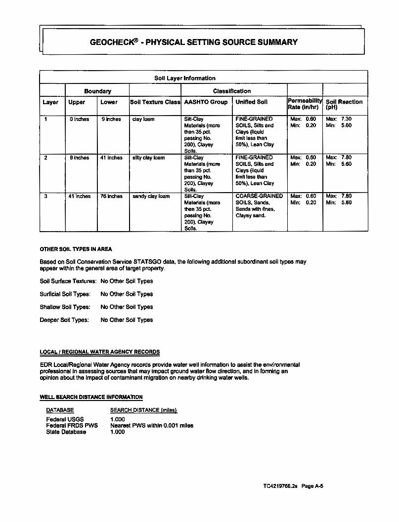
Soli Layer Information
Boundary Classification
Layer Upper Lower Soli Texture Class AASHTO Group Unified Soli Permeablll_ty Rate (in/hr)
1 Ofnches 9inches clay loam Slit-Clay FINE-GRAINED Max: 0.60 Materials (more SOILS, Sihs and Mfn: 0.20 than 35pet. Clays (liquid passing No. limit less than 200), Clayey 50%), Lean Clay Soils.
2 91nches 41 inches silty clay loam Slit-Clay FINE-GRAINED Max: 0.60 Materials (more SOILS, Slits and Mfn: 0.20 than 35 pet. Clays (liquid passing No. limit less than 200), Clayey 50%), Lean Clay Soils.
3 41 Inches 761nches sandy clay loam Silt-Clay COARSE-GRAINED Max: 0.60 Materials (more SOILS, Sands, Min: 0.20 than 35 pet. Sands with fines, passing No. Clayey sand. 200), Clayey Soils.
OTHER SOIL TYPES IN AREA
Based on Soli Conservation Service STATSGO data, the following additional subordlnant soil types may appear within the general area of target property.
Soli Surface Textures: No Other Soil Types
Surficial Soli Types: No Other Soil Types
Shallow Soli Types: No Other Soli Types
Deeper Soil Types: No Other Soil Types
LOCAL I REGIONAL WATER AGENCY RECORDS
EDR Local/Regional Water Agency records provide water well information to assist the environmental professional in assessing sources that may impact ground water flow direction, and In forming an opinion about the impact of contaminant migration on nearby drinking water wells.
WELL SEARCH DISTANCE INFORMAnON
DATABASE
Federal USGS Federal FRDS PWS State Database
SEARCH DISTANCE (miles)
1.000 Nearest PWS within 0.001 miles 1.000
TC4219766.2s Page A-5
Soli Reaction (pH)
Max: 7.30 Min: 5.60
Max: 7.80 Min: 5.60
Max: 7.80 Min: 5.60

GEOCHEC~ ·PHYSICAL SETTING SOURCE SUMMARY
FEDERAL USGS WELL INFORMATION
MAPID
2 4
WELLID
USGS40000182555 USGS40000182562
FEDERAL FRDS PUBUC WATER SUPPLY SYSTEM INFORMATION
MAPID WELLID
No PWS System Found
Note: PWS System location Is not always the same as well location.
STATE DATABASE WELL INFORMATION
MAPID
1 3
WELLID
7655 6835
LOCATION FROMTP
1/2 - 1 Mile South 112-1 Mile SE
LOCATION FROMTP
LOCATION FROMTP
1/4 - 1/2 Mile South 1/2-1 MileSW
TC4219766.2s Page A-6

PHYSICAL SETTING SOURCE MAP- 4219766.2s
/I/ County Boundary
Major Roads
Contour Llnes
Earthquake Fault Unes
Airport:;
@ Earthquake epicenter, Richter 5 or greater
® WaterWells
® Public Water Supply Wells
e Cluster of Multiple Icons
SITE NAME: Vacant Land ADDRESS: Araujo Street
San Jose CA 95131 LAT/LONG: 37.3793/121.8815
0 112
Groundwater Flow Direction
(c 1) Indeterminate Groundwater Flow at Location
(C v) Groundwater Flow Varies at Location
<ElD Clocest Hydrogeological Data
e Oil, gas or related wells
1 LIUu
CUENT: Farshad Vakili, P.E., Phase 1 Assessment CONTACT: Farshad Vakili, P.E. INQUIRY #: 4219766.2s DATE: February 27, 2015 12:48 pm
CoD)'fll hl o 2015 EDR. In: 0 2010 Tolo Allu Rol 0712009

GEOCHECK®- PHYSICAL SETTING SOURCE MAP FINDINGS
MapiD Direction Distance Elevation 1 South 114 • 112 Mila Higher
Water System Information:
2
Prime Station Code: 07SI01E-08Q01 M User ID: FRDS Number: 4310028001 County: District Number: 05 Station Type: Water Type: Well/Groundwater Well Status: Source Latllong: 372230.01215250.0 Precision: Source Name: MAIN CAMPUS WEll 01 -DESTROYED System Number: 4310028 System Name: San Jose State University Organization That Operates System:
One Washington Square San Jose, CA 95192
Pop Served: 30000 Connections: Area Sarvsd: Not Reported
South 112-1 Mile Lower
Org. Identifier: USGS-CA Formal name: USGS Celifomla Water Science Center Monloc Identifier: USGs-372207121525701 Monloc name: 006S001E32G001M Monloc type: Well Monloc desc: Not Reported Hue code: Not Reported Dmlnagearea value: Dmlnagearea Units: Not Reported Contrlb dmlnagearea: Contrlb dralnagearea units: Not Reported Latitude: Longitude: -121.8835833 Sourcemap scale:
Database
CAWELLS
HEN Santa Clara WELUAMBNTIMUNIINTAKE Destroyed 1,000 Feet (10 Seconds)
1000
FED USGS
Horlz AJ;c measure: .5 Horlz AJ;c measure units:
Not Reported Not Reported 37.3664444 24000 seconds
Horlz Collection method: Global positioning system (GPS), uncorrected Horiz coord refsys: NAD83 Vert measure val: Vert measure units: feet Vertacc measure val: Vert acaneasure units: feet Vertcollectlon method: Interpolated from topographic map Vert coord refsys: NGVD29 Countrycode: Aqulfername: Cellfomla Coastal Basin aquifers Formation type: Not Reported Aquifer type: Not Reported Construction date: 19600901 Welldepth units: ft Wellholedepth units: ft
Ground-water levels, Number of Measurements: 0
3 sw 112·1 Mile Lower
WeUdepth: Wellholedepth:
65 2.5
us
800 800
CAWELLS
EDR ID Number
7655
U~000182555
6835
TC4219766.2s Page A-8

GEOCHECK®- PHYSICAL SETTING SOURCE MAP FINDINGS
Water System Information: Prime Station Code: 06S/01 E-32E04 M FRDS Number: 4300820001 District Number: 05 Water Type: Well/Groundwater Source Latllong: 372204.01215325.0 Source Name: WELL 01 System Number: 4300820 System Name: Trailer Tel RV Part< Organization That Operates System:
Pop Served: Area Served: Semple Collected: Chemical:
Sample Collected: Chemical:
Sample Collected: Chemical:
Sample Collected: Chemical:
Sample Collected: Chemical:
Sample CoRseted: Chemical:
Sample Collected: Chemical:
Sample Collected: Chemical:
Sample Collected: Chemical:
Sample Collected: Chemical:
4 SE 112 ·1 Mile Higher
1212 Oakland Road San Jose, CA 95112 250 Not Reported 05-MAY-82 SPECIFIC CONDUCTANCE
05-MAY-82 PH, LABORATORY
05-MAY-82 BICARBONATE ALKALINITY
05-MAY-82 HARDNESS (TOTAL) AS CAC03
05-MAY-82 CALCIUM
05-MAY-82 MAGNESIUM
05-MAY-82 SODIUM
05-MAY-82 CHLORIDE
05-MAY-82 FOAMING AGENTS (MBAS)
05-MAY-82 TOTAL DISSOLVED SOLIDS
Org. ldenllfter: USGS-CA
UseriD: County: Station Type: Well Status: Precision:
Connections:
Findings:
Findings:
Findings:
Findings:
Findings:
Findings:
Andings:
Findings:
Findings:
Findings:
Formal name: USGS Csllfomla Water Science Center Monloc ldentlfler: USGS-372210121520501 Monloc name: 006S001E33F006M Monloc type: Well Monloc desc: Not Reported Hue code: Not Reported Dralnagearea value: Dralnagearea Unlls: Not Reported Contrlb dralnagearea: Con1rlb dralnagearea units: Not Reported Latitude: Longitude: ·121.86825 Sourcemap scale:
HEN Santa Clara WELUAMBNTIMUNIINTAKE Active Raw 100 Feet (one Second)
170
1340. us
8.1
432. MGIL
677. MGIL.
135. MGIL.
83. MGIL
62. MGIL.
84. MGIL
5.8-(102 MGIL.
931. MG/L
FED USGS
Not Reported Not Reported 37.3696667 24000
USGS40000182562
TC4219766.2s Page A-9

GEOCHECK®- PHYSICAL SETTING SOURCE MAP FINDINGS
Horiz Ace measure: Horiz Collection method: Horiz coord refsys: Vert measure units: Vert acaneasure units: Vertcollectlon melhod: Vert coord refsys: Aqulfemame: Fonnatlon type: Aquifer type: Construction date: Welldepth units: Wellholedepth units:
.5 Horiz Acc measure units: Global positioning system (GPS), unoorreded NAD83 Vert measure val: feet Vertacc measure val: feet Interpolated from topographic map NGVD29 Countrycode: California Coastal Basin aquifers Not Reported Not Reported 19630814 Welldepth: ft Wellholedepth: ft
Ground-water levels, Number of Measurements: 0
seconds
95 5
us
612 680
TC4219766.2s Page A-10

GEOCHECK®- PHYSICAL SETTING SOURCE MAP FINDINGS RADON
AREA RADON INFORMATION
State Database: CA Radon
Radon Test Results
Zlpcode NumTests >4 pCi/L
95131 22 0
Federal EPA Radon Zone for SANTA CLARA County: 2
Note: Zone 1 Indoor average level > 4 pCi/L. : Zone 2 Indoor average level >= 2 pCIIl and <= 4 pCill. : Zone 3 Indoor average level < 2 pCI/L.
Federal Area Radon Information for SANTA CLARA COUNTY, CA
Number of sites tested: 70
Area
Living Area -1st Floor Uvlng Area - 2nd Floor Basement
Average Activity
1.363 pCIJL 2.100 pCI/L 2.300 pCIJL
o/o <4 pCI/L
91% 100% 100%
%4-20pCIJL
9% 0% 0%
% >20 pCIJL
0% 0% 0%
TC4219766.2s Page A-11

PHYSICAL SETTING SOURCE RECORDS SEARCHED
TOPOGRAPHIC INFORMATION
USGS 7.5' Digital Elevation Model (OEM) Source: United States Geologic Survey EDR acquired the USGS 7.5' Digital Elevation Model in 2002 and updated it In 2006. The 7.5 minute OEM corresponds to the USGS 1 :24,000- and 1 :25,00Q..scale topographic quadrangle maps. The OEM provides elevation data with consistent elevation units and projection.
Scanned Digital USGS 7.5' Topographic Map (DRG) Source: United States Geologic Survey A digital raster graphic (DRG) is a scanned Image of a U.S. Geological Survey topographic map. The map Images are made by scanning published paper maps on high-resolution scanners. The raster Image is georaferencad and fit to the Universal Transverse Mercator (UTM) projection.
HYDROLOGIC INFORMATION
Flood Zone Data: This data, available in salad counties across the country, was obtained by EDR in 2003 & 2011 from the Federal Emergency Management Agency (FEMA). Data depicts 100-year and 500-year flood zones as defined by FEMA.
NWI: National WeUands Inventory. This data, avaHable in seled counties across the country, was obtained by EDR In 2002, 2005 and 2010 from the U.S. Fish and Wildlife Service.
HYDROGEOLOGIC INFORMATION
AQUIFLOWR Information System Source: EDR proprietary database of groundwater flow Information EDR has developed the AQUIFLOW Information System (AIS) to provide data on the general direction of groundwater
flow at specific points. EDR has reviewed reports submitted to regulatory authorities at select sites and has extradad the data of the report, hydrogeologlcally determined groundwater flow direction and depth to water table information.
GEOLOGIC INFORMATION
Geologic Aga and Rock Stratigraphic Unit Source: P.G. Schruban, R.E. Arndt and W.J. Baw!ec, Geology of the Contanninous U.S. at 1:2,500,000 Scale ·A digital representalion of the 1974 P.B. King and H.M. Belkman Map, USGS Digital Data Series DDS -11 (1994).
STATSGO: State Soil Geographic Database Source: Department of AgrtcuHure, Natural Resources Conservalion Services The U.S. Department of Agriculture's (USDA) Natural Resources Conservation Service (NRCS) leads the national Conservation Soil Survey (NCSS) and Is responsible for collecting, storing, maintaining and distributing soli survey lnfotrnatlon for privately owned lands in the United States. A son map in a soil survey is a representalion of soD pattams In a landscape. Soil maps for STATSGO are complied by generallzing more detailed (SSURGO) soil survay maps.
SSURGO: Soil Survey Geographic Database Source: Department of Agriculture, Natural Resources Conservation Services (NRCS) Telephone: 800-672-5559 SSURGO Is the most detailed level of mapping done by the Natural Resources Conservation Services, mapping scales generally range rrom 1:12,000 to 1:63,360. Field mapping methods using national standards are used to construd the soli maps in the Soil Survey Geographic (SSURGO) database. SSURGO digitizing duplicates the original soil survey maps. This level of mapping is designed for use by landowners, townships and county natural resource planning and management.
TC4219768.2s Page PSGR-1

PHYSICAL SETTING SOURCE RECORDS SEARCHED
LOCAL I REGIONAL WATER AGENCY RECORDS
FEDERAL WATER WELLS
PWS: Publlc Water Systems Source: EPA/Office of Drinking Water Telephone: 202-564-3750 Public Water System data from the Federal Reporting Data System. A PWS Is any water system which provides water to at
least 25 people for at least 60 days annually. PWSs provide water from wells, rivers and other sources.
PWS ENF: Public Water Systems Violation and Enforcement Data Source: EPA/Office of Drinking Water Telephone: 202-564-3750 Violation and Enforcement data for Public Water Systems from the Safe Drinking Water Information System (SDWIS) after
August 1995. Prior to August 1995, the date came from the Federal Reporting Data System (FRDS).
USGS Water Wells: USGS National Water lnventmy System (NWIS) This database contains descriptive information on sites where the USGS collects or has collected data on surface water and/or groundwater. The groundwater data Includes Information on wells, springs, and other sources of groundwater.
OTHER STATE DATABASE INFORMATION
RADON
State Database: CA Radon Source: Department of Health Services Telephone: 916-324-2208 Radon Database for Califomla
Area Radon Information Source: USGS Telephone: 703-356-4020 The National Radon Database has been developed by the U.S. Environmental Protection Agency (USEPA) and Is a compilation of the EPA/State Residential Radon Survey and the National Residential Radon Survey. The study covers the years 1986- 1992. Where necessary data has been supplemented by Information collected at private sources such as universities and research Institutions.
EPA Radon Zones Source: EPA Telephone: 703-356-4020 Sections 307 & 309 of IRAA directed EPA to list and identify arees of U.S. with the potential for elevated Indoor radon levels.
OTHER
Airport Landing Facilities: Private and public use landing facilities Source: Federal Aviation Administration, 800-457-6656
Epicenters: World earthquake epicenters, Richter 5 or greater Source: Department of Commerce, National Oceanic and Atmospheric Administration
California Earthquake Fault Unes: The fault lines displayed on EDR's Topographic map are digitized quaternary fault lines, prepared in 1975 by the United State Geological Survey. Additional Information (also from 1975) regarding activity at specific fault lines comes from Califomla's Preliminary Fault Activity Map prepared by the California Division of Mines and Geology.
TC4219766.2s Page PSGR-2

PHYSICAL SETTING SOURCE RECORDS SEARCHED
STREET AND ADDRESS INFORMATION
@ 2010 Tele Atlas North America, Inc. All rights reserved. This material Is proprietary and the subjed of copyright protection and other lntelledual property rights owned by or licensed to Tela AUas North America, Inc. The use of this materiel is subjed to the tanns of a license agreement You will be held liable for any unauthorized copying or disclosure of this materiel.
TC4219766.2s Page PSGR-3

Phase I Environmental Site Assessment Report Vacant land at Araujo Street, San Jose, Santa Clara County, Callfomla March 2, 2015
ATTACHMENT 3 PHOTOGRAPHS

Phase I Environmental Site Assessment Report Vacant land at Araujo Street. San Jose, Santa Clara County, California March 2, 2015
NOTICE OF DEVELOPMENT PROPOSAL oti<ICodo -Dopo-
1 ,,
Photo 1: Looking at the City of San Jose Notice of Development
Photo 2: Looking northwest at the Subject Property

Phase I Environmental Site Assessment Report Vacant land at Araujo Street, San Jose, Santa Clara County, California March 2, 2015
Photo 3: Looking west at the Subject Property
Photo 4: Looking north at the side of the Subject Property

Phase I Environmental Site Assessment Report Vacant land at Araujo Street, San Jose, Santa Clara County, California March 2, 2015
Photo 5: Looking at San Jose Municipal Golf Course next to the property
Photo 6: Looking north at the Subject Property on Araujo Street

Phase I Environmental Site Assessment Report Vacant land at Araujo Street, San Jose, Santa Clara County, Callfomla March 2, 2015
ATTACHMENT 4 EDR RADIUS MAP REPORT

Vacant Land Araujo Street San Jose, CA 95131
I Inquiry Number: 4219766.2s February 27, 2015
• ~ t • ~ - •• 1._ : \.. ., .. .. • • • • • • • _;-:. .. ,.
• •- • '• .. ,·_.:_ '• · ..... : .. ..;:.._:. •. ~·.":"'-;• ."'";,.~·:....~·:.#::':..:..~-: ... _. __ :: .... ~ .., ! a •,' ·,. =', .. • • ... · ~ ..;',•,:.·,t· .... ,:,
t:'EDRe Environmental Data Resources Inc
6 Armslrong Road. 4111 floor Shotlon. Ci 06484 Toll Free. 800 352 0050 www edmol.com
r ORM·LBD.UEM

~L ________________ T_A_B_L_E_O_F_c_o_N_T_E_N_T_s ____________ ~'l SECTION PAGE
Executive Summary. ______________________________________________ - _-- _- _ _ ES1
Overview Map. __________________________________________________ - - - - - - - - 2
Detail Map. _ _ _ _ _ _ _ _ _ _ _ _ _ _ _ _ _ _ _ _ _ _ _ _ _ _ _ _ _ _ _ _ _ _ _ _ _ _ _ _ _ _ _ _ _ _ _ _ _ _ _ _ _ _ _ _ _ _ _ _ _ 3
Map Findings Summary. ___________________________________________ - - - - - - - . 4
Map Findings.__ _ _ _ _ _ _ _ _ _ _ _ _ _ _ _ _ _ _ _ _ _ _ _ _ _ _ _ _ _ _ _ _ _ _ _ _ _ _ _ _ _ _ _ _ _ _ _ _ _ _ _ _ _ _ _ _ _ 8
Orphan Summary. _______________________________________________________ . 395
Government Records Searched/Data Currency Tracking. _ _ _ _ _ _ _ _ _ _ _ _ _ _ _ _ _ _ _ _ _ _ _ _ _ GR-1
GEOCHECK ADDENDUM
Physical Setting Source Addendum _ _ _ _ _ _ _ _ _ _ _ _ _ _ _ _ _ _ _ _ _ _ _ _ _ _ _ _ _ _ _ _ _ _ _ _ _ _ _ _ _ A·1
Physical Setting Source Summary. __________________________________________ . A-2
Physical Setting Source Map. ______________________________________________ . A-7
Physical Setting Source Map Findings. _ _ _ _ _ _ _ _ _ _ _ _ _ _ _ _ _ _ _ _ _ _ _ _ _ _ _ _ _ _ _ _ _ _ _ _ _ _ _ A-8
Physical Setting Source Records Searched_ _ _ _ _ _ _ _ _ _ _ _ _ _ _ _ _ _ _ _ _ _ _ _ _ _ _ _ _ _ _ _ _ _ _ _ PSGR-1
Thank you for your business. Please contact EDR at 1-800-352.0050
with any questions or comments.
Disclaimer • Copyright and Trademark Notice
This Report contains certain information obtained from a variety of public and other sources reasonably available to Environmental Data Resources, Inc. It cannot be concluded from this Report that coverage information for the target and surrounding properties does not exist from other sources. NO WARRANTY EXPRESSED OR IMPLIED, IS MADE WHATSOEVER IN CONNECnON WITH THIS REPORT. ENVIRONMENTAL DATA RESOURCES, INC. SPECIFICALLY DISCLAIMS THE MAKING OF ANY SUCH WARRANnES, INCLUDING WITHOUT LIMIT AnON, MERCHANTABILITY OR FITNESS FOR A PARnCULAR USE OR PURPOSE. ALL RISK IS ASSUMED BY THE USER. IN NO EVENT SHALl. ENVIRONMENTAL DATA RESOURCES, INC. BE LIABLE TO ANYONE, WHETHER ARISING OUT OF ERRORS OR OMISSIONS, NEGLIGENCE, ACCIDENT OR ANY OTHER CAUSE, FOR ANY LOSS OF DAMAGE, INCLUDING, WITHOUT UMITAnON, SPECIAL, INCIDENTAL, CONSEQUENTIAL, OR EXEMPLARY DAMAGES. ANY LIABILITY ON THE PART OF ENVIRONMENTAL DATA RESOURCES, INC. IS STRICTLY LIMITED TO A REFUND OF THE AMOUNT PAID FOR THIS REPORT. Purchaser accepts this Report "AS IS". Any analyses, estimates, ratings, environmental risk levels or risk codes provided in this Report are provided for illustrative purposes only, and are not intended to provide, nor should they be interpreted as providing any facts regarding, or prediction or forecast of, any environmental risk for any property. Only a Phase I Environmental Site Assessment performed by an environmental professional can provide Information regarding the environmental risk for any property. Additionally, the information provided in this Report is not to be construed as legal advice.
Copyright 2015 by Environmental Data Resources, Inc. All rights reserved. Reproduction in any media or format, in whole or in part, of any report or map of Environmental Data Resources, Inc., or its afllliates, is prohibited without prior written permission.
EDR and its logos (including Sanborn and Sanborn Map) are trademarks of Environmental Data Resources, Inc. or its affiliates. All other trademarks used herein are the orooertv of their resoectlve owners.
TC4219766.2s Page 1

~~---------------E_X_E_c_u_T_IV_E_s_u_M_M_A_R_v ______________ ~'l A search of available environmental records was conducted by Environmental Data Resources, Inc (EDR). The report was designed to assist parties seeking to meet the search requirements of EPA's Standards and Practices for All Appropriate Inquiries (40 CFR Part 312), the ASTM Standard Practice for Environmental Site Assessments (E 1527-13) or custom requirements developed for the evaluation of environmental risk associated with a parcel of real estate.
TARGET PROPERTY INFORMATION
ADDRESS
ARAUJO STREET SANTA CLARA County, CA 95131
COORDINATES
latitude (North): 37.3793000- 37" 22' 45.48" Longitude (West): 121.8815000- 121" 52' 53.40" Universal Tranverse Mercator: Zone 10 UTM X (Meters): 599027.3 UTM Y (Meters): 4137333.5 Elevation: n ft. above sea level
USGS TOPOGRAPHIC MAP ASSOCIATED WITH TARGET PROPERTY
Target Property Map: Most Recent Revision:
37121-08 MILPITAS, CA 1980
East Map: Most Recent Revision:
37121-07 CALAVERAS RESERVOIR, CA 1980
Southeast Map: Most Recent Revision:
South Map: Most Recent Revision:
AERIAL PHOTOGRAPHY IN THIS REPORT
Portions of Photo from: Source:
TARGET PROPERTY SEARCH RESULTS
37121-C7 SAN JOSE EAST, CA 1980
37121-C8 SAN JOSE WEST, CA 1980
20120520 USDA
The target property was not listed In any of the databases searched by EDR.
TC4219766.2s EXECUTIVE SUMMARY 1

~L_ ______________ E_x_Ec_u_r_lv_E_s_u_M_M_A_R_v ______________ ~'l DATABASES WITH NO MAPPED SITES
No mapped sites were found In EDR's search of available (Dreasonably ascertainable ") government records either on the target property or within the search radius around the target property for the following databases:
STANDARDE~RONMENTALRECORDS
Federal NPL site list NPL. ________________________ National Priority List Proposed NPL _______________ Proposed National Priority List Sites NPL LIENS. __________________ Federal Superfund Liens
Federal Dellsted NPL site list De listed NPL _ _ _ _ _ _ _ _ _ _ _ _ _ _ _ _ National Priority List Deletions
Federal CERCUS list
CERCUS. ____________________ Comprehensive Environmental Response, Compensation, and Liability Information System FEDERAL FACILITY. ________ . Federal Facility Site Information listing
Federal RCRA generators list
RCRA-CESQG _______________ RCRA- Conditionally Exempt Small Quantity Generator
Federal Institutional controls I engineering controls registries
LUCIS. _________________ •••••• Land Use Control Information System
Federal ERNS list
ERNS. _ .•.••••••••••...•••• _. Emergency Response Notification System
State and triballandRII and/or solid waste disposal site lists
CA SWF/LF ••••••.••••••••. _ •. Solid Waste Information System
State and tribal leaking storage tank lists
INDIAN LUST ••••••..•••••.••. Leaking Underground Storage Tanks on Indian Land
State and tribal registered storage tank lists
CA UST •••.•••••••••••.•••••• Active UST Facilities CAAST •• -----·----------···- Aboveground Petroleum Storage Tank Facilities INDIAN UST •••••••••••••••••. Underground Storage Tanks on Indian Land FEMA UST •••••.••• __________ Underground Storage Tank Listing
State and tribal voluntary cleanup sites
INDIAN VCP. _ ••••••..•••• _. _. Voluntary Cleanup Priority Listing
TC4219766.2& EXECUTIVE SUMMARY 2
~L _______________ EX __ E_c_u_T_IV_E_s_u_M_M_A_R_v ______________ ~'l ADDmONAL ENVIRONMENTAL RECORDS
Local Brownneld lists
US BROWNFIELDS •••••••.•• A Listing of Brownfields Sites
Local Lists of Landfill I Solid Waste Disposal Sites
ODL •••••••••••.•••.••••••••. Open Dump Inventory DEBRIS REGION 9 ••••••••••. Torres Martinez Reservation Illegal Dump Site Locations CA SWRCY •••••••••..••••.•• Recycler Database CA HAULERS.. . • • . . • • • • • • • • • Registered Waste Tire Haulers Listing INDIAN ODL •••••••••••.•••• Report on the Status of Open Dumps on Indian Lands CA WMUDS/SWAT .•••..••••• Waste Management Unit Database
Local Lists of Hazardous waste I Contaminated Sites
US COL ••••••••••••••••••••• Clandestine Drug Labs CA HIST Cal-Sites ..•••••••••• Historical Calsites Database CA SCH •••.••••••.•••.••••••• School Property Evaluation Program CA Toxic Pits ••••••..•••.••••• Toxic Pits Cleanup Act Sites CA COL •.•••••••••.••••••••• Clandestine Drug Labs US HIST COL. •.•.••••••••••. National Clandestine Laboratory Register
Local Lists of Registered Storage Tanks
CA FlO UST •••••.•••••••.•••• Facility Inventory Database
Local Land Records
LIENS 2. ..•.•...............• CERCLA Lien Information CA LIENS.................... Environmental Liens Listing
Records of Emergency Release Reports
HMIRS....................... Hazardous Materials Information Reporting System CA LOS •••••••.......••...•.. Land Disposal Sites Listing CA MCS ••••••.••••••••••••••• Military Cleanup Sites Listing CA SPILLS 90 •••..•.••••••..• SPILLS 90 data from First Search
Other Ascertainable Records
RCRA NonGen I NLR •...••.. RCRA - Non Generators I No Longer Regulated DOT OPS •••••••••••••••••••• Incident and Accident Data DOD ••••••••.••••••••••.•••••. Department of Defense Sites FUDS •••••••.••.••••.••..•••• Formerly Used Defense Sites CONSENT .••••.•••••••••••••. Superfund (CERCLA) Consent Decrees UMTRA ••••••••••••.•.•••••.. Uranium Mill Tailings Sites US MINES ••••••••••..•••••... Mines Master Index File TSCA. •.•••••••••••••••••••••. Toxic Substances Control Act FTTS ••••..••••••••.•••••••••• FIFRA/ TSCA Tracking System - FIFRA (Federal Insecticide, Fungicide, & Rodenticide
Act)ITSCA (Toxic Substances Control Act) HIST FTTS ••••..•...••..•••.• FIFRAITSCA Tracking System Administrative Case Listing
TC4219766.2s EXECUTIVE SUMMARY 3
~L _______________ E_X_E_c_u_T_IV_E_s_u_M_M_A_R_v ______________ ~·~ SSTS _________________________ Section 7 Tracking Systems ICIS. _________________________ Integrated Compliance Information System PADS ••••.••••••••••••••••.••. PCB Activity Database System ML TS. _______________________ . Material Licensing Tracking System RADINFO. _ _ _ _ _ _ _ _ _ _ _ _ _ _ _ _ _ _ _ Radiation Information Database RAA TS. ______________________ RCRA Administrative Action Tracking System
RMP·------------------------· Risk Management Plans CA UIC •••••••••••••.•.••••••• UIC Listing CA Cortese ___________________ "Cortese• Hazardous Waste & Substances Sites List CA Notify 65. _________________ Proposition 65 Records CA DRYCLEANERS .••..•••.. Cleaner Facilities CA WIP. _ •• __________________ . Well Investigation Program Case List INDIAN RESERV ••••••.•.•••• Indian Reservations SCRD DRYCLEANERS. _____ . State Coalition for Remediation of Drycleaners Listing CA PROC. _______________ •••• Certified Processors Database CA HWT. ____________________ . Registered Hazardous Waste Transporter Database US AIRS. ____________________ . Aerometric Information Retrieval System Facility Subsystem LEAD SMELTERS •••• _._ ••••• Lead Smelter Sites EPA WATCH LIST ••••••••.••. EPA WATCH LIST COAL ASH EPA.. __________ ._ Coal Combustion Residues Surface Impoundments List PCB TRANSFORMER. ..••••. PCB Transformer Registration Database COAL ASH DOE. ________ ••••. Steam-Electric Plant Operation Data
EDR HIGH RISK HISTORICAL RECORDS
EDR Exclusive Records EDR MGP. ________________ • __ EDR Proprietary Manufactured Gas Plants EDR US Hist Cleaners ________ EDR Exclusive Historic Dry Cleaners
EDR RECOVERED GOVERNMENT ARCHIVES
Exclusive Recovered Govt. Archives
CA RGA LF •••• _. ________ •..•. Recovered Government Archive Solid Waste Facilities List CA RGA LUST ••.•.• _____ ••• _. Recovered Government Archive Leaking Underground Storage Tank
SURROUNDING SITES: SEARCH RESULTS
Surrounding sites were Identified in the following databases.
Elevations have been determined from the USGS Digital Elevation Model and should be evaluated on a relative (not an absolute) basis. Relative elevation information between sites of close proximity should be field verified. Sites with an elevation equal to or higher than the target property have been differentiated below from sites with an elevation lower than the target property. Page numbers and map identification numbers refer to the EDR Radius Map report where detailed data on Individual sites can be reviewed.
Sites listed In bold Italics are In multiple databases.
Unmappable (orphan) sites are not considered in the foregoing analysis.
TC4219766.2s EXECUTIVE SUMMARY 4

~L _______________ EX __ E_c_u_T_IV_E_s_u_M_M_A_R_v ______________ ~·~ STANDARDE~RONMENTALRECORDS
Federal RCRA CORRACTS facilities list
CORRACTS: CORRACTS is a list of handlers with RCRA Corrective Action Activity. This report shows which nationally-defined corrective action core events have occurred for every handler that has had corrective action activity.
A review of the CORRACTS list, as provided by EDR. and dated 12/09/2014 has revealed that there is 1 CORRACTS site within approximately 1 mile of the target property.
Lower Elevation
CLEANHARSORSSANJOSELLC
Address Direction I Distance Map ID Page
1021 BERRVESSA ROAD S 112- 1 (0.766 mi.) 023 59
State- and tribal- equivalent NPL
CA RESPONSE: Identifies confirmed release sites where DTSC is involved In remediation, either in a lead or oversight capacity. These confirmed release sites are generally high-priority and high potential risk.
A review of the CA RESPONSE list, as provided by EDR, and dated 11/03/2014 has revealed that there is 1 CA RESPONSE site within approximately 1 mile of the target property.
Lower Elevation Address Direction I Distance Map ID Page
RJNGWOODIMCKA Y SITE RINGWOOD AVE & MCKAY DNW 112 • 1 (0.892 mi.} 28 381
State- and tribal- equivalent CERCUS
CA ENVIROSTOR: The Department of Toxic Substances Control's (OTSC's) Site Mitigation and Brownfields Reuse Program's (SMBRP's) EnvlroStor database ldentlfes sites that have known contamination or sites for which there may be reasons to Investigate further. The database includes the following site types: Federal Superfund sites (National Priorities List (NPL)); State Response, including Military Facilities and State Superfund; Voluntary Cleanup; and School sites. EnviroStor provides similar Information to the information that was available In CaiSites, and provides additional site Information, Including, but not limited to, Identification of formerly-contaminated properties that have been released for reuse, properties where environmental deed restrictions have been recorded to prevent inappropriate land uses, and risk characterization Information that Is used to assess potential impacts to public health and the environment at contaminated sites.
A review of theCA ENVIROSTOR list, as provided by EDR. and dated 11/03/2014 has revealed that there are 17 CA ENVIROSTOR sites within approximately 1 mile of the target property.
Equal/Higher Elevation Address Direction I Distance MapiD
KOMAG, INC. tl9 1705 AUTOMA noN PARKWAW 112 • 1 (0.584 mi.} 19 Status: Inactive - Needs Evaluation
WDMEDIALLC 1710 AUTOMA noN PY N 112- 1 (0.741 mi.} 21 Status: Inactive - Needs Evaluation
ELCON PRECISION LLC 1009 nMOTHY DR s 112 - 1 (0.848 mi.) 27 Status: Active
OCULAR LABS 923 BERRVESSA RD ssw 112- 1 (0.900 mi.) 31 Status: Inactive - Needs Evaluation
Page
46
54
356
387
TC4219766.2s EXECUTIVE SUMMARY 5

~ I
EXECUTIVE SUMMARY
Equal/Higher Elevation Address Direction I Distance MapiD Page
CHERRY ACRES PARTNERSHIP 1671MABURY SE 112 • 1 (0.935 mi.) 32 388 Status: No Further Action
ADAPTIVE CIRCUITS, DIV OF VIKO 1565-A MABURY ROAD SSE 1/2 ·1 (0.937 mi.) 33 391 Status: Inactive • Needs Evaluation
CONTROL DATA CORPORA nON 987 MASURY RD S 112 • 1 (0.996 mi.) 34 392 Status: Inactive - Needs Evaluation
Lower Elevation Address Direction I Distance MapiD Page
MURPHY/LUNDY DEVELOPMENT MURPHY & LUNDY AVES. (N NNW 1/2 -1 (0.553 mi.) C17 41 Status: Refer: Other Agency
YOUNG FAMILY NURSERY 1703 LUNDY AVENUE NNW 112 • 1 (0.583 mi.) C18 42 Status: Inactive • Needs Evaluation
ABOVENET COMMUNICAnONS 1735 LUNDY AVENUE NNW 112 • 1 (0.6fU mi.) 20 48 Status: Inactive - Needs Evaluation
QUANTUM CLEAN 1712 RINGWOOD AVE. NW 112 • 1 (0. 760 mi.) 22 56 Status: Inactive • Needs Evaluation
CLEAN HARBORS SAN JOSE LLC 1021 BERRYESSA ROAD S 112 • 1 (0.766 mi.) D23 59 Status: Refer: RWQCB
MARKOVITS & FOX 1633 OLD OAKLAND RD W 112 • 1 (0.806 mi.) 25 325 Status: Certified
BROKAW ROAD SITE 1040, 1060, AND 1080 EA WNW 112 • 1 (0.841 mi.) 26 342 Status: Certified I Operation & Malntanance
RINGWOODIMCKA Y SITE RINGWOOD AVE. & MCKAY D NW 112 • 1 (0.892 mi.) 28 381 Status: No Further Action
PHIUIPS SEMICONDUCTORS 1101 & 1109 MCKAY DRIVE NW 1/2 • 1 (0.895 mi.) 29 384 Status: Inactive • Needs Evaluation
TEL TEC INC (DBA GORILLA CIRCUI 1509 BERGER DR WSW 112 • 1 (0.898 mi.) 30 385 Status: Inactive • Needs Evaluation
State and tribal leaking storage tank lists
CA LUST: The Leaking Underground Storage Tank Incident Reports contain an Inventory of reported leaking underground storage tank incidents. The data come from the State Water Resources Control Board Leaking Underground Storage Tank Information System.
A review of theCA LUST list, as provided by EDR, and dated 01120/2015 has revealed that there are 11 CA LUST sites within approximately 0.5 miles of the target property.
Equal/Higher Elevation Address Direction I Distance MapiD
CHAN NURSERY 1260 TOWNSEND PARK CIR N 118 • 114 (0.178 mi.) 3 Status: Completed - Case Closed
K. TANAKA NURSERY 1472 LUNDY AVE NNW 114 • 112 (0.309 mi.) 7 Status: Completed - case Closed
NORTH VILLAGE PHASE I 1590 BERRYESSA ROAD SSE 114 • 112 (0.343 mi.) 8 Status: Completed - Case Closed
FACCHINO FREIGHT LINES 1655 BERRYESSA Status: Completed • case Closed
SSE 114 • 112 (0.445 mi.) 10
Page
9
12
14
21
TC4219768.2s EXECUTIVE SUMMARY 6
I

~ I
EXECUTIVE SUMMARY
EquaUHigher Elevation Address Direction I Distance MapiD Page
SHELL SERVICE STAnON 1705 8ERRYESSA SE 114 • 112 (0.469 mi.) 811 Status: Completed - Case Closed
SHELL 170S 8ERRYESSA RD SE 114 • 112 (0.469 mi.) 812 SHELL OIL COMPANY 170S 8ERRYESSA RD SE 114 • 112 (0.469 mi.) 813 8CAUTOCARE 171S 8ERRYESSA RD SE 114 • 112 (0.471 mi.) 814
Status: Completed • Case Closed
8ERRYESSA CHEVRON 171S 8ERRYESSA RD SE 114 • 112 (0.471 mi.) 81S
Lower Elevation Address Direction I Distance MapiD
CHAN NURSERY 1250 TOWNSEND PARK CIR WSW 118 • 114 (0.221 mi.) AS MIKE RAWITER GOLF SHOP 1560 OLD OAKLAND RD W 114 • 112 (0.483 mi.) 16
CA SLIC: SLIC Region comes from the California Regional Water Quality Control Board.
A review of theCA SLIC list, as provided by EDR, and dated 01120/2015 has revealed that there is 1 CA SLIC site within approximately 0.5 miles of the target property.
24
31 32 32
38
Page
11 40
EquaUHigher Elevation
WESTERN PACIFIC RAILROAD Facility Status: Open - Inactive
Address Direction I Distance Map ID Page
900 EAST WILLIAMS N 1/4 - 1/2 (0.399 mi.) 9 20
CA HIST LUST: A listing of open and closed leaking underground storage tanks. This listing Is no longer updated by the county. Leaking underground storage tanks are now handled by the Department of Environmental Health.
A review of the CA HIST LUST list, as provided by EDR, and dated 03129/2005 has revealed that there are 8 CA HIST LUST sites within approximately 0.5 miles of the target property.
EquaUHigher Elevation Address Direction I Distance MapiD Page
K. TANAKA NURSERY 1472 LUNDY AVE NNW 114 • 112 (0.309 mi.) 7 12 NORTH VILLAGE PHASE I 1590 8ERRYESSA ROAD SSE 114 - 112 (0.343 mi.) 8 14 FACCHINO FREIGHT UNES 1655 8ERRYESSA SSE 114 • 112 (0.445 mi.) 10 21 SHELL 1705 8ERRYESSA RD SE 1/4 - 112 (0-469 mi.) 812 31 SHELL OIL COMPANY 1706 8ERRYESSA RD SE 114 • 112 (0.469 mi.) 813 32 8ERRYESSA CHEVRON 171S 8ERRYESSA RD SE 114 • 112 (0.471 mi.) 81S 38
Lower Elevation Address Direction I Distance MapiD Page
CHAN NURSERY 1250 TOWNSEND PARK CIR WSW 118- 114 (0.221 mi.) AS 11 MIKE RAWITI:R GOLF SHOP 1S60 OLD OAKLAND RD W 114 • 112 (0.483 mi.) 16 40
ADDmONAL ENVIRONMENTAL RECORDS
Local Lists of Registered Storage Tanks
CA HIST UST: Historical UST Registered Database.
A review of the CA HIST UST list. as provided by EDR, and dated 10/15/1990 has revealed that there
TC4219766.2s EXECUTIVE SUMMARY 7
I

~L----------------EX_E_c_u_T_IV_E __ s_u_M_M_A_R_v ______________ ~·~ are 3 CA HIST UST sites within approximately 0.25 miles of the target property.
EquaUHigher Elevation
YAMADA BROS
Address Direction I Distance Map ID Page
CHAN NURSERY JOHN LUCCHETI
1449 LUNDY AVE NNE 0- 1/8 (0.109 mi.) 1 1250 TOWNSEND PARK CIR N 1/B- 114 (0.178 mi.} 3 1280 LUNDY AVE ESE 1/8-1/4 (0.208 mi.) 4
8 9 10
CA SWEEPS UST: Statewide Environmental Evaluation and Planning System. This underground storage tank listing was updated and maintained by a company contacted by the SWRCB in the early 1990's. The listing is no longer updated or maintained. The local agency Is the contact for more information on a site on the SWEEPS list.
A review of the CA SWEEPS UST list, as provided by EDR, and dated 06/01/1994 has revealed that there is 1 CA SWEEPS UST site within approximately 0.25 miles of the target property.
Lower Elevation Address Direction I Distance Map ID Page
T S CHAN NURSERY 1250 TOWNSEND PARK CIRC WSW 1/8- 1/4 (0.221 mi.) A6
Other Ascertainable Recorrls
ROD: Record of Decision. ROD documents mandate a permanent remedy at an NPL (Superfund) site containing technical and health information to aid the cleanup.
A review of the ROD list, as provided by EDR, and dated 11/25/2013 has revealed that there is 1 ROD site within approximately 1 mile of the target property.
11
Lower Elevation Address Direction I Distance Map ID Page
CLEAN HARBORS SAN JOSE LLC 1021 BERRYESSA ROAD S 112-1 (0.766 mi.) D23 59
CA BOND EXP. PLAN: Department of Health Services developed a site-specific expenditure plan as the basis for an appropriation of Hazardous Substance Cleanup Bond Act funds. It Is not updated.
A review of theCA BOND EXP. PLAN list, as provided by EDR, and dated 01/0111989 has revealed that there is 1 CA BOND EXP. PLAN site within approximately 1 mile of the target property.
Lower Elevation Address Direction I Distance Map ID Page
CLEAN HARBORS SAN JOSE., LLC 1021 BERRYESSA ROAD s 112- 1 (0.766 mi.} D24 318
CA HIST CORTESE: The sites for the list are designated by the State Water Resource Control Board (LUST], the Integrated Waste Board [SWFILS], and the Department of Toxic Substances Control [CALSITES]. This listing is no longer updated by the state agency.
A review of the CA HIST CORTESE list, as provided by EDR, and dated 04/01/2001 has revealed that there are 6 CA HIST CORTESE sites within approximately 0.5 miles of the target property.
EquaUHigher Elevation
K. TANAKA NURSERY NORTH VILLAGE PHASE I FACCHINO FREIGHT UNES
Address Direction I Distance Map ID Page
1472 LUNDY AVE 1590 BERRYESSA ROAD 1855 BERRYESSA
NNW 114- 112 (0.309 mi.} 7 SSE 114 - 112 (0.343 mi.} 8 SSE 114 • 112 (0.446 mi.} 10
12 14 21
TC4219766.2s EXECUTIVE SUMMARY 8

~L _______________ EX __ E_c_u_T_IV_E_s_u_M_M_A_R_v ______________ ~·~ Equal/Higher Elevation
SHELL 8CAUTOCARE
Lower Elevation
CHAN NURSERY
Address
1705 8ERRYESSA RD 1715 8ERRYESSA RD
Address
Direction I Distance Map ID Page
SE 114-112 (0.469 mi.) 812 31 SE 1/4 • 112 (0.471 mi.) 814 32
Direction I Distance Map ID Page
1250 TOWNSEND PARK CIR WSW 118 ·114 (0.221 mi.) AS 11
CA HWP: Detailed Information on permitted hazardous waste facilities and corrective action (•cleanups•) tracked in EnviroStor.
A review of theCA HWP list, as provided by EDR, and dated 11/2412014 has revealed that there is 1 CA HWP site within approximately 1 mile of the target property.
Lower Elevation Address Direction I Distance Map ID Page
CLEAN HARBORS SAN JOSE LLC 1021 8ERRYESSA ROAD S 112 • 1 (0.766 mi.) 023 59
EDR HIGH RISK HISTORICAL RECORDS
EDR Exclusive Records
EDR US Hist Auto Stat: EDR has searched selected national collections of business directories and has collected listings of potential gas station/filling station/service station sites that were available to EDR researchers. EDR's review was limited to those categories of sources that might, in EDR's opinion, include gas station/filling station/service station establishments. The categories reviewed Included, but were not limited to gas, gas station, gasoline station, filling station, auto, automobile repair, auto service station, service station, etc. This database falls within a category of Information EDR classifies as "High Risk Historical Records", or HRHR. EDR's HRHR effort presents unique and sometimes proprietary data about past sites and operations that typically create environmental concerns, but may not show up in current government records searches.
A review of the EDR US Hist Auto Stat list, as provided by EDR, has revealed that there is 1 EDR US Hist Auto Stat site within approximately 0.25 miles of the target property.
Equal/Higher Elevation
Not reported
Address
1170 ROYAL CREST DR
Direction I Distance Map ID Page
SE 1/8- 1/4 (0.141 mi.) 2 8
TC4219766.2s EXECUTIVE SUMMARY 9

~~---------------E_x_E_c_u_r_lv_E_s_u_M_M_A_R_v ______________ ~·~ Due to poor or Inadequate address lnfonnaUon, the following sites were not mapped. Count: 2 records.
Site Name
S&R PRECISION COMPANY
SILVERADO CONDOMINIUMS
Databese(s)
CA LUST, CA SLIC, CA Notify 65, CAEMI CERC-NFRAP
TC4210766.2s EXECUTIVE SUMMARY 10

.. ... ...
(
N Target Property
•
;
D
Sitae nt olevationc higher than or equal to the target property
Sltec at elevations lower than the targe t property
Mnnutactured Gas Plants
Senclbve Receptors
Nntlonnl Prionty Ust Sites
Dept Dolence Sltes
SITE NAME: Vacant Land ADDRESS: Araujo Street
San Jose CA 95131 LA T/LONG: 37.3793/121.8815
DETAIL MAP - 4219766.25
D
1116
Indian Recervadons BIA
Oil & Gas pipelines from USGS
100·year llood zone
500-year flood zone
Nauonal Wedand Inventory
1/11
' ~
/
")o /".·.
1/4 uu ••
Areas ol Concern
This report Includes lnteracli'le Map Layers to display and/or hide map lntormalion. The legend Includes only those icons tor the default map view.
CLIENT: Farshad Vakili, P.E., Phase 1 Assessment CONTACT: Farshad Vakili, P.E. INQUIRY fl: 4219766.25 DATE: February 27, 20 IS 12:47 pm
CoDIO;hl o 201:) EOR.Inc r <1010 lolo 1-tiu Rot 0712009
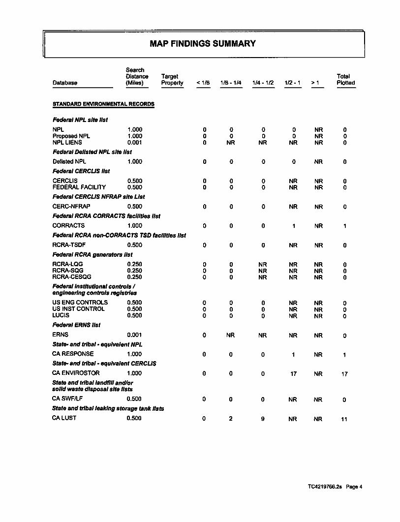
~ MAP FINDINGS SUMMARY
Search Distance Target Total
Database (Miles) Property < 1/8 1/8 -1/4 1/4-1/2 1/2- 1 >1 Plotted
STANDARDENWRONMENTALRECORDS
Federal NPL site list
NPL 1.000 0 0 0 0 NR 0 Proposed NPL 1.000 0 0 0 0 NR 0 NPL LIENS 0.001 0 NR NR NR NR 0
Federal Dellsted NPL site list
Delisted NPL 1.000 0 0 0 0 NR 0
Federal CERCUS list
CERCLIS 0.500 0 0 0 NR NR 0 FEDERAL FACILITY 0.500 0 0 0 NR NR 0
Federal CERCUS NFRAP site List
CERC-NFRAP 0.500 0 0 0 NR NR 0
Federal RCRA CORRACTS facilities list
CORRACTS 1.000 0 0 0 1 NR 1
Federal RCRA non-CORRACTS TSD facilities list
RCRA-TSDF 0.500 0 0 0 NR NR 0
Federal RCRA generators list
RCRA-LQG 0.250 0 0 NR NR NR 0 RCRA-SQG 0.250 0 0 NR NR NR 0 RCRA-CESQG 0.250 0 0 NR NR NR 0 Federal Institutional controls I engineering controls registries
US ENG CONTROLS 0.500 0 0 0 NR NR 0 US INST CONTROL 0.500 0 0 0 NR NR 0 LUCIS 0.500 0 0 0 NR NR 0 Federal ERNS list
ERNS 0.001 0 NR NR NR NR 0 State- and tribal· equivalent NPL
CARESPONSE 1.000 0 0 0 1 NR State- and tribal· equivalent CERCUS
CA ENVIROSTOR 1.000 0 0 0 17 NR 17 State and tribal landfill and/or solid waste disposal site lists
CASWFILF 0.500 0 0 0 NR NR 0 State and tribal leaking storage tank lists
CALUST 0.500 0 2 9 NR NR 11
TC4219766.2s Page 4

~ MAP FINDINGS SUMMARY
Search Distance Target Total
Database (Miles) Property < 1/8 1/8-1/4 1/4 -1/2 1/2-1 >1 Plotted
CASLIC 0.500 0 0 1 NR NR 1 CAHISTLUST 0.500 0 1 7 NR NR 8 INDIAN LUST 0.500 0 0 0 NR NR 0
State and tribal reglstemd storage tank lists
CAUST 0.250 0 0 NR NR NR 0 CAAST 0.250 0 0 NR NR NR 0 INDIAN UST 0.250 0 0 NR NR NR 0 FEMAUST 0.250 0 0 NR NR NR 0
State and tribal voluntary cleanup sites
CAVCP 0.500 0 0 0 NR NR 0 INDIANVCP 0.500 0 0 0 NR NR 0
ADDn10NALE~RONMENTALRECORDS
LocaiBrownReld lists
US BROWNFIELDS 0.500 0 0 0 NR NR 0
Local Lists of LandR/1 I Solid Waste Disposal Sites
ODI 0.500 0 0 0 NR NR 0 DEBRIS REGION 9 0.500 0 0 0 NR NR 0 CASWRCY 0.500 0 0 0 NR NR 0 CAHAULERS 0.001 0 NR NR NR NR 0 INDIANODI 0.500 0 0 0 NR NR 0 CA WMUDS/SWAT 0.500 0 0 0 NR NR 0
Local Lists of Hazardous waste I Contaminated Sites
USCDL 0.001 0 NR NR NR NR 0 CA HIST Cal-Sites 1.000 0 0 0 0 NR 0 CASCH 0.250 0 0 NR NR NR 0 CA Toxic Pits 1.000 0 0 0 0 NR 0 CACDL 0.001 0 NR NR NR NR 0 US HISTCDL 0.001 0 NR NR NR NR 0 Local Lists of Registered Storage Tanks
CAFIDUST 0.250 0 0 NR NR NR 0 CAHISTUST 0.250 1 2 NR NR NR 3 CA SWEEPS UST 0.250 0 1 NR NR NR 1 Local Land Records
LIENS2 0.001 0 NR NR NR NR 0 CALlENS 0.001 0 NR NR NR NR 0 CADEED 0.500 0 0 0 NR NR 0 Records of EmeiTlency Release Reports
HMIRS 0.001 0 NR NR NR NR 0 CACHMIRS 0.001 0 NR NR NR NR 0
TC4219766.2s Page 5

~ MAP FINDINGS SUMMARY
Search Distance Target Total
Database (Miles) Property < 1/8 1/8-1/4 1/4-1/2 1/2-1 >1 Plotted
CALDS 0.001 0 NR NR NR NR 0 CAMCS 0.001 0 NR NR NR NR 0 CASPILLS90 0.001 0 NR NR NR NR 0
Other Ascertainable Records
RCRA NonGen I NLR 0.250 0 0 NR NR NR 0 DOTOPS 0.001 0 NR NR NR NR 0 DOD 1.000 0 0 0 0 NR 0 FUDS 1.000 0 0 0 0 NR 0 CONSENT 1.000 0 0 0 0 NR 0 ROD 1.000 0 0 0 1 NR 1 UMTRA 0.500 0 0 0 NR NR 0 US MINES 0.250 0 0 NR NR NR 0 TRIS 0.001 0 NR NR NR NR 0 TSCA 0.001 0 NR NR NR NR 0 FTTS 0.001 0 NR NR NR NR 0 HISTFTTS 0.001 0 NR NR NR NR 0 SSTS 0.001 0 NR NR NR NR 0 I CIS 0.001 0 NR NR NR NR 0 PADS 0.001 0 NR NR NR NR 0 MLTS 0.001 0 NR NR NR NR 0 RADINFO 0.001 0 NR NR NR NR 0 FINDS 0.001 0 NR NR NR NR 0 RMTS 0.001 0 NR NR NR NR 0 RMP 0.001 0 NR NR NR NR 0 CA BOND EXP. PLAN 1.000 0 0 0 1 NR 1 CANPDES 0.001 0 NR NR NR NR 0 CAUIC 0.001 0 NR NR NR NR 0 CACortese 0.500 0 0 0 NR NR 0 CA HIST CORTESE 0.500 0 1 5 NR NR 6 CA CUPA Listings 0.250 0 0 NR NR NR 0 CA SAN JOSE HAZMAT 0.250 0 0 NR NR NR 0 WI MANIFEST 0.250 0 0 NR NR NR 0 NY MANIFEST 0.250 0 0 NR NR NR 0 CA Notlfy65 1.000 0 0 0 0 NR 0 CA DRYCLEANERS 0.250 0 0 NR NR NR 0 CAWIP 0.250 0 0 NR NR NR 0 CAENF 0.001 0 NR NR NR NR 0 CAHAZNET 0.001 0 NR NR NR NR 0 CAEMI 0.001 0 NR NR NR NR 0 INDIAN RESERV 1.000 0 0 0 0 NR 0 SCRD DRYCLEANERS 0.500 0 0 0 NR NR 0 CAMWMP 0.250 0 0 NR NR NR 0 CAWDS 0.001 0 NR NR NR NR 0 CA Financial Assurance 0.001 0 NR NR NR NR 0 CAPROC 0.500 0 0 0 NR NR 0 CAHWT 0.250 0 0 NR NR NR 0 CAHWP 1.000 0 0 0 1 NR 1 US AIRS 0.001 0 NR NR NR NR 0 LEAD SMELTERS 0.001 0 NR NR NR NR 0 USFINASSUR 0.001 0 NR NR NR NR 0
TC4219766.2s Page 6

~ MAP FINDINGS SUMMARY
Search Distance Target Total
Database (Miles) Property < 1/8 1/8- 1/4 1/4 -112 112-1 >1 Plotted
EPA WATCH LIST 0.001 0 NR NR NR NR 0 COALASHEPA 0.500 0 0 0 NR NR 0 PCB TRANSFORMER 0.001 0 NR NR NR NR 0 2020 COR ACTION 0.250 0 0 NR NR NR 0 PRP 0.001 0 NR NR NR NR 0 COALASHDOE 0.001 0 NR NR NR NR 0
EDR HIGH RISK HISTORICAL RECORDS
EDR Exclusive Records
EDRMGP 1.000 0 0 0 0 NR 0 EDR US Hist Auto Stat 0.250 0 1 NR NR NR 1 EDR US Hist Cleaners 0.250 0 0 NR NR NR 0
EDR RECOVERED GOVERNMENT ARCHIVES
Exclusive Recovered Govt. Archives
CARGALF 0.001 0 NR NR NR NR 0 CARGALUST 0.001 0 NR NR NR NR 0
NOTES:
TP = Target Property
NR = Not Requested at this Search Distance
Sites may be listed in more than one database
TC4219766.2s Page 7

Map ID Direction Distance Elevation Site
~L-----------M_A_P __ F_IN_D_IN_G_s ____________ ~·~
1 NNE < 1/8 0.109 mi. 578ft.
Relative: Higher
Actual: 83ft.
2 SE 1/8-1/4 0.141 mi. 747ft ..
Relative: Higher
Actual: 82ft.
YAMADA BROS 1449 LUNDY AVE SAN JOSE, CA 95131
HISTUST: Region: Facility ID: Facility Type: Other Type: Contact Name: Telephone: Owner Name: Owner Address: Owner City,St,Zip: Total Tanks:
Tank Num: Container Num: Year Installed: Tank Capacity: Tank Used for. Type of Fuel: Container Construction Thickness: leak Detection:
Tank Num: Container Num: Year lnstali€d: Tank Capacity: Tank Used for: Type of Fuel: C<>ntalner Construction Thickness: Leak Detection:
1170 ROYAL CREST DR SAN JOSE, CA 95131
EDR Historical Auto Stations:
STATE 00000015201 Other FARMING TOM YAMADA 4082974415 YAMADA BROS. 1449 LUNDY AVENUE SAN JOSE, CA 95131 0002
001 1 1965 00000550 PRODUCT REGULAR Not reported Visual , Stock Inventor, Vapor Sniff Well
002 2 1965 00000550 PRODUCT DIESEL Not reported Visual, Stock Inventor
Name: INTERNATIONAL AUTOMATIC SYST Year: 2001 Address: 1170 ROYAL CREST DR
Name: Year: Address:
INTERNATIONAL AUTOMATIC SYST 2002 1170 ROYAL CREST DR
EDR ID Number Database(s) EPA ID Number
CA HIST UST U001603067 N/A
EDR US Hist Auto Stat 1015172573 N/A
TC4219766.2s Page 8

MapiD Direction Distance
~~----------M_A_P __ FI_N_DI_N_G_s __________ ~ Elevation Site
3 North 1/8-1/4 0.178ml. 939ft.
Relative: Higher
Actual: 81ft.
------------------------------------------------CHAN NURSERY 1250 TOWNSEND PARK CIR SAN JOSE, CA 95131
LUST: Region: Globalld: Latitude: LongHude: Case Type: Status: Status Date: Lead Agency: Case Worker. Local Agency: RB Case Number. LOC Case Number. File Location: Potantial Media Affect: Potential Contaminants of Concern: Site History:
STATE T0608501735 37.3801 -121.8807 LUST Cleanup SHe Completed - Case Closed 07115/1996 SANTA CLARA COUNTY LOP UST SANTA CLARA COUNTY LOP Not reported Not reported Stored electronically as an E-file Other Groundwater (uses other than drinking water) Not reported Not reported
Click here to access the California GeoTracker records for this facility:
Contact: Globalld: Contact Type: Contact Name: Organization Name: Address: City: Email: Phone Number:
Globalld: Contact Type: Contact Name: Organization Name: Address: City: Email: Phone Number:
Status History: Global ld: Status: Status Date:
Globalld: Status: Status Date:
Regulatory Activities: Globalld: Action Type: Date: Action:
T0608501735 Local Agency Caseworker UST CASE WORKER SANTA CLARA COUNTY LOP 1555 Berger Drive, Suite 300 SAN JOSE Not raported 4089183400
T0608501735 Regional Board Caseworker zsc SAN FRANCISCO BAY RWQCB (REGION 2) 1515 CLAY STREET, SUITE 1400 OAKLAND Not raported Not reported
T0608501735 Completed - Case Closed 07/15/1996
T0608501735 Open - Case Begin Date 01/01/1991
T0608501735 Other 01/0111991 Leek Reported
EDR ID Number Database(s) EPA ID Number
CA LUST U001603059 CA HIST UST NIA
TC4219766.2s Page 9

MapiD Direction Distance Elevation Site
MAP FINDINGS
------------------------------------------------
4 ESE 118-1/4 0.208ml. 1097 ft.
Relative: Higher
Actual: 89ft.
CHAN NURSERY (Continued)
LUST SANTA CLARA: Region: SANTA CLARA SC~ID: 06S1E29P01F Date Closed: 07/1511996 EDR Unk ID: 06S1E29P01F
HISTUST: Region: Facility 10: Facility Type: Other Type: Contact Name: Telephone: OWner Name: Owner Address: OWner Clty,St,Zip: Total Tanks:
TankNum: Container Num: Year Installed: Tank Cepacity: Tank Used for: Type of Fuel: Container Construction Thickness: Leak Detection:
JOHNLUCCHETI 1280 LUNDY AVE SAN JOSE, CA 95131
HISTUST: Region: FaciUty ID: Facility Type: Other Type: Contact Name: Telephone: Owner Name: Owner Address: Owner Clty,St,Zip: Total Tanks:
Tank Num: Container Num: Year Installed: Tank Capacity: Tank Used for: Type of Fuel: Container Construction Thiclcness: Leak Detection:
STATE 00000028013 Other FLOWER NURSERY GORDON N. CHAN 4089471218 T.S. CHAN NURSERY INC. 1250 TOWNSEND AVE. SAN JOSE, CA 95131 0001
001 1 1964 00000510 PRODUCT REGULAR Not reported Visual, Stock Inventor
STATE 00000067860 Other Not reported Not reported 4082720858 JOHN LUCCHETTI 1280 LUNDY AVE SAN JOSE, CA 95131 0001
001 1 1970 00000550 WASTE 1 X None
EDR ID Number Oatebase(s) EPA ID Number
U001603059
CA HIST UST U001603037 NIA
TC4219766.2s Page 10

MapiD Direction Distance
~~ ......................... M_AP ______ FI_N_DI_N_G_s ......................... ~ Elevation Site
A5 WSW 1/8-1/4 0.221 mi. 1168 ft.
Relative: Lower
Actual: 68ft.
A8 WSW 1/8-1/4 0.221 mi. 1168 ft.
Relative: Lower
Actual: 68ft.
CHAN NURSERY 1250 TOWNSEND PARK CIR SAN JOSE, CA 95131
Site 1 of 2 In cluster A
HIST CORTESE: Region: Fac!Uty County Code: Reg By: Regld:
LUSTREG2:
CORTESE 43 LTNKA 43-1807
Region: 2 FaciUty ld: Not reported Facility Status: Case Closed Case Number: 06S1E29P01f How Discovered: Not reported Leak Cause: Not reported Leak Source: Not reported Date Leak Confirmed: Not reported Oversight Program: LUST PreUm. Site Assesment Wokplan Submitted: Not reported Preliminary Site Assesment Began: Not reported Pollution Characterization Began: Not reported Pollution Remediation Plan Submitted: Not reported Date Remediation Action Underway: Not reported Date Post Remedial Action Monitoring Began: Not reported
HIST LUST SANTA CLARA: Region: SANTA CLARA Region Code: 2 SCVVVDID: 06S1E29P01 Overslte Agency: SCVVVD Date Usted: 1992-05-20 00:00:00 Closed Date: 1996-07-15 00:00:00
T S CHAN NURSERY 1250 TOWNSEND PARK CIRCLE SAN JOSE, CA 95131
Site 2 of 2 In clustar A
SWEEPSUST: Status: Comp Number: Number: Board Of Equalization: Referral Date: Action Date: Created Date: Owner Tank ld: SWRCB Tank ld: Tank Status: Capacity: Active Date: Tank Use: STG: Content:
Not reported 163 Not reported Not reported Not reported Not reported Not reported Not reported 43-000-000163-000001 Not reported 520 Not reported M.V. FUEL PRODUCT LEADED
EDR ID Number Databese(s) EPA ID Number
CA HIST CORTESE S101309336 CALUST N/A
CAHISTLUST
CA SWEEPS UST S106932754 NIA
TC4219766.2s Page 11
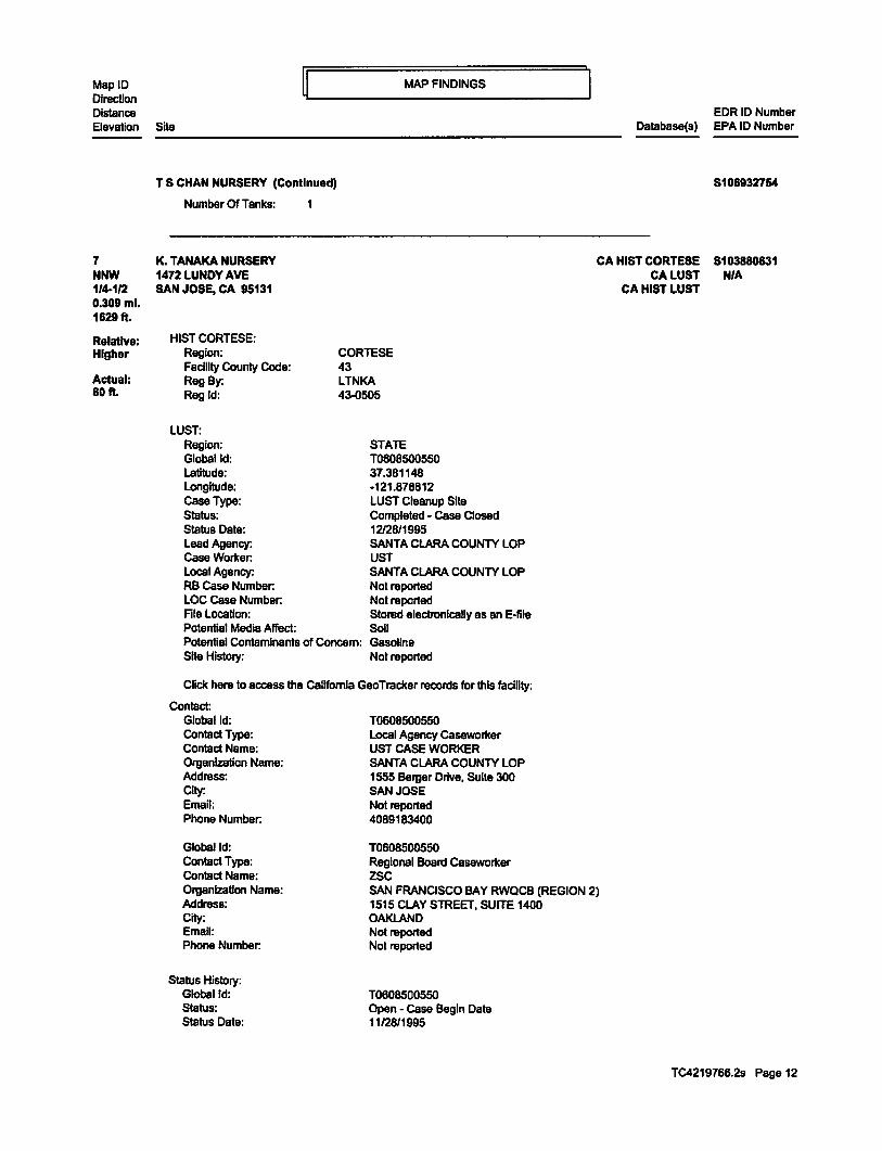
MapiD Direction Distance
~~---------M_AP __ F_I_N_DI_N_G_s __________ ~ EDR ID Number
Elevation Site Database(s) EPA ID Number
7 NNW 1/4-112 0.309ml. 1829 ft.
Relative: Higher
Actual: 80ft.
------------------------------------------------T S CHAN NURSERY (Continued) 8108932754
Number Of Tanks: 1
K. TANAKA NURSERY 1472 LUNDY AVE
CA HfST CORTESE 8103880631
SAN JOSE, CA 95131
HIST CORTESE: Region: Facility County Code: Reg By: Regld:
LUST: Region: Globalld: Latitude: Longitude: Case Type: Status: Status Date: Lead Agency: Case Worker: Local Agency: RB Case Number: LOC Case Number: Ale Location: Potential Media Affect:
CORTESE 43 LTNKA 43..()505
STATE T0608500550 37.381148 ·121.878812 LUST Cleanup Site Completed - Case Closed 12128/1995 SANTA CLARA COUNTY LOP UST SANTA CLARA COUNTY LOP Not reported Not reported Stored electronically as an E·file Soil
Potential Contaminants of Concern: Gasoline Site History: Not reported
Click here to access the California Gao Tracker records for this facility:
Contact: Globalld: T0608500550 Contact Type: Contact Name: Organization Name: Address: City: Email: Phone Number:
Globalld: Contact Type: Contact Name: Organization Name: Address: City: Email: Phone Number:
Status History: Globalld: Status: Status Date:
Local Agency Caseworker UST CASE WORKER SANTA CLARA COUNTY LOP 1555 Berger Drive, Suite 300 SAN JOSE Not reported 4089183400
T0808500550 Regional Board Caseworker zsc SAN FRANCISCO BAY RWQCB (REGION 2) 1515 CLAY STREET, SUITE 1400 OAKLAND Not reported Not reported
T0608500550 Open - Case Begin Date 11/28/1995
CALUST N/A CAHISTLUST
TC4219766.2s Page 12

MapiD Direction Distance Elevation Site
~~----------MAP--__ FI_N_DI_N_G_s __________ ~
K. TANAKA NURSERY (Continued)
Globalid: T0608500550 Status: Status Date:
Regulatory Activities: Globalld: Action Type: Date: Action:
Globalld: Action Type: Data: Action:
Gioballd: Action Type: Dale: Action:
LUS1REG2: Region: 2 FaciHty ld: Not reported
Completed - Case Closed 12/28/1995
10608500550 Other 11128/1995 Leak Reported
10608500550 ENFORCEMENT 12/28/1995 Closure/No Further Action Letter
10608500550 RESPONSE 12/28/1995 Other Report/ Document
Facility Status: Case Closed Case Number: 06S1E29F01f How Discovered: Not reported Leak cause: Not reported Leak Source: Not reported Data Leak Confirmed: Not reported Oversight Program: LUST Prelim. Site Assesment Wokplan SUbmitted: Not reported Preliminary Site Assesment Began: Not reported Pollution Characterization Began: Not reported Pollution Remediation Plan Submitted: Not reported Date Remediation Action Underway: Not reported Date Post Remedial Action Monitoring Began: Not reported
LUST SANTA CLARA: Region: SANTA CLARA SCVWD ID: 06S1 E29F01 F Date Closed: 12128/1995 EDR Unk ID: 06S1 E29F01 F
HIST LUST SANTA CLARA: Region: SANTA CLARA Region Code: 2 SCVWDID: 06S1E29F01 Overslte Agency: SCVWD Date Usted: 1995-12-28 00:00:00 Closed Date: 1995-12-28 00:00:00
EDR ID Number Database(s) EPA ID Number
5103880631
TC4219766.2s Page '\3

MapiD Direction Distance
MAP FINDINGS
Elevation Site
8 SSE 1/4-112 0.343ml. 1809 ft.
Relative: Higher
Actual: 81ft.
NORTH VILLAGE PHASE I 1590 BERRYESSA ROAD SAN JOSE, CA 95131
NPDES: Npdes Number: Facility Status: Agencyld: Region: Regulatory Measure ld: Order No: Regulatory Measure Type: Place ld: WOlD: Program Type: Adoption Date Of Regulatory Measure: Elfective Date Of Regulatory Measure: Expiration Data Of Regulatory Measure: Termination Date Of Regulatory Measure: Discharge Name: Discharge Address: Discharge City: Discharge State: Discharge Zip:
Npdes Number: Facility Status: Agency ld: Region: Regulatory Measure ld: Order No: Regulatory Measure Type: Place ld: WOlD: Program Type: Adoption Date Of Regulatory Measure: Effective Date Of Regulatory Measure: Expiration Date Of Regulatory Measure: Termination Date Of Regulatory Measure: Discharge Name: Discharge Addrass: Discharge City: Discharge Stale: Discharge Zip:
HIST CORTESE: Region: Facility County Code: Reg By: Regld:
LUST:
CORTESE 43 LTNKA 43-1188
CAS000002 Active 0 2 449625 2009-0009-DWQ Enrollee Not reported 243C370957 Construction Not reported 09/2312014 Not reported Not reported KB Home Soulh Bay Inc 5000 Executive Parkway Suite 125 Sen Ramon Califomla 94583
CAS000002 Active 0 2 431729 2009-0009-DWQ Enrollee Not reported 243C364840 Construction Not reported 10119/2012 Not reported Not reported KB Home Soulh Bay Inc 5000 Executive Parkway Suite 125 SanRamon California 94583
Region: Globalld: Latitude: Longitude:
STATE T0608501176 37.3670875678721 -121.876037120819
EDR ID Number Database(s) EPA ID Number
CA NPDES S102808740 CA HIST CORTESE NIA
CALUST CAHISTLUST
CA CUPA Ustlngs
TC4219766.2s Page 14

MapiD Direction Distance
~~----------M_AP ___ FI_N_DI_N_G_s __________ ~ Elevation Site
NORTH VILLAGE PHASE I (Continued)
Case Type: Status: Status Date: Lead Agency: Case Worker: Local Agency: RB Case Number: LOC Case Number: File Location: Potential Media Affect: Potential Contaminants of Concern: Site History:
LUST Cleanup Site Completed • Case Closed 04/04/1996 SANTA CLARA COUNTY LOP UST SANTA CLARA COUNTY LOP Not reported Not reported Stored electronically as an E-tile Other Groundwater (uses other than drinking water) Gasoline Not reported
CHck here to access the California Gao Tracker records for this facility:
Contact: Globalld: Contact Type: Contact Name: Organization Name: Address: City: Email: Phone Number:
Globalld: Contact Type: Contact Name: Organization Name: Address: City: Email: Phone Number:
Status History: Globalld: Status: Status Date:
Globalld: Status: Status Date:
Globalld: Status: Status Date:
Globalld: Status: Status Date:
Regulatory Activities: Globalld: Action Type: Date: Action:
T0608501176 Regional Board Caseworl<er zsc SAN FRANCISCO BAY RWQCB (REGION 2) 1515 CLAY STREET, SUITE 1400 OAKLAND Not reported Not reported
T0608501176 Local Agency Caseworlter UST CASE WORKER SANTA CLARA COUNTY LOP 1555 Berger Drive, Suite 300 SAN JOSE Not reported 4089183400
T0608501176 Open - Site Assessment 09/06/1991
T0608501176 Completed - Case Closed 04/04/1996
T0608501176 Open - Site Assessment 09/01/1985
T0608501176 Open - Case Begin Date 09/0111985
T0608501176 ENFORCEMENT 03122/1991 Notice of Responsibility • #40449
EDR ID Number Database(s) EPA ID Number
8102808740
TC4219766.2s Page 15

MapiD Direction Distance
ij~ _________ MAP ___ F_IN_D_IN_G_s __________ ~
Elevation Site
NORTH VILLAGE PHASE I (Continued)
Globalld: Action Type: Date: Action:
Globalld: Action Type: Date: Action:
Globalld: Action Type: Date: Action:
Globalld: Action Type: Date: Action:
Globalld: Action Type: Date: Action:
Globalld: Action Type: Date: Action:
Globalld: Action Type: Date: Action:
Globalld: Action Typa: Date: Action:
Globalld: Action Type: Date: Action:
Globalld: Action Type: Date: Action:
Globalld: Action Type: Date: Action:
Globalld: Action Type:
T0608501176 ENFORCEMENT 07/03/1990 Staff Letter- #33195
T0608501176 ENFORCEMENT 10122/1999 Staff Letter- #33210
T0608501176 ENFORCEMENT 08131/1993 Staff Letter- #33189
T0608501176 Other 0811711990 Leak Reported
T0608501176 ENFORCEMENT 04104/1996 Closure/No Further Action Letter
T0608501176 RESPONSE 10/1511993 Monitoring Report - Quarterly
TOBOB501176 RESPONSE 04/15/1995 Monitoring Report - Quarterly
T0608501176 RESPONSE 07/1511994 Monitoring Report - Quarterly
T0608501176 RESPONSE 10/2611999 Soli and Water Investigation Workplan
T0608501176 RESPONSE 01/1511994 Monitoring Report - Quarterly
T0608501176 RESPONSE 04/1511994 Monitoring Report - Quarterly
T0608501176 RESPONSE
EDR ID Number Database(s) EPA ID Number
8102808740
TC4219766.2s Page 16

MapiD Direction Distance Elevation Site
NORTH VILLAGE PHASE I (Continued)
Date: Action:
Globalld: Action Type: Date: Action:
Globalld: Action Type: Date: Action:
Globalld: Action Type: Date: Action:
Globalld: Action Type: Date: Action:
Region: Globalld: Latitude: Longitude: Case Type: Status: Status Date: Lead Agency: Case Worker: Local Agency: RB case Number: LOC Case Number: File Location: Potential Media Affect: Potential Contaminants of Concem: Site History:
MAP FINDINGS
10/15/1994 Monitoring Report • Quarterly
T0608501176 RESPONSE 01/15/1995 Monitoring Report - Quarterly
T0608501176 RESPONSE 07/15/1995 Monitoring Report - Quarterly
T0608501176 RESPONSE 10/1511995 Monitoring Report - Quarterly
T0608501176 RESPONSE 04/04/1996 Other Report I Document
STATE T0608502408 37.3695432708879 -121.8n388954163 LUST Cleanup Site Completed • Case Closed 10130/2000 SANTA CLARA COUNTY LOP UST SANTA CLARA COUNTY LOP Not reported Not reported Stored electronically as an E·flle Other Groundwater (uses other than drinking water) Gasoline Not reported
Click here to access the California Gao Tracker records for this facility:
Contact: Globalld: Contact Type: Contact Name: Organization Name: Address: City: Email: Phone Number:
Globalld: Contact Type: Contact Name: Organization Name: Address:
T0608502406 Regional Board Casewortcer zsc SAN FRANCISCO BAY RWQCB (REGION 2) 1515 CLAY STREET, SUITE 1400 OAKLAND Not reported Not reported
T0608502408 Local Agency Caseworl<er UST CASE WORKER SANTA CLARA COUNTY LOP 1555 Berger Drive, Suite 300
EDR ID Number Database(s) EPA ID Number
5102808740
TC4219788.2s Page 17

MapiD Direction Distance
MAP FINDINGS
Elevation Site
NORTH VILlAGE PHASE I (ContJnued)
City: SAN JOSE Email: Not reported Phone Number: 4089183400
Status History: Globalld: Status: Status Date:
Globalld: Status: Status Date:
Globalld: Status: Status Date:
Globalld: Status: Status Date:
Regulatory Activities: Globalld: Acllon Type: Date: Action:
Globalld: Action Type: Data: Action:
Globalld: Action Type: Date: Action:
Globalld: Action Type: Date: Action:
Globalld: Action Type: Date: Action:
lUSTREG2: Region: Facility ld: Facility Status: Case Number: How Discovered: Leak Cause: leak Source:
2
T0608502408 Open • Site Assessment 04/28/1999
T0608502408 Open • Site Assessment 0612411999
T0608502408 Completad • Case Closed 10/30/2000
T0608502408 Open • Case Begin Date 04/07/1999
T0608502408 Other 04/07/1999 Leak Reported
T060850240B RESPONSE 12/17/1999 Soli and Water Investigation Report
T0608502408 RESPONSE 07/24/2000 Other Report I Document
T0608502408 ENFORCEMENT 09/18/1999 Staff Letter· #32950
T0608502408 ENFORCEMENT 07120/2000 Staff letter· #32953
Not reported Case Closed 06S1E32H01f Not reported Not reported Not reported
EDR ID Number Database(s) EPA ID Number
8102808740
TC4219766.2s Page 18

MapiD Direction Distance
ij~ __________ M_AP __ F_IN_D_IN_G_s __________ ~
Elevation Site
NORTH VILLAGE PHASE I (ConUnued)
Date Leak Confirmed: Not reported Oversight Program: LUST Prelim. Site Assesment Wokplan Submitted: Not reported Preliminary Site Assesment Began: 9/1/1985 PoUution Characterization Began: 9/6/1991 Pollution Remediation Plan Submitted: Not reported Date Remediation Action Underway: Not reported Date Post Remedial Action Monitoring Began: Not reported
Region: 2 Faa11ty ld: Not reported Facility Status: Case Closed Case Number: 06S1E33E01f How Discovered: Not reported Leak Cause: Not reported Leak Source: Not reported Date Leak Confirmed: Not reported Oversight Program: LUST Prelim. Site Assesment Wokplan Submitted: Not reported Preliminary Site Assesment Began: 412811999 Pollution Characterization Began: 6/24/1999 Pollution Remediation Plan Submitted: Not reported Date Remediation Action Underway: Not reported Date Post Remedial Action Monitoring Began: Not reported
LUST SANTA CLARA: Region: SANTA CLARA SCVVVDID: 06S1E33E01F Date Closed: 10130/2000 EDR Link ID: 06S1E33E01F
Region: SCVVVD ID: Date Closed: EDRUnkiD:
SANTA CLARA 06S1E32H01F 04/04/1996 06S1E32H01F
HIST LUST SANTA CLARA: Region: SANTA CLARA Region Code: 2 SCVVVD ID: 06S1E32H01 Oversite Agency: SCVWO Date Listed: 1991.()3-21 00:00:00 Closed Date: 1996-04-04 00:00:00
Region: SANTA CLARA Region Code: 2 SCVVVD ID: 06S1E33E01 Overslte Agency: SCVWD Date Listed: 1999-08-20 00:00:00 Closed Date: 200D-10-30 00:00:00
CUPA SANTA CLARA: Region: PE#: Program Description:
SANTA CLARA 2205 GENERATES 100 KG YR TO <5 TONSNR
EDR ID Number Database(s) EPA ID Number
8102808740
TC4219766.2s Page 19

MapiD Direction Distance
~~----------MAP----FI_N_DI_N_G_s __________ ~ Elevation Site
9 North 1/4-112 0.399ml. 2108 ft.
Relative: Higher
Actual: 88ft.
NORTH VILLAGE PHASE I (Continued)
Region: PE#: Program Oescrlptlon:
Region: PE#: Program Description:
WESTERN PACIFIC RAILROAD 900 EAST WILUAMS SANJOSE,CA
SLIC: Region: Facility Status: Status Date: Globalld: Lead Agency: Lead Agency case Number: Latitude: Longitude: Case Type: Case Wol1<er: Local Agency: RB case Number: File Location: Potential Media Affected:
SANTA CLARA 2399 UNDERGROUND STORAGE TANK PROGRAM RECORD
SANTA CLARA BP06 HMBP FACILITY, 22+ CHEMICALS
STATE Open • Inactive 07114/2010 SL18265686 SAN FRANCISCO BAY RWQCB (REGION 2) Not reported 37.385815 -121.880046 Cleanup Progrem Site UNA
Potential Contaminants of Concern:
Not reported 43S0761 Not reported Not reported Not reported Not reported Site History:
Click here to access the Csllfomia Gao Tracker records for this facility:
SLICREG2: Region: 2 Facility ID: SL 18265686 Facility Status: Not reported Date Closed: Not reported Local case #: Not reported How Discovered: Not reported Leak cause: Not reported Leak Source: Not reported Date Conflnned: Not reported Date Prelim Site Assmnt Wol1<plan Submitted: Not reported Date PrellminaJY Site Assessment Began: Not reported Date Pollution Charecterlzatlon Began: Not reported Date Remediation Plan Submitted: Not reported Date Remedial Action Underway: Not reported Date Poet Remedial Action Monitoring Began: Not reported
EDR ID Number Database(&) EPA ID Number
8102808740
cA sue 8108235149 N/A
TC4219766.2s Pege 20

MapiD Direction Distance Elevation Site
MAP FINDINGS
EOR 10 Number Oatabase(s) EPA 10 Number
10 FACCHINO FREIGHT UNES 1855 BERRYESSA
CA HIST CORTESE U001603097 SSE 1/4-1/2 0.445ml. 2349 ft.
Relative: Higher
Actual: 83ft.
SAN JOSE. CA 95133
HIST CORTESE: Region: Facility County Code: Reg By: Regld:
LUST:
CORTESE 43 LTNKA 43-0553
Region: STATE Global ld: 10608500595 Latitude: 37.3641 Longitude: -121.8844 Case Type: LUST Cleanup Site Status: Completed - case Closed Status Data: 12106/1996 Lead Agency: SANTA CLARA COUNTY LOP Case Worker: UST Local Agency: SANTA CLARA COUNTY LOP RB Case Number: Not reported LOC Case Number: Not reported File Location: Stored eledronlcaUy as an E-file
CALUST N/A CAHISTLUST
CAHISTUST
Potential Media Affect Other Groundwater (uses other than drinking water) Potential Contaminants of Concem: Diesel Site History: Not reported
Click here to access the California Gao Tracker records for this facility:
Contact: Globalld: Contact Type: Contact Name: Organization Name: Address: City: Email: Phone Number:
Globalld: Contact Type: Contact Name: Organization Name: Address: City: Email: Phone Number:
Status History: Globalld: Status: Status Date:
Globalld: Status: Status Date:
T0608500595 Regional Board Caseworker zsc SAN FRANCISCO BAY RWQCB (REGION 2) 1515 CLAY STREET, SUITE 1400 OAKLAND Not reported Not reported
T0608500595 Local Agency Caseworker UST CASE WORKER SANTA CLARA COUNTY LOP 1555 Berger Drive, SUite 300 SAN JOSE Not reported 4089183400
T0608500595 Open - Case Begin Date 04/20/1988
10608500595 Open - Site Assessment 11/09/1992
TC4219766.2s Page 21

MapiD Direction Distance Elevation SHe
MAP FINDINGS
FACCHINO FREIGHT UNES (Continued)
Globalld: Status: Status Date:
Globalld: Status: Status Date:
Regulatory Activities: Globalld: Action Type: Date: Action:
Globalld: Action Type: Dale: Action:
Globalld: Action Type: Date: Action:
LUSTREG2: Region: 2
T0608500595 Completed - case Closed 12106/1996
T0608500595 Open - Site Assessment 07127/1988
T0608500595 Other 04/20/1988 Leak Reported
T0608500595 ENFORCEMENT 06124/1993 Notice of Violation - #40442
T0608500595 REMEDIATION 12122/1987 Excavation
Facility ld: Not reported Facility Status: Case Closed Case Number: 06S1E32A01f How Discovered: Not reported Leak Cause: Not reported Leak Source: Not reported Date Leak Conflnned: Not reported Oversight Program: LUST Prelim. Site Assesment Wokplan Submitted: Not reported Preliminary Site Assesment Began: 7/27/1988 Pollution Characterization Began: 11/9/1992 Pollution Remediation Plan Submitted: Not reported Dale Remediation Action Underway: Not reported Date Post Remedial Action Monitoring Began: Not reported
LUST SANTA CLARA: Region: SANTA CLARA SCVVVDID: 06S1E32A01F Date Closed: 12106/1996 EDR Link ID: 06S1E32A01F
HIST LUST SANTA CLARA: Region: SANTA CLARA Region Code: 2 SCVVVDID: 06S1E32A01 Overslte Agency: SCVWD Date Listed: 1989-01-01 00:00:00 Closed Date: 1996-12-06 00:00:00
EDR ID Number Database(s) EPA ID Number
U001803097
TC4219766.2s Page 22

MapiD Dlrecllon Distance Elevation Site
MAP FINDINGS
FACCHINO FREIGHT UNES (Continued)
HISTUST: Region: Feciftty ID: Facility Type: other Type: Contact Name: Telephone: OWner Name: OWner Address: Owner City,St.llp: Total Tanks:
TankNum: Container Num: Year Installed: Tank Capacity: Tank Used for: Type of Fuel: Container Construction Thickness: Leak Detection:
TankNum: Container Num: Year Installed: Tank Capacity: Tank Used for: Type of Fuel: Container Construction Thickness: Leak Detection:
TankNum: Container Num: Year Installed: Tank Capacity: Tank Used for: Type of Fuel: Container Construction Thickness: leak Detection:
TankNum: Container Num: Year Installed: Tank Capacity: Tank Used for: Type of Fuel: Container Construction Thickness: leak Detection:
STATE 00000011173 other TRUCKING Not reported 4082874433 BERNARD J. FACCHINO 1655 BERRYESSA RD SAN JOSE, CA 95133 0004
001 #1 1974 00010000 PRODUCT DIESEL Not reported Stock Inventor
002 #2 1974 00010000 WASTE REGULAR Not reported Stock Inventor
003 #3 1974 00001000 WASTE WASTE OIL Not reported Stock Inventor
004 #4 1974 00004000 PRODUCT Not reported Not reported Stock Inventor
EDR ID Number Database(s) EPA ID Number
U001603097
TC4219766.2s Page 23

MapiD Direction Distance
MAP FINDINGS
Elevation Site EDR ID Number
Databese(s) EPA ID Number
811 SE 1/4-112 0.469 mi. 2476ft.
Relative: Higher
Actual: 89ft.
SHELL SERVICE STATION 1705 BERRYESSA SAN JOSE, CA 95150
Site 1 of 5 In cluster B
RCRA-SQG: Date form received by agency: 09/0312002 Facility name: Facility address:
EPAID: Mailing address:
Contact Contact address:
Contact country: Contact telephone: Contact email: EPA Region: Classification:
SHELL SERVICE STATION 1705 BERRVESSA SAP 136010 SAN JOSE, CA 95150 CAR000127373 POBOX2648 HOUSTON, TX 772522648 SONDRA BIENVENU POBOX2648 HOUSTON, TX 772522648 us (713) 241-5036 Not reported 09 Small Small Quantity Generator
RCRA..SQG 1005904522 CA LUST CAR000127373
CA CUPA Listings CAHAZNET
Description: Handler: generates more than 100 and less than 1000 kg of hazardous waste during any calendar month and accumulates less than 6000 kg of hazardous waste at any time; or generates 100 kg or less of hazardous waste during any calendar month, and accumulates more than 1000 kg of hazardous waste at any time
Owner/Operator Summary: Owner/operator name: Owner/operator address:
Owner/operator country: Oovner/operator telephone: Legal status: Owner/Operator Type: Owner/Op start date: Owner/Op end date:
Handler Activities Summary:
EQUILON ENTERPRISES LLC DBA POBOX2648 HOUSTON, TX 77252 Not reported (713) 241-5036 Private Owner Not reported Not reported
U.S. Importer of hazardous waste: No Mixed waste (haz. and radioactive): No Recycler of hazardous waste: No Transporter of hazardous waste: No Treater, storar or disposer of HW: No Underground Injection activity: No On-site bumer exemption: No Fumace exemption: No Used oil fuel bumer: No Used oil processor: No User oil reflner: No Used oil fuel marketer to bumer: No Used oil Specification marketer: No Used oil transfer facility: No Used oil transporter: No
TC4219766.2s Page 24

MapiD Direction Distance
ij~ _________ MAP ___ F_I_ND_I_N_G_s __________ _J
EDR ID Number Elevation Site Database(s) EPA ID Number
SHELL SERVICE STAnON (Continued) 1005904522
Hazardous Waste Summary: Waste code: Waste name:
Waste code: Waste name:
Violation Status:
LUST: Region: Globelld: Latitude: Longitude: Case Type: Status: Status Date: Lead Agency: Case Worker: Local Agency: RB case Number: LOC Case Number: Ale Location: Potential Media Affect:
D001 IGNITABLE HAZARDOUS WASTES ARE THOSE WASTES WHICH HAVE A FLASHPOINT OF LESS THAN 140 DEGREES FAHRENHEIT AS DETERMINED BY A PENSKY-MARTENS CLOSED CUP FLASH POINT TESTER. ANOTHER METHOD OF DETERMINING THE FLASH POINT OF A WASTE IS TO REVIEW THE MATERIAl SAFETY DATA SHEET, WHICH CAN BE OBTAINED FROM THE MANUFACTURER OR DISTRIBUTOR OF THE MATERIAL. LACQUER THINNER IS AN EXAMPLE OF A COMMONLY USED SOL VENT WHICH WOULD BE CONSIDERED AS IGNITABLE HAZARDOUS WASTE.
D018 BENZENE
No violations found
STATE T0608501266 37.37395992326 -121.873655319214 LUST Cleanup Site Completed - Case Closed 07/23/1996 SANTA CLARA COUNTY LOP UST SANTA CLARA COUNTY LOP Not reported Not reported Stored electronically as an E-file
Potential Contaminants of Concern: Other Groundwater (uses other than drinking water) Gasoline
Site History: Not reported
Click here to access the california GeoTrecker records for this facility:
Contact: Globalld: Contact Type: Contact Name: Organization Name: Address: City: Email: Phone Number:
Globalld: Contact Type: Contact Name: Organization Name: Address: City: Email: Phone Number:
Sta1us History: Globalld: Status:
T0608501266 Local Agency C888WCJf1(er UST CASE WORKER SANTA CLARA COUNTY LOP 1555 Berger Drive, Suite 300 SAN JOSE Not reported 4089183400
10608501266 Regional Board caseworker zsc SAN FRANCISCO BAY RWQCB (REGION 2) 1515 CLAY STREET, SUITE 1400 OAKLAND Not reported Not reported
T0608501266 Open • case Begin Date
TC4219766.2s Page 25

MapiD Direction Distance Elevation Site
ij~ _________ MAP ___ F_I_ND_I_N_G_s __________ ~·~ EDR ID Number
Databasa(s) EPA ID Number
SHELL SERVICE STATION (Continued) 1005904522
Status Data: 07/14/1987
Globalld: T0608501266 Status: Open - Site Assessment Status Data: 07/14/1987
Globalld: T0608501266 Status: Completed - Case Closed Status Data: 0712311996
Regulatory Activities: Global ld: T0608501266 Acllon Type: Other Data: 06/2711991 Acllon: Leak Reported
Globalld: T0608501266 AcUonTypa: RESPONSE Data: 0711511996 AcUon: Remedial Progress Report
Globalld: T0608501266 Action Type: RESPONSE Data: 07/15/1995 Action: MonHoring Report - Quarterly
Globalld: T0608501266 Action Type: RESPONSE Data: 10/15/1996 Action: MonHoring Report - Quarterly
Global ld: T0608501266 Action Type: RESPONSE Data: 01115/1996 Action: Monitoring Report - Quarterly
Globalld: T0608501266 Action Type: RESPONSE Data: 04/1511996 Action: Monitoring Report - Quarterly
Globalld: T0608501266 Action Type: RESPONSE Data: 10/1511999 Action: MonHoring Report - Quarterly
Global let: T0608501266 Action Type: REMEDIATION Data: 07/14/1987 Action: Excavation
Globalld: T0808501266 Action Type: ENFORCEMENT Date: 01/11/1992 Action: Notice of Rasponslbi!Hy- #40473
Globalld: T0608501266
TC4219766.2s Page 26

MapiD Direction Distance
~~----------MAP--_F_I_N_DI_N_G_s __________ ~ Elevation Site ------------------------------------------------
SHELL SERVICE STAnON (Continued)
~onT~: ENFORCEMENT Date: 05/17/1996 Action: Staff Letter· #33053
Globalld: ~on Type: Date: Action:
T0608501266 ENFORCEMENT 05131/1995 Staff Letter· #33044
Region: STATE Globalld: T0608502428 Latitude: 37.373848 Longitude: -121.873829 Case Type: LUST Cleanup Site Status: Completed - Case Closed Status Date: 08/0312010 Lead Agency: SANTA CLARA COUNTY LOP case Wolter: Not reported locel Agency: Not reported RB Case Number: 19-110 LOC Case Number: 06S1E33D03f File Locetion: Stored electronically as an E·file Potential Media Affect: Other Groundwater (uses other than drinking water) Potential Contaminants of Concern: Gasoline Site History: Not reported
Click here to access the california Geo Tracker records for this facility:
Contact: Globalld: ContactT~: Contact Name: Organization Name: Address: City: Email: Phone Number:
Status History: Globalld: Status: Status Date:
Globalld: Status: Status Date:
Globalld: Status: Status Date:
Globalld: Status: Status Date:
Globalld:
T0608502428 Regional Board casewortter NATHAN KING SAN FRANCISCO BAY RWQCB (REGION 2) 1515 CLAY ST., SUITE 1400 OAKLAND [email protected] Not reported
T0608502428 Open • Site Assessment 01/19/1999
T0608502428 Open • Site Assessment 06123/1999
T0606502428 Completed - case Closed 08/0312010
T0608502428 Open • case Begin Date 01119/1999
T0608502426
EDR ID Number Database(s) EPA ID Number
1005904522
TC4219766.2s Page 27

MapiD Direction Distance Elevation Site
MAP FINDINGS
EDR ID Number Database(s) EPA ID Number
SHELL SERVICE STATION (Continued} 1005904522
Status: Open - Remediation Status Date: 09/24/2002
Regulatory Actlvllies: Globalld: T0608502428 Action Type: Other Date: 02/09/1999 Action: Leak Reported
Globalld: T0608502428 Action Type: ENFORCEMENT Data: 12124/2009 Action: Staff Letter
Globalld: T0608502428 Action Type: ENFORCEMENT Date: 08/31/1999 Action: Staff letter- #33105
Globalld: T0608502428 Action Type: ENFORCEMENT Date: 03101/2001 Action: Staff Letter- #33155
Globalld: T0608502428 Action Type: RESPONSE Date: 10/1511999 Action: Monitoring Report - Quarterly
Globalld: T0608502428 Action Type: Other Date: 02/0511999 Action: leak Discovery
Globalld: T0608502428 Action Type: RESPONSE Date: 10/15/2001 Action: Monitoring Report - Quarterly
Globalld: T0608502428 Action Type: RESPONSE Data: 06/30/2010 Action: Well Des1ruction Report
Globalld: T0608502428 Action Type: ENFORCEMENT Date: 09/0812009 Action: Steff Letter
Globalld: T0608502428 Action Type: ENFORCEMENT Date: 12124/2009 Action: Staff letter
Globalld: T0608502428 Action Type: Other Date: 02/0511999
TC4219766.2s Page 28

MapiD Direction Distance
MAP FINDINGS
Elevation Site
SHELL SERVICE STAnON (Continued)
Action:
Globalld: Action Type: Date: Action:
Globalld: Action Type: Date: Action:
Globalld: Action Type: Date: Action:
Globalld: Action Type: Date: Action:
Globalld: Action Type: Date: Action:
LUST SANTA CLARA:
Leak Stopped
10608502428 REMEDIATION 07/09/2002 Pump & Treat (P&T) Groundwater
T0608502428 ENFORCEMENT 05127/2010 Staff Letter
T0608502428 RESPONSE 04/1512001 Monitoring Report - Quarterly
T0608502428 RESPONSE 07115/2001 Monitoring Report - Quarterly
T0608502428 ENFORCEMENT 0810312010 Closure/No Further Action Letter
Region: SANTA CLARA SC~ID: 06S1E33D03F Date Closed: 08103/2010 EDR Unk ID: 06S1E33D03F
Region: SC~ID:
Date Closed: EDRUnkiD:
SANTA CLARA 06S1 E33D01 F 07/23/1996 06S1E33D01F
CUPA SANTA CLARA: Region: PE#: Program Description:
Region: PE#: Program Description:
Region: PE#: Program Description:
HAZNET: envid: Year: GEPAID:
SANTA CLARA 2202 GENERATES< 100 KGIYR
SANTA CLARA 2399 UNDERGROUNDSTORAGETANKPROGRAMRECORD
SANTA CLARA BP02 HMBP FACILITY, 4-6 CHEMICALS
1005904522 2010 CAR000127373
EDR ID Number Database(s) EPA ID Number
1005904522
TC4219766.2s Page 29

MapiD Direction Distance
MAP FINDINGS
Elevation Site ------------------------------------------SHELL SERVICE STATION (Continued)
Conlact: Telephone: Mailing Name: Mailing Address: Maftlng Clty,St,Zlp: GenCounty: TSDEPAID: TSDCounty: Waste Category: Disposal Method: Tons: Facility County:
envld: Year: GEPAID: Contact: Telephone: Mailing Name: Mailing Address: Mailing City,St,Zlp: GenCounty: TSDEPAID: TSDCounty: Waste Category: Disposal Method: Tons: Facility County:
envld: Year: GEPAID: Conlact: Telephone: MaiUng Name: Mailing Address: MaiHng City,St,Zip: GenCounty: TSDEPAID: TSDCounty: Waste Category: Disposal Method:
Tons: Facility County:
envld: Year: GEPAID: Contact: Telephone: Mailing Name: Mailing Address: Mailing City,St,Zlp: GenCounty: TSDEPAID: TSDCounty:
J. TrayloriENV REPORTING ANALYST 7132416992 Not reported POBOX3127 HOUSTON, TX n2530000 Not reported UTD981552177 Not reported Other organic solids Not reported 0.2 Santa Clara
1005904522 2010 CAR000127373 J. Traylor/ENV REPORTING ANALYST 7132416992 Not reported POBOX3127 HOUSTON, TX n2530000 Not reported UTD9815521n Not reported Other organic solids Not reported 0.2 Santa Clara
1005904522 2009 CAR000127373 R HULL/ENV. REPORTING ANALYST 2818742224 Not reported 12700 NORTHBOROUGH DR 300G03 Houston, TX n0670000 Not reported CAD008302903 Not reported Other organic solids Storage, Bulking, And/Or Transfer Off Site-No TreatmentJReovery (H010-H129) Or (H131-H135) 0.125 Santa Clara
1005904522 2009 CAR000127373 R HULLIENV. REPORTING ANALYST 2818742224 Not reported 12700 NORTHBOROUGH DR 300G03 Houston, TX n0670000 Not reported CAD008302903 Not reported
EDR ID Number Database(s) EPA 10 Number
1005904522
TC4219766.2s Page 30

MapiD ij Direction '--------------------1
MAP FINDINGS
Distance Elevation Site
SHELL SERVICE STAnON (Continued)
Waste Category: Disposal Method:
Tons: Facility County:
envid: Year: GEPAID: Contact: Telephone: Mailing Name: Mailing Address:
Other organic solids Storage, Bulking, And/Or Transfer Off Site-No Treatment/Reovery (H010-H129) Or (H131·H135) 0.125 Santa Clara
1005904522 2008 CAR000127373 R HULUENV. REPORTING ANALYST 2818742224 Not reported
MaRing Clty,St,Zlp: 12700 NORTHBOROUGH DR 300G03 Houston, TX 770670000
GenCounty: TSDEPAID: TSDCounty: Waste Category: Disposal Method:
Tons: FacUlty County:
Not reported CAD008830290 Not reported Other organic solids Storage, Bulking, And/Or Transfer Off Site-No TreatmenUReovery (H010-H129) Or (H131·H135) 0.02 Santa Clara
Click this N1perl!nk while viewing on your computer to access 19 additional CA_HAZNET: record(s) In the EDR Site Report.
EDR ID Number Database(s) EPA ID Number
1005904522
812 SHELL CA HIST CORTESE S105126367 SE 1/.t.112 0.469ml. 2478ft.
Relative: Higher
Actual: 89ft.
1705 BERRYESSA RD SAN JOSE, CA 95118
Site 2 of 5 In cluster B
HIST CORTESE: Region: FaciUty County Code: Reg By: Regld:
LUSTREG2: Region: 2
CORTESE Not reported Not reported Not reported
Facility ld: Not reported Facility Status: Pollution Characterization Case Number: 06S1E33003f How Discovered: Not reported Leak Cause: Not reported Leek Source: Not reported Date Leak Confirmed: Not reported Oversight Program: LUST Prelim. Site Assesment Wokplan Submitted: Not reported Preliminary Site Assesment Began: 1/1911999 Pollution Characterization Began: 612311999 Pollution Remediation Plan Submitted: Not reported Date Remediation Action Underway: Not reported Date Post Remedial Action Monitoring Began: Not reported
HIST LUST SANTA CLARA: Region: SANTA CLARA
CALUST N/A CAHISTLUST
TC4219766.2s Page 31

MapiD Oirectlon Distance Elevation Site
MAP FINDINGS
B13 SE 1/4-1/2 0.469ml. 2476 ft.
Relative: Higher
Actual: 89ft.
B14 SE 1/4-112 0.471 mi. 2487ft.
Relatlvs: Higher
Actual: 90ft.
SHELL (Contlnu&d)
Region Code: 2 SCVWO ID: 06S1 E33D03 Overslte Agency: SCCDEH Date Listed: 1999-03-15 00:00:00 Closed Date: Not reported
SHELL OIL COMPANY 1705 BERRYESSA RD SAN JOSE. CA 95133
Site 3 of 5 In cluster B
LUSTREG2: Region: 2 Facility ld: Not reported Facility Status: Cese Closed C8se Number: 06S1E33001f How Discovered: Not reported Leak cause: Not reported Leak Source: Not reported Date Leak Confirmed: Not reported Oversight Program: LUST Prelim. Site Assesment Wokplan Submitted: Not reported Preliminary Site Assesment Began: 711411987 Pollution Characterization Began: 7/1411987 Pollution Remediation Plan Submitted: Not reported Date Remediation Action Underway: Not reported Date Post Remedial Action Monitoring Began: Not reported
HIST LUST SANTA CLARA: Region: SANTA CLARA Region Code: 2 SCVWD ID: 06S1E33D01 Overslte Agency: SCVWD Date Listed: 1992..01..01 00:00:00 Closed Date: 1996..()7-23 00:00:00
BCAUTOCARE 1715 BERRYESSA RD SAN JOSE. CA 95133
Site 4 of 5 In cluster B
HIST CORTESE: Region: Facility County Code: Reg By: Regld:
LUST: Region: Globalld: Latitude: Longitude: CsseType:
CORTESE 43 LTNKA 43-0296
STATE T0608500353 37.3743521230633 -121.872990131378 LUST Cleanup Site
EDR ID Number Database(s) EPA ID Number
8105126367
CA LUST S105512912 CA HIST LUST NIA
CA HIST CORTESE 8110080472 CALUST NIA
CA CUPA Listings CA SAN JOSE HAZMAT
TC4219766.2s Page 32

MapiD Direction Distance
ij~ __________ M_AP ___ FI_N_DI_N_G_s __________ _J
Elevation Site
BC AUTO CARE (Continued)
Status: Status Date: Lead Agency: case Worker: Local Agency: RB Case Number: LOC Case Number: File Location: Potential Media Affect: Potential Contaminants of Concem: Site History:
Completed - case Closed 02/1412005 SANTA CLARA COUNTY LOP UST SANTA CLARA COUNTY LOP Not reported Not reported Stored electronically as an E-file Other Groundwater (uses other than drinking water) Gasoline Not reported
Click here to access the California Gao Tracker records for this facility:
Contact: Globalld: Contact Type: Contact Name: Organization Name: Address: City: Email: Phone Number:
Globalld: Contact Type: Contact Name: Organization Name: Address: City: Email: Phone Number:
Status History: Globalld: Status: Status Date:
Globalld: Status: Status Date:
Globalld: Status: Status Date:
Globalld: Status: Status Date:
Global ld: Status: Status Date:
Regulatory Activities: Globalld: Action Type:
T0608500353 Regional Board Caseworf(er zsc SAN FRANCISCO BAY RWQCB (REGION 2) 1515 CLAY STREET, SUITE 1400 OAKLAND Not reported Not reported
T0608500353 Local Agency Caseworker UST CASE WORKER SANTA CLARA COUNTY LOP 1555 Berger Drive, Suite 300 SAN JOSE Not reported 4089183400
T0608500353 Open - Verification Monitoring 06/01/1992
T0608500353 Open - SHe Assessment 10/01/1984
T0606500353 Open - Site Assessment 06/0111989
T0608500353 Completed - Case Closed 02114/2005
T0608500353 Open - Case Begin Date 10/01/1984
T0608500353 ENFORCEMENT
EDR ID Number Database(s) EPA ID Number
8110060472
TC4219766.2s Page 33

MapiD Directlcn Distance Elevation Site
BC AUTO CARE (Continued)
Date: Action:
Globalld: Action Type: Date: Action:
Globalld: Action Type: Date: Action:
Globalld: Action Type: Date: Action:
Globalld: Action Type: Date: Action:
Globalld: Action Type: Date: Action:
Globalld: Action Type: Date: Action:
Globalld: Action Type: Date: Action:
Globalld: Action Type: Date: Action:
Globalld: Action Type: Date: Action:
Globalld: Action Type: Date: Action:
Globalld: Action Type: Date: Action:
MAP FINDINGS
08/28/1996 Staff Letter • #33072
T0608500353 ENFORCEMENT 02/2311996 Staff Letter • #33068
T0608500353 ENFORCEMENT 08130/1989 Staff Letter • #33059
TC608500353 Other 10/0111984 Leak Reported
T0608500353 RESPONSE 11/0812001 Soli and Water Investigation Report
T0608500353 RESPONSE 08/31/2001 Soil and Water lnvastigation Workplan
T0608500353 RESPONSE 07/15/2001 Soil and Water Investigation Report
T0608500353 RESPONSE 12/1311999 Other Report I Document
T0608500353 RESPONSE 06/19/1999 Soli and Water Investigation Worilplan
T0608500353 ENFORCEMENT 03117/1999 Staff Letter- #330n
T0608500353 ENFORCEMENT 08/02/2004 Staff Letter - #44493
T0608500353 ENFORCEMENT 07/2512001 Staff Letter· #33091
EDR ID Number Database(s) EPA ID Number
8110080472
TC4219768.2s Page 34

MapiD ij MAP FINDINGS Direction Distance EDR ID Number Elevation Site Database(s) EPA ID Number
BC AUTO CARE (Continued) 8110060472
Globalld: T0608500353 Action Type: ENFORCEMENT Date: 05105/1999 Action: Staff Letter - #33079
Globalld: T0608500353 Action Type: ENFORCEMENT Date: 02/14/2005 Action: Closure/No Further Action Letter
Globalld: T0608500353 Action Type: RESPONSE Date: 0713112003 Action: Monitoring Report - Quarterly
Globalld: T0608500353 Action Type: RESPONSE Date: 04/30/2004 Action: Monitoring Report - Quarterly
Globalld: T0608500353 Action Type: RESPONSE Date: 0413011997 Action: Monitoring Report - Quarterly
Globalld: T0608500353 Action Type: RESPONSE Date: 12/12/1996 Action: Monitoring Report - Quarterly
Globalld: T0608500353 Action Type: RESPONSE Date: 12131/2004 Action: Other Report I Document
Globalld: 10608500353 Action Type: RESPONSE Date: 07/30/2002 Action: Monitoring Report - Quarterly
Globalld: T0608500353 Action Type: RESPONSE Date: 07131/2004 Action: Monitoring Report - Quarterly
Glcballd: T0608500353 Action Type: RESPONSE Date: 0113012003 Action: Monitoring Report - Quarterly
Globalld: T0608500353 Action Type: RESPONSE Date: 0413012003 Action: Monitoring Report - Quarterly
Globalld: T0608500353 Action Type: RESPONSE
TC4219766.2s Page 35

MapiD Direction Distance Elevation Site
ij~ __________ MAP ____ FI_N_DI_N_G_s __________ ~
BC AUTO CARE (Continued)
Date: 1013112003 Action: Monitoring Report • Quarterly
G!oballd: T0608500353 Action Type: RESPONSE Date: 08131/1989 Action: Other Report I DoaJment
Globalld: T0608500353 Action Type: RESPONSE Date: 10/3112004 Action: Monitoring Report • Quarterly
Globalld: T0608500353 Action Type: RESPONSE Date: 0113112004 Action: Monitoring Report • Quarterly
Globalld: T0608500353 Action Type: RESPONSE Date: 04/3012001 Action: Monitoring Report • Quarterly
Globalld: T0608500353 Action Type: RESPONSE Date: 04130/1999 Action: Monitoring Report • Quarterly
Globalld: T0608500353 Action Type: RESPONSE Date: 10/3112000 Action: Monitoring Report • Quarterly
G!oballd: T0608500353 Action Type: RESPONSE Date: 0113012001 Action: Monitoring Report • Quarterly
Globalld: T0608500353 Action Type: ENFORCEMENT Date: 02121/1997 Action: Staff Letter • #3307 4
Globalld: T0608500353 Action Type: ENFORCEMENT Date: 05128/1996 Action: Staff letter· #33070
Globalld: T0608500353 Action Type: ENFORCEMENT Date: 08/31/1994 Action: Staff letter· #33063
G!oba!ld: T0608500353 Action Type: ENFORCEMENT Date: 06/1911989 Action: Staff Letter· #33061
EDR ID Number Database(&) EPA ID Number
8110060472
TC4219766.2s Page 36

MapiD Direction Distance Elevation Site
~~----------M_AP ___ FI_N_DI_N_G_s __________ ~
BC AUTO CARE (Continued)
Globalld: T0608500353 Action Type: ENFORCEMENT Date: 01/1511991 Action: Notice of Responsibility - #4047 4
Globalld: T0608500353 Action Type: ENFORCEMENT Date: 12/0512001 Action: Staff Letter- #331 00
Globalld: T0608500353 Action Type: ENFORCEMENT Date: 09/04/2001 Action: Staff Letter- #33094
Globalld: T0608500353 Action Type: ENFORCEMENT Date: 04/1612001 Action: Staff Letter - #33085
Globalld: T0608500353 Action Type: ENFORCEMENT Date: 10129/1999 Action: Staff Letter- #33081
Globalld: T0608500353 Action Type: RESPONSE Date: 07/30/1996 Action: Monitoring Report - Quarterly
Globalld: T0608500353 Action Type: RESPONSE Date: 04130/1996 Action: Monitoring Report - Quarterly
Globalld: T0608500353 Action Type: RESPONSE Date: 09/08/1994 Action: Other Report I Document
Globalld: T0608500353 Action Type: RESPONSE Date: 06120/1989 Action: Soil and Water Investigation Workplan
Globalld: T0608500353 Action Type: REMEDIATION Date: 02/21/1990 Action: Pump & Treat (P&T) Groundwater
Globalld: T0608500353 Action Type: REMEDIATION Date: 0212111990 Action: Free Product Removal
EDR ID Number Database(s) EPA ID Number
8110060472
TC4219766.2s Page 37

MapiD Direction Dls1ance Elevation Site
~~----------M_A_P_F_I_ND_I_N_G_s __________ ~ EDR ID Number
Database(s) EPA ID Number
------------------------------------------------
815 SE 1/4-112 0.471 mi. 2487 ft.
Relative: Higher
Actual: 90ft.
8C AUTO CARE (Continued)
LUST SANTA CLARA: Region: SANTA CLARA SCVVVDID: 06S1E33D02F Date Closed: 02/14/2005 EDR Link ID: 06S1E33D02F
CUPA SANTA CLARA: Region: PE#: Program DesCription:
Region: PE#: Program Description:
SAN JOSE HAZMAT: Region: SAN JOSE File Num: 410851 Class: Auto Repair
SANTA CLARA 2202 GENERATES< 100 KGIYR
SANTA CLARA BP01 HMBP FACILITY, 1-3 CHEMICALS
Region: FlleNum: Class:
SAN JOSE 405014 Gasoline Station
8ERRYESSACHEVRON 1715 8ERRYESSA RD SAN JOSE, CA 95133
Site 5 of 5 In cluster 8
LUSTREG2: Region: 2 Facility ld: Not reported Facility Status: Post remedial action monitoring Case Number: 06S 1 E33002f How Discoverad: Not raported Leak Cause: Not raported Leak Source: Not raported Date Leak Confirmed: Not reported Oversight Program: LUST Prallm. Site Assesment Wokplan Submitted: Not raported Preliminary Site Assesment Began: 1011/1984 Pollution Characterization Began: 6/1/1989 Pollution Remediation Plan Submitted: Not reported Date Remediation Action Underway: Not reported Date Post Remedial Action Monitoring Began: 6/1/1992
HIST LUST SANTA CLARA: Region: SANTA CLARA Region Code: 2 SCVVVDID: 06S1E33002 Oversite Agency: SCVWD Date Listed: 1985-01-01 00:00:00 Closed Date: 2005-02-14 00:00:00
S110060472
CA LUST 8105030336 CA HIST LUST N/A
CA CUPA Uatlngs CA SWEEPS UST
TC4219766.2s Page 38

MapiD Direction Distance Elevation Site
~~-----------MAP--_F_IN_D_I_NG_s __________ ~
BERRYESSA CHEVRON (Continued)
CUPA SANTA CLARA: Region: PE#: Program Description:
Region: PE#: Program Desalptlon:
Region: PE#: Program Description:
SWEEPSUST: Status: Comp Number: Number: Board Of Equalization: Referral Date: Action Date: Created Date: OWner Tank ld: SWRCB Tank ld: Tank Status: Capacity: Active Date: Tank Use: STG: Content: Number Of Tanks:
Status: Comp Number: Number: Board Of Equalization: Referral Date: Action Date: Created Date: Owner Tank ld: SWRCB Tank ld: Tank Status: Capacity: Active Date: Tank Use: STG: Content: Number Of Tanks:
Status: Comp Number: Number: Board Of Equalization: Referral Date: Action Date: Created Date: Owner Tank ld:
SANTA CLARA BP01 HMBP FACILITY, 1-3 CHEMICALS
SANTA CLARA 2399 UNDERGROUND STORAGE TANK PROGRAM RECORD
SANTA CLARA 2202 GENERATES< 100 KGIYR
Active 405014 9 Not reported 09-30-92 0~8-92 02-29-88 Not reported 43-060-405014-000001 A 10000 Not reported M.V.FUEL p REG UNLEADED 4
Active 405014 9 Not reported 09-30-92 0~92 02-29-88 Not reported 43-060-405014-000002 A 6000 Not reported M.V. FUEL p LEADED Not reported
Active 405014 9 Not reported 09-30.92 0~8-92 02-29-88 Not reported
EDR ID Number Database(s) EPA ID Number
5105030336
TC4219766.2s Page 39

MapiD Direction Distance Elevation Site
~~----------MAP--__ FI_N_DI_N_G_s __________ ~ EDR ID Number
Databese(s) EPA ID Number ------------------------------------------------
18 West 114-112 OA83ml. 2551 ft.
RelatJve: Lower
Actual: 58 ft.
BERRYESSA CHEVRON (Continued)
SWRCB Tank ld: Tank Status: Capacity: Active Date: Tank Usa: STG: Content: Number Of Tanks:
Status: Comp Number: Number: Board Of Equalization: Referral Date: Action Date: Created Date: Owner Tank ld: SWRCB Tank ld: Tank Status: Capacity: Active Date: Tank Use: STG: Content: Number Of Tanks:
43-06().4()5()14-000003 A 10000 Not reported M.V.FUEL p REG UNLEADED Not reported
Active 405014 9 Not reported 09-30-92 09-08-92 02·29-88 Not reported 43-060-405014.000004 A 1500 Not reported OIL w Not reported Not reported
MIKE RAWITER GOLF SHOP 1580 OLD OAKLAND RD SAN JOSE, CA 95131
LUSTREG2: Region: 2 Facility ld: Not reported Facility Status: Case Closed Case Number: 06S1E29M01f How Discovered: Not reported Leak Causa: Not reported Leak Source: Not reported Data Leak Confirmed: Not reported Oversight Program: LUST Prelim. Site Assesment Wokplan Submitted: Not reported PreHmlnary Site Assesment Began: 9/30/1993 Pollution Characterization Began: 1011/1993 Pollution Remediation Plen Submitted: Not reported Date Remediation Action Underway: Not reported Date Post Remedial Action Monitoring Began: Not reported
HIST LUST SANTA CLARA: Region: SANTA CLARA Region Code: 2 SCVWD ID: 06S1E29M01 Oven~lte Agency: SCVWD Date Listed: 1994-03-02 00:00:00 Closed Date: 1995-11·20 00:00:00
8105030338
CA LUST 8105034518 CA HIST LUST NIA
TC4219766.2s Page 40

MapiD Direction Distance
ij~ _________ MAP ___ F_I_ND_I_N_G_s __________ ~ EDR 10 Number
Elevation Site Database(s) EPA 10 Number
C17 NNW 1/2-1 0.553ml. 2919ft.
Relative: Lower
Actual: 75ft.
------------------------------------------------MURPHY/LUNDY DEVELOPMENT MURPHY & LUNDY AVES. (NW) SAN JOSE, CA 95131
CA ENVIROSTOR 8100351788 NIA
Site 1 of 21n cluster C
ENVIROSTOR: Facility 10: Status: Status Date: Site Code: SHe Type: Site Type Detailed: Acres: NPL: Regulatory Agencies: Lead Agency: Program Manager: Supervisor: Division Branch: Assembly: Senate: Special Program: Restricted Use: Site Mgmt Req: Funding: Latitude: Longitude: APN: Past Use: Potential COC: Confirmed COC: Potential Description: Alias Name: Alias Type: Alias Name: Alias Type: Alias Name: Alias Type:
Completed Info: Completed Area Name:
43010017 Refer: Other Agency 1112511992 Not reported Evaluation Evaluation 7 NO CITY OF SAN JOSE CITY OF SAN JOSE Claude Jemison MarkPiros Cleanup Berkeley 25 10 Not reported NO NONE SPECIFIED Responsible Party 37.38722 -121.8861 NONE SPECIFIED AGRICUL TURAI. -ORCHARD • Pesticides- Wastes From Production • CONTAMINATED SOIL NONE SPECIFIED SOIL
APN 244-20-031 Alternate Name MURPHY/LUNDY DEVELOPMENT Altemate Name 43010017 Envlrostor 10 Number
Completed Sub Area Name: PROJECT WIDE Not reported
Completed Document Type: Completed Date: Comments:
Site Screening 1112511992 Completed Site Screening. in 1988, severalenvironmentel assessment Investigations were conducted at the site. The City of San Jose (City), the lead agency, directed that these Investigations be performed in conjunction with the commercial development plan. A combined concentration of DDT, ODD and DOE (DDT) of 6.98 parts per million (ppm) was detected in soil during the Investigation. Also detected In soli were dieldrin (non-detect to 35 ppm) and arsenic (17 to 35 ppm). The City did not require groundwater eampllng to be performed. In 1993, soil remediation was conducted during the development of the site. The Site Remediation Work Plan approved by the City specified the removal of soli with DDT concentrations exceeding 1 ppm and removal of 30 inches of soli In areas that would not have an Impervious cover. These areas Included all landscaping locations and a public service easement. The excavation bases from the parking lot island and public service easement locations wara
TC4219766.2s Page 41

MapiD Direction Distance
~~----------MAP--_F_I_N_DI_N_G_s __________ ~ EDR 10 Number
Elevation Site Database(s) EPA 10 Number
C18 NNW 112·1 0.583ml. 3080ft.
Relative: Lower
Actual: 74ft.
MURPHY/LUNDY DEVELOPMENT (Continued} 8100351788
Completed Area Name: Completed Sub Area Name: Completed Document Type: Completed Date: Comments:
Fulure Area Name: Fulure Sub Area Name: Fulure Document Type: Future Due Date: Schedule Area Name: Schedule Sub Area Name: Schedule Document Type: Schedule Due Date: Schedule Revised Date:
YOUNG FAMILY NURSERY 1703 LUNDY AVENUE SAN JOSE, CA 95131
Site 2 of 2 In cluster C
HISTUST: Region: Facility 10: Fac!Oty Type: OlherTypa: Contact Name: Telephone: Owner Name: Owner Address: Owner City ,St,Zip: Total Tanks:
TankNum: Container Num: Year Installed: Tank Capacity: Tank Used for: Type of Fuel:
sampled and the detected combined concentrations of DDT, ODD, and ODE were from non-detect to 0.12 ppm. Samples collected from a stockpile of vegetated soil removed during site preparation detected a combined concentration of DDT,DDD, and ODE ranging from 2.0 to 3.8 ppm. The vegetated soil was placed in the landscape area and covered with a 40.mll high-density polyethylene geomembrane and geotextile fabric cover. The reason for this was because placing a mixture of soil and vegetation under a building or pavement was determined not to be appropriate, as the vegetation is difiiCllft to compact and will degrade over lime, resulting in high compressibility and settlement. Soil removed from landscaping locations and the public service easement was used as fill primarily In the par1<ing lot.
PROJECT WIDE Not reportad Site Screening 05121/2003 Contaminated sell Is capped under the site and posed little heahh threat to the public. City of San Jose directed remediation of site. The site was refel'llld to the City of San Jose.
Not reported Not reported Not reported Not reported Not reportad Not reported Not reported Not reportad Not reported
STATE 00000037424 Other FARM LANG YOUNG 4oa2as3n4 LANG YOUNG 1703 LUNDY AVENUE SAN JOSE, CA 95131 0001
001 1
CA HIST UST U001803088 CAVCP NIA
CA ENVIROSTOR
Container Construction Thickness:
Not reported 00000500 PRODUCT UNLEADED Not reported Stock Inventor Leak Detection:
TC4219766.2s Page 42

MapiD Direction Distance
~L_ __________ M_AP __ F_IN_D_IN_G_s __________ ~ EOR ID Number
Elevation Site Oatabase(s) EPA ID Number
YOUNG FAMILY NURSERY (Continued)
VCP: Facility ID: Site Type: Site Type Detail: Site Mgmt. Req.: Acres: National Priorities List: Cleanup Oversight Agencies: Lead Agency: Lead Agency Description: Project Manager. Supervisor: Division Branch: Site Code: Assembly: Senate: Special Programs Code: Status: Status Date: Restricted Use: Funding: Lat!Long: APN: Past Use: Potential COC: Confirmed COC: Potential Description: Alias Name: Alias Type: Alias Name: Alias Type: Alias Name: Alias Type: Alias Name: Alias Type:
Completed Info: Completed Area Name: Completed Sub Area Name: Completed Document Type: Completed Date: Comments:
Completed Area Name: Completed Sub Area Name: Completed Document Type: Completed Date: Comments:
Completed Area Name: Completed Sub Area Name: Completed Document Type: Completed Date: Comments:
Completed Area Name: Completed Sub Area Name:
60000614 Voluntary Cleanup Voluntary Cleanup NONE SPECIFIED 4.81 NO SMBRP SMBRP DTSC - Site Cleanup Program Jovanne Villamater Mark Pires Cleanup Berkeley 201741 25 10 Not reported Inactive- Needs Evaluation 04/22/2010 NO Responsible Party 37.38898/-121.8891 244-20-005 NURSERY, PESTICIDEIINSECTIDE/RODENTICIDE STORAGE 30008,30207 30207,30008 SOIL 244-20-005 APN 110033621007 EPA (FRS#) 201741 Project Code (Site Code) 60000614 Envirostor ID Number
Chemical Mixing Shed Area Not reported Voluntary Cleanup Agreement 09/17/2007 VCA finalized 9/17/2007.
Chemical Mixing Shed Area Not reported CEQA- Notice of Exemption 04/2312009 Not reported
Chemical Mixing Shed Area Not reported Public Notice 04/21/2009 Work Notice mailed out 04/2112009 for Soil Removal Work Plan.
Chemical Mixing Shed Area Not reported
U001603068

MAP FINDINGS
EDR ID Number
MapiD Direction Distance Elevation Site Database(s) EPA ID Number
YOUNG FAMILY NURSERY (Continued)
Completed Document Type: Removal Action Workplan 0412312009 Completed Date:
Comments:
Completed Area Name:
Soli Removal Work Plan approved 0412312009. Soil COfltamlnated with pesticides to be removed wilhln a smaller 13ft x 10ft chemical mixing shed area in the larger parcel. Sampling to begin 0510512009; Soil excavation to begin 0712009.
Chemical Mixing Shed Area Completed Sub Area Name: Not reported Completed Document Type: Fieldwork Completed Date: Comments:
Completed Area Name:
11/1312009 Implementation of the Soil Removal Workplan, including backfilling of the excavation area with dean soil, was completed.
Completed Sub Area Name: Chemical Mixing Shed Area Not reported
Completed Document Type: Removal Action Completion Report 04/1212010 Completed Date:
Comments:
Completed Area Name:
Completion Report approved 4/1212010. Chemical Mixing Shed Area with elevated pesticides in soil excavated, per Soil Removal Workplan.
Completad Sub Area Name: Chemical Mixing Shed Area Not reported
Completed Document Type: Public Notice Completed Date: Comments:
Future Area Name: Future Sub Area Name: Future Document Type: Future Due Date: Schedule Area Name:
04121/2009 Public Nolice for SWRP finalized on 0412112009; to appear In the San Jose Post on 05/0112009.
Schedule Sub Area Name:
Not reported Not reported Not reported Not reported Not reported Not reported Not reported Not reported Not reported
Schedule Document Type: Schedule Due Date: Schedule Revised Date:
ENVIROSTOR: Facility ID: Status: Status Date: Site Code: Site Type: Site Type Detailed: Acres: NPL: Regulatory Agencies: Lead Agency: Program Manager: Supervisor: Division Branch: Assembly: Senate: Special Program: Restricted Use: Site Mgmt Req:
60000614 Inactive • Needs Evaluation 0412212010 201741 Voluntary Cleanup Voluntary Cleanup 4.81 NO SMBRP SMBRP Jovanne Villamater MarkPiros Cleanup Berkeley 25 10 Not reported NO NONE SPECIFIED
U001603088
TC4219766.2s Page 44

MapiD Direction Distance
MAP FINDINGS
EDR ID Number Elevation Site Database(s) EPA ID Number ------------------------------------------------
YOUNG FAMILY NURSERY (Continued)
Funding: Latitude: Longitude: APN:
Responsible Party 37.38898 -121.8891 244-20-005
Past Use: Potential COC:
NURSERY, PESTICIDEIJNSECTIDEJRODENTICIDE STORAGE DDT Dieldrin
Confirmed COC: Dieldrin DDT Potential Description: SOIL Alias Name: Alias Type: Alias Name: Alias Type: Alias Name: Alias Type: Alias Name: Alias Type:
Completed Info: Completed Area Name: Completed Sub Area Name: Completed Document Type: Completed Date: Comments:
Completed Area Name: Completed Sub Area Name: Completed Document Type: Completed Date: Comments:
Completed Area Name: Completed Sub Area Name: Completed Document Type: Completed Date: Comments:
Completed Area Name: Completed Sub Area Name: Completed Document Type: Completed Date: Comments:
Completed Area Name: Completed Sub Area Name: Completed Document Type: Completed Date: Comments:
Completed Area Name: Completed Sub Area Name: Completed Document Type: Completed Date: Comments:
244-20-005 APN 110033621007 EPA(FRS#) 201741 Project Code (Site Code) 60000614 Envlrcstor ID Number
Chemical Mixing Shed Area Not reported Voluntary Cleanup Agreement 0911712007 VCA finalized 911712007.
Chemical Mixing Shed Area Not reported CEQA- Notice of Exemption 0412312009 Not reported
Chemical Mixing Shed Area Not reported Public Notice 0412112009 Wor1< Notice mailed out 0412112009 for Soil Removal Wor1< Plan.
Chemical Mixing Shed Area Not reported Removal Action Wcrkplan 04/2312009 Soil Removal Wort< Plan approved 0412312009. Soli contaminated with pesticides to be removed within a smaller 13ft x 10ft chemical mixing shed area In the larger parcel. Sampling to begin 05/0512009; Soil excavatlcn to begin 0712009.
Chemical Mixing Shed Area Net reported Fieldwort< 11/1312009 Implementation of the Soil Removal Wort<plan, Including backfilling of the excavation area with clean soil, was completed.
Chemical Mixing Shed Area Not reported Removal Action Completion Report 04/1212010 Completion Report approved 4/1212010. Chemical Mixing Shed Area with elevated pesticides in sell excavated, per Soil Removal Workplan.
U001603068
TC4219766.2s Page 45
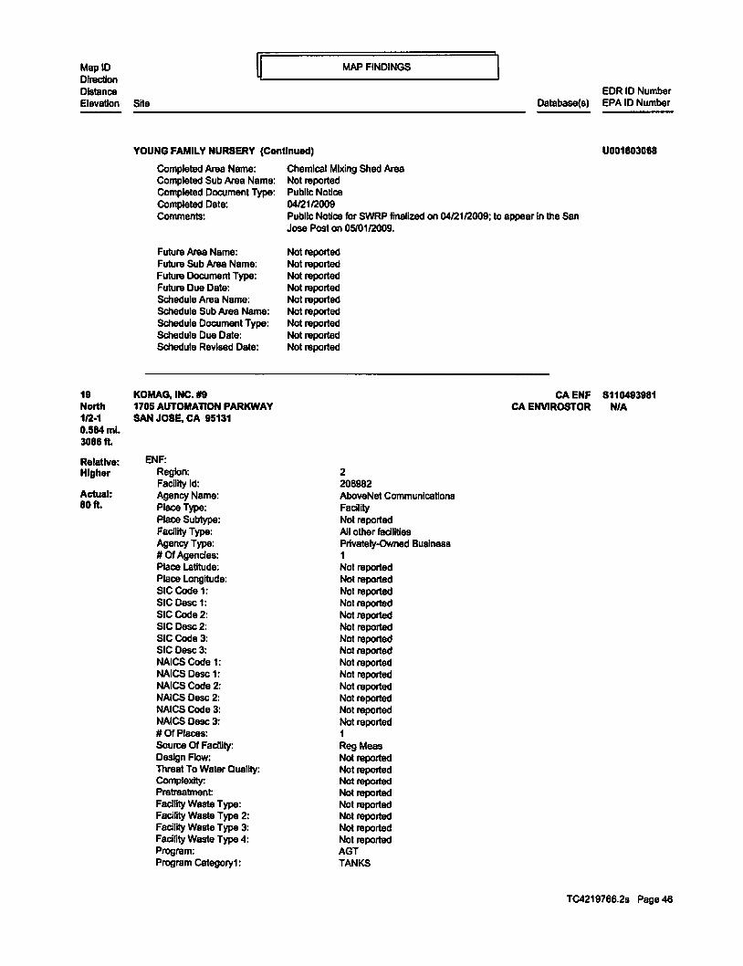
MAP FINDINGS MapiD ij Direction '---------------------J Distance EDR ID Number Elevation Site Database(&) EPA ID Number
YOUNG FAMILY NURSERY (Continued) U001803088
19 North 112·1 0.584ml. 3088 ft.
Rolatlve: Higher
Actual: 80ft.
Completed Area Name: Completed Sub Area Name: Completed Document Type: Completed Date: Comments:
Future Area Name: Future Sub Area Name: Future Document Type: Future Due Date: Schedule Area Name: Schedule Sub Area Name: Schedule Document Type: Schedule Due Date: Schedule Revised Date:
KOMAG,INC. #9 1705 AUTOMAnON PARKWAY SAN JOSE, CA 95131
ENF: Region: Facility ld: Agency Name: Place Type: Place Subtype: Facility Type: Agency Type: # Of Agencies: Place latitude: Place Longitude: SIC Code 1: SICDesc 1: SICCode2: SIC Desc2: SICCode3: SIC0esc3: NAICS Code 1: NAICS Oesc 1: NAICS Code 2: NAICS Desc 2: NAICS Code 3: NAICS Desc 3: #Of Places: Source Of FaciUty: Design Flow: Threat To Water Quality: Complexity: Pretreatment: FaciDty Waste Type: Facility Waste Type 2: Facility Waste Type 3: FaciHty Waste Type 4: Program: Program Cstegory1:
Chemical Mixing Shed Area Not reported Public Notice 0412112009 Public Notice for SWRP finalized on 0412112009; to appear in the San Jose Post on 05/0112009.
Not reported Not reported Not reported Not reported Not reported Not reported Not reported Not reported Not reported
2 206982 AboveNet Communications Facility Not reported All other facilities Privately-Owned Business 1 Not reported Not reported Not reported Not reported Not reported Not reported Not reported Not reported Not reported Not reported Not reported Not reported Not reported Not reported 1 Reg Meas Not reported Not reported Not reported Not reported Not reported Not reported Not reported Not reported AGT TANKS
CA ENF 8110493981 CA ENVIROSTOR NIA
TC4219766.2s Page 46

MapiD Direction Distance Elevation Site
KOMAG, INC. IJ9 (Continued)
Program C8tegory2: # Of Programs: WOlD: Reg Measwe ld: Reg Measure Type: Region: Order#: Npdes#CA#: Major-Minor: Npdes Type: Reclamation: Dredge Fill Fee: 30tH: Application Fee Amt Received: Status: Status Date: Effective Date: Expiration/Review Date: Tennlnalion Date: WOR Review- Amend: WDR Review- Revise/Renew: WDR Review - Rescind: WOR Review- No Action Required: WOR Review- Pending: WDR Review· Planned: Status Enrollee: lndlvlduaUGeneral: Fee Code: DlrectionNoice: Enforcement ld(EIO): Region: Order I Resolution Number. Enforcement Action Type: Effective Date: Adoption/Issuance Date: Achieve Date: Tenninallon Data: ACL Issuance Date: EPL Issuance Date: Status: Title: Description:
Program: Latest Milestone Completion Date: # Of Programst: Total Assessment Amount: Initial Assessed Amount: Liability $ Amount: Project $ Amount: LlabiUty $ Paid: ProJect $ Completed: Total $ Paid/Completed Amount
ENVIROSTOR: Facility ID: 71003440
MAP FINDINGS
EDR ID Number Database(&) EPA ID Number
TANKS 1 243AGT440U 169539 Unregulated 2 Not reported Not reported Not reported Not reported Not reported Not reported Not reported Not reported Never Active 02120/2013 Not reported Not reported Not reported Not reported Not reported Not reported Not reported Not reported Not reported N I Not reported Passive 241463 2 UNKNOWN Staff Enforcement Letter 04/30/2002 Not reported Not reported Not reported Not reported Not reported Historical Enforcement· 2 43AGT440U Notice of Noncompliance with APSA Facility has been contacted AGT Not reported 1 $0.00 $0.00 $0.00 $0.00 $0.00 $0.00 $0.00
8110493981
Status: Inactive • Needs Evaluation
TC4219766.2s Page 47

MapiD Direction Distance Elevation Site
MAP FINDINGS
EDR ID Number Database(&) EPA ID Number ------------------------------------------------
20 NNW 112·1 0.664ml. 3508ft.
Relative: Lower
Actual: 70ft.
KOMAG, INC. il9 (Continued)
Status Date: Site Code: Site Type: Site Type Detailed: Acres: NPL: Regulatoty Agencies: Lead Agency: Program Manager: Supervisor: Division Branch: Assembly: Senate: Special Program: Restricted Use: Site Mgmt Req: Funding: Latitude: Longitude: APN: Past Use: Potential COC: Conflnned COC: Potential Description: Alias Name: Alias Type: Alias Name: AllasType:
Completed Info: Completed Area Name:
Not reported Not reported Tiered Pennlt Tiered Penni! Not reported NO NONE SPECIFIED NONE SPECIFIED Not reported Not reported Cleanup Berkeley 25 10 Not reported NO NONE SPECIFIED Not reported 37.39032 -121.8849 NONE SPECIFIED NONE SPECIFIED NONE SPECIFIED NONE SPECIFIED NONE SPECIFIED
CAR000008573 EPA Identification Number 71003440 Envlrostor ID Number
Completed Sub Area Name: Not reported Not reported Not reported Not reported Not reported
Completed Document Type: Completed Date: Comments:
Future Area Name: Future Sub Area Name: Future Document Type: Future Due Date: Schedule Area Name: Schedule Sub Area Name: Schedule Document Type: Schedule Due Date: Schedule Revised Date:
ABOVENET COMMUNICATIONS 1735 LUNDY AVENUE SAN JOSE, CA 95131
RCRA-SQG:
Not reported Not reported Not reported Not reported Not reported Not reported Not reported Not reported Not reported
Date fonn received by agency: 10/1212000 Facility name: ABOVENET COMMUNICATIONS Site name: KOMAG, INC. BUILDING 6 Facility address: 1735 LUNDY AVENUE
SAN JOSE, CA 95131
8110493981
RCRA.SQG 1000145956 CA CUPA Listings CAD982403792
CA SAN JOSE HAZMAT CAEMI
CA ENVIROSTOR
TC4219766.2s Page 48

MapiD Direction Distance
ijL __________ MAP ____ FI_N_DI_N_G_s __________ ~
Elevation Site EDR ID Number
Dalabase(s) EPA ID Number
ABOVENET COMMUNICATIONS (ConUnued) 1000145956
EPA ID: CAD982403792 Mailing address: 1710AUTOMATION PARKWAY
SAN JOSE, CA 95131 Contact: BLAIR MICHAEL Contact address: Not reported
Not reported Contact country: US Contact telephone: (408) 576-2113 Contact email: Not reported EPA Region: 09 Land type: Private Classification: Small Small Quantity Generator Description: Handler: generates more than 100 and less than 1000 kg of hazardous
waste during any calendar month and accumulates less than 6000 kg of hazardous waste at any time; or generates 100 kg or less of hazardous waste during any calendar month, and accumulates more than 1000 kg of hazardous waste at any time
Handler Activities Summary: U.S. importer of hazardous waste: No Mixed waste (haz. and radioactive): No Recycler of hazardous waste: No Transporter of hazardous waste: No Treater, starer or disposer of HW: No Underground Injection activity: No On-site bumer exemption: No Furnace exemption: No Used oil fuel bumer: No Used oil processor: No User oil refiner: No Used oil fuel marketer to bumer: No Used oil Specification marketer: No Used oil transfer facility: No Used oil transporter: No
Historical Generators: Date form received by agency:04/1012000 Site name: ABOVENET COMMUNICATIONS Classification: Small Quantity Generator
Date form received by agency: 03104/1999 Site name: KOMAG, INC. BUILDING 6 Classification: Large Quantity Generator
Date form received by agency:09101/1996 Site name: ABOVENET COMMUNICATIONS Classification: Large Quantity Generator
Dale form received by agency:03126/1996 Site name: KOMAG, INC BLDG 6 Classification: Large Quantity Generator
Date form received by agency: 0313111994 Site name: KOMAG, INC Classification: Large Quantity Generator
TC4219766.2s Page 49

MapiD Direction Distance
~~----------M_AP ___ FI_N_DI_N_G_s __________ ~ EDR ID Numbar
Elevation Site Database(s) EPA ID Numbar
ABOVENET COMMUNICATIONS (Continued) 1000145956
Hazardous Waste Summery: Waste code: 0001 Waste name: IGNITABLE HAZARDOUS WASTES ARE THOSE WASTES WHICH HAVE A FLASHPOINT OF
LESS THAN 140 DEGREES FAHRENHEIT AS DETERMINED BY A PENSKY·MARTENS CLOSED CUP FLASH POINT TESTER. ANOTHER METHOD OF DETERMINING THE FLASH POINT OF A WASTE IS TO REVIEW THE MATERIAL SAFETY DATA SHEET. WHICH CAN BE OBTAINED FROM THE MANUFACTURER OR DISTRIBUTOR OF THE MATERIAL. LACQUER THINNER IS AN EXAMPLE OF A COMMONLY USED SOLVENT WHICH WOULD BE CONSIDERED AS IGNITABLE HAZARDOUS WASTE.
Waste code: D002 Waste name: A WASTE WHICH HAS A PH OF LESS THAN 2 OR GREATER THAN 12.5 IS
CONSIDERED TO BE A CORROSIVE HAZARDOUS WASTE. SODIUM HYDROXIDE, A CAUSTIC SOLUTION WITH A HIGH PH, IS OFTEN USED BY INDUSTRIES TO CLEAN OR DEGREASE PARTS. HYDROCHLORIC ACID, A SOLUTION WITH A LOW PH, IS USED BY MANY INDUSTRIES TO CLEAN METAL PARTS PRIOR TO PAINTING. WHEN THESE CAUSTIC OR ACID SOLUTIONS BECOME CONTAMINATED AND MUST BE DISPOSED. THE WASTE WOULD BE A CORROSIVE HAZARDOUS WASTE.
Facility Has Recelvad Notices of VIOlations: Regulation violated: FR- 262.1Q-12.A Area of violation: Generators - General Date violation determined: 0310811995 Date achieved compDance: 0310812000 VIolation lead agency: State
Enforcement action: Not reported Enforcement action date: Not reported Enf. disposition status: Not reported Enf. disp. status date: Not reported Enforcement lead agency: Not reported Proposed penalty amount: Not reported Anal penalty amount: Not reported Paid penalty amount: Not reported
Regulation violated: Area of violation: Date violation datarmlned: Date achieved compliance: VIolation lead agency:
Enforcement action: Enforcement action date: Enf. disposition status: Enf. dlsp. status date: Enforcement lead agency: Proposed penalty amount: Final penalty amount: Paid penalty amount:
Evaluation Action Summary: Evaluation date: Evaluation: Area of violation: Date achieved compliance: Evaluation lead agency:
Evaluation date:
FR • 262.1Q-12.A Generators • General 08124/1993 09126/1993 State Not reported Not reported Not reported Not reported Not reported Not reported Not reported Not reported
03106/1995 COMPLIANCE EVALUATION INSPECTION ON-SITE Generators - General 03/0812000 State Contractor/Grantee
0812411993
TC4219766.2s Page 50

MapiD Direction Distance
MAP FINDINGS
Elevation Site
ABOVENET COMMUNICATIONS (Continued)
Evaluation: Area of violation:
COMPLIANCE EVALUATION INSPECTION ON-SITE Generators - General
Date achieved compliance: 09128/1993 Evaluation lead agency: State Contractor/Grantee
CUPA SANTA CLARA: Region: PE#:
SANTA CLARA 2399
Program Description: UNDERGROUND STORAGE TANK PROGRAM RECORD
Region: PE#:
SANTA CLARA BP01
Program Desaiptlon: HMBP FACILITY, 1-3 CHEMICALS
Region: SANTA CLARA PE#: 2202 Program Description: GENERATES< 100 KGIYR
SAN JOSE HAZMAT: Region: SAN JOSE File Num: 406598 Class: Misc. Complex flnns and labs
EM I: Year: County Code: Air Basin: Facility ID: Air District Name: SIC Code: Air District Name: Community Health Air Pollution Info System: Consolidated Emission Reporting Rule: Total Organic Hydrocarbon Gases Tons/Yr. Reactive Organic Gases Tons/Yr. Carbon Monoxide Emissions Tons/Yr. NOX- Oxides of Nitrogen Tons/Yr. SOX- Oxides of Sulphur Tons/Yr. Particulate Matter Tons/Yr. Part. Matter 10 Micrometers & Smllr Tons/Yr.
Year: County Code: Air Basin: Facility ID: Air District Name: SIC Code: Air District Name: Community Health Air Pollution Info System: Consolidated Emission Reporting Rule: Total Organic Hydrocarbon Gases Tons/Yr. Reactive Organic Gases Tons/Yr: Carbon Monoxide Emissions Tons/Yr: NOX- Oxides of Nitrogen Tons/Yr. SOX- Oxides of Sulphur Tons/Yr. Particulate Matter Tons/Yr. Part. Matter 10 Micrometers & SmHr Tons/Yr.
1990 43 SF 5441 BA 3674 BAY AREA AQMD Not reported Not reported 15 7 0 0 0 0 0
1993 43 SF 5441 BA 3674 BAY AREA AQMO Not reported Not reported 19 14 0 0 0 0 0
EOR 10 Number Oatabase(s) EPA 10 Number
1000145956
TC4219766.2s Page 51

MapiD Direction Distance
MAP FINDINGS
Elevation Site
ABOVENET COMMUNICAnONS (Continued)
Year: County Code: Air Basin: Facifrty ID: Air District Name: SIC Code: Air District Name: Community Health Air Pollution Info System: Consolidated Emission Repofting Rule: Total Organic Hydrocarbon Gases Tons/Yr: Reactive Organic Gases Tons/Yr: Carbon Monoxide Emissions Tons/Yr. NOX ·Oxides of Nitrogen Tons/Yr: SOX- Oxides of Sulphur Tons/Yr: Particulate Matter Tons/Yr: Part. Matter 10 Micrometers & Smllr Tons/Yr:
Year: County Code: A1r Basin: Facifrty ID: Air District Name: SIC Code: Air District Name: Community Health Air Pollution Info System: Consolidated Emission Reporting Rule: Total Organic Hydrocarbon Gases Tons/Yr. Reactive Organic Gases TonsiYr: Carbon Monoxide Emissions Tons/Yr. NOX- Oxides of Nitrogen Tons/Yr. SOX· OXIdes of Sulphur Tons/Yr: Particulate Matter Tons/Yr. Part. Matter 10 Micrometers & SmllrTons/Yr.
Year. County Code: Air Basin: Facility ID: Air District Name: SIC Code: Air District Nama: Community Health Air Pollution Info System: Consolidated Emission Reporting Rule: Total Organic Hydrocarbon Gases Tons/Yr. Reactive Organic Gases Tons/Yr: Csrbon Monoxide Emissions Tons/Yr: NOX- OXIdes of Nitrogen TonsiYr: SOX- Oxides of Sulphur Tons/Yr. Particulate Matter Tons/Yr. Part Matter 10 Micrometers & Smllr Tons/Yr.
Year: County Code: A1rBasln: FaciHtyiD: Ajr District Name: SIC Code:
1995 43 SF 5441 BA 3674 BAY AREA AQMD Not reported Not reported 66 44 0 0 0 0 0
1996 43 SF 5441 BA 3674 BAYAREAAQMD Not reported Not reported 66 44 0 0 0 0 0
1997 43 SF 5441 BA 3674 BAY AREA AQMD Not reported Not reported 13 9 0 0 0 0 0
1998 43 SF 5441 BA 3674
EDR ID Number Database(s) EPA ID Number
1000145956
TC4219766.2s Page 52

MapiD Direction Distance
~~----------M_A_P __ FI_N_DI_N_G_s __________ ~ Elevation Site ------------------------------------------------
ABOVENET COMMUNICAnONS (Continued)
Alr District Name: Community Health Air Pollution Info System: Consolidated Emission Reporting Rule: Total Organic Hydrocarbon Gases Tons/Yr: Reactive Organic Gases Tons/Yr: Carbon Monoxide Emissions Tons/Yr. NOX ·Oxides of Nitrogen Tons/Yr. SOX· Oxldas of Sulphur Tons/Yr: Particulate Matter Tons/Yr. Part. Matter 10 Micrometers & Smllr Tons/Yr.
Year: County Code: Air Basin: Facility ID: Alr District Name: SIC Code: Air District Name: Community Health Air Pollution Info System: Consolidated Emission Reporting Rule: Total Organic Hydrocarbon Gases Tons/Yr. Reactive Organic Gases Tons/Yr. Carbon Monoxide Emissions Tons/Yr: NOX ·Oxides of Nitrogen Tons/Yr: SOX· Oxides of Sulphur Tons/Yr. Particulate Matter Tons/Yr. Part. Matter 10 Micrometers & Smllr Tons/Yr.
Year: County Code: Air Basin: Facility ID: Alr District Name: SIC Code: Air District Name: Community Health Alr Pollution Info System: Consolidated Emission Reporting Rule: Total Organic Hydrocarbon Gases Tons/Yr: Reactive Organic Gases Tons/Yr. Carbon Monoxide Emissions Tons/Yr: NOX ·Oxides of Nitrogen Tons/Yr. SOX· Oxides of Sulphur Tons/Yr: Particulate Matter Tons/Yr: Part. Matter 10 Micrometers & Smllr Tons/Yr.
ENVIROSTOR: Facility ID: 71003023
BAY AREA AQMD Not reported Not reported 17 10 0 1 0 0 0
1999 43 SF 5441 BA 3695 BAY AREA AQMD Not reported Not reported 16 15 0 0 0 0 0
2000 43 SF 5441 BA 3695 BAY AREAAQMD Not reported Not reported 16 15 0 0 0 0 0
Status: Status Date:
Inactive • Needs Evaluation Not reported
Site Code: Site Type: Site Type Detailed: Acres: NPL: Regulatory Agencies: Lead Agency: Program Manager:
Not reported Tiered Permit Tiered Pennit Not reported NO NONE SPECIFIED NONE SPECIFIED Not reported
EDR ID Number Database(&) EPA ID Number
1000145958
TC4219766.2s Page 53

MapiD Direction Distance
~L __________ M_A_P __ FI_N_DI_N_G_s __________ ~ EDR 10 Number
Elavation Site Database(s) EPA 10 Number
21 North 112-1 0.741 mi. 3912 ft.
Relative: Higher
Actual: 80ft.
------------------------------------------------ABOVENET COMMUNICAnONS (Continued)
Supervisor: Division Branch: Assembly: Senate: Special Program: Restricted Use: Site Mgmt Req: Funding: Latitude: Longitude: APN: Past Use: Potential CCC: Conflnned CCC: Potential Description:
Not reported Cleanup Berkeley 25 10 Not reported NO NONE SPECIFIED Not reported 37.38879 -121.8873 NONE SPECIFIED NONE SPECIFIED NONE SPECIFIED NONE SPECIFIED NONE SPECIFIED
Alias Name: CAD982403792 Alias Type: Alias Name: Alias Type: Alias Name: Alias Type:
Completed Info: Completed Area Name: Completed Sub Area Name: Completed Document Type: Completed Date: Comments:
Future Area Name: Future Sub Area Name: Future Document Type: Future Due Date: Schedule Area Name: Schedule Sub Area Name: Schedule Document Type: Schedule Due Date: Schedule Revised Date:
WDMEDIALLC 1710 AUTOMATION PY SAN JOSE, CA 95131
NPDES: Npdes Number: Facility Status: Agencyld: Region: Regulatory Measure ld: Order No: Regulatory Measure Type: Place ld: WOlD: Program Type:
EPA Identification Number 110000747416 EPA(FRS#) 71003023 Enviroator 10 Number
Not reported Not reported Not reported Not reported Not reported
Not reported Not reported Not reported Not reported Not reported Not reported Not reported Not reported Not reported
CAS000001 Active 0 2 184088 97-D3-DWQ Enrollee
Adoption Date Of Regulatory Measure:
Not reported 2431012570 Industrial Not reported 09/18/1998 Effective Date Of Regulatory Measure:
1000145956
CA NPDES 8110493980 CA CUPA Listings NJA
CA SAN JOSE HAZMAT CA ENVIROSTOR
TC4219766.2s Page 54

MapiD Direction Distance
ij~ _________ M_A_P_F_I_ND_I_N_G_s __________ ~ Elevation Site
WD MEDIA LLC (Continued)
Expiration Date Of Regulatory Measure: Not reported Not reported WDMedia Inc
Tennination Date Of Regulatory Measure: Discharge Name: Discharge Address: Discharge City: Discharge State: Discharge Zip:
CUPA SANTA CLARA: Region: PE#: Program Description:
Region: PE#: Program Description:
Region: PE#: Program Description:
SAN JOSE HAZMAT:
1710 Automation Pkwy San Jose California 95131
SANTA CLARA BP06 HMBP FACILITY, 22+ CHEMICALS
SANTA CLARA 2206 GENERATES 5 TO <25 TONS/YR
SANTA CLARA 2261 PERMIT BY RULE (PBR)
Region: SAN JOSE File Num: 407555 Class: Misc. Complex tlnns and labs
ENVIROSTOR: FacilityiD: Status: Status Date: Site Code: Site Type: Site Type Detailed: Acres: NPL: Regulatory Agencies: lead Agency: Program Manager: Supervisor: Division Branch: Assembly: Senate: Special Program: Restricted Use: Site Mgmt Req: Funding: latitude: Longitude: APN: Past Use: Potential COC: Confinned COC: Potential Description: Alias Name: Alias Type: Alias Name:
71003455 Inactive - Needs Evaluation Not reported Not reported Tiered Pennit Tiered Pennlt Not reported NO NONE SPECIFIED NONE SPECIFIED Not reported Not reported Cleanup Bert<eley 25 10 Not reported NO NONE SPECIFIED Not reported 37.39199 -121.8836 NONE SPECIFIED NONE SPECIFIED NONE SPECIFIED NONE SPECIFIED NONE SPECIFIED
CAR000013581 EPA Identification Number 71003455
EDR ID Number Database(s) EPA ID Number
8110493980
TC4219766.2s Page 55

MapiD Direction Distance
~~----------MA __ P_F_I_ND_I_N_G_s __________ _j
Elevation Site
22 NW 112·1 0.760ml. 4014ft.
Relative: Lower
Actual: 58ft.
WD MEDIA LLC (Continued)
Alias Type: Envlrostor ID Number
Completed Info: Completed Area Name: Completed Sub Area Name: Completed Document Type: Completed Date: Comments:
Future Area Name: Future Sub Area Name: Future Document Type: Future Due Date: Schedule Area Name: Schedule Sub Area Name: Schedule Document Type: Schedule Due Date: Schedule Revised Date:
QUANTUM CLEAN 1712 RINGWOOD AVE. SAN JOSE, CA 95131
EM I: Year: County Code: AJr Basin: Facility ID: AJr District Name: SIC Code: Alr District Name:
Not reported Not reported Not reported Not reported Not reported
Not reported Not reported Not reported Not reported Not reported Not reported Not reported Not reported Not reported
Convnunlty Health Air Pollution Info System: Consolidated Emission Reporting Rule: Total Organic Hydrocarbon Gases Tons/Yr. Reactive Organic Gases Tons/Yr. Carbon Monoxide Emissions Tons/Yr: NOX- Oxides of Nitrogen Tons/Yr. SOX· Oxides of Sulphur Tons/Yr: Particulate Matter Tons/Yr: Part. Matter 10 Miaometers & SmllrTonsiYr:
Year: County Code: Air Basin: FaciUty ID: Alr District Name: SIC Code: AJr District Name: Community Health Air Pollution Info System: Consolidated Emission Reporting Rule: Total Organic Hydrocarbon Gases Tons/Yr: Reactive Organic Gases Tons/Yr: Carbon Monoxide Emissions Tons/Yr: NOX- Oxides of Nitrogen Tona/Yr: SOX - Oxides of Sulphur TonaiYr: Particulate Matter Tona/Yr:
2008 43 SF 18504 BA 3471 BAY AREA AOMD Not reported Not reported 0 0 0 0 0 0 0
2009 43 SF 18504 BA 3471 BAY AREAAQMD Not reported Not reported 0 0 0 0 0 0
EDR ID Number Database(s) EPA ID Number
8110493880
CA EMI 8110503158 CA ENVIROSTOR NIA
TC4219766.2s Page 58

MapiD Direction Distance
~~-----------MAP--_FI_N_DI_N_G_s __________ ~ Elevation Site ------------------------------------------------
QUANTUM CLEAN (Continued)
Part. Matter 10 Micrometers & Smllr Tons/Yr. 0
Year: County Code: Air Basin: Facility ID: Air District Name: SIC Code: Air District Name: Community Health Air Pollution Info System: Consolidated Emission Repof1lng Rule: Total Organic Hydrocarbon Gases Tons/Yr. Reactive Organic Gases Tons/Vr: carbon Monoxide Emissions Tons/Yr. NOX- Oxides of Nitrogen Tons/Vr: SOX- Oxides of Sulphur Tons/Vr: Particulate Matter Tons/Vr: Part. Matter 10 Micrometers & Smllr Tons/Yr.
Year: County Code: Air Basin: Facility ID: Air District Name: SIC Code: Air District Name: Community Health Air Pollution Info System: Consolidated Emission Reporting Rule: Total Organic Hydrocarbon Gases Tons/Vr: Reactive Organic Gases Tons/Vr: carbon Monoxide Emissions Tons/Vr: NOX ·Oxides of Nitrogen Tons/Vr: SOX- Oxides of Sulphur Tons/Yr. Particulate Matter Tons/Vr: Part. Matter 10 Micrometers & SmllrTons/Vr:
Year: County Code: Air Basin: FacilltyiD: Air District Name: SIC Code: Air District Name: Community Health Air Pollution Info System: Consolidated Emission Reporting Rule: Total Organic Hydrocarbon Gases Tons/Yr. Reactive Organic Gases Tons/Yr. carbon Monoxide Emissions Tons/Yr. NOX- Oxides of Nitrogen Tons/Yr. SOX- Oxides of Sulphur Tons/Yr: Particulate Matter Tons/Vr: Part. Matter 10 Micrometers & Smllr Tons/Yr.
ENVIROSTOR: Facility ID: 71004103
2010 43 SF 18504 BA 3471 BAY AREA AQMD Not reported Not reported 0 0 0 0 0 0 0
2011 43 SF 18504 BA 3471 BAY AREA AQMD Not reported Not reported 0 0 0 0 0 0 0
2012 43 SF 18504 BA 3471 BAY AREAAQMD Not reported Not reported 0 0 0 0 0 0 0
Status: Status Date:
Inactive • Needs Evaluation 0911612013
EDR ID Number Database(s) EPA ID Number
8110503158
TC4219766.2s Page 57

MapiD Direction Distance
ij~----------MAP--__ FI_N_DI_N_G_s __________ ~ Elevation Site
QUANTUM CLEAN (Continued)
Site Code: Site Type: Site Type Detailed: Acres: NPL: Regulatory Agencies: Lead Agency: Program Manager: Supervisor: Division Branch: Assembly: Senate: Special Program: Restricted Use: Site Mgmt Req: Funding: Latitude: Longitude: APN: Past Use: Potential COC: Confirmed COC: Potantial Description: Alias Name: Alias Type: Alias Name: Alias Type:
Completed Info: Completed Araa Name:
Not reported Tiered Pennit Tiered Pennit 0 NO NONE SPECIFIED NONE SPECIFIED Not reported Mark Piros Cleanup Berkeley 25 10 Not reported NO NONE SPECIFIED Not reported 37.38737 -121.8920 NONE SPECIFIED NONE SPECIFIED NONE SPECIFIED NONE SPECIFIED NONE SPECIFIED
CAL000308188 EPA Identification Number 71004103 Env!rostor ID Number
Completed Sub Area Name: Not reported Not reported Not reported Not reported Not reported
Completed Document Type: Completed Date: Comments:
Future Area Name: Future Sub Area Name: Future Document Type: Future Due Date: Schedule Area Name: Schedule Sub Area Name: Schedule Document Type: Schedule Due Date: Schedule Revised Date:
Not reported Not reported Not reported Not reported Not reported Not reported Not reported Not reported Not reported
EDR ID Number Database(&) EPA ID Number
8110503158
TC4219766.2s Page 58

MapiD Direction Dislllnce
~L----------MA __ P __ FI_N_DI_N_G_s __________ ~ EDR ID Number
Elevation Site Database(s) EPA ID Number
D23 South 112·1 0.788ml. 4044 ft.
RelatJve: Lower
Actual: 73ft.
------------------------------------------------CLEAN HARBORS SAN JOSE LLC 1021 BERRYESSA ROAD
RCRA·TSDF 1000430269 CERC-NFRAP CAD059494310
CORRACTS SAN JOSE. CA 95133
Site 1 of 2 In cluster D
RCRA-TSDF:
RCRA-LQG US ENG CONTROLS
US INST CONTROL ROD
FINDS CANPDES
CASUC CAHISTUST
CA SAN JOSE HAZMAT NY MANIFEST WI MANIFEST
CA ENVIROSTOR CAMWMP
CA Financial Assurance 2020 COR ACTION
CAHWP PRP
USFINASSUR
Date fonn received by agency:03/0112014 Facility name: Facility address:
EPAID: Mailing address:
Contact: Contact address:
Contact country: Contact telephone: Contact email: EPA Region: Land type: Classification: Description:
Classification: Description:
Otvner/Operator Summary: Owner/operator name: Owner/operator address:
CLEAN HARBORS SAN JOSE LLC 1021 BERRYESSA ROAD SAN JOSE, CA 95133 CAD059494310 BERRYESSA ROAD SAN JOSE, CA 95133 LON R STEWART BERRYESSA ROAD SAN JOSE, CA 95133 Not reported (408) 441-0962 [email protected] 09 Private TSDF Handler Is engaged In the treatment, storage or disposal of hazardous waste Large Quantity Generator Handler: generates 1 ,000 kg or more of hazardous waste during any calendar month; or generates more than 1 kg of acutely hazardous waste during any calendar month; or generates more than 100 kg of any residue or contaminated soil, waste or other debris resulting from the cleanup of a spill, Into or on any land or water, of acutely hazardous waste during any calendar month; or generates 1 kg or less of acutely hazardous waste during any calendar month, and accumulates more than 1 kg of acutely hazardous waste at any time; or generates 100 kg or less of any residue or contaminated soil, waste or other debris resulting from the cleanup of a spill, Into or on any land or water, of acutely hazardous waste during any calendar month, and acaJmulates more than 100 kg of that material at any time
CLEAN HARBORS SAN JOSE LLC BERRYESSA ROAD SAN JOSE, CA 95133
TC4219768.2s Page 59
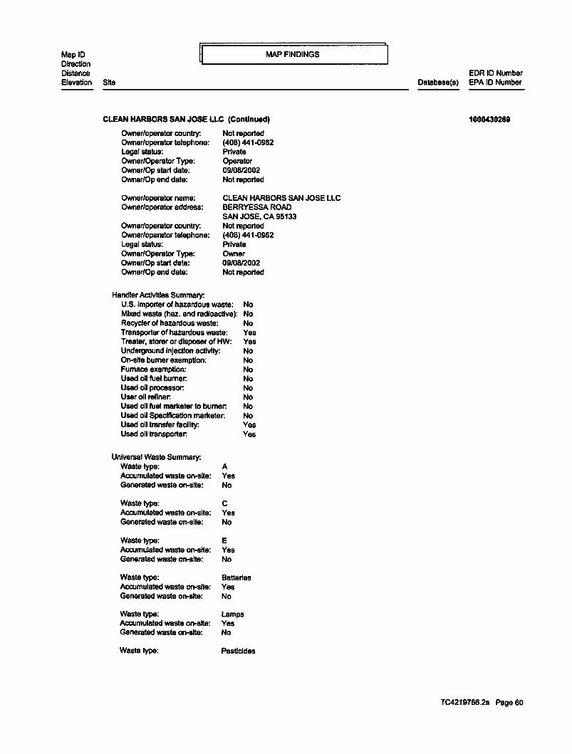
MapiD Direction Distance
MAP FINDINGS
Elevation SHe
CLEAN HARBORS SAN JOSE LLC (Continued)
Owner/operator country: Owner/operator telephone: Legal status: Owner/Operator Type: Owner/Op start date: Owner/Op end date:
Owner/operator name: Owner/operator eddi9SS:
Owner/operator country: Owner/operator telephone: Legal status: Owner/Operator Type: Owner/Op start date: Owner/Op end data:
Handler Actlvltles Summary:
Not raported (408) 441..()962 Private Operator 09/08/2002 Not raported
CLEAN HARBORS SAN JOSE LLC BERRYESSA ROAD SAN JOSE, CA 95133 Not raported (408) 441..()962 Private Owner 09/0812002 Not raported
U.S. Importer of hazardous waste: No Mixed waste (haz. and radioactive): No Recycler of hazardous wasta: No Transporter of hazardous waste: Yes Treater, storer or disposer of HW: Yes Underground injection activity: No On-sHe burner exemption: No Furnace exemption: No Used oil fuel burner: No Used oU processor: No User oil refiner: No Used oil fuel marketer to burner: No Used oil Specification mariteter: No Used oil transfer facility: Yes Used oil transporter: Yes
Universal Wasta Summary: Wasta type: Accumulated wasta on-site: Generated waste on-sHe:
Wasta type: Accumulated waste on-site: Generated waste on-site:
Waste type: Accumulated waste on-site: Generated waste on-site:
Wasta type: Accumulated waste on-site: Generated wasta on-site:
Waste type: Accumulated waste on-sHe: Generated wasta on-site:
Waste type:
A Yes No
c Yes No
E Yes No
Batteries Yes No
Lamps Yes No
Pesticides
EDR ID Number Database{&) EPA ID Number
1000430269
TC4219766.2s Page 60

MapiD Direction Distance
ij~-----------MAP---F-IN_D_IN_G_s __________ ~ Elevation Site
CLEAN HARBORS SAN JOSE LLC (Continued)
Accumulated waste on-site: Generated waste on-site:
Waste type: Accumulated waste on-site: Generated waste on-site:
Historical Generators:
Yes No
Thermostats Yes No
Date form received by agency: 10/1212012 Site name: CLEAN HARBORS SAN JOSE, LLC Classification: Large Quantity Generator
Data form received by agency:07/16/2010 Site nama: CLEAN HARBORS SAN JOSE, LLC Classification: Large Quantity Generator
Date form received by agency: 02128/2008 Site name: CLEAN HARBORS SAN JOSE LLC Classification: Large Quantity Generator
Date form received by agency: 0212412006 Site name: CLEAN HARBORS SAN JOSE LLC Classification: Large Quantity Generator
Date form received by agency: 0313012004 Site name: CLEAN HARBORS SAN JOSE LLC Classification: Large Quantity Generator
Date form received by agency: 12/0912002 Site name: CLEAN HARBORS SAN JOSE LLC Classification: Large Quantity Generator
Date form received by agency: 02/2812002 Site nama: SAFETY-KLEEN (SAN JOSE) INC Classification: Large Quantity Generator
Date form received by agency: 10/1212000 Site name: SAFETY-KLEEN (SAN JOSE). INC. Classification: Large Quantity Generator
Date form received by agency: 01/0512000 Site nama: SAFETY KLEEN SAN JOSE INC Classification: Not a generator, verified
Date form received by agency:06/06/1999 Site name: LAIDLAW ENVIRONMENTAL SERV. (SAN JOSE) Classification: Large Quantity Generator
Date form received by agency:07/01/1997 Site name: SAFETY KLEEN SAN JOSE INC Classification: Not a generator, verified
Date form received by agency: 09/0111996 Site nama: SAFETY KLEEN SAN JOSE INC Classification: Large Quantity Genllf'8tor
Date form received by agency:02129/1996
EDR ID Number Database(s) EPA ID Number
1000430269
TC4219766.2s Page 61

MapiD Direction Distance
~~----------MA __ P_F_I_ND_I_N_G_s __________ ~ Elevation Site
EDR ID Number Database(s) EPA ID Number
CLEAN HARBORS SAN JOSE LLC {Continued) 1000430269
Site name: Classification:
SOLVENT SERVICE CO INC Large Quantity Generator
Date form received by agency:03130/1994 Site nama: TRS ·SAN JOSE; SOLVENT SERVICE CO., INC Classification: Large Quantity Generator
Date form received by agency:03131/1992 Site name: SOLVENT SERVICE CO., INC. Classification: Large Quantity Generator
Date form received by agency:05/11/1990 Site name: SOL VENT SERVICE INC Classification: Large Quantity Generator
Hazardous Waste Summary: Wasta coda: Waste name:
Waste code: Waste name:
Waste code: Waste name:
Waste code: Waste nama:
Waste code: Waste name:
Waste code: Waste name:
Waste code: Waste name:
Waste code: Waste name:
Waste code: Waste name:
Waste code: Waste name:
Waste code: Waste nama:
Waste code:
KOB6 SOLVENT WASHES AND SLUDGES, CAUSTIC WASHES AND SLUDGES, OR WATER WASHES AND SLUDGES FROM CLEANING TUBS AND EQUIPMENT USED IN THE FORMULATION OF INK FROM PIGMENTS, DRIERS, SOAPS, AND STABILIZERS CONTAINING CHROMIUM AND LEAD.
K087 DECANTER TANK TAR SLUDGE FROM COKING OPERATIONS
K088 SPENT POTLINERS FROM PRIMARY ALUMINUM REDUCTION
K090 EMISSION CONTROL DUST OR SLUDGE FROM FERROCHROMIUMSILICON PRODUCTION
K091 EMISSION CONTROL DUST OR SLUDGE FROM FERROCHROMIUM PRODUCTION
K093 DISTILLATION LIGHT ENDS FROM THE PRODUCTION OF PHTHALIC ANHYDRIDE FROM ORTHO-XYLENE
K094 DISTILLATION BOTTOMS FROM THE PRODUCTION OF PHTHALIC ANHYDRIDE FROM ORTHO-XYLENE
K095 DISTILLATION BOTTOMS FROM THE PRODUCTION OF 1,1,1-TRICHLOROETHANE
K096 HEAVY ENDS FROM THE HEAVY ENDS COLUMN FROM THE PRODUCTION OF 1,1,1· TRICHLOROETHANE.
K097 VACUUM STRIPPER DISCHARGE FROM THE CHLORDANE CHLORINATOR IN THE PRODUCTION OF CHLORDANE.
K098 UNTREATED PROCESS WASTEWATER FROM THE PRODUCTION OF TOXAPHENE
K099
TC4219766.2s Page 62

APPENDIX C
PHASE II ENVIRONMENTAL SITE ASSESSMENT REPORT


PHASE 1 ASSESSMENTS.C:OM PROVIDING ENVIRONMENTAL CONSULTING FOR YOUR BUSINESS
PHASE II ENVIRONMENTAL SITE ASSESSMENT REPORT
FOR ARAUJO RESIDENTIAL PROJECT
ARAUJO STREET SAN JOSE, SANTA CLARA COUNTY,
CALIFORNIA
OCTOBER 5, 2015
PREPARED FOR: KELSEY STEFFEN,
ENVIRONMENTAL PLANNER CITY OF SAN JOSE
200 E. SANTA CLARA STREET SAN JOSE, CALIFORNIA 95113
PREPARED BY: FARSHAD VAKILI, P.E.
273 CANYON FALLS DRIVE FOLSOM, CALIFORNIA 95630
173 Canyon Fnll• Drive
~lsom. CA 95630 Unircd States of Amenca
(916) 804·6232 (9 16} 988·66J9
ph~lasscssments.com

Phase II Environmental Site Assessment Report Araujo Residential Project, Araujo Street, San Jose, California
TABLE OF CONTENTS
1. INTRODUCTION ..... ...... .. .. ........ ....................................................................... 3
2. SCOPE OF WORK ........... .......................................... .. ...... ............ .... .............. 4
3. SITE OVERVIEW ........ ........... .................. ..... .... ... ........... ................................. 5
4. ENVIRONMENTAL SETTING ............................................................................ 6
5. FIELD ACTIVITY/BORING LOG .................................................... ... ........... ....... 7
6. LABORATORY ANAL YSIS ................................................ ...... ...... ... ................ 8
7. ANALYTICAL RESULTS ................................................................................... 9
8. CONCLUSION/RECOMMENDATION ...................................................... .......... 17
ATTAC HMENTS
2

Phase II Environmental Site Assessment Report Araujo Residential Project, Araujo Street, San Jose, California
1. INTRODUCTION
This document presents the results of a Phase II Environmental Site Assessment Report {Phase II) performed by Farshad Vakili, P.E., at the vacant residential land located at Araujo Street in San Jose, Santa Clara County, California {Subject Property). This document is in compliance with a Phase II Environmental Site Assessment Report (Report) Scope of Work. Please see Attachment 1 for a copy of the Scope of Work. The purpose of this Report is to collect eight soil samples at different depths including 1/2 and 1 1/2 feet below ground surface (bgs) at the different areas to determine any impacts from past time usages of the land for agricultural products and/or golf course.
3

Phase II Environmental Site Assessment Report Araujo Residential Project, Araujo Street, San Jose, California
2. SCOPE OF WORK (SOW)
As the result of the comments received from the City of San Jose Environment Review Program, the Scope of Work was prepared and to the City of San Jose for approval. SOW was finally approved by Ms. Kelsey Steffen of the City of San Jose. Please see Attachment 1 for the approved Scope of Work and Attachment 2 for the schematic diagram for the boring locations.
The following are the Scope of Work approved for the Phase II Environmental Site Assessment at Araujo Street in San Jose, Santa Clara County, California.
The City of San Jose requested additional investigation at the Araujo Residential Project. The City's Environmental Services Department provided the following comments on the SOW:
1. "The City of San Jose stated that the pesticides are commonly found in the upper two feet of soil. When we do this work in-house for a City property we typically collect samples from 6 to 12 inches below ground surface unless we have reason to believe fill was brought onto the site after the pesticide application. If contamination if found we then go back and collect deeper samples 2 to 2.5 feet. Some consultants will collect samples at several intervals, e.g. 6 to 12 inches, 2 to 2.5 feet and occasionally 4 to 4.5 feet below ground surface in one field trip and then analyze the upper 6 to 12 inches and put a hold on the deeper samples. It the shallow samples show contamination they then have the lab analyze the deeper samples".
2. "There is no objection to the consultant drilling borings to 5 feet and collecting (and analyzing) samples at different depths, but they need to test the shallow interval (6 to 12 inches) where the highest levels of pesticides are likely to be present and where the greatest exposure to construction workers and future residents would likely occur".
3. Please see the approved SOW in the Attachment 1.
4. A detailed site figure identifying all addresses and all boring locations is in the Attachment 2.
4

Phase II Environmental Site Assessment Report Araujo Residential Project, Araujo Street, San Jose, California
3. SITE OVERVIEW
The Subject Property is an approximately 25,000 square feet of a vacant land. This parcel of land has recently separated from the 1 00-acre San Jose Municipal Golf Course at 1560 Oakland Road in San Jose.
The land referred to herein is situated in the State of California, County of Santa Clara, City of San Jose and described as follows:
All that certain real property situated in the City of San Jose, County of Santa Clara, State of California, being a Portion of Parcel No. 5 as shown on the Record of Survey filed for Record in Book 220 of Maps, at Page 8-11, Records of Santa Clara County. The Santa Clara Assessor's Parcel Number is APN: 241-02-016 (Portion).
5

Phase II Environmental Site Assessment Report Araujo Residential Project, Araujo Street, San Jose, California
4. ENVIRONMENTAL SETTING
The Subject Property is located in the City of San Jose, Santa Clara County. The Hayward fault is one of the most hazardous faults in the United States, because of its high slip rate, its demonstrated ability to generate a large earthquake and, importantly, its location through the highly urbanized eastern San Francisco Bay area.
The underlying soil is an unconfined, low-permeability water-bearing zone that occurs from the ground surface to a depth to the groundwater. It consists primarily of fine grained sand and clay. The bottom of this area is defined by a clay layer, which is typically 6 to 16 feet thick, however this clay layer has been encountered to as much as 60 feet beneath the area. This clay layer serves as an aquitard and impedes flow.
Regional groundwater flow is westward toward San Francisco Bay, while local groundwater flow is toward the southwest. The groundwater depth is between 20-25 feet below ground surface.
6

Phase II Environmental Site Assessment Report Araujo Residential Project, Araujo Street, San Jose, California
5. FIELD ACTIVITY/BORING LOGS
On September 17, 2015, Mr. Vakili visited the Subject Property at 12:00 p.m., and met the crew from Cascade Drilling including Mr. Artemio Villegas and Mr. Jose Bridget. Cascade Drilling is located at 3000 Duluth Street in West Sacramento, California. Cascade Drilling Crew started the implementation of the approved Scope of Work which explained to them by Mr. Vakili. Cascade Drilling and Mr. Vakili reviewed the proposed Health & Safety Plan for the drilling procedure. Mr. Vakili started the site investigation pursuant to the approved Scope of Work. Mr. Vakili selected locations for per the SOW approved by the City of San Jose. Cascade Drilling started drilling at the marked locations at 12:30 p.m. on September 17, 2015.
All Boring and sampling were conducted in general accordance with approved ASTM Methods. The borings were advanced by using a hollow stem auger by manually turning continuous steel hollow-stem auger flights into the ground. At regular intervals, soil that encountered at the area included hardened silty clayey at about 1 to 12 inches bgs; underlain by more hardened silty clayey from 1 foot to 2 feet bgs. The soil samples were taken at 1/2 and 1 1/2 feet bgs at all the eight locations. The soil samples did not contain moisture at the time of the extraction.
The ambient air temperature was 85° F with 0 mph of wind at 12:00 p.m. Cascade Drilling started drilling at the designated locations at 12:30 p.m.
Mr. Vakili instructed the crew that he is taking soil samples from the eight locations at 1/2 foot and 1 1/2 feet bgs. Mr. Vakili completed taking the soil samples at 5:17 p.m. Representative portions of the soil samples obtained at the eight borings (Boring 1, 2, 3, 4, 5, 6, 7, and 8) were sealed in glass jars and transported to 273 Canyon Falls Drive in Folsom, California for the refrigerated storage. The samples were later transferred California Laboratory Services located at 3249 Fitzgerald Road in Rancho Cordova, California at 8:15a.m. on September 19, 2015. Please see Attachment 4 for all the soil sample analytical results. Please see the Photographs in Attachment 3.
7

Phase II Environmental Site Assessment Report Araujo Residential Project, Araujo Street, San Jose, Califomia
6. LABORATORY ANAYLSIS
Soil samples taken from the Subject Property were submitted to California Laboratory Services (CLS) located at 3249 Fitzgerald Road in Rancho Cordova, California. CLS is accredited by the State of California for all of the analysis performed at the laboratory. Soil samples were analyzed for chlorinated pesticide compounds in accordance with United States Environmental Protection Agency Method SW EPA 8081A and for CAM 17 Metals by EPA 60108. Please see the CLS Final Report in the Attachment 4.
Field and laboratory quality control (QC) procedures during sampling included the Following:
a. Disposable gloves were worn during all sampling procedures, and changed after each sample collection to prevent potential cross contamination;
b. Laboratory supplied soil sample glass jars were filled to achieve zero-head space and covered with teflon lined caps, labeled, and placed in a chilled, insulated cooler with frozen "blue ice" for delivery to the CLS;
c. Soil samples holding times and analysis was pursuant to the EPA Method guidelines;
d. Samples were labeled, logged on a Chain-of-Custody Form (CoC) and submitted to the laboratory accompanied by the CoC documentation;
e. Laboratory QC was performed pursuant to the procedures inherent with the specific methods used for analysis;
f. Analysis was performed by a laboratory certified by the State of California for each method of analysis used during the project.
8

Phase II Environmental Site Assessment Report Araujo Residential Project, Araujo Street. San Jose. California
7. ANALYTICAL RESULTS
Confirmation soil samples collected at the Subject Property were transported to CLS for analysis of the following components:
Chlorinated Pesticide Compounds by EPA 8081A CAM 17 Metals by EPA 60108
Soil Samples were analyzed for chlorinated pesticide compounds for all the soil samples and showed elevated levels for 4,4-DDE (dichlorodiphenyldichloroethylene), 4,4-DDT (dichlorodiphenyltrichloroethane), Chlordane-technical and Dieldrin. Please see Table 1 for the results.
Chlorinated Pesticides are nerve agents used in agriculture as pesticides, around homes as termiticides, and in grains as fungicides. These chemicals were designed to attack the nervous system of pests which leads to overstimulation of the nerves and eventually death. The most well-known chlorinated pesticide is DDT. Most chlorinated pesticides have been banned for use in the United States since the 1980s. However, some of these chemicals are still in use in other parts of the world, and as fat-soluble toxins, they are persistent in the environment and the fatty tissue of animals and humans. A list of some chlorinated pesticides includes:
DDT DOE Dieldrin Heptachlor Epoxide Hexachlorobenzene Mirex Oxychlordane Trans-nonachlor
Human exposure occurs mainly through our diet, primarily from high fat foods such as, meat, poultry, dairy products, and fish, and leafy and root vegetables from agricultural run-off. Other sources of exposure are from dust and soil that were contaminated with these pesticides and termiticides. Chlorinated pesticides are fat-soluble toxins, which means they are stored in our body fat, and also in the fat of the animals we consume. Since these toxins bioaccumulate, we pass them on to the next generation. Acute toxicity from chlorinated pesticides is rarely seen since they have been banned; however, their persistence in the environment and our bodies can cause a variety of health problems that begin slowly. The effects of these compounds are most often seen in the neurological, immunological, and endocrinological systems; although they can lso affect the cardiovascular, respiratory, gastrointestinal, and other systems in the body. Exposure can result in adverse health effects such as:
9

Phase II Environmental Site Assessment Report Araujo Residential Project. Araujo Street. San Jose, California
Increased asthma and allergies Parkinsonism Chronic fatigue Type II Diabetes Higher risk of certain cancers Fertility and reproductive issues Cognitive disorders Thyroid issues Risk of atherosclerosis Obesity Autoimmune disease
Analytical results for CAM 17 Metals showed levels below California Human Health Screening Levels (CHHSLs) level except for Arsenic and Cadmium in one case. Please see Table 2 for the results.
10

Phase II Environmental Site Assessment Report Araujo Residential Project. Araujo Street, San Jose. California
TABLE 1 (Chlorinated Pesticide)
Table 1 Boring Boring Boring Boring CHHSLs 1 at 1/2 2 at 1/2 3 at 1/2 4 at 1/2 or RSL ug/kg ug/kg ug/kg ug/kg mg/kg
4,4-DDD NO NO NO NO 4,4-DDE 710 890 1500 1400 1.6E+OO 4,4-DDT 190 230 330 340 1.6E+OO Aldrin NO NO NO NO Alpha-BHC NO NO NO NO Beta-BHC NO NO NO NO Chlodane-technical 1500 1500 1900 1900 6.6E+01 Delta-BHC NO NO NO NO Dieldrin 38 ND 120 110 3.5E-02 Endosulfan I NO ND NO NO Endosulfan II NO ND NO NO Endosulfan sulfate NO NO NO NO Endrin NO NO NO NO Endrin aldehyde NO NO NO NO Gamma-BHC (Lindane) NO NO NO NO Heptachlor NO NO NO NO Heptachlor epoxide NO NO NO NO Methoxychlor NO ND NO NO Mirex NO NO NO NO Toxaphene NO NO NO NO
11

Phase II Environmental Site Assessment Report Araujo Residential Project, Araujo Street, San Jose, California
TABLE 1 (continued)
Table 1 Boring Boring Boring Boring CHHSLs 5 at 1/2 6 at 1/2 7 at 1/2 8 at 1/2 orRSL ug/kg ua/ka ua/ka ua/ka malka
4,4-DDD NO NO NO NO 4,4-DDE 1100 860 1600 970 1.6E+OO -4,4-DDT 290 240 320 240 1.6E+OO -Aldrin NO NO NO NO Alpha-BHC NO NO NO NO Beta-BHC NO NO NO NO Chlodane-technical 1600 1500 1800 1400 6.6E+01 Delta-BHC NO NO NO NO Dieldrin 39 31 110 33 3.5E-02 -Endosulfan I NO NO NO NO Endosulfan II NO NO NO NO -Endosulfan sulfate NO NO
'---NO NO
Endrin NO NO NO NO Endrin aldehyde NO NO NO NO Gamma-BHC (Lindane) NO NO NO NO Heptachlor NO NO NO NO
- -Heptachlor epoxide NO NO NO NO Methoxychlor NO NO NO NO Mirex NO NO NO NO Toxaphene NO NO NO NO
-
12

Phase II Environmental Site Assessment Report Araujo Residential Project, Araujo Street. San Jose, California
TABLE 1 (continued)
Table 1 Boring Boring Boring Boring CHHSLs 1 at 1.5 2 at 1.5 3 at 1.5 4 at 1.5 orRSL ug/kg ug/kg ug/kg ug/kg mg/kg
4,4-DDD NO NO NO NO 4,4-DDE 800 1800 2000 1300 1.6E+OO 4,4-DDT 190 370 NO NO 1.6E+OO Aldrin NO NO NO NO Alpha-BHC NO NO NO NO Beta-BHC NO NO NO NO Chlodane-technical 1600 2300 2300 1800 6.6E+01 Delta-BHC NO NO NO NO Dieldrin 36 NO 170 170 3.5E-02 Endosulfan I NO NO NO NO Endosulfan II NO NO NO NO Endosulfan sulfate NO NO NO NO Endrin NO NO NO NO Endrin aldehyde NO NO NO NO Gamma-BHC (Lindane) NO NO NO NO Heptachlor NO NO NO NO Heptachlor epoxide NO NO NO NO Methoxychlor NO NO NO NO Mirex NO NO NO NO ToxaR_hene NO NO NO NO
13

Phase II Environmental Site Assessment Report Araujo Residential Project. A raujo Street, San Jose. Califom1a
TABLE 1 (continued)
Table 2 Boring Boring Boring Boring CHHSLs 5 at 1.5 6 at 1.5 7 at 1.5 8 at 1.5 orRSL ug/kg ug/kg ug/kg Ug/kg mg/kg
4,4-DDD NO NO NO NO 4,4-DDE 1400 970 1800 1100 1.6E+OO 4,4-DDT 370 200 410 240 1.6E+OO Aldrin NO NO NO NO Alpha-BHC NO NO NO NO Beta-BHC NO NO NO NO Chlodane-technical 1800 1300 2200 1400 6.6E+01 Delta-BHC NO NO NO NO Dieldrin 140 36 190 41 3.5E-02 Endosulfan I NO NO NO NO Endosulfan II NO NO NO NO Endosulfan sulfate NO NO NO NO Endrin NO NO NO NO Endrin aldehyde NO NO NO NO Gamma-BHC (Lindane) NO NO NO NO Heptachlor NO NO NO NO Heptachlor epoxide NO NO NO NO Methoxychlor NO NO NO NO Mirex NO NO NO NO Toxaphene NO NO NO NO
14

Phase II Environmental Site Assessment Report Araujo Residential Project, Araujo Street. San Jose, California
TABLE 2 (CAM 17 lnorganics)
Table 2 Boring Boring Boring Boring CHHSLs 1 at Yz 2 at Yz 3 at Yz 4 at % mg/kg foot foot foot foot mg/kg mg/kg mg/kg mg/kg
Arsenic 5.7 6.3 7.6 7.7 7.0E-02 Selenium ND ND ND ND 3.8E+02 Thallium ND ND ND ND 5.0E+OO Antimony ND ND ND ND 3.0E+01
Barium 170 260 220 220 5.2E+03 Beryllium ND ND ND ND 2.1E-04 Cadmium 1.1 16 1.4 1.4 1.7E+OO Cobalt 11 15 13 13 6.6E+02 Chromium 38 58 49 ND 1.7E+05 Copper 42 53 56 54 3.0E+03 Lead 9.7 13 13 12 1.5E+02 Molybdenum ND ND ND NO 3.8E+02 Nickel 79 120 82 76 1.6E+03 Silver ND ND ND ND 3.8E+02 Vanadium 30 37 39 40 5.3E+02 Zinc 65 88 88 83 1.0E+05 Mercury 0.68 0.14 0.14 0.28 1.8E+01
Table 2 Boring Boring Boring Boring CHHSLs 5 at % 6 at % 7 at % 8 at % mg/kg foot foot foot foot mg/kg mg/kg mg/kg mg/kg
Arsenic 7.0 6.6 7.7 6.3 7.0E-02 Selenium ND ND ND ND 3.8E+02 Thallium ND ND ND ND 5.0E+OO Antimony ND ND ND ND 3.0E+01
Barium 230 220 210 230 5.2E+03 Beryllium ND ND ND ND 2.1E-04 Cadmium 1.4 1.3 1.3 1.3 7.5E+OO Cobalt 14 14 13 15 3.2E+03 Chromium 53 51 50 64 1.0E+05 Copper 57 55 54 57 3.8E+04 Lead 9.8 13 12 10 3.5E+03 Molybdenum ND ND ND NO 4.8E+03 Nickel 99 98 75 110 1.6E+04 Silver ND ND ND ND 4.8E+03 Vanadium 41 36 41 39 6.7E+03 Zinc 91 200 83 87 1.0E+05 Mercury 0.20 12 0.11 0.21 1.8E+02
15

Phase II Environmental Site Assessment Report Araujo Residentia l Project. Araujo Street, San Jose, California
TABLE 2 Table 2 Boring Boring Boring Boring CHHSLs
1 at 1.5 2 at 1.5 3 at 1.5 4 at 1.5 mg/kg feet feet feet feet mg/kg mg/kg mg/kg mg/kg
Arsenic 6.8 6.7 7.8 7.5 7.0E-02 Selenium NO NO NO NO 3.8E+02 Thallium NO NO NO NO 5.0E+OO Antimony NO NO NO NO 3.0E+01
Barium 230 210 210 220 5.2E+03 Beryllium NO NO NO NO 2.1E-04 Cadmium 1.3 1.7 1.3 1.3 7.5E+OO Cobalt 15 13 12 12 3.2E+03 Chromium 55 50 51 48 1.0E+05 Copper 57 54 53 50 3.8E+04 Lead 13 12 11 10 3.5E+03 Molybdenum NO NO NO NO 4.8E+03 Nickel 120 91 73 67 1.6E+04 Silver NO NO NO NO 4.8E+03 Vanadium 39 39 42 41 6.7E+03 Zinc 92 82 81 76 1.0E+05 Mercury 0.48 0.23 0.12 0.11 1.8E+02
TABLE 2 Table 2 Boring Boring Boring Boring CHHSLs
5 at 1.5 6 at 1.5 7 at 1.5 8 at 1.5 mg/kg mg/kg mg/kg mg/kg mg/kg
Arsenic 6.9 6.8 7.3 6.8 7.0E-02 Selenium NO NO NO NO 3.8E+02 Thallium NO NO NO 4.9 5.0E+OO Antimony NO NO NO NO 3.0E+01
Barium 200 230 210 220 5.2E+03 Berylli um NO NO NO NO 2.1E-04 Cadmium 1.3 1.3 1.3 1.3 7.5E+OO Cobalt 12 14 12 13 3.2E+03 Chromium 46 59 51 54 1.0E+05 Copper 52 54 54 52 3.8E+04 Lead 11 12 15 8.7 3.5E+03 Molybdenu NO NO NO NO 4.8E+03 m Nickel 74 100 74 84 1.6E+04 Silver NO NO NO NO 4.8E+03 Vanadium 36 42 39 49 6.7E+03 Zinc 80 85 82 76 1.0E+05 Mercury 0.16 0.21 0.13 0.16 1.8E+02
16

Phase II Environmental Site Assessment Report Araujo Residential Project, Araujo Street, San Jose, California
8. CONCLUSION/RECOMMENDATION
At the request of the City of San Jose; Mr. Vakili performed this phase II environmental site assessment on the Subject Property which included soil samples at the different locations pursuant to the Approved Scope of Work. Soil samples were collected on September 17, 2015 and later transported to the California Laboratory Services. Soil sample results were compared to the United States Regional Screening Levels, Region 9 (RSL) and the California Department of Toxic Substances' California Human Health Screening Levels (CHHSLs) for residential land use (Table 1 and 2).
Chlorinated Pesticide compounds were compared to the CHHSLs and RSL, and determined to be lower than the screening levels for residential land use. Also, according to the proposed blue print for the Araujo Residential Project, the residential homes will be constructed in three-story structures which include car garages and den areas on the ground level while the family rooms, living rooms and the bedrooms will be located on second and third floors. This will reduce any residential health risk impacts.
The analytical results for CAM 17 showed higher level for Arsenic (Table 2). The Arsenic levels were compared to CHHSLs for residential scenario to determine that if Arsenic was considered a risk for human health and/or the environment. It was determined that Arsenic is a naturally occurring substance in Santa Clara County for an average of 18.0 mg/kg of Arsenic in dry soil. Also, according to the proposed blue print for the Araujo Residential Project, the residential homes wi ll be constructed in threestory structures which include car garages and den areas on the ground level while the family rooms, living rooms and the bedrooms will be located on second and third floors. This will reduce any residential health risk impacts. The residential homes will be constructed on a concrete slab underlined by .a 1 0-mil liner and 4-6 inches of rock and gravel. Therefore, it is concluded that although Arsenic results are above CHHSLs but they are below the naturally occurring results for Santa Clara County and under a concrete slab and a liner. Therefore, no concern was noted. The laboratory analytical results are shown in the Attachment 4.
It is our recommendation that no further action is required at the Subject Property.
Farshad Vakili , P.E Principal Engineer 273 Canyon Falls Drive Folsom, California 95630
17

Phase II Environmental Site Assessment Report Araujo Residential Project, Araujo Street, San Jose, California
ATTACHMENT 1 APPROVED SCOPE OF WORK
SCOPE OF WORK PHASE II ENVIRONMENTAL SITE ASSESSMENT
ARAJUO RESIDENTIAL PROJECT SAN JOSE, CALIFORNIA
SEPTEMBER 8, 2015
The following is the Scope of Work for the Phase II at Arajuo Residential Project, San Jose, California. A Phase II has been recommended by the City of San Jose to characterize the subsurface soil for soil condition as a result of being used as an agricultural land in the past.
1. A completion of investigation of subsurface soil by taking samples at the vacant land including eight soil borings of 5 feet below ground surfaces (bgs) (shallow soil) with soil samples collected at the following locations bgs:
Sample Depth bgs 1 0.5'-1' 2 2'-2.5' 3 3'-3.5' 4 4.5'-5'
Collected samples will be analyzed for organochlorides pesticides and metals (CAM 17);
2. Obtaining appropriate permits for conducting the investigation;
3. Enclosing the sampling location in the enclosure.
If you have any questions, please call me. Thanks
/!_,;:·~ Farshad~ Environmental Enginee~ 273 Canyon Falls Drive Folsom, California 95630

Phase II Environmental Site Assessment Report Araujo Residential Project, Araujo Street, San Jose, California
ATTACHMENT 2 LOCATION OF SAMPLING BORINGS

)>
"'""' c '-- • 0
""'0 "'""' 0
'--• ro ("') ,......
I
- · 0 ::J VI

Phase II Environmental Site Assessment Report Araujo Residential Project, Araujo Street, San Jose, California
ATTACMENT3 PHOTOGRAPHS

Phase II Environmental Site Assessment Report Araujo Residential Project. Araujo Street, San Jose. California
Photo 1: Looking at the Subject Property
Photo 2: Looking at the Subject Property

Phase II Environmental Site Assessment Report Araujo Residential Project, Araujo Street. San Jose. California
~ .. . .. """ Photo 4: Sampling Location and Sample Container at Boring 2

Phase II Environmental Site Assessment Report Araujo Residential Project, Araujo Street, San Jose. California
Photo 6: Sampling Location and Sample Container at Boring 4
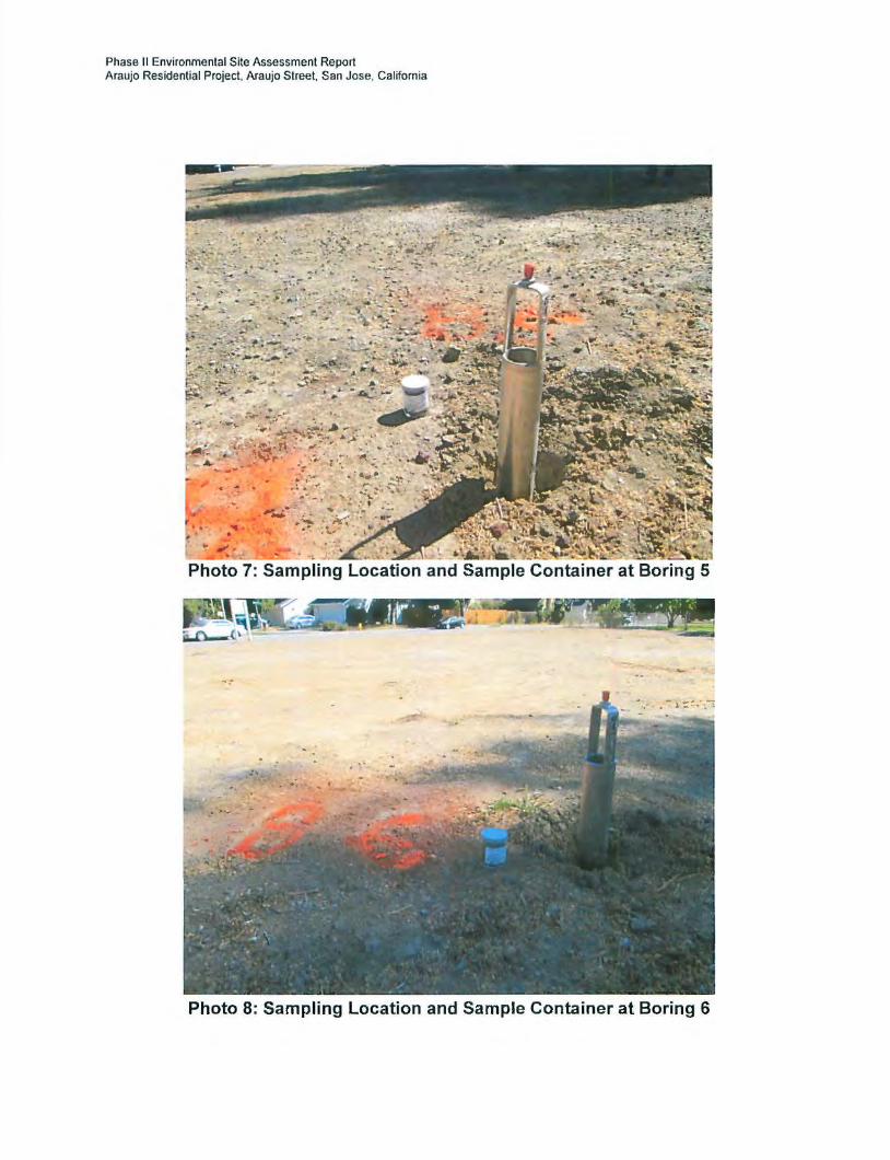
Phase II Environmental Site Assessment Report Araujo Residential Project, Araujo Street. San Jose. California
. Photo 7: Sampling Location and Sample Container at Boring 5
Photo 8: Sampling Location and Sample Container at Boring 6

Phase II Environmental Site Assessment Report Araujo Residential Project. Araujo Street. San Jose. California
Photo 9: Sampling Location and Sample Container at Boring 7
Photo 10: Sampling Location and Sample Container at Boring 8

Phase II Environmental Site Assessment Report Araujo Residential Project, Araujo Street, San Jose, California
ATTACHMENT 4 CALIFORNIA LABORATORY SERVICES
October 5, 2015 RESULTS

CALIFORNIA LABORATORY SERVICES 3249 Fi~trald Road Rantbo Cordova. CA 95742
October 05,2015
Farshad Vakili
Phase I Assessment
273 Canyon Falls Dr Folsom, CA 95630
Project Name: ARAUJO Residential Project
CLS Work Order#: CYI0825 coc #: 156511-156516
Enclosed are the results of analyses for samples received by the laboratory on 09/21/15 08:15. Samples were analyzed pursuant to client request utilizing EPA or other ELAP approved methodologies. I certify that the results are in compliance both technically and for completeness.
Analytical results are attached to this letter. Please call if we can provide additional assistance.
Sincerely,
~b James Liang, Ph.D. Laboratory Director
CA DOHS ELAP Accreditation/Registration number 1233

CALIFORNIA LABORATORY SERVICES
Page 3 of32 10/05/15 1404
Phase I Assessment ProJect: ARAUJO Residential Project
273 Canyon Falls Dr Project Number: (none) CI.S Work Order#: CYI0825
Folsom, CA 95630 Project Manager: Farshad Vakili coc #: 156511-156516
CAM 17 Metals
Reporting
Analytc Result Limit Units Dilution Batch Prepared Analyzed Method Notes
Boring I Ill Foot (CYI0825-0I) Soil Sampled: 09/19/15 14:20 Received: 091ll/15 08: IS
Antimony NO 2.5 mglkg CY06498 09122/15 09122/IS EPA 60108
Anenit 5.7 2.0 10 09122/15 EPA6020
Barium 170 1.0 09122115 EPA60108
Beryllium ND 1.0
Cadmium 1.1 1.0
Cbromium 38 1.0
Cobalt II 1.0
Copper 42 1.0
Lead 9.7 2.5
Mercury 0.68 0.50 CY06497 09122/15 09122/15 EPA 7471A
Molybdenum ND 1.0 CY06498 09122/IS 09/22/15 EPA6010B
Nickel 79 1.0
Selenium NO 5.0 10 09122/IS EPA 6020
Silver ND 1.0 09/22/15 EPA6010R
Thallium ND 2.0 10 09122/15 EPA6020
Vanadium 30 1.0 09122115 EPA 60108
Zinc 65 1.0 QB·I
Boring2 Ill Foot (CYI0825-02) Soil Sampled: 09/19/15 14:45 Received: 091ll/15 08: IS
Antimony ND 2.5 mglkg CY06498 09122115 09122/15 EPA60108
Anenlc 6.3 20 10 09122115 EPA 6020
Barium 260 1.0 09122/15 EPA6010B
Beryllium ND 1.0
Cadmium 16 1.0
Chromium 58 1.0
Cobalt IS 1.0
Copper 53 1.0
Lead 13 2.5
Mercury 0.14 0.10 C"Y06497 09122/15 09/22/15 EPA 7471A
Molybdenum ND 1.0 CY06498 09122115 09122115 EPA 6010B
Nickel 120 1.0
CA DOHS ELAP Accredilation/Rcgistration Number 1233
3249 Fitzgerald Road Rancho Cordova, CA 95742 www.califomialab.com 916-638-7301 Fax:916-638-4510

CALIFORNIA LABORATORY SERVICES
Page4 of32 10105/15 14 04
Phase I Assessment Project: ARAUJO Residential Project 273 Canyon Falls Dr Project Number: [none) CI.S Work Ordtr II: CVI082S Folsom. CA 95630 Project Manager: Farshad Vakili COC II: 156511-156516
CAM 17 Metals
Reporting Analytc Result Limit Units Dilution Batch Prepared Analy:r.cd Method Notes
Boring 2 112 Foot (CVI0825-02) Soil Sampled: 09119/15 14:45 Received: 09121115 08:15
Selenium ND 5.0 mglkg 10 CV06498 09122/IS EPA6020
Silver ND 1.0 09/22/IS EPA6010B
Thallium ND 2.0 10 09/22/IS EPA 6020
Vanadium 37 1.0 09122/IS EPA6010B
Zinc 88 1.0 QB·I
Boring 3 112 Foot (CVI0825-03) Soil Sampled: 09/19/15 15:00 Received: 09121115 08: IS
Antimony NO 2.5 mg!kg CV06498 09122/IS 09!22/IS EPA6010B
Arsenic 7.6 2.0 10 09122/IS EPA6020
Barium 220 1.0 09!22/IS EPA6010B
Beryllium NO 1.0
Cadmium 1.4 1.0
Chromium 49 1.0
Cobalt 13 1.0
Copper 56 1.0
Ltad 13 2.5
Mercury 0.14 0.10 CY06497 09!22/IS 09122/IS EPA 7471A
Molybdenum NO 1.0 CV06498 09!22/IS 09!22/IS EPA60108
Nickel 82 1.0
Selenium NO 5.0 10 09!22/IS EPA6020
Silver NO 1.0 09!22/IS EPA6010B
Thallium NO 2.0 10 09!22/IS EPA6020
Vanadium 39 1.0 09122/IS EPA60JOB
Zinc 88 1.0 QB-1
CA DOHS ELAP Accreditation/Registration Number 1233
3249 Fitzgerald Road Ranc:bo Cordova, CA 95742 www.c:alifomialab.c:om 916-638-7301 Fax:916-638-4510

CALIFORNIA LABORATORY SERVICES
Page 5 of32 10105/15 14 04
Phase I Assessment Project: ARAUJO Residential Project
273 Canyon Falls Dr Project Number: (none) CLS Work Onlrr II: CYI0825
Folsom, CA 95630 Project Manager: Farshad Vakili COC H: 1565JJ.JS6SI6
CAM 17 Metals
Reporting Anal)'le Result Limit Units Dilution Batch Prepared Analyzed Method Notes
Boring 4 112 Fool (CYI0825-04) Soil Sampled: 09/19115 15:10 Reuind: 09121115 08:15
Antimony ND 25 mglkg CY06498 09122/IS 09122/IS EPA6010B
Arsenic 7.7 2.0 10 09122/IS EPA6020
Barium 220 1.0 09122/IS EPA6010B
Beryllium ND 1.0
Cadmium 1.4 1.0
Chromium so 1.0
Cobalt 13 1.0
Copper 54 1.0
Lend 12 2.5
Mercury 0.28 0.10 CY06497 09122115 09122115 lii'A 7471A
Molybdenum NO 1.0 CY06498 09122115 0912211S EI'A6010H
Nickel 76 1.0
Selenium NO S.O 10 09122/IS EPA 6020
Silver NO 1.0 09122115 EPA6010H
Thallium NO 2.0 10 09122/IS EPA 6020
Vanadium 40 1.0 09122/IS EPA6010B
Zinc 83 1.0 QB-1
BoringS 112 Fool (CY10825-0S) Soil Sampled: 09119115 15:17 Rtctind: 09121115 08:15
Antimony NO 2.5 mf,/kg CY06498 09122/IS 0912211S EPA6010B
Arsenic 7.0 2.0 10 0912211S EPA6020
Barium 230 1.0 0912211S EPA6010R
Beryllium NO 10
Cadmium 1.4 1.0
Chromium S3 1.0
Cobalt 14 1.0
Copprr 57 1.0
Ltad 9.8 2.5
Mercury 0.20 0.10 CY06497 09122115 09122/IS EPA 7471A
Molybdenum NO 1.0 CY06498 09122/IS 09122/IS EPA60JOB
l"iiekel 99 1.0
CA DOHS ELAP Accrcditution/Rcgistrotion Number 1233
3149 Fitzgerald Road Rancho Cordova, CA 95741 www.callfomialab.com 916-638-7301 Fax: 916-638-4510

CALIFORNIA LABORATORY SERVICES
Page 6 of32 10/05/15 14 04
Phase I Assessment Project: ARAUJO Residential Project
273 Canyon Falls Dr Project Number: [none) CLS Work Order II: CYJ0825
Folsom. CA 95630 Project Manager: Farshad Vakili COC II: 156511-156516
CAM 17 Metals
Reportinll Analyte Result Limit Units Dilution Balch Prepared Analyzed Method Notes
Boring 5 112 Foot (CYJ0825-05) Soil Sampled: 09n9tl5 15:17 Rereind: 0912Jn5 08:15
Selenium NO 5.0 miJ/kll 10 CY06498 09122/IS EPA6020
Silver ND 1.0 09/22/15 EPA6010B
Thallium NO 2.0 10 09122/IS EPA6020
Vanadium 41 1.0 09122/IS EPA6010B
Zinc 91 1.0 Qll-1
Boring 6 112 Foot (CYI0825-06) Soil Sampled: 09/19/15 15:25 Rereind: 09121/15 08:15
Antimony ND 2.5 mglkg CY06498 09122/IS 09122/15 EPA60101l
Arsenic 6.6 2.0 10 09/22/15 EPA6020
Barium 220 1.0 09/22/IS EPA6010R
lkryllium ND I 0
Cadmium 1.3 1.0
Chromium 51 1.0
Cobalt 14 1.0
Copper 55 1.0
Lead 13 2.5
Mercury 12 10 100 CY06497 09122/IS 09/22/IS EPA 7471A
Molybdenum ND 1.0 CY06498 09122/IS 09122/IS EPA6010B
Nickel 98 1.0
Selenium ND 5.0 10 09/22/IS EPA 6020
Silver ND 1.0 09122/IS EPA6010B
Thallium ND 2.0 10 09/22/15 EPA 6020
Vanadium 36 1.0 09122/IS EPA6010B
Zinc 200 1.0 QR·I
CA DOHS ELAP Accreditation/Registration Number 1233
3249 Fitzgerald Road Rancho Cordova, CA 95742 www.californialab.com 916-638-7301 Fax: 916-638-4510

CALIFORNIA LABORATORY SERVICES
Page 7 of32 10/05/15 14:04
Phase I Assessment ProJect: ARAUJO Residential Project
273 Canyon Falls Dr Project Number: [none] CLS Work Order 1#: CYI0825
Folsom, CA 95630 Project Manager: Farshad Vakili COC #: IS6Sll-IS6SI6
CAM 17 Metals
Reporting Analyle Result Limit Units Dilution Batch Prepared Analyzed Method Notes
Boring 7 112 Foot (CYI082~7) Soil Sampled: 09/19/IS IS:33 Receivtd: 09121/15 08:1S
Antimony ND 2.S mw\g CY06498 09122/lS 09122/JS EPA60JOB
r\nenic 7.7 2.0 10 09122115 EPA 6020
Barium 210 1.0 09122115 EPA 6010B
Beryllium NO 1.0
Cadmium 1.3 1.0
Chromium so 1.0
Cobalt 13 1.0
Copper 54 1.0
Ltad 12 2.S
Mercury 0.11 0.10 CY06497 09122/JS 09122/lS EPA 7471A
Molybdenum NO 1.0 CY06498 09122115 09122/IS EPA6010B
Nickel 7S 1.0
Selenium NO 5.0 10 09122115 EPA 6020
Silver NO I 0 09122115 EPA6010B
Thallium ND 2.0 10 09122115 EPA 6020
Vanadium 41 1.0 09122115 EPA6010B
Zinc 83 1.0 Ql:l·l
Boring 8 112 Foot (CYI08~8) Soil Sampled: 09/19/IS 15:45 Receivtd: 09121/IS 08: IS
Antimony ND 2.5 mw\g CY06498 09122/IS 09122/JS EPA6010B
r\nenlc 6.3 2.0 10 09122115 EPA 6020
Barium 230 1.0 09122115 EPA 60108
Beryllium NO 1.0
Cadmium 1.3 1.0
Chromium 64 1.0
Cobalt IS 1.0
Copper S7 1.0
Lead 10 2.5
Mtrcury 0.21 0.10 CY06497 09122115 09/22115 EPA 7471A
Molybdenum NO 1.0 CY06498 09122/JS 09122/IS EPA6010B
Nickel 110 1.0
CA OOHS ELAP Accreditation/Registration Number 1233
3249 Fitzgerald Road Ranc:ho Cordova, CA 95742 www.c:alifornialab.com 916-638-7301 Fax:916-638-4510

CALIFORNIA LABORATORY SERVICES
Page 8 of32 10/05/1 S 14 04
Phase I Assessment Project: ARAUJD Residential Project
273 Canyon Falls Dr Project Number (none) Cl.S Work Order 1#: CYIOS:ZS Folsom, CA 95630 Project Manager: Farshad Valcili COC#: 156511-156516
CAM 17 Metals
Reponing Analyte Result Limit Units Dilution Batch Prepared Analyml Method Nules
Boring 8 112 Foot (CVI08Z5-08) Soil Sampled: 09/19/15 15:45 Received: 09121115 08: IS
Selenium ND 5.0 mg!kg 10 CY06498 09122/IS EPA6020
Silver ND 1.0 09122/IS EPA60108
Thallium ND 2.0 10 09122/IS EPA6020
Vanadium 39 1.0 09122/IS EPA60108
Zinc 87 1.0 QB·I
Boring I 1112 ··not (CYI08Z5-09) Soil Sampled: 09/19/15 16:22 Received: 09121115 08:15
Anttmony ND 2.5 mg!kg CY06498 09/22/IS 09122/IS EPA60108
Antnit 6.8 2.0 10 09122/IS EPA6020
Bllrium 230 1.0 09/22/IS EPA60108
Beryllium ND 1.0
Cadmium 1.3 1.0
Chromium 55 1.0
Cobalt 15 1.0
Copper 57 1.0
Lead 13 2.5
Mercury 0.48 0.10 CY06497 09122/15 09122/IS EPA 7471A
Molybdenum ND 1.0 CY06498 09122/IS 09122/IS EPA6010B
Nickel 120 1.0
Selenium ND 5.0 10 09122/IS EPt\6020
Silver ND 1.0 09122/IS EPA6010B
Tlulllium ND 2.0 10 09122/IS EPA6020
Vanadium 39 1.0 09122/IS EPA60108
Zioc 92 1.0 QB·I
CA OOHS ELAP Accredilation/Rcgistralion Number 1233
3249 Fitzgerald Road Rancho Cordova, CA 95742 www.califomialab.com 916-638-7301 Fax:916-638-4510

CALIFORNIA LABORATORY SERVICES
Page9 of32 10/05/15 14 04
Phose I Assessment J>roject: ARAUJO Residential Project
273 Canyon Falls Dr Project Number: [none I CLS Work Order 1#: CYI0825
Folsom. CA 95630 Project Mtlll8ger: Farshad Vakili coc 1#: 156511-156516
CAM 17 Metals
Reporting Analyte Result limit Units Dilution Batch Prqwed Analyzed Method Notes
Boring 2 1112 Foot (CYJ0825-IO) Soil Sampled: 09/19/15 16:30 Rtuind: 09121/15 08:15
Antimony NO 2.5 mg/kg CY06498 09122115 09/22115 EPA6010U
Arsenic 6.7 2.0 10 09/22115 EPA6020
Barium 210 1.0 09122115 EPA6010B
Beryllium NO 1.0
Cadmium 1.7 1.0
Chromium 50 1.0
Cobalt 13 1.0
Copper 54 1.0
Lead 12 2.5
Mercury 0.23 0.10 CY06497 09122/IS 09122115 EPA 7471A
Molybdenum NO 1.0 CY06498 09122115 09122115 EPA60109
Nickel 91 1.0
Selenium NO 5.0 10 09122115 EPA 6020
Silver NO 1.0 09/22/IS m•A6010B
Thallium NO 2.0 10 09122115 EPA 6020
Vanadium 39 1.0 09122/IS EPA6010B
Zinc 82 1.0 QB·I
Boring 3 1112 Foot (C¥10825-11) Soil Sampled: 09/19/15 16:40 Received: 09121/15 08:15
Antimony NO 2.5 mg/kg CY06498 09122115 09122115 EPA6010B
Arsenic 7.8 2.0 10 09122/IS EPA6020
Barium 210 1.0 09122/IS EPA6010B
Beryllium ND 1.0
Cadmium 1.3 1.0
Chromium 51 1.0
Cobalt 12 1.0
Copper 53 1.0
Lead II 2.5
Mercury 0.12 0.10 CY06497 09122115 09122115 EPA 7471A
Molybdenum ND 1.0 CY06498 09122/IS 09122/lS EPA6010R
Nickel 73 1.0
CA DOHS ELAP Accreditation/Registration Number 1233
3249 Fitzgerald Road Rancho Cordova, CA 95742 www.califomialab.com 916-638-730 I Fax: 916-638-4510

CALIFORNIA LABORATORY SERVICES
Page 10of32 10/05/15 14 04
Phase I Assessment Project: ARAUJO Residential Project 273 Canyon Falls Dr Project Number: [none) CI..S Work Order#: CYI0825 Folsom, CA 95630 Project Manager: Farshad Vakili coc #: 156511-156516
CAM 17 Metals
Reponing Analytc Resull l.imil Units Dilution Balch Prepan:d Analyzed Method Notes
Boring 3 11/2 Foot (CVI082S-II) Soil Sampled: 09/19/15 16:40 Received: 09/21115 08: IS
Selenium NO 5.0 mgl\g 10 CV06498 09122/IS EPA6020
S1lver NO 1.0 09/22/IS EPA6010B
Thallium NO 2.0 10 09122/IS EPA6020
Vanadium 42 1.0 09122/IS EPA6010B
Zinc: 81 1.0 Qll-1
Boring 4 11/2 Foot (CVI082S-12) Soil Sampled: 09/19/15 17:00 Received: 09121115 08:15
Antimony NO 2.5 miJ/kg CV06498 09/22/IS 09/22/IS EPA 60108
Arsenic: 7.5 2.0 10 09/22/IS EPA6020
Barium 220 1.0 09/22/IS EPA6010B
Beryllium NO 1.0
Cadmium 1.3 1.0
Cbromium 48 1.0
Cobalt 12 1.0
Coppu 50 1.0
Lead 10 2.5
~tuc:ury 0.11 0.10 CV06497 09122/IS 09/22/IS EPA 7471A
Molybdenum NO 1.0 CV06498 09/22/IS 09122/IS EPA 60108
Nickel 67 1.0
Selenium NO 5.0 10 09/22/IS EPA 6020
Silver NO 1.0 09122/IS EPA6010B
Thallium NO 2.0 10 09/22/IS EPA 6020
Vanadium 41 1.0 09/22/IS EPA6010B
Zinc: 76 1.0 Qll·l
CA DOHS ELAP Accreditation/Registration Number 1233
3249 Fitzgerald Road Rancho Cordova, CA 95742 www.califomialab.com 916-638-7301 Fax: 916-638-4510

CALIFORNIA LABORATORY SERVICES
Page 11 of32 10/05/15 14:04
Phase I Assessment Project: ARAUJD Residential Projt.:ct
273 Canyon Falls Dr Project Number: [none) CLS Work Order II: CYI0825 Folsom, CA 95630 Project Manager: Farshad Vakili COC II: 156511-156516
CAM 17 Metals
Reponing Analy1c Result Limit Units Dilution Batch Prepared Analyzed Method Notes
Boring 5 1112 Foot (CYI0815-13) Soil Sampled: 09/19/15 16:13 Rtteind: 09/21/15 08:15
Antimony ND 2.5 mglkg CY06498 09122/IS 09122115 EPA6010B
Anenic 6.9 2.0 10 09122/IS EPA6020
Barium 200 1.0 09122/15 EPA 60108
Beryllium ND 1.0
Cadmium 1.3 1.0
Chromium 46 1.0
Cobalt 12 1.0
Copper 52 1.0
Lead 11 2.5
Mercury 0.16 0.10 CY06497 09/22/15 09122/15 EPA 7471A
Molybdenum ND 1.0 CY06498 09/22/1S 09122115 EPA6010B
Nickel 74 1.0
Selenium ND 5.0 10 09122/IS EPA6020
Silver ND 1.0 09122/15 EPA6010B
Thallium ND 2.0 10 09122115 EPA 6020
Vanadium 36 1.0 09122/1S EPA6010B
Zinc 80 1.0 QB-1
Boring 6 11/2 Foot (CYI0815-14) Soil Sampled: 09/19/15 15:55 Received: 09/21/15 08:15
Antimony ND 2.5 mglkg CY06498 09/22/IS 09/22/IS EPA6010B
Aneoic 6.8 2.0 10 09/22/IS EPA6020
Barium 230 1.0 09/22/IS EPA6010B
Beryllium ND 1.0
Cadmium 1.3 1.0
Chromium 59 1.0
Cobalt 14 1.0
Copper 54 1.0 Lead 12 2.5 Mercury 0.21 0.10 CY06497 09122/15 09/22/15 EPA 7471A
Molybdenum NO 1.0 CY06498 09122/IS 09122/IS EPA6010B
Nickel 100 1.0
CA DOHS ELAP Accreditation/Registration Number 1233
3249 Fitzgerald Road Rancho Cordova, CA 95742 www.califomialab.com 91~8-7301 Fas: 91~8-4510

CALIFORNIA LABORATORY SERVICES
Page 12 of32 10/05/15 14 04
Phase I A!l!lessment Project: ARAUJO Residcntiall'roject
273 Canyon Falls Dr Project Number: [none I Cl.S Work Order II: CVI0815
Folsom. CA 95630 Project Manager: Farshad Vakili COC II: 156511-156516
CAM 17 Metals
Reporting
Anai)1C Result Limit Units Dilution Batch Prepared Analyzed Method Notes
Boring 6 1111 Foot (CV1081S-14) Soil Sampltd: 09/19/15 15:55 Recelnd: 09111115 08:15
Selenium ND 5.0 mglkg 10 CY06498 09122/JS EPA 6020
Silver ND 1.0 09122/JS EPA60JOB
Thallium ND 2.0 10 09122/IS EPA6020
Vanadium 41 1.0 09122/IS EPA6010B
Zinc 85 1.0 QB·I
Boring 7 11/ll.'oot (CVI0825-IS) Soil Sampltd: 09/19115 17:17 Received: 09111115 08: IS
Antimony ND 2.5 mglkg CY06498 09122/IS 09122/IS El'A6010R
Arsenic 7.3 2.0 10 09122/15 EPA6020
Barium 210 1.0 09122/15 EPA6010B
Beryllium ND 1.0
Cadmium 1.3 1.0
Chromium 51 1.0
Cobalt 12 1.0
Copper 54 1.0
Lead IS 2.5
Mercury 0.13 0.10 CY06497 09122115 09122/15 EI'A 7471A
Molybdenum NO 1.0 CY06498 09122/IS 09122/15 EPA6010B
Nickel 74 1.0
Selenium ND 5.0 10 09/22115 f~A6020
Silver ND 1.0 09122/IS EI'A6010B
Thallium NO 2.0 10 09122/IS EPA 6020
Vanadium 39 1.0 09122/IS EPA 60108
Zinc 82 1.0 QB·I
CA DOHS ELAP Accreditation/Registration Number 1233
3249 Fitzgerald Road Rancho Cordova, CA 95742 www.c:alifornialab.com 916-638-7301 Fax:916-638-4510

CALIFORNIA LABORATORY SERVICES
Page 13of32 10/05/15 1404
l'hase I Assessment Project: ARAUJO Residential Project
273 Canyon Falls Dr Project Number: [none) CLS Work Order 1#: CVI0825
Folsom, CA 95630 Project Manager: Farshad Vakili coc 1#: 156511-156516
CAM 17 Metals
Reponing Analy1e Result Limit Units Dilution Batch Prepared Analyzed Method Notes
Boring 8 11/2 Foot (CVI0825-16) Soil Sampled: 09/19/IS 16:10 Rueind: 09/21/IS 08:15
Antimony ND 2.5 mgl\g CY06498 09!22/IS 09!22/IS EPA6010B
Anenic 6.8 2.0 10 09!22/15 EPA6020
Barium 220 1.0 09!22/15 EI'A6010B
Beryllium ND 1.0
Cadmium 1.3 1.0
Chromium 54 1.0
Cobalt 13 1.0
Copper 52 10
Leud 8.7 2.5
Mercury 0.16 0.10 CY06497 09/22/15 09/22/15 lii'A 747tA
Molybdenum NO 1.0 CY06498 09/22/15 09/22/15 l'PA6010H
Sickel 84 1.0
Selenium NO 5.0 10 09!22/15 EI'A6020
Stiver NO 10 09122/15 EPA 60108
Thallium 4.9 2.0 10 09!22/15 EPA 6020
Vanadium 40 J() 09/22/15 EI'A6010B
Zinc 76 10 {)II· I
CA DOHS ELAP Accreditation/Rcgistmtion Number 1233
3249 Fitzgerald Road Rancho Cordova, CA 95742 www.californialab.com 916-638-7301 Fax:916-638-45JO

CALIFORNIA LABORATORY SERVICES
Page 14 of32 10/05/15 14:04
Phase I Assessment Project: ARAUJO Residential Project 273 Canyon Falls Dr Project Number: [none] CLS Work Order#: CYI0825 Folsom, CA 95630 Project Manager: Farshad Vakili coc #: 156511-156516
Organochlorine Pesticides by EPA Method 8081A
Reponing Analyte Result Limit Units Dilution Batch Prepared Analyzed Method Notes
Boring I 112 Foot (CYI0825-0I) Soil Sampled: 09/19/15 14:20 Received: 09121115 08:15
4,4'-DDD NO 75 jlg/kiJ 10 CY06S49 09123115 0912S/IS EPA8081A
4,4'-DDE 710 300 40
4,4'-DDT 190 75 10
Aldrin ND 10
alpha·BHC ND 20
beta-BHC NO 100
Cblordone-tecbnical 1500 200
delta-BHC NO 100
Dieldrin 38 10
Endosulfan I NO ISO Endosulfan II NO ISO Endosulfan sulfate ND ISO Endrin ND ISO Endrin aldehyde NO ISO gamma-BHC (Lindane) ND 100
Heptachlor NO 50
Heptachlor epoxidc NO 20
Methoxychlor NO ISO
Mirex ND 30
Toxaphene NO 200
Surrogate: Decachlorobipheny/ 8/% 52-141
Surrogate: Tetrach/oro-meta-xy/ene 81% 46-139
Boring 2 112 Foot (CYI0825-{12) Soil Sampled: 09/19/15 14:45 Received: 09121115 08:15
4,4'-DOD NO 75 Jig/kg 10 CY06S49 09/23/IS 09125115 EPA8081A
4,4'-DDE 890 300 40
4,4'-DDT 230 75 10
Aldrin NO 10
alpha-BHC NO 20
beta-BHC NO 100
CA DOHS ELAP Accreditation/Registration Number 1233
3249 Fitzgerald Road Rancho Cordova, CA 95742 www.californialab.com 916-638-7301 Fax: 916-638-4510
.... iJ.&QJ.£,:;;,Q uu&t , , , iQ!l#Ql .. i&#§Wii.Git1&:4.J!Mt[t.iM&&&:;;¥.%#!@!l:WS:MMH4 ...... ·.9.%Whi!®f&'#.&u4Jit. .. A. !IWR'#W%%f¥4;tA:;::m;& _; h&\!!!MGu .... oQ.b...,_l%.twiWR i ..... uP. . , A .. 4~PMMM1WM4% ...... N.\. ;.J .. t.W:.%!4\'f.-·

CALIFORNIA LABORATORY SERVICES
Page 15of32 10/05/15 14 04
Phuse I Assessment Project: ARAUJO Residential Project 273 Canyon Falls Dr Project Number. (none) CLS Work Order 1#: CYI0825 Folsom, CA 95630 Project Manager: Farshad Vakili COC II: 156511-156516
Organochlorine Pesticides by EPA Method 808JA
Reponjng Anatyte Result Limit Units Dilution Balch Prepared Analyzed Method Notes
Boring 2 112 Fool (CYI0825-02) Soil Sampled: 09/19/15 14:45 Received: 09121/15 08: IS
Chlordanr-lechnical 1500 200 IJg/kg 10 CY06S49 0912SIIS EPA808tA
delJa-BHC NO 100
Dieldrin NO Ill
Endosulfan I NO ISO
Endosulfan II NO ISO
Endosulfan sulfate ND ISO
Endrin ND ISO
Endrin aldehyde ND ISO
gamma-BIIC (Lindane) NO 100
Heptachlor NO 50
Heptachlor epoxide ND 20
Methoxychlor NO ISO
Mtrex ND 30
Toxaphene NO 200
Surrogate: Decachlorobiphenyl 70% 52-141
Surrogate: Tetrachloro-meta-xylene 66% 46-/39
Boring 3 112 Fool (CYI082.~) Soil Sampled: 09/19/IS 15:00 Received: 09121115 08: IS
4,4'-DDD NO 75 IJg/kg 10 CY06S49 09123/IS 09125/IS RPA8081A
4,4'-DDE 1500 750 100
4,4'-DDT 330 75 10
Aldrin ND 10
alpha-BHC NO 20
beta-BIIC NO 100
Chlordane-leehnic:al 1900 200
delJa-BIIC ND 100
Dieldrin 120 10
Endosulfan I NO ISO
Endosul fan II ND ISO
Endosul fan sui fate NO ISO
CA DOHS ELAP Accreditation/Registration Number 1233
3249 Fitzgerald Road Rancho Cordova, CA 95742 www.callfornialab.com 916-638-7301 Fax:916-638-4510

CALIFORNIA LABORATORY SERVICES
Page 16 of32
Phase I Assessment
273 Canyon Falls Dr
Folsom, CA 9S630
Analyte
Doring 3 112 Foot (CYI0825-0J) Soil
Endrin
Endrin aldehyde
gamma-BHC (Lindane)
Heptachlor
I feptachlor epoxide
Methoxychlor
M1rex
Toxaphene
Surrogate: Decachlorobtphenyl
Surrogate: Tetrachloro-meta-:rylene
Doring 4 112 Foot (CYI0825-04) Soil
4,4'-DDD
4,4'-DDE
4,4'-DDT
Aldrin
alpha-BHC
betn-BHC
Cblordnne-tethnital
delta-BHC
Dieldrin
Endosulfan I
Endosul fan II
Endosulfan sulfate
Endrin
Endrin aldehyde
gamma-BHC (Lindane)
lleptachlor
Heptachlor epoxide
Methoxychlor
Project: ARAUJO Residential Project
Project Number (none)
Project Manager Farshad Vakili
Organochlorine Pesticides by EPA Method 8081A
Reporting Result l.imit Units Dilution Balch Prepared
Sampled: 09/19/15 15:00 Rrreivtd: 09121/15 08:15
NO ISO l'g/kll 10 CY06S49
NO ISO
NO 100
NO so NO 20
NO 150
NO 30
NO 200
71% 52-141
71% ./6-139
Sampled: 09/19115 l!li:IO Received: 09121115 08:15
NO 75 l'g/kg 10 CY06S49 09123/JS
1400 7SO 100
340 75 10
NO 10
NO 20
NO 100
1900 200
NO 100
110 10
NO ISO
NO ISO
NO ISO
NO ISO
NO ISO
NO 100
NO so NO 20
NO ISO
CA DOHS ELAP Accreditation/Registration Number 1233
10/0S/IS 1404
CLS Work Order 1#: CYI0825 coc #: IS6SII-156516
Analyzed Method
09/2S/IS EPA8081A
09/2.S/IS EPA808JA
Notes
3249 Fitzgerald Road Rancho Cordova, CA 95742 www.californialab.com 916-638-7301 Fax: 916-638-4510

CALIFORNIA LABORATORY SERVICES
Page 17 of32
Phase I Assessment 273 Canyon Falls Dr
Folsom, CA 95630
Analyte
Doring 4 1/2 Fool (CV10825-04) Soil
Mtrex
Toxaphene
Su"ogaJe: Decach/orobipheny/
Surrogate: Tetrach/oro-meiD-xylene
Doring S 1/2 Fool (CVI082S-OS) Soil
4.4·-ooo
4,4·-ooE
4,4·-ooT
Aldrin
alpha-BHC
beta-BHC
Chlordant-lecbnltal
delta-BHC
Dieldrin
Endosulfan I
Endosulfan II
Endosulfan sulfute
Endrin
Endrin aldehyde
gamma-BHC (Lindane)
lleptachlor
Ileptachlor epox ide
Methoxychlor
Mirex
Toxaphene
Su"ogate: Decachlorobiphenyl
Surrogate: Tetrachloro-meta-xylene
Proj«t: ARAUJO Residential Project
Proj«t Number: (none)
Project Manager: Farshad Vakili
Organochlorine Pesticides by EPA Method 808JA
Reporting Result Limit Units Dilution Batcb Prepared
Sampled: 09/19/15 15:10 Reteived: 09/21/IS 08:15
ND 30 llg/kiJ 10 CY06S49
ND 200
74% 52-141
78% -16-139
Sampled: 09/19/15 15:17 Recrived: 09/21115 08:15
ND 75 llg/kg 10 CY06S49 09123/JS
1100 380 so 290 75 10
ND 10
ND 20
ND 100
1600 200
NO 100
39 10
NO ISO
NO ISO
ND ISO
NO ISO
NO ISO
NO 100
NO 50
NO 20
ND ISO
ND 30
ND 200
75% 52-141
76% 46-139
CA DOHS ELAP Accreditation/Registration Number 1233
10/05/15 14 04
CI.S Work Order #1: CVI082S COC#I: 156Sil-156SI6
Analyzed Method
09125115 EPA8081A
09125/JS EPA8081A
Notes
3249 Fitzgerald Road Rancho Cordova, CA 95742 www.califomialab.com 916-638-7301 Fax:916-638-4SIO

CALIFORNIA LABORATORY SERVICES
Page 18of32 10/05115 14 04
Phase I Assessment Project: ARAUJO Residential Project
273 Canyon Falls Dr Project Number: [none) CLS Work Ordrr II: CYI0825 Folsom. CA 95630 Project Manager: Farshad Vakili coc #: IS6Sll-156516
Organochlorine Pesticides by EPA Method 8081A
Reporting Analy1e Result Limit Units Dilution Batch Prepared Analyzed Method Notes
Boring 6 112 Foot (CYJ082S-&6) Soil Samplrd: 09/19/15 15:25 Rrcrivrd: 09121115 08:15
4.4·-ooo NO 75 IJg/kg 10 CY06S49 09123/IS 0912SIIS F.PA 8081A
4,4'-DDE 860 380 50
4,4'-DDT 240 75 10
Aldrin NO 10
alpha-BHC NO 20
beta-BIIC NO 100
Cblordane-trcbnical 1500 200
delta-IUIC NO 100
Dieldrin 31 10
Endosulfan I NO ISO
Endosul fan II NO ISO
Endosulfun sulfate NO 150
Endnn ND 150
Endnn aldehyde NO 150
gamma-BHC (Lindane) NO 100
lleptachlor NO 50
Heptachlor epoxide NO 20
Methoxychlor NO ISO
Mm:x NO 30
Toxuphenc NO 200
Surrogate: Decachlorobiphenyl 76% 52-J.II
Surrogate: Tetrachloro-meta-xylene 76% 46-139
Boring 7 112 Foot (CYJ0825-07) Soli Samplrd: 09/19/15 15:33 Rrcrivrd: 09121115 08:15
4,4'-DDO NO 75 j.lg/kg 10 CY06S49 09123/IS 0912SIIS EPA 8081A
4,4'-DDE 1600 750 100
4,4'-DDT 320 7S 10
Aldrin ND 10
alpha-BHC ND 20
beta-BIIC ND 100
CA DOHS EI.AJ> Accreditation/Registration Number 1233
3249 Fitzgerald Road Rancho Cordova, CA 95742 www.californialab.com 916-638-7301 Fax:916-638-4510

CALIFORNIA LABORATORY SERVICES
Page 19of32 10105/15 14 04
Phase I Assessment Project: ARAUJO Residential Project
273 Canyon Falls Dr Project Number: [none) CLS Work Order 1#: CYI0825 Folsom, CA 95630 Project Manager: Farshad Vakili coc #: 156511-156516
Organochlorine Pesticides by EPA Method 8081A
Reporling Analyte Result Limit Units Dilution Balch Prepared Analyzed Method Notes
Boring 7 112 Foot (CYI0825-07) Soil Sampled: 09119115 15:33 Receind: 09121/15 08:15
Cblonlane-tec:hnic:al 1800 200 llllikll 10 CY06S49 0912SIIS EPA808IA
delta·BHC ND 100
Dieldrin 110 10
Endosulfan I ND 150
Endosulfan II ND 150
Endosul fan sui fate ND 150
Endrin ND 150
Endrin aldehyde ND ISO
gamma-BHC (Lindane) ND 100
Heptachlor NO 50
Heptachlor cpoxide ND 20
Methoxychlor ND ISO
Mirex ND 30
Toxaphene ND 200
Surrogate: Decach/orobiphenyl 76% 52-1·11
Surrogate: Tetrachloro-meta-xylene 78% 46-139
Boring 8 112 Foot (CYI0825-08) Soil Smmpled: 09119115 15:45 Received: 09121115 08:15
4,4'-DDD ND 75 ll!ll1cll 10 CY06S49 09123/IS 0912SIIS EPA8081A
4,4'-DDE 970 380 so 4,4'-DDT 240 75 10
Aldrin ND 10
alpha-BHC ND 20
beta-BI~C ND 100
Cblonlane-tec:bnic:al 1400 200
delta-BHC ND 100
Dieldrin 33 10
Endosulfan I NO 150
Endosulfan II NO 150
Endosul fan sui fate NO 150
CA DOHS ELAP Accreditation/Registration Number 1233
3249 Fitzgerald Road Rancho Cordova, CA 95742 www .californialab.com 916-638-7301 Fax:916-638-4510

CALIFORNIA LABORATORY SERVICES
Page 20of32
l'hase I Assessment
273 Canyon Falls Dr
Folsom, CA 95630
Project: ARAUJO Residentiall'roject
Project Nwnber (none(
Project Manager Farshad Vakili
Organochlorine Pesticides by EPA Method 8081A
CA DOHS ELAP Accreditation/Registration Number 1233
10/0S/IS 14:04
Cl..S Work Order#; CYI0825
coc #/: 156511-156516
3249 Fitzgerald Road Rancho Cordova, CA 95742 www.callfornialab.com 916-638-7301 Fax: 916-638-4510

CALIFORNIA LABORATORY SERVICES
Page 21 of32
Phase I Assessment
273 Canyon Falls Dr
Folsom, CA 9S630
Analyte
Boring I 1112 Foot (CYI082S-09) Soil
Mirex
Toxaphene
Surrogate: Decach/orobiphenyl
Surrogate: Tetrach/oro-meta-xylene
Boring 1 1112 Fool (CYI0815-IO) Soil
4,4'-0DD
4,4'-DDE
4,4'-DDT
Aldrin
alpha-BIIC
beta-BHC
Chlordane-teehnieal
delta-BIIC
Dieldrin
Endosulfan I
Endosulfan II
Endosulfan sulfate
Endrin
Endrin aldehyde
gamma-BHC (Lindane)
Heptachlor
Heptachlor epoxide
Methoxychlor
Mirex
Toxaphene
Surrogate: Decach/orobipheny/
Surrogate: Tetrach/oro-meta-xylene
Project: ARAUJO Residential Project
Project Number: (none]
Project Manager: Farshad Vakili
Organochlorine Pesticides by EPA Method 8081A
Reponing Result Limit Units Dilution Batm ~
Sampled: 09/19/15 16:11 Received: 09121/15 08:15
NO 30 pgiltg 10 CY06S49
NO 200
78% 52-141
79% 46-139
Sampled: 09/19/15 16:30 Received: 09121/15 08:15
NO 75 Jig/kg 10 CY06S49 09/23/IS
1800 7SO 100
370 75 10
NO 10
NO 20
NO 100
1300 200
ND 100
ND 10
ND ISO
ND ISO
ND ISO
ND ISO
ND ISO
NO 100
NO so ND 20
ND ISO
NO 30
ND 200
76% 52-141
8/% 46-/39
CA DOHS ELAP Accreditation/Registration Number 1233
10/05/15 14 04
CLS Work Order II: CYI082S
coc 1#: IS6Sll-IS6516
Analyned Method
09f2S/1S EPA8081A
09/2S/IS EPA8081A
Notes
3249 Fitzgerald Road Rancho Cordova, CA 95742 www.califomialab.com 916-638-7301 Fax:916-638-4510
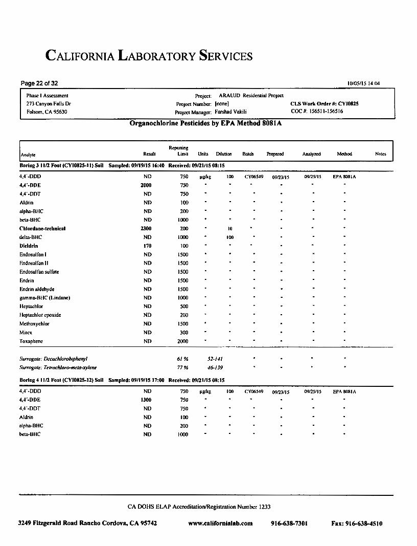
CALIFORNIA LABORATORY SERVICES
Page 22 of32 10/05115 14 04
Phase I Assessment Project: ARAUJO Residential Project
273 Canyon Falls Dr Project Number: [none] CLS Work Order II: CVI082S
Folsom, CA 95630 Project Manager: Farshad Vakili COC II: 156511-156516
Organochlorine Pesticides by EPA Method 8081A
Reporting Analyte Result limit Units Dilution Hatch Prepared Analyzed Method Notes
Boring J 1112 Foot (CVI082S-II) Soil Sampled: 09n9/IS 16:40 Received: 09121/15 08: IS
4,4'-DOO NO 750 IJg/ltg 100 CY06S49 09123/IS 09125115 EPA8081A
4,4"-DDE 2000 750
4,4'-0DT ND 750
Aldrin ND 100
alpha-BHC NO 200
beta-BHC NO 1000
Cblordaoe-tecboical 2300 200 10
delta-BHC NO 1000 100
Dieldrin 170 100
Endosulfan I NO 1500
Endosulfan II NO 1500
Endosulfan sulfate NO 1500
Endrin NO 1500
F.ndrin aldehyde NO 1500
gamma-BIIC (Lindane) NO 1000
Heptachlor NO 500
Heptachlor epoxide ND 200
Methoxychlor ND 1500
Mirex NO 300
Toxaphene NO 2000
Surrogale: Decach/orobiphenyl 6/% 52-141
Surrogale: Telrochloro-mela-xy/ene 77% 46-/39
Boring 4 1112 Foot (CVI082S-12) Soil Sampled: 09n9/IS 17:00 Received: 09121/15 IN!: IS
4,4'-00D NO 750 IJg/ltg 100 CY06549 09123/IS 09125115 EPA808JA
4,4"-DDE 1300 750
4,4'-DDT NO 750
Aldrin NO 100
alpha-BHC NO 200
beta-BHC NO 1000
CA DOHS ELAP Accreditation/Registration Number 1233
3249 Fitzgerald Road Rancho Cordova, CA 95742 www.californialab.com 916-638-7301 Fax:916-638-4510

CALIFORNIA LABORATORY SERVICES
Page 23 of32 10/05/15 14 04
Phase I Assessment Project: ARAUJO Residential Project
273 Canyon Falls Dr Project Number: (none] CLS Work Order #1: CYI08l5
Folsom, CA 95630 Project Manager: Farshad Vakili coc #: 156511-156516
Organochlorine Pesticides by EPA Method 8081A
Reporting
Analyte Result Limit Units Dilution Batch Prepared Analyn:d Method Noles
Boring 4 11/l Foot (CYI082S-12) Soil Sampled: 09/19/15 17:00 Received: 09/21/15 08:15
Chlordane-technical 1800 200 l!g/1cg 10 CY06S49 09nSIIS EPA8081A
delta-BHC ND 1000 100
Dieldrin 170 100
Endosulfan I ND 1500
Endosulfan II ND 1500
Endosulfan sulfate ND 1500
Endrin ND 1500
Endrin aldehyde ND 1500
gamma-BHC (Lindane) ND 1000
Heptachlor ND 500
Heptachlor epoxide ND 200
Methoxychlor ND 1500
Mtrcx ND 300
Toxaphene NO 2000
Surrogate: Decach/orobiphenyl 59% 52-141
Surrogate: Tetroch/oro-mera-xylene 74% 46-/39
BoringS 11/21.-oot (CYIOSlS-13) Soil Sampled: 09119/15 16:13 Received: 09/21/15 08:15
4,4'-DDD NO 75 llg/1c& 10 CY06549 09123/15 09nStiS EPA8081A
4,4'-DDE 1400 7SO 100
4,4'-DDT 370 75 10
Aldrin ND 10
alpha-BHC ND 20
bcta-BHC ND 100
Cblordane-tecbnical 1800 200
delta-BHC ND 100
Dieldrin 140 10
Endosulfan I ND ISO
Endosulfan II ND ISO
Endosulfan sulfate ND ISO
CA DOHS ELAP Accreditation/Registration Number 1233
3249 Fitzgerald Road Rancho Cordova, CA 95742 www.califomialab.com 916-638-730 I Fax:916-638-4510

CALIFORNIA LABORATORY SERVICES
Page 24 of32
Phase I Assessment
273 Canyon Falls Dr Folsom, CA 9S630
Analyte
BoringS 11/2 Foot (CYJ0825-13) Soil
Endrin
Endrin aldehyde
gamma-BHC (Lindane)
Heptachlor
Heptachlor epoxide
Methoxychlor
Mtrex
Toxaphene
Surrogate: Decach/orobiphelf)'l
Surrogate: Tetroch/oro-meta-xylene
Boring 6 11/2 Foot (CYI0825-14) Soil
4,4'-DDD
4,4'-DDE
4,4'-DDT
Aldrin
alpha-BHC
beta-BHC
Cblordant-ttcbniral
delta-BHC
Dieldrin
Endosul fan I
Endosul fan II
Endosulfan sulfate
Endrin
Endrin aldehyde
gamma-BIIC (Lindane)
Heptachlor
Heptachlor epoxide
Methoxychlor
Project: ARAUJO Residential Project
Project Number: [none]
Project Manager: Farshad Vakili
Organochlorine Pesticides by EPA Method 8081A
Reponing Result Limit Units Oil uti ()II Hatch Prepared
Sampled: 09/19115 16:13 Received: 09/21/15 08:15
ND ISO pglkg 10 CY06S49
ND ISO
ND 100
ND so ND 20
ND ISO
ND 30
ND 200
72% 52-141
83% 46-139
Sampled: 09/19/JS IS:SS Received: 09/21/IS 08:15
ND 7S pglkg 10 CY06S49 09123/IS
930 380 so 200 1S 10
ND 10
ND 20
ND 100
1300 200
ND 100
36 10
ND ISO
ND ISO
ND ISO
ND ISO
ND ISO
ND 100
ND so ND 20
ND ISO
CA DmiS ELAP Accreditation/Registration Number 1233
10/0SIIS 14:04
CLS Work Order II: CYI082S coc #: 156Sll-IS6516
Analyzed Method
09/2S/IS EPA8081A
0912SIIS EPA 808IA
Notes
3249 Fitzgerald Road Rancho Cordova. CA 95742 www.califomlalab.com 91~8-7301 Fax:916-638-4SIO

CALIFORNIA LABORATORY SERVICES
Page 25 of32
Phase I Assessment
273 Canyon Falls Dr
Folsom. CA 95630
Analyte
Boring 6 I 1/2 Fool (CYI082S.t4) Soil
Mirex
Toxaphene
Surrogate: Decachloroblphenyl
Surrogate: Terrach/oro-meta-xylene
Boring 7 11/2 Fool (CYI082.~15) Soli
4,4'-DDD
4,4'-DDE
4,4'-DDT
Aldrin
alpha-BHC
beta-BHC
Cblordan~lerbniral
delta-BliC
Dieldrin
Endosulfan I
F.ndosul fan II
Endosulfan sulfate
Endrin
Endrin aldehyde
gamma-BHC (Lindane)
Heptachlor
Heptachlor epoxide
Methoxychlor
Mirex
Toxaphene
Surrogate: Decach/oroblphenyl
Surrogate: Tetroch/oro-meta-xylene
Project: ARAUJO Residential Project
Project Number: (none]
Project Manager: Farshad Vakili
Organochlorine Pesticides by EPA Method 8081A
Reponing Result Umit Units Dilution Batch Prepared
Sampled: 09/19/15 15:55 Rereived: 09/21115 08:15
ND 30 IJsJkg 10 CY06549
ND 200
75% 52-f./1
81% .f~/39
Sampled: 09/19n5 17:17 Rereived: 09/21/15 08: IS
ND 75 IJg/kg 10 CY06549 09123115
1800 750 100
410 7S 10
ND 10
ND 20
ND 100
2200 200
ND 100
190 10
ND ISO
ND ISO
ND ISO
ND ISO
NO ISO
ND 100
ND so ND 20
ND ISO
ND 30
ND 200
81% 52-U/
86% -16-139
CA OOHS ELAP Accreditation/Registration Number 1233
10/05/15 14.04
Cl..S Work Order#: CYI0825 coc #: 156511-156516
Analyzed Method
09/25/IS EPA8081A
09125115 EPA8081A
Noles
3249 Fitzgerald Road Rancho Cordova. CA 95742 www.californialab.com 916-638-7301 Fax:916-638-4510

CALIFORNIA LABORATORY SERVICES
Page 26of32
Phase I Assessment
213 Canyon Falls Dr
Folsom, CA 95630
Analyte
Boring 8 I Ill Foot (CYI082S-16) Soil
4,4'-DDD
4,4'-DDE
4,4'-DDT
Aldrin
alpha-BHC
beta-BHC
Cblordant-ttrbniral
delta-BHC
Dieldrin
Endosulfan I
Endosulfan II
Endosulfan sulfate
Endrin
Endrin aldehyde
gamma-BHC (Lindane)
Heptachlor
Heptachlor epoxide
Methoxychlor
Mirex
Toxaphene
Surrogate: Derochlorobiphenyl
Surrogate: Tetrachloro-meta-:rylene
Project: ARAUJO ResidentiaJJ>roject
Project Number: (none)
Project MIUUigcr: Farshad Vakili
Organochlorine Pesticides by EPA Method 8081A
Reponing Result limit Units Dilution
Sampled: 09/19n5 16:10 Rerelvtd: 09/ll/15 08:15
NO 1S IIIJikg 10 CY06S49 09123/IS
1100 380 so 140 1S 10
NO 10
NO 20
NO 100
1400 200
NO 100
41 10
NO ISO
NO ISO
NO ISO
ND ISO
NO ISO
NO 100
NO so NO 20
ND ISO
NO 30
ND 200
78% 52-141
84% 46-/39
CA OOHS ELAP Accreditation/Registration Number 1233
10/05/15 14:04
CI.S Work Order II: CYI08l5 COC II: IS6Sli-IS6SI6
Analyzed Method
09125115 EPA 8081A
Notes
3249 Fitzgerald Road Rancho Cordova, CA 95742 www.callfomialab.com 916-638-7301 Fax: 916-638-4510

CALIFORNIA LABORATORY SERVICES
Page 27 of32
Phase I Assessment
273 Canyon Falls Dr
Folsom, CA 95630
Batch CY06497- EPA 7471A
Blank (CY06497-BLKJ)
Mercury
I.CS (CY06497-BSJ)
Mercury
Malrb Splkt (CY06497-MSJ)
Mercury
Molril Spike Dup (CY06497-MSDI)
Mercury
Batch CY06498- EPA 30508
Bloak (CY06498-BLKI)
Antimony
Arsenic
ltarium
Selenium
81.'1}'1lium
Thallium
Cadmium
Cobalt
Chromium
COJlper
lead
Molybdenum
Nickel
Silver
Vanadium
Zinc
Result
NO
0.359
Project: ARAUJO Residential Project
Project Number: [none)
Project Manager: Farshad Vakili
CAM 17 Metals -Quality Control
Reporting
Limit Units
Spike
l.a-el Soun:e Result %REC
Prepared & Anolyzed: 09/22/15
0.10 mglkg
Prepared & Analyzed: 09/22/15
0.10 mglkg 0.250 143
Soun:e: CYI0763-0I Prepared & Analyzed: 09/22/15
0.306 0.10 mglkg 0.250 NO 122
Soun:e: CYI0763-0I Prcpored & Analy;r..ed: 09/22/15
0.307 0.10 mglkg 0.250 Nl> 123
Prepared & Analyzed: 09122115
Nl> 2.S mglkg
NO 0.20
NO 1.0
NO 0.50
NO 1.0
NO 0.20
NO 1.0
NO 1.0
NO 10
NO 10
ND 2.5
ND 1.0
NO 1.0
NO 1.0
NO 1.0
NO 1.0
CA OOHS ELAP Accreditation/Registration Number 1233
10/05/151404
CI.S Work Order#: CYIOBlS coc #: 156511-156516
%REC Limits
75-125
75-125
75-125
RPO
0.3
RPO
Limit
25
NOles
QM-1
3249 Fitzgerald Road Rancho Cordova, CA 95742 www.califomialab.com 916-638-730 I Fax: 916-638-4510
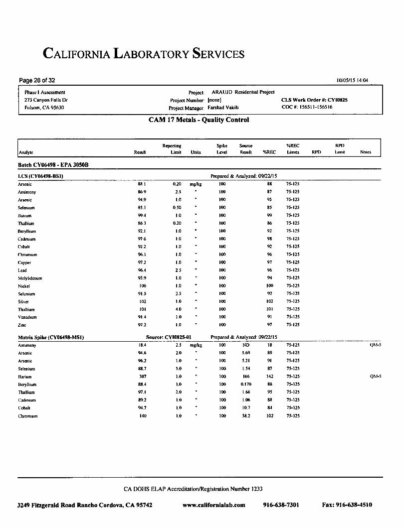
CALIFORNIA LABORATORY SERVICES
Page 28 of32
Phase I Assessment
273 Canyon Falls Dr
Folsom. CA 95630
Anal)1e
Batch CV06498 ·EPA 30508
LCS (CY06498-BSI)
Arsenic
Antimuny
Arsenic
Selenium
B3llum
Thallium
Beryl hum
Cadmaum
Cobalt
Chromium
Copper
lead
Molybdenum
Nickel
Selenium
Silver
Thallium
Vanadium
Zane
Matri1 Spike (CY06498-MSI)
Antimony
Arsenic
Arsenic
Selenium
BMium
Betylhum
Thallium
Cadmium
Cobalt
Cltromium
Project: ARAUJ[) Rl.'Sidential Project
Project Number: [none)
Project Manager: Farshad Vakili
CAM 17 Metals - Quality Control
Reponing Spike Source Rcsuh Limit Units Level Rcsuh %RF.C
Prepared & Analyzed: 09122115
88.1 0.20 mglkg 100 88
86.9 2.5 100 87
94.9 1.0 100 95
85.1 0.50 100 85
99.4 1.0 100 99
86.3 0.20 100 86
92.1 1.0 100 92
97.6 1.0 100 98
92.2 1.0 100 92
96.1 1.0 100 96
97.2 1.0 100 97
96.4 2.5 100 96
93.9 1.0 100 94
100 1.0 100 100
91.5 2.5 100 92
102 1.0 100 102
101 4.0 100 101
91.4 1.0 100 91
97.2 1.0 100 97
Sourer: CYI082S-OI Prepared & Analyzed 09122115
18.4 2.5 mglkg 100 NO 18
94.6 2.0 100 5.69 89
96.2 1.0 100 5.21 91
88.7 5.0 100 1.54 87
307 1.0 100 166 142
88.4 1.0 100 0.170 88
97.1 2.0 100 1.66 95
89.2 1.0 100 1.06 88
94.7 1.0 100 10.7 8-1
140 1.0 100 38.2 102
CA DOiiS ELAP Accreditation/Registration Number 1233
10/05/15 14:04
CLS Work Order II: CYI082S coc #: 156511-156516
%RF.C RPD
Limits RPO Limit Notes
7S-12S
75-125
75-125
75-125
75-125
75-125
75-125
75-125
75-125
75-125
75-125
75-125
75-125
75-125
75-125
75-125
75-125
15-125
75-125
75·125 Q!\1·5
75-125
75-125
75-125
15·125 QXI-S
75-125
15·125
75-125
75-125
75-125
3249 Fitzgerald Road Rancbo Cordova, CA 95742 www.califomialab.com 916-638-7301 Fax:916-638-4510

CALIFORNIA LABORATORY SERVICES
Page 29of32 10/05/15 14 04
Phase I Assessment Project ARAUJO Residential Project
273 Canyon Falls Dr Project Number: [none] Cl.S Work Order II: C\'10825
Folsom. CA 95630 Project Manager: Farshad Vakili coc I#; 156511-156516
CAM 17 Metals - Quality Control
Reponing Spike Soutu o/oREC RPO Analyte Resull Umil UniiS Level Resull %REC LimiiS RPO Limil Noles
Batch C\'06498- EPA 30508
Malri~ Spike (C\'06498-MSI) Source: C\'10825-01 Prepared & Analy1~: 0912211 S
Copper 142 1.0 mglkg 100 41.7 100 15-125
Lead 1430 2.5 100 9.7S NR 75-12S QM-5
Molybdenum 81.S 1.0 too 0.995 110 15-125
Nickel 187 1.0 100 78.9 t08 7S-t25
Selenium 76.7 2.S tOO NO 77 15-125
Silver 94.9 1.0 100 NO 95 15-125
Thallium 78.9 4.0 tOO NO 79 75-125
Vanadium 121 10 tOO 29.6 91 75-125
Zinc 173 1.0 tOO 64.7 108 7S-12S
Matril Spike Dup (C\'06498-MSDI) Source: C\'10825-01 Prepared & Analyzed: 09122/IS
Antimony 26.2 2.S mglkg tOO NO 26 75-125 35 30 Q!\I·S
Arsenic tOO 1.0 100 S.21 9S 15-125 4 30
Barium 313 1.0 100 166 147 75-125 2 30 QM-S
Beryllium 91.6 1.0 tOO 0.170 91 15-125 4 30
Cadmium 92.4 1.0 100 1.06 91 75-125 4 30
Coball 98.8 1.0 100 10.7 88 75-125 4 30
Chromium IS2 1.0 tOO 38.2 114 15-125 8 30
Copper 145 1.0 100 41.7 104 75-125 2 30
Lead 106 2.5 100 9.7S 96 75-125 173 30 Ql\1-5
Molybdenum 86.4 1.0 100 0.99S 85 75-125 6 JO
Nickel 217 1.0 100 78.9 138 75-125 IS 30 QM-5
Selenium 78.5 2.S tOO NO 78 75-125 2 30
Stiver 98.0 1.0 100 ND 98 7S-t2S 3 30
Thallium 80.8 4.0 100 ND 81 7S-t2S 2 30
Vanadtum 131 1.0 100 29.6 tOt 75-125 8 30
Zinc 186 1.0 100 64.7 121 75-125 7 30
CA DOHS ELAP Accreditation/Registration Number 1233
3249 Fitzgerald Road Rancho Cordova, CA 95742 www .californiala b.com 916-638-7301 Fax: 916-638-4510

CALIFORNIA LABORATORY SERVICES
Page 3D of32 10/05/15 14 04
Phase I Assessment
273 Canyon Fulls Dr
Folsom. CA 95630
Project: ARAUJO R1:sidential Project
Project Number: [none)
Project Manager. Farshad Vakili
CLS Work Order 1#: CYI082S
coc 1#: 156511-156516
Organochlorine Pesticides by EPA Method 8081A- Quality Control
Reporting Spike Source %REC RPD
Analyte Result Limit Units Level Result o/oREC Limits RPD Limit NOles
Bateb C\'06549- LUFT-DHS GCNV
Blank (CY06549-BI.KI) Prepared: 09123/15 Analyzed: 09125/15
Aldrin NO 1.0 ~tglks
alpha·BHC ND 2.0
bet3·BHC NO 10
delta·BHC NO 10
gamma·BHC (l.indlllle) NO 10
Chlordllllc-technical NO 20
4,4'·000 NO 7.5
4,4'·DDE NO 1.5
4,4'·00T NO 75
Diddnn NO 1.0
Endosulf1111 I NO 15
Endosulf1111 II ND IS
Endosulf1111 sulfate NO IS
Endnn ND IS
Endrin aldehyde NO IS
Heptachlor NO 5.0
I leptachlor epoxide NO 2.0
Methoxychlor NO IS
Mirex NO 3.0
Toxaphene NO 20
SurrtJKUt~: T~troch/oro-m~ta-:rylm~ 5.69 8.JJ 68 46-/39
SuTrtJKUt~: lxcm:h/orol>lpMnyl 7.U 8.JJ 87 52-J.II
LCS (CY06549-BSI) Prepared: 09123/15 Analyzed: 09125/15
Aldrin 11.8 1.0 l'&~kg 16.7 11 47-132
gamma.BHC (l.indlllle) 11.7 tO 16.7 70 56-t33
4.4'·00T 13.3 7.S 16.7 80 46-t37
Dieldrin 13.2 1.0 16.7 79 44-143
Endrin 14.S IS 16.7 87 30..147
Heptachlor 11.6 s.o 16.7 70 33·148
Surrogate: 1'rtruch/"n>-melu·xylmr 5.29 8.33 IIJ 411-139
CA DOUS ELAP Accreditation/Registration Number 1233
3249 Fitzgerald Road Rancho Cordova, CA 95742 www.ealifornialab.com 916-638-7301 Fax: 916-638-4510

CALIFORNIA LABORATORY SERVICES
Page 31 of 32 10/05115 14:04
Project: ARAUJO Residential Project Phase l Assessment 273 Canyon Falls Dr Folsom, CA 95630
Project Number. I none] Project Manager: Farshad Vakili
C I.S Work Order II: CYIOII25
coc #: 156511-156516
Organochlorine Pesticides by EPA Method 8081A- Quality Control
Rcpor1ing Spike Source %REC RPD Anolyle Result Limit Units Level Result %REC Limits RPD Limit Notes
Batch CV06549 - LUJr J'-OIIS GC!I.'V
LCS (CY06S49-BSI ) Prepared. 09/23/15 Analy7.ed: 09/25/15
SurrtJ}!tlll. f)~cachlorobtphcnyl 7.16 I'll. kf!. 8.33 86 S1-J.II
LCS llup (CY06549-BSOI) Prepared: 09/23/15 Analyzed: 09/25/15
Aldrin 11.0 1.0 fig/kg 16.7 66 47-IJ2 8 30
gammo-BIIC (Lindane) 10.6 10 16.7 63 56-133 10 30
4,4 '-DDT 12.2 7.5 16.7 73 46-137 9 30
Otcldnn 12.0 I 0 16.7 72 44-1-13 10 30
Endnn 13.2 IS 16.7 79 30- 147 10 30
1kptachlor 10.6 S.O 16.7 64 33-148 9 30
~ltrm~:arc: Tetracltloro-mcta·xy /enc 4.96 8.33 59 46-139
Sum>}::atc: Decach!orohiplwnyl 6.46 8.33 78 S2- /-ll
)1nlrix S ]like (CYOGS-49-MS I) Source: CYI0825-0 l Prepared· 09123/ 15 Analyzed: 09/25/ 15
Aldnn IS.6 10 11g/l.g 16.7 NO 93 47-138
gammB·IliiC (Lindane) 16.6 100 16 7 NO 99 38-144
4,4'-00T 238 1S 16 7 192 2H 41-IS7 QM·S
Oocldnn 50.9 10 16.7 37.8 78 46-ISS
Endrin 86.9 ISO 16.7 NO 521 34-1 ,19 Q~t-5
I lcptnchlor 11.3 50 16 7 NO 68 36-ISS
Surragat.: Tetrachloro-meta·:t}ltne 18. 1 20.8 87 ./6-139
Surrr)J!at~: J)ccachlorobtphenyl 17.-1 208 83 SZ-1-11
)!nlril: Spike Dup (CY065-49-MSOI) Source: CYI0825-0 I Prepared: 09/23/1 5 Analyzed: 09/25/15
i\ldrin 15.2 10 pgll.g 16.7 NO 91 47-138 2 35
gamrna-OIIC (Lindane) 17.1 100 16.7 NO 103 38- 144 35
•1.4'-00T 22 1 1S 16.7 1?2 170 4 1-IS7 8 35 Ql\1 -5
Docldrin 50.2 10 16.7 37.8 7-1 46-ISS 3S
Endnn 84.6 ISO 16.7 ND 507 34-149 3 35 Q~t-5
Heptachlor 11.2 so 16.7 ND 67 36-ISS 35
.\itrro~:mr: 1-,.trachloro-meta·:t}lt'll~ /6.9 20/J 8 1 -16- /39
Surr(}J:OIC: /)ccachlorohtphcll,l'l / 8.8 20./J 90 52- I-I/
CA DOllS ELAP Accreditation/Registration Number 1233
3249 Fitzgerald Road Rancho Cordova, CA 95742 www.californialab.com 916-638-7301 Fax: 916-638-4510

CALIFORNIA LABORATORY SERVICES
Page 32 of32 10105/15 14 04
Phase I Assessment
273 Canyon Falls Dr
Folsom, CA 95630
Project: ARAUJO Residential Project
Project Number: [none)
Project Manager: Farshnd Vakili
CLS Work Ordtr #: CVJ082S coc #: 156511-156516
Notes and Definitions
QM-5 The spike recovery wns outside acceptance limits ror the MS and/or MSD due to matrix interference. 'The I.CS and/or LCSD were within acceptance limits showing that the laboratory is in control and the data is acceptable.
QM-1 The spike recovery WIIS outside acceptance limits ror the LCS or LCSD. The batch WIIS accepted based on acceptable MSIMSD recoveries & RPD's.
QB-1 The method blank or calibration verfication blank contains analyte at a concentration above the MRL; however, concentration is less than 10% ofthe sample result. which is negligible according to method criteria.
DET Analyte DETECTED
NO Analyte NOT DETECTED at or above the reporting limit (or method detection limit when specified)
NR Not Reported
dry Sample results reported on a dry weight basis
RPD Relllli>-e l'a'c:cnl DiiTcrcncc
CA DOHS ELAP Accreditation/Registration Number 1233
3249 Fitzgerald Road Rancho Cordova, CA 95742 www.c:alifornlalab.com 916-638-7301 Fax: 916-638-4510

CALIFORNIA LABORATORY SERVICES
Page 1 of32 10105/15 14:04
Project: ARAUJO Residential Project Phase I Assessment 273 Canyon Falls Dr
Folsom, CA 95630
Project Number: [none) CLS Work Order#: CYI082S
Project Manager: Farshad Vakili COC #: 156511-156516
I r-f ----- JOJ} ,"co"''::_~~-. _06'5-tr/f .c:~f __ (JO,f'j_ _ ---
SHIPPED BY. :J X [J UPS l J OTHER . __ . •------ --- --- --- ------------- . -- -
AJR Bill I
CA DOHS ELAP Accreditation/Registration Number 1233
3149 Fitzgerald Road Rancho Cordova, CA 95741 www.californialab.com 916-638-7301 Fax:916-638-4510

CALIFORNIA LABORATORY SERVICES
Page2 of32
J>hase I Assessment 273 Canyon Falls Dr
Folsom, CA 95630
~----~~- ~ 'I'("DM\.A3~
~---~~~~~ SH!Pl'ED BY: ,
~------- ----- ___ _:_--=:_______ - ~-
10/05/15 14:04
Project: ARAUJO Residential Project
Project Number: (none) CI..S Work Ordtr #: CYI0825 Project Manager: Farshad Vakili COC II 156511-156516
-··.,.. I ,
-- ~-
1
CA DOllS ELAP Accreditation/Registration Number 1233
3249 Fitzgerald Road Rancho Cordova, CA 95742 www.californialab.com 916-638-7301 Fax:916-638-4510


APPENDIX D
ARAUJO STREET SUBDIVISION RESIDENTIAL TRAFFIC STUDY

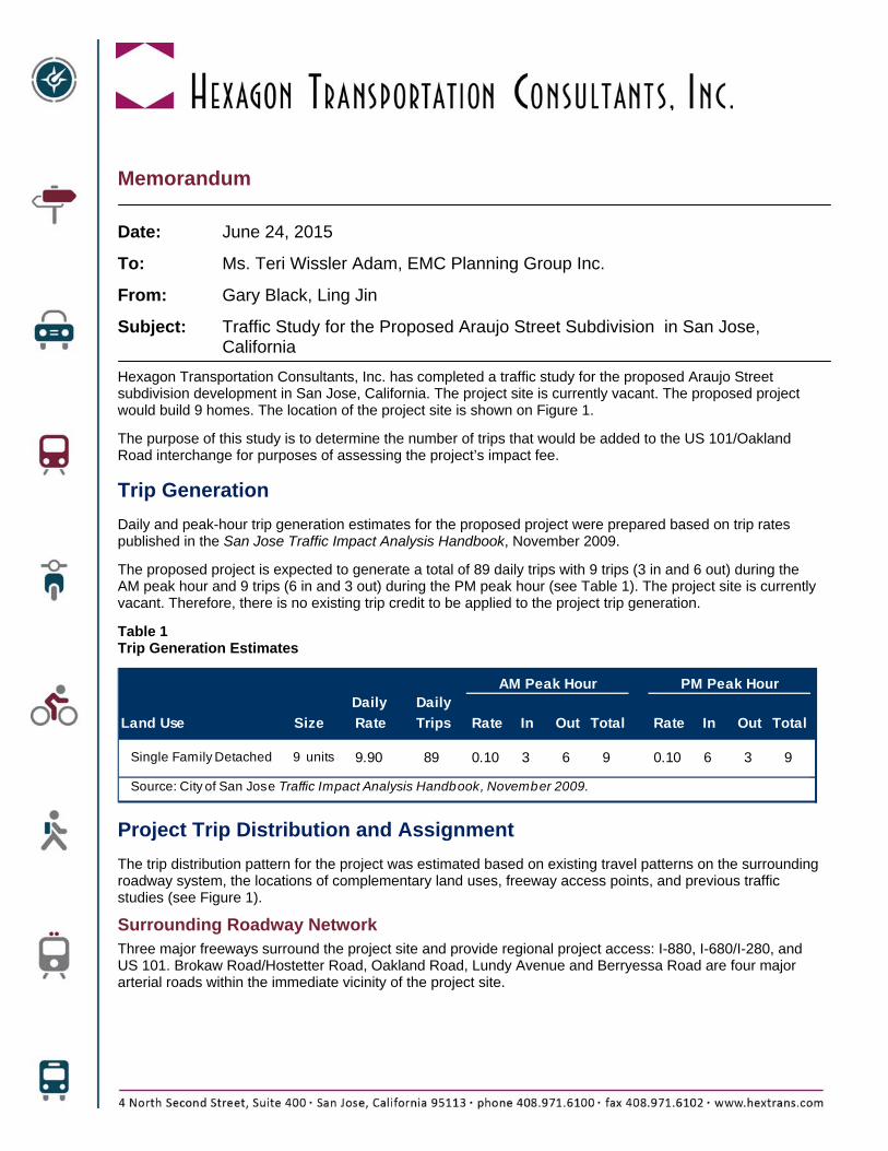
Memorandum
Date: June 24, 2015
To: Ms. Teri Wissler Adam, EMC Planning Group Inc.
From: Gary Black, Ling Jin
Subject: Traffic Study for the Proposed Araujo Street Subdivision in San Jose, California
Hexagon Transportation Consultants, Inc. has completed a traffic study for the proposed Araujo Street subdivision development in San Jose, California. The project site is currently vacant. The proposed project would build 9 homes. The location of the project site is shown on Figure 1.
The purpose of this study is to determine the number of trips that would be added to the US 101/Oakland Road interchange for purposes of assessing the project’s impact fee.
Trip Generation
Daily and peak-hour trip generation estimates for the proposed project were prepared based on trip rates published in the San Jose Traffic Impact Analysis Handbook, November 2009.
The proposed project is expected to generate a total of 89 daily trips with 9 trips (3 in and 6 out) during the AM peak hour and 9 trips (6 in and 3 out) during the PM peak hour (see Table 1). The project site is currently vacant. Therefore, there is no existing trip credit to be applied to the project trip generation.
Table 1 Trip Generation Estimates
Daily Daily
Land Use Rate Trips Rate In Out Total Rate In Out Total
Single Family Detached 9 units 9.90 89 0.10 3 6 9 0.10 6 3 9
Source: City of San Jose Traffic Impact Analysis Handbook, November 2009.
AM Peak Hour PM Peak Hour
Size
Project Trip Distribution and Assignment
The trip distribution pattern for the project was estimated based on existing travel patterns on the surrounding roadway system, the locations of complementary land uses, freeway access points, and previous traffic studies (see Figure 1).
Surrounding Roadway Network Three major freeways surround the project site and provide regional project access: I-880, I-680/I-280, and US 101. Brokaw Road/Hostetter Road, Oakland Road, Lundy Avenue and Berryessa Road are four major arterial roads within the immediate vicinity of the project site.

Traffic Study for Proposed Araujo Street Subdivision June 24, 2015
P a g e | 2
Trip Routes Trips to/from I-880 north of the project site are expected to access the project site via the I-880/Brokaw Road interchange, and then travel on E Brokaw Road/Murphy Road for less than a mile. This interchange is approximately 2 miles northwest of the project site. These trips will use the surrounding local roads to access the project site: Oyama Drive, Sajak Avenue, Townsend Avenue, and Araujo Street. This route is both the fastest and shortest route.
Trips to/from US 101 north are expected to access the project site via the US 101/Oakland Road interchange. This interchange is approximately 2 miles southwest of the project site. These trips are expected to access the project site by using Commercial Street, Berryessa Road and Sierra Road. This route is both the fastest and shortest route. Another potential route is to use the I-880/Brokaw Road interchange and travel on I-880 and SR 237 then change to US 101 north. Compared to the shortest route, this route is 1.5 miles longer and also requires 3 minutes more travel time. Therefore, it is expected that trips to/from US 101 north will use the US 101/Oakland Road interchange (see Figure 1).
Trips to/from US 101 south have two potential routes to access the project site. The shortest and fastest route is to use the US 101/Oakland Road interchange and then travel on local roads including Commercial Street, Berryessa Road, Sierra Road, and Araujo Street for approximately 2.2 miles. The other potential route is to use US 101 to I-680 and the I-680/Berryessa Road interchange. Trips then travel on Berryessa Road and turn right to Sierra Road then turn left to Araujo Street to access the project site. Compared to the shortest route, this route is 1.5 miles longer, and would take 1 minute more in total travel time. Therefore, it is expected that trips to/from US 101 south will use the US 101/Oakland Road interchange (see Figure 1).
Trips to/from I-880 south have two potential routes to access the project site. The shortest route is to use I-880 to US 101 and use the US 101/Oakland Road interchange. Then these trips can use Mabury Road, Berryessa Road and Sierra Road, and Araujo Street to access the project site. The fastest route is to use I-880/Brokaw Road interchange, then travel on E Brokaw Road/Murphy Road for less than a mile and continue on surrounding local roads to access the project site. Compared to the shortest route, this route is 0.5 miles longer, but would take 2 minutes less in total travel time. The travel time saving by choosing the fastest route may offset the 0.5 miles shorter travel distance by using the shortest route. Therefore, it is expected that trips to/from I-880 south will stay on I-880 and would not use the101/Oakland Road interchange.
The project site is located on the west side of Oakland Road, and there is no direct connection between Oakland Road and the project site. Therefore, all local trips to/from the downtown area are expected to access the project site by using Hedding Street/Berryessa Road to Sierra Road.
US 101/Oakland/Mabury Transportation Development Policy (TDP) The City of San Jose has identified operational problems along the Oakland Road corridor at the US 101 interchange, which are due primarily to the capacity constraints of the interchange. The interchange’s current configuration is inadequate to serve the vehicular demand due to it serving as the main gateway into the Oakland Road area and as the only route across US 101. As a result, the City has identified two key capital improvement projects: 1) modification of the US 101/Oakland Road interchange, including improvements to the Oakland Road/Commercial Street intersection, and 2) construction of a new US 101/Mabury Road interchange. Both interchange projects will create additional capacity for accessing and crossing US 101, which will be crucial to accommodate future growth in the vicinity, including the future BART station at the San Jose Flea Market site. To fund these necessary interchange improvements, the City has developed the US 101/Oakland/Mabury Transportation Development Policy (TDP).
As part of the new Policy, a fee to fund the planned interchange improvements has been adopted. The fee is based on PM peak hour vehicle trips generated by a project. Any project that would add traffic to the US 101/Oakland Road interchange is required to participate in the TDP program. The TDP includes a fee schedule requiring all new developments to pay a “fair share” contribution for using a portion of the interchange capacity that would be created with buildout of the US 101/Oakland Road interchange and construction of a new US 101/Mabury Road interchange. Unlike most Area Development Policies that base their fees on the number of residential units or square footages built, the fee for the US 101/Oakland/ Mabury TDP is based on the number of PM peak hour vehicular trips that would be added to the US 101/Oakland Road interchange (including the Oakland Road/Commercial Street intersection).

Traffic Study for Proposed Araujo Street Subdivision June 24, 2015
P a g e | 3
Since the proposed project would send some PM peak hour vehicle trips through the US 101/Oakland Road interchange, the project would be required to pay a fair share contribution toward the planned interchange improvements. The current TDP traffic impact fee is $34,913 per each new PM peak hour vehicle trip that would be added to the US 101/Oakland Road interchange. The project would add 3 new trips to the interchange during the PM peak hour of traffic.
Estimated US 101/Oakland/Mabury TDP Impact Fee: $34,913 x 3 net PM peak hour trips = $104,739.
Conclusions
The purpose of this study was to determine the number of trips that would be added to the US 101/Oakland Road interchange for purposes of assessing the project’s impact fee. The key findings are summarized below.
The proposed project is expected to generate a total of 89 daily trips with 9 trips (3 in and 6 out) during the AM peak hour and 9 trips (6 in and 3 out) during the PM peak hour.
Based on the surrounding land uses and the existing roadway network, it is expected that 3 project trips would use the US 101/Oakland Road interchange during the PM peak hour, and the proposed project would need to pay a total of $104,739 impact fee (based on the current rate of $34,913 per trip).
